Embed Size (px)
Citation preview
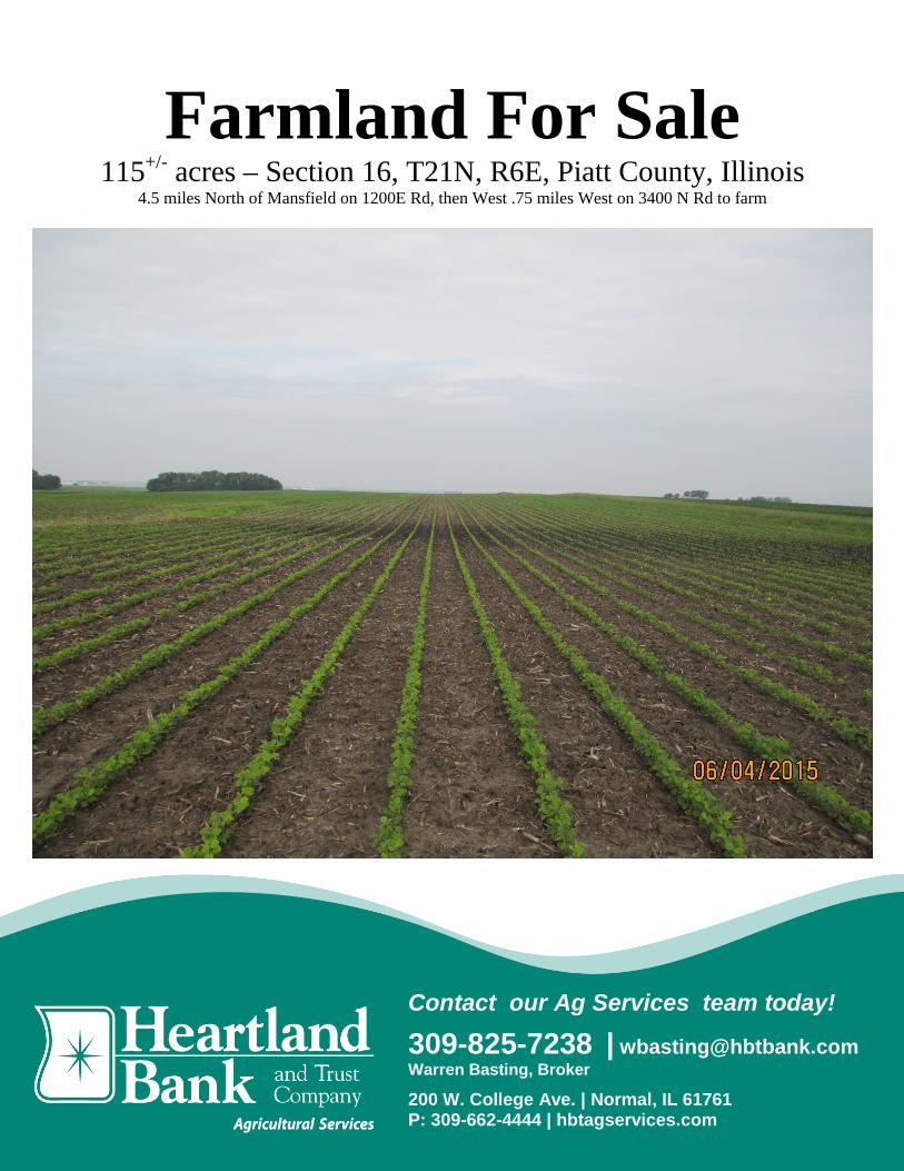
Farmland For Sale 115+/- acres – Section 16, T21N, R6E, Piatt County, Illinois
4.5 miles North of Mansfield on 1200E Rd, then West .75 miles West on 3400 N Rd to farm
Contact our Ag Services team today!
309-825-7238 | [email protected] Warren Basting, Broker
200 W. College Ave. | Normal, IL 61761 P: 309-662-4444 | hbtagservices.com

Farmland For Sale – Piatt County, Illinois
Acres1 Location2 Township/Section PIN # 1 115+/- 4.5 miles N of Mansfield
& .75 miles West T21N, R6E, Section 16 02-16-21-006-001-00
Sale Terms6: Yield History*:
* Information provided by Owner
Soil Test levels average *:
* Information provided by Owner
FSA#4 Soil PI3 Major Soil Types3 HEL4 or CRP4 21881 135.4 Flanagan, Dana, Drummer, El Paso None
Year Corn* Seed SB* 2014 235 -- 2013 -- 52.3
Terms6: Ten percent (10%) down payment will be required from Buyer at execution of the purchase contract. Balance will be due seller at closing. Closing will be scheduled within 30 days of the signing of the contract. Owner is retaining the 2015 crop.
Title6: Seller will furnish Buyer a title policy in the amount of the purchase price subject to the usual and customary exceptions. Mineral rights if any will be conveyed with the land unless otherwise specified in the contract.
Taxes6: 2015 Real estate taxes, due in 2016, shall be given as a credit to the Buyer at the time of closing. All subsequent year taxes shall be the responsibility of the Buyer.
Possession6: Seller will give possession after closing and following harvest subject to the Tenant’s 2015 lease. 2015 Lease is with Eric Steers.
Agency6: Warren Basting, Broker, is the designated agent with Heartland Bank and Trust Co., licensed Real Estate Broker Corp, represents the Seller of the subject property.
Disclosure6: 6While the information contained in the brochure is considered accurate; it is subject to the Buyer’s own verification. The Seller, and Heartland Bank and Trust Co, assumes no liability for errors or omissions and reserves the right to alter terms of the listing.
1. Acres are taxable acres; 115+/- acres is being sold and is a part of farm # 2188. Additional acres are being retained by Owner.
2. Locations are approximate 3. Soils data provided by USDA, NRCS and Surety Maps are approximate 4. Data provided by USDA , Piatt County FSA 5. Property borders are approximate, and do NOT reflect actual surveyed boundary line 6. Disclosures
pH = 6.4 P = 39 K = 488
FOR SALE
Distance** from For Sale to: Mansfield- 4.5 miles Mahomet- 9 miles Farmer City- 5.5 miles Bellflower- 4.5 miles ** Mileage is approximate
Google Maps©
2

34
MAD
DEN
2174
LAKEMANSFIELD
S P
RA
IRIE
NLI
BE
RT
Y
HO
L LO
WP
OIN
TH
ILL
SU
NR
ISE
TER
RA
CE
CT
19
R 7
8
Erwin W Trust
160
Chambers Robert W &Lawrence A Etal 69
Grace M Tr 49
Huf
fstu
tler D
wig
htE
40
George R &Faye H 85
Wol
f Rob
ert J
&D
iane
C T
rust
32
SimoneN 31
Donald G& Sharon F
Trust 35
Trust 55
40
George
A
316
CR
Dra
ke S
teph
anie
34
0/150
BLUE RIDGE
W NEWTON AV E NEWTON AV
WSTATE
NM
CK
INLE
Y
2174
0/150
TRENKLE
SL
1318 1617 1415
19 2420 21 22 23
30 29 28 2527 26
31 32 33 3634 35
6 5 4 3 2 1
1211107 8 9
13141518 1617
2423222120
MANSFIELD
SPl k 40 GilbertDairy
ns
00
K 1
48
s&a
wm
F
5
5
Yowell PatriciaA Trust 42
YoungEdwin DEtal 60
Wynne Ann L &Patrick J Etal 237
WrightRobertTrust
78
WrightRobertG Trust
64
Wright-IL Farms LLC 193
Wright-ILFarm LLC 118
Wright-ILFarmsLLC 71
WozniakLouis &JoannTr 94
Wol
f Rob
ert
J &
Dia
ne C
Trus
t 60
Wolf RobertJ & Diane C
Trust 79
Wol
f Rob
ert J
& D
iane
CTr
ust 1
03Wolf
W Trust 37
RobertsDonna D
& Edwin LTr 60
WilsonVerniece
35
WeltonLarry E &
RubyTrust 50
WeltonLarry E &
Doris M 74
WeltonLarry E& Doris
M 50
Welton Larry E 200
Weidner EvelynK Trust 158
Watson LindaJ & Donna J
Etal 158
WarsawRoss O
40WarsawRoss 40
WarsawDonald
D 80 WarsawDonald &
Connie L 77
Warren Arete &Bernice Swartz 320
VangorderStephen
B 58
VangorderStephen
B 54
Universityof IL 40
Um
land
Ste
phen
C 8
0
TrippiediMargaretJ Tr 92
TerstriepJeffrey A &Amy L 157
TatmanEva 160
StigerMaryJ 82
StevensonJane L 120
SnyderFamily
Foundation198
SmithTimothy
J &Jane AEtal 60
SmithJaneA 97
SleezerJudith A
238
SimoneFamily
Trust 86
ShoresLesterL 45
SchroederFamily Etal 234
SchroederFamilyEtal 40
SchnemanRoger L 318
SchnemanPatriciaEtal 40
SchnemanFlora Etal 226
SchneiderEileen H
115
Rust DarwinFifer 400
RuchLarryD &
Karla78
RothThomas A
103
RothScott R &Julie J 50
RothLawrence
H 40
Rot
hLa
wre
nce
A 40
RothHarold
E &Betty J
100
RothHarold
E &Betty J
80
RothHarold
E &Betty J40
RothHarold &Betty 40
Roth Harold& Betty 80
Rot
h B
illy
G &
She
ila M
52
RossWoodward
& HoodMartha
160
RobbSteven J &David W 75
ReederJohn DJr 40
QuaidJohn JFarm
Mngmt157
PremiereFarmProp
LLC 80
Premiere FarmProp LLC 95
Plu
nkTh
omas
M&
Joa
n 15
8
PlunkThomas M &Barbara J 74
Plunk FamilyLandlords 239
Plunk BrosLand
Ptnsp 320
PlunkBros LandPtnsp 40
Plunk Bros Land Ptnsp 507
PlunkB
Joan34
Plotner
PierceDavid RTrust 40
Howe JaneC Trust 75
PheasantFarms
LLC 160
PetersonJudith
PetersMervinG Tr 96
PetersMervinG Tr 45
PetersMervin GTrust 280
PerkinsWayneLE Etal
160
PerkinsFamilyTrust107
Pauling GlenW & Georgette
K Tr 118
ParishHoldings
LP Etal 99
O'BrienMary
Trust 40
Nye PhilipH Jr &
MargueriteG 160
Noel FarmsLLC 121
Noel FarmsLLC 107
Noe J Wesley &Shirley J 80
Noe
J W
esle
y &
Shi
rley
J 80
Nee
f Den
nis
W &
Lilli
an R
42
MorfeyDelores
150
Mon
arch
Farm
sLL
C 7
7
MitchellPottebaumFarms LP
MillerEloise &PoppeWendy
Etal 100
MillerEloise &PoppeWendyEtal 75
Meier
Mcc
orm
ick
Pap
er C
oIn
c 80
McclureDavid C &Marjorie
M 73
McclureDavid C &Marjorie
M 167
McclureDavid C &Marjorie
M 281
McclureDavid C &Marjorie
M 130LingleSusan
80
LamontBarbara KEtal Tr 46
Bea
zly
Ele
anor
R L
EE
tal 3
4
KochMary LTr 40
Kislingbury CKent Tr 76
KiddMary K
160
Kc HermLand LLC 223
KasbergenDairy 40
KasbergenDairy 80
KasbergenDairy 40
Kam
mey
er V
ivia
n L
&Vi
rgil
Trus
t 50
KammeyerVivian L &Virgil Trust
153
KammeyerVivian LTrust 45
KammeyerVivian L
Trust 120
KammeyerVivian H 120
KammeyerVivian H 74
K&MBraddInc 40
JohnstonB
arbaraL 72
JamesJason &Angela
116
James Jason &Angela 120
James JWilbur &Dorthy M
152
James J Wilbur &Dorthy M 120
James CL &
Irrer Ruby Tr 86Irrer Ruby
Tr 160
IncobrasaIL Ltd 236
Hunter BFTrust 79
Hunter BF Trust 160
HuffstutlerDwight E 71
HuffstutlerDwight E
162 HuffstutlerDwight 76
Huf
fstu
tler
Dar
yl R
80
Huf
fstu
tler
Dar
yl 4
3
Huf
fstu
tler
Dar
ryl R
85
HoweRobert WTrust 80
How
e R
ober
t W T
rust
180
How
e R
ober
tW
Tru
st 4
5
HoweMary HTr 80
HoweLott C
80
HoweLott C231
HoweLC 120
HoweLC 40
HoweLC 78
Howe Jane CTrust 164
Howe JMaurice
Tr 80
How
e J
Mau
rice
Tr 8
0
HoweGeorge WTrust 40
Howe GeorgeW Trust 160
HoweGeorge
WTrust
52
Howe GeorgeW Trust 80
Howe FamilyHoldings LLC 120
Hou
se R
oy A
& B
elch
erLu
cille
Tr 8
0
House Roy A& Belcher
Lucille Tr 60
House Roy A& Dorothy D
Trust 60
HouseRA
Etal 40
House Bertha BTrust Etal 79
House Bertha BTrust Etal 110
House Bertha BTrust Etal 80
House Bertha BTrust Etal 154
HibbsDolores
L 80
HendrenProp
LLC 60
Hen
dren
Pro
p LL
C 4
4
Hen
dren
Pro
pLL
C 6
8
Hen
dren
Pro
p LL
C 7
8
HeacockLawrence
& FlynnTamaraD 39
Harper Robert W 50
HarperRobertW 80
HarperCheryl L
311
GeorgeHoweTr 40
Gar
dner
Car
la&
Arm
itano
Kar
en T
rs 5
5
Gar
dner
Car
la&
Arm
itano
Kar
en T
rs 1
37
FosterFamilyLP 160
FolkDaniel Tr
128
HanksFloraTrust
Etal 40
First BuseyTrust & Inv
Co 37
RobinsonNorma L Est
Etal 100
EddingsDorothyM Tr 41
EddingsDorothyM Tr 45
E&LFarmsCo 80
Doenitz Floyd &Miyan C 140
DeckerShawn &
TagueBarbara
E 40
DalenbergKenneth
L 61
Dal
enbe
rgK
enne
thL
52
Dairy KingMngmt of IL
Inc 34
CristyWilliamN Trust
81
Cooper Land Co Inc 168
CooperLand
Co Inc76
CooperLand
Co Inc79
ChambersRobert W &Lawrence A
Etal 115
Cha
mbe
rsLa
wre
nce
A&
Rob
ert W
Eta
l 80
CastleBankNA Tr
40
Castle BankNA Tr 154
Castle BankNA Tr 70
Bur
nam
Leo
nard
G 3
9
BurnamLeonardG 216
BrossmanRoy W &Elizabeth
M 160
BrossmanElizabeth
Tr 75
Bragg Robert B 50
BraggRobertB 59
BraggRobertB 62
Bragg RBruce 51
Bragg Naomi &Robert B 85
BraggNaomi
60BraggNaomi
108
BraddMarvin D& Karen
L 198
BraddMarvin &
Karen 184
Bradd FamilyLand Trust 65
Bradd FamilyLand Trust 76
BraddMarc &
Tonya 60
BraddKaren L& SmithJamesE 50
BortonLorin KJr Trust
80
BorhartLarry 316
BorhartLarry
78
BolsBernard K& DeborahJ Etal 150
BolsBernardEtal 53
Bols BernardEtal 106
BolsBernardEtal 81
Bol
sB
erna
rd13
2
BlueLedgerFarms
IncEtal 40
BlackerDale H 80
BlackerDale H 100
BlackerDale H 103
Bidner OliverD & Betty Jo
Trust 240
BeltonNancyL 80
Begole Clarence W 92
BeetzelEunice 60
BeckenholdtW David 35
BeckenholdtFranklin 40
BeckenholdtAF 80
Beazly Randel S &
BeazlyRandel S &
Simone N 80
BeazlyRandel
S &Simone
N 62
BeazlyJamesL 49
Beazly
BeazlyGeoffry 71
BeazlyGeoffry 75
BeazlyGeoffry 72
BeazlyDarrell DTrust 62
BeazlyDarrell DTrust 161
Beazly DarrellD Trust 35
Beazly CarolEl & Carol E
Trust 94
Beazly Carol El & Carol E
Beazly CarolEl & Carol E
Trust 148
BeardWilliamE Trust
74
Bd of Tr ofU of I 80
BatemanRoger E 77
Bateman NellF Trust 104
Bat
eman
Nei
l Tr 8
0
Bateman Neil 120
BatemanMichael E
Etal 80
BatemanM Dale &Margaret
J 88
Bateman L Gene &Carolyn N 84
BatemanL Gene &Carolyn
107B
atem
an H
arol
dE
Tru
st 7
9BatemanHarold ETrust 37
BatemanCarol M &Carl E 60
BatemanBetty J 109
AtkinsClintonC 81
AndersonBrian K &
Craig A 154
AmdorWilliam
R 40
Am
dor W
illia
m
AmdorCharles JEtal 39
AmdorCharles
F Tr127
A
A
A
B
A
A
C
B
B A
B
A
C
A
B
C
E
BD
A
A
B
E
D
A
A
A
D
C
B
A
A
EB
A
A
A
B
D B
G
A
A
A
B
F
A
E
A
A
A
D
C
C
A
A
B
D
A
A
B
C
D
A
C
A
5
3
5
4
5
5
6
5
6
5
3
4
5
5
55
4
5
6
4
5
3
3
5
4
3
5
3
5
3
6
5
6
5
5
6
3
4
5
5
3
5
6
5
3
55
5 5
3
4
5
4
6
4
3
6
56
3
5
5
5
3
3 3
3
36
3
3
5
40° 1
1'40
° 12'
40° 1
3'40
° 14'
40° 1
5'40
° 16'
88° 28'88° 29'88° 31' 88° 30'88° 32'88° 33'88° 34'SEE PAGE 30
CH
AM
PAIG
N
CO
UN
TY
SE
E
PA
GE
3
2
MC LEAN COUNTY
T.21N.
T.20N.
Piatt County, IL2014 Rockford Map Publs., Inc.c
T.20-21N.-R.6E.BLUE RIDGEEASTPART
3200
N31
00N
3000
N29
00N
2800
N27
00N
2600
N34
00N
3300
N
1000E900E 1100E 1200E 1300E 1400E 1500E
Refer to page 44 for keyed parcels

Piatt CountyIllinois
6/3/2015
map center: 40° 16' 40.49, 88° 31' 38.39
scale: 6258
Aerial Map
16-21N-6E
Field borders provided by Farm Service Agency as of 5/21/2008. Soils data provided by University of Illinois at Champaign-Urbana.

State: IllinoisPiattCounty:16-21N-6ELocation:
Township: Blue RidgeAcres: 108.62Date: 6/3/2015
Soils data provided by USDA and NRCS.
Soil Map
Area Symbol: IL113, Soil Area Version: 10Area Symbol: IL147, Soil Area Version: 10Code Soil Description Acres Percent of
fieldIl. State Productivity IndexLegend
CornBu/A
SoybeansBu/A
Crop productivity index for optimummanagement
154A Flanagan silt loam, 0 to 2 percent slopes 43.39 39.9% 194 63 144
**56B2 Dana silt loam, 2 to 5 percent slopes, eroded 32.99 30.4% **171 **53 **124
721A Drummer and Elpaso silty clay loams, 0 to 2percent slopes
23.82 21.9% 194 63 143
**223B2 Varna silt loam, 2 to 4 percent slopes,eroded
6.48 6.0% **150 **48 **110
**56B Dana silt loam, 2 to 5 percent slopes 1.94 1.8% **178 **55 **130
Weighted Average 184.1 58.9 135.4
Area Symbol: IL113, Soil Area Version: 10Area Symbol: IL147, Soil Area Version: 10
Table: Optimum Crop Productivity Ratings for Illinois Soil by K.R. Olson and J.M. Lang, Office of Research, ACES, University of Illinois atChampaign-Urbana. Version: 1/2/2012 Amended Table S2 B811 (Updated 1/10/2012)Crop yields and productivity indices for optimum management (B811) are maintained at the following NRES web site: http://soilproductivity.nres.illinois.edu/** Indexes adjusted for slope and erosion according to Bulletin 811 Table S3
Soils data provided by USDA and NRCS. Soils data provided by University of Illinois at Champaign-Urbana.
*c: Using Capabilities Class Dominant Condition Aggregation Method