Embed Size (px)
Citation preview

Figure 1. Gullies: Increased frequency of 'extreme' rainfall events increases the risk of gully erosion. These transport soil and associated nutrients and carbon offsite
FACTSHEET - Case Study 3
Engineering the landscape to secure asparagus production
Action points If a field shows signs of erosion ie rills, gullies or muddy flows then the land is potentially not capable of supporting that crop without damaging the soil. Options for improvement include, agronomic [appropriate rotations, cover crops and mulches etc.], soil management [reduced tillage and trafficking operations, increased soil organic matter status] and engineering options [reduce slope length and steepness through use of buffer strips, bunds, filtersocks, grassed waterways].
● Reorienting row direction to reduce slope steepness can reduce the speed of overland flow, reducing the risk of erosion and subsequent transport of sediment, while still allowing sufficient drainage to prevent waterlogging in the root zone
● Overland flow can still occur along a row with even moderate slope; the longer the row the greater the risk that soil erosion will occur, with the risk being greatest where soil is exposed to rainfall/irrigation. The addition of suitable cover crops or a mulch cover in-between the main cash crop can help to reduce erosion
● Surface runoff and soil erosion may still occur along reoriented slopes. The water from reoriented rows can be further managed by designing and installing grassed waterways (which can be geotextile lined to increase maximum permissible flow velocity and reduce land-take) onto which water and the sediment it carries infiltrated and deposit rather than entering watercourses.
● Grassed waterways trap sediment in-field and encourage infiltration of surface water, reducing the risk of runoff and off-site diffuse pollution and flooding caused by sedimentation in watercourses. These are end of pipe solutions and do not prevent soil erosion per se rather they prevent the offsite transport of sediment. Emphasis should be placed on enhancing the ability of soils to receive, retain and release water through systematic improvements in soil structure
● Where mulches and/or cover crops cannot be used, the appropriate spacing of in-field grass buffer strips to reduce slope length reduces the risk of runoff becoming erosive, as well as providing zones of enhanced infiltration thus reducing runoff volumes
● Results from the FV450 project indicate that shallow tillage operations [as a mitigation measure to improve infiltration for the control runoff and erosion] can be undertaken at operating depths of 0.175 – 0.3m, when crowns are planted on 1.83m centres. However, it is strongly advised that growers undertake exploratory root profile distribution surveys prior to commencing sub-soiling operations.
It is of note that combinations of the above options are often required to cope with the increased frequency of extreme rainfall events.
GREATSOILS

Initially field designs had to be retrospectively fitted into fields already planted with asparagus (Figure 2). However, following the demonstrable success that these designs had in reducing runoff and erosion, John commissioned them for over 500 hectares of new land. Grassed waterways and associated field engineering in combination with mulching and/or cover crops allows John to grow asparagus crops on fields which would otherwise be too susceptible to soil erosion. The bespoke design optimises field layout, reducing the area of land taken out of production while maximising runoff control in a practical configuration (Figures 3 & 4). John currently has 10 miles of geotextile lined grassed waterways over a combination of his own and rented land. His grassed waterways protect over 1,000 acres of asparagus in Herefordshire, Gloucestershire, Suffolk and Norfolk.
BackgroundJohn Chinn has been farming asparagus in Ross-on-Wye for over 15 years where the deep, freely draining, sandy loam soils provide ideal conditions in which to grow this
high value crop. Standing water causes root infections in asparagus so sloping fields are favored to reduce this risk. However, the combination of slopes with little ground cover on erodible soil can mean that the land is not capable of supporting this crop without damaging the land. In 2007 extreme rainfall events resulted in a substantial loss of soil
from John's land, which raised concern from the Environment Agency. At the time John undertook a Soil Protection Review which identified that a number of his asparagus fields were at high risk of erosion (Figure 1). With extreme rainfall events becoming more frequent, John was left with a choice of changing his cropping or modifying his approaches to provide better soil protection. At a local Catchment Sensitive Farming (CSF) workshop John met Dr Robert Simmons from Cranfield University, a Senior Lecturer and consultant in soil erosion control. Following reconnaissance visits to the farm, to assess the magnitude of the issue and to collect initial site data, John and Rob worked closely to design runoff and erosion control measures that were practical from both an erosion control and farming perspective.
John Chinn, Cobrey Farms
Figure 2. Grassed waterway retrofit in an established asparagus plantation.
Figure 3. Bespoke GWW with jute geotextile to provide immediate protection from rainfall and runoff
Figure 4. Bespoke GWW with short dense grass sward that promotes infiltration and sediment retention
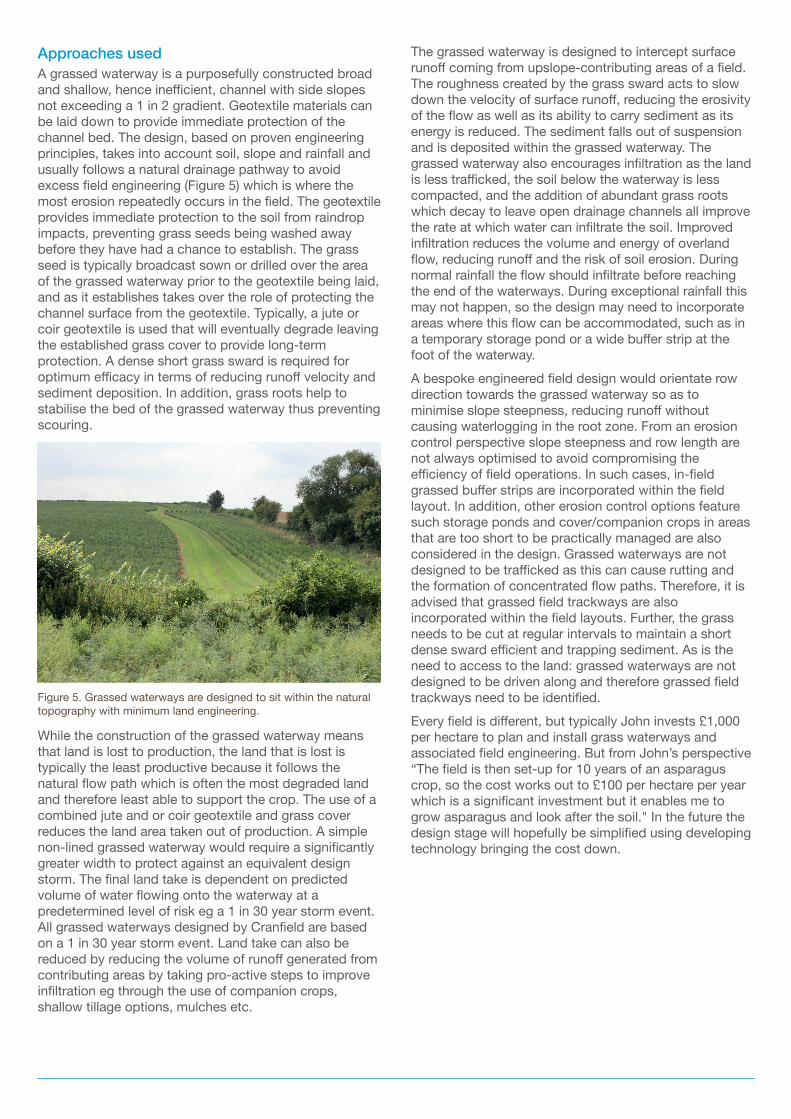
Approaches used A grassed waterway is a purposefully constructed broad and shallow, hence inefficient, channel with side slopes not exceeding a 1 in 2 gradient. Geotextile materials can be laid down to provide immediate protection of the channel bed. The design, based on proven engineering principles, takes into account soil, slope and rainfall and usually follows a natural drainage pathway to avoid excess field engineering (Figure 5) which is where the most erosion repeatedly occurs in the field. The geotextile provides immediate protection to the soil from raindrop impacts, preventing grass seeds being washed away before they have had a chance to establish. The grass seed is typically broadcast sown or drilled over the area of the grassed waterway prior to the geotextile being laid, and as it establishes takes over the role of protecting the channel surface from the geotextile. Typically, a jute or coir geotextile is used that will eventually degrade leaving the established grass cover to provide long-term protection. A dense short grass sward is required for optimum efficacy in terms of reducing runoff velocity and sediment deposition. In addition, grass roots help to stabilise the bed of the grassed waterway thus preventing scouring.
While the construction of the grassed waterway means that land is lost to production, the land that is lost is typically the least productive because it follows the natural flow path which is often the most degraded land and therefore least able to support the crop. The use of a combined jute and or coir geotextile and grass cover reduces the land area taken out of production. A simple non-lined grassed waterway would require a significantly greater width to protect against an equivalent design storm. The final land take is dependent on predicted volume of water flowing onto the waterway at a predetermined level of risk eg a 1 in 30 year storm event. All grassed waterways designed by Cranfield are based on a 1 in 30 year storm event. Land take can also be reduced by reducing the volume of runoff generated from contributing areas by taking pro-active steps to improve infiltration eg through the use of companion crops, shallow tillage options, mulches etc.
The grassed waterway is designed to intercept surface runoff coming from upslope-contributing areas of a field. The roughness created by the grass sward acts to slow down the velocity of surface runoff, reducing the erosivity of the flow as well as its ability to carry sediment as its energy is reduced. The sediment falls out of suspension and is deposited within the grassed waterway. The grassed waterway also encourages infiltration as the land is less trafficked, the soil below the waterway is less compacted, and the addition of abundant grass roots which decay to leave open drainage channels all improve the rate at which water can infiltrate the soil. Improved infiltration reduces the volume and energy of overland flow, reducing runoff and the risk of soil erosion. During normal rainfall the flow should infiltrate before reaching the end of the waterways. During exceptional rainfall this may not happen, so the design may need to incorporate areas where this flow can be accommodated, such as in a temporary storage pond or a wide buffer strip at the foot of the waterway. A bespoke engineered field design would orientate row direction towards the grassed waterway so as to minimise slope steepness, reducing runoff without causing waterlogging in the root zone. From an erosion control perspective slope steepness and row length are not always optimised to avoid compromising the efficiency of field operations. In such cases, in-field grassed buffer strips are incorporated within the field layout. In addition, other erosion control options feature such storage ponds and cover/companion crops in areas that are too short to be practically managed are also considered in the design. Grassed waterways are not designed to be trafficked as this can cause rutting and the formation of concentrated flow paths. Therefore, it is advised that grassed field trackways are also incorporated within the field layouts. Further, the grass needs to be cut at regular intervals to maintain a short dense sward efficient and trapping sediment. As is the need to access to the land: grassed waterways are not designed to be driven along and therefore grassed field trackways need to be identified. Every field is different, but typically John invests £1,000 per hectare to plan and install grass waterways and associated field engineering. But from John’s perspective “The field is then set-up for 10 years of an asparagus crop, so the cost works out to £100 per hectare per year which is a significant investment but it enables me to grow asparagus and look after the soil." In the future the design stage will hopefully be simplified using developing technology bringing the cost down.
Figure 5. Grassed waterways are designed to sit within the natural topography with minimum land engineering.

Want to know more?If you want more information about AHDB you can contact us in the following ways:
AHDB, Stoneleigh Park, Kenilworth, Warwickshire CV8 2TL T: 024 7669 2051 E: [email protected] Twitter: @TheAHDB
ahdb.org.uk
While the Agriculture and Horticulture Development Board seeks to ensure that the information contained within this document is accurate at the time of printing, no warranty is given in respect thereof and, to the maximum extent permitted by law, the Agriculture and Horticulture Development Board accepts no liability for loss, damage or injury howsoever caused (including that caused by negligence) or suffered directly or indirectly in relation to information and opinions contained in or omitted from this document.
Reference herein to trade names and proprietary products without stating that they are protected does not imply that they may be regarded as unprotected and thus free for general use. No endorsement of named products is intended, nor is any critcism implied of other alternative but unnamed products.
© Agriculture and Horticulture Development Board 2017. All rights reserved
AuthorsJohn Chinn – Cobrey FarmsRobert Simmons – Cranfield UniversityLynda Deeks - Cranfield University
Findings In John’s experience, the installation of grassed waterways has largely eliminated runoff from most fields and hugely reduced the problem from the rest. Further runoff generated under extreme rainfall events has lower levels of sediment due to deposition along the length of the grassed waterway. It has enabled land that was formally not capable of supporting asparagus to be used and substantially reduced the degradation of the land by soil erosion. While grassed waterways do not prevent soil erosion across the whole field area they do work to maintain the soil in the field.John's experience has given him a greater understanding of his farm's soils' and their impact on his business. Cobrey Farms is hosting trials on AHDB Horticulture Project FV 450 which was funded to understand the opportunity for cover crops and companion cropping to further reduce erosion risk in asparagus plantations.
References Natural England Technical Information Note TIN099 (2011). Protecting water from agricultural run-off: water retention measures. Accessed online at: http://www.riverneneregionalpark.org/publications/brochures-downloads/csf/protecting-water-from-agricultural-run-off-water-retention-measures.pdf
Acknowledgements All images are courtesy and copyright of Rob Simmons of Cranfield University
Further information Further resources to help you with soil management is available on the AHDB Greatsoils website: horticulture.ahdb.org.uk/greatsoils