Embed Size (px)
Citation preview
facebook.com/statisticssweden @SCB_nyheter
How Geospatial Statistics can measure climate change
Marie HaldorsonDirector
Regions & Environment Department

facebook.com/statisticssweden @SCB_nyheter
The Swedish Example

Georef. Register
data
Spatial data
Processing
Statistics
Cadastral mapFarm blocksLocalitiesNational Road databaseLand coverEtc
Population registerReal estate registerFarm registerOpen pit registerEtc
Creating Geospatial statistics

- David Svensson- 42 years- Married to Lisa- 2 children
- Works at a bank in Solna- Earns 43 000 Euro/year- Drives a Volvo V70
- Lives in a house with 9 775 sqm dwelling area.- 275 people live in the same house
100 meters to the closest health clinic
290 meters to the closest grocery store

- David Svensson- 42 years- Married to Lisa- 2 children
- Works at a bank in Solna- Earns 43 000 Euro/year- Drives a Volvo V70
- Lives in a house with 9 775 sqm dwelling area.- 275 people live in the same house
100 meters to the closest health clinic
290 meters to the closest grocery store
100 meters to the closest road

- David Svensson- 42 years- Married to Lisa- 2 children
- Jobbar på bank i Solna- Tjänar 430 000 om året- Kör Volvo V70
- Bor i fastighet taxerad som hyreshusenhet med bostäder och lokaler. 9 775 kvm bostadsyta.- 275 andra personer bor i fastigheten
100 meters to the closest health clinic
290 meters to the closest grocery store
Access to 2 hectares green area within 100 meters from home
100 meters to the closest road

- David Svensson- 42 years- Married to Lisa- 2 children
- Works at a bank in Solna- Earns 43 000 Euro/year- Drives a Volvo V70
- Lives in a house with 9 775 sqm dwelling area.- 275 people live in the same house
100 meters to the closest health clinic
290 meters to the closest grocery store
Access to 2 hectares green area within 100 meters from home
100 meters to the closest road
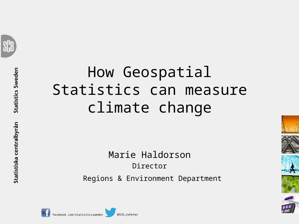
Acess to four alottments within 400 meters from home
- David Svensson- 42 years- Married to Lisa- 2 children
- Works at a bank in Solna- Earns 43 000 Euro/year- Drives a Volvo V70
- Lives in a house with 9 775 sqm dwelling area.- 275 people live in the same house
100 meters to the closest health clinic
290 meters to the closest grocery store
Access to 2 hectares green area within 100 meters from home
100 meters to the closest road
Acess to four alottments within 400 meters from home

The issue of disclosure

facebook.com/statisticssweden @SCB_nyheter
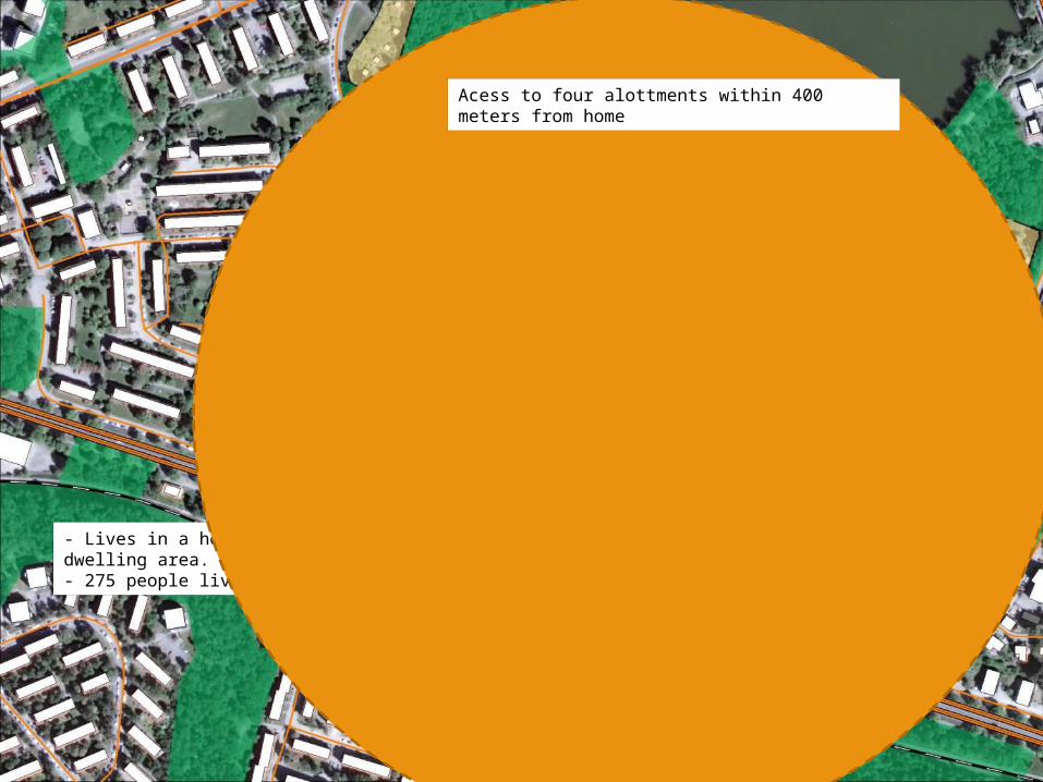
Developing a Statistical Spatial Framework
UN-GGIM & GEOSTAT2

User needs
Admin. & statistical boundaries
Addressing, Place Names
Transport, Water
Land and Property
Elevation and Depth
Imagery
Positioning
Foundation Spatial Data Frameworks – Fundamental Elements
Data layers:
NSS Socio-Economic Datasets
Land Valuation and Use
Immigration
Others …
Core Statistical
Census, Demographics, Agriculture, Building,
Labour Force, etc.
Tax
Income and Business Tax
Health
Medicare, Pharmaceuticals,
Workforce
Social WelfareUnemployment,
Disability, Family Support
SSF bridge
Statistical Community Spatial Community

Statistical Spatial Framework
Stati
stica
l Spa
tial Fr
amew
ork (
SSF)
Accessible & Usable
Interoperable metadata
Common geographic boundaries
Data management: geocoded unit record data
Authoritative geospatial infrastructure and geocoding


facebook.com/statisticssweden @SCB_nyheter
Institutional arrangements
UN-GGIM:Europe
INSPIRE
Swedish Geodata Cooperation

the Competitiveness and Innovation framework Programme (CIP)ICT Policy Support Programme (PSP) Call 6 Grant 325140 EUROPEAN LOCATION FRAMEWORK
Copyright ©2013 EuroGeographics
The first UN-GGIM:Europe report:
“Data Integration – Definition of priority user needs for combinations of data”
the Competitiveness and Innovation framework Programme (CIP)ICT Policy Support Programme (PSP) Call 6 Grant 325140 EUROPEAN LOCATION FRAMEWORK
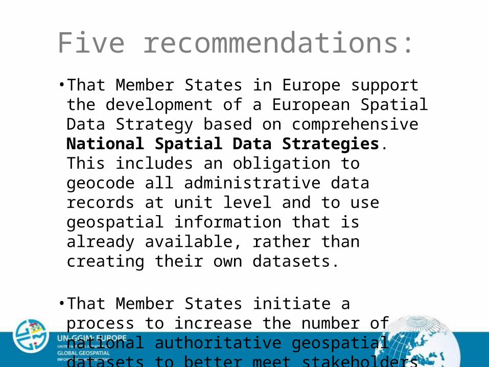
Five recommendations:• That Member States in Europe support the
development of a European Spatial Data Strategy based on comprehensive National Spatial Data Strategies. This includes an obligation to geocode all administrative data records at unit level and to use geospatial information that is already available, rather than creating their own datasets.
• That Member States initiate a process to increase the number of national authoritative geospatial datasets to better meet stakeholders requirements.

the Competitiveness and Innovation framework Programme (CIP)ICT Policy Support Programme (PSP) Call 6 Grant 325140 EUROPEAN LOCATION FRAMEWORK
Five recommendations:• That Member States consider the requirements of
National Statistical Institutes to provide geospatial information for following trends and changes in the environment.
• That Member States promote the use of geospatial workflows and technology as key to advancing the integration of geospatial and thematic information.
• That Member States promote the use of geospatial workflows and technology, in particular for the Census 2021.

The INSPIRE Directive The European INSPIRE Directive entered in force in
May 2007 and will be fully implemented by 2020.
An infrastructure for spatial information in Europe – supports environmental policies and policies or activities which may have an impact on the environment.
The Directive is implemented innational legislation.

27 Member States provide search, view and download services
34 Spatial data themes – both reference data and thematic data from different authorities

The Swedish Spatial Data Cooperation
Initiated by the European INSPIRE Directive
INSPIRE requires data sharing between public authorities
The parties access spatial data for official use at an annual fee
The Swedish Spatial Data Strategy gives the cooperation a broader scope than INSPIRE

Organisation f
Organisation d
Organisation e
Organisation gOrganisation a
Organisation b
Organisation c
Organisation d
Joint Agreement
onDatasharing
Organisation h
Before 2011and after…..
The Swedish Spatial Data Cooperation
facebook.com/statisticssweden @SCB_nyheter
The Power of Where

Potential impact of climate change (ESPON 2013 Programme – CLIMATE project)
Administrative Areas vs. Grids

Flooding – how to prepare
Example of GIS-application for calculation of consequences of a dam failure

Useful links UN-GGIM Global Expert Group UN-GGIM: Europe – Integration Statistics
/Geospatial GEOSTAT 1 & 2