Embed Size (px)
Citation preview
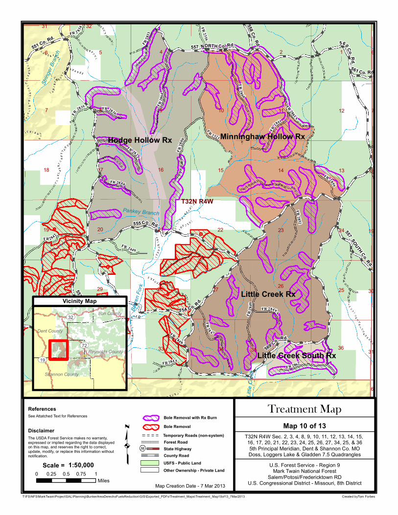
Little Creek Rx
Hodge Hollow Rx Minninghaw Hollow Rx
Little Creek South Rx
T32N R4W
98
145 23
7
6
11
20
12
13
24
32
26 25
23
14
22
36
17
29
15
33 35
10
2728
21
34
16
31
18
19
30
6
6
7
31
30
19
18
31 32
5 54 Co. Rd.
569 Co. Rd.
560 Co. Rd.
555 Co. Rd.
553 Co. R d.
557_NORTH Co. Rd.551 Co. Rd.
557_SOUTH Co. Rd.
558 Co. Rd.
561 Co. Rd.
F R 2321
FR 28
61
FR 28
49
FR 2842
FR 28 60FR
2864
F R 2862
FR 2821
FR 28 4 7
FR 28
00
F R 2449
FR 2840FR 2859
FR 2845
FR 2836
FR 2833
FR 2852
FR 2316
FR 2849A
FR 2 834
FR 284 8
FR
2835 FR 2861A
Barre
n Fork
Little
Cree
k
Gray Branch
String
er Bra
nch
Pankey Branch
Created byTom Forbes
q U.S. Forest Service - Region 9Mark Twain National Forest
Salem/Potosi/Fredericktown RDU.S. Congressional District - Missouri, 8th DistrictMap Creation Date - 7 Mar 2013
T32N R4W Sec. 2, 3, 4, 8, 9, 10, 11, 12, 13, 14, 15, 16, 17, 20, 21, 22, 23, 24, 25, 26, 27, 34, 25, & 365th Principal Meridian, Dent & Shannon Co. MODoss, Loggers Lake & Gladden 7.5 Quadrangles
The USDA Forest Service makes no warranty, expressed or implied regarding the data displayed on this map, and reserves the right to correct, update, modify, or replace this information without notification.
Disclaimer
ReferencesSee Attatched Text for References
T:\FS\NFS\MarkTwain\Project\SAL\Planning\BunkerAreaDerechoFuelsReduction\GIS\Exported_PDFs\Treatment_Maps\Treatment_Map10of13_7Mar2013
Map 10 of 13Treatment Map
0 0.25 0.5 0.75 1Miles
1:50,000Scale =
Dent County
Reynolds County
Shannon County
Iron County
UV72
UV32
UV19
Vicinity Map
State Highway32
Other Ownership - Private Land
County RoadUSFS - Public Land
Temporary Roads (non-system)Forest Road
Bole RemovalBole Removal with Rx Burn


![F ; > H M « > « J h f Z r d» e y g d R [ d b g k d h ] j Z ...romashkabel.ucoz.ru/2016/2018/2019/obrazovatelnaja... · F ; > H M « > _ « J h f Z r d» _ e y g d R _ [ _ d b g](https://img.pdfslide.us/doc/110x75/5f0ac6d67e708231d42d49b2/f-h-m-j-h-f-z-r-d-e-y-g-d-r-d-b-g-k-d-h-j-z-f-.jpg)


![Ø]!] ]d]S]c]>]+]...õ ? ] ]W] ? ] ]d]A]S? ø ? ø ? ]/]?]U Â Å ÚPÊ F·] ][] ]d? \ \ ]1]R]d]H0)? \ \ ]1]R]d]H0)? ]/]?]U Â Å? NPS ? ]=] ]]R]d? ]=] ]]R]d? >Ì]1]R]d]H0)? F·] ][]](https://img.pdfslide.us/doc/110x75/61110e3953be2656aa761151/-dsc-w-das-u-p-f.jpg)