Embed Size (px)
Citation preview
Extensional shear zones as imaged by reflection seismic lines:
the Larderello geothermal field (central Italy)
Andrea Brogia,*, Antonio Lazzarottoa, Domenico Liottab, Giorgio Ranallic
aDipartimento di Scienze della Terra, Universita di Siena, Via Laterina 8, Siena 53100, ItalybDipartimento di Geologia e Geofisica, Universita di Bari, Via Orabona 4, Bari 70125, Italy
cDepartment of Earth Sciences and Ottawa-Carleton Geoscience Centre, Carleton University, Ottawa, Canada K1S 5B6
Received 15 November 2001; accepted 27 November 2002
Abstract
The Larderello geothermal field is located in the Inner Northern Apennines, in an area which has been subject to extension
since the Early Miocene. The latest extensional episode (Pliocene–Present) has resulted in the formation of NW-trending, NE-
dipping listric normal faults, whose geometry is controlled down to f 3 km by borehole data. In this paper, we integrate a new
interpretation of seismic reflection lines with existing seismic, field, and borehole data to analyse the relations among listric
normal faults, the top of the brittle–ductile transition, and the migration of geothermal fluids.
In accordance with previous interpretations, we consider the strong reflector (K-horizon) marking the top of the reflective
mid-lower crust, and located at a depth of 3–5 km in the geothermal area, to represent the top of the brittle–ductile transition.
Its reflectivity most probably derives from the presence of overpressured fluids. We identify three main NW-trending, NE-
dipping extensional brittle shear zones, showing listric geometry and soling out in the vicinity of the K-horizon. The latter
appears to be dislocated in correspondence of the soling out of the shear zones. These shear zones, because of the associated
intense fracturing, represent the most natural channels of upward migration of geothermal fluids from the magmatic sources
located below the K-horizon.
We suggest that these two conclusions—that listric normal faults root at or near the brittle–ductile transition, and that they
act as preferential upward migration paths for magmatic fluids—may be of general validity for geothermal fields located in
extensional settings.
D 2002 Elsevier Science B.V. All rights reserved.
Keywords: Reflection seismology; Extensional tectonics; Larderello geothermal area
1. Introduction
Reflection seismic surveys have shown that
thinned continental crust is often characterized by
listric normal faults (Bally et al., 1981). Some listric
faults are restricted to the sedimentary cover whereas
others affect the basement rocks. In the latter case,
listric normal faults tend to flatten in the proximity of
the brittle–ductile transition (Shelton, 1984; Hamil-
ton, 1987). In principle, the brittle–ductile transition
is not detectable by means of seismic reflection
surveys. However, in those regions affected by exten-
sional tectonics and high surface heat flow, the high
0040-1951/02/$ - see front matter D 2002 Elsevier Science B.V. All rights reserved.
doi:10.1016/S0040-1951(02)00668-6
* Corresponding author. Fax: +39-5-772-33938.
E-mail address: [email protected] (A. Brogi).
www.elsevier.com/locate/tecto
Tectonophysics 363 (2003) 127–139
reflectivity of the middle– lower crust is usually
considered to be a consequence of its ductile behav-
iour during extension (Blundell, 1990 and references
therein). The top of the reflective zone is generally
located at about 6–7 s two-way travel time (hereafter:
TWT), corresponding to 15F 5 km (e.g., North Sea
province: Klemperer and Hobbs, 1991; Rhine Graben:
Mayer et al., 1997; Western United States: McCarthy
and Thompson, 1988; Inner Northern Apennines:
Decandia et al., 1998). The top of the reflective zone
tends to be shallower beneath regions with higher heat
flow (Klemperer, 1987). This trend parallels that of
the depth of the brittle–ductile transition, which
decreases with increasing geothermal gradient (Kusz-
nir and Park, 1987; Ranalli, 1995; Ranalli and Mur-
phy, 1987).
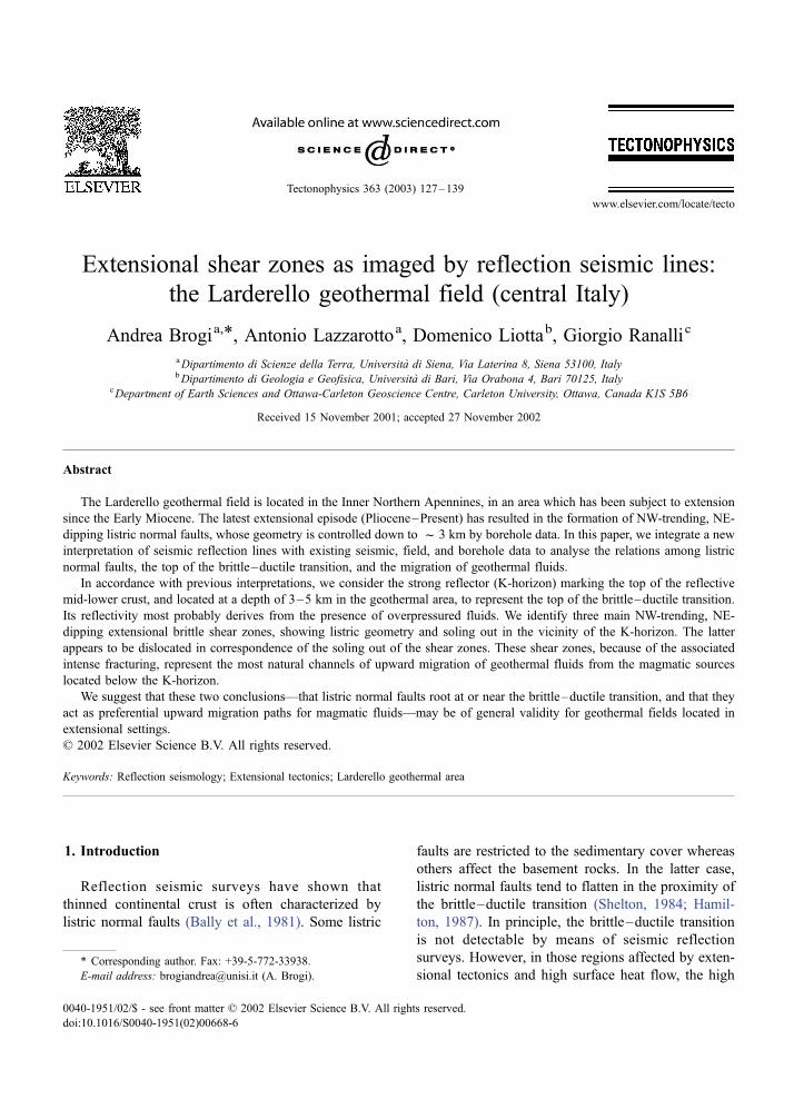
The Larderello geothermal area (Fig. 1) is located
in a structural high within the Inner Northern Apen-
nines, which have been affected by extension since
Early–Middle Miocene (Carmignani and Kligfield,
1990; Jolivet et al., 1990). Heat flow is very high
(120 mW/m2 as a regional average, with local peaks
up to 1000 mW/m2: Mongelli et al., 1989). The top of
the reflective mid-lower crust is marked by a strong
seismic reflector, named the K-horizon (Batini et al.,
1978), located from ca. 1.5 to 4 s TWT (Cameli et al.,
1998 and references therein), corresponding to about
3–6 km of depth (Batini et al., 1983, 1985). These
values are consistent with the expected depth of the
top of the brittle –ductile transition (Liotta and
Ranalli, 1999).
In this paper, we integrate field and borehole data
with a new interpretation of reflection seismic lines in
order to investigate the relationship between normal
faults and the top of the brittle–ductile transition in
the Larderello geothermal area. The results allow the
identification of three main extensional listric shear
zones, which sole out at or just below the K-horizon
and are associated with interruptions in its reflectivity.
These shear zones represent the most natural path-
ways for the upward migration of geothermal fluids of
deeper magmatic origin.
2. Geological framework
After the convergent and collisional stages (Late
Cretaceous–Early Miocene), which determined the
structural emplacement of the Northern Apennines
tectonic units, extensional tectonics (Miocene–
Present) affected the Inner Northern Apennines (De-
candia et al., 1998 and references therein). Collisional
and extensional processes are expressed in the struc-
ture of the Larderello geothermal field. A geological
map of the area is given in Fig. 2. Three regional
tectono-stratigraphic elements have been recognised
(Fig. 3): (1) Miocene–Pliocene and Quaternary sedi-
ments, filling extensional tectonic depressions and
unconformably overlying the substratum (e.g., the
Serrazzano and Pomarance Basins); (2) the Ligurian
Complex, composed of remnants of Jurassic oceanic
crust and its Cretaceous–Oligocene sedimentary
cover; this complex was thrust eastward over the
Tuscan Complex during Late Oligocene–Early Mio-
cene; and (3) the Tuscan Complex, including sedi-
mentary rocks ranging from Late Triassic evaporites
to Late Oligocene–Early Miocene turbidites.
The substratum of the sedimentary cover is mainly
known in the area through drilling of geothermal
wells, penetrating the crust down to about 3.5 km. It
is composed of two units (Bertini et al., 1991): the
upper Monticiano–Roccastrada Unit and the lower
Fig. 1. Simplified structural map of southern Tuscany showing the
main extensional structures, the ages of the main magmatic bodies,
and the Larderello geothermal area. Miocene and Pliocene transfer
zones correspond to transverse shear zones coeval with extensional
faults.
A. Brogi et al. / Tectonophysics 363 (2003) 127–139128
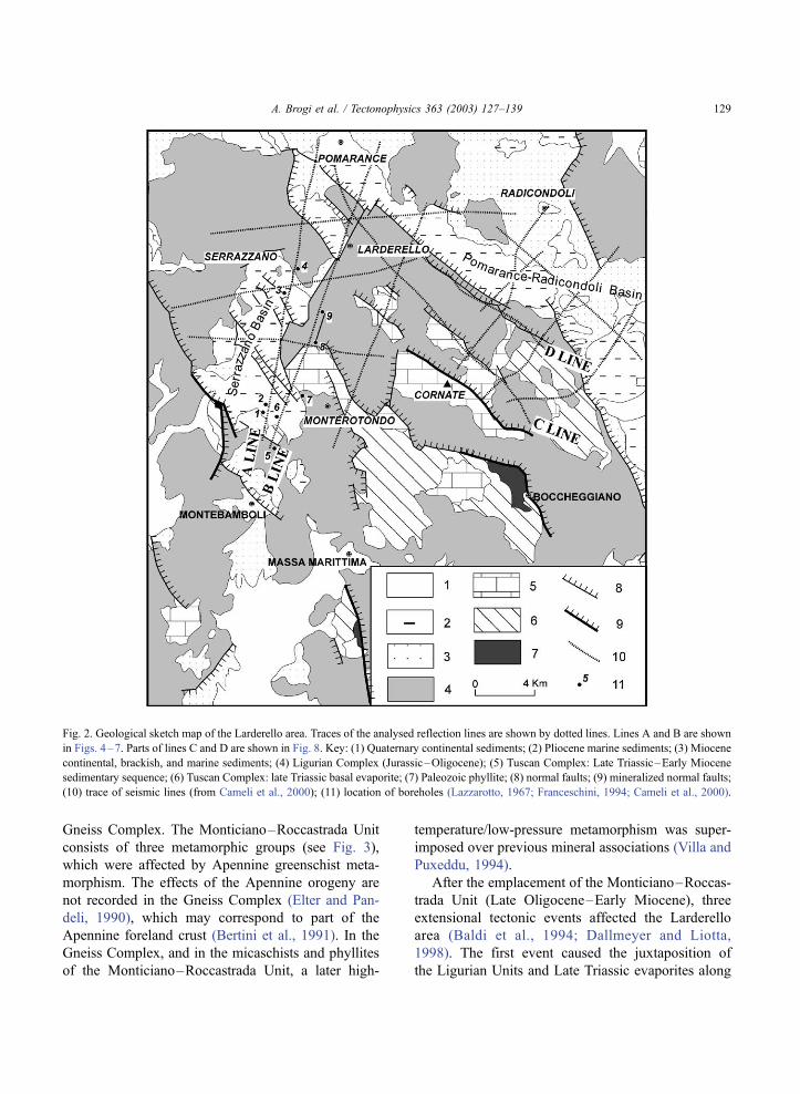
Gneiss Complex. The Monticiano–Roccastrada Unit
consists of three metamorphic groups (see Fig. 3),
which were affected by Apennine greenschist meta-
morphism. The effects of the Apennine orogeny are
not recorded in the Gneiss Complex (Elter and Pan-
deli, 1990), which may correspond to part of the
Apennine foreland crust (Bertini et al., 1991). In the
Gneiss Complex, and in the micaschists and phyllites
of the Monticiano–Roccastrada Unit, a later high-
temperature/low-pressure metamorphism was super-
imposed over previous mineral associations (Villa and
Puxeddu, 1994).
After the emplacement of the Monticiano–Roccas-
trada Unit (Late Oligocene–Early Miocene), three
extensional tectonic events affected the Larderello
area (Baldi et al., 1994; Dallmeyer and Liotta,
1998). The first event caused the juxtaposition of
the Ligurian Units and Late Triassic evaporites along
Fig. 2. Geological sketch map of the Larderello area. Traces of the analysed reflection lines are shown by dotted lines. Lines A and B are shown
in Figs. 4–7. Parts of lines C and D are shown in Fig. 8. Key: (1) Quaternary continental sediments; (2) Pliocene marine sediments; (3) Miocene
continental, brackish, and marine sediments; (4) Ligurian Complex (Jurassic–Oligocene); (5) Tuscan Complex: Late Triassic–Early Miocene
sedimentary sequence; (6) Tuscan Complex: late Triassic basal evaporite; (7) Paleozoic phyllite; (8) normal faults; (9) mineralized normal faults;
(10) trace of seismic lines (from Cameli et al., 2000); (11) location of boreholes (Lazzarotto, 1967; Franceschini, 1994; Cameli et al., 2000).
A. Brogi et al. / Tectonophysics 363 (2003) 127–139 129
low-angle normal faults (Lavecchia et al., 1984).
These faults root in the Late Triassic evaporites,
which are the main detachment level during this ex-
tensional event (Burdigalian–Langhian: Carmignani
et al., 1995; Brunet et al., 2000). The second exten-
sional event occurred between the Serravallian and the
late Messinian and was characterised by normal faults
sealed by Pliocene sediments (Mazzanti, 1967; Laz-
zarotto, 1967; Lazzarotto and Mazzanti, 1978). The
third extensional event was characterised by formation
of normal faults, which dissect Early–Middle Plio-
cene and Early Pleistocene sediments. These faults,
generally NW-striking and NE-dipping, bound crustal
blocks that have rotated southwestward (Baldi et al.,
1994).
The Inner Northern Apennines were affected by
widespread Late Miocene–Quaternary magmatism
(see Fig. 1) deriving from mixing of crustal and
mantle sources (Serri et al., 1993). In the Larderello
area, boreholes encounter felsic dykes and granitoids
at different depths, ranging in age between 3.8 and
2.25 Ma (Gianelli and Laurenzi, 2001). Magmatic
fluids from these granitoids are considered to be the
agents of the hydrothermal mineralization character-
ising many deep borehole samples (Gianelli, 1994).
Information on deeper structural levels derives
from seismic reflection lines acquired for exploration
for geothermal energy. The seismic lines show a clear
distinction between a poorly reflective upper and a
highly reflective mid-lower crust (Cameli et al.,
1993). The top of the reflective crust is marked by
a discontinuous reflector of high amplitude, referred
to as the K-horizon (Batini et al., 1978), which has
local bright spot features (Batini et al., 1985). These
seismic features are also shown in regional reflection
lines acquired for the study of the Northern Apen-
nines deep crust (Pialli et al., 1998). The K-horizon,
located regionally at a depth of f 8–10 km, shows a
culmination in the Larderello area and appears to be
related to a critical temperature (Liotta and Ranalli,
1999).
3. Analysis of the reflection seismic lines
In order to elucidate the geometry and the signifi-
cance of the Pliocene–Present normal faults (latest
extensional episode) and their relationship with the
present brittle–ductile transition, several reflection
seismic lines, acquired during the last 30 years for
exploration purposes, were analysed (see location in
Fig. 2). Their orientation and distribution allow us to
investigate the entire geothermal area. Parameters for
data acquisition and processing are described in Batini
et al. (1978, 1985) and Cameli (1994). In the Larder-
ello area, the surface geology is well known (Co-
stantini, 2002; Sandrelli, 2002) and the borehole
control is high (about 3 boreholes/km2). The abun-
dance of field and borehole data controls the geometry
of geological bodies and structures from the surface
down to about 3 km (c 1 s TWT). Our interpretation
between 1 and 3 s TWT (i.e., the K-horizon depth
range) is thus aided by the better-controlled upper
part.
In the following subsections, the geological inter-
pretation of two SSW–NNE migrated reflections lines
(lines A and B in Fig. 2) is described. These lines are
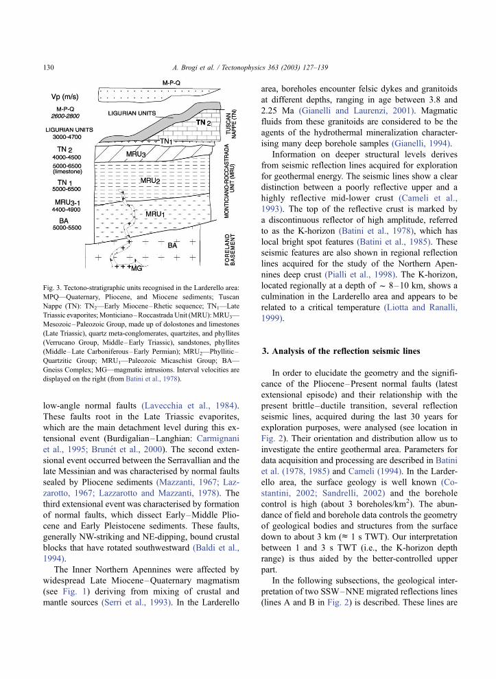
Fig. 3. Tectono-stratigraphic units recognised in the Larderello area:
MPQ—Quaternary, Pliocene, and Miocene sediments; Tuscan
Nappe (TN): TN2—Early Miocene–Rhetic sequence; TN1—Late
Triassic evaporites;Monticiano–Roccastrada Unit (MRU):MRU3—
Mesozoic–Paleozoic Group, made up of dolostones and limestones
(Late Triassic), quartz meta-conglomerates, quartzites, and phyllites
(Verrucano Group, Middle–Early Triassic), sandstones, phyllites
(Middle–Late Carboniferous–Early Permian); MRU2—Phyllitic–
Quartzitic Group; MRU1—Paleozoic Micaschist Group; BA—
Gneiss Complex; MG—magmatic intrusions. Interval velocities are
displayed on the right (from Batini et al., 1978).
A. Brogi et al. / Tectonophysics 363 (2003) 127–139130
considered among the most significant— among the
many we have analysed—to image the upper crustal
features of the Larderello geothermal area. Conver-
sion from time to depth has been based on vertical
seismic profiles (well logs) and on P-velocity and S-
velocity measurements (Batini and Nicolich, 1985;
Batini et al., 1978; Tarquini et al., 1995; see Fig. 3 for
interval velocities). As a check on the proposed
interpretation, two lines parallel to the strike of sur-
face normal faults (lines C and D in Fig. 2) are also
examined.
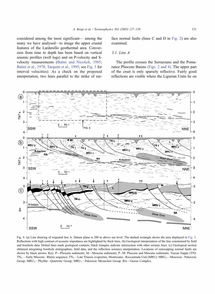
3.1. Line A
The profile crosses the Serrazzano and the Poma-
rance Pliocene Basins (Figs. 2 and 4). The upper part
of the crust is only sparsely reflective. Fairly good
reflections are visible where the Ligurian Units lie on
Fig. 4. (a) Line drawing of migrated line A. Datum plane is 200 m above sea level. The dashed rectangle shows the area displayed in Fig. 5.
Reflections with high contrast of acoustic impedance are highlighted by thick lines. (b) Geological interpretation of the line constrained by field
and borehole data. Dotted lines mark geological contacts; black triangles indicate intersection with other seismic lines. (c) Geological section
obtained integrating borehole stratigraphies, field data, and the reflection seismics interpretation. Locations of outcropping normal faults are
shown by black arrows. Key: P—Pliocene sediments; M—Miocene sediments; P–M: Pliocene and Miocene sediments; Tuscan Nappe (TN):
TN2 —Early Miocene–Rhetic sequence; TN1—Late Triassic evaporites; Monticiano–Roccastrada Unit (MRU): MRU3—Mesozoic–Paleozoic
Group; MRU2—Phyllite–Quartzitic Group; MRU1—Paleozoic Micaschist Group; BA—Gneiss Complex.
A. Brogi et al. / Tectonophysics 363 (2003) 127–139 131
the Late Triassic evaporites and on the carbonate
sequence of the Tuscan Nappe. Also the Verrucano
Group is characterised by a good reflectivity deriving
from its duplex structure (Bertini et al., 1994). The
line crosses NE-dipping listric normal faults related to
the third extensional event. The geometry of these
faults is well constrained by borehole and field data
from the surface down to about 1 s TWT. The
reflectivity of some of these faults is defined by weak
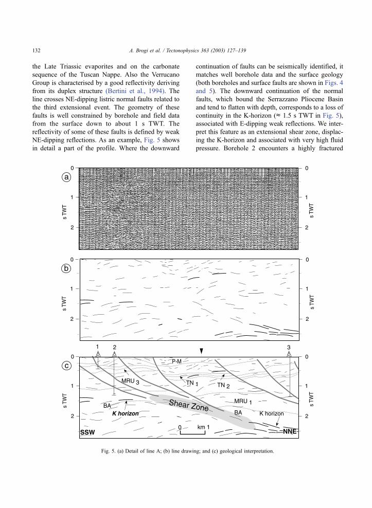
NE-dipping reflections. As an example, Fig. 5 shows
in detail a part of the profile. Where the downward
continuation of faults can be seismically identified, it
matches well borehole data and the surface geology
(both boreholes and surface faults are shown in Figs. 4
and 5). The downward continuation of the normal
faults, which bound the Serrazzano Pliocene Basin
and tend to flatten with depth, corresponds to a loss of
continuity in the K-horizon (c 1.5 s TWT in Fig. 5),
associated with E-dipping weak reflections. We inter-
pret this feature as an extensional shear zone, displac-
ing the K-horizon and associated with very high fluid
pressure. Borehole 2 encounters a highly fractured
Fig. 5. (a) Detail of line A; (b) line drawing; and (c) geological interpretation.
A. Brogi et al. / Tectonophysics 363 (2003) 127–139132
level, rich in hydrothermal minerals up to complete
replacement of the original rock, at c 2200 m.
Hydrothermal and contact metamorphism minerals
were found in the bottomhole samples at 2930 m
depth (Batini et al., 1985). An extremely high fluid
pressure caused the blow-up of this borehole (Batini et
al., 1985). In the central part of the section, the K-
horizon becomes deeper (c 2.2 s TWT), assuming a
clear bright spot feature (Batini et al., 1985), and a
lozenge-shaped geometry characterises the reflectivity
below it (Cameli et al., 1993). In the northern part of
the section, weak reflections, gently dipping NE, are
imaged above the K-horizon. These reflections are
related to the normal faults of the central part of the
Serrazzano Basin, coalescing in a northernmost shear
zone.
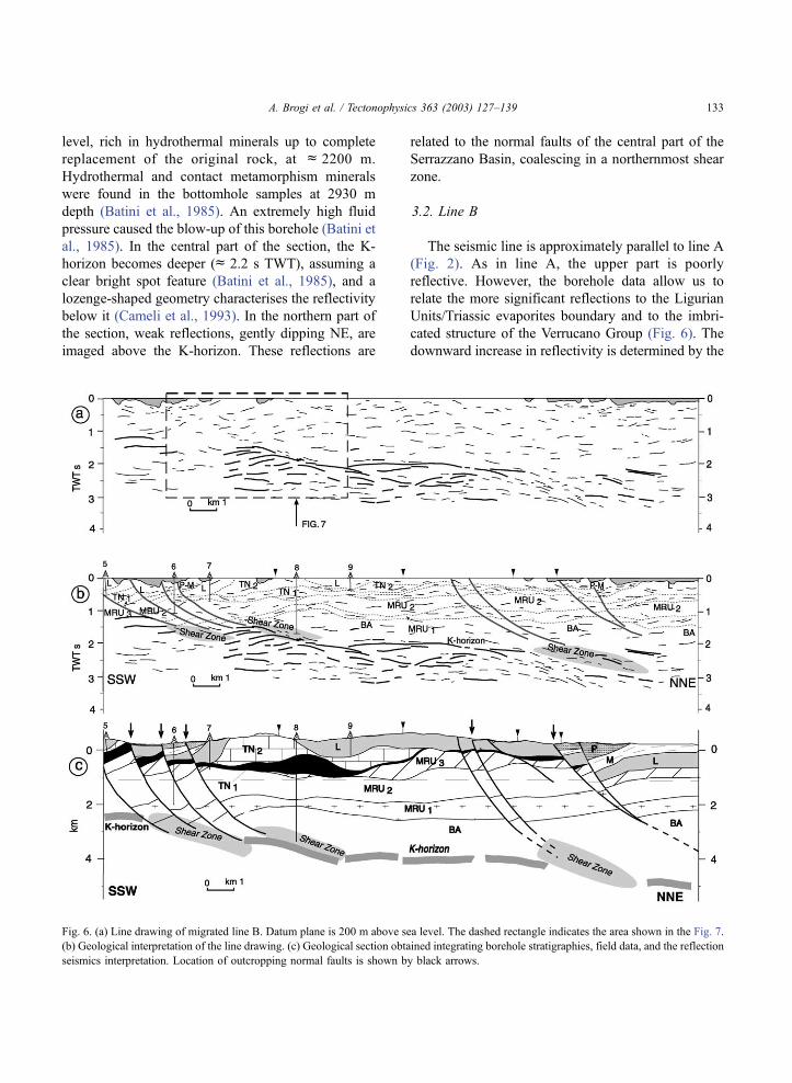
3.2. Line B
The seismic line is approximately parallel to line A
(Fig. 2). As in line A, the upper part is poorly
reflective. However, the borehole data allow us to
relate the more significant reflections to the Ligurian
Units/Triassic evaporites boundary and to the imbri-
cated structure of the Verrucano Group (Fig. 6). The
downward increase in reflectivity is determined by the
Fig. 6. (a) Line drawing of migrated line B. Datum plane is 200 m above sea level. The dashed rectangle indicates the area shown in the Fig. 7.
(b) Geological interpretation of the line drawing. (c) Geological section obtained integrating borehole stratigraphies, field data, and the reflection
seismics interpretation. Location of outcropping normal faults is shown by black arrows.
A. Brogi et al. / Tectonophysics 363 (2003) 127–139 133
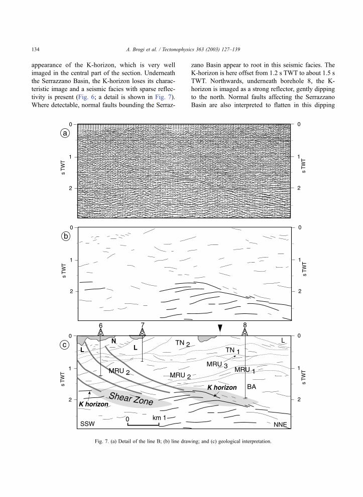
appearance of the K-horizon, which is very well
imaged in the central part of the section. Underneath
the Serrazzano Basin, the K-horizon loses its charac-
teristic image and a seismic facies with sparse reflec-
tivity is present (Fig. 6; a detail is shown in Fig. 7).
Where detectable, normal faults bounding the Serraz-
zano Basin appear to root in this seismic facies. The
K-horizon is here offset from 1.2 s TWT to about 1.5 s
TWT. Northwards, underneath borehole 8, the K-
horizon is imaged as a strong reflector, gently dipping
to the north. Normal faults affecting the Serrazzano
Basin are also interpreted to flatten in this dipping
Fig. 7. (a) Detail of the line B; (b) line drawing; and (c) geological interpretation.
A. Brogi et al. / Tectonophysics 363 (2003) 127–139134
reflector. Borehole 8 encounters fractured skarn rocks
at bottomhole depth (around 3400 m; Gianelli, 1994).
In the central part of the section, the K-horizon is
deeper (about 2.0 s TWTc 5 km depth; Fig. 7). In the
northeasternmost part of the line, the K-horizon and
the reflections beneath lose their lateral continuity,
and a seismic facies characterised by sparse reflec-
tions is again imaged. The normal faults of the
Pomarance–Radicondoli Basin are interpreted to sole
out here, in an extensional shear zone similar to the
one discussed in line A.
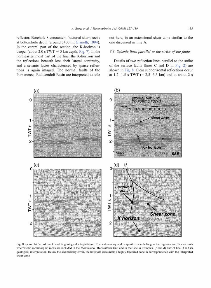
3.3. Seismic lines parallel to the strike of the faults
Details of two reflection lines parallel to the strike
of the surface faults (lines C and D in Fig. 2) are
shown in Fig. 8. Clear subhorizontal reflections occur
at 1.2–1.5 s TWT (c 2.5–3.3 km) and at about 2 s
Fig. 8. (a and b) Part of line C and its geological interpretation. The sedimentary and evaporitic rocks belong to the Ligurian and Tuscan units
whereas the metamorphic rocks are included in the Monticiano–Roccastrada Unit and in the Gneiss Complex. (c and d) Part of line D and its
geological interpretation. Below the sedimentary cover, the borehole encounters a highly fractured zone in correspondence with the interpreted
shear zone.
A. Brogi et al. / Tectonophysics 363 (2003) 127–139 135
TWT (c 5 km). The deeper ones are interpreted as the
K-horizon while those at 1.2–1.5 s TWT correspond
to the expected depth of the intersection of the exten-
sional shear zones with the strike-parallel seismic
lines.
4. Discussion and conclusions
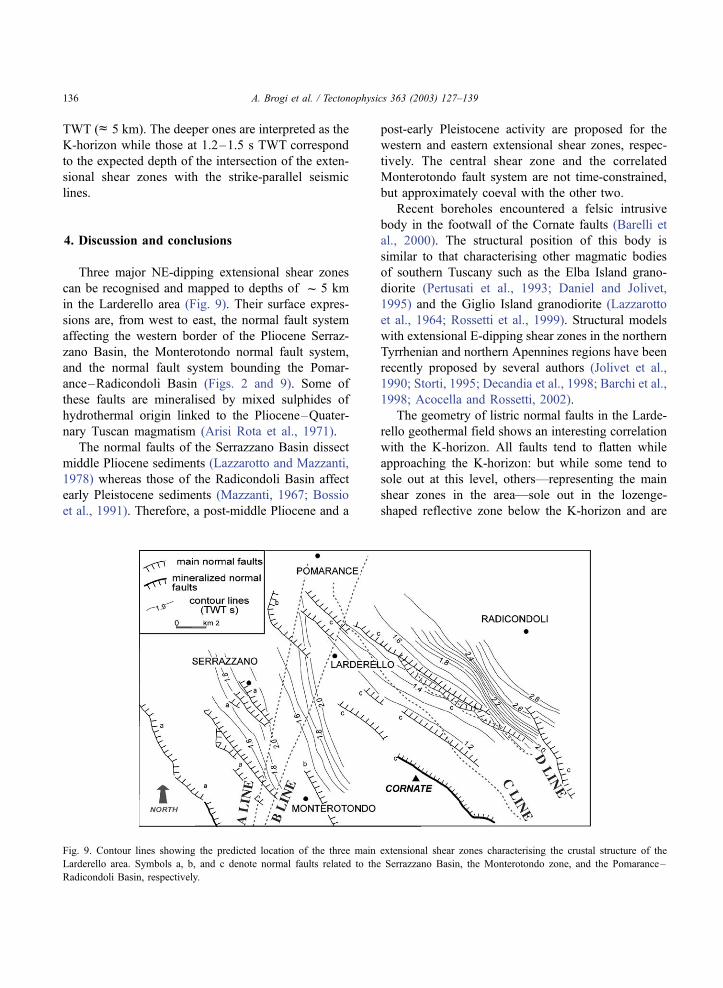
Three major NE-dipping extensional shear zones
can be recognised and mapped to depths of f 5 km
in the Larderello area (Fig. 9). Their surface expres-
sions are, from west to east, the normal fault system
affecting the western border of the Pliocene Serraz-
zano Basin, the Monterotondo normal fault system,
and the normal fault system bounding the Pomar-
ance–Radicondoli Basin (Figs. 2 and 9). Some of
these faults are mineralised by mixed sulphides of
hydrothermal origin linked to the Pliocene–Quater-
nary Tuscan magmatism (Arisi Rota et al., 1971).
The normal faults of the Serrazzano Basin dissect
middle Pliocene sediments (Lazzarotto and Mazzanti,
1978) whereas those of the Radicondoli Basin affect
early Pleistocene sediments (Mazzanti, 1967; Bossio
et al., 1991). Therefore, a post-middle Pliocene and a
post-early Pleistocene activity are proposed for the
western and eastern extensional shear zones, respec-
tively. The central shear zone and the correlated
Monterotondo fault system are not time-constrained,
but approximately coeval with the other two.
Recent boreholes encountered a felsic intrusive
body in the footwall of the Cornate faults (Barelli et
al., 2000). The structural position of this body is
similar to that characterising other magmatic bodies
of southern Tuscany such as the Elba Island grano-
diorite (Pertusati et al., 1993; Daniel and Jolivet,
1995) and the Giglio Island granodiorite (Lazzarotto
et al., 1964; Rossetti et al., 1999). Structural models
with extensional E-dipping shear zones in the northern
Tyrrhenian and northern Apennines regions have been
recently proposed by several authors (Jolivet et al.,
1990; Storti, 1995; Decandia et al., 1998; Barchi et al.,
1998; Acocella and Rossetti, 2002).
The geometry of listric normal faults in the Larde-
rello geothermal field shows an interesting correlation
with the K-horizon. All faults tend to flatten while
approaching the K-horizon: but while some tend to
sole out at this level, others—representing the main
shear zones in the area—sole out in the lozenge-
shaped reflective zone below the K-horizon and are
Fig. 9. Contour lines showing the predicted location of the three main extensional shear zones characterising the crustal structure of the
Larderello area. Symbols a, b, and c denote normal faults related to the Serrazzano Basin, the Monterotondo zone, and the Pomarance–
Radicondoli Basin, respectively.
A. Brogi et al. / Tectonophysics 363 (2003) 127–139136
associated with an apparent dislocation (change of
depth) of the K-horizon and local loss of reflectivity.
These differences derive from the transitional nature
of the brittle–ductile transition. The origin of the
reflectivity at the K-horizon and in the zone below
has been discussed by several authors (see Gianelli et
al., 1997 for a review). The occurrence of fluids can
explain the observed high contrast in acoustic impe-
dance (Batini and Nicolich, 1985; Batini et al., 1978,
1983; Cameli et al., 1993; Gianelli et al., 1997; Liotta
and Ranalli, 1999). The nature of these fluids is a
matter of speculation. Analyses of present-day geo-
thermal fluids suggest that they are originated from
mixing among dominant meteoric waters, products of
water–rocks interaction, and fluids from deep mag-
mas (Panichi et al., 1974; D’Amore and Bolognesi,
1994; Gianelli and Calore, 1996; Manzella et al.,
1998).
If fluids are associated with the K-horizon, the
local loss of reflectivity could be connected to the
absence of fluids, which have migrated towards shal-
lower levels along the shear zones identified in this
paper. In this hypothesis, the K-horizon would be the
‘‘roof’’ of the level with very high fluid pressure, and
the extensional shear zones would be the ‘‘way of
escape’’ of fluids toward shallower levels.
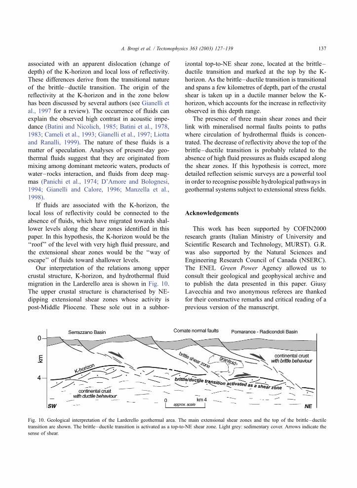
Our interpretation of the relations among upper
crustal structure, K-horizon, and hydrothermal fluid
migration in the Larderello area is shown in Fig. 10.
The upper crustal structure is characterised by NE-
dipping extensional shear zones whose activity is
post-Middle Pliocene. These sole out in a subhor-
izontal top-to-NE shear zone, located at the brittle–
ductile transition and marked at the top by the K-
horizon. As the brittle–ductile transition is transitional
and spans a few kilometres of depth, part of the crustal
shear is taken up in a ductile manner below the K-
horizon, which accounts for the increase in reflectivity
observed in this depth range.
The presence of three main shear zones and their
link with mineralised normal faults points to paths
where circulation of hydrothermal fluids is concen-
trated. The decrease of reflectivity above the top of the
brittle–ductile transition is probably related to the
absence of high fluid pressures as fluids escaped along
the shear zones. If this hypothesis is correct, more
detailed reflection seismic surveys are a powerful tool
in order to recognise possible hydrological pathways in
geothermal systems subject to extensional stress fields.
Acknowledgements
This work has been supported by COFIN2000
research grants (Italian Ministry of University and
Scientific Research and Technology, MURST). G.R.
was also supported by the Natural Sciences and
Engineering Research Council of Canada (NSERC).
The ENEL Green Power Agency allowed us to
consult their geological and geophysical archive and
to publish the data presented in this paper. Giusy
Lavecchia and two anonymous referees are thanked
for their constructive remarks and critical reading of a
previous version of the manuscript.
Fig. 10. Geological interpretation of the Larderello geothermal area. The main extensional shear zones and the top of the brittle–ductile
transition are shown. The brittle–ductile transition is activated as a top-to-NE shear zone. Light grey: sedimentary cover. Arrows indicate the
sense of shear.
A. Brogi et al. / Tectonophysics 363 (2003) 127–139 137
References
Acocella, V., Rossetti, F., 2002. The role of extensional tectonics at
different crustal levels on granite ascent and emplacement: an
example from Tuscany (Italy). Tectonophysics 354, 71–83.
Arisi Rota, F., Brondi, A., Dessau, G., Franzini, M., Monte Amiata,
S.P.A., del Sele, S.M., Stea, B., Vighi, L., 1971. I Giacimenti
minerari. Rend. Soc. Ital. Mineral. Petrol. 27, 357–544.
Baldi, P., Bertini, G., Cameli, G.M., Decandia, F.A., Dini, I., Laz-
zarotto, A., Liotta, D., 1994. La tettonica distensiva post-colli-
sionale nell’area geotermica di Larderello (Toscana meridio-
nale). Studi Geol. Camerti 1, 183–193.
Bally, A.W., Bernoulli, D., Davis, G.A., Montadert, L., 1981. Lis-
tric normal faults. Oceanologica Acta, No Sp., Proceedings
26af4th International Geological Congress, Geology of Continen-
tal Margin Symposium, Paris, July 7–17, 1980, pp. 87–101.
Barchi, M., Minelli, G., Pialli, G., 1998. The CROP 03 profile: a
synthesis of results on deep structures of the Northern Apen-
nines. Mem. Soc. Geol. Ital. 52, 383–400.
Barelli, A., Bertini, G., Buonasorte, G., Capetti, G., Fiordelisi, A.,
2000. Recent deep exploration results at the margins of the
Larderello Travale geothermal system. Proceedings World Geo-
thermal Congress 2000, Kyushu, Tohoku, Japan, May 28–June
10, pp. 965–970.
Batini, F., Nicolich, R., 1985. P and S reflection seismic profiling
and well logging in the Travale geothermal field. Geothermics
14, 731–747.
Batini, F., Burgassi, P.D., Cameli, G.M., Nicolich, R., Squarci, P.,
1978. Contribution to the study of the deep lithospheric profiles:
deep reflecting horizons in Larderello-Travale Geothermal field.
Mem. Soc. Geol. Ital. 19, 477–484.
Batini, F., Bertini, G., Giannelli, G., Pandeli, E., Puxeddu, M.,
1983. Deep structure of the Larderello geothermal field: contri-
bution from recent geophysical and geological data. Mem. Soc.
Geol. Ital. 5, 219–235.
Batini, F., Bertini, G., Giannelli, G., Pandeli, E., Puxeddu, M.,
Villa, I., 1985. Deep structure, age and evolution of the Larder-
ello-Travale geothermal field. Geotherm. Res., Commun. Trans.
9, 1–7.
Bertini, G., Cameli, G.M., Costantini, A., Decandia, F.A., Di Filip-
po, M., Dini, I., Elter, F.M., Lazzarotto, A., Liotta, D., Pandeli,
E., Sandrelli, F., Toro, B., 1991. Struttura geologica fra i monti
di Campiglia e Rapolano Terme (Toscana meridionale): stato
attuale delle conoscenze e problematiche. Studi Geol. Camerti
1, 155–178.
Bertini, G., Bertozzi, A., Dini, I., Santini, M., Tosi, F., Valenti, P.,
1994. Sondaggio stratigrafico Massa 2. Studi Geol. Camerti 1,
93–96.
Blundell, D.J., 1990. Seismic images of continental lithosphere.
J. Geol. Soc. (Lond.) 147, 895–913.
Bossio, A., Mazzanti, R., Mazzei, R., Salvatorini, G., Sandrelli, F.,
1991. Il Pliocene dell’area di Pomarance (Pisa). Atti Soc. Tosc.
Nat. Mem. 98, 1–98.
Brunet, C., Monie, P., Jolivet, L., Cadet, J.P., 2000. Migration of
compression and extension in the Tyrrhenian Sea, insights from40Ar/39Ar ages on micas along a transect from Corsica to Tus-
cany. Tectonophysics 321, 127–155.
Cameli, G.M., 1994. Indagine sulla tecnica di acquisizione sismica
della linea CROP 18. Studi Geol. Camerti 1, 13–17.
Cameli, G.M., Dini, I., Liotta, D., 1993. Upper crustal structure of
the Larderello geothermal field as a feature of post-collisional
extensional tectonics (Southern Tuscany, Italy). Tectonophysics
224, 413–423.
Cameli, G.M., Dini, I., Liotta, D., 1998. Brittle/ductile boundary
from seismic reflection lines of southern Tuscany (Northern
Apennines, Italy). Mem. Soc. Geol. Ital. 52, 153–163.
Cameli, G.M., Ceccarelli, A., Dini, I., Mazzotti, A., 2000. Contri-
bution of the seismic reflection method to the location of deep
fractured levels in the geothermal fields of Southern Tuscany
(central Italy). Proceedings World Geothermal Congress 2000,
Kyushu, Tohoku, Japan, May 28–June 10, pp. 1025–1029.
Carmignani, L., Kligfield, R., 1990. Crustal extension in the north-
ern Apennines: the transition from compression to extension in
the Alpi Apuane core complex. Tectonics 9, 1275–1303.
Carmignani, L., Decandia, F.A., Disperati, L., Fantozzi, P.L., Laz-
zarotto, A., Liotta, D., Oggiano, G., 1995. Relationships be-
tween the Sardinia–Corsica–Provenc�al Domain and the North-
ern Apennines. Terranova 7, 128–137.
Costantini, A. (Ed.), 2002. Foglio 306—Massa Marittima. Carta
Geologica d’Italia 1:50000. Servizio Geologico Italiano, Rome.
Dallmeyer, R.D., Liotta, D., 1998. Extension, uplift of rocks and
cooling ages in thinned crustal provinces: the Larderello geo-
thermal area (Inner Northern Apennines, Italy). Geol. Mag. 135,
193–202.
D’Amore, F., Bolognesi, L., 1994. Isotopic evidence for a magmatic
contribution to the fluids of the geothermal systems of the Lar-
derello and the Geysers. Geothermics 23, 21–32.
Daniel, J.M., Jolivet, L., 1995. Detachment faults and pluton em-
placement: Elba Island (Tyrrhenian Sea). Bull. Soc. Geol. Fr.
166, 341–354.
Decandia, F.A., Lazzarotto, A., Liotta, D., Cernobori, L., Nicolich,
R., 1998. The Crop 03 traverse: insights on post-collisional
evolution of northern Apennines. Mem. Soc. Geol. Ital. 52,
427–439.
Elter, F.M., Pandeli, E., 1990. Alpine and Hercynian orogenic
phases in the basement rocks of the Northern Apennines (Lar-
derello geothermal field, Southern Tuscany, Italy). Eclogae
Geol. Helv. 83, 241–264.
Franceschini, F., 1994. ‘‘Larderello plutono-metamorphic core com-
plex’’: metamorfismo regionale ercinico di bassa pressione o
metamorfismo di contatto plio-quaternario? Studi Geol. Camerti
1, 113–128.
Gianelli, G., 1994. Ipotesi di un modello di crosta superiore per le
aree geotermiche toscane. Studi Geol. Camerti 1, 195–200.
Gianelli, G., Calore, C., 1996. Models for the origin of carbon
dioxide in the Larderello geothermal field. Boll. Soc. Geol. It.
115, 75–84.
Gianelli, G., Laurenzi, M.A., 2001. Age and cooling rate of the
geothermal system of Larderello. Geotherm. Resour. Counc.
Trans. 25, 731–735.
Gianelli, G., Manzella, A., Puxeddu, M., 1997. Crustal models of
the geothermal areas of Southern Tuscany. Tectonophysics 281,
221–239.
Hamilton, W., 1987. Crustal extension in Basin and Range Prov-
A. Brogi et al. / Tectonophysics 363 (2003) 127–139138

ince, southwestern United States. In: Coward, M.P., et al. (Eds.),
Continental Extensional Tectonics. Geol. Soc. Spec. Publ., vol.
28, pp. 155–176.
Jolivet, L., Dubois, R., Fournier, M., Goffe, B., Michard, A., Jour-
dan, C., 1990. Ductile extension in the Alpine Corsica. Geology
18, 1007–1010.
Klemperer, S., 1987. A relation between continental heat flow and
the seismic reflectivity of the lower crust. J. Geophys. 61, 1–11.
Klemperer, S., Hobbs, R., 1991. The BIRPS Atlas. Cambridge
Univ. Press, Cambridge.
Kusznir, N.J., Park, R.G., 1987. The extensional strength of the
continental lithosphere: its dependence on geothermal gradient,
and crustal composition and thickness. In: Coward, R.G., et al.
(Eds.), Continental Extensional Tectonics. Geol. Soc. Spec.
Publ., vol. 28, pp. 35–52.
Lavecchia, G., Minelli, G., Pialli, G., 1984. L’ Appennino umbro-
marchigiano: tettonica distensiva ed ipotesi di sismogenesi.
Boll. Soc. Geol. Ital. 103, 467–476.
Lazzarotto, A., 1967. Geologia della zona compresa fra l’ alta Valle
del Fiume Cornia ed il Torrente Pavone (Prov. di Pisa e Gros-
seto). Mem. Soc. Geol. Ital. 6, 151–197.
Lazzarotto, A., Mazzanti, R., 1978. Geologia dell’ alta Val di Ce-
cina. Boll. Soc. Geol. Ital. 95, 1365–1487.
Lazzarotto, A., Mazzanti, R., Mazzoncini, F., 1964. Geologia del
promontorio Argentario (Grosseto) e del promontorio del Fran-
co (Isola del Giglio-Grosseto). Boll. Soc. Geol. Ital. 83, 1–125.
Liotta, D., Ranalli, G., 1999. Correlation between seismic reflectiv-
ity and rheology in extended lithosphere: southern Tuscany,
Inner Northern Apennines, Italy. Tectonophysics 315, 109–122.
Manzella, A., Ruggieri, G., Gianelli, G., Puxeddu, M., 1998. Plu-
tonic-geothermal systems of southern Tuscany: a review of the
crustal models. Mem. Soc. Geol. It. 52, 283–294.
Mayer, G., Mai, P.M., Plenefisch, T., Echtler, H., Luschen, E.,
Wehrle, V., Muller, B., Bonjer, K.P., Prodehl, C., Fuchs, K.,
1997. The deep crust of the Southern Rhine Graben: reflectivity
and seismicity as images of dynamic processes. Tectonophysics
275, 15–40.
Mazzanti, R., 1967. Geologia della zona di Pomarance-Larderello
(Prov. di Pisa). Mem. Soc. Geol. Ital. 5, 105–138.
McCarthy, J., Thompson, G.A., 1988. Seismic imaging of extended
crust with emphasis on the western United States. Geol. Soc.
Am. Bull. 100, 1361–1374.
Mongelli, F., Zito, G., Ciaranfi, N., Pieri, P., 1989. Interpretation of
heat flow density of the Apennine chain, Italy. Tectonophysics
164, 267–280.
Panichi, C., Celati, R., Noto, P., Squarci, P., Taffi, L., Tongiorgi, E.,
1974. Oxygen and hydrogen isotope studies of the Larderello
(Italy) geothermal system. Isotope Techniques in Groundwater
Hydrology. Int. Atomic Energy Agency (SM-182/27) 2, 3–28.
Pertusati, P., Raggi, G., Ricci, C.A., Duranti, S., Palmeri, R., 1993.
Evoluzione post-collisionale dell’Elba centro-orientale. Mem.
Soc. Geol. Ital. 49, 297–312.
Pialli, G.P., Barchi, G., Minelli, G. (Eds.), 1998. Results of the Crop
03 deep seismic reflection profile. Mem. Soc. Geol. Ital., vol.
52. 657 pp.
Ranalli, G., 1995. Rheology of the Earth, 2nd ed. Chapman and
Hall, London.
Ranalli, G., Murphy, D.C., 1987. Rheological stratification of the
lithosphere. Tectonophysics 133, 281–295.
Rossetti, F., Faccenna, C., Jolivet, L., Funiciello, R., Tecce, F.,
Brunet, C., 1999. Syn-versus post-orogenic extension: the case
study of Giglio Island (Northern Tyrrhenian Sea, Italy). Tecto-
nophysics 304, 71–93.
Sandrelli, F. (Ed.), 2002. Foglio 295—Pomarance. Carta Geologica
d’Italia 1:50000. Servizio Geologico Italiano, Rome.
Serri, G., Innocenti, F., Manetti, P., 1993. Geochemical and petro-
logical evidence of the subduction of delaminated Adriatic con-
tinental lithosphere in the genesis of the Neogene–Quaternary
magmatism of central Italy. Tectonophysics 223, 117–147.
Shelton, J.W., 1984. Listric normal faults: an illustrated summary.
Am. Assoc. Pet. Geol. Bull. 68, 801–815.
Storti, F., 1995. Tectonics of the Punta Bianca promontory: insights
for the evolution of the Northern Apennines–Northern Tyrrhe-
nian Sea Basin. Tectonics 14, 832–847.
Tarquini, B., Cameli, M., Donati, C., Martin, R.J., 1995. The effect
of pressure, temperature, and lithology on seismic wave veloc-
ities for rocks from the Larderello geothermal field. Proceedings
of the 1995 World geothermics Congress, Florence, Italy, May
18–31, pp. 813–815.
Villa, I., Puxeddu, M., 1994. Geochronology of the Larderello geo-
thermal field: new data and the ‘‘closure temperature’’ issue.
Contrib. Mineral. Petrol. 115, 415–426.
A. Brogi et al. / Tectonophysics 363 (2003) 127–139 139