Embed Size (px)
Citation preview
This is a repository copy of Exploring the future land use-biodiversity-climate nexus in EastAfrica: an application of participatory scenario analysis.
White Rose Research Online URL for this paper:http://eprints.whiterose.ac.uk/92184/
Version: Published Version
Article:
Capitani, Claudia, Norfolk, Olivia, Platts, Philip John orcid.org/0000-0002-0153-0121 et al. (5 more authors) (2015) Exploring the future land use-biodiversity-climate nexus in East Africa: an application of participatory scenario analysis. GLP News. pp. 10-13.
[email protected]://eprints.whiterose.ac.uk/
Reuse
Items deposited in White Rose Research Online are protected by copyright, with all rights reserved unless indicated otherwise. They may be downloaded and/or printed for private study, or other acts as permitted by national copyright laws. The publisher or other rights holders may allow further reproduction and re-use of the full text version. This is indicated by the licence information on the White Rose Research Online record for the item.
Takedown
If you consider content in White Rose Research Online to be in breach of UK law, please notify us by emailing [email protected] including the URL of the record and the reason for the withdrawal request.
GL
PN
EWS
| N
OV
EMB
ER 2
01
5
1
NEWSLETTEROF THE GLOBALLAND PROJECT
GLP - A joint research project of IGBP & Future Earth ISSUE Nº 12 | NOVEMBER 2015
12
PERSPECTIVE
ISSN 2316-3747
A new focus for ecological restoration: management of degraded forest remnants in fragmented landscapes
Biodiversity and Land Systems
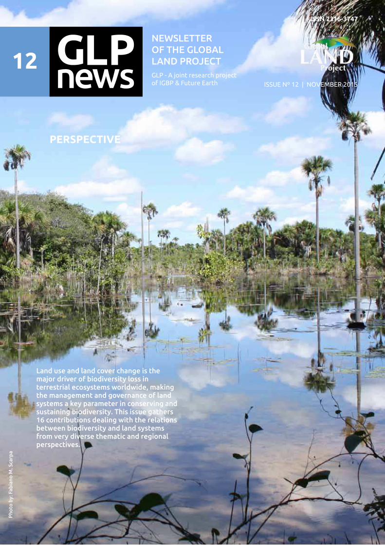
Land use and land cover change is the major driver of biodiversity loss in terrestrial ecosystems worldwide, making the management and governance of land systems a key parameter in conserving and sustaining biodiversity. This issue gathers 16 contributions dealing with the relations between biodiversity and land systems from very diverse thematic and regional perspectives.
Ph
oto
by
: F
ab
ian
o M
. S
carp
a
GL
PN
EWS
| N
OV
EMB
ER 2
01
5
2
International Project O┆ce - GLP IPO
National Institute for Space Research - INPE
Earth System Science Centre - CCST
Av. dos Astronautas, 1758 CCST Building, 1st Floor, Room 22Jd. Granja - 12227-010 São José dos CamposSão Paulo - Brazil
O┆ce phone: +55 12 3208 7938
www.globallandproject.org
Dr. Jean Pierre Henry
Balbaud OmettoINPE Liason Researcher
O┆ce phone: +55 12 3208 7903
Dr. Sébastien BoillatExecutive O┆cer
O┆ce phone: +55 12 3208 7931
Dr. Fabiano Micheletto ScarpaProject O┆cer
O┆ce phone: +55 12 3208 7942
Scienti┃c Steering Committee – SSCPeter Verburg (Chair of GLP, 2011-2016)Institute for Environmental Studies - VU University AmsterdamDe Boelelaan 1087 - 1081 HV Amsterdam - NetherlandsEmail: [email protected]
Roy Rinku ChowdburrySchool of Geography Clark University Worcester, MA 01610-1477Email: [email protected]
Patrick MeyfroidtSST/ELI - Earth and Life Institute (ELI) - ELIC - Earth & Climate (ELIC) - Université Catholique de Louvain (UCL)ELIC - Place Louis Pasteur 3 bte - L4.03.08 à 1348 Louvain-la-Neuve - BelgiumEmail: [email protected]
Allison M. ThomsonJoint Global Change Research Institute 5825 University Research Court, Suite 3500 College Park, MD 20740Email: [email protected]
Souleymane KonatéResearch Pole on Environment and Sustainable Development.University of Nangui Abrogoua (Ex- Abobo-Adjamé), UFR-SN.02 BP 801 Abidjan 02, Côte d�IvoireEmail: [email protected] | [email protected]
Karlheinz ErbInstitute for Social Ecology - University of KlagenfurtSchottenfeldgasse 29/5t - A-1070 Vienna - AustriaEmail: [email protected]
Nancy GolubiewskiLand Use Carbon Analysis System (LUCAS) - Ministry for the Environment � Manatu Mo Te Taiao23 Kate Sheppard Place, PO Box 10362, Wellington 6143 - New ZelandEmail: [email protected]
Jonathan Morgan Grove Northern Research Station - USDA Forest Service5200 Westland Blvd. TRC 171 - MD 21227, Baltimore - United States of AmericaEmail: [email protected]
Andreas HeinimannCentre for Development and Environment - University of BerneHallerstrasse 10, 3012 Bern, SwitzerlandEmail: [email protected]
Harini NagendraAzim Premi University - PES Institute of Technology CampusElectronics City, Hosur Road, Bangalore - IndiaEmail: [email protected]
Erle C. EllisDept. of Geography & Environmental Systems - University of Maryland1000 Hilltop Circle, Baltimore, MD 21250 - United States of AmericaEmail: [email protected]
Lin ZhenInstitute of Geographic Science and Natural Resources Research, Chinese - Academy of SciencesDeputy Director of Research Unit for Resource Ecology and Biomass Resources11A Datun Road, Chaoyang District, Beijing 100101- PR ChinaEmail: [email protected], [email protected]
Neville D. Crossman Senior Research Scientist, Team Leader, CSIRO Ecosystem SciencesCSIRO Ecosystem Sciences, Private Bag 2, Glen Osmond, SA, 5064 - AustraliaEmail: [email protected]
Ole MertzDepartment of Geography and Geology, University of Copenhagen, Oster Voldgade 10, 1350 Copenhagen K. - DenmarkEmail: [email protected]
Patrick H. HostertHead of Geomatics Lab, Deputy Director of Geography DepartmentHumboldt-Universität zu Berlin, Geography Department / Geomatics LabUnter den Linden 6, 10099 Berlin - GermanyEmail: [email protected]
Héctor Ricardo GrauInstituto de Ecología Regional - Universidad Nacional de Tucumán-CONICETCasilla de Correo 34, (4107) Yerba Buena, Tucumán - ArgentinaEmail: [email protected]
12
Coverpage
Vereda ecosystem in the Brazilian Cerrado - a biodiversity hotspotPhoto by Fabiano M. Scarpa
GLP News is a newsletter of the Global Land Project
Editors:Sébastien Boillat
Fabiano Micheletto Scarpa
Peter Verburg
Jean Pierre Henry Balbaud Ometto

GL
PN
EWS
| N
OV
EMB
ER 2
01
5
3
Nearly 30 years ago, the term biodiversity became widely used after a publication by Edward O. Wilson in 1988 and was formally de┃ned by the Convention on Biological Diversity enacted 1992 in Rio de Janeiro, Brazil. Despite many e━orts performed since then by international organizations, governments, civil society and the private sector to conserve biodiversity and manage it sustainably, the remaining challenges are huge. The process of massive and acute modi┃cation of the Earth system started at the Industrial Revolution in the 18th Century is still under way. Human activities have particularly intensi┃ed since the last 50 years, as population and consumption standards continue to grow. These activities include urbanization and conversion of natural ecosystems into agricultural areas, pasture and industrial crops to supply human needs for food, fuel and ┃ber, leading to habitat destruction for many species (Haines-Young, 2009; Mantyka-Pringle, 2015). It is estimated that biodiversity loss is currently happening at a rate that ranges between 1000 and 10,000 times higher than the natural extinction rate (Benn, 2010; De Vos et al. 2014, Mantyka-Pringle, 2015) and is already beyond the safe limits (Rockstrom 2009). Consequences are serious as biodiversity is strongly linked to bene┃ts associated to ecosystems and human wellbeing (ecosystem services) including preservation of water resources, provision of pollinators for crops, pest control, discovery of new medicines, timber, soil conservation, recycling of nutrients, and climate regulation (Cardinale et.al. 2012).
To address these urgent issues, biodiversity conservation and management has gradually switched from a disciplinary approach centered on the conservation of single species, to more systemic and interdisciplinary approaches that address biodiversity as part of complex social-ecological systems. In this framework, land use and land cover-change (LULCC) has been identi┃ed as the major driver of biodiversity loss in terrestrial ecosystems worldwide (Nagendra et al. 2013), making the management and governance of land systems a key parameter in conserving and sustaining biodiversity. More holistic and integrative approaches to the conservation and management of biodiversity are re┅ected in recent international normative frameworks, such as the Sustainable Development Goals launched this year by the United Nations, which set up ambitious goals in terms of the achievement of sustainable development at global scale. The goal number 15 which aims to “Protect, restore and promote sustainable use of terrestrial ecosystems, sustainably manage forests, combat deserti┃cation,
EDITORIAL
and halt and reverse land degradation and halt biodiversity loss� (ICSU, ISSC, 2015) is of particular interest to address the relationships between biodiversity and land systems. Another entry point to protect biodiversity is the soil conservation and management agenda, with 2015 declared the International Year of Soils, and the observation that about 25% of the world´s arable land is degraded a━ecting food security and ecosystem functioning (Ahukaemere et.al. 2012). In this issue, we present original contributions of the GLP community dealing with the relations between biodiversity and land systems from very diverse thematic and regional perspectives. Biodiversity hotspots are natural environments that are crucial for conservation purposes as they host high levels of endemism and have been reduced to at least 60% of their original area. Thirty-┃ve biodiversity hotspots have been identi┃ed to date, representing 2,3 % of the land surface (Marchese, 2015). In this magazine four studies were conducted in such areas, the Atlantic rainforest, the Afromontane and Coastal forests of Eastern Africa, Madagascar, and Western Australia. R. Viani and colleagues show their ┃ndings related to the restoration of a remnant of the Atlantic rainforest in southeastern Brazil. C. Capitani and colleagues stress on the e━ects of land use and climate change in the forests of Kenya and Tanzania. J. C. Llopis, C. J. Gardner and X. Vincke focus on the problems regarding land-cover change in the spiny forests of Madagascar. Finally, H. Lambers discusses the threats a megadiverse region - Southwest Australia - is facing.
Several additional studies address the drivers of land cover change and their implications for biodiversity. P. Fearnside writes about the expansion of soybean production in the Amazon rainforest and its relationship with deforestation. The interaction between humans and ecosystems in the Amboseli region, Kenya is discussed by C. J. C. Mustaphi, A. C. Shoemaker and R. Marchant. A. Ovando, G. Tejada and J. Tomasella show the e━ects of land cover change on hydrology of the Bolivian Amazon lowlands. The e━ects of agriculture abandonment and ┃re on forest succession in Kaluzhskie Zaseki State Nature Reserve, Russia is shown by M. Bobrovsky and L. Khanina. Land change a━ecting ecosystems and water resources was assessed by J. Helmschrot and colleagues.
Other studies focus on speci┃c demands for natural resources, including biodiversity, which
Biodiversity and Land Systems
GL
PN
EWS
| N
OV
EMB
ER 2
01
5
4
are increasing across the planet. The paper by H. Dao and D. Friot shows the ecological footprint of Switzerland in relation with global planetary boundaries. S. Mishra discusses land cover change and its relationship with market trends and biodiversity. In the highlands of Argentina, Bolivia and Chile, A. Izquierdo and colleagues discuss the major threat increasing mining activities poses for these biodiverse and fragile regions. Other papers highlight monitoring and governance solutions to address these challenges. These include the use of remote sensing as a technique for monitoring ecosystems and ┅oods in Southern Africa, presented by M. Mück and colleagues. A. Augustyn and colleagues show why territorial approaches are important for conservation in rural Europe. Mapping of mangroves across the world is presented by A. Ximenes as an important tool for conservation purposes. Finally X. Hua and J. Yan also warn us about overprotection of species, such as wild boars in China, which is surprisingly threatening wildlife and livelihoods.
This newsletter marks a major organizational transition, since the hosting of GLP International Project O┆ce by the National Institute for Space Research (INPE) in São José dos Campos, Brazil, will conclude this December. During its INPE period lasting from 2012 to 2015, GLP endorsed and coordinated 18 research projects, published several synthesis works, was involved in organizing the 2nd Open Science Meeting in Berlin in March 2014, made the transition from IGBP/IHDP to Future Earth - and created new nodal o┆ces. During this time, GLP has also strengthened its network in the Latin American region and will conclude this cycle with a workshop on land system science in Latin America which will take place this November. Therefore, GLP is thankful to INPE and the Brazilian Ministry of Science and Technology - and innovation for having successfully hosted the IPO during these four years.
Next year will open up new developments
Dr. Fabiano Micheletto Scarpa
Project O┆cer of the IGBP/Future Earth Global Land Project (GLP)
Dr. Sébastien Boillat
Executive O┆cer of the IGBP/ Future Earth Global Land Project (GLP)
Ahukaemere, C.M. et.al. (2012). Soil Quality and Soil Degradation as In┅uenced by Agricultural Land Use Types in the Humid Environment. International Journal of Forest, Soil and Erosion. 2 (4): 175-179.
Benn, J (2010). What is biodiversity? United Nations Environment Programme (UNEP).
Cardinale, B.J. et al. (2012) Biodiversity loss and its impact on humanity. Nature 459: 59-67.
De Vos, JM; Joppa, LN; Gittleman, JL; Stephens PR; Pimm SL. (2014). Estimating the normal background rate of species extinction. Conservation Biology. 29(2):452-62.
ICSU, ISSC (2015): Review of the Sustainable Development Goals: The Science Perspective. Paris: International Council for Science (ICSU).
Haines-Young, R. (2009). Land use and biodiversity relationships. and Use Policy (26) 178–186
References
and perspectives for GLP. From January 2016 onwards, the GLP International Project O┆ce will be based at the Centre for Development of Environment (CDE) at the University of Bern, Switzerland. The CDE has a strong focus on interdisciplinary research for sustainable development in collaboration with partners in the global North and South, and a large experience in fostering dialogue between science and society. These assets make the CDE the ideal institute to host GLP for the next four years and we wish them plenty of success in bringing the project forward for its next phase.
Furthermore, a key milestone for GLP next year will be the 3rd GLP Open Science Meeting hosted by the Chinese Academy of Agricultural Sciences, which will take place in Beijing, China, from 24 to 27 October 2016.
We wish you enjoy reading this magazine and wish you all the best for the End of the Year 2015 and the New Year 2016.
Sincerely,
Mantyka-Pringle, C.S.; Visconti, P.; Di Marco, M.; Martin, T.G.; Rondinini, C.; Rhodes, J.R. (2015). Climate change modi┃es risk of global biodiversity loss due to land-cover change Biological Conservation 187: 103�111.
Marchese, C. (2015). Biodiversity hotspots: A shortcut for a more complicated concept. Global Ecology and Conservation 3: 297�309.
Nagendra,H., Reyers, B., Lavorel, S. Impacts of land change on biodiversity: making the link to ecosystem services. Current Opinion in Environmental Sustainability. 5:503�508
Rockström, J.et.al.(2009). A safe operating space for humanity Nature 461, 472-475
Wilson EO (ed) (1988) Biodiversity. National Academy Press, Washington D.C., USA

GL
PN
EWS
| N
OV
EMB
ER 2
01
5
5
Land-use and land-cover change in a global biodiversity conservation priority. The case of the spiny forest of Madagascar
J. C. Llopis | C. J. Gardner | X. Vincke
Threats to the Southwest Australian Biodiversity Hotspot
H. Lambers
Natural riches of Amazonia, deforestation and its consequences
P. M. Fearnside
Historical ecology perspectives of change at Amboseli, Kenya
C. J. C. Mustaphi | A. C. Shoemaker E. N. Githumbi | R. Kariuki | R. M. Muriuki S. Rucina | R. Marchant
Environmental change and Water Ecosystem Services in the Bolivian Amazon Lowlands (Llanos de Moxos)
A. Ovando | G. Tejada | J. Tomasella
From Brazil to Switzerland: the GLP International Project O┆ce is moving
The Global Land Project publishes synthesis and outlook paper
Ecology in an anthropogenic biosphere
Land System Science in Latin America: achievements and perspectives
International Seminar
S. Boillat | F. M. Scarpa
PECS 2015 Conference
3rd GLP Open Science Metting - Land system science: understanding realities and developing solutions
CONTENTSPerspective
Feature - Article
06
10
14
19
22
26
30
News
Noticeboard
Announcements37
41
46
50
53
57
62
65
70
75
76
77
79
80
A new focus for ecological restoration: management of degraded forest remnants in fragmented landscapes
R. A. G. Viani | F. N. A. Mello | I. E. ChiP. H. S. Brancalion
Exploring the future land use-biodiversity-climate nexus in East Africa: an application of participatory scenario analysis
C. Capitania | O. Norfolk | P. Platts N. Burgess | K. Mukama | B. Mbilinyi I. Malugu | P. Munishi | R. Marchant
Spatio-temporal patterns of forest recovery on abandoned arable land:
fires and plant diversity
M. Bobrovsky I L. Khanina
Land cover change and its implication for the sustainable management of West African water resources
J. Helmschrot | H. M. Badjana E. P. Kabore/Bontogho
How sustainable is the land footprint of nations? A Planetary Boundary perspective applied to Switzerland
H. Dao | D. Friot
Researching into Bio-Energy Change and Sustainable Land Use in the New Millennium
S. K. Mishra
Side e━ects of green technologies: the potential environmental costs of Lithium mining on high elevation Andean wetlands in the context of climate change
Andrea Izquierdo | H.R. Grau J. Carilla | E. Casagranda
Remote sensing applications for assessing water-related risks and its interdependencies with land cover change and biodiversity in southern Africa
M. Mück | J. Helmschrot | H. ZimbaM. Wallner | M. Hipondoka I.A. Nyambe | P. Mufeti | M. Meinhard
Territorial approaches to enhance biodiversity in rural Europe
A. Augustyn | J. Brennan | S. FeretZ. Linhart | B. Soldaat
Global mangrove mapping: a critical tool for conservation
A. de C. Ximenes
The Risk of Protection: The Dilemma between Wildlife Protection and Cropland Use under Ecological Restoration
X. Hua | J. Yan
AGU Fall Meeting 2015
GLP Session: Emerging perspectives on land in a changing world
GLP and Pages session: Dating the Anthropocene: Early Land Use and Earth System Change
GL
PN
EWS
| N
OV
EMB
ER 2
01
5
6
A new focus for ecological restoration: management of degraded forest remnants in fragmented landscapes
Abstract
Ecosystem restoration is a global priority. Large-scale restoration programs have been recently launched with ambitious goals for forest restoration in fragmented tropical regions. Although cleared sites are being reforested in these regions, degraded forest remnants are often neglected regarding their restoration. We discuss why degraded forest remnants should be incorporated in the agenda of tropical forest restoration programs in currently fragmented regions, and the main challenges to make that an e━ective restoration strategy. Despite lower biodiversity and biomass, degraded forests are important for biodiversity conservation and human wellbeing in fragmented landscapes. Besides, the long-term sustainability of restoration sites embedded in fragmented landscapes depends on these forest fragments as biodiversity sources. Advances are necessary to consolidate the practice of restoring degraded forests. Lianas cutting, enrichment plantings and other restorations techniques need to be validated and policies to incentive restoration of those degraded forest need to be discussed with stakeholders involved in restoration.
1 Departamento de Biotecnologia e Produção Vegetal e Animal, Universidade Federal de São Carlos, Araras, SP, Brazil. 2 Departamento de Ciências Florestais, ESALQ - Universidade de São Paulo, Piracicaba, SP, BrazilCorresponding author: [email protected]
Ricardo Augusto Gorne Viani1 | Felipe Nery Arantes Mello2 | Isaí Euán Chi1
Pedro Henrique Santin Brancalion2
While reducing emissions from deforestation and forest degradation (REDD) initiatives are more common in less fragmented landscapes, in older human-modi┃ed tropical landscapes, forest restoration programs are focused on recovering forests where they were cleared and substituted by other land uses. Meanwhile, restoration of several small and degraded forest remnants in those landscapes have been neglected (Brancalion et al. 2012). Thus, our objective is to discuss 1) why degraded forest remnants should be incorporated in the agenda of tropical forest restoration programs, and 2) the main challenges to make restoration of degraded forest remnants an e━ective strategy to reinforce biodiversity conservation and ecosystem services provisioning in fragmented regions of the tropics.
Why should we be concerned about restoring forest remnants in fragmented landscapes?
Forest fragmentation (forest areas are cut down in previously continuous forest habitats leaving small patches) have converted many tropical regions in landscapes with small and isolated forest fragments (Haddad et al. 2015). Following fragmentation, many tropical forests have faced degradation by selective logging, ┃re, grazing and/or other disturbances (Hosonuma et al. 2012). Both forest fragmentation and degradation a━ect species composition and ecosystem services provisioning in the remaining forest patches (Aguirre and Dirzo 2008; Pütz et al. 2011; Ferraz et al. 2014; Pütz et al. 2014). Remarkably, degraded tropical forest fragments experience an increase in abundance and biomass of some speci┃c plant groups, such as bamboos (Lima et al. 2012) or, more commonly, climbers (Schnitzer and Bongers 2011). Climbers strongly compete with trees by water, nutrients and light, thus a━ecting trees physiological performance, growth, fecundity and survival (Schnitzer et al. 2005). As a result, degraded forest remnants have a strong reduction in tree species richness (Schnitzer and Carson 2010) and carbon stocks (Duran and Gianoli 2013). Consequently, degraded forests have constrains for provision of ecosystem
Per
spec
tive
Introduction
Ecological restoration is the process of assisting the recovery of an ecosystem that has been degraded, damaged, or destroyed (SER International Science & Policy Working Group 2004). Ecosystem restoration is now a global priority to reverse biodiversity loss, provide ecosystem services and strive to long-term sustainability of our human-dominated planet (Bullock et al. 2011; Aronson and Alexander 2013). Many large-scale restoration programs have been launched in the last years with ambitious goals (Pinto et al. 2014, Suding 2015). Until 2020, the Bonn Challenge aims to restore 150 million hectares around the globe while one of the Aichi Biodiversity Targets objectives is to recover at least 15% of degraded ecosystems globally.
GL
PN
EWS
| N
OV
EMB
ER 2
01
5
7
services and landscape biodiversity conservation. Besides, depending on perturbation frequency, intensity and duration, these forest fragments may remain in a steady state of degradation, unless restoration actions are implemented.
Despite all the negative e━ects of fragmentation and degradation, remaining forest patches are important landscape biodiversity refugees (Arroyo-Rodríguez et al. 2009; Tabarelli 2010; Joly et al. 2014) and, if properly managed, good sources of propagules for surrounding areas (Viani and Rodrigues 2009). Even though they were historically degraded and exposed to edge e━ects, their biodiversity levels and resilience are much greater than that of areas where forest were completely cleared � currently, the focus of many forest restoration programs in fragmented landscapes. In such restoration sites, recovery of forest is frequently based on high-density native tree seedlings plantations (Rodrigues et al. 2011), which is expensive and sometimes uncertain in its success in recovering biodiversity (Maron et al. 2012). Thus, restoring degraded forest fragments could be in some cases more cost-e━ective for biodiversity conservation and ecosystem services provisioning at the landscape level than
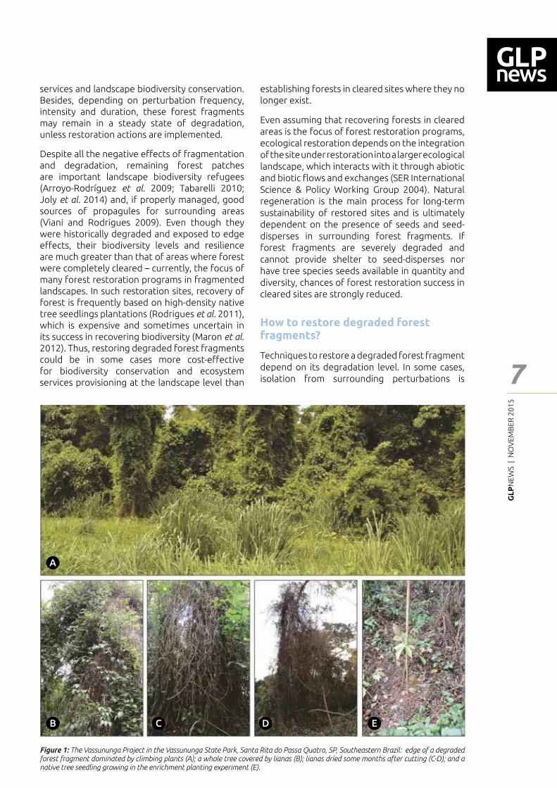
Figure 1: The Vassununga Project in the Vassununga State Park, Santa Rita do Passa Quatro, SP, Southeastern Brazil: edge of a degraded forest fragment dominated by climbing plants (A); a whole tree covered by lianas (B); lianas dried some months after cutting (C-D); and a native tree seedling growing in the enrichment planting experiment (E).
establishing forests in cleared sites where they no longer exist.
Even assuming that recovering forests in cleared areas is the focus of forest restoration programs, ecological restoration depends on the integration of the site under restoration into a larger ecological landscape, which interacts with it through abiotic and biotic ┅ows and exchanges (SER International Science & Policy Working Group 2004). Natural regeneration is the main process for long-term sustainability of restored sites and is ultimately dependent on the presence of seeds and seed-disperses in surrounding forest fragments. If forest fragments are severely degraded and cannot provide shelter to seed-disperses nor have tree species seeds available in quantity and diversity, chances of forest restoration success in cleared sites are strongly reduced.
How to restore degraded forest fragments?
Techniques to restore a degraded forest fragment depend on its degradation level. In some cases, isolation from surrounding perturbations is
A
B C D E
Per
spec
tive
GL
PN
EWS
| N
OV
EMB
ER 2
01
5
8
enough to forest self-recovering (Brancalion et al. 2012). However, in severely degraded landscapes, active restoration techniques are often needed.
The main technique to restore degraded fragments is the management of life forms that become hyperabundant, such as climbers (Rozza et al. 2007; Sfair et al. 2015). When climbers reach high densities and biomass, they cover whole trees and the forest canopy, reducing light availability for tree regeneration (Schnitzer et al. 2005). Operational ┃eld procedures consist in cutting the base of climbers, disconnecting them from the soil. Some months later, climbers dry up and fall down (Fig. 1). This process helps the reestablishment of tree canopy cover. Although it seems simple, climbers frequently resprout and grow fast again after cutting, which suggest that periodical cutting may be needed. In addition, despite being hyperabundant in degraded remnants, climbers are usually native species and an important life form for tropical ecosystems (Gentry and Dodson 1987). Thus, there is a debate on managing all or only the most abundant climbing plants (Sfair et al. 2015).
Even when periodically performed, climbers cutting may be not enough if the potential of natural regeneration in the forest fragment is severely impacted. In that occasions, restoration techniques to stimulate natural regeneration and forest succession, such as assisted natural regeneration, enrichment plantings and soil revolving to expose the soil tree seed bank to light, have been proposed to reestablish canopy cover (Rozza et al. 2007). In the assisted natural regeneration, control of invasive grasses and fertilization are performed around tree seedlings. In enrichment plantings, native tree seedlings are planted in the forest understory or in the gaps created by climbers cutting. Despite several studies have already been performed, results from experimental tests are not conclusive and not always successful, thus several challenges regarding their e━ectiveness, costs and operational feasibility remain.
The Vassununga project: a case study in the Atlantic Forest
To address the lack of large-scale projects aiming to validate the practice of restoring degraded tropical forest fragments, we established, in 2013, the Vassununga Project. It is a 10.6 ha long-term project established with the objective of investigating costs, operational feasibility and overall e━ectiveness of liana cutting, assisted natural regeneration and enrichment plantings as restoration techniques for degraded forest fragments. Vassununga project is located at Vassununga State Park (VSP, 21°42-43�S and 47°34�-38�W), a protected area in Southeastern Brazil that experienced a strong ┃re event in the 1970�s and is in a steady state of degradation, with high abundance of climbers (Fig. 1). The
study sites are within the Atlantic Forest biome. Atlantic Forest is a global biodiversity hotspot (Myers et al. 2000) with less than 16% of its original cover remaining in scattered distributed small and degraded forest remnants (Ribeiro et al. 2009). The project has the involvement of several stakeholders: 1) a private company that is compensating the impacts caused by a licensed construction; 2) environmental bodies that authorized this compensation with restoration techniques in VSP degraded forest remnants; 3) the public institution which takes care of the VSP; 4) a company implementing the restoration actions and; 5) researchers from Federal University of São Carlos and University of São Paulo, who are testing restoration techniques.
We established 54 plots of 45x44 m. Data collection has just been started and robust results will be generated in the following years. Early inventories estimated 13.7 climbers for each tree above 1 m height, a high relation compared to well-conserved forest (Gentry and Dodson 1987) that indicates that the study sites are severely degraded. In addition, we found that most of the climbers have small stem diameters (〝 1.5cm), which is di━erent from the ticker lianas typically found in less degraded forest landscapes (Laurance et al. 2001, Rice et al. 2004).
Next steps and ┃nal remarks
In fragmented landscapes, restoring forests in cleared areas is crucial to increase forest cover and provide some water-related ecosystem services when restoration sites are located in riparian bu━ers, for example. However, we clearly stated reasons for including restoration of degraded forest in the agenda of restoration programs in those landscapes: they are important for biodiversity conservation and ecosystem services provisioning at the landscape level. Besides, the long-term sustainability of other restoration areas strongly depend on these forest fragments as biodiversity sources. Nevertheless, advances are necessary to consolidate the practice of degraded forest restoration. Firstly, it is necessary to validate the main techniques to restore degraded forest remnants, with better investigation of their costs, operational procedures and overall e┆ciency. For that, large-scale restoration projects should be implemented in many tropical regions. Once these techniques are validated, the next step is to convince environmental bodies that in some conditions investing in managing degraded forest remnants may be more cost-e━ective than traditional recommendations of native tree plantings in cleared areas. Finally, it is necessary to discuss these strategies with other restoration stakeholders, aiming to develop policies to foster degraded forest restoration in fragmented landscapes. It is a long way to go, but ecological restoration is now a global priority and it is an opportune time to include new approaches in its science and practice.
Per
spec
tive
GL
PN
EWS
| N
OV
EMB
ER 2
01
5
9
References
Aguirre, A; Dirzo, R (2008). E━ects of Fragmentation on Pollinator Abundance and Fruit Set of an Abundant Understory Palm in a Mexican Tropical Forest. Biological Conservation 141(2): 375�84.
Aronson, J; Alexander, S (2013). Ecosystem restoration is now a global priority: Time to roll up our sleeves. Restoration Ecology 21:293-296.
Arroyo-Rodríguez, V; Pineda, E; Escobar, F; Benítez-Malvido, J (2009). Value of Small Patches in the Conservation of Plant-Species Diversity in Highly Fragmented Rainforest. Conservation Biology 23(3): 729�39.
Brancalion, PHS; Viani, RAG; Rodrigues, RR; Cesar, RG (2012). Estratégias para auxiliar na conservação de ┅orestas tropicais secundárias inseridas em paisagens alteradas. Boletim do Museu Paraense Emílio Goeldi. Ciências Naturais 7(1): 219�34.
Bullock, JM; Aronson, J.; Newton, AC; Pywell, RF; Rey-Benayas, JM (2011). Restoration of ecosystem services and biodiversity: con┅icts and opportunities. Trends in Ecology and Evolution 26(10):541-549.
Durán, S; Gianoli, E (2013). Carbon stocks in tropical forests decrease with liana density. 9: 20130301.
Ferraz, SFB; Ferraz, KMPMB; Cassiano, CC; Brancalion, PHS; da Luz, DTA; Azevedo, TN; Tambosi, LR; Metzger, JP (2014). How good are tropical forest patches for ecosystem services provisioning? Landscape Ecology 29(2):187�200.
Gentry, AG; Dodson, C. (1987). Contribution of nontrees to species richness of a tropical rain forest. Biotropica 19:149-156.
Haddad, NM et al. (2015). Habitat fragmentation and its lasting impact on Earth�s ecosystems. Science Advances 1:1-9.
Hosonuma, N; Herold, M; De Sy, V; De Fries, RS; Brockhaus, M; Verchot, L; Angelsen, A; Romijn, E (2012). An assessment of deforestation and forest degradation drivers in developing countries. Environmental Research Letters 7:1-12.
Joly, CA; Metzger, JP; Tabarelli, M (2014). Experiences from the Brazilian Atlantic Forest: Ecological Findings and Conservation Initiatives. New Phytologist 204(3): 459�73.
Laurance, WF; Pérez-Salicrup, D; Delamônica, P; Fearnside, P; D�Angelo, S; Jerozolinski, A; Pohl, L; Lovejoy, TE (2001). Rain forest fragmentation and the structure of Amazonian liana communities. Ecology 82(1):105-116.
Lima, RAF; Rother, DC; Muler, AE; Lepsch, IF; Rodrigues, RR (2012). Bamboo overabundance alters forest structure and dynamics in the Atlantic Forest hotspot. Biological Conservation 147(1): 32�39.
Maron, M; Hobbs, RJ; Moilanen, A; Matthews, JW; Christie, K; Gardner, TA; Keith, DA; Lindenmayer, DB; McAlpine, CA (2012). Faustian bargains? Restoration realities in the context of biodiversity o━set policies. Biological Conservation 155:141-148
Myers N, Mittermeier R, Mittermeier C, da Fonseca G, Kent J. 2000. Biodiversity hotspots for conservation priorities. Nature, 403: 853-858.
Pinto S; Melo F; Tabarelli M; Padovesi A; Mesquita A; Scaramuzza CA; Castro P; Carrascosa H; Calmon M; Rodrigues RR; César RG; Brancalion PHS (2014). Governing and delivering a biome-wide restoration initiative: The case of Atlantic Forest Restoration Pact in Brazil. Forests 5:2212-2229.
Pütz, S; Groeneveld, J; Alves, LF; Metznger, JP; Huth, A (2011). Fragmentation drives tropical forest fragments to early successional states: a modelling study for Brazilian Atlantic Forests. Ecological Modelling 222(12): 1986�97.
Pütz, S; Groeneveld, J; Henle, K; Knogge, C; Martensen, AC; Metz, M; Metzger, JP; Ribeiro, MC; de Paula, MD; Huth, A (2014). Long-Term Carbon Loss in Fragmented Neotropical Forests. Nature Communications 5.
Ribeiro, M; Metzger, JP; Martensen, A; Ponzoni F; Hirota M. (2009). The Brazilian Atlantic Forest: How much is left, and how is the remaining forest distributed? Implications for conservation. Biological Conservation 142:1141-1153.
Rice, K; Brokaw, N; Thompson, J. (2004) Liana abundance in a Puerto Rican Forest. Forest Ecology and Management 190:33-41.
Rodrigues, RR; Gandol┃, S; Nave, AG; Aronson, J; Barreto, TE; Vidal, CY; Brancalion, PHS (2011). Large-scale ecological restoration of high-diversity tropical forests in SE Brazil. Forest Ecology and Management 261(10): 1605�13.
Rozza, AF; Farah, FT; Rodrigues, RR (2007). Ecological management of degraded forest fragments. In: High diversity forest restoration in degraded areas: methods and projects in Brazil, eds. Rodrigues, RR; Martins, SV; Gandol┃, S. Nova Science Publishers, 171�96.
Schnitzer, SA; Kuzee, M; Bongers, F (2005). Disentangling above- and below-ground competition between lianas and trees in a tropical forest. Journal of Ecology 93(6):1115�1125.
Schnitzer, SA; WP, Carson (2010). Lianas suppress tree regeneration and diversity in treefall gaps. Ecology Letters, 13: 849�857.
Schnitzer, S.A. and F. Bongers (2011). Increasing liana abundance and biomass in tropical forests: emerging patterns and putative mechanisms. Ecology Letters, 14: 397-406.
Sfair, JC; Rochelle, ALC; van Melis, J; Rezende, AA; Weiser, VL; Martins, FR (2015). Theoretical approaches to liana management: a search for a less harmful method. International Journal of Biodiversity Science, Ecosystem Services & Management 11(2):1�7.
SER (Society for Ecological Restoration) International Science & Policy Working Group (2004). The SER International Primer on Ecological Restoration. www.ser.org & Tucson: Society for Ecological Restoration International.
Suding, K; Higgs, E; Palmer, M; Callicott, JB; Anderson, CB; Baker, M; Gutrich, JJ; Hondula, KL; LaFevor, MC; Larson, BM (2015). Committing to ecological restoration. Science 348:638-640.
Tabarelli, M (2010). Tropical Biodiversity in Human-Modi┃ed Landscapes: What Is Our Trump Card? Biotropica 42(5):553–54.
Viani, RAG; Rodrigues, RR (2009). Potential of the Seedling Community of a Forest Fragment for Tropical Forest Restoration. Scientia Agricola 66:772�79.
Per
spec
tive
GL
PN
EWS
| N
OV
EMB
ER 2
01
5
10
Exploring the future land use-biodiversity-climate nexus in East Africa: an application of participatory scenario analysis.
1 York Institute for Tropical Ecosystems, University of York, Environment Department, York, UK2 University of York, Department of Biology, York, UK3 UNEP_WCMC, Cambridge, UK4 WWF Tanzania, Forest programme, Dar es Saalam, Tanzania5 Sokoine University of Agriculture, Morogoro, TanzaniaCorresponding author: [email protected]
Claudia Capitani1 | Olivia Norfolk1 | Philip Platts2 | Neil Burgess3 | Kusaga Mukama4 | Boniface Mbilinyi5 | Isaac Malugu4 | Pantaleo Munishi5 | Rob Marchant1
Abstract
Climate change and land-use-land-cover change (LULCC) are expected to have major impacts on global biodiversity. In highly diverse tropical moist forests, future biodiversity trajectories will also depend on political and societal will to undertake the changes needed to reduce those impacts. We present a framework to build participatory spatially-explicit scenarios that can be used to analyse the biodiversity-climate-land-change trade-o━s, and we applied at di━erent scales in East Africa. In Tanzania, under the business-as-usual pattern of economic growth, the Eastern Arc Mountains forests and biodiversity will be heavily impacted on, with increasing pressure on protected areas. Increasing variability of rainfall and temperature are likely to impact on where the LCLCC are going to be, with the mountains likely to be refuges that are even more important for local communities. That may intensify impacts on biodiversity. In Taita Hills (Kenya) and Jimma Highlands (Ethiopia), stakeholders expected that adaptation interventions to climate change would generally improve biodiversity state. Preliminary data on birds community diversity in Taita Hills showed that though agroforestry system supports higher diversity than natural forest, species richness of rarer forest specialists remained highest within natural forests.
Anticipating future conservation and agriculture interaction under climate change may contribute to set spatial priorities for intervention sites. Further investigations are required that could bene┃t from integrating local stakeholders� perceptions and visions for the future.
Introduction
Land use and land cover changes (LULCC) have impacted natural systems over the last centuries: in conjunction with climate change, major impacts on global biodiversity are expected. The e━ects may be further altered by complex climate-land-cover feedbacks, which remain poorly understood (Mantyka-Pringle et al 2015). Assessing the impacts of LULCC dynamics and climate change, and their synergistic interaction, is especially needed for tropical moist forests, since they host most of the global biodiversity (Lambin et al. 2011, Brodie et al. 2012, Laurence et al. 2014).
Many tropical countries have low-to-middle income economies and overexploitation of natural resources is occurring either to meet basic needs for the rapidly growing and developing populations, or to supply commodities for foreign markets. The development of policies supporting win-win outcomes with economic incentives to sustainable forest management and biodiversity conservation have raised expectation that tropical forests can support biodiversity conservation and enhance livelihoods of those communities that rely on forest resources. These incentives include mechanisms for payment for ecosystem services (PES) as well as for climate change mitigation (e.g.: Clean Development Mechanism and Reduced Emissions from Deforestation and Degradation (REDD+) expected to support large-scale carbon emission reductions and to promote multiple bene┃ts, including biodiversity protection and economic payment. However, since pilot phases have started, signi┃cant trade-o━s have emerged between carbon emission reduction and biodiversity (and livelihood) safeguards. Setting appropriate spatial priorities is one of the critical elements to maximize e┆ciency and opportunities for REDD+ (Carwardine et al. 2015) and, more
Feat
ure
- Art
icle
GL
PN
EWS
| N
OV
EMB
ER 2
01
5
11
Feat
ure
- Art
icle
broadly, for policies on land use and climate change in relation to biodiversity.
Biodiversity future trajectories in tropical regions will also depend on societal willingness and capacity, at di━erent levels, to undertake the changes needed to reduce the impacts of climate change and LULCC, either directly (conservation) or indirectly (land management, climate change mitigation, conservation agriculture, etc). Yet, establishing alternative sustainable pathways ┃rst requires assessing and resolving competition amongst di━erent societal needs and resource demands.
Hence, the importance of developing approaches to analyse the biodiversity-climate-land-change nexus that: 1) investigate societal perceptions and possible reactions to environmental changes across scales, 2) directly involve local actors in developing future visions, to enhance a sense of ownership that builds capacity to actively engage in implementation, and 3) produces appropriate quantitative and spatially-explicit outputs that can inform decision-making processes.
We developed a framework for integrating stakeholders� participation through qualitative, quantitative and spatial analyses to develop scenarios of future LULCC, under di━erent policies or environmental (climate) conditions. We present how scenario outputs can be used to anticipate policies trade-o━s (e.g.: between land uses and biodiversity), as well as to assess possible future interactions between LULCC, climate change and biodiversity.
Methods
The scenarios building framework follows a mixed approach whereby a modellers� team including experts in di━erent disciplines set up general frames and then local stakeholders ┃ll them with qualitative and semi-quantitative information. The modellers then translate this information into quantitative and spatially-explicit outputs. The ┃nal outputs are created following subsequent stakeholders� validation of preliminary results.
Stakeholders are selected among local and regional governments, civil society organisations, research institutions, and private sectors (farmers, pastoralist, and business people). During workshops, participants are engaged in focus group discussions on trade-o━s between socio-economic conditions (i.e. income, production) and environmental condition (i.e. land use and cover changes, resources depletion) in the regional context. Starting from the situation at present, they develop sectorial narratives and trajectories for alternative future projections, and translate
the identi┃ed trajectories and driving forces into speci┃c LULCC (Fig. 1a). For each LULCC type, they provide standardised information on �how much�, �why� and �where� they would occur under the future scenarios (Fig. 1a). This information is then used by the modellers to identify spatial indicators of LULCC and to create speci┃c composite indicators of LULCC risk for each vegetation type. Demand for main commodities (e.g.: food crops and wood for energy) is estimated according to population growth by the scenario time horizon and converted into land surfaces. Scenario maps are ┃nally created using the spatial indicators of risk to allocate spatial changes that are required to ful┃ll the estimated demand.
Case studies
We applied this framework at sub-national and national level in Tanzania mainland within the framework of a REDD+ pilot projecta, and at local level in the Taita Hills (Kenya) and the Jimma Highlands (Ethiopia), in a project focusing on impacts of climate change on food security and ecosystem services in mountain ecosystems in East Africa (CHIESAb). The study areas include the biodiversity hotspots of Eastern Afromontane and Coastal forests of Eastern Africa.
We proposed two simple, but signi┃cantly di━erent, alternative scenarios and we let stakeholders develop locally oriented narratives for possible future trajectories of LULCC and/or climate changes. In the ┃rst case study, we explored pathways towards sustainable development, with a focus on halting deforestation and degradation through REDD+ implementations, as opposed to a business-as-usual scenario (BAU). In the second case study, we presented stakeholders climate projection for mean temperature and rainfall patterns for the local sitesc, and we explored two alternative scenarios: either adaptation strategies to climate changes were put in place or not (BAU).
Results
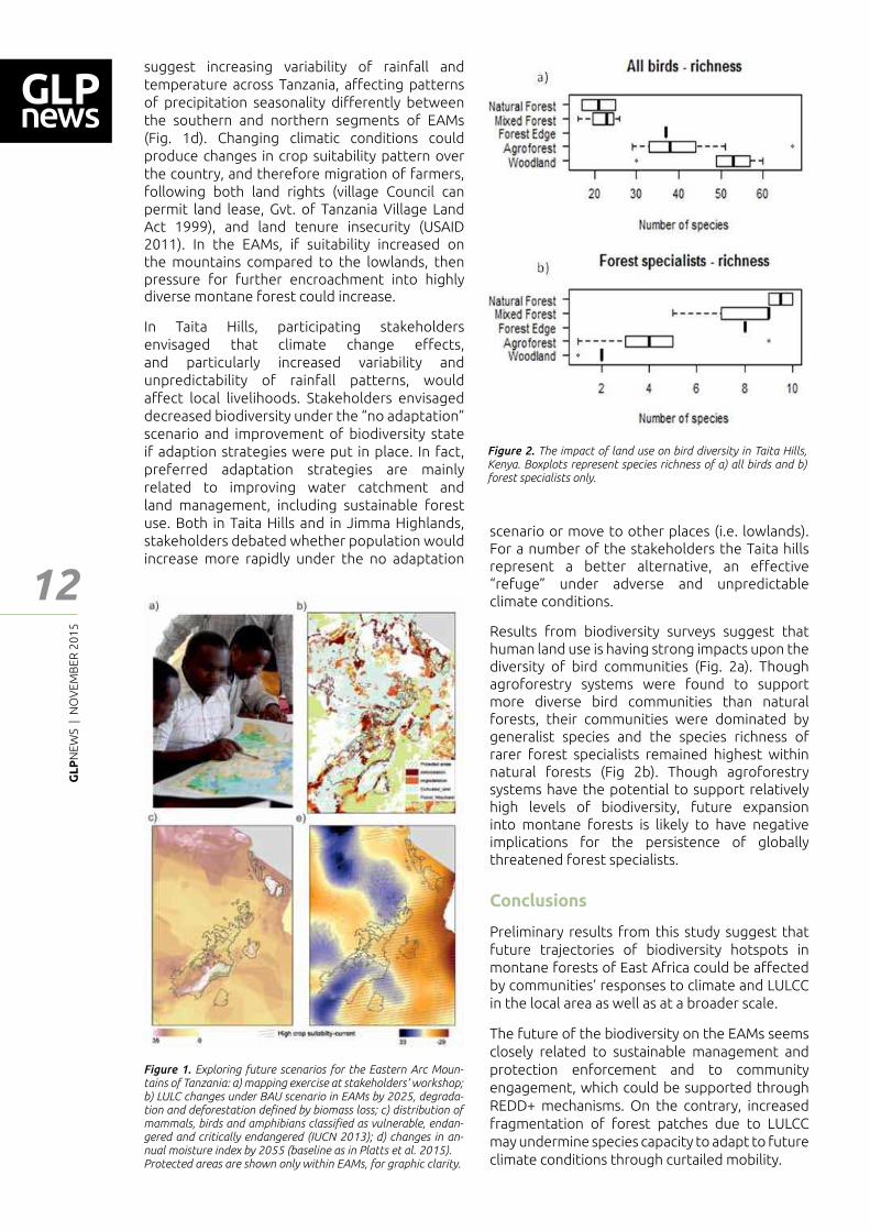
In Tanzania, under BAU, the economy is expected to grow at the expense of the environment, since dependency on biomass and farmland expansion continue in the absence of land use planning and technological improvement. In the Eastern Arc Mountains (EAMs), this would result in an 8% loss of montane forest and 26% of woodland due to farmland expansion. Additionally, 30% of woodland would be degraded as consequence of timber harvesting and charcoal production (Fig. 1b and c). According to our scenario, protected areas are essential for limiting the strong pressure for LULCC in EAM forests. Climate projections
a http://d2ouvy59p0dg6k.cloudfront.net/downloads/wwf___redd__┃nal_project_report___10th_april_2015_1.pdfb http://chiesa.icipe.org/c Projection obtained using AFRICLIM v3.0, RCP4.5 and RCP8.5 representative concentration pathways for mid-century (mean over 2041-20700, Platts et al. 2015).
GL
PN
EWS
| N
OV
EMB
ER 2
01
5
12
suggest increasing variability of rainfall and temperature across Tanzania, a━ecting patterns of precipitation seasonality di━erently between the southern and northern segments of EAMs (Fig. 1d). Changing climatic conditions could produce changes in crop suitability pattern over the country, and therefore migration of farmers, following both land rights (village Council can permit land lease, Gvt. of Tanzania Village Land Act 1999), and land tenure insecurity (USAID 2011). In the EAMs, if suitability increased on the mountains compared to the lowlands, then pressure for further encroachment into highly diverse montane forest could increase.
In Taita Hills, participating stakeholders envisaged that climate change e━ects, and particularly increased variability and unpredictability of rainfall patterns, would a━ect local livelihoods. Stakeholders envisaged decreased biodiversity under the �no adaptation� scenario and improvement of biodiversity state if adaption strategies were put in place. In fact, preferred adaptation strategies are mainly related to improving water catchment and land management, including sustainable forest use. Both in Taita Hills and in Jimma Highlands, stakeholders debated whether population would increase more rapidly under the no adaptation
Figure 1. Exploring future scenarios for the Eastern Arc Moun-tains of Tanzania: a) mapping exercise at stakeholders� workshop; b) LULC changes under BAU scenario in EAMs by 2025, degrada-tion and deforestation de┃ned by biomass loss; c) distribution of mammals, birds and amphibians classi┃ed as vulnerable, endan-gered and critically endangered (IUCN 2013); d) changes in an-nual moisture index by 2055 (baseline as in Platts et al. 2015). Protected areas are shown only within EAMs, for graphic clarity.
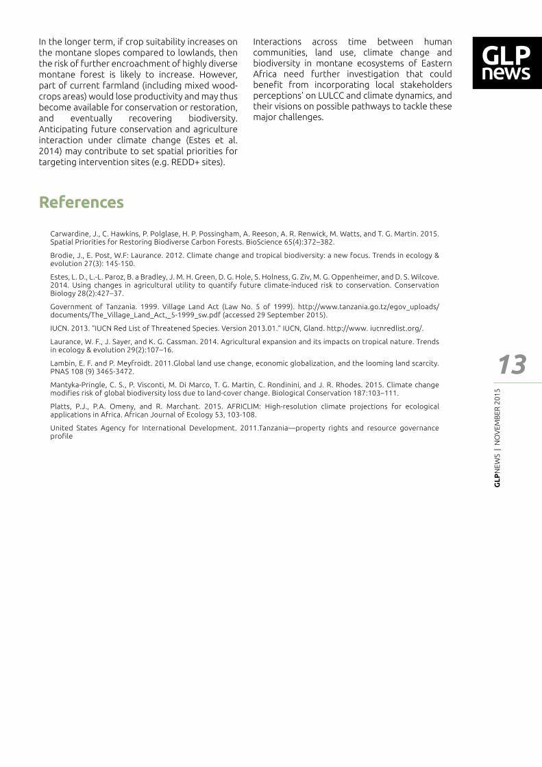
Figure 2. The impact of land use on bird diversity in Taita Hills, Kenya. Boxplots represent species richness of a) all birds and b) forest specialists only.
scenario or move to other places (i.e. lowlands). For a number of the stakeholders the Taita hills represent a better alternative, an e━ective �refuge� under adverse and unpredictable climate conditions.
Results from biodiversity surveys suggest that human land use is having strong impacts upon the diversity of bird communities (Fig. 2a). Though agroforestry systems were found to support more diverse bird communities than natural forests, their communities were dominated by generalist species and the species richness of rarer forest specialists remained highest within natural forests (Fig 2b). Though agroforestry systems have the potential to support relatively high levels of biodiversity, future expansion into montane forests is likely to have negative implications for the persistence of globally threatened forest specialists.
Conclusions
Preliminary results from this study suggest that future trajectories of biodiversity hotspots in montane forests of East Africa could be a━ected by communities� responses to climate and LULCC in the local area as well as at a broader scale.
The future of the biodiversity on the EAMs seems closely related to sustainable management and protection enforcement and to community engagement, which could be supported through REDD+ mechanisms. On the contrary, increased fragmentation of forest patches due to LULCC may undermine species capacity to adapt to future climate conditions through curtailed mobility.
Feat
ure
- Art
icle
GL
PN
EWS
| N
OV
EMB
ER 2
01
5
13
Feat
ure
- Art
icle
In the longer term, if crop suitability increases on the montane slopes compared to lowlands, then the risk of further encroachment of highly diverse montane forest is likely to increase. However, part of current farmland (including mixed wood-crops areas) would lose productivity and may thus become available for conservation or restoration, and eventually recovering biodiversity. Anticipating future conservation and agriculture interaction under climate change (Estes et al. 2014) may contribute to set spatial priorities for targeting intervention sites (e.g. REDD+ sites).
Carwardine, J., C. Hawkins, P. Polglase, H. P. Possingham, A. Reeson, A. R. Renwick, M. Watts, and T. G. Martin. 2015. Spatial Priorities for Restoring Biodiverse Carbon Forests. BioScience 65(4):372�382.
Brodie, J., E. Post, W.F: Laurance. 2012. Climate change and tropical biodiversity: a new focus. Trends in ecology & evolution 27(3): 145-150.
Estes, L. D., L.-L. Paroz, B. a Bradley, J. M. H. Green, D. G. Hole, S. Holness, G. Ziv, M. G. Oppenheimer, and D. S. Wilcove. 2014. Using changes in agricultural utility to quantify future climate-induced risk to conservation. Conservation Biology 28(2):427�37.
Government of Tanzania. 1999. Village Land Act (Law No. 5 of 1999). http://www.tanzania.go.tz/egov_uploads/documents/The_Village_Land_Act,_5-1999_sw.pdf (accessed 29 September 2015).
IUCN. 2013. �IUCN Red List of Threatened Species. Version 2013.01.� IUCN, Gland. http://www. iucnredlist.org/.
Laurance, W. F., J. Sayer, and K. G. Cassman. 2014. Agricultural expansion and its impacts on tropical nature. Trends in ecology & evolution 29(2):107�16.
Lambin, E. F. and P. Meyfroidt. 2011.Global land use change, economic globalization, and the looming land scarcity. PNAS 108 (9) 3465-3472.
Mantyka-Pringle, C. S., P. Visconti, M. Di Marco, T. G. Martin, C. Rondinini, and J. R. Rhodes. 2015. Climate change modifies risk of global biodiversity loss due to land-cover change. Biological Conservation 187:103�111.
Platts, P.J., P.A. Omeny, and R. Marchant. 2015. AFRICLIM: High-resolution climate projections for ecological applications in Africa. African Journal of Ecology 53, 103-108.
United States Agency for International Development. 2011.Tanzania�property rights and resource governance profile
Interactions across time between human communities, land use, climate change and biodiversity in montane ecosystems of Eastern Africa need further investigation that could bene┃t from incorporating local stakeholders perceptions� on LULCC and climate dynamics, and their visions on possible pathways to tackle these major challenges.
References
GL
PN
EWS
| N
OV
EMB
ER 2
01
5
14
Land-use and land-cover change in a global biodiversity conservation priority. The case of the spiny forest of Madagascar
Jorge C. Llopis1 | Charlie J. Gardner2 | Xavier Vincke3
Abstract
Although expansion of agricultural and pasture land for industrial production are replacing shifting cultivation as major proximate causes of forest loss in many forest-frontier areas of the world, the latter land use, for production of either subsistence or cash crops, continues to play a signi┃cant role in land-cover change dynamics in many tropical developing countries.
These land-use and land-cover change processes often take place upon forests that are habitat for a large portion of the world�s biodiversity, with potentially negative implications for this biological richness and the capacity of these ecosystems to provide much needed services to human populations. Within this global panorama, the case of the spiny forest of Madagascar is particularly relevant for both its biodiversity wealth and threatened status. Shifting cultivation here has increased greatly in the last two decades as a result of demographic, economic and climatic factors, which combine to force farmers into the forest.
multiple scales, from hydrological regulation and soil conservation at the local-regional level, to carbon storage and sequestration at the global scale.
At the crossroads between these biological and socio-economic features, shifting cultivation is practiced over large areas of the country, constituting the main cause of land-cover change in the island, but which underlying drivers are not always well understood.
Land-cover change in the spiny forest
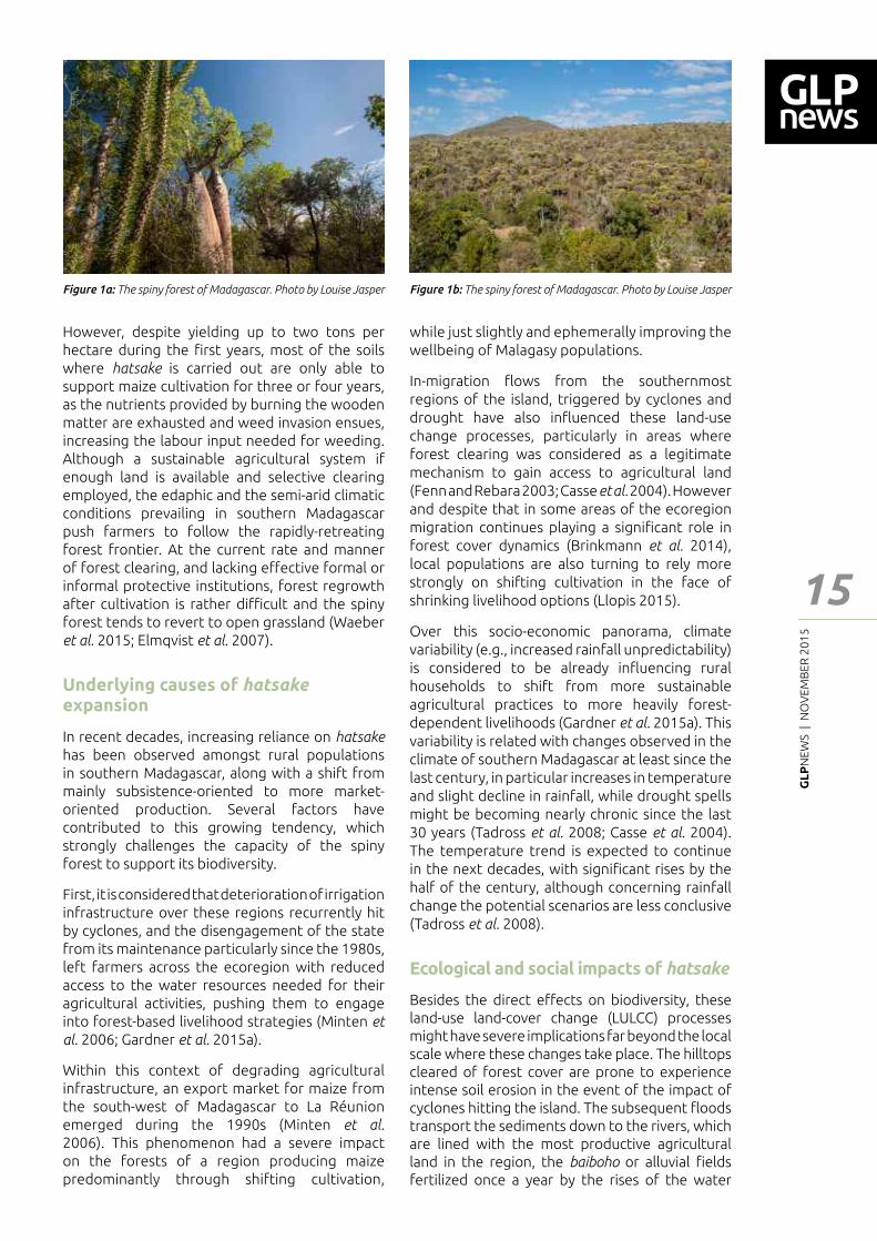
The case of the dry spiny forest-thicket ecoregion occurring in the south and southwestern regions of the island is a prime example to illustrate this problematic. These forests harbour some of the highest rates of endemism in Madagascar while constituting a central element of cultural and spiritual signi┃cance for rural populations, but have also su━ered some of the fastest deforestation rates in the country over the last two decades (Figure 1) (Waeber et al. 2015; Gardner et al. 2008; Harper et al. 2007).
Although charcoal production, cattle raising and extractive activities (e.g., mining) also in┅uence the spiny forest�s ecological dynamics, shifting cultivation remains the main cause of land-cover change (Casse et al. 2004; Waeber et al. 2015).
Regionally known as hatsake, shifting cultivation for rain-fed maize production has been traditionally employed by rural households to complement their main livelihood strategies, as an inexpensive and labour-e┆cient way to obtain relatively good yields on the rather unproductive upland soils of southern Madagascar. Hatsake, which resorts to slash-and-burn for forest clearing, demands few inputs besides the labour and tools necessary for clearing, sowing, weeding and harvesting tasks, while the primarily rain-fed condition of the system reduces substantially the demand for watering.
1 Center of African Studies. University of Copenhagen, Denmark; 2 Durrell Institute of Conservation and Ecology (DICE), School of Anthropology and Conservation, University of Kent, UK 3 Blue Ventures Conservation, Level 2 Annex, Omnibus Business Centre, 39-41 North Road, London N7 9DP, UK3 WWF Madagascar and Western Indian Ocean Programme Oice, BP 738, Antananarivo 101, MadagascarCorresponding authors: [email protected]; [email protected]; [email protected]
Feat
ure
- Art
icle
Introduction
Madagascar is a haven for biological diversity, with endemism rates of 82% for ┅ora and 84% for fauna (Goodman and Benstead 2005; Callmander et al. 2011). This biodiversity occurs primarily in a variety of forest ecosystems, from evergreen moist rainforest and sub-humid forest, to dry deciduous and spiny dry forest (Goodman and Benstead 2005).
A large share of the two thirds of the Malagasy populations living in rural areas rely on forest resources to meet their subsistence and cash income needs, while forested areas also supply multiple goods to urban populations, including construction and energy wood. Furthermore, these forests provide ecosystem services at
GL
PN
EWS
| N
OV
EMB
ER 2
01
5
15
Feat
ure
- Art
icle
However, despite yielding up to two tons per hectare during the ┃rst years, most of the soils where hatsake is carried out are only able to support maize cultivation for three or four years, as the nutrients provided by burning the wooden matter are exhausted and weed invasion ensues, increasing the labour input needed for weeding. Although a sustainable agricultural system if enough land is available and selective clearing employed, the edaphic and the semi-arid climatic conditions prevailing in southern Madagascar push farmers to follow the rapidly-retreating forest frontier. At the current rate and manner of forest clearing, and lacking e━ective formal or informal protective institutions, forest regrowth after cultivation is rather di┆cult and the spiny forest tends to revert to open grassland (Waeber et al. 2015; Elmqvist et al. 2007).
Underlying causes of hatsake
expansion
In recent decades, increasing reliance on hatsake has been observed amongst rural populations in southern Madagascar, along with a shift from mainly subsistence-oriented to more market-oriented production. Several factors have contributed to this growing tendency, which strongly challenges the capacity of the spiny forest to support its biodiversity.
First, it is considered that deterioration of irrigation infrastructure over these regions recurrently hit by cyclones, and the disengagement of the state from its maintenance particularly since the 1980s, left farmers across the ecoregion with reduced access to the water resources needed for their agricultural activities, pushing them to engage into forest-based livelihood strategies (Minten et
al. 2006; Gardner et al. 2015a).
Within this context of degrading agricultural infrastructure, an export market for maize from the south-west of Madagascar to La Réunion emerged during the 1990s (Minten et al. 2006). This phenomenon had a severe impact on the forests of a region producing maize predominantly through shifting cultivation,
while just slightly and ephemerally improving the wellbeing of Malagasy populations.
In-migration ┅ows from the southernmost regions of the island, triggered by cyclones and drought have also in┅uenced these land-use change processes, particularly in areas where forest clearing was considered as a legitimate mechanism to gain access to agricultural land (Fenn and Rebara 2003; Casse et al. 2004). However and despite that in some areas of the ecoregion migration continues playing a signi┃cant role in forest cover dynamics (Brinkmann et al. 2014), local populations are also turning to rely more strongly on shifting cultivation in the face of shrinking livelihood options (Llopis 2015).
Over this socio-economic panorama, climate variability (e.g., increased rainfall unpredictability) is considered to be already in┅uencing rural households to shift from more sustainable agricultural practices to more heavily forest-dependent livelihoods (Gardner et al. 2015a). This variability is related with changes observed in the climate of southern Madagascar at least since the last century, in particular increases in temperature and slight decline in rainfall, while drought spells might be becoming nearly chronic since the last 30 years (Tadross et al. 2008; Casse et al. 2004). The temperature trend is expected to continue in the next decades, with signi┃cant rises by the half of the century, although concerning rainfall change the potential scenarios are less conclusive (Tadross et al. 2008).
Ecological and social impacts of hatsake
Besides the direct e━ects on biodiversity, these land-use land-cover change (LULCC) processes might have severe implications far beyond the local scale where these changes take place. The hilltops cleared of forest cover are prone to experience intense soil erosion in the event of the impact of cyclones hitting the island. The subsequent ┅oods transport the sediments down to the rivers, which are lined with the most productive agricultural land in the region, the baiboho or alluvial ┃elds fertilized once a year by the rises of the water
Figure 1a: The spiny forest of Madagascar. Photo by Louise Jasper Figure 1b: The spiny forest of Madagascar. Photo by Louise Jasper

GL
PN
EWS
| N
OV
EMB
ER 2
01
5
16cyclones on the rural populations and subsequent shifts on the livelihood strategies they pursue.
Challenges for New Protected Areas on the spiny forest – The case of Ranobe PK32
To halt these intense LULCC processes, several New Protected Areas (NPAs) were established in the last decade on the spiny forest ecoregion, although with varying outcomes. The case of Ranobe PK32 exempli┃es the complexity of the challenges faced by biodiversity conservation under adverse environmental and economic conditions.
Ranobe PK32 is located between the Mozambique Channel and the Fiherena and Manombo rivers, constituting the richest area for faunal biodiversity in the south-west region. Local communities have traditionally relied on the forest resources in the area to meet their energy and construction wood needs, while the area hosted one of the largest and less disturbed remaining tracts of spiny forest in southern Madagascar until the early 1990s. However, at that time increasing LULCC processes began severely a━ecting the forest cover, coinciding with the growth of the export market reviewed above and the impact of cyclones and drought. Concretely these processes are driven by hatsake in the spiny forest on limestone plateau in the east of the NPA (Figure 2), and charcoal production in the forest on red sands along the coast in the west.
With the aim of halting these LULCC processes, in 2008 a NPA covering some 160,000 ha was
level. Despite being relatively extraordinary events, cyclone-related ┅oods may lead to the siltation of the alluvial plots, severely reducing their productivity due to the layer of infertile sand left upon them, as occurred with the passage of cyclone Haruna in 2013.
This phenomenon is particularly acute in the south-west, precisely the region of Madagascar where more forest was lost between 1990 and 2010 (over 400,000 ha) and crossed by several rivers discharging into the Mozambique Channel (ONE et al. 2013). Moreover, in a parallel phenomenon to that a━ecting the baiboho ┃elds, a large amount of the sediments carried by these rivers end up silting the Toliara reef system stretching along the southwestern Malagasy coast. This process is likely to su━ocate the coral, having severe implications for the marine ecosystems� biodiversity and the coastal human populations relying primarily on these ┃sheries for their livelihoods (Maina et al. 2013). As a result of declining marine resources, some ┃shers in the region are already abandoning ┃shing for forest-based livelihoods, further increasing pressure on forest ecosystems (Gardner et al. 2015a).
Future expected changes in the occurrence of cyclones point to a slight decrease in the frequency of these events, but in parallel with an increasing intensity (Tadross et al. 2008). While the direct e━ect of these extreme phenomena on the forest cover dynamics are not negligible (Waeber et al. 2015), the most severe implications for the spiny forest might be brought about by the impact of
Figure 2: Upland shifting cultivation ┃elds in Ranobe PK32 NPA. Photo by Xavier Vincke
Feat
ure
- Art
icle
GL
PN
EWS
| N
OV
EMB
ER 2
01
5
17
Feat
ure
- Art
icle
References
Brinkmann, K., F. Noromiarilanto, R.Y. Ratovonamana, and A. Buerkert, 2014. Deforestation processes in south-western Madagascar over the past 40 years: what can we learn from settlement characteristics? Agriculture, Ecosystems and Environment, 195: p. 231-243.
Busch, J., R. Dave, L. Hannah, A. Cameron, A. Rasolohery, P. Roehrdanz and G. Schatz, 2012. Climate Change and the Cost of Conserving Species in Madagascar. Conservation Biology 26 (3): 408-419.
Callmander, M. W., P. B. Phillipson, G. E. Schatz, S. Andriambololonera, M. Rabarimanarivo, N. Rakotonirina, J. Raharimampionona, C. Chatelain, L. Gautier, P. P. L. Ii and M. V. Callmander, 2011. The endemic and non-endemic vascular ┅ora of Madagascar updated. Plant Ecology and Evolution 144 (2): 121-125.
Casse, T., A. Milhøj, S. Ranaivoson and J. R. Randriamanarivo, 2004. Causes of deforestation in southwestern Madagascar: what do we know? Forest Policy and Economics 6 (1): 33-48.
Elmqvist, T., M. Pyykönen, M. Tengö, F. Rakotondrasoa, E. Rabakonandrianina and C. Radimilahy, 2007. Patterns of Loss and Regeneration of Tropical Dry Forest in Madagascar: The Social Institutional Context. PLoS ONE 2 (5): e402.
Fenn, M. and F. Rebara, 2003. Present Migration Tendencies and Their Impacts in Madagascar�s Spiny Forest Ecoregion. Nomadic Peoples 7 (1): 123-137.
Gardner, C. J., B. Ferguson, F. Rebara and A. N. Ratsifandrihamanana, 2008. Integrating traditional values and management regimes into Madagascar�s expanded protected area system: the case of Ankodida. in: Protected Landscapes and Cultural and Spiritual Values. (ed.: J.-M. Mallarach). Kasparek Verlag, Heidelberg, IUCN, GTZ and Obra Social de Caixa Catalunya: 92-103.
Gardner, C. J., F. U. L. Gabriel, F. A. V. St. John and Z. G. Davies, 2015a. Changing livelihoods and protected area management: a case study of charcoal production in south-west Madagascar. Oryx FirstView: 1-11.
Gardner, C. J., X. Vincke, S. Rafanomezantsoa and M. Virah-Sawmy, 2015b. Oblique Aerial Photography: A Novel Tool for the Monitoring and Participatory Management of Protected Areas. Parks 21 (1): 13-28.
Goodman, S. M. and J. P. Benstead, 2005. Updated estimates of biotic diversity and endemism for Madagascar. Oryx 39 (01): 73-77.
established in Ranobe PK32 within the Durban Vision strategy, a comprehensive conservation initiative launched in 2003 that entailed the objective of protecting up to 10% of Madagascar�s surface (Virah-Sawmy et al. 2014). With the goal of enabling local populations to engage in a sustainable exploitation of the forest resources while protecting its biodiversity wealth, the management regime was proposed as a multiple-use protected area. To achieve these objectives, economic alternatives (e.g., promotion of ecotourism and agroforestry), and support for their permanent agricultural practices were intended to be provided to rural communities, although to date their e━ective implementation has not been completely realised. Since about 90,000 people live around the NPA and many others within its boundaries, the development of sustainable livelihoods programmes at the necessary scale is a major challenge for the promoters, the international NGO WWF (Virah-Sawmy et al. 2014). This challenge has been exacerbated by the political coup of 2009, following which many donors reduced their funding to Madagascar.
Although relative successes were attained through aerial surveillance of the NPA and sensitization of local communities, these LULCC processes have continued nearly unabated up to present time, and rural populations remain in a vulnerable situation subjected to the e━ect
of diverse environmental hazards (Gardner et al. 2015b; Llopis 2015). Findings of recent research in the NPA have revealed the signi┃cant role played by the urban demand from Toliara, the regional capital located nearby the NPA, on the land-use change dynamics in the area, with the rainfall variability and e━ect of cyclone-related ┅oods in┅uencing shifts on the livelihoods of local households (Gardner et al. 2015a; Llopis 2015).
Conclusion
The spiny forest ecoregion of Madagascar has served as an illustration of how biodiversity conservation objectives are challenged by LULCC processes driven by a complex range of underlying causes. Over the present panorama, global climate change is likely to put additional pressure upon the livelihoods of the rural population main agent of LULCC, particularly due to projected rises in temperature over the areas of occurrence of the spiny forest and the potentially enhanced e━ects of extreme climatic events (Tadross et al. 2008). The combination of all these factors will likely increase the hindrances and costs for biodiversity conservation (Hannah et al. 2008; Busch et al. 2012). Further research on how these dynamics operate is needed in order to inform appropriate conservation and development interventions, and in particular to devise e━ective adaptation measures to support rural populations in coping with the expected future changes
GL
PN
EWS
| N
OV
EMB
ER 2
01
5
18
Hannah, L., R. Dave, P. P. L. II, S. Andelman, M. Andrianarisata, L. Andriamaro, A. Cameron, R. Hijmans, C. Kremen, J. MacKinnon, H. H. Randrianasolo, S. Andriambololonera, A. Raza┃mpahanana, H. Randriamahazo, J. Randrianarisoa, P. Raza┃njatovo, C. Raxworthy, G. E. Schatz, M. Tadross and L. Wilmé, 2008. Climate change adaptation for conservation in Madagascar. Biology Letters 4: 590�594.
Harper, G. J., M. K. Steininger, C. J. Tucker, D. Juhn and F. Hawkins, 2007. Fifty years of deforestation and forest fragmentation in Madagascar. Environmental Conservation 34 (4): 325�333.
Llopis, J. C., 2015. Climate change, development and nature conservation. Perceived realities and prospects in south-west Madagascar. Paper presented at the: 6th European Conference on African Studies, Paris, 8-10 July 2015.
Maina, J., H. de Moel, J. Zinke, J. Madin, T. McClanahan and J. E. Vermaat, 2013. Human deforestation outweighs future climate change impacts of sedimentation on coral reefs. Nature Communications 4: 1-7.
Minten, B., P. Meral, L. Randrianarison and J. F. M. Swinnen, 2006. Trade Liberalization, Rural Poverty And The Environment: The Case Of Madagascar. Antananarivo, WWF Madagascar. 151 pp.
ONE, DGF, FTM, MNP and CI, 2013. Evolution de la Couverture de forêts naturelles à Madagascar 2005-2010. Antananarivo. 42 pp.
Tadross, M., L. Randriamarolaza, Z. Rabe┃tia and Z. K. Yip, 2008. Climate change in Madagascar; recent past and future, Climate Systems Analysis Group, University of Cape Town. South Africa and National Meteorological O┆ce, Antananarivo, Madagascar. 18 pp.
Virah-Sawmy, M., C. J. Gardner and A. N. Ratsifandrihamanana, 2014. The Durban Vision in practice. Experiences in the participatory governance of Madagascar�s new protected areas. in: Conservation and Environmental Management in Madagascar. (ed.: I. R. Scales). Abingdon and New York, Routledge: 216-251.
Waeber, P. O., L. Wilmé, B. Ramamonjisoa, C. Garcia, D. Rakotomalala, Z.H. Rabemananjara, C. A. Kull, J. U. Ganzhorn and J.-P. Sorg, 2015. Dry forests in Madagascar: neglected and under pressure. Dry forests in Madagascar: neglected and under pressure 17 (S2): 127-148.
Feat
ure
- Art
icle
GL
PN
EWS
| N
OV
EMB
ER 2
01
5
19
Feat
ure
- Art
icle
Threats to the Southwest Australian Biodiversity Hotspot
1 School of Plant Biology, University of Western AustraliaCorresponding author: [email protected]
Hans Lambers1
Southwest Australia is a megadiverse region, one of only 25 Global Biodiversity Hotspots for conservation priorities as de┃ned by Myers et al. (2000). Biodiversity Hotspots are de┃ned as regions �where exceptional concentrations of endemic species are undergoing exceptional loss of habitat�. As many as 44% of all species of vascular plants and 35% of all species in four vertebrate groups are con┃ned to 25 hotspots comprising only 1.4% of the land surface of the Earth. This opens the way for a conservation strategy, focusing on these hotspots in proportion to their share of the world�s species at risk (Myers et al., 2000).
There are three main threats for the Southwest Australian Biodiversity Hotspot: A) introduced mammals, B) land-use change and C) weeds and pathogens. As discussed, these threats are intimately linked and interact with each other.
Introduced mammals
These include small animals, such as feral cats and foxes. The main method to control them is
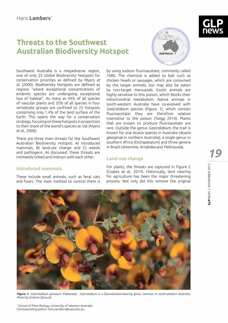
by using sodium ┅uoroacetate, commonly called 1080. The chemical is added to bait such as chicken heads or sausages, which are consumed by the target animals, but may also be eaten by non-target marsupials. Exotic animals are highly sensitive to this poison, which blocks their mitochondrial metabolism. Native animals in south-western Australia have co-evolved with Gastrolobium species (Figure 1), which contain ┅uoroacetate; they are therefore relative insensitive to the poison (Twigg 2014). Plants that are known to produce ┅uoroacetate are rare. Outside the genus Gastrolobium, the trait is known for one Acacia species in Australia (Acacia
georginae in northern Australia), a single genus in southern Africa (Dichapetalum) and three genera in Brazil (Amorimia, Arrabidea and Pallicourea).
Land-use change
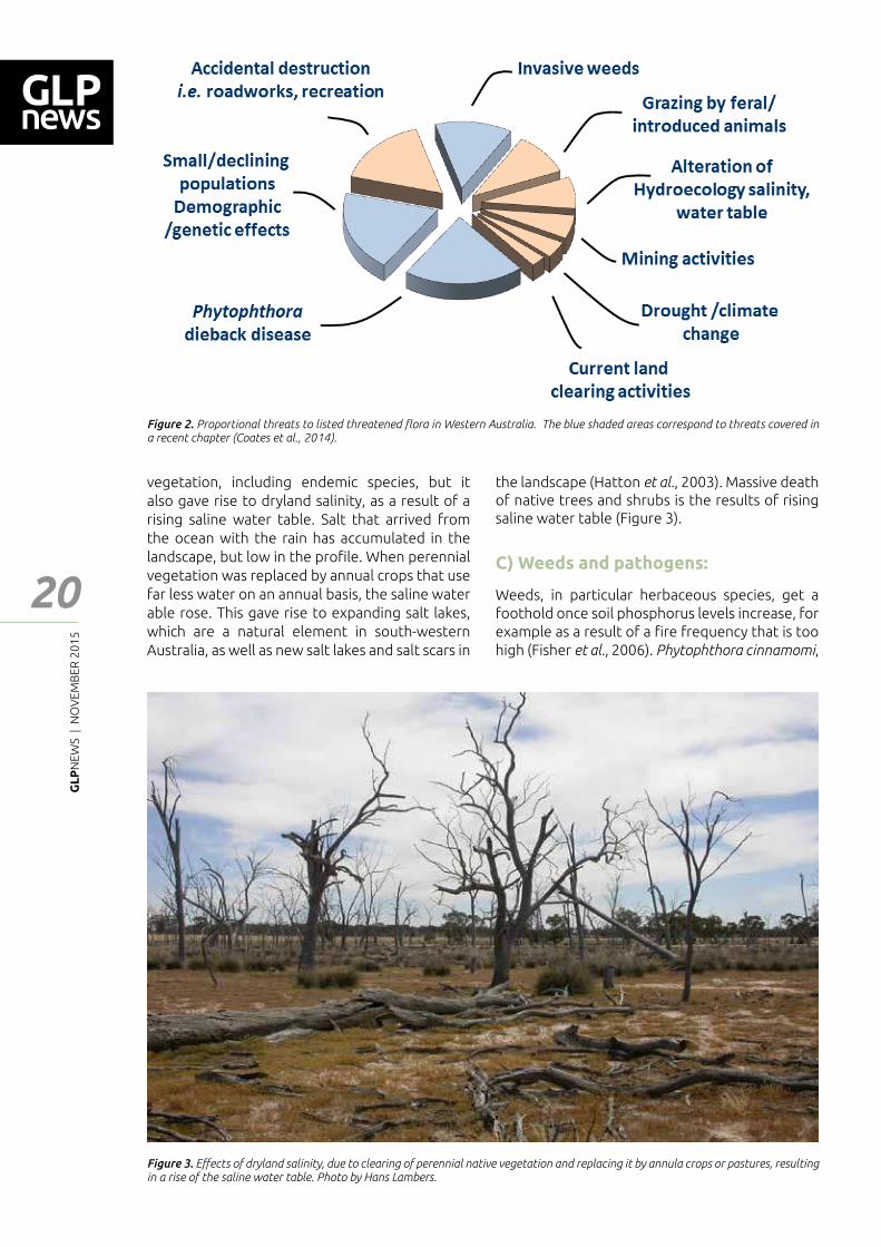
For plants, the threats are captured in Figure 2 (Coates et al., 2014). Historically, land clearing for agriculture has been the major threatening process. Not only did this remove the original
Figure 1. Gastrolobium spinosum (Fabaceae). Gastrolobium is a ┅uoroacetate-bearing genus common in south-western Australia. Photo by Graham Zemunik.
GL
PN
EWS
| N
OV
EMB
ER 2
01
5
20
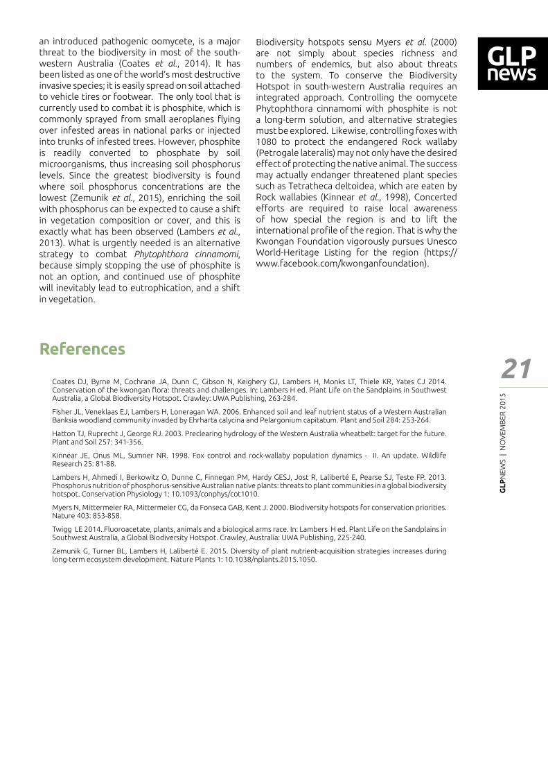
vegetation, including endemic species, but it also gave rise to dryland salinity, as a result of a rising saline water table. Salt that arrived from the ocean with the rain has accumulated in the landscape, but low in the pro┃le. When perennial vegetation was replaced by annual crops that use far less water on an annual basis, the saline water able rose. This gave rise to expanding salt lakes, which are a natural element in south-western Australia, as well as new salt lakes and salt scars in
Figure 2. Proportional threats to listed threatened ┅ora in Western Australia. The blue shaded areas correspond to threats covered in a recent chapter (Coates et al., 2014).
Figure 3. E━ects of dryland salinity, due to clearing of perennial native vegetation and replacing it by annula crops or pastures, resulting in a rise of the saline water table. Photo by Hans Lambers.
the landscape (Hatton et al., 2003). Massive death of native trees and shrubs is the results of rising saline water table (Figure 3).
C) Weeds and pathogens:
Weeds, in particular herbaceous species, get a foothold once soil phosphorus levels increase, for example as a result of a ┃re frequency that is too high (Fisher et al., 2006). Phytophthora cinnamomi,
Feat
ure
- Art
icle
GL
PN
EWS
| N
OV
EMB
ER 2
01
5
21
Feat
ure
- Art
icle
Coates DJ, Byrne M, Cochrane JA, Dunn C, Gibson N, Keighery GJ, Lambers H, Monks LT, Thiele KR, Yates CJ 2014. Conservation of the kwongan ┅ora: threats and challenges. In: Lambers H ed. Plant Life on the Sandplains in Southwest Australia, a Global Biodiversity Hotspot. Crawley: UWA Publishing, 263-284.
Fisher JL, Veneklaas EJ, Lambers H, Loneragan WA. 2006. Enhanced soil and leaf nutrient status of a Western Australian Banksia woodland community invaded by Ehrharta calycina and Pelargonium capitatum. Plant and Soil 284: 253-264.
Hatton TJ, Ruprecht J, George RJ. 2003. Preclearing hydrology of the Western Australia wheatbelt: target for the future. Plant and Soil 257: 341-356.
Kinnear JE, Onus ML, Sumner NR. 1998. Fox control and rock-wallaby population dynamics - II. An update. Wildlife Research 25: 81-88.
Lambers H, Ahmedi I, Berkowitz O, Dunne C, Finnegan PM, Hardy GESJ, Jost R, Laliberté E, Pearse SJ, Teste FP. 2013. Phosphorus nutrition of phosphorus-sensitive Australian native plants: threats to plant communities in a global biodiversity hotspot. Conservation Physiology 1: 10.1093/conphys/cot1010.
Myers N, Mittermeier RA, Mittermeier CG, da Fonseca GAB, Kent J. 2000. Biodiversity hotspots for conservation priorities. Nature 403: 853-858.
Twigg LE 2014. Fluoroacetate, plants, animals and a biological arms race. In: Lambers H ed. Plant Life on the Sandplains in Southwest Australia, a Global Biodiversity Hotspot. Crawley, Australia: UWA Publishing, 225-240.
Zemunik G, Turner BL, Lambers H, Laliberté E. 2015. Diversity of plant nutrient-acquisition strategies increases during long-term ecosystem development. Nature Plants 1: 10.1038/nplants.2015.1050.
an introduced pathogenic oomycete, is a major threat to the biodiversity in most of the south-western Australia (Coates et al., 2014). It has been listed as one of the world�s most destructive invasive species; it is easily spread on soil attached to vehicle tires or footwear. The only tool that is currently used to combat it is phosphite, which is commonly sprayed from small aeroplanes ┅ying over infested areas in national parks or injected into trunks of infested trees. However, phosphite is readily converted to phosphate by soil microorganisms, thus increasing soil phosphorus levels. Since the greatest biodiversity is found where soil phosphorus concentrations are the lowest (Zemunik et al., 2015), enriching the soil with phosphorus can be expected to cause a shift in vegetation composition or cover, and this is exactly what has been observed (Lambers et al., 2013). What is urgently needed is an alternative strategy to combat Phytophthora cinnamomi, because simply stopping the use of phosphite is not an option, and continued use of phosphite will inevitably lead to eutrophication, and a shift in vegetation.
Biodiversity hotspots sensu Myers et al. (2000) are not simply about species richness and numbers of endemics, but also about threats to the system. To conserve the Biodiversity Hotspot in south-western Australia requires an integrated approach. Controlling the oomycete Phytophthora cinnamomi with phosphite is not a long-term solution, and alternative strategies must be explored. Likewise, controlling foxes with 1080 to protect the endangered Rock wallaby (Petrogale lateralis) may not only have the desired e━ect of protecting the native animal. The success may actually endanger threatened plant species such as Tetratheca deltoidea, which are eaten by Rock wallabies (Kinnear et al., 1998), Concerted e━orts are required to raise local awareness of how special the region is and to lift the international pro┃le of the region. That is why the Kwongan Foundation vigorously pursues Unesco World-Heritage Listing for the region (https://www.facebook.com/kwonganfoundation).
References
GL
PN
EWS
| N
OV
EMB
ER 2
01
5
22
Natural riches of Amazonia, deforestation and its consequences
Philip M. Fearnside1
Abstract
Amazonia�s greatest riches are in the environmental services provided by its natural ecosystems. These avoid the global warming that would be provoked by releasing their carbon stocks, recycle water that is essential to rainfall in Amazonia and in other areas (including São Paulo), and maintain biodiversity. While some progress has been made towards maintaining forest by tapping the value of these services, the forces of destruction have grown much faster, since incentives to clear the forest have been higher than the ones to conserve it. Destructive uses provide assured and immediate pro┃ts, whereas conserving forest for environmental services depends on ┃nancial rewards that are uncertain and removed in time.
approach divides Amazonia into eight �areas of endemism� (da Silva et al., 2005). Another is to divide the region into many grid cells and assign an arbitrary statistical threshold for the spread of the distribution to other grid cells (Kress et al., 1998). Either way, the western portion of Amazonia generally has both the largest number of species and the greatest endemism in the region, and some of the highest levels in the world.
Climate
Each hectare of Amazonian forest has a high biomass, but some other tropical forests, such as those in Southeast Asia, have higher per-hectare biomass. However, the vast area of Amazonia makes the total biomass and carbon stock much higher in this region, giving it an unparalleled role in future climate regulation. Forest �biomass� refers to the dry weight of the vegetation (mainly trees). From the point of view of greenhouse-gas emissions, total biomass is the important measure, which includes not only live trees and not only what is above ground, but also dead biomass and roots. In 2013 the mean estimated biomass of Brazil�s 4.2 million km2 �Amazonia biome� was 338.8 tons, or 163.5 tons of carbon per hectare, and the total biomass stock, despite loss of 16.7% to deforestation since the early 1970s, was still 121.2 billion tons, or 58.6 billion tons of carbon in 2013 (Nogueira et al., 2015). Maintaining Amazonian forest avoids global warming and sustains the region�s water cycle, which plays a key role in supplying water vapor that produces rain in non-Amazonian parts of Brazil (including São Paulo) and in neighboring countries such as Paraguay and Argentina (Fearnside, 2004, Arraut et al., 2012).
Deforestation
Amazon forest is threatened by deforestation (clear cutting). The cumulative total cleared in Brazil�s portion of the Amazon forest is now 20%, about 90% of this clearing having occurred in just
1 National Institute for Research in Amazonia (INPA)National Institute for Research in Amazonia (INPA), Manaus, Amazonas, Brazil. Corresponding author: [email protected]; http://philip.inpa.gov.br
Feat
ure
- Art
icle
Biodiversity
About two-thirds of the Amazon forest is in Brazil, the rest being shared by Bolivia, Peru, Ecuador and Colombia, while �greater� Amazonia encompasses tropical forests in Venezuela and the Guyanas. The natural richness of Amazonia is very great, with both the largest remaining area of the world�s tropical forest and the largest amount of fresh water (the annual ┅ow of the Amazon River is ┃ve to six times larger than that of the world�s second largest river: the Congo). Amazonia�s biodiversity (in terms of number of tree species per hectare) reaches a peak where the topography begins to rise at the foot of the Andes Mountains. Amazonia has an estimated 40,000 plant species, 3000 ┃shes, 1294 birds, 427 mammals, 427 amphibians and 378 reptiles (da Silva et al., 2005). Average endemism (the proportion of species that only occur here) is high, but it can be higher in some other tropical forests, such as the remaining patches of Brazil�s Atlantic forest. Endemism refers to the degree to which species only occur in only one geographical area, thus the de┃nition of this geographical area determines what is considered endemic. One
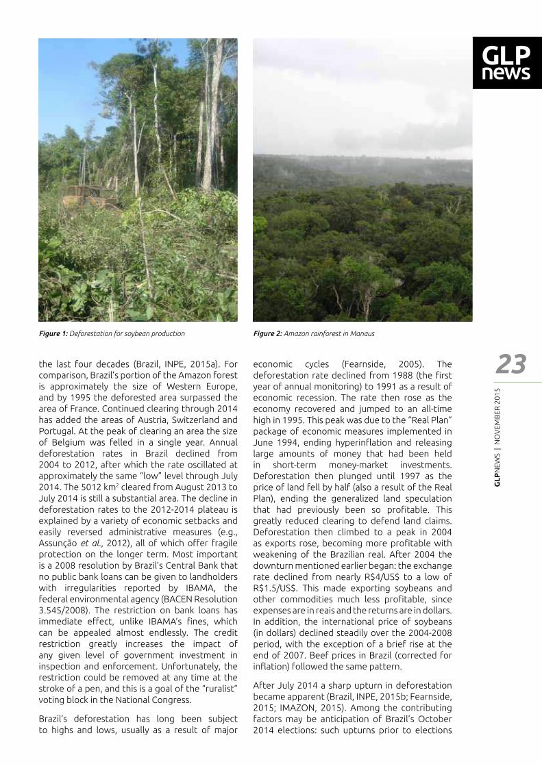
GL
PN
EWS
| N
OV
EMB
ER 2
01
5
23
Feat
ure
- Art
icle
the last four decades (Brazil, INPE, 2015a). For comparison, Brazil�s portion of the Amazon forest is approximately the size of Western Europe, and by 1995 the deforested area surpassed the area of France. Continued clearing through 2014 has added the areas of Austria, Switzerland and Portugal. At the peak of clearing an area the size of Belgium was felled in a single year. Annual deforestation rates in Brazil declined from 2004 to 2012, after which the rate oscillated at approximately the same �low� level through July 2014. The 5012 km2 cleared from August 2013 to July 2014 is still a substantial area. The decline in deforestation rates to the 2012-2014 plateau is explained by a variety of economic setbacks and easily reversed administrative measures (e.g., Assunção et al., 2012), all of which o━er fragile protection on the longer term. Most important is a 2008 resolution by Brazil�s Central Bank that no public bank loans can be given to landholders with irregularities reported by IBAMA, the federal environmental agency (BACEN Resolution 3.545/2008). The restriction on bank loans has immediate e━ect, unlike IBAMA’s ┃nes, which can be appealed almost endlessly. The credit restriction greatly increases the impact of any given level of government investment in inspection and enforcement. Unfortunately, the restriction could be removed at any time at the stroke of a pen, and this is a goal of the �ruralist� voting block in the National Congress.
Brazil�s deforestation has long been subject to highs and lows, usually as a result of major
economic cycles (Fearnside, 2005). The deforestation rate declined from 1988 (the ┃rst year of annual monitoring) to 1991 as a result of economic recession. The rate then rose as the economy recovered and jumped to an all-time high in 1995. This peak was due to the �Real Plan� package of economic measures implemented in June 1994, ending hyperin┅ation and releasing large amounts of money that had been held in short-term money-market investments. Deforestation then plunged until 1997 as the price of land fell by half (also a result of the Real Plan), ending the generalized land speculation that had previously been so pro┃table. This greatly reduced clearing to defend land claims. Deforestation then climbed to a peak in 2004 as exports rose, becoming more pro┃table with weakening of the Brazilian real. After 2004 the downturn mentioned earlier began: the exchange rate declined from nearly R$4/US$ to a low of R$1.5/US$. This made exporting soybeans and other commodities much less pro┃table, since expenses are in reais and the returns are in dollars. In addition, the international price of soybeans (in dollars) declined steadily over the 2004-2008 period, with the exception of a brief rise at the end of 2007. Beef prices in Brazil (corrected for in┅ation) followed the same pattern.
After July 2014 a sharp upturn in deforestation became apparent (Brazil, INPE, 2015b; Fearnside, 2015; IMAZON, 2015). Among the contributing factors may be anticipation of Brazil�s October 2014 elections: such upturns prior to elections
Figure 1: Deforestation for soybean production Figure 2: Amazon rainforest in Manaus
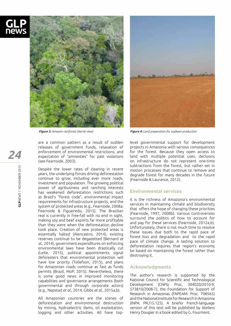
GL
PN
EWS
| N
OV
EMB
ER 2
01
5
24
are a common pattern as a result of sudden releases of government funds, relaxation of enforcement of environmental restrictions, and expectation of �amnesties� for past violations (see Fearnside, 2003).
Despite the lower rates of clearing in recent years, the underlying forces driving deforestation continue to grow, including ever more roads, investment and population. The growing political power of agribusiness and ranching interests has weakened deforestation restrictions such as Brazil�s �forest code�, environmental impact requirements for infrastructure projects, and the system of protected areas (e.g., Fearnside, 2008a; Fearnside & Figueiredo, 2015). The Brazilian real is currently in free-fall with no end in sight, making soy and beef exports far more pro┃table than they were when the deforestation decline took place. Creation of new protected areas is essentially halted (Alencastro, 2014), existing reserves continue to be degazetted (Bernard et al., 2014), government expenditures on enforcing environmental laws have been drastically cut (Leite, 2015), political appointments signal deforesters that environmental protection will have low priority (Tollefson, 2015), and plans for Amazonian roads continue as fast as funds permits (Brazil, MoP, 2015). Nevertheless, there is some good news in improved monitoring capabilities and governance arrangements (both governmental and through corporate actors) (e.g., Nepstad et al., 2014, Gibbs et al., 2015a,b).
All Amazonian countries are the scenes of deforestation and environmental destruction by mining, hydroelectric dams, oil exploitation, logging and other activities. All have top-
level governmental support for development projects in Amazonia with serious consequences for the forest. Because they open access to land with multiple potential uses, decisions on infrastructure do not represent one-time subtractions from the forest, but rather set in motion processes that continue to remove and degrade forest for many decades in the future (Fearnside & Laurance, 2012).
Environmental services
It is the richness of Amazonia�s environmental services in maintaining climate and biodiversity that o━ers the hope of changing these priorities (Fearnside, 1997, 2008b). Various controversies surround the politics of how to account for and pay for these services (Fearnside, 2012a,b). Unfortunately, there is not much time to resolve these issues due both to the rapid pace of forest loss and degradation and to the rapid pace of climate change. A lasting solution to deforestation requires that region�s economy be based on maintaining the forest rather than destroying it.
Acknowledgments
The author�s research is supported by the National Council for Scienti┃c and Technological Development (CNPq: Proc. 304020/2010-9; 573810/2008-7), the Foundation for Support of Research in Amazonas (FAPEAM: Proc. 708565) and the National Institute for Research in Amazonia (INPA: PRJ15.125). A briefer French-language version of this text will be published by Ateliers Henry Dougier in a book edited by G. Fourmont.
Figure 3: Amazon rainforest (Aerial view) Figure 4: Land preparation for soybean production
Feat
ure
- Art
icle

GL
PN
EWS
| N
OV
EMB
ER 2
01
5
25
Feat
ure
- Art
icle
References
Alencastro, C. (2014). Dilma não criou nenhuma nova unidade de conservação na Amazônia. O Globo. 4 August 2014 http://oglobo.globo.com/brasil/dilma-nao-criou-nenhuma-nova-unidade-de-conservacao-na-amazonia-13479261
Arraut, J.M., Nobre, C.A., Barbosa, H.M., Obregon; G., Marengo, J.A. (2012). Aerial rivers and lakes: Looking at large-scale moisture transport and its relation to Amazonia and to subtropical rainfall in South America. Journal of Climate 25: 543-556. doi: 10.1175/2011JCLI4189.1
Assunção, J., Gandour, C.C., Rocha, R. (2012). Deforestation Slowdown in the Legal Amazon: Prices or Policies? Climate Policy Initiative (CPI) Working Paper, Pontí┃ca Universidade Católica (PUC), Rio de Janeiro, RJ, Brazil. 37 pp., Available at: http://climatepolicyinitiative.org/publication/deforestation-slowdown-in-the-legal-amazon-prices-or-policie/
Bernard, E., Penna, L.A.O., Araújo, E. (2014). Downgrading, downsizing, degazettement, and reclassi┃cation of protected areas in Brazil. Conservation Biology 28: 939�950. doi: 10.1111/cobi.12298.
Brazil, INPE (Instituto Nacional de Pesquisas Espaciais). (2015a). Projeto PRODES: Monitoramento da Floresta Amazônica Brasileira por Satélite. INPE, São José dos Campos, São Paulo, Brazil. Available at: http://www.obt.inpe.br/prodes/
Brazil, INPE (Instituto Nacional de Pesquisas Espaciais). (2015b). Avaliação DETER 2015. INPE, São José dos Campos, São Paulo, Brazil. Available at: http://www.obt.inpe.br/deter/nuvens.php; http://www.obt.inpe.br/deter/avaliacao/2015/
Brazil, MoP (Ministério de Planejamento). (2015). Obras do PAC continuarão e programas de infraestrutura terão nova fase, garante Dilma. PAC Notícias, 10 March 2015. http://www.pac.gov.br/noticia/41db407a
da Silva, J.M.C., Rylands, A.B., da Fonseca, G.A.B. (2005). The fate of the Amazonian areas of endemism. Conservation Biology 19: 689�694. doi: 10.1111/j.1523-739.2005.00705.x
Fearnside, P.M. (1997). Environmental services as a strategy for sustainable development in rural Amazonia. Ecological Economics 20(1): 53-70. doi: 10.1016/S0921-8009(96)00066-3
Fearnside, P.M. (2003). Deforestation control in Mato Grosso: A new model for slowing the loss of Brazil�s Amazon forest. Ambio 32: 343-345.
Fearnside, P.M. (2004). A água de São Paulo e a ┅oresta amazônica. Ciência Hoje 34(203): 63-65.
Fearnside, P.M. (2005). Deforestation in Brazilian Amazonia: History, Rates and Consequences. Conservation Biology 19(3): 680-688. doi: 10.1111/j.1523-1739.2005.00697.x
Fearnside, P.M. (2008a). The roles and movements of actors in the deforestation of Brazilian Amazonia. Ecology and Society 13 (1): 23. http://www.ecologyandsociety.org/vol13/iss1/art23/
Fearnside, P.M. (2008b). Amazon forest maintenance as a source of environmental services. Anais da Academia Brasileira de Ciências 80(1): 101-114. doi: 10.1590/S0001-37652008000100006
Fearnside, P.M. (2012a). Brazil’s Amazon Forest in mitigating global warming: Unresolved controversies. Climate Policy 12(1): 70-81. doi: 10.1080/14693062.2011.581571
Fearnside, P.M. (2012b). The theoretical battle┃eld: Accounting for the climate bene┃ts of maintaining Brazil’s Amazon forest. Carbon Management 3(2): 145-148. doi: 10.4155/CMT.12.9
Fearnside, P.M. (2015). Deforestation soars in the Amazon. Nature 521: 423. doi: 10.1038/521423b
Fearnside, P.M., Figueiredo, A.M.R. (2015). China’s in┅uence on deforestation in Brazilian Amazonia: A growing force in the state of Mato Grosso. BU Global Economic Governance Initiative Discussion Papers 2015-3, Boston University, Boston, Massachusetts, USA. http://www.bu.edu/pardeeschool/┃les/2014/12/Brazil1.pdf
Fearnside, P.M., Laurance, W.F. (2012). Infraestrutura na Amazônia: As lições dos planos plurianuais. Caderno CRH 25(64): 87-98. doi: 10.1590/S0103-49792012000100007
Gibbs, H.K., Munger, J., L�Roe, J., Barreto, P., Pereira, R., Christie, M., Amaral, T., Walker, N.F. (2015b). Did ranchers and slaughterhouses respond to zero-deforestation agreements in the Brazilian Amazon? Conservation Letters. doi: 10.1111/conl.12175
Gibbs, H.K., Rausch, L., Munge, J., Schelly, I., Morton, D.C., Noojipady, P., Soares- Filho, B., Barreto, P., Micol, L., Walker, N.F. (2015a). Brazil�s soy moratorium. Science 347: 377-378. doi: 10.1126/science.aaa0181
IMAZON. (2015). Boletim do desmatamento da Amazônia Legal (fevereiro de 2015) SAD. Instituto do Homem e Meio Ambiente na Amazônia (IMAZON). http://imazon.org.br/publicacoes/boletim-do-desmatamento-da-amazonia-legal-fevereiro-de-2015-sad/
Kress, W.J., Heyer, W.R., Acevedo, P., Coddington, J., Cole, D., Erwin, T.L., Meggers, B.J., Pogue, H.M., Thorington, R.W., Vari, R.P., Weitzman, M.J., Weitzman, S.H. (1998). Amazonian biodiversity: Assessing conservation priorities with taxonomic data. Biodiversity and Conservation 7: 1577-1587.
Leite, M. (2015). Dilma corta 72% da verba contra desmatamento na Amazônia. Folha de São Paulo, 31 March 2015. http://www1.folha.uol.com.br/ambiente/2015/03/1610479-dilma-corta-72-da-verba-contra-desmatamento-na-amazonia.shtml
Nepstad, D.C., McGrath, D., Stickler, C., Alencar, A., Azevedo, A., Swette, B., Bezerra, T., DiGiano, M., Shimada, J., Seroa da Motta, R., Armijo, E., Castello, L., Brando, P., Hansen, M.C., McGrath-Horn, M., Carvalho, O., Hess, L. (2014). Slowing Amazon deforestation through public policy and interventions in beef and soy supply chains. Science 344: 1118-1123. doi: 10.1126/science.1248525
Nogueira, E.M., Yanai, A.M., Fonseca, F.O.R., Fearnside, P.M. (2015). Carbon stock loss from deforestation through 2013 in Brazilian Amazonia. Global Change Biology 21: 1271�1292. doi: 10.1111/gcb.12798
Tollefson, J. (2015). Political appointments spur concerns for Amazon. Nature 517: 251-252.
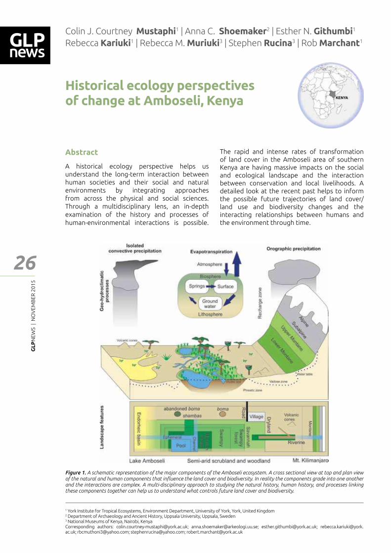
GL
PN
EWS
| N
OV
EMB
ER 2
01
5
26
Historical ecology perspectives of change at Amboseli, Kenya
Colin J. Courtney Mustaphi1 | Anna C. Shoemaker2 | Esther N. Githumbi1 Rebecca Kariuki1 | Rebecca M. Muriuki3 | Stephen Rucina3 | Rob Marchant1
1 York Institute for Tropical Ecosystems, Environment Department, University of York, York, United Kingdom2 Department of Archaeology and Ancient History, Uppsala University, Uppsala, Sweden3 National Museums of Kenya, Nairobi, KenyaCorresponding authors: [email protected]; [email protected]; [email protected]; [email protected]; [email protected]; [email protected]; [email protected]
Figure 1. A schematic representation of the major components of the Amboseli ecosystem. A cross sectional view at top and plan view of the natural and human components that in┅uence the land cover and biodiversity. In reality the components grade into one another and the interactions are complex. A multi-disciplinary approach to studying the natural history, human history, and processes linking these components together can help us to understand what controls future land cover and biodiversity.
Abstract
A historical ecology perspective helps us understand the long-term interaction between human societies and their social and natural environments by integrating approaches from across the physical and social sciences. Through a multidisciplinary lens, an in-depth examination of the history and processes of human-environmental interactions is possible.
The rapid and intense rates of transformation of land cover in the Amboseli area of southern Kenya are having massive impacts on the social and ecological landscape and the interaction between conservation and local livelihoods. A detailed look at the recent past helps to inform the possible future trajectories of land cover/land use and biodiversity changes and the interacting relationships between humans and the environment through time.
Feat
ure
- Art
icle
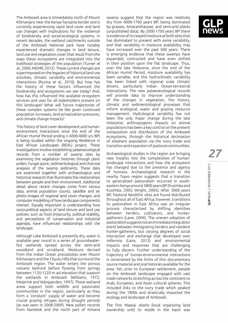
GL
PN
EWS
| N
OV
EMB
ER 2
01
5
27
Feat
ure
- Art
icle
The Amboseli area is immediately north of Mount Kilimanjaro near the Kenya-Tanzania border and is currently experiencing rapid land cover and land use changes with implications for the resilience of biodiversity and social-ecological systems. In recent decades, the wetland catchments outside of the Amboseli National park have notably experienced dramatic changes in land tenure, land use and vegetation cover that result from the ways these ecosystems are integrated into the livelihood strategies of the population (Turner et al., 2000; MEMR, 2012). These current changes are superimposed on the legacies of historical land use activities, climatic variability and environmental interactions (Rucina et al., 2010). But how has the history of these factors in┅uenced the biodiversity and ecosystems we see today? And, how has this in┅uenced the available ecosystem services and uses for all stakeholders present on this landscape? What will future trajectories of these complex systems be like given continued population increases, land privatization pressures, and climate change impacts?
This history of land cover development and human-environment interactions since the end of the African Humid Period ending (~6000-4000 yrs BP) is being studied within the ongoing Resilience in East African Landscapes (REAL) project. These investigations involve establishing palaeoecological records from a number of swamp sites by examining the vegetation histories through plant pollen, fungal spore, sedimentological and charcoal analyses of the swamp sediments. These data are examined together with archaeological and historical research that illuminates the relationships between people and their environment. Additional detail about recent changes come from census data, animal population counts, satellite and air photo images of regional land cover changes, and computer modelling of how landscape components interact. Equally important is understanding how socio-political aspects of land tenure and land use policies, such as food (in)security, political stability, and perceptions of conservation and industrial agendas, have in┅uenced relationships with the landscape.
Although Lake Amboseli is presently dry, water is available year round in a series of groundwater-fed wetlands spread across the semi-arid woodland and scrubland. Moisture derived from the Indian Ocean precipitates over Mount Kilimanjaro and the Chyulu Hills that surround the Amboseli region. The water enters the porous volcanic bedrock before ┅owing from springs between 1120-1220 m asl elevation that support the wetlands in Amboseli (Williams, 1972; Meijerink and Wijngaarden, 1997). These wetland areas support both wildlife and pastoralist communities in the region, particularly as they form a �constant� supply of water and become crucial grazing refuges during drought periods (as was seen in 2008-2009). New pollen records from Namelok and the north part of Kimana
swamp suggest that the region was relatively dry from 4000-1700 years BP, being dominated by grasses, Amaranthaceae, and semi-arid plants (unpublished data). By 2000-1700 years BP there is evidence of increased moisture at both sites that has dominated to present with some variability, and that variability in moisture availability may have increased over the past 500 years. There is emerging evidence that these swamps have expanded, contracted and have even shifted in their position upon the ┅at landscape. Thus, over the late Holocene, since the end of the African Humid Period, moisture availability has been variable, and this hydroclimatic variability has been linked with regional scale climatic drivers, particularly Indian Ocean-terrestrial interactions. The new palaeoecological records will provide data to improve understanding of the changes in vegetation, ┃re history, climatic and sedimentological processes that inform ecological, water and grazing resource management. Hydrological variability has not been the only major change during the late Holocene; anthropogenic impacts on animal populations has been a key control on the present composition and distribution of the Amboseli ecosystems, through the historical decimation of elephant population via the ivory trade and transition and expansion of pastoral communities.
Archaeological studies in the region are bringing new insights into the complexities of human-landscape interactions and how the ecosystem has changed due to the presence and agency of humans. Archaeological research in the nearby Tsavo region suggests that a transition to generalized pastoralism occurred in south-eastern Kenya around 3800 years BP (Kusimba and Kusimba, 2005; Wright, 2005). After 3000 years BP, Pastoral Neolithic sites are found distributed throughout all of East Africa; however, transitions to pastoralism in East Africa was an irregular process characterized by shifting identities between herders, cultivators, and hunter-gatherers (Lane, 2004). The uneven adoption of pastoralism suggests not an immediate integration event between immigrating herders and resident hunter-gatherers, but varying degrees of social interaction and exchange that developed over millennia (Lane, 2013) and environmental impacts and responses that are challenging to fully discern. Further understanding of the trajectory of human-environmental interactions is constrained by the limits of thin documentary source material and oral histories available for the area. Yet, prior to European settlement, people on the Amboseli landscape engaged with vast trade networks stretching across the continent to Arab, European, and Asian cultural spheres. This included links to the ivory trade which peaked during the 1800s and drastically impacted the ecology and landscape of Amboseli.
The ┃rst Maasai olosho (local organizing land ownership unit) to reside in the basin was
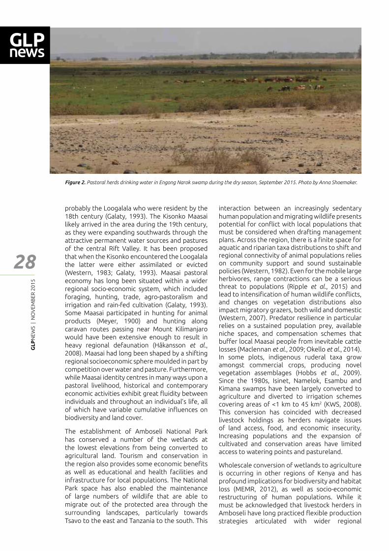
GL
PN
EWS
| N
OV
EMB
ER 2
01
5
28
probably the Loogalala who were resident by the 18th century (Galaty, 1993). The Kisonko Maasai likely arrived in the area during the 19th century, as they were expanding southwards through the attractive permanent water sources and pastures of the central Rift Valley. It has been proposed that when the Kisonko encountered the Loogalala the latter were either assimilated or evicted (Western, 1983; Galaty, 1993). Maasai pastoral economy has long been situated within a wider regional socio-economic system, which included foraging, hunting, trade, agro-pastoralism and irrigation and rain-fed cultivation (Galaty, 1993). Some Maasai participated in hunting for animal products (Meyer, 1900) and hunting along caravan routes passing near Mount Kilimanjaro would have been extensive enough to result in heavy regional defaunation (Håkansson et al., 2008). Maasai had long been shaped by a shifting regional socioeconomic sphere moulded in part by competition over water and pasture. Furthermore, while Maasai identity centres in many ways upon a pastoral livelihood, historical and contemporary economic activities exhibit great ┅uidity between individuals and throughout an individual�s life, all of which have variable cumulative in┅uences on biodiversity and land cover.
The establishment of Amboseli National Park has conserved a number of the wetlands at the lowest elevations from being converted to agricultural land. Tourism and conservation in the region also provides some economic bene┃ts as well as educational and health facilities and infrastructure for local populations. The National Park space has also enabled the maintenance of large numbers of wildlife that are able to migrate out of the protected area through the surrounding landscapes, particularly towards Tsavo to the east and Tanzania to the south. This
Figure 2. Pastoral herds drinking water in Engong Narok swamp during the dry season, September 2015. Photo by Anna Shoemaker.
interaction between an increasingly sedentary human population and migrating wildlife presents potential for con┅ict with local populations that must be considered when drafting management plans. Across the region, there is a ┃nite space for aquatic and riparian taxa distributions to shift and regional connectivity of animal populations relies on community support and sound sustainable policies (Western, 1982). Even for the mobile large herbivores, range contractions can be a serious threat to populations (Ripple et al., 2015) and lead to intensi┃cation of human wildlife con┅icts, and changes on vegetation distributions also impact migratory grazers, both wild and domestic (Western, 2007). Predator resilience in particular relies on a sustained population prey, available niche spaces, and compensation schemes that bu━er local Maasai people from inevitable cattle losses (Maclennan et al., 2009; Okello et al., 2014). In some plots, indigenous ruderal taxa grow amongst commercial crops, producing novel vegetation assemblages (Hobbs et al., 2009). Since the 1980s, Isinet, Namelok, Esambu and Kimana swamps have been largely converted to agriculture and diverted to irrigation schemes covering areas of <1 km to 45 km2 (KWS, 2008). This conversion has coincided with decreased livestock holdings as herders navigate issues of land access, food, and economic insecurity. Increasing populations and the expansion of cultivated and conservation areas have limited access to watering points and pastureland.
Wholescale conversion of wetlands to agriculture is occurring in other regions of Kenya and has profound implications for biodiversity and habitat loss (MEMR, 2012), as well as socio-economic restructuring of human populations. While it must be acknowledged that livestock herders in Amboseli have long practiced ┅exible production strategies articulated with wider regional
Feat
ure
- Art
icle
GL
PN
EWS
| N
OV
EMB
ER 2
01
5
29
Feat
ure
- Art
icle
References
Galaty, J.G. (1993). Maasai Expansion and the New East African Pastoralism. In T. Spear and R. Waller (eds.) Being Maasai: Ethnicity and Identity in East Africa. James Currey, London. Pp 61-86.
Håkansson, T., Widgren, M., & Börjeson, L. (2008). Introduction: Historical and Regional Perspectives on Landscape Transformations in Northeastern Tanzania, 1850-2000. International Journal of African Historical Studies 41 (3), 369-382.
Hobbs, R.J., Higgs, E., & Harris, J.A. (2009). Novel ecosystems: implications for conservation and restoration. Trends in ecology & evolution 24(11), 599-605.
Kusimba, C.M. & Kusimba, S.B. (2005). Mosaics and interactions: East Africa 2000 B.P. to the present. In A.B. Stahl (ed.) African Archaeology: A Critical Introduction. Oxford: Blackwell. Pp. 392-419.
KWS. (2008) Amboseli Ecosystem Management Plan, 2008-2018. Nairobi, Kenya.
Lane, P. (2004). The Moving Frontier: and the Transition to Food Production in Kenya. Azania 39: 243-264.
Lane, P. (2013). The Archaeology of Pastoralism in Northern and Central Kenya. In M. Bollig, M. Schnegg, and H.P. Wotzka (eds.) Pastoralism in Africa: Past, Present, and Future. Berghahn Books, New York and Oxford. Pp. 104-144.
Maclennan, S.D., Groom, R.J., Macdonald, D.W., & Frank, L.G. (2009). Evaluation of a compensation scheme to bring about pastoralist tolerance of lions. Biological Conservation 142, 2419-2427.
MEMR (2012). Kenya Wetlands Atlas. Nairobi: MEMR.
Meijerink, A.M.J., & Wijngaarden, W. (1997). Contribution to the groundwater hydrology of the Amboseli ecosystem, Kenya. Groundwater/surface water ecotones: biological and hydrological interactions and management options. Cambridge University Press. Pp 111-118.
Meyer, H. (1900). Der Kilimandjaro. Berlin, Dietrich Reimer.
Okello, M.M., Bonham, R., & Hill, T. (2014). The pattern and cost of carnivore predation on livestock in Maasai homesteads of Amboseli ecosystem, Kenya: Insights from a carnivore compensation programme. International Journal of Biodiversity and Conservation 6, 502-521.
Ripple, W.J., Newsome, T.M., Wolf, C., Dirzo, R., Everatt, K.T., Galetti, M., Hayward, M.W., et al. (2015). Collapse of the world�s largest herbivores. Science Advances 1, e1400103.
Rucina, S.M., Muiruri, V.M., Downton, L., Marchant, R., (2010). Late-Holocene savannah dynamics in the Amboseli Basin, Kenya. The Holocene 20, 667�677.
Turner, R.K., van der Bergh, C.J.C.M., Soderqvist, T., Barendregt, A., van der Straaten, J., Maltby, E., & van Ierland, E.C. (2000). Ecological-economic analysis of wetlands: scienti┃c integration for management and policy. Ecological Economics 35, 7–23.
Western, D. (1982). Amboseli National Park: Enlisting landowners to conserve migratory wildlife. Ambio 11, 302�308.
Western, D. (1983). A Wildlife Guide and a Natural History of Amboseli. General Printers, Nairobi.
Western, D. (2007). A half a century of habitat change in Amboseli National Park, Kenya. African Journal of Ecology 45, 302�310.
Williams, L.A.J. (1972). Geology of the Amboseli area. Ministry of Natural Resources, Geological Survey of Kenya, Report No. 90. Degree Sheet 59, SW Quarter. Government Printer: Nairobi.
Wright, D.K. (2005). New Perspectives on Early Regional Interaction Networks of East African Traded: A View from Tsavo National Park, Kenya. African Archaeological Review 22: 111-140.
markets, the rate of expansion of cultivated land in recent years is unprecedented in the area. The growth of the agricultural sector in Amboseli has had enormous impacts on wetland areas and human-environment interactions. The impacts of these changes directly in┅uence biodiversity at the genetic to population levels through changes in soil characteristics, habitat conversion and loss, human pressures, and reductions in natural connectivity of populations and associated gene pools. The consequences of such changes are reduced ecological resilience and curtailed capacity for ecosystem restoration and recovery of animal populations from increasing intensive and pervasive limitations to water access during droughts. Additionally, the present trend toward privatization of land in Amboseli continues to restrict land access and the poorly regulated process of subdivision and sale is exacerbating disparities in wealth accumulation and provisioning of social services. Social consequences also include
changes in the relationship between people and their livestock. As land use strategies shift, cattle holdings in Amboseli are declining and sheep and goat populations increasing. This has enormous implications for perceptions of identity for the Maasai in Amboseli who espouse that their cattle are the essence of their ┃nancial, nutritional, and cultural security. Understanding the history and development of human-environmental interactions plays a crucial role in understanding how the social-ecological system in Amboseli has evolved. Such a historical ecology perspective is being used to guide project future land cover/land use changes in the region to inform developments in sustainable human livelihoods and strengthen conservation objectives of the globally important Amboseli landscape.
For more information about the project, see: www.real-project.eu

GL
PN
EWS
| N
OV
EMB
ER 2
01
5
30
Environmental change and Water Ecosystem Services in the Bolivian Amazon Lowlands (Llanos de Moxos)
Abstract
The Llanos de Moxos is a vast savanna ┅oodplain located in Southwest Amazon. Like other wetlands in Amazonia, the Llanos de Moxos, because of its size and remoteness, is poorly monitored, while it is believed to be a vital piece of the overall health of the entire Amazon ecosystem. In this contribution, we perform an initial characterization of the Water Ecosystem Services in this unique region, we identify the main environmental change threats and introduce key concepts and research needs for addressing vulnerability. We found that the ecological and socio-political particularities of the Llanos de Moxos together with the lack of pertinent information, makes vulnerability research a challenging task. It demands a clear conceptualization, terminology, scope and methods to make vulnerability assessments a useful input for planning adaptation-mitigation or sustainable development.
Earth System Science Center CCST, National Institute for Space Research (INPE)Corresponding author: [email protected] The convention on Wetlands, called the Ramsar Convention, is an intergovernmental treaty that provides the framework for national action and international cooperation for the conservation and wise use of wetlands and their resources (http://www.ramsar.org/)
Alex Ovando1 | Graciela Tejada1 | Javier Tomasella1
multiple services they provide (Bolee, 2011). One of the major Amazonian wetlands is the �Llanos de Moxos”, which is a vast savanna ┅oodplain of approximately 150000 km2 (Hamilton et al., 2004) located in the Mamoré-Beni-Guaporé (Iténez) rivers ┅uvial system in Bolivia, between the eastern Andes, the adjacent Amazon alluvial fans and the Precambrian Brazilian shield (Figure 1). The mean altitude at the �Llanos� is approximately 150 m with a mean slope less than 10 cm per km (Guyot, 1993). The natural vegetation is mixed: grassland and savannah vegetation in seasonally ┅ooded areas, and evergreen tropical forests in non-┅ooded areas, although deforestation has converted part of the forest areas to pasture (Hamilton et al, 2004).
Like other wetlands in Amazonia, the �Llanos�, because of their extension and remoteness, are poorly monitored. The Llanos de Moxos are believed to be a vital piece of the overall ecological health of the entire Amazon and it has recently been designated by the Ramsar Conventiona as a wetland of international importance (WWF, 2013). The multiple Water Ecosystem Services that they provide are not yet properly characterized and quanti┃ed. Also, the environmental change impacts in the hydrological cycle, that may compromise these ecosystems functions and services, are still poorly known.
In this contribution we provide an initial characterization of the Water Ecosystem Services in the Llanos de Moxos, identifying the main environmental changes and threats to the ecosystems. Finally, we introduce key concepts and research needs for addressing vulnerability in the area.
Water Ecosystem Services in the Bolivian Amazon wetlands
Ongoing research regarding ┅ood dynamics in the Llanos (Ovando et al., 2015) show that ┅ood peaks (covering up to 71305 km2) tend to
Feat
ure
- Art
icle
Introduction
Freshwater is considered as the �bloodstream� of the biosphere, driving critical processes and functions in forests, woodlands, wetlands, grasslands, croplands and other terrestrial ecosystems while keeping them resilient to change (Falkenmark, 2003). Wetlands, besides providing fresh water, regulation and cultural services, support a rich biodiverstity, as well as human populations. Water is a key driver in the delivery of many ecosystem services, including provisioning services (domestic use, irrigation, power generation and transportation), as well as supporting, regulatory and cultural services (Aylward et al., 2005; Bolee, 2011).
Human livelihood and wellbeing, along the Amazon, is strongly dependent on the local landscape, ecosystem functionality and the
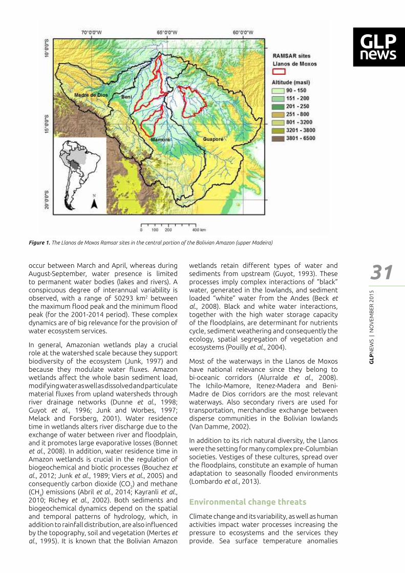
GL
PN
EWS
| N
OV
EMB
ER 2
01
5
31
Feat
ure
- Art
icle
occur between March and April, whereas during August-September, water presence is limited to permanent water bodies (lakes and rivers). A conspicuous degree of interannual variability is observed, with a range of 50293 km2 between the maximum ┅ood peak and the minimum ┅ood peak (for the 2001-2014 period). These complex dynamics are of big relevance for the provision of water ecosystem services.
In general, Amazonian wetlands play a crucial role at the watershed scale because they support biodiversity of the ecosystem (Junk, 1997) and because they modulate water ┅uxes. Amazon wetlands a━ect the whole basin sediment load, modifying water as well as dissolved and particulate material ┅uxes from upland watersheds through river drainage networks (Dunne et al., 1998; Guyot et al., 1996; Junk and Worbes, 1997; Melack and Forsberg, 2001). Water residence time in wetlands alters river discharge due to the exchange of water between river and ┅oodplain, and it promotes large evaporative losses (Bonnet et al., 2008). In addition, water residence time in Amazon wetlands is crucial in the regulation of biogeochemical and biotic processes (Bouchez et al., 2012; Junk et al., 1989; Viers et al., 2005) and consequently carbon dioxide (CO
2) and methane
(CH4) emissions (Abril et al., 2014; Kayranli et al.,
2010; Richey et al., 2002). Both sediments and biogeochemical dynamics depend on the spatial and temporal patterns of hydrology, which, in addition to rainfall distribution, are also in┅uenced by the topography, soil and vegetation (Mertes et al., 1995). It is known that the Bolivian Amazon
wetlands retain di━erent types of water and sediments from upstream (Guyot, 1993). These processes imply complex interactions of �black� water, generated in the lowlands, and sediment loaded �white� water from the Andes (Beck et al., 2008). Black and white water interactions, together with the high water storage capacity of the ┅oodplains, are determinant for nutrients cycle, sediment weathering and consequently the ecology, spatial segregation of vegetation and ecosystems (Pouilly et al., 2004).
Most of the waterways in the Llanos de Moxos have national relevance since they belong to bi-oceanic corridors (Alurralde et al., 2008). The Ichilo-Mamore, Itenez-Madera and Beni-Madre de Dios corridors are the most relevant waterways. Also secondary rivers are used for transportation, merchandise exchange between disperse communities in the Bolivian lowlands (Van Damme, 2002).
In addition to its rich natural diversity, the Llanos were the setting for many complex pre-Columbian societies. Vestiges of these cultures, spread over the ┅oodplains, constitute an example of human adaptation to seasonally ┅ooded environments (Lombardo et al., 2013).
Environmental change threats
Climate change and its variability, as well as human activities impact water processes increasing the pressure to ecosystems and the services they provide. Sea surface temperature anomalies
Figure 1. The Llanos de Moxos Ramsar sites in the central portion of the Bolivian Amazon (upper Madeira)
GL
PN
EWS
| N
OV
EMB
ER 2
01
5
32
in┅uence extreme ┅ood events in the Bolivian Amazon (Ronchail et al., 2005). For example, the unprecedented rainfall over the Madeira Basin during the rainy season of 2013-2014, was related to warm conditions in the Paci┃c-Indian and sub-tropical south Atlantic, and exceptional warm conditions in the Atlantic Ocean, which favored the humidity transport over South western Amazonia (Espinoza et al., 2014). The increased frequency of extremes in the Amazon has led Gloor et.al. (2013) to suggest an intensi┃cation of the hydrological cycle starting from the 1990s, which is responsible for �progressively greater di━erences in Amazon peak and minimum ┅ows”.
It has been shown that these extreme events have the potential to cause serious disruptions in the ecological functioning of the Amazon forest ecosystems (Phillips et al., 2009) and alter the normal functioning of the wetlands, pushing the physiological adaptations and behavioral changes of living organisms beyond their resilience limits (Junk, 2013). In addition, they compromise the livelihoods of riverine communities, which are dependent on the ┅ood pulses (Tomasella et al., 2013).
According to Seiler et al. (2013) who had analyzed 35 Global Circulation Models (GCMs) from the 3rd and 5th Coupled Inter-comparison Project (CMIP3/5), the Bolivian Lowlands are likely to have an annual precipitation decrease of 9% for the 2010-2099, this reduction attain to 19% during drier months (June to November). Results from Regional Circulation Models in Bolivia (Seiler, 2009) exhibits an accentuation of the precipitation regime in the lowlands: more precipitation during the rainy season and less precipitation during the dry season. Severe economic and social impacts were reported after extreme events of 2007, 2008 and 2014 in the Bolivian lowlands (CEPAL, 2008; UDAPE, 2015), but little is known about impacts in the ecosystems.
Land change may potentially impact precipitation, river discharge and groundwater recharge in di━erent forms, intensities and scales, as demonstrated by (Coe et al., 2009; D�Almeida et
al., 2007; Davidson et al., 2012; Mei and Wang, 2009; Sampaio et al., 2007; Siqueira-Júnior et al., 2015). Deforestation in the Bolivian lowlands between 2000-2010 achieved 1.8 Million ha, being 56% in the central portion of the Bolivian Amazon (Cuéllar et al., 2012). According to Tejada et al. (2015), deforestation for a �Fragmentation Scenario� in 2050, based on a high land demand for agricultural expansion, oil exploration, and road construction, might a━ect 41% of the Bolivian Amazon basin (Figure 2). It is clear then, that identifying deforestation impacts in the wetlands hydrology is a pending task.
Sediment load and transport into the river systems following deforestation and mining
activities may derive in water pollution with severe impacts on ecosystems and public health. Sediments from deforested areas in medium and upper portions of the watersheds are deposited in large ┅oodplain environments activating mercury pollution (Acha et al., 2005; Maurice-Bourgoin et al., 2000; Ovando, 2012).
Roads constitute a signi┃cant hazard for ecosystems functionality and hydrology as well as a major driving factor for land use changes. In general, linear structures like roads, highways, power lines and gas lines interacts with natural stream networks at the landscape scale, this interaction may impact biological and ecological processes in stream and riparian systems (Jones et al., 2000). The major ecological e━ects of roads, according to Forman and Alexander (1998), are: species disturbance, fragmentation of habitats and hydrologic and erosion e━ects. The bi-oceanic corridor and the highway across the TIPNIS (Territorio Indigena y Parque Nacional Isiboro-Secure) protected area are examples of current road projects, under the Initiative for the Integration of South American Infrastructure (IIRSA) (www.iirsa.org), with undetermined impacts in the Llanos de Moxos.
Also under IIRSA, massive hydroelectric dams are operating or in their initial projecting stages. The Cachuela Espezanza dam in the Beni River, Hidroelectrica Binacional dam in the Madera River and Rositas in the Rio Grande River are the most representative dam projects in the Bolivian Amazon. In the Brazilian side, Santo Antonio and Jirau dams are already in operation. Dams in the region may impact the wetlands functionality in several ways: changes in water stage (level) can be observed even hundreds of kilometers upstream, with a consequent loss in ┅ow velocity that could alter ┅ood dynamics in a large area (Pouilly et
al., 2009a); Sediment ┅ow may be constrained deriving in enhanced sediment deposition-transformation and then mercury pollution (Pérez et al., 2009). The spread of vector borne diseases like malaria, leishmanioses, dengue, yellow fever and others may be enhanced since large areas may remain ┅ooded for more time (Arnéz, 2009); The natural cycles of organic matter decomposition in ┅oodplains may increase greenhouse gases emissions (CO
2 and CH
4) (Pouilly et al., 2009b); The
dams will form an arti┃cial barrier to ┃sh migration and mobilization, impacting on ┃sh spawning–reproduction and local economy (Van Damme et
al., 2010). Even dams in the Andean Amazon zone may alter the connectivity between Andes and the ┅oodplains (Finer and Jenkins, 2012). With these examples, we can see that relevant e━orts had been done to understand the potential impacts of dams; but a comprehensive evaluation of the applicability of dams, considering the wetland functionality and the Andes-Amazon connectivity, is still a critical need.
Feat
ure
- Art
icle
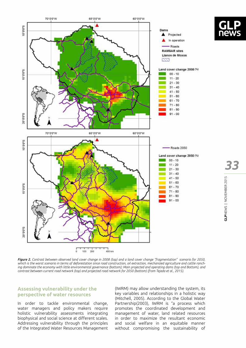
GL
PN
EWS
| N
OV
EMB
ER 2
01
5
33
Feat
ure
- Art
icle
Assessing vulnerability under the perspective of water resources
In order to tackle environmental change, water managers and policy makers require holistic vulnerability assessments integrating biophysical and social science at di━erent scales. Addressing vulnerability through the principles of the Integrated Water Resources Management
(IWRM) may allow understanding the system, its key variables and relationships in a holistic way (Mitchell, 2005). According to the Global Water Partnership(2003), IWRM is �a process which promotes the coordinated development and management of water, land related resources in order to maximize the resultant economic and social welfare in an equitable manner without compromising the sustainability of
Figure 2. Contrast between observed land cover change in 2008 (top) and a land cover change �fragmentation� scenario for 2050, which is the worst scenario in terms of deforestation since road construction, oil extraction, mechanized agriculture and cattle ranch-ing dominate the economy with little environmental governance (bottom); Main projected and operating dams (top and Bottom), and contrast between current road network (top) and projected road network for 2050 (bottom) (from Tejada et al., 2015).
GL
PN
EWS
| N
OV
EMB
ER 2
01
5
34
Abril, G., Martinez, J.-M., Artigas, L.F., Moreira-Turcq, P., Benedetti, M.F., Vidal, L., Meziane, T., Kim, J.-H., Bernardes, M.C., Savoye, N., 2014. Amazon River carbon dioxide outgassing fuelled by wetlands. Nature 505, 395�398. doi:10.1038/nature12797
Acha, D., Iniguez, V., Roulet, M., Guimaraes, J.R.D., Luna, R., Alanoca, L., Sanchez, S., 2005. Sulfate-Reducing Bacteria in Floating Macrophyte Rhizospheres from an Amazonian Floodplain Lake in Bolivia and Their Association with Hg Methylation. Appl. Environ. Microbiol. 71, 7531�7535. doi:10.1128/aem.71.11.7531-7535.2005
Alurralde, J.C., Campanini, O., Herbas, R., Van Damme, P.A., Diaz, carlos, Vargas, C., 2008. El agua en Bolivia - Documento de trabajo.
Arnéz, A.M., 2009. El impacto de la construcción de represas en las enfermedades de transmisión vectorial, in: Arnéz, A.M., Mamani, E., Novoa;, G., Molina, J., Ledezma, F., Vauchel, P., Canese, R. (Eds.), Bajo El Caudal- El Impacto de Las Represas Del Rio Madera En Bolivia. Foro Boliviano de Madio Ambiente FOBOMADE, La Paz-Bolivia.
Aylward, B., Bandyopadhyay, J., Belausteguigotia, J.-C., 2005. Freshwater ecosystem services, in: In Ecosystems and Human Well-Being: Policy Responses, Volume 3. Millennium Ecosystem Assessment. Island Press, Washington, Covelo and London, and www.maweb.org.
Beck, S., Zenteno-Ruiz, F., López R., Larrea-Alcázar, D., Uzquiano, J., Antezana, A., 2008. �Estudio del impacto del fenómeno ENSO (El niño Oscilación del Sur) en la diversidad biológica de Beni y Pando.�
Bellamy JA, Johnson, A.K.L., 2000. Integrated resource management: moving from rhetoric to practice in Australian agriculture. Environ. Manage. 25, 265�280.
Bolee, E. (ed), 2011. Ecosystems for water and food security. Nairobi: United Nations Environment Programme Colombo: International Water Management Institute.
Bonnet, M.P., Barroux, G., Martinez, J.M., Seyler, F., Moreira-Turcq, P., Cochonneau, G., Melack, J.M., Boaventura, G., Maurice-Bourgoin, L., León, J.G., Roux, E., Calmant, S., Kosuth, P., Guyot, J.L., Seyler, P., 2008. Floodplain hydrology in an Amazon ┅oodplain lake (Lago Grande de Curuaí¬). J. Hydrol. 349, 18–30. doi:http://dx.doi.org/10.1016/j.jhydrol.2007.10.055
vital ecosystems�. IWRM makes possible to link environmental change with aspects of water use, water quality, management, conservation, ecosystem functionality, social-cultural values and the relevance of institutions relating to water (Bellamy JA and Johnson, 2000; Plummer et al., 2012). It is a broad axis for analysis, it encompasses a wide and holistic range of potential impacts with many subsystems and particular impacts to take into account in function of the scale of study and actors perceptions.
It is noticeable that, in the context of global environmental change, the relevance of non-climatic factors is growing concern; initially non-climatic factors were limited to a socio-economic domain, then the term �non-climatic drivers� is included accounting for demographic, economic, technologic and biophysical drivers (Füssel and Klein, 2006). As we saw in previous sections, there is much more than climate change threatening the Llanos de Moxos. We found that most of the initiatives for addressing vulnerability in Bolivian lowlands are focused mainly in climate change drivers. This means that it is necessary to include a wider set of non-climatic factors in order to highlight potential aggregated impacts, especially when addressing water resources.
Pertinent socio-economic and physical information is required to assess vulnerability. Quantitative
and qualitative information about water ecosystem services are of primary importance. Hydrologic-hydrodynamic models together with stream┅ow data may provide spatial information about provisioning services. Information for regulatory, cultural and supporting services is limited, constituting a relative new ┃eld of research that needs to be promoted. An accurate representation of the hydrological-hydrodynamic processes may derive in simulations under di━erent scenarios of climate change-variability, land use and water management, providing the possibility to estimate their impacts on water ecosystem services.
The socio-political particularities of the Llanos de Moxos together with the lack of pertinent information, makes vulnerability research a challenging task. It demands a clear conceptualization, terminology, scope and methods to make their results a useful input for planning adaptation-mitigation or sustainable development. We highlight the helpfulness of the concepts and structure of the Integrated Water Resources Management for facing vulnerability in the Bolivian Amazon wetlands, where the state of conservation of its ecosystems constitutes a collective heritage.
References
Feat
ure
- Art
icle
GL
PN
EWS
| N
OV
EMB
ER 2
01
5
35
Feat
ure
- Art
icle
Bouchez, J., Gaillardet, J., Lupker, M., Louvat, P., France-Lanord, C., Maurice, L., Armijos, E., Moquet, J.-S., 2012. Floodplains of large rivers: Weathering reactors or simple silos? Chem. Geol. 332�333, 166�184. doi:10.1016/j.chemgeo.2012.09.032
CEPAL, 2008. Evaluacion del Impacto Acumulado y Adicional Ocacionado por la Niña 2008 en Bolivia. Ministerio de Plani┃cación del Desarrollo (MPD) de Bolivia, Secretaría Ejecutiva de la Comisión Económica para América Latina y el Caribe (CEPAL), La Paz-Bolivia.
Coe, M.T., Costa, M.H., Soares-Filho, B.S., 2009. The in┅uence of historical and potential future deforestation on the stream ┅ow of the Amazon River “ Land surface processes and atmospheric feedbacks. J. Hydrol. 369, 165–174.
Cuéllar, S., Rodríguez, A., Arroyo, J., Espinoza, S., Larrea, D.M., 2012. Mapa de Deforestacion de las Tierras Bajas y Yungas de Bolivia 2000-2005-2010. doi:http://www.sayubu.com/fan/?p=1490
D’Almeida, C., Vörösmarty, C.J., Hurtt, G.C., Marengo, J.A., Dingman, S.L., Keim, B.D., 2007. The e━ects of deforestation on the hydrological cycle in Amazonia: a review on scale and resolution. Int. J. Climatol. 27, 633�647. doi:10.1002/joc.1475
Davidson, E.A., de Araujo, A.C., Artaxo, P., Balch, J.K., Brown, I.F., C. Bustamante, M.M., Coe, M.T., DeFries, R.S., Keller, M., Longo, M., Munger, J.W., Schroeder, W., Soares-Filho, B.S., Souza, C.M., Wofsy, S.C., 2012. The Amazon basin in transition. Nature 481, 321�328.
Dunne, T., Mertes, L.A.K., Meade, R.H., Richey, J.E., Forsberg, B.R., 1998. Exchanges of sediment between the ┅ood plain and channel of the Amazon River in Brazil. Geol. Soc. Am. Bull. 110, 450�467. doi:10.1130/0016-7606(1998)110<0450:eosbtf>2.3.co;2
Espinoza, J.C., Marengo, J.A., Ronchail, J., Molina, J., Noriega, L., Guyot, J.L., 2014. The extreme 2014 ┅ood in south-western Amazon basin: the role of tropical-subtropical South Atlantic SST gradient. Environ. Res. Lett. 9, 124007.
Falkenmark, M., 2003. Freshwater as shared between society and ecosystems: from divided approaches to integrated challenges. Philos. Trans. R. Soc. London. Ser. B Biol. Sci. 358, 2037�2049. doi:10.1098/rstb.2003.1386
Finer, M., Jenkins, C.N., 2012. Proliferation of Hydroelectric Dams in the Andean Amazon and Implications for Andes-Amazon Connectivity. PLoS One 7, e35126. doi:10.1371/journal.pone.0035126
Forman, R., Alexander, L., 1998. Roads and Their Major Ecologycal E━ects. Annu. Rev. Ecol. Syst. 29.
Füssel, H.-M., Klein, R.T., 2006. Climate Change Vulnerability Assessments: An Evolution of Conceptual Thinking. Clim. Change 75, 301�329. doi:10.1007/s10584-006-0329-3
Global-Water-Partnership, 2003. E━ective water governance: learning from the dialogues. .
Gloor, M., Brienen, R.J.W., Galbraith, D., Feldpausch, T.R., Schöngart, J., Guyot, J., Espinoza, J.C., Lloyd, J., Phillips, O.L., 2013. Intensi┃cation of the Amazon hydrological cycle over the last two decades. Geophys. Res. Lett. 40, 1729–1733. doi:10.1002/grl.50377/full
Guyot, J.L., 1993. Hydrogéochemie des Fleuves de l�amazonie Bolivienne. Géologie Géochimie. Universite de Bourdeaux, Bourdeaux.
Guyot, J.L., Fillzola, N., Quintanilla, J., Cortez, J., 1996. Dissolved solids and suspended sediment yields in the Rio Madeira basin, from the Bolivian Andes to the Amazon. Eros. Sediment Yield Glob. Reg. Perspect.
Hamilton, S.K., Sippel, S.J., Melack, J.M., 2004. Seasonal inundation patterns in two large savanna ┅oodplains of South America: the Llanos de Moxos (Bolivia) and the Llanos del Orinoco (Venezuela and Colombia). Hydrol. Process. 18, 2103�2116. doi:10.1002/hyp.5559
Junk, W., 1997. General Aspects of Floodplain Ecology with Special Reference to Amazonian Floodplains, in: The Central Amazon Floodplain. Springer Berlin Heidelberg, pp. 3�20. doi:10.1007/978-3-662-03416-3_1
Junk, W., Worbes, M., 1997. The Forest Ecosystem of the Floodplains, in: The Central Amazon Floodplain. Springer Berlin Heidelberg, pp. 223�265. doi:10.1007/978-3-662-03416-3_11
Junk, W.J., Bayley, P.B., Sparks, R.E., 1989. The Flood Pulse Concept in River-Floodplain Systems, in: Dodge, D.P. (Ed.), Proceedings of the International Large River Symposium. Canadian Special Publication of Fisheries and Aquatic Sciences , Ontario-Canada, pp. 110�127.
Kayranli, B., Scholz, M., Mustafa, A., Hedmark, A., 2010. Carbon storage and ┅uxes within freshwater wetlands: a critical review. Wetlands 30, 111�124. doi:doi: 10.1007/s13157-009-0003-4
Lombardo, U., Denier, S., May, J.-H., Rodrigues, L., Veit, H., 2013. Human�environment interactions in pre-Columbian Amazonia: The case of the Llanos de Moxos, Bolivia. Quat. Int. 312, 109�119. doi:10.1016/j.quaint.2013.01.007
Maurice-Bourgoin, L., Quiroga, I., Chincheros, J., Courau, P., 2000. Mercury distribution in waters and ┃shes of the upper Madeira rivers and mercury exposure in riparian Amazonian populations. Sci. Total Environ. 260, 73�86.
Mei, R., Wang, G., 2009. Rain follows logging in the Amazon? Results from CAM3�CLM3. Clim. Dyn. 34, 983�996. doi:10.1007/s00382-009-0592-x
Melack, J.M., Forsberg, B., 2001. Biogeochemistry of Amazon ┅oodplain lakes and associated wetlands, in: McClain, M.E., Victoria, R.L., Richey, J.E. (Eds.), Biogeochemistry of the Amazon Basin and Its Role in a Changing World. Oxford Univ. Press, New York, pp. 235�276.
Mertes, L.A.K., Daniel, D.L., Melack, J.M., Nelson, B., Martinelli, L.A., Forsberg, B.R., 1995. Spatial patterns of hydrology, geomorphology, and vegetation on the ┅oodplain of the Amazon river in Brazil from a remote sensing perspective. Geomorphology 13, 215�232. doi:10.1016/0169-555X(95)00038-7
Mitchell, B., 2005. Integrated water resource management, institutional arrangements, and land-use planning. Environ. Plan. A 37, 1335�1352.
Ovando, A., 2012. Deforestacion e Inundaciones en la cuenca del rio Itenez como indicadores de la contaminacion por mercurio, in: Van Damme Maldonado, M. , Pouilly, M. , Doria, C., P.A. (Ed.), Aguas Del Itenez O Guapore, Recursos Hidrobiologicos de Un Patrimonio Binacional (Bolivia-Brasil). Editorial INIA, Cochabamba - Bolivia, pp. 59�78.
GL
PN
EWS
| N
OV
EMB
ER 2
01
5
36
Ovando, A., Tomasella, J., Rodrigues, D.A., Martinez, J.M., Siqueira Júnio, J.L., Pinto, G.L.N., Passy, P., Vauchel, P., Noriega, L., VonRandaw, C., 2015. Extreme ┅ood events in the Bolivian Amazon Wetlands, In press: J. Hydrol. Reg. Stud. doi: 10.1016/j.ejrh.2015.11.004
Pérez, T., Pouilly, M., Maurice, L., Paco, P., Ovando, A., Córdova, L., 2009. Sensibilidad del Norte Amazónico a la contaminación por el Mercurio. SIRENARE Sistema de Rregulación de Recuros Natiurales Renovables, La Paz - Bolivia.
Plummer, R., Loe, R., Armitage, D., 2012. A Systematic Review of Water Vulnerability Assessment Tools. Water Resour. Manag. 26, 4327�4346. doi:10.1007/s11269-012-0147-5
Pouilly, M., Beck, S., Moraes, M., Ibañez, C., 2004. Diversidad Biológica de la Llanura de Inundación del Río Mamoré. Importancia Ecológica de la Dinámica Fluvial. Santa Cruz-Bolivia.
Pouilly, M., Córdova, L., Martinez, J.-M., Maurice, L., Molina, J., Ovando, A., WWF, 2009a. Escenarios de impactos geoquímicos y ecológicos consecuentes a los cambios hidrológicos en la cuenca alta del río Madera. Institut de Recherche pour le Développement (IRD, Francia), Instituto de Hidrología e Hidráulica - Universidad mayor de San Andres (La Paz), Unidad de Limnología y Recursos Acuáticos - Universidad Mayor de San Simón (Cochabamba), La Paz-Bolivia.
Pouilly, M., Martinez, J.M., Córdova, L., Pérez, T., Duprey, J.L., Caranzas, B., Ovando, A., Guérin, F., Abril, G., 2009b. Dinámica de inundación, emisión de gas y tasa de mercurio en peces en el Norte Amazónico boliviano.Hacia una cuanti┃cación de los impactos del proyecto hidroeléctrico del río Madera. nstitut de Recherche pour le Développement (IRD, Francia), Unidad de Limnología y Recursos Acuáticos - Universidad Mayor de San Simón (Cochabamba), Instituto de Ecologia - Universidad Mayor de San Andres (La Paz) .
Richey, J.E., Melack, J.M., Audenkampe, A.K., Ballester, V.M., Hess, L.L., 2002. Outgassing from Amazonian rivers and wetlands as a large tropical source of atmospheric CO2. Nature 416, 617�620. doi:10.1038/416617a
Ronchail, J., Bourrel, L., Cochonneau, G., Vauchel, P., Phillips, L., Castro, A., Guyot, J.-L., de Oliveira, E., 2005. Inundations in the Mamore basin (south-western Amazon - Bolivia) and sea-surface temperature in the Paci┃c and Atlantic Oceans. J. Hydrol. 302, 223�238. doi:http://dx.doi.org/10.1016/j.jhydrol.2004.07.005
Sampaio, G., Nobre, C., Costa, M.H., Satyamurty, P., Soares-Filho, B.S., Cardoso, M., 2007. Regional climate change over eastern Amazonia caused by pasture and soybean cropland expansion. Geophys. Res. Lett. 34, L17709. doi:10.1029/2007gl030612
Seiler, C., 2009. Función climática e hidrológica de la cobertura boscosa de Amboró-Carrasco y la Cuenca alta y media del Río Piraí en Bolivia.
Seiler, C., Hutches, R.W., Kabat, P.-, 2013. Likely Ranges of Climate Change in Bolivia. Appl. Meteor. Clim. doi:10.1175/JAMC-D-12-0224.1,
Siqueira-Júnior, J.L.S., Tomasella, J., Rodriguez, D.A., 2015. Impacts of future climatic and land cover changes on the hydrological regime of the Madeira River basin. Clim. Change 129, 117�129. doi:10.1007/s10584-015-1338-x
Tejada, G., Dalla-Nora, E., Cordova, D., Lafortezza, R., Ovando, A., Assis, T., Aguiar, A.P.P., Cordoba, D., Lafortezza, R., Ovando, A., Assis, T., Aguiar, A.P.P., 2015. Deforestation Scenarios for the Bolivian lowlands, In press: Environ. Res. Spetial issue �Provision Ecosyst. doi:10.1016/j.envres.2015.10.010
UDAPE, 2015. Evaluación de daño y perdidas por eventos climaticos - Bolivia 2013-2014. La Paz - Bolivia.
Van Damme, P.A., 2002. Disponibilidad, Uso y Calidad de los Recursos Hídricos en Bolivia.
Van Damme, P.A., Carvajal-Vallejos, F., Sarmiento, J., Beccerra, P., 2010. Vulnerabilidad de los peces de las tierras bajas de la Amazonia Boliviana, in: Van Damme, P.A., Carvajal, F., Molina, J. (Eds.), Los Peces de La Amazonía Boliviana: Hábitats, Potencialidades Y Amenazas. Faunagua, Cochabamba - Bolivia.
Viers, J., Barroux, G.G., Pinelli, M., Seyler, P., Oliva, P., Dupré, B., Boaventura, G.R., Dupré, B., Boaventura, G.R., 2005. The in┅uence of the Amazonian ┅oodplain ecosystems on the trace element dynamics of the Amazon River mainstem (Brazil). Sci. Total Environ. 339, 219�232. doi:10.1016/j.scitotenv.2004.07.034
WWF, 2013. Bolivia designates world�s largest protected wetland [WWW Document].
Feat
ure
- Art
icle
GL
PN
EWS
| N
OV
EMB
ER 2
01
5
37
Feat
ure
- Art
icle
Spatio-temporal patterns of forest recovery on abandoned arable land: ┃res and plant diversity
Maxim Bobrovsky1 I Larissa Khanina1
Abstract
Our hypothesis about the extremely important role of ┃res and vegetation surroundings in forest succession on the abandoned agricultural lands was tested on an example of former arable lands surrounded by old-growth broadleaf forests in the Kaluzhskie Zaseki State Nature Reserve in Russia. Results show that in the absence of ┃re and in the presence of stable seed ┅ow of plants inhabiting forest, about 95% of forest herbaceous species settle on former plowed lands in 25-30 years after their abandonment; all shade-tolerant trees and shrubs also steadily occur in the undergrowth. When ┃res a━ect abandoned lands, forest recovery is delayed for an undetermined time, although plant diversity can be higher than in a case without ┃re. When frequency and intensity of ┃re are increasing, the plant diversity begins to decrease and then falls sharply.
1 Institute of Physico-Chemical and Biological Problems of Soil Sciences of RAS, Institute of Mathematical Problems of Biology of RAS, Pushchino, Moscow region, RussiaCorresponding authors: [email protected]; [email protected]
Abandonment of agricultural land and subsequent natural regeneration to forest is happening in many regions in the world. In Russia, about 400,000 km2 of agricultural lands were abandoned between 1980 and 2000 (Ljuri et al., 2010); giving room to spontaneous reforestation. To predict vegetation development and to propose ecosystem management plans, it is important to understand that land abandonment is not a static end state but a transitional stage leading to di━erent pathways of varying intensity and long-term outcomes (Munroe et al., 2013).
The main process developing on the abandoned agricultural lands is plant succession leading to forest vegetation. It is generally known that main factors that in┅uence forest recovery are previous land use, soil properties and vegetation surroundings (Baeten et al., 2010; De Frenne et al., 2011; Fridley, Wright, 2012; Hou, Fu, 2014, etc.), whereas external in┅uences on the lands after abandonment are rarely considered in the literature. Our hypothesis is that intensity and frequency of external impacts such as grass ┃res,
grazing or recreation together with existence of steady seed ┅ow of forest plants are very important factors de┃ning the recovery process.
To test our hypothesis we selected a special site on the East-European plain located in the Kaluzhskie Zaseki State Nature Reserve (Kaluga region, Russia), where the absence of ┃res during the last 25 years could be established. A huge array of old-growth broadleaf forests dominated by Quercus robur, Fraxinus excelsior, Acer platanoides, A. campestre, Ulmus glabra and Tilia cordata surrounds some plowed ┃elds and pastures abandoned at the end of 80s of the 20th century due to the proclamation of the Reserve in 1992 there. Fire and livestock grazing have been completely absent on these lands since then. We chose these ┃elds as a ┃rst study site which we consider as a reference point. A second study site was former arable land also abandoned in the early 1990s where ┃res of di━erent frequency have been observed. This area is situated in 3 km from the ┃rst area, in a place bordering the Nature Reserve and also surrounded by old-growth broadleaf forest. Both areas have sod-podzolics soils (Albic Luvisols).
We studied plant diversity and spreading of broad-leaved trees and forest herbs in the study areas in 2012-2014 (Moskalenko, Bobrovsky, 2012, 2014).
Our results show that in the absence of ┃re and in the presence of stable seed ┅ow of forest plants, about 95% of herbaceous species from nearby old-growth forest settle on former plowed lands in 25-30 years after their abandonment; all shade-tolerant trees and shrubs also steadily occur in the undergrowth. With ┃res, forest recovery is delayed on the abandoned arable lands for an undetermined time, although plant diversity can be higher than in a case without ┃re.
In the ┃rst study area, in the absence of ┃res, we could distinguish the following steps of the forest recovery. At ┃rst, the pioneer tree species Betula pendula and B. pubescens (birch) with Salix
caprea (willow) full occupy the abandoned arable lands. Birch woods with willow pass a ┃rst stage
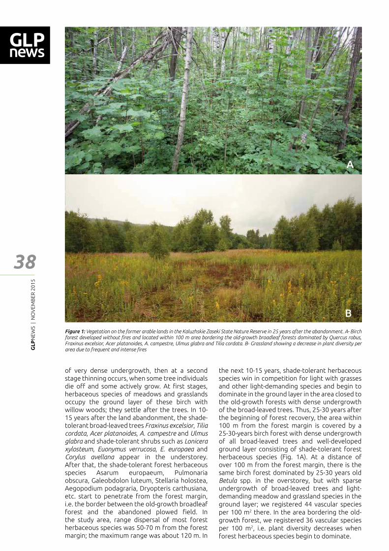
GL
PN
EWS
| N
OV
EMB
ER 2
01
5
38
of very dense undergrowth, then at a second stage thinning occurs, when some tree individuals die o━ and some actively grow. At ┃rst stages, herbaceous species of meadows and grasslands occupy the ground layer of these birch with willow woods; they settle after the trees. In 10-15 years after the land abandonment, the shade-tolerant broad-leaved trees Fraxinus excelsior, Tilia cordata, Acer platanoides, A. campestre and Ulmus glabra and shade-tolerant shrubs such as Lonicera xylosteum, Euonymus verrucosa, E. europaea and Corylus avellana appear in the understorey. After that, the shade-tolerant forest herbaceous species Asarum europaeum, Pulmonaria obscura, Galeobdolon luteum, Stellaria holostea, Aegopodium podagraria, Dryopteris carthusiana, etc. start to penetrate from the forest margin, i.e. the border between the old-growth broadleaf forest and the abandoned plowed ┃eld. In the study area, range dispersal of most forest herbaceous species was 50-70 m from the forest margin; the maximum range was about 120 m. In
the next 10-15 years, shade-tolerant herbaceous species win in competition for light with grasses and other light-demanding species and begin to dominate in the ground layer in the area closed to the old-growth forests with dense undergrowth of the broad-leaved trees. Thus, 25-30 years after the beginning of forest recovery, the area within 100 m from the forest margin is covered by a 25-30-years birch forest with dense undergrowth of all broad-leaved trees and well-developed ground layer consisting of shade-tolerant forest herbaceous species (Fig. 1A). At a distance of over 100 m from the forest margin, there is the same birch forest dominated by 25-30 years old Betula spp. in the overstorey, but with sparse undergrowth of broad-leaved trees and light-demanding meadow and grassland species in the ground layer; we registered 44 vascular species per 100 m2 there. In the area bordering the old-growth forest, we registered 36 vascular species per 100 m2, i.e. plant diversity decreases when forest herbaceous species begin to dominate.
A
Figure 1: Vegetation on the former arable lands in the Kaluzhskie Zaseki State Nature Reserve in 25 years after the abandonment. A- Birch forest developed without ┃res and located within 100 m area bordering the old-growth broadleaf forests dominated by Quercus robus, Fraxinus excelsior, Acer platanoides, A. campestre, Ulmus glabra and Tilia cordata. B- Grassland showing a decrease in plant diversity per area due to frequent and intense ┃res
Feat
ure
- Art
icle
B
GL
PN
EWS
| N
OV
EMB
ER 2
01
5
39
Feat
ure
- Art
icle
Figure 2: Biotops in the Zaokskii Section of the Serpukhov district located in the south of Moscow region
When ┃res a━ect abandoned lands, tree growth is delayed or terminated whereas plant diversity may be even higher than diversity of vegetation developing without ┃re. Various scenarios can be realized in depend on time of ┃res, its intensity and frequency. When grass ┃res are rare and do
not extend to large areas, some tree individuals can survive and light-demanding species can grow together with shade-tolerant ones due to light mosaic created by ┃re. In this case, total plant diversity increases: in the second study area, we registered about 50 vascular plants per 100 m2
GL
PN
EWS
| N
OV
EMB
ER 2
01
5
40
Feat
ure
- Art
icle
Baeten, L., Velghe, D., Vanhellemont, M., Frenne, P.D., Hermy, M., Verheyen, K. (2010). Early trajectories of spontaneous vegetation recovery after intensive agricultural land use. Restoration Ecology 18(S2): 379�386.
De Frenne, P., Baeten, L., Graae, B.J., Brunet, J., Wulf, M., Orczewska, A., Kolb, A., Jansen, I., Jamoneau, A., Jacquemyn, H., Hermy, M., Diekmann, M., De Schrijver, A., De Sanctis, M., Decocq, G., Cousins, S.O., Verheyen, K. (2011). Interregional variation in the ┅oristic recovery of post-agricultural forests. Journal of Ecology 99: 600–609.
Fridley, J.D., Wright, J.P. (2012). Drivers of secondary succession rates across temperate latitudes of the Eastern USA: climate, soils, and species pools. Oecologia 168: 1069�1077.
Hou, J., Fu, B. (2014). Research on the relationship between vegetation and soil resource patterns on lands abandoned at di━erent times. Catena 115:1-10.
Ljuri, D.I., Goryachkin, S.V., Karavaeva, N.A., Denisenko, E.A., Nefedova, T.G. (2010). Dynamics of agricultural lands in Russia in 20th century and postagrogenic restoration of vegetation and soil. GEOS, Moscow. 416 pp. In Russian.
Moskalenko, S.V., Bobrovsky, M.V. (2012). Resettlement of forest plants from old-growth oak forests on abandoned arable lands in the Kaluzhskie Zaseki Reserve. Izvestiya Samarskogo Nauchnogo Centra RAN. 14 (1): 1332–1335. In Russian.
Moskalenko, S.V., Bobrovsky, M.V (2014). Tree renewal on abandoned arable lands in the Kaluzhskie Zaseki Reserve. Bull. Bryansk Department of RBS. 1(3): 48–54. In Russian.
Munroe, D.K., van Berkel, D.B., Verburg, P.H., Olson, J.L. (2013). Alternative trajectories of land abandonment: causes, consequences and research challenges. Current Opinion in Environmental Sustainability. 5(5): 471–476.
References
in cases of small number of ┃res. However, when frequency and intensity of ┃re are increasing, the plant diversity begins to decrease and falls to a few species per 100 m2 (Fig. 1B).
Similar research is now being conducted in the south of Moscow region where spatial mosaic of lands is di━erent from the mosaic which we observed in the Kaluzhskie Zaseki Reserve. There are large areas of the abandoned arable lands which totally comprise 40% of the area and only 1.8% of them were not a━ected by ┃res (Fig. 2). Abandoned lands without trees or with single trees prevail on vast areas due to grass ┃res which are typical in the region in spring; and middle-aged forests dominated by birch, aspen (Populus tremula), Quercus robur or Tilia
cordata occupy relatively small parts of the study
area (20% in total). Analysis of the map showed that small rivers and streams do not prevent the spread of ┃re, but forests are too humid to prevent ┃re spread and to provide real protection of lands. The objectives of this research are to study features of forest recovery and to estimate plant diversity under conditions of large areas a━ected by ┃re, and remoteness from forest species sources. The study should provide a base for ecosystem land-use management for this area, accounting of di━erent scenarios of land development, its spatial structure and input to the ecosystem processes.
The work is partly supported by the Russian Foundation for Basic Research (projects Nos. 12-04-01734, 14-44-03666 and 15-29-02724).
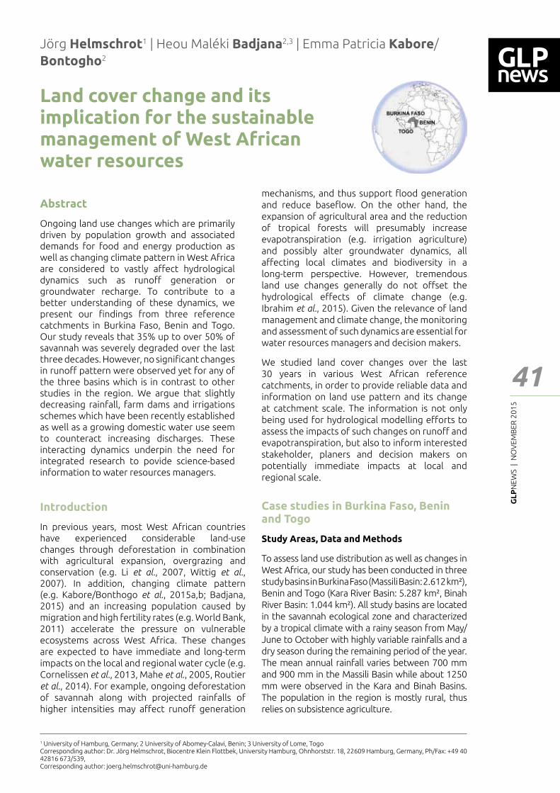
GL
PN
EWS
| N
OV
EMB
ER 2
01
5
41
Feat
ure
- Art
icle
Land cover change and its implication for the sustainable management of West African water resources
Jörg Helmschrot1 | Heou Maléki Badjana2,3 | Emma Patricia Kabore/Bontogho2
Abstract
Ongoing land use changes which are primarily driven by population growth and associated demands for food and energy production as well as changing climate pattern in West Africa are considered to vastly a━ect hydrological dynamics such as runo━ generation or groundwater recharge. To contribute to a better understanding of these dynamics, we present our ┃ndings from three reference catchments in Burkina Faso, Benin and Togo. Our study reveals that 35% up to over 50% of savannah was severely degraded over the last three decades. However, no signi┃cant changes in runo━ pattern were observed yet for any of the three basins which is in contrast to other studies in the region. We argue that slightly decreasing rainfall, farm dams and irrigations schemes which have been recently established as well as a growing domestic water use seem to counteract increasing discharges. These interacting dynamics underpin the need for integrated research to povide science-based information to water resources managers.
mechanisms, and thus support ┅ood generation and reduce base┅ow. On the other hand, the expansion of agricultural area and the reduction of tropical forests will presumably increase evapotranspiration (e.g. irrigation agriculture) and possibly alter groundwater dynamics, all a━ecting local climates and biodiversity in a long-term perspective. However, tremendous land use changes generally do not o━set the hydrological e━ects of climate change (e.g. Ibrahim et al., 2015). Given the relevance of land management and climate change, the monitoring and assessment of such dynamics are essential for water resources managers and decision makers.
We studied land cover changes over the last 30 years in various West African reference catchments, in order to provide reliable data and information on land use pattern and its change at catchment scale. The information is not only being used for hydrological modelling e━orts to assess the impacts of such changes on runo━ and evapotranspiration, but also to inform interested stakeholder, planers and decision makers on potentially immediate impacts at local and regional scale.
Case studies in Burkina Faso, Benin and Togo
Study Areas, Data and Methods
To assess land use distribution as well as changes in West Africa, our study has been conducted in three study basins in Burkina Faso (Massili Basin: 2.612 km²), Benin and Togo (Kara River Basin: 5.287 km², Binah River Basin: 1.044 km²). All study basins are located in the savannah ecological zone and characterized by a tropical climate with a rainy season from May/June to October with highly variable rainfalls and a dry season during the remaining period of the year. The mean annual rainfall varies between 700 mm and 900 mm in the Massili Basin while about 1250 mm were observed in the Kara and Binah Basins. The population in the region is mostly rural, thus relies on subsistence agriculture.
1 University of Hamburg, Germany; 2 University of Abomey-Calavi, Benin; 3 University of Lome, TogoCorresponding author: Dr. Jörg Helmschrot, Biocentre Klein Flottbek, University Hamburg, Ohnhorststr. 18, 22609 Hamburg, Germany, Ph/Fax: +49 40 42816 673/539, Corresponding author: [email protected]
Introduction
In previous years, most West African countries have experienced considerable land-use changes through deforestation in combination with agricultural expansion, overgrazing and conservation (e.g. Li et al., 2007, Wittig et al., 2007). In addition, changing climate pattern (e.g. Kabore/Bonthogo et al., 2015a,b; Badjana, 2015) and an increasing population caused by migration and high fertility rates (e.g. World Bank, 2011) accelerate the pressure on vulnerable ecosystems across West Africa. These changes are expected to have immediate and long-term impacts on the local and regional water cycle (e.g. Cornelissen et al., 2013, Mahe et al., 2005, Routier et al., 2014). For example, ongoing deforestation of savannah along with projected rainfalls of higher intensities may a━ect runo━ generation
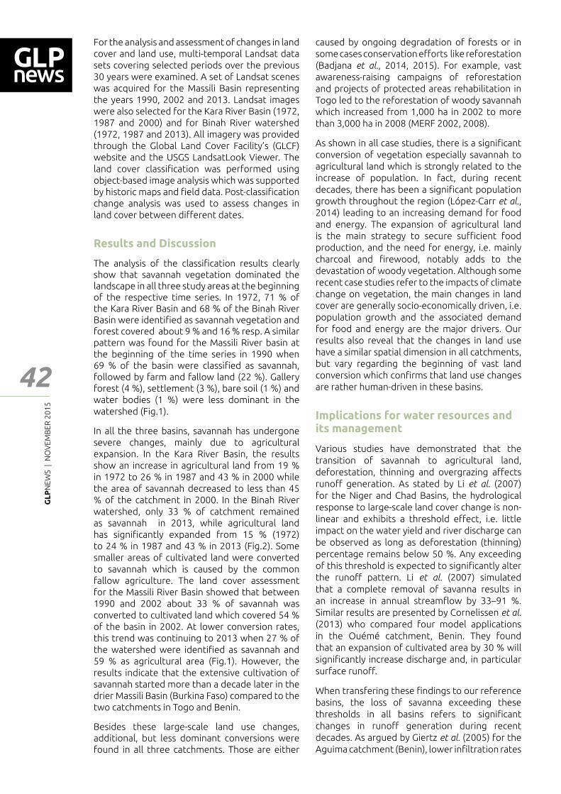
GL
PN
EWS
| N
OV
EMB
ER 2
01
5
42
For the analysis and assessment of changes in land cover and land use, multi-temporal Landsat data sets covering selected periods over the previous 30 years were examined. A set of Landsat scenes was acquired for the Massili Basin representing the years 1990, 2002 and 2013. Landsat images were also selected for the Kara River Basin (1972, 1987 and 2000) and for Binah River watershed (1972, 1987 and 2013). All imagery was provided through the Global Land Cover Facility�s (GLCF) website and the USGS LandsatLook Viewer. The land cover classi┃cation was performed using object-based image analysis which was supported by historic maps and ┃eld data. Post-classi┃cation change analysis was used to assess changes in land cover between di━erent dates.
Results and Discussion
The analysis of the classi┃cation results clearly show that savannah vegetation dominated the landscape in all three study areas at the beginning of the respective time series. In 1972, 71 % of the Kara River Basin and 68 % of the Binah River Basin were identi┃ed as savannah vegetation and forest covered about 9 % and 16 % resp. A similar pattern was found for the Massili River basin at the beginning of the time series in 1990 when 69 % of the basin were classi┃ed as savannah, followed by farm and fallow land (22 %). Gallery forest (4 %), settlement (3 %), bare soil (1 %) and water bodies (1 %) were less dominant in the watershed (Fig.1).
In all the three basins, savannah has undergone severe changes, mainly due to agricultural expansion. In the Kara River Basin, the results show an increase in agricultural land from 19 % in 1972 to 26 % in 1987 and 43 % in 2000 while the area of savannah decreased to less than 45 % of the catchment in 2000. In the Binah River watershed, only 33 % of catchment remained as savannah in 2013, while agricultural land has signi┃cantly expanded from 15 % (1972) to 24 % in 1987 and 43 % in 2013 (Fig.2). Some smaller areas of cultivated land were converted to savannah which is caused by the common fallow agriculture. The land cover assessment for the Massili River Basin showed that between 1990 and 2002 about 33 % of savannah was converted to cultivated land which covered 54 % of the basin in 2002. At lower conversion rates, this trend was continuing to 2013 when 27 % of the watershed were identi┃ed as savannah and 59 % as agricultural area (Fig.1). However, the results indicate that the extensive cultivation of savannah started more than a decade later in the drier Massili Basin (Burkina Faso) compared to the two catchments in Togo and Benin.
Besides these large-scale land use changes, additional, but less dominant conversions were found in all three catchments. Those are either
caused by ongoing degradation of forests or in some cases conservation e━orts like reforestation (Badjana et al., 2014, 2015). For example, vast awareness-raising campaigns of reforestation and projects of protected areas rehabilitation in Togo led to the reforestation of woody savannah which increased from 1,000 ha in 2002 to more than 3,000 ha in 2008 (MERF 2002, 2008).
As shown in all case studies, there is a signi┃cant conversion of vegetation especially savannah to agricultural land which is strongly related to the increase of population. In fact, during recent decades, there has been a signi┃cant population growth throughout the region (López-Carr et al., 2014) leading to an increasing demand for food and energy. The expansion of agricultural land is the main strategy to secure su┆cient food production, and the need for energy, i.e. mainly charcoal and ┃rewood, notably adds to the devastation of woody vegetation. Although some recent case studies refer to the impacts of climate change on vegetation, the main changes in land cover are generally socio-economically driven, i.e. population growth and the associated demand for food and energy are the major drivers. Our results also reveal that the changes in land use have a similar spatial dimension in all catchments, but vary regarding the beginning of vast land conversion which con┃rms that land use changes are rather human-driven in these basins.
Implications for water resources and its management
Various studies have demonstrated that the transition of savannah to agricultural land, deforestation, thinning and overgrazing a━ects runo━ generation. As stated by Li et al. (2007) for the Niger and Chad Basins, the hydrological response to large-scale land cover change is non-linear and exhibits a threshold e━ect, i.e. little impact on the water yield and river discharge can be observed as long as deforestation (thinning) percentage remains below 50 %. Any exceeding of this threshold is expected to signi┃cantly alter the runo━ pattern. Li et al. (2007) simulated that a complete removal of savanna results in an increase in annual stream┅ow by 33–91 %. Similar results are presented by Cornelissen et al. (2013) who compared four model applications in the Ouémé catchment, Benin. They found that an expansion of cultivated area by 30 % will signi┃cantly increase discharge and, in particular surface runo━.
When transfering these ┃ndings to our reference basins, the loss of savanna exceeding these thresholds in all basins refers to signi┃cant changes in runo━ generation during recent decades. As argued by Giertz et al. (2005) for the Aguima catchment (Benin), lower in┃ltration rates
Feat
ure
- Art
icle
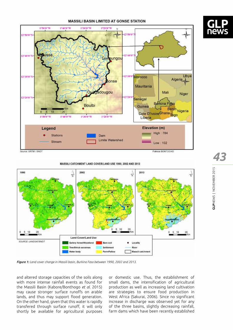
GL
PN
EWS
| N
OV
EMB
ER 2
01
5
43
Feat
ure
- Art
icle
Figure 1: Land cover change in Massili basin, Burkina Faso between 1990, 2002 and 2013.
and altered storage capacities of the soils along with more intense rainfall events as found for the Massili Basin (Kabore/Bonthogo et al. 2015) may cause stronger surface runo━s on arable lands, and thus may support ┅ood generation. On the other hand, given that this water is rapidly transfered through surface runo━, it will only shortly be available for agricultural purposes
or domestic use. Thus, the establishment of small dams, the intensi┃cation of agricultural production as well as increasing land cultivation are strategies to ensure food production in West Africa (Sakurai, 2006). Since no signi┃cant increase in discharge was observed yet for any of the three basins, slightly decreasing rainfall, farm dams which have been recently established
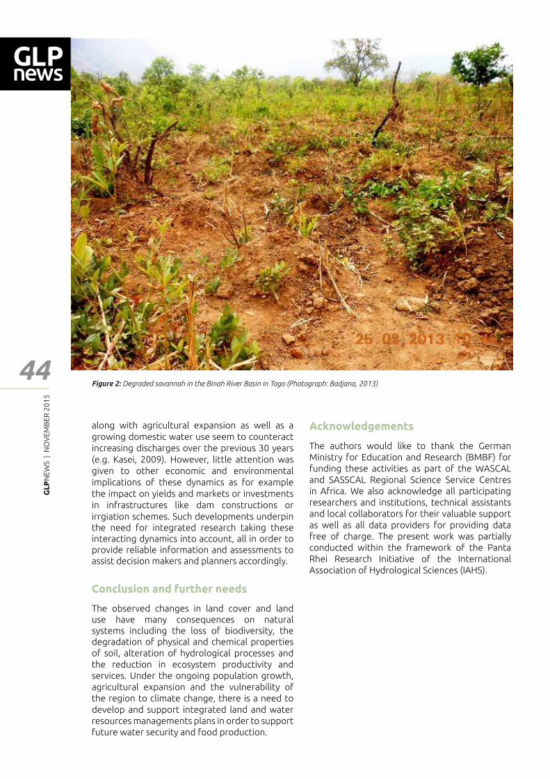
GL
PN
EWS
| N
OV
EMB
ER 2
01
5
44
along with agricultural expansion as well as a growing domestic water use seem to counteract increasing discharges over the previous 30 years (e.g. Kasei, 2009). However, little attention was given to other economic and environmental implications of these dynamics as for example the impact on yields and markets or investments in infrastructures like dam constructions or irrgiation schemes. Such developments underpin the need for integrated research taking these interacting dynamics into account, all in order to provide reliable information and assessments to assist decision makers and planners accordingly.
Conclusion and further needs
The observed changes in land cover and land use have many consequences on natural systems including the loss of biodiversity, the degradation of physical and chemical properties of soil, alteration of hydrological processes and the reduction in ecosystem productivity and services. Under the ongoing population growth, agricultural expansion and the vulnerability of the region to climate change, there is a need to develop and support integrated land and water resources managements plans in order to support future water security and food production.
Acknowledgements
The authors would like to thank the German Ministry for Education and Research (BMBF) for funding these activities as part of the WASCAL and SASSCAL Regional Science Service Centres in Africa. We also acknowledge all participating researchers and institutions, technical assistants and local collaborators for their valuable support as well as all data providers for providing data free of charge. The present work was partially conducted within the framework of the Panta Rhei Research Initiative of the International Association of Hydrological Sciences (IAHS).
Feat
ure
- Art
icle
Figure 2: Degraded savannah in the Binah River Basin in Togo (Photograph: Badjana, 2013)

GL
PN
EWS
| N
OV
EMB
ER 2
01
5
45
References
Badjana, H.M. (2015): River basin assessment and hydrologic processes modeling for integrated land and water resources management (ILWRM) in West Africa. PhD-Thesis at University of Abomey-Calavi, Benin.
Badjana, H.M.; Wala, K.; Selsam, P.; Flügel, W.-A.; Afouda, A.; Urban, M.; Fink, M.; Helmschrot, J. (2014): Assessment of land-cover dynamics in a sub-catchment of Oti basin (West Africa): A case study of Kara river basin. Zentralblatt für Geologie und Paläontologie; Teil I, 2014, Heft 1:151-170. doi: 10.1127/zgpI/2014/0151-0170.
Badjana, H. M., Helmschrot, J.; Selsam, P.;Wala, K.; Flügel, W.-A.; Afouda, A.; Akpagana, K. (2015): Land cover changes assessment using object-based image analysis in the Binah River watershed (Togo and Benin). Earth and Space Science 2. doi:10.1002/2014EA000083.
Cornelissen, Th.; Diekkrüger, B.; Giertz, S. (2013): A comparison of hydrological models for assessing the impact of land use and climate change on discharge in a tropical catchment. Journal of Hydrology, 498: 221-236. doi:10.1016/j.jhydrol.2013.06.016.
Giertz, S.; Junge, B.; Diekkrüger, B. (2005): Assessing the e━ects of land use change on soil physical properties and hydrological processes in the sub-humid tropical environment of West Africa. Physics and Chemistry of the Earth 30 (8�10): 485�496.
Ibrahim, B.; Karambiri, H.; Polcher, J. (2015): Hydrological Impacts of the Changes in Simulated Rainfall Fields on Nakanbe Basin in Burkina Faso. Climate 3, 442-458; doi:10.3390/cli3030442.
Kabore/Bontogho, P.E.; Ibrahim, B.; Barry, B.; Helmschrot, J. (2015a): Intra-seasonal variability of climate change and peasant perception in central Burkina Faso. International Journal of Current Engineering and Technology (IJCET) 5 (3): 1955-1965.
Kabore/Bontogho, P. E.; Nikiema, M.; Ibrahim, B.; Helmschrot, J. (2015b): Merging historical data records with MPI-ESM-LR, CanESM2, AFR MPI and AFR 44 scenarios to assess long-term climate trends for the Massili Basin in central Burkina Faso. International Journal of Current Engineering and Technology (IJCET) 5 (3): 1846-1852.
Kasei R. A. (2009): Modelling impacts of climate change on water resources in the Volta Basin, West Africa. PhD-Dissertation at Rheinische Friedrich-Wilhelms-Universität Bonn, Germany.
Li, K.Y.; Coe, M.T.; Ramankutty, N.; De Jong, R. (2007): Modeling the hydrological impact of land-use change in West Africa. Journal of Hydrology 337: 258�268. doi:10.1016/j.jhydrol.2007.01.038.
López-Carr, D.; Narcisa, G.P.; Juliann, E.A.; Jankowska, M.M.; Funk,, C.; Husak, G.; Michaelsen, J. (2014): A spatial analysis of population dynamics and climate change in Africa: potential vulnerability hot spots emerge where precipitation declines and demographic pressures coincide. Population Environment 35: 323�339.
Mahe, G.; Paturel, J.-E.; Servat, E.; Conway, D.;Dezetter, A. (2005): The impact of land use change on soil water holding capacity and river ┅ow modelling in the Nakambe River, Burkina-Faso, Journal of Hydrology 300, 33–43, doi: 10.1016/j.jhydrol.2004.04.028.
Roudier, P.; Ducharne, A.; Feyen, L. (2014) Climate change impacts on runo━ in West Africa: a review. Hydrology and Earth System Sciences 18: 2789�2801. doi: 10.5194/hess-18-2789-2014
Ministère de l�Environnement et des Ressources Forestières du Togo (MERF) (2002): Programme d�Action National de Lutte contre la Déserti┃cation (PAN-TOGO).
Ministère de l�Environnement et des Ressources Forestières du Togo (MERF) (2008): Etude sur les Circonstances Nationales, Deuxieme Communication Nationale sur les Changements Climatiques, projet numéro 00053108.
Sakurai, Z. (2006): Intensi┃cation of rainfed lowland rice production in West Africa: present status and potential green revolution. The Developing Economies, 44: 232�251. doi: 10.1111/j.1746-1049.2006.00015.x.
Wittig, R.; König, K.; Schmidt, M.; Szarzynski, J. (2007): A Study of Climate Change and Anthro-pogenic Impacts in West Africa. Environmental Science and Pollution Research 14 (3): 182�189, doi: http://dx.doi.org/10.1065/espr2007.02.388
World Bank (2011): Africa development indicators. The World Bank, Washington, DC.
Feat
ure
- Art
icle
GL
PN
EWS
| N
OV
EMB
ER 2
01
5
46
How sustainable is the land footprint of nations? A Planetary Boundary perspective applied to Switzerland
Hy Dao1 | Damien Friot2
1 University of Geneva & UNEP/GRID-Geneva; Université de Genève - Uni Carl Vogt Boulevard Carl Vogt, 66 - 1211 Genève 4 - SWITZERLAND2 Shaping Environmental Action (SEA)
Corresponding author: [email protected]
Global change and sustainable development
Growing demand for natural resources and releases into the environment have generated signi┃cant negative global impacts: climate change, soil degradation, ecosystems decline and degradation, biodiversity loss, air and water pollution, to mention some of the main current environmental issues (UNEP, 2012). It has now become clear at both national and international levels that natural capital consumption and pollutions of the ecosystems must be lowered to naturally sustainable levels for current and future generations. The on-going negotiations on the Sustainable Development Goals at the United Nations re┅ect the increasing consideration of environmental dimensions in global policy targets for human development.
This paper presents an approach based on the concept of Planetary Boundaries, which allows identifying limits for global Earth system, translating them at the national level and assessing environmental performances of countries. It will focus on the speci┃c Planetary Boundary related to land cover and on its application to the case of Switzerland. It is based on the results of a study commissioned by the Swiss Federal O┆ce for the Environment (Dao et al., 2015).
The Planetary Boundaries perspective on land cover
The Planetary Boundaries concept (Rockström et al., 2009; Ste━en et al., 2015) provides a natural science based approach for the de┃nition of sustainable levels of environmental impacts. Unlike the Ecological Footprint, which converts various resources consumptions and pollutions into one single normalized measure of land area, the Planetary Boundaries are a set of nine distinct bio-physical limits of the Earth system that should be respected in order to maintain conditions favourable to human development. Crossing the suggested limits would lead to a
drastic change in human societies by disrupting some of the ecological bases of the current socio-economic system.
The most known Planetary Boundary is Climate Change but other global limits have been identi┃ed: Ocean Acidi┃cation, Stratospheric Ozone Depletion, Nitrogen and Phosphorus Losses, Atmospheric Aerosol Loading, Freshwater Use, Land Cover Anthropisation, Biodiversity Loss and Chemical Pollution (note : these names are the one used in Dao et al. (2015), they di━er slightly from Rockström et al. (2009) and Ste━en et al. (2015).
To measure the actual environmental impacts of countries, footprints - also known as consumption-based or demand-based indicators � are a necessary complementary perspective to the classical territorial indicators. In our interlinked global economy (Friot, 2009) a rising part of the impacts on a territory is in fact generated to satisfy consumers in other countries. Territorial indicators consider impacts occurring on the territory of a country, e.g. the forest cover changes as reported in FAO statistics. Footprints aggregate impacts along global production-consumption chains according to a life cycle perspective. They allow quantifying the environmental impacts induced by the consumption of the inhabitants of a country wherever these impacts occur on Earth, e. g. the forest areas cleared in the tropics for the production of palm oil consumed in Western countries.
Tukker et al. (2014) show in the �Global Resource Footprint of Nations” that the EU has a signi┃cant share of its carbon, water and land footprints on the rest of the world. A study by Jungbluth et al. (2011) showed that more than half of the environmental impacts caused by Swiss consumption occur abroad, a share rising from 1996 to 2011 (Frischknecht et al., 2014). Other countries like Brazil or China are, on the contrary, providing their resource base to other countries (Tukker et al., 2014).
Feat
ure
- Art
icle
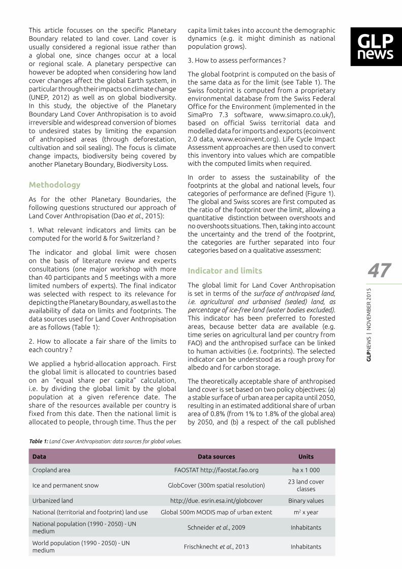
GL
PN
EWS
| N
OV
EMB
ER 2
01
5
47
Feat
ure
- Art
icle
This article focusses on the speci┃c Planetary Boundary related to land cover. Land cover is usually considered a regional issue rather than a global one, since changes occur at a local or regional scale. A planetary perspective can however be adopted when considering how land cover changes a━ect the global Earth system, in particular through their impacts on climate change (UNEP, 2012) as well as on global biodiversity. In this study, the objective of the Planetary Boundary Land Cover Anthropisation is to avoid irreversible and widespread conversion of biomes to undesired states by limiting the expansion of anthropised areas (through deforestation, cultivation and soil sealing). The focus is climate change impacts, biodiversity being covered by another Planetary Boundary, Biodiversity Loss.
Methodology
As for the other Planetary Boundaries, the following questions structured our approach of Land Cover Anthropisation (Dao et al., 2015):
1. What relevant indicators and limits can be computed for the world & for Switzerland ?
The indicator and global limit were chosen on the basis of literature review and experts consultations (one major workshop with more than 40 participants and 5 meetings with a more limited numbers of experts). The ┃nal indicator was selected with respect to its relevance for depicting the Planetary Boundary, as well as to the availability of data on limits and footprints. The data sources used for Land Cover Anthropisation are as follows (Table 1):
2. How to allocate a fair share of the limits to each country ?
We applied a hybrid-allocation approach. First the global limit is allocated to countries based on an �equal share per capita� calculation, i.e. by dividing the global limit by the global population at a given reference date. The share of the resources available per country is fixed from this date. Then the national limit is allocated to people, through time. Thus the per
capita limit takes into account the demographic dynamics (e.g. it might diminish as national population grows).
3. How to assess performances ?
The global footprint is computed on the basis of the same data as for the limit (see Table 1). The Swiss footprint is computed from a proprietary environmental database from the Swiss Federal O┆ce for the Environment (implemented in the SimaPro 7.3 software, www.simapro.co.uk/), based on o┆cial Swiss territorial data and modelled data for imports and exports (ecoinvent 2.0 data, www.ecoinvent.org). Life Cycle Impact Assessment approaches are then used to convert this inventory into values which are compatible with the computed limits when required.
In order to assess the sustainability of the footprints at the global and national levels, four categories of performance are de┃ned (Figure 1). The global and Swiss scores are ┃rst computed as the ratio of the footprint over the limit, allowing a quantitative distinction between overshoots and no overshoots situations. Then, taking into account the uncertainty and the trend of the footprint, the categories are further separated into four categories based on a qualitative assessment:
Indicator and limits
The global limit for Land Cover Anthropisation is set in terms of the surface of anthropised land,
i.e. agricultural and urbanised (sealed) land, as
percentage of ice-free land (water bodies excluded). This indicator has been preferred to forested areas, because better data are available (e.g. time series on agricultural land per country from FAO) and the anthropised surface can be linked to human activities (i.e. footprints). The selected indicator can be understood as a rough proxy for albedo and for carbon storage.
The theoretically acceptable share of anthropised land cover is set based on two policy objectives: (a) a stable surface of urban area per capita until 2050, resulting in an estimated additional share of urban area of 0.8% (from 1% to 1.8% of the global area) by 2050, and (b) a respect of the call published
Data Data sources Units
Cropland area FAOSTAT http://faostat.fao.org ha x 1 000
Ice and permanent snow GlobCover (300m spatial resolution)23 land cover
classes
Urbanized land http://due. esrin.esa.int/globcover Binary values
National (territorial and footprint) land use Global 500m MODIS map of urban extent m2 x year
National population (1990 - 2050) - UN medium
Schneider et al., 2009 Inhabitants
World population (1990 - 2050) - UN medium
Frischknecht et al., 2013 Inhabitants
Table 1: Land Cover Anthropisation: data sources for global values.
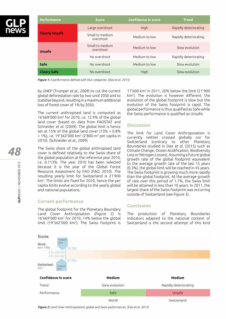
GL
PN
EWS
| N
OV
EMB
ER 2
01
5
48
Feat
ure
- Art
icle
Performance Score Con┃dence in score Trend
Clearly Unsafe
Large overshoot High Rapidly deteriorating
Small to medium overshoot
Medium to low Rapidly deteriorating
Unsafe
Small to medium overshoot
Medium to low Slow evolution
No overshoot Medium to low Rapidly deteriorating
Safe No overshoot Medium to low Slow evolution
Cleary Safe No overshoot High Slow evolution
Figure 1: A performance de┃ned with four categories. (Dao et.al. 2015)
Figure 2: Land Cover Anthropisation: global and Swiss performances. (Dao et.al. 2015)
by UNEP (Trumper et al., 2009) to cut the current global deforestation rate by two until 2050 and to stabilise beyond, resulting in a maximum additional loss of forest cover of 1% by 2050.
The current anthropised land is computed as 16�669�000 km2 for 2010, i.e. 12.9% of the global land cover (based on data from FAOSTAT and Schneider et al. (2009). The global limit is hence set at 15% of the global land cover (13% + 0.8% + 1%), i.e. 19�362�000 km2 (2�800 m2 per capita in 2010). (Schneider et al., 2009)
The Swiss share of the global anthropised land cover is de┃ned relatively to the Swiss share of the global population at the reference year 2010, i.e. 0.113%. The year 2010 has been selected because it is the year of the Global Forest Resource Assessment by FAO (FAO, 2010). The resulting yearly limit for Switzerland is 21�900 km2. The limits are ┃xed for 2010, hence the per capita limits evolve according to the yearly global and national populations.
Current performance
The global footprint for the Planetary Boundary Land Cover Anthropisation (Figure 2) is 16�669�000 km2 for 2010, 14% below the global limit (19�362�000 km2). The Swiss footprint is
17�600 km2 in 2011, 20% below the limit (21�900 km2). The evolution is however di━erent: the evolution of the global footprint is slow but the evolution of the Swiss footprint is rapid. The global performance is thus quali┃ed as Safe while the Swiss performance is quali┃ed as Unsafe.
Discussion
The limit for Land Cover Anthroposation is currently neither crossed globally nor for Switzerland (contrary to other Planetary Boundaries studied in Dao et al. (2015) such as Climate Change, Ocean Acidi┃cation, Biodiversity Loss or Nitrogen Losses). Assuming a future global growth rate of the global footprint equivalent to the average growth rate of the last 15 years (0.3%), the global limit will be reached in 45 years. The Swiss footprint is growing much more rapidly than the global footprint. At the average growth of rate over this period of 1.7%, the Swiss limit will be attained in less than 10 years. In 2011, the largest share of the Swiss footprint was occurring outside of Switzerland (see Figure 3).
Conclusion
The production of Planetary Boundaries indicators adapted to the national context of Switzerland is the second attempt of this kind
Con┃dence in score Medium Medium
Trend Slow evolution Rapidly deteriorating
Performance Safe Unsafe
World Switzerland
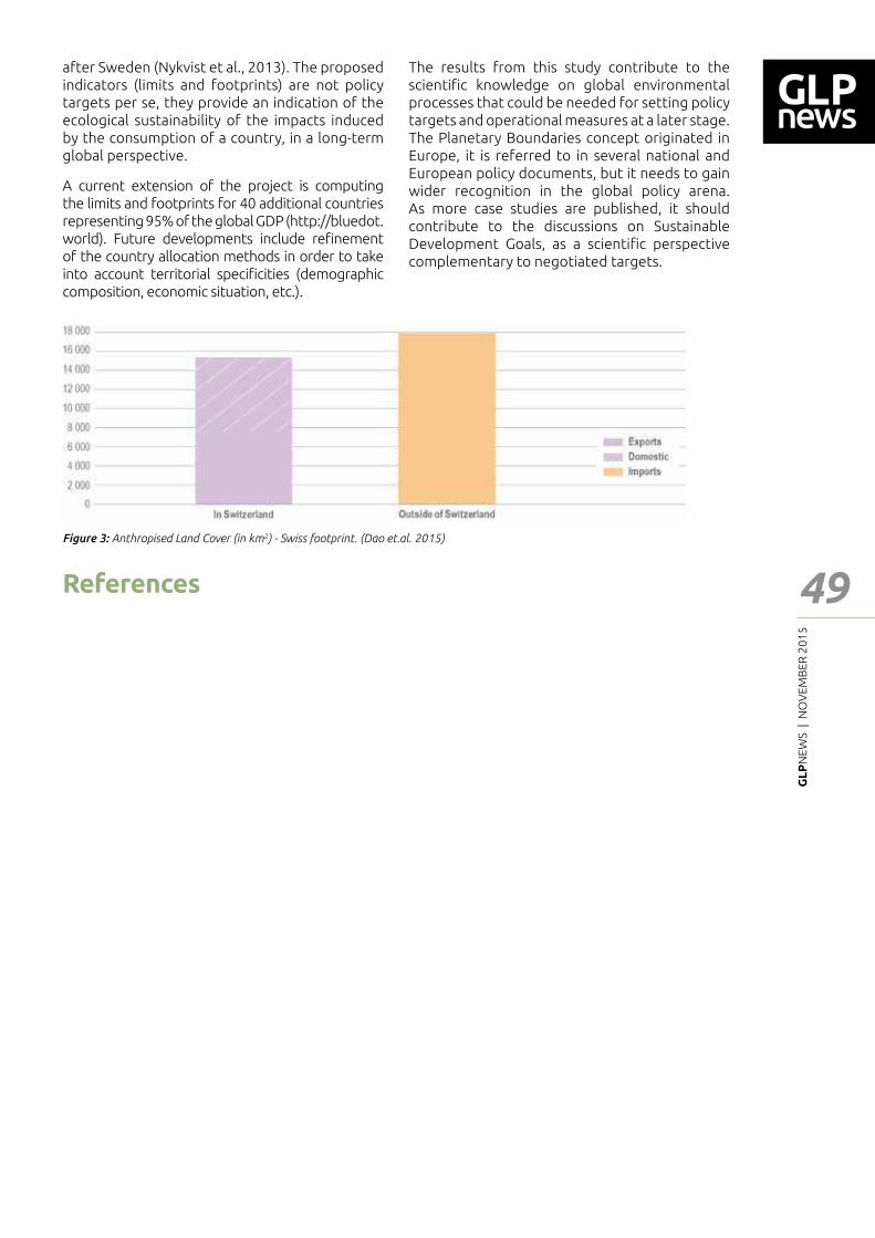
GL
PN
EWS
| N
OV
EMB
ER 2
01
5
49
Feat
ure
- Art
icle
Figure 3: Anthropised Land Cover (in km2) - Swiss footprint. (Dao et.al. 2015)
after Sweden (Nykvist et al., 2013). The proposed indicators (limits and footprints) are not policy targets per se, they provide an indication of the ecological sustainability of the impacts induced by the consumption of a country, in a long-term global perspective.
A current extension of the project is computing the limits and footprints for 40 additional countries representing 95% of the global GDP (http://bluedot.world). Future developments include re┃nement of the country allocation methods in order to take into account territorial speci┃cities (demographic composition, economic situation, etc.).
The results from this study contribute to the scienti┃c knowledge on global environmental processes that could be needed for setting policy targets and operational measures at a later stage. The Planetary Boundaries concept originated in Europe, it is referred to in several national and European policy documents, but it needs to gain wider recognition in the global policy arena. As more case studies are published, it should contribute to the discussions on Sustainable Development Goals, as a scienti┃c perspective complementary to negotiated targets.
References
Dao Hy, Friot Damien, Peduzzi Pascal, Bruno Chatenoux, Andrea De Bono, Stefan Schwarzer (2015), Environmental limits and Swiss footprints based on Planetary Boundaries, UNEP/GRID-Geneva & University of Geneva, Geneva, Switzerland, http://pb.grid.unep.ch.
FAO (2010) Global Forest Resources Assessment 2010. Rome: Food and Agriculture Organization of the United Nations
Friot D. (2009) Environmental Accounting and globalisation. Which models to tackle new challenges? Applying Economics-Environment-Impacts models to evaluate environmental impacts induced by Europe in China, and EU carbon tarifs [WWW document]. Paris: Ecole Nationale Supérieure des Mines de Paris URL https://pastel.archives-ouvertes.fr/pastel-00527496
Frischknecht R. & Büsser Knöpfel S. (2013) Swiss Eco-Factors 2013 according to the Ecological Scarcity Method. Methodological fundamentals and their application in Switzerland [WWW document]. Bern: Federal O┆ce for the Environment URL http://www.bafu.admin.ch/publikationen/publikation/01750/index.html?lang=en
Frischknecht R., Nathani C., Büsser Knöpfel S., Itten R., Wyss F. & Hellmüller P. (2014) Development of Switzerland�s worldwide environmental impact [WWW document]. Bern: Federal O┆ce for the Environment FOEN URL http://www.bafu.admin.ch/publikationen/publikation/01771/index.html?lang=en
Jungbluth N., Stucki M. & Leuenberger M. (2011) Environmental Impacts of Swiss Consumption and Production. A combination of input-outpout analysis with life cycle assessment. Bern, Switzerland: Federal O┆ce for the Environment FOEN
Nykvist B., Persson Å., Moberg F., Persson L., Cornell S. & Rockström J. (2013) National Environmental Performance on Planetary Boundaries. A study for the Swedish Environmental Protection Agency [WWW document]. URL http://www.naturvardsverket.se/Om-Naturvardsverket/Publikationer/ISBN/6500/978-91-620-6576-8/
Rockström J., Ste━en W., Noone K., Persson Å., Chapin F. S., Lambin E. F., Lenton T. M., Sche━er M., Folke C., Schellnhuber H. J., Nykvist B., de Wit C. A., Hughes T., van der Leeuw S., Rodhe H., Sörlin S., Snyder P. K., Costanza R., Svedin U., Falkenmark M., et al. (2009b) A safe operating space for humanity. Nature 461: 472�475
Schneider A., Friedl M. A. & Potere D. (2009) A new map of global urban extent from MODIS satellite data. Environmental Research Letters 4: 044003
Ste━en W., Richardson K., Rockström J., Cornell S. E., Fetzer I., Bennett E. M., Biggs R., Carpenter S. R., Vries W. de, Wit C. A. de, Folke C., Gerten D., Heinke J., Mace G. M., Persson L. M., Ramanathan V., Reyers B. & Sörlin S. (2015) Planetary boundaries: Guiding human development on a changing planet. Science 347: 1259855
Trumper K., Bertzky M., Dickson B., van der Heijden G., Jenkins M. & Manning P. (2009) The Natural Fix? The role of ecosystems in climate mitigation. A UNEP rapid response assessment. [WWW document]. Cambridge, UK: United Nations Environment Programme, UNEP-WCMC URL http://www.unep.org/pdf/BioseqRRA_scr.pdf
Tukker A., Bulavskaya T., Giljum S., de Koning A., Lutter S., Simas M., Stadler K. & Wood R. (2014) The Global Resource Footprint of Nations. Carbon, water, land and materials embodied in trade and ┃nal consumption calculated with EXIOBASE 2.1. Leiden/Delft/Vienna/Trondheim: Organisation for Applied Scienti┃c Research / Vienna University of Economics and Business / Norwegian University of Science and Technology
UNEP (2012) Global Environment Outlook 5 (GEO-5) [WWW document]. Nairobi, Kenya: UNEP URL http://www.unep.org/geo/
GL
PN
EWS
| N
OV
EMB
ER 2
01
5
50
Feat
ure
- Art
icle
Researching into Bio-Energy Change and Sustainable Land Use in the New Millennium
1 Population Education Resource Centre (PERC), Department of Continuing and Adult Education and Extension Work, S. N. D. T. Women�s University, 1, Nathibai Thackerey Road, Mumbai - 400020, Maharashtra, India.Corresponding author: [email protected]
Santosh Kumar Mishra1
Abstract
It is estimated that the human footprint has a━ected 83% of the global terrestrial land surface. Land use and land cover (LUCC) change has been the most visible indicator of the human footprint and the most important driver of loss of biodiversity and other forms of land degradation. Recent trends on global demand for food and bio-energy change (which are closely linked to food and energy price spikes and volatility) have raised concerns on the impact of LUCC change on biodiversity and other environmental impacts. This paper aims to assess the LUCC change. Also, it explores factors which could be addressed to ensure sustainable development in the context of land use planning and management. In terms of methodology employed, secondary data (which are largely qualitative in nature) have been analyzed in a descriptive manner. The paper concludes that integrated economic, geographic and ecological models are required to capture the multiple drivers of LUCC and objectives of ecosystems.
Introduction
Land use and land cover (LUCC) change has been the most visible indicator of the human footprint and the most important driver of loss of biodiversity and other forms of land degradation (Sanderson E. W. et al, 2002). Recent trends on global demand for food and bio-energy change (which are closely linked to food and energy price spikes and volatility) have raised concerns on the impact of LUCC change on biodiversity and other environmental impacts (Balmford A. et al, 2002). This paper aims to assess the LUCC change and explores factors which could be addressed to ensure sustainable development. In broader terms, it (a) explores what science tells us about LUCC change, and (b) analyzes land management programs and the e━ectiveness of market-based instruments.
Land use and Land Cover (LUCC) Change – Some Re┅ections
Forest trends across the regions of the globe are driven by economic development, government policies and other socio-economic factors. In the past two decades (1990-2010), forest density has increased globally while forest extent has slightly decreased by 0.2% per year in 1990-2000 and by 0.1% in 2000-10 which gives hope for more sustainable land use in the years and decades to come. (Santilli, M. et al., 2003). Overall, forest density and extent has increased in high income countries and generally declined in low income countries. The increased density of forests has been responsible for substantially increasing sequestered carbon in Europe and North America over the past 20 years, according to a recent study. Forested areas in 28 Europe countries and 21 Asian countries grew by over 4% and around 2% respectively. There was, however, little change to the area covered by forests in the North American region. For countries in Europe and North America, there have been signi┃cant increases in the density of forests in addition to slight increases in forest areas (European Comission, 2011).
Nevertheless, a key challenge will also be to ┃ll yield gaps with a global food demand expecting to increase by 70 to 110 percent by 2050. The yield gap (or yield ratio), de┃ned as the ratio of the dividend yield of an equity and the yield of a long-term government bond, is another areas of concern in this context. The yield gap remains wide in SSA (Sub � Sahara Africa) and other developing countries. This requires investment to address constraints which contribute to low agricultural productivity, which include poor market infrastructure and generally low investment in agriculture (Kuhn A., 2003). Furthermore, the choice of land use and decisions to change it are in┅uenced by a combination of many factors, such as:
a) size of the household,
b) age, gender,
GL
PN
EWS
| N
OV
EMB
ER 2
01
5
51
Feat
ure
- Art
icle
c) education,
d) employment,
e) attitudes,
f) values and personal traits of household members,
g) site-speci┃c conditions,
h) transportation cost,
i) pro┃ts,
j) competition,
k) costs of production,
l) product prices,
m) public and private ┃nancial support,
n) land-management practices,
o) land tenure, and
p) land ownership.
Biodiversity
Biodiversity provides a variety of ecosystem services, which, for a long time, have been ignored or undervalued. Greater biodiversity ensures more stable and resilient ecosystems. The Chennai Declaration states that biodiversity must be conserved because it is the raw material for food and health nutrition and provides material for biotechnology industry (Koohafkan P. and M A. Altieri., 2011). Hence changes in the abundance and diversity of species may have serious impacts on human welfare. For example, in many rural communities from developing countries, up to 80% of people rely on wild ┅ora and fauna for health care and wild meats provide 30-80% of their protein (Nasi R., A. Taber and N. van Vliet, 2011). Realizing the rapid loss of biodiversity and its potential impact on ecosystems and consequently human welfare, 193 of the 194 countries in the world are signatories of the CBD (Chomitz K., 2004).
Biodiversity is strongly related to forests, and its protection to the establishment of protected areas. Globally, protected area increased by 38% in 2010 from its level in 1992. Despite the impressive increase in protected area, loss of biodiversity remains quite high since biodiversity is naturally developed over a long time and therefore increase in protected area cannot lead to immediate increase in biodiversity � at least in the short-run (McCarlla A. and C. Revoredo, 2001).
Bio-Energy
The extent of land use changes that are caused by large-scale bio-fuels production has generated a great deal of debate within the energy and environmental policy and research communities. A recent study showed that of the 203.4 million
ha of land acquired globally since 2000, 66% was obtained from Africa and that of the 71 million ha veri┃ed by the study, 40% were acquired for bio-fuel production while only 25% was for production of crops for food, 3% for livestock production and 5% for non-food crops such as cotton (Anseeuw, W. et al, 2012).
Managing Competing Demands for Land – Re┅ection from Brazil, Democratic Republic of Congo (DRC) and Indonesia:
Brazil accounts for 13% of the 2010 global forest extent of 4,033.06 million ha while DRC and Indonesia respectively account for 4% and 2% of the global forest extent (Foster V. and C. B. Briceno-Garmendia, 2010). The Brazilian agricultural sector has been a unique example; its contribution to the GDP has increased from 5% in 2006 to 6.1% in 2010 (World Bank, 2011) while its deforestation rate has fallen dramatically. Brief description of land use in the Brazilian Amazon is presented in Box � 1.
Democratic Republic of Congo (DRC), on the other hand, is home to the largest rainforest in Africa. With 68% of its land area under forest, the country accounts for 34.6% of the region�s carbon stock (Baccini, A. N., et al, 2008). Furthermore, forest is the largest land use type in Indonesia. The extent of forest in Indonesia covers about 53% of land area and Indonesia has the third largest tropical forest. The agricultural sector, which contributes 16% of the GDP (Anderson, K. and S. Nelgen, 2012) covers only 22% of the land area.
Policies at National and International Levels
Policies both at national and global level have a large in┅uence on LUCC. Recent studies have shown that increasing food prices have prompted importing countries to change their trade policies to protect consumers while exporting countries have changed trade policies to the bene┃t of producers. The impact of the price change due to such policies could be felt through the price impact on LUCC and through the direct impact. Minimizing the negative impacts of country-level policies on global or regional community requires a global action through the World Trade Organization and other forms of international cooperation (Yatich, T., A., 2008).
Summing up
Integrated economic, geographic and ecological models are required to capture the multiple drivers of LUCC and objectives of ecosystems. For example, ecological economic models can combine ecology and economic principles to determine land allocation to biodiversity, agriculture, forests and other anthropogenic ecosystems.
GL
PN
EWS
| N
OV
EMB
ER 2
01
5
52
Feat
ure
- Art
icle
Land Use in the Brazilian Amazon
In the past three decades, land use in the Brazilian Amazon has been characterized by the intense exploitation of natural resources which has resulted in a mosaic of human-altered habitats without e━ectively improving quality of life and income distribution for the local population. About 17 percent of the Amazon forest has been converted to other land uses in the past 30 years. Most of this area has been transformed into low-productivity pastures. As stated above, this trend is however being slowed down thanks to better land governance and economic transition.
Source: Food and Agricultural Organization (2008)
Land Tenure and Resource Governance in Democratic Republic of Congo
Poor resource governance has been both the cause and result of con┅ict, instability, and poverty in Congo for more than a century. Improving the governance of the country’s signi┃cant natural resource base is critical to achieving greater prosperity, sustaining it, and ensuring that it bene┃ts the nearly 65 million people living there. But better resource governance is an enormous challenge, demanding vision and leadership from government leaders at all levels.
Source: USAID (2014).
References
Anderson, K. and S. Nelgen. (2012). Trade Barrier Volatility and Agricultural Price Stabilization. World Development 40(1): 36-48.
Anseeuw, W. et al. (2012). Land rights and the rush for land. Findings of the Global Commercial Pressures on Land Research Project. International Land Coalition, Rome
Baccini, A. N. et al. (2008). A First Map of Tropical Africa�s Above-Ground Biomass Derived from Satellite Imagery. Environmental Research Letters 3 (4). doi:10.1088/1748-9326/3/4/045011.
Balmford A. et al. (2002). Economic reasons for conserving wild nature. Science 297:95-953.
Chomitz K. (2004). Transferable Development Rights and Forest Protection: An Exploratory Analysis, International Regional Science 27: 348-373.
European Comission. (2011). Science for Environment Policy. European Commission. Brussels, Belgium.
Food and Agricultural Organization (FAO). (2008). Sustainable development and challenging deforestation in the Brazilian Amazon: the good, the bad and the ugly, accessed on August 17, 2015 from http://www.fao.org/docrep/011/i0440e/i0440e03.htm.
Foster V. and C.B. Briceno-Garmendia. (2010). Africa�s infrastructure: A time for transformation. Agence Francaise de Developpment and World Bank. Paris, Washington.
Koohafkan P. and M A. Altieri. (2011). Globally Important Agricultural Heritage Systems A Legacy for the Future. FAO, Rome.
Kuhn A. (2003). From World Market to Trade Flow Modelling�The Re-Designed WATSIM Model. Final report, Institute of Agricultural Policy, Market Research and Economic Sociology.
McCarlla A. and C. Revoredo. (2001). Prospects for Global Food Security. A Critical Appraisal of Past Projections and Predictions. IFPRI 2020 Discussion Paper No. 35. Washington D. C.
Nasi R., A. Taber, N. van Vliet. (2011). Empty forests, empty stomachs? Bushmeat and livelihoods in the Congo and Amazon basins. International Forestry Reviews 13(3):355-368.
Sanderson E. W. et al. (2002). The human footprint and the last of the wild. BioScience 52(10): 891-904.
Santilli, M. et al. (2003). Tropical Deforestation and the Kyoto Protocol: a new proposal. Paper presented at CoP-9, UNFCCC, December 2003, Milan, Italy.
USAID. (2014). Property Rights and Resource Governance � Democratic Republic of Congo, Accessed on August 17, 2015 from http://usaidlandtenure.net/democratic-republic-of-congo.
World Bank. (2011). World Development Report 2011. Con┅ict, Security, and Development.World Bank, Washington D.C
Yatich, T., A. et al. (2008). Moving Beyond Forestry Laws in Sahelian Countries. World Agroforestry Center Policy Brief. Nairobi, Kenya.
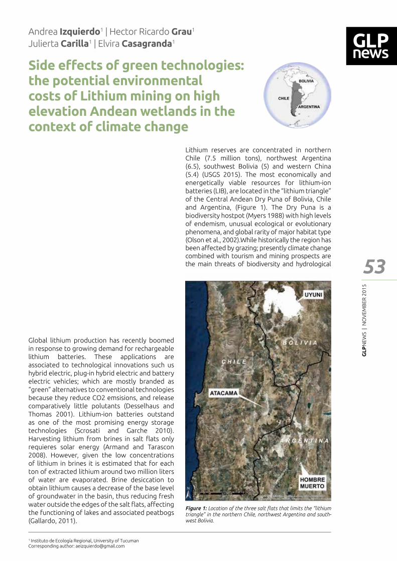
GL
PN
EWS
| N
OV
EMB
ER 2
01
5
53
Feat
ure
- Art
icle
Side e━ects of green technologies: the potential environmental costs of Lithium mining on high elevation Andean wetlands in the context of climate change
Andrea Izquierdo1 | Hector Ricardo Grau1
Julierta Carilla1 | Elvira Casagranda1
Abstract
Lithium-based batteries are the key component of booming green technologies, including hybrid electric, plug-in hybrid electric and battery electric vehicles. Nearly 80% of the global lithium resources are located in the subtropical �Puna� highlands of Argentina, Bolivia and Chile. In these arid ecosystems, most biodiversity is related to wetlands: this highly valuable biodiversity includes the emblematic native camelids, ┅amingos, and a rich variety of endemic plants, and other animals. Climatic trends during the past decades, and future climate models suggest persistent drying tendencies. As other mining operations, lithium exploitations of salty ┅ats require relatively large amounts of water. We discuss the research questions and priorities to preserve these valuable ecosystems in the context of growing potential con┅icts for the use of water.
Global lithium production has recently boomed in response to growing demand for rechargeable lithium batteries. These applications are associated to technological innovations such us hybrid electric, plug-in hybrid electric and battery electric vehicles; which are mostly branded as �green� alternatives to conventional technologies because they reduce CO2 emsisions, and release comparatively little polutants (Desselhaus and Thomas 2001). Lithium-ion batteries outstand as one of the most promising energy storage technologies (Scrosati and Garche 2010). Harvesting lithium from brines in salt ┅ats only requieres solar energy (Armand and Tarascon 2008). However, given the low concentrations of lithium in brines it is estimated that for each ton of extracted lithium around two million liters of water are evaporated. Brine desiccation to obtain lithium causes a decrease of the base level of groundwater in the basin, thus reducing fresh water outside the edges of the salt ┅ats, a━ecting the functioning of lakes and associated peatbogs (Gallardo, 2011).
1 Instituto de Ecología Regional, University of TucumanCorresponding author: [email protected]
Figure 1: Location of the three salt ┅ats that limits the “lithium triangle� in the northern Chile, northwest Argentina and south-west Bolivia.
Lithium reserves are concentrated in northern Chile (7.5 million tons), northwest Argentina (6.5), southwest Bolivia (5) and western China (5.4) (USGS 2015). The most economically and energetically viable resources for lithium-ion batteries (LIB), are located in the �lithium triangle� of the Central Andean Dry Puna of Bolivia, Chile and Argentina, (Figure 1). The Dry Puna is a biodiversity hostpot (Myers 1988) with high levels of endemism, unusual ecological or evolutionary phenomena, and global rarity of major habitat type (Olson et al., 2002).While historically the region has been a━ected by grazing; presently climate change combined with tourism and mining prospects are the main threats of biodiversity and hydrological
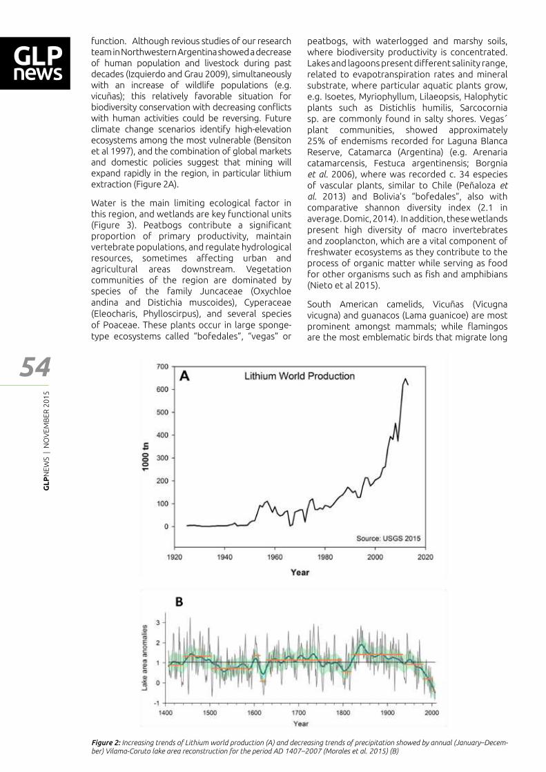
GL
PN
EWS
| N
OV
EMB
ER 2
01
5
54
Feat
ure
- Art
icle
function. Although revious studies of our research team in Northwestern Argentina showed a decrease of human population and livestock during past decades (Izquierdo and Grau 2009), simultaneously with an increase of wildlife populations (e.g. vicuñas); this relatively favorable situation for biodiversity conservation with decreasing con┅icts with human activities could be reversing. Future climate change scenarios identify high-elevation ecosystems among the most vulnerable (Bensiton et al 1997), and the combination of global markets and domestic policies suggest that mining will expand rapidly in the region, in particular lithium extraction (Figure 2A).
Water is the main limiting ecological factor in this region, and wetlands are key functional units (Figure 3). Peatbogs contribute a signi┃cant proportion of primary productivity, maintain vertebrate populations, and regulate hydrological resources, sometimes a━ecting urban and agricultural areas downstream. Vegetation communities of the region are dominated by species of the family Juncaceae (Oxychloe andina and Distichia muscoides), Cyperaceae (Eleocharis, Phylloscirpus), and several species of Poaceae. These plants occur in large sponge-type ecosystems called �bofedales�, �vegas� or
peatbogs, with waterlogged and marshy soils, where biodiversity productivity is concentrated. Lakes and lagoons present di━erent salinity range, related to evapotranspiration rates and mineral substrate, where particular aquatic plants grow, e.g. Isoetes, Myriophyllum, Lilaeopsis, Halophytic plants such as Distichlis humilis, Sarcocornia sp. are commonly found in salty shores. Vegas´ plant communities, showed approximately 25% of endemisms recorded for Laguna Blanca Reserve, Catamarca (Argentina) (e.g. Arenaria catamarcensis, Festuca argentinensis; Borgnia et al. 2006), where was recorded c. 34 especies of vascular plants, similar to Chile (Peñaloza et al. 2013) and Bolivia�s �bofedales�, also with comparative shannon diversity index (2.1 in average. Domic, 2014). In addition, these wetlands present high diversity of macro invertebrates and zooplancton, which are a vital component of freshwater ecosystems as they contribute to the process of organic matter while serving as food for other organisms such as ┃sh and amphibians (Nieto et al 2015).
South American camelids, Vicuñas (Vicugna vicugna) and guanacos (Lama guanicoe) are most prominent amongst mammals; while ┅amingos are the most emblematic birds that migrate long
Figure 2: Increasing trends of Lithium world production (A) and decreasing trends of precipitation showed by annual (January�Decem-ber) Vilama-Coruto lake area reconstruction for the period AD 1407�2007 (Morales et al. 2015) (B)
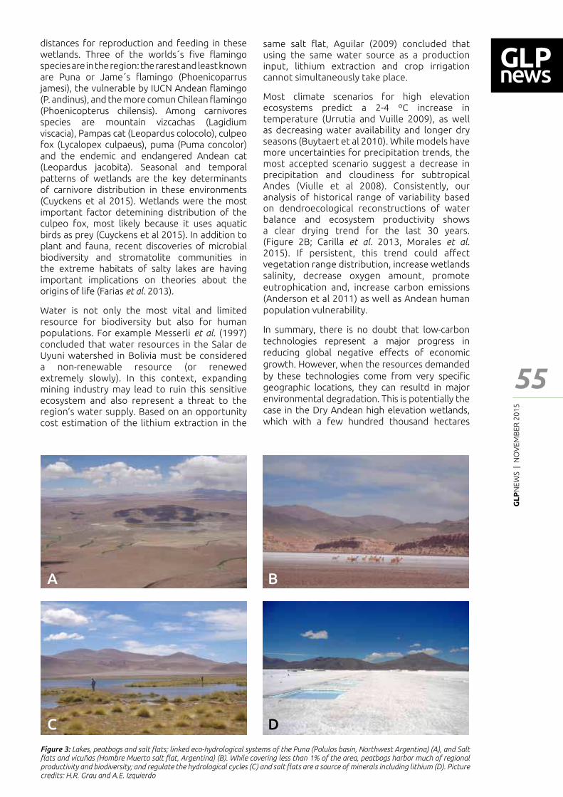
GL
PN
EWS
| N
OV
EMB
ER 2
01
5
55
Feat
ure
- Art
icle
distances for reproduction and feeding in these wetlands. Three of the worlds´s ┃ve ┅amingo species are in the region: the rarest and least known are Puna or Jame´s ┅amingo (Phoenicoparrus jamesi), the vulnerable by IUCN Andean ┅amingo (P. andinus), and the more comun Chilean ┅amingo (Phoenicopterus chilensis). Among carnivores species are mountain vizcachas (Lagidium viscacia), Pampas cat (Leopardus colocolo), culpeo fox (Lycalopex culpaeus), puma (Puma concolor) and the endemic and endangered Andean cat (Leopardus jacobita). Seasonal and temporal patterns of wetlands are the key determinants of carnivore distribution in these environments (Cuyckens et al 2015). Wetlands were the most important factor detemining distribution of the culpeo fox, most likely because it uses aquatic birds as prey (Cuyckens et al 2015). In addition to plant and fauna, recent discoveries of microbial biodiversity and stromatolite communities in the extreme habitats of salty lakes are having important implications on theories about the origins of life (Farias et al. 2013).
Water is not only the most vital and limited resource for biodiversity but also for human populations. For example Messerli et al. (1997) concluded that water resources in the Salar de Uyuni watershed in Bolivia must be considered a non-renewable resource (or renewed extremely slowly). In this context, expanding mining industry may lead to ruin this sensitive ecosystem and also represent a threat to the region�s water supply. Based on an opportunity cost estimation of the lithium extraction in the
same salt ┅at, Aguilar (2009) concluded that using the same water source as a production input, lithium extraction and crop irrigation cannot simultaneously take place.
Most climate scenarios for high elevation ecosystems predict a 2-4 ºC increase in temperature (Urrutia and Vuille 2009), as well as decreasing water availability and longer dry seasons (Buytaert et al 2010). While models have more uncertainties for precipitation trends, the most accepted scenario suggest a decrease in precipitation and cloudiness for subtropical Andes (Viulle et al 2008). Consistently, our analysis of historical range of variability based on dendroecological reconstructions of water balance and ecosystem productivity shows a clear drying trend for the last 30 years. (Figure 2B; Carilla et al. 2013, Morales et al. 2015). If persistent, this trend could a━ect vegetation range distribution, increase wetlands salinity, decrease oxygen amount, promote eutrophication and, increase carbon emissions (Anderson et al 2011) as well as Andean human population vulnerability.
In summary, there is no doubt that low-carbon technologies represent a major progress in reducing global negative e━ects of economic growth. However, when the resources demanded by these technologies come from very speci┃c geographic locations, they can resultd in major environmental degradation. This is potentially the case in the Dry Andean high elevation wetlands, which with a few hundred thousand hectares
A B
C D
Figure 3: Lakes, peatbogs and salt ┅ats; linked eco-hydrological systems of the Puna (Polulos basin, Northwest Argentina) (A), and Salt ┅ats and vicuñas (Hombre Muerto salt ┅at, Argentina) (B). While covering less than 1% of the area, peatbogs harbor much of regional productivity and biodiversity; and regulate the hydrological cycles (C) and salt ┅ats are a source of minerals including lithium (D). Picture credits: H.R. Grau and A.E. Izquierdo

GL
PN
EWS
| N
OV
EMB
ER 2
01
5
56
Feat
ure
- Art
icle
Anderson, E.P., J. Marengo, J. Villalba, S. Halloy, B. Young, D. Cordero, F. Gast, E. Jaimes, D. Ruiz (2011). Consecuencias del cambio climático para ecosistemas y servicios ecosistémicos in los Andes Tropicales. In: Herzog, S.K., Martínez, R., Jorgensen, P. M., Tiessen, H. 2011. Cambio climático y biodiversidad en los Andes Tropicales. Inter-american Institute for Global Change Research (IAI) & Scienti┃c Committee on Problems of the Environment (SCOPE). http://www.iai.int/?p=5922
Aguilar-Fernandez, R. 2009. Estimating the Opportunity Cost of Lithium Extraction in the Salar de Uyuni, Bolivia. Master thesis, Duke University pp58
Armand, M. and J. M. Tarascon. 2008. Bulding better batteries. Nature 451: 652-657
Beniston M, Diaz H, Bradley R. (1997). Climatic change at high elevation sites. An overview. Climatic Change 36, 233-251.
Borgnia, M., A. Maggi, M. Arriaga, B. Aued, B. Vila, M. Cassini. (2006). Caracterización de la vegetación en la Reserva de Biosfera Laguna Blanca (Catamarca, Argentina). Ecología Austral 16: 29-45.
Buytaert, W., C. Tovar Ingar and C.-A. Arnillas. (2010). A regional assessment of climate change impact on water resources in the tropical Andes. BHS Third International Sympsium, Managing Consequences of a Changing Global Environmental, Newcastle.
Carilla, J., H. R. Grau, L. Paolini and M. Morales.(2013). Lake Fluctuations, Plant Productivity, and Long-Term Variability in High-Elevation Tropical Andean Ecosystems. Arctic, Antarctic, and Alpine Research 45(2): 179–189.
Cuyckens, GAE, P. Perovic and L. Cristobal. (2015). How are wetlands and biological interactions related to carnivore distributions at high altitude?. Journal of Arid Environments 115:14-18
Desselhaus, MS and IL Thomas. (2001). Alternative Energies Technologies. Nature 414:332-337
Domic , Alejandra. 2014. Rol de los Bofedales en el Ciclo Hidrológico de la Cuenca del Desaguadero. Informe Final. Herbario de Bolivia, La Paz, Bolivia.
Farías, M. E., N. Rascovan, D. Toneatti, V. Albarracín, R. Flores, O. Ordoñez, D. Poiré, M. M. Collavino, O. M. Aguilar, M. Vazquez and L. Polerecky. (2013). Discovery of Stromatolites Developing under Extreme Conditions in the Andeans Lakes. PLOS ONE 8(1): e53497. doi:10.1371/journal.pone.0053497
Gallardo, Susana. (2011). Extracción de litio en el Norte argentino. La ┃ebre comienza. En Revista EXACTAmente. Revista de divulgación cientí┃ca, FCEN-UBA, Buenos Aires, N°48, pp. 26-29.
Izquierdo, A. E., J. Foguet, H.R. Grau. (2015). Mapping and spatial characterization of Argentine High Andean peatbogs. Wetlands Ecology and Management DOI 10.1007/s11273-015-9433-3
Izquierdo, A. E. and H.R: Grau. (2009). “Agriculture adjustment, ecological transition and protected areas in Northwestern Argentina”. Journal of Environmental Management 90(2).
Olson, D.M.; Dinerstein, E.; Wikramanayake, E.D.; Burgess, N.D.; Powell, G.V.N.; Underwood, E.C.; D’amico, J.A.; Itoua, I.; Strand, H.E.; Morrison, J.C.; Loucks, C.J.; Allnutt, T.F.; Ricketts, T.H.; Kura, Y.; Lamoreux, J.F.; Wettengel, W.W.; Hedao, P.; Kassem, K. Terrestrial. (2001). Ecoregions of the world: A new map of life on earth. BioScience 51:933–938.
Peñaloza APG, V Pardo, A Marticorena, L Cavieres & F Frugone (2013). Flora y Vegetación del Parque Nacional Llullaillaco. 356 páginas.
Messerli, B.; M. Grosjean, M. Vuille. (1997). Water availability, protected areas and natural resources in the Andean desert altiplano. Mountain Research and Development 17:229-238.
Morales, M., J. Carilla, H.R. Grau, R. Villalba. (2015). Multi-century lake area changes in the Andean high – elevation ecosystems of the Southern Altiplano. Clim. Past Discuss, 11:1821-1855.
Myers, N., R. A. Mittermeier, C. G. Mittermeier, G. A. B. da Fonseca, and J. Kent. (2000). Biodiversity hotspots for conservation priorities. Nature 403:835-858.
Nieto, C., A. Malizia, J. Carilla, A. Izquierdo, J. Rodríguez, S. Cuello, M. Zannier and R. Grau. (2015). Patrones espaciales en comunidades de macroinvertebrados acuáticos de la Puna Argentina. Biología Tropical in prenss
Scrosati, B. and J. Garche. (2010). Lithium batteries: Status, prospects and future. Journal of Power Sources 195: 2419-2430.
Urrutia, R. and M. Vuille. (2009). Climate change projections for the tropical Andes using a regional climate model: Temperature and precipitation simulations for the end of the 21st century. Journal of Geophysical Research 114.
U.S. Geological Survey. 2015. Mineral commodity summaries 2015: U.S. Geological Survey, 196 p., http://dx.doi.org/10.3133/70140094. ISBN 978–1–4113–3877–7
Vuille, M., B. Francou, P. Wagnon, I. Juen, G. Kaser, B. G. Mark, R.S. Bradley. 2008. Climate change and tropical Andean glaciers: Past, present and future. Earth-Science Reviews 89, 79–96.
appear bounded to supply the largest part of the global lithium demand. Signi┃cant research e━ort is needed to understand the vulnerability of these ecosystems and their biodiversity to the
combined e━ect of mining expansion and climate change; and these e━ort should be coupled with clear transnational planning guidelines to ensure the sustainable development of the region.
References
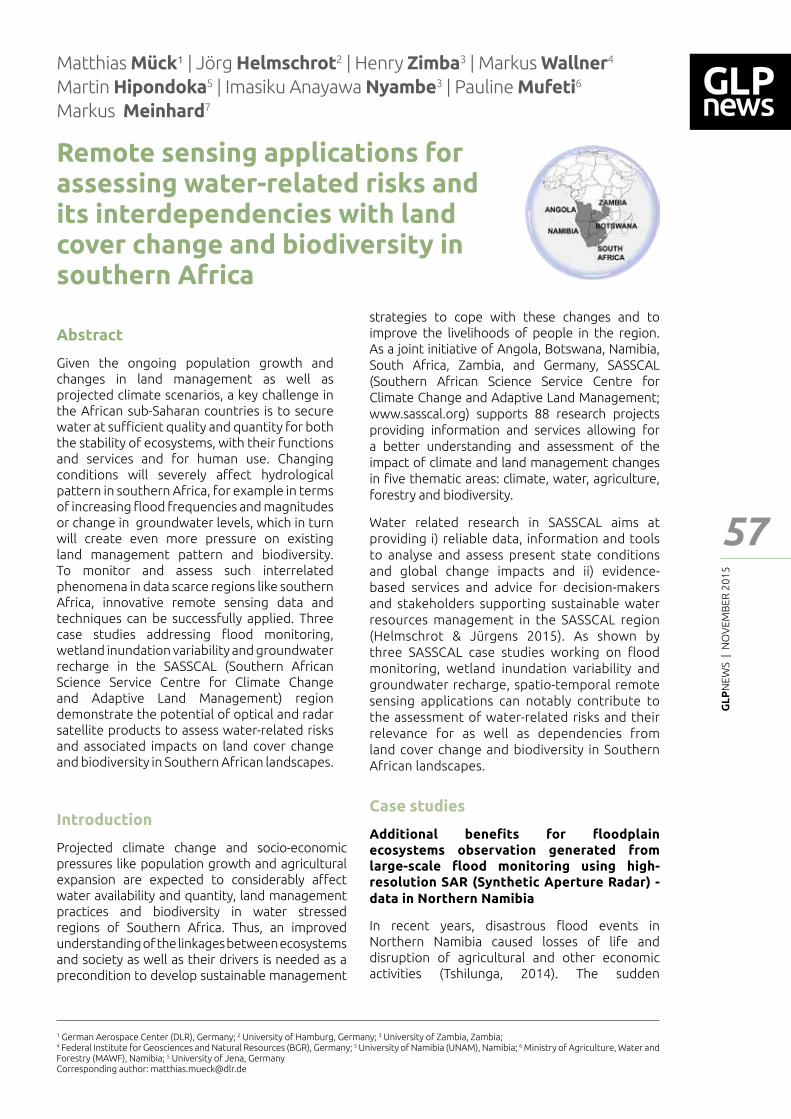
GL
PN
EWS
| N
OV
EMB
ER 2
01
5
57
Feat
ure
- Art
icle
Remote sensing applications for assessing water-related risks and its interdependencies with land cover change and biodiversity in southern Africa
Matthias Mück¹ | Jörg Helmschrot2 | Henry Zimba3 | Markus Wallner4 Martin Hipondoka5 | Imasiku Anayawa Nyambe3 | Pauline Mufeti6 Markus Meinhard7
1 German Aerospace Center (DLR), Germany; 2 University of Hamburg, Germany; 3 University of Zambia, Zambia; 4 Federal Institute for Geosciences and Natural Resources (BGR), Germany; 5 University of Namibia (UNAM), Namibia; 6 Ministry of Agriculture, Water and Forestry (MAWF), Namibia; 5 University of Jena, GermanyCorresponding author: [email protected]
strategies to cope with these changes and to improve the livelihoods of people in the region. As a joint initiative of Angola, Botswana, Namibia, South Africa, Zambia, and Germany, SASSCAL (Southern African Science Service Centre for Climate Change and Adaptive Land Management; www.sasscal.org) supports 88 research projects providing information and services allowing for a better understanding and assessment of the impact of climate and land management changes in ┃ve thematic areas: climate, water, agriculture, forestry and biodiversity.
Water related research in SASSCAL aims at providing i) reliable data, information and tools to analyse and assess present state conditions and global change impacts and ii) evidence-based services and advice for decision-makers and stakeholders supporting sustainable water resources management in the SASSCAL region (Helmschrot & Jürgens 2015). As shown by three SASSCAL case studies working on ┅ood monitoring, wetland inundation variability and groundwater recharge, spatio-temporal remote sensing applications can notably contribute to the assessment of water-related risks and their relevance for as well as dependencies from land cover change and biodiversity in Southern African landscapes.
Case studies
Additional bene┃ts for ┅oodplain ecosystems observation generated from large-scale ┅ood monitoring using high-resolution SAR (Synthetic Aperture Radar) - data in Northern Namibia
In recent years, disastrous ┅ood events in Northern Namibia caused losses of life and disruption of agricultural and other economic activities (Tshilunga, 2014). The sudden
Introduction
Projected climate change and socio-economic pressures like population growth and agricultural expansion are expected to considerably a━ect water availability and quantity, land management practices and biodiversity in water stressed regions of Southern Africa. Thus, an improved understanding of the linkages between ecosystems and society as well as their drivers is needed as a precondition to develop sustainable management
Abstract
Given the ongoing population growth and changes in land management as well as projected climate scenarios, a key challenge in the African sub-Saharan countries is to secure water at su┆cient quality and quantity for both the stability of ecosystems, with their functions and services and for human use. Changing conditions will severely a━ect hydrological pattern in southern Africa, for example in terms of increasing ┅ood frequencies and magnitudes or change in groundwater levels, which in turn will create even more pressure on existing land management pattern and biodiversity. To monitor and assess such interrelated phenomena in data scarce regions like southern Africa, innovative remote sensing data and techniques can be successfully applied. Three case studies addressing ┅ood monitoring, wetland inundation variability and groundwater recharge in the SASSCAL (Southern African Science Service Centre for Climate Change and Adaptive Land Management) region demonstrate the potential of optical and radar satellite products to assess water-related risks and associated impacts on land cover change and biodiversity in Southern African landscapes.
GL
PN
EWS
| N
OV
EMB
ER 2
01
5
58
occurrence and unexpected short ┅ood recurrence intervals were associated with the impacts of climate change and variability. It is therefore expected that the frequency and magnitude of high ┅oods will increase in years to come. Land use and land cover changes due to seasonal ┅ooding, erosion and deposition are normal phenomena in any ┅oodplain. However, increasing river dynamics, modifying ┅oodplains with an undesired frequency and magnitude, can induce severe consequences on the ┅oodplain ecosystems and cultivation, requiring a revision of regional ┅oodplain management programs (Hazarika, 2015).
The Hydrological division of the Ministry of Agriculture, Water and Forestry (MAWF) is the responsible institution for ┅ood monitoring and mitigation measures in Namibia. As the collection of ground data is often hampered by access to remote and inaccessible areas, Earth Observation data are used to provide area-wide information on extent and duration of major ┅ood events. A Water Observation & Information System (WOIS), covering selected water basins in Africa, was recently implemented in order to enable the MAWF and water authorities from other African countries to generate a wide-range of satellite earth observation based information products needed for Integrated Water Resource Management (IWRM) in the continent (Guzinski et al., 2014). Integrated case studies on wetland monitoring provide information on seasonal changes of wetland and permanent water bodies while selected ┅ood mapping approaches establish suitable tools for the monitoring of changing ┅ood conditions and unscheduled impacts on wetland ecosystems.
Within the SASSCAL project, a multi-scale ┅ood monitoring system, combining two individual optical and radar ┅ood mapping services, is currently under development at the German Aerospace Center (DLR) (Martinis et al., 2013) and is foreseen to be an integral part of a local ┅ood forecasting and early warning system in the Cuvelai-Etosha basin, which straddles southern Angola and north-central Namibia. An extended ┅ood service, using the new Sentinel-1 satellite system and covering the entire SASSCAL project area will be implemented in the near future. Major advantage of this service is the systematic acquisition strategy of the Sentinel-1 mission, allowing a utilization of SAR acquisitions for continuous monitoring purposes without the necessity of time-consuming and on demand acquisition planning. In Figure 1, an example for an observed ┅ood event at the Shire River in Malawi using radar remote sensing is shown. Area-wide and up-to-date remote sensing data on evolving and highly dynamic ┅ood situations feature a great potential for the assessment of ┅ood induced land cover change in valuable wetland ecosystems. Using comprehensive WOIS information and ┅ood service products, essential
questions like the future importance of wetland agriculture for food security under climate change conditions (e.g. soil degradation, soil retention) and wetland hydrology with related impacts on water supply systems can be addressed on a large and detailed scale.
Satellite- based system for enhanced data capture capabilities for wetland biodiversity management in Western Zambia
The Barotse wetland, located in the upper Zambezi River Basin, is an annually inundated RAMSAR (RAMSAR, 2014) recognized ecosystem rich in biodiversity and supports a variety of livelihood streams for a large population in western Zambia. Continued existence of ┃sh, livestock and other ┅ora and fauna is principally dependent on the annual inundation regimes which occur in the rainy season between October and April of a given hydrological year. However, current and projected climate scenarios coupled with unsustainable land use practices in and around the wetland, are already showing and predicting negative impact on biodiversity.
This study was undertaken to answer to the paucity of data on the nature and potential implications of the variations in inundation regimes on biodiversity as in┅uenced by both natural and anthropogenic activities. Time series of satellite data o━er great potential characterizing historical inundation regimes, land cover changes (within and around the ┅oodplains and wetlands) and linking these to hydrological variables and potential impacts on biodiversity. Using both optical (MODIS, Landsat) and radar (TerraSAR-X) remote sensing sensors, inundation extents in the wetland was detected (Fig. 2), quanti┃ed and characterised from 2003 to 2013. Land cover changes have been analysed between 1984 and 2015. Results indicate signi┃cant variations in inundation extent across the considered time space and show a strong correlation between inundated area and observed discharge. Signi┃cant variations in inundation will lead to negative implications on, for instance, vegetation growth (type and quantity), ┃sh stocks and available water for crop production (after the ┅ood recession). Observed land cover change, in particular forest cover changes, will most probably intensify the impact on wetland biodiversity due to noted downward trends in discharge and water level. Field observations during ┅ood events also provided evidence for increased sedimentation due to land cover change, resulting in negative impacts on both the quantity and quality of water in the ┅oodplain.
Crucial precondition for tackling future challenges of the Barotse wetlands like resource over-exploitation, ┅ood control to protect house and technical infrastructure (Fig. 3), land drainage, encroachment for agriculture, and interference with river hydrology for large-scale hydropower and irrigation schemes, is a foresighted wetland
Feat
ure
- Art
icle
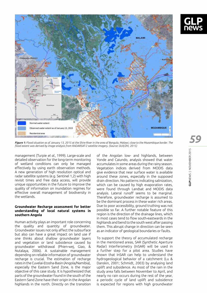
GL
PN
EWS
| N
OV
EMB
ER 2
01
5
59
Feat
ure
- Art
icle
management (Turpie et al., 1999). Large-scale and detailed observation for the long-term monitoring of wetland conditions can only be managed e━ectively by using earth observation methods. A new generation of high resolution optical and radar satellite systems (e.g. Sentinel 1,2) with high revisit times and free data access, will provide unique opportunities in the future to improve the quality of information on inundation regimes for e━ective overall management of biodiversity in the wetlands.
Groundwater Recharge assessment for better understanding of local natural systems in southern Angola
Human activity plays an important role concerning the quality and quantity of groundwater. Groundwater issues not only a━ect the subsurface but also can have a great impact on land use if one thinks about shallow groundwater layers and vegetation or land subsidence caused by groundwater withdrawal (Phien-wej, Giao, & Nutalaya, 2006). A sustainable management depending on reliable information of groundwater recharge is crucial. The estimation of recharge rates in the Cuvelai-Etosha-Basin (Angola/Namibia), especially the Eastern Sand Zone, is the major objective of this case study. It is hypothesized that parts of the groundwater found in the south of the Eastern Sand Zone have their origin in the Angolan highlands in the north. Directly on the transition
of the Angolan low- and highlands, between Yonde and Caiundo, analysis showed that water accumulates in some areas during the rainy season. Vegetation indices derived from MODIS data give evidence that near surface water is available around these zones, especially in the supposed drain direction. No patterns indicating salinization, which can be caused by high evaporation rates, were found through Landsat and MODIS data analysis. Lateral runo━ seems to be marginal. Therefore, groundwater recharge is assumed to be the dominant process in these water rich areas. Due to poor accessibility, ground truthing was not possible so far. A further notable feature of this region is the direction of the drainage lines, which in most cases tend to ┅ow south-eastwards in the highlands and bend to the south west after passing them. This abrupt change in direction can be seen as an indicator of geological boundaries or faults.
To support the theory of accumulated recharge in the mentioned areas, SAR (Synthetic Aperture Radar) Interferometry (InSAR) will be used in a further step for a pilot area. Studies have shown that InSAR can help to understand the hydrogeological behavior of a catchment (Lu & Danskin, 2001; Schmidt, 2003) by analysing land uplift and subsidence. As most of the rain in the study area falls between November to April, and nearly no rain occurs during the rest of the year, a periodic cycle of land uplift and subsidence is expected for regions with high groundwater
Figure 1: Flood situation as of January 13, 2015 at the Shire River in the area of Bangula, Malawi, close to the Mozambique border. The ┅ood extent was derived by image analysis from RADARSAT-2 satellite imagery. (Source: DLR/ZKI, 2015)
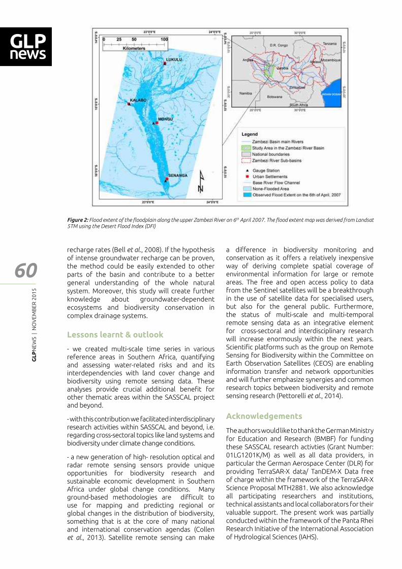
GL
PN
EWS
| N
OV
EMB
ER 2
01
5
60
recharge rates (Bell et al., 2008). If the hypothesis of intense groundwater recharge can be proven, the method could be easily extended to other parts of the basin and contribute to a better general understanding of the whole natural system. Moreover, this study will create further knowledge about groundwater-dependent ecosystems and biodiversity conservation in complex drainage systems.
Lessons learnt & outlook
- we created multi-scale time series in various reference areas in Southern Africa, quantifying and assessing water-related risks and and its interdependencies with land cover change and biodiversity using remote sensing data. These analyses provide crucial additional bene┃t for other thematic areas within the SASSCAL project and beyond.
- with this contribution we facilitated interdisciplinary research activities within SASSCAL and beyond, i.e. regarding cross-sectoral topics like land systems and biodiversity under climate change conditions.
- a new generation of high- resolution optical and radar remote sensing sensors provide unique opportunities for biodiversity research and sustainable economic development in Southern Africa under global change conditions. Many ground-based methodologies are di┆cult to use for mapping and predicting regional or global changes in the distribution of biodiversity, something that is at the core of many national and international conservation agendas (Collen et al., 2013). Satellite remote sensing can make
Figure 2: Flood extent of the ┅oodplain along the upper Zambezi River on 6th April 2007. The ┅ood extent map was derived from Landsat 5TM using the Desert Flood Index (DFI)
a di━erence in biodiversity monitoring and conservation as it o━ers a relatively inexpensive way of deriving complete spatial coverage of environmental information for large or remote areas. The free and open access policy to data from the Sentinel satellites will be a breakthrough in the use of satellite data for specialised users, but also for the general public. Furthermore, the status of multi-scale and multi-temporal remote sensing data as an integrative element for cross-sectoral and interdisciplinary research will increase enormously within the next years. Scienti┃c platforms such as the group on Remote Sensing for Biodiversity within the Committee on Earth Observation Satellites (CEOS) are enabling information transfer and network opportunities and will further emphasize synergies and common research topics between biodiversity and remote sensing research (Pettorelli et al., 2014).
Acknowledgements
The authors would like to thank the German Ministry for Education and Research (BMBF) for funding these SASSCAL research activties (Grant Number: 01LG1201K/M) as well as all data providers, in particular the German Aerospace Center (DLR) for providing TerraSAR-X data/ TanDEM-X Data free of charge within the framework of the TerraSAR-X Science Proposal MTH2881. We also acknowledge all participating researchers and institutions, technical assistants and local collaborators for their valuable support. The present work was partially conducted within the framework of the Panta Rhei Research Initiative of the International Association of Hydrological Sciences (IAHS).
Feat
ure
- Art
icle
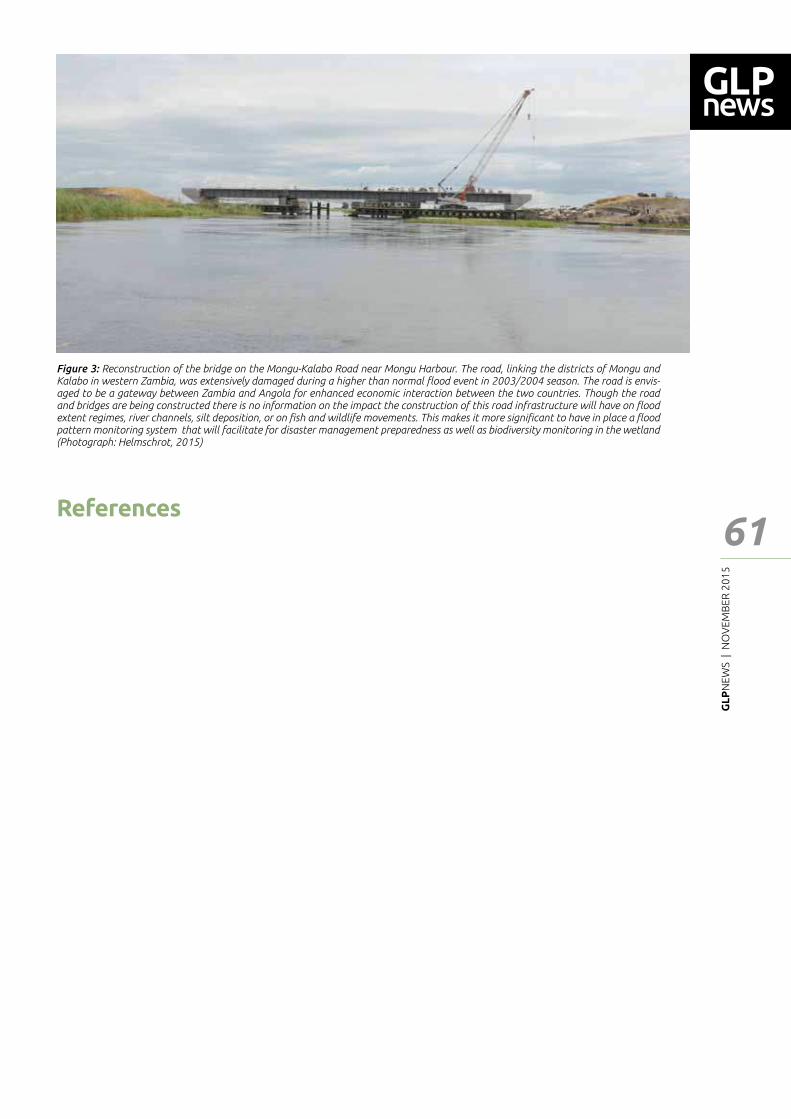
GL
PN
EWS
| N
OV
EMB
ER 2
01
5
61
Feat
ure
- Art
icle
Figure 3: Reconstruction of the bridge on the Mongu-Kalabo Road near Mongu Harbour. The road, linking the districts of Mongu and Kalabo in western Zambia, was extensively damaged during a higher than normal ┅ood event in 2003/2004 season. The road is envis-aged to be a gateway between Zambia and Angola for enhanced economic interaction between the two countries. Though the road and bridges are being constructed there is no information on the impact the construction of this road infrastructure will have on ┅ood extent regimes, river channels, silt deposition, or on ┃sh and wildlife movements. This makes it more signi┃cant to have in place a ┅ood pattern monitoring system that will facilitate for disaster management preparedness as well as biodiversity monitoring in the wetland (Photograph: Helmschrot, 2015)
References
Bell, J. W., Amelung, F., Ferretti, A., Bianchi, M., & Novali, F. (2008). Monitoring aquifer-system response to groundwater pumping and arti┃cial recharge. First Break, 26(8), 85–91. doi:10.1029/2007WR006152
Collen, B., Pettorelli, N., Baillie J.E.M., Durant, S. (2013). Biodiversity monitoring and conservation: bridging the gap between global commitment and local action. Cambridge, UK: Wiley-Blackwell.
Guzinski, R., Kass, S., Huber, S., Bauer-Gottwein, P., Jensen, I.H., Naeimi, V., Doubkova, M., Walli, A., Tottrup, C. (2014). Enabling the Use of Earth Observation Data for Integrated Water Resource Management in Africa with the Water Observation and Information System. In: Remote Sensing (6), p. 7018-739, doi:10.3390/rs6087819, ISSN 2072-4292
Hazarika, N., Das, A.K., Borah, S.B. (2015). Assessing land-use changes driven by river dynamics in chronically ┅ood a━ected Upper Brahmaputra plains, India, using RS-GIS techniques. In: The Egyptian Journal of Remote Sensing and Space Sciences 18, p. 107-118
Helmschrot, J. & Jürgens, N. (2015). Integrated SASSCAL research to assess and secure current and future water resources in Southern Africa. Hydrological Sciences and Water Security: Past, Present and Future (Proceedings of the 11th Kovacs Colloquium, Paris, France, June 2014). IAHS Publ. 366, 2014. Doi: 10.5194/piahs-366-168-2015.
Lu, Z., & Danskin, W. R. (2001). InSAR analysis of natural recharge to de┃ne structure of a ground-water basin, San Bernardino, California. Geophysical Research Letters, 28(13), 2661–2664. doi:10.1029/2000GL012753
Martinis, S., Twele, A., Strobl, C., Kersten, J., Stein, E. (2013). A Multi-Scale Flood Monitoring System Based on Fully Automatic MODIS and TerraSAR-X Processing Chains. Remote Sensing 5, 5598-5619. DOI: 10.3390/rs5115598. ISSN 2072-4292.
Martinis, S., Kuenzer, C., Twele, A. (2015). Flood studies using Synthetic Aperture Radar data. Remote Sensing of Water Resources, Disasters and Urban Studies, Taylor and Francis, submitted.
Pettorelli, N., Sa┃, K., Turner, W. (2014). Satellite remote sensing, biodiversity research and conservation of the future. Phil.Trans. R. Soc. B 369: 20130190. http://dx.doi.org/10.1098/rstb.2013.0190
Phien-wej, N., Giao, P. H., & Nutalaya, P. (2006). Land subsidence in Bangkok, Thailand. Engineering Geology, 82(4), 187–201. doi:10.1016/j.enggeo.2005.10.004
RAMSAR (2014). Introducing the Convention on Wetlands. RAMSAR Secretariat, Gland (http://www.ramsar.org/sites/default/┃les/documents/library/introducing_ramsar_web_eng.pdf)
Schmidt, D. A. (2003). Time-dependent land uplift and subsidence in the Santa Clara valley, California, from a large interferometric synthetic aperture radar data set. Journal of Geophysical Research, 108(B9), 1–13. doi:10.1029/2002JB002267
Tshilunga, S. (2014). A study of the 2011 ┅oods on human security in Namibia: A case study of the Oshoopala informal settlement in Oshakati. Master thesis, University of Namibia.
Turpie, J., Smith, B., Emerton, L., Barnes, J. (1999). Economic value of the Zambesi basin wetlands. IUCN – The World Conservation Union Regional O┆ce for Southern Africa, Harare
GL
PN
EWS
| N
OV
EMB
ER 2
01
5
62
Feat
ure
- Art
icle
Territorial approaches to enhance biodiversity in rural Europe
1 Groupe de Bruges, 2 Leitrim Organic, 3 Plateforme Capitalisation & Innovations Agricultures Familiales, 4 Czech University of Life SciencesCorresponding author: [email protected]
Anna Augustyn1 | John Brennan1,2 | Samuel Féret1,3 | Zdenek Linhart1,4 Bart Soldaat1
Introduction
In Europe there is an increasing sense of urgency to halt the ongoing loss of biodiversity and landscape values. In the context of agricultural practices, this also means a growing concern on the overall sustainability of agricultural production and natural resource management. These are major challenges to all government levels, to farmers and to many other stakeholders, including civil society.
Responding to these, in 2013-14 Groupe de Bruges set up an international transdsciplinary platform intended to explore territorial approaches addressing biodiversity in the context of the EU Common Agricultural Policy (CAP). Involved participants were scientists, policy makers and practictioners from across the continent. The group aimed to synthesise relevant scienti┃c resources and evidence-based case studies from various countries, in order to develop tailored policy recommendations and practical action points. Three major events were organised, in France, Netherlands and Belgium, that brought together numerous stakeholders to discuss and design the future policy agendas. The joint message resulting from this e━ort was passed to the EU-level decision makers.
Biodiversity loss as a collective concern
This collaborative work conveyed the following outcomes. First of all, territorial approaches were highlighted as an important trigger of reversing the biodiversity loss in the Europe�s rural areas. Frequently, they have been emerging in a grass-roots and innovative spirit, but also gained signi┃cant attention as elements of public policies. For instance the CAP created speci┃c incentives encouraging cooperation of farmers, in order to improve the state of biodiversity. The rationale for this was also to value public goods and strengthen institutions to govern common -pool resources (sensu Ostrom 1990).
The Groupe de Bruges took a closer look at 10 initiatives (case studies) that have positively contributed to enhancing biodiversity. They di━ered in type of region (marginal versus highly productive), type of sector, objectives and organisational structure. What they shared was the conviction that through territorial cooperation they could improve delivery of public goods and strike a better balance at farm level between economic and environmental objectives. They were identi┃ed in several EU countries. However case studies from countries that joined the EU in the last decade, undergoing post-socialist transformation, were more rare. In general, the following types of intiatives were distinguished:
(1) Initiatives aiming at mutual learning, encouraging sustainable (agro-ecological) practices, sometimes in combination with the marketing of regional products. These initiatives have a demarcated group and territory, but lack a legal entity and/or a regional plan.
(2) Initiatives that have (created) a legal representation and are operating on the basis of a plan covering a geographical area.
(3) Initiatives that have created a legal basis, have a strategy or plan and are (joint) bene┃ciaries of agri-environmental schemes or packages.
Secondly, territorial approaches were highlighted in the context of new CAP (2014-20). This EU policy co-┃nances national schemes targeting biodiversity, including ┅ora and fauna, rare breeds and crops, sometimes also functional agro-biodiversity and life support functions such as soil biodiversity. In addition, the support is provided to landscape (landscape features, cultural heritage), water quality (especially relating to the EU Water Framework Directive), water quantity (e.g. storage, increasing water tables) as well as energy and climate (e.g. carbon sequestration). Such goods and services are only compensated for, basing on the foregone income. Next to these, more sustainable farming systems
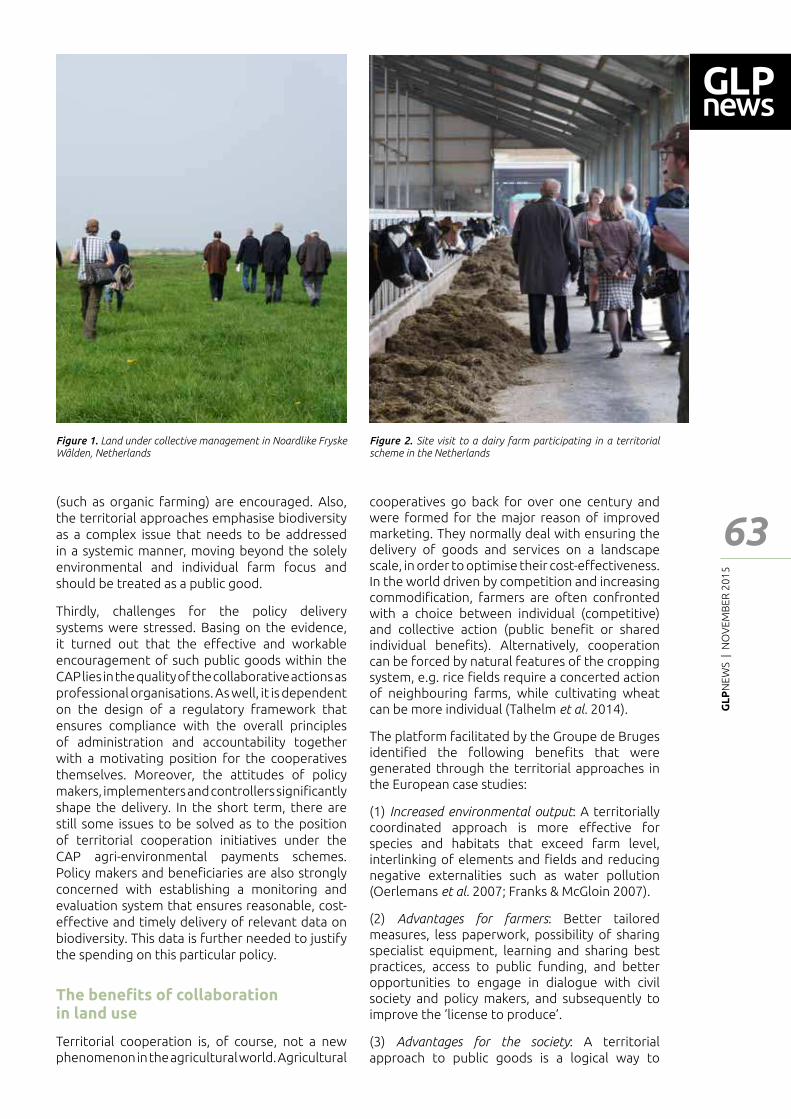
GL
PN
EWS
| N
OV
EMB
ER 2
01
5
63
Feat
ure
- Art
icle
(such as organic farming) are encouraged. Also, the territorial approaches emphasise biodiversity as a complex issue that needs to be addressed in a systemic manner, moving beyond the solely environmental and individual farm focus and should be treated as a public good.
Thirdly, challenges for the policy delivery systems were stressed. Basing on the evidence, it turned out that the e━ective and workable encouragement of such public goods within the CAP lies in the quality of the collaborative actions as professional organisations. As well, it is dependent on the design of a regulatory framework that ensures compliance with the overall principles of administration and accountability together with a motivating position for the cooperatives themselves. Moreover, the attitudes of policy makers, implementers and controllers signi┃cantly shape the delivery. In the short term, there are still some issues to be solved as to the position of territorial cooperation initiatives under the CAP agri-environmental payments schemes. Policy makers and bene┃ciaries are also strongly concerned with establishing a monitoring and evaluation system that ensures reasonable, cost-e━ective and timely delivery of relevant data on biodiversity. This data is further needed to justify the spending on this particular policy.
The bene┃ts of collaboration in land use
Territorial cooperation is, of course, not a new phenomenon in the agricultural world. Agricultural
cooperatives go back for over one century and were formed for the major reason of improved marketing. They normally deal with ensuring the delivery of goods and services on a landscape scale, in order to optimise their cost-e━ectiveness. In the world driven by competition and increasing commodi┃cation, farmers are often confronted with a choice between individual (competitive) and collective action (public bene┃t or shared individual bene┃ts). Alternatively, cooperation can be forced by natural features of the cropping system, e.g. rice ┃elds require a concerted action of neighbouring farms, while cultivating wheat can be more individual (Talhelm et al. 2014).
The platform facilitated by the Groupe de Bruges identi┃ed the following bene┃ts that were generated through the territorial approaches in the European case studies:
(1) Increased environmental output: A territorially coordinated approach is more e━ective for species and habitats that exceed farm level, interlinking of elements and ┃elds and reducing negative externalities such as water pollution (Oerlemans et al. 2007; Franks & McGloin 2007).
(2) Advantages for farmers: Better tailored measures, less paperwork, possibility of sharing specialist equipment, learning and sharing best practices, access to public funding, and better opportunities to engage in dialogue with civil society and policy makers, and subsequently to improve the �license to produce�.
(3) Advantages for the society: A territorial approach to public goods is a logical way to
Figure 1. Land under collective management in Noardlike Fryske Wâlden, Netherlands
Figure 2. Site visit to a dairy farm participating in a territorial scheme in the Netherlands
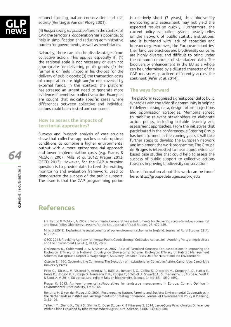
GL
PN
EWS
| N
OV
EMB
ER 2
01
5
64
Feat
ure
- Art
icle
connect farming, nature conservation and civil society (Renting & Van der Ploeg 2001).
(4) Budget saving for public policies: In the context of CAP, the terrotorial cooperation has a potential to help in simpli┃cation and reducing administrative burden for governments, as well as bene┃ciaries.
Naturally, there can also be disadvantages from collective action. This applies especially if: (1) the regional scale is not necessary or even not appropriate for delivering public goods; (2) the farmer is or feels limited in his choices for the delivery of public goods; (3) the transaction costs of cooperation are high and/or not covered by external funds. In this context, the platform has stressed an urgent need to generate more evidence of bene┃ts on collective action. Examples are sought that indicate speci┃c cases where di━erences between collective and individual actions could been tested and compared.
How to assess the impacts of territorial approaches?
Surveys and in-depth analysis of case studies show that collective approaches create optimal conditions to combine a higher environmental output with a more entrepreneurial approach and lower implementation costs (e.g. Franks & McGloin 2007; Mills et al. 2012; Prager 2013; OECD 2013). However, for the CAP a burning question is to provide data to feed the existing monitoring and evaluation framework, used to demonstrate the success of the public support. The issue is that the CAP programming period
is relatively short (7 years), thus biodiversity monitoring and assessment may not yield the expected results so quickly. Furthermore, the current policy evaluation system, heavily relies on the network of public statistic institutions, and is burdened with lack of capacities and bureaucracy. Moreover, the European countries, their land use practices and biodiversity concerns are highly diverse, and di┆cult to bring under the common umbrella of standarized data. The biodiversity enhancement in the EU as a whole can be undermined by a dilluted character of the CAP measures, practiced di━erently across the continent (Pe�er et al. 2014).
The ways forward
The platform recognised a great potential to build synergies with the scienti┃c community in helping to deliver missing data, design future projections and optimisation strategies. Members agreed to mobilise relevant stakeholders to elaborate action points, including suitable learning and assessment approaches. From the initiatives that participated in the conferences, a Steering Group has been formed. In the coming years it will take further steps to develop the European network and implement the work programme. The Groupe de Bruges is interested to hear about evidence-based case studies that could help to assess the success of public support to collective actions towards improving biodiversity conservation.
More information about this work can be found here: http://groupedebruges.eu/projects
References
Franks J. R. & McGloin, A. 2007. Environmental Co-operatives as Instruments for Delivering across-farm Environmental and Rural Policy Objectives: Lessons for the UK. Journal of Rural Studies, 23: 472-489.
Mills, J. (2012). Exploring the social benefits of agri-environment schemes in England. Journal of Rural Studies, 28(4), 612-621.
OECD 2013. Providing Agri-environmental Public Goods through Collective Action. Joint Working Party on Agriculture and the Environment (JWPAE), OECD, Paris.
Oerlemans N., Guldemond J. A. & Visser A. 2007. Role of Farmland Conservation Associations in Improving the Ecological Efficacy of a National Countryside Stewardship Scheme. Ecological Efficacy of Habitat Management Schemes, Background Report 3. Wageningen, Statutory Research Tasks Unit for Nature and the Environment.
Ostrom E. 1990. Governing the Commons: The Evolution of Institutions for Collective Action. Cambridge: Cambridge University Press.
Pe�er G., Dicks L. V., Visconti P., Arlettaz R., Báldi A., Benton T. G., Collins S., Dieterich M., Gregory R. D., Hartig F., Henle K., Hobson P. R., Kleijn D., Neumann R. K., Robijns T., Schmidt J., Shwartz A., Sutherland W. J., Turbé A., Wulf F. & Scott A. V. 2014. EU agricultural reform fails on biodiversity. Science, 344(6188): 1090-1092.
Prager K. 2013. Agri-environmental collaboratives for landscape management in Europe. Current Opinion in Environmental Sustainability, 12: 59�66.
Renting, H. & van der Ploeg J. D. 2001. Reconnecting Nature, Farming and Society: Environmental Cooperatives in the Netherlands as Institutional Arrangements for Creating Coherence. Journal of Environmental Policy & Planning, 3: 85-101.
Talhelm T., Zhang X., Oishi S., Shimin C., Duan D., Lan X. & Kitayama S. 2014. Large-Scale Psychological Differences Within China Explained by Rice Versus Wheat Agriculture. Science, 344(6184): 603-608.
GL
PN
EWS
| N
OV
EMB
ER 2
01
5
65
Feat
ure
- Art
icle
Global mangrove mapping: a critical tool for conservation
Arimatéa de Carvalho Ximenes1
Abstract
Mangroves are woody vegetation communities composed by plants that grow normally in tropical and subtropical latitudes along the land-sea interface and have developed special adaptations to cope with salinity and anoxic conditions. Such environments provide habitat for migratory species, refuge for juvenile organisms. Many marine and freshwater species use mangroves as reproduction sites. However, losses of mangrove forest have exceeded those of tropical rain forests and coral reefs. For this reason, the global mapping of mangroves areas is important in order to measure the rate of deforestation, estimated carbon storage, de┃ne the mangrove limits and support conservation actions. Until now, a number of mangrove mappings have been made using di━erent methods. This article will brie┅y discuss the most recent global mappings for mangroves and their application in conservation projects.
1 Université Libre de Bruxelles (ULB) and Vrije Universiteit Brussel (VUB) Avenue F.D. Roosevelt 50, CPI 264/1, B-1050 Bruxelles, Belgium.Corresponding author: [email protected]
scale are directly or indirectly dependent on mangroves (Ellison, 2008). Mangroves are also a habitat for migratory species and a refuge for juvenile ┃sh and crustaceans, and provide an ideal environment for the reproduction of many species (Primavera, 1998).
After several studies in areas a━ected by natural disasters, mangroves have been recognized as an ecosystem that protects coastal areas from tsunamis, storms and others natural disasters (Alongi, 2008; Dahdouh-Guebas et al., 2005).
Furthermore, the mangrove plants have important medicinal properties and can be used to cure several diseases (Bandaranayake, 1998). As an example, the Rhizophora mangle which is one of the most common species in the Atlantic East Paci┃c (AEP) biogeographical region which include the coastal areas in western and eastern Americas and western Africa (Duke, 1992) possesses many medicinal uses for the treatment of malaria, dysentery, leprosy, tuberculosis, and others (Bandaranayake, 1998).
Estimates suggest that mangroves provide more than $ 1.6 billion per year in environmental services (Costanza et al., 1997), although this number may be higher if we could compute all services provided by this ecosystem. Despite a clear importance of mangroves to maintain the stability of the ecosystems on a global scale, the mangroves have been under pressure by anthropogenic actions that will be discussed below.
Mangroves under pressure
At least 35% of the area of mangrove forests has been lost during 1980�s and 1990�s, a destruction that exceeds that of tropical rain forests and coral reefs, two other well-known threatened environments (Valiela et al., 2001). In this way, studies suggest that if deforestation continues at the same pace, mangroves could globally disappear in less than 100 years (Duke
Introduction
Mangroves are woody vegetation communities composed of plants that grow normally in tropical a subtropical latitudes along the land-sea interface, bays, estuaries, lagoons, backwaters, and in the rivers, reaching upstream up to the point where the water still remains saline (Qasim, 1998) where organisms have developed special adaptations in order to survive in this particular environment (Spalding et al., 2010).
Mangroves cover only 0.1% of the earth�s continental surface (FAO, 2003), and comprise about 0.7% of the total tropical forests of the world (Giri et al., 2011). Despite the limited total area, mangroves account for 11% of the total input of terrestrial carbon into the ocean (Jennerjahn & Ittekot, 2002), and it is estimated that 80% of ┃sh caught in the ocean on a global
GL
PN
EWS
| N
OV
EMB
ER 2
01
5
66
et al., 2007). Unfortunately, the mangroves are critically endangered in at least 26 countries (FAO, 2003). This means that mangrove ecosystems are under threat in more than one fourth of their country occurrence.
According to the International Union for Conservation of Nature (IUCN) Red List criteria categories of endangered species, up to 11 mangrove plants species are at high risk of extinction (Polidoro et al., 2010). The fauna also has more than 40% of mangrove-endemic vertebrates that are globally threatened (Luther & Greenberg, 2009). For example, the only record of a species of frog restricted to mangrove and endemic in Haiti called Eleutherodactylus caribe is threatened by habitat loss (IUCN, 2010) due to the conversion of mangroves into others land uses. Nowadays, the environmental impact is not only at the species level, but also at the level of ecosystems as a whole.
The greatest drivers for mangrove forest loss are direct conversion to aquaculture, agriculture, urban land uses (Spalding et al., 2010) and tourism infrastructure (FAO, 2007). These drivers are also linked to the fact that almost half (44%) of the world�s population lives within 150 km of the sea, and three-quarters of all large cities are located on the coasts (Cohen et al., 1997), where mangrove ecosystem grow naturally. The remaining mangrove forests are under pressure from clear-cutting, land-use change, hydrological alterations and chemical spill (Blasco et al., 2001). In addition, scenarios of climate change related to sea level rise are presented as a great threat for mangroves (Gilman et al., 2008). In the past, due to sea level changes mangroves have migrated in order to adapt and colonize new suitable areas. Nowadays, in many cases the surroundings of mangroves are already occupied by cities, agriculture and others land uses. Since mangroves have no natural areas to migrate to in case of sea level rise; the impacts may be greater than expected.
Moreover, mangroves have been impacted by huge coastal projects, such as ports and interoceanic channels. For instance, Meyer and Huete-Pérez (2014) have highlighted the environmental impact of the construction of a massive interoceanic channel to connect the Atlantic to Paci┃c on Nicaragua�s ecosystems. Until now, hardly any research had been done speci┃cally about the impact of this project on mangroves in Nicaragua. The impact of the construction of the channel will be direct and indirect, through deforestation and through changes in the natural hydrodynamics of this region.
For this reason, the mapping of mangroves is extremely important to give us the dimension of the impacts and it may help decision makers to planning conservation actions, sustainability uses
and protection. The next topic will brie┅y discuss di━erent mappings for mangroves that have been used for many purposes.
Global Mangroves area estimation under di━erent mapping techniques
Estimating the mangrove forest areas is challenging. The wetlands tend to be di┆cult to map because they are quite dynamic and are often a gradient between terrestrial and aquatic ecosystems (Horning et al., 2010). Despite this challenge, di━erent global mapping techniques have been applied to estimate the mangrove forest areas. Moreover, according to the Food and Agriculture Organization of the United Nations (FAO, 2007) a regular update of information on the extent and condition of mangroves is needed as an aid to policy- and decision-making for the conservation, management and sustainable use of the world�s remaining mangrove ecosystems. This ecosystems mapping allows for biogeographic maps and ecoregions to be delimitated, and these are essential for the creation of reserves in areas that are ecologically representative (Spalding et al., 2007).
The ┃rst attempt at estimating the total mangrove area in the world was undertaken as part of the FAO and United Nations Environmental Programme (UNEP) with the project of Tropical Forest Resources Assessment in 1980, where the total mangrove area in 51 countries was estimated as 156,426 km2. The ┃rst World Mangrove Atlas mapped mangroves in 112 countries covering a total of 181,077 km2 (Spalding et al., 1997). The most recent estimations were made by Spalding et al. (2010) and Giri et al. (2011). The second World Atlas of Mangroves covers 123 countries and territories globally, and found a total of 152,000 km2 (Spalding et al., 2010), but Giri et
al. (2011) estimated 137,760 km2 of mangrove forest area in 118 countries and territories (Figure 1), though nearly 75% of their area occurs in just 15 countries.
The estimate of Giri et al. (2011) is approximately 10% smaller than the most recent estimate by Spalding et al. (2010). To compare di━erent mangrove mappings techniques, three mappings made by Spalding et al. (1997), Spalding et al. (2010) and Giri et al. (2011) were used. There are clear di━erences between Spalding et al. (2010) and Giri et al. (2011) mappings (Figure 1). The ┃rst World Atlas of Mangroves mapping (Spalding et al., 1997) was hand-drawn by experts, and combines information ranging from high and low-resolutions maps derived from remote sensing imagery. Observing ┃gure 1 it is possible to conclude that Spalding et al., 1997 did not dispose of all image coverage in the north Brazilian mangroves, probably because of the intense cloud coverage in this region.
Feat
ure
- Art
icle
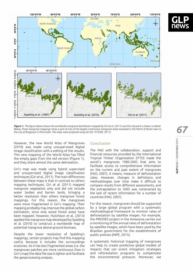
GL
PN
EWS
| N
OV
EMB
ER 2
01
5
67
Feat
ure
- Art
icle
However, the new World Atlas of Mangroves (2010) was made using unsupervised digital image classi┃cation with a editing of the results. This new mapping of the World Atlas has ┃lled the empty gaps from the old version (Figure 1), and they share almost the same delineation.
Giri�s map was made using hybrid supervised and unsupervised digital image classi┃cation techniques (Giri et al., 2011). The main di━erences between these maps is that in contrast to others mapping techniques, Giri et al. (2011) mapped mangrove vegetation only and did not include water bodies and barren lands, bringing a better resolution than others mangrove forest mappings. For this reason, the mangroves were more fragmented in Giri�s mapping. Their mapping probably may improve the global carbon estimation, since only wood forest areas have been mapped. However, Hutchison et al., (2013) applied the mangrove map developed by Spalding et al. (2010) to construct a worldwide map of potential mangrove above-ground biomass.
Despite the lower resolution of Spalding�s mappings, certain projects may ┃nd this mapping useful, because it includes the surroundings ecotones. As it has less fragmented areas (i.e. the mangroves patches are more continuous than in Giri’s map) the data ┃le size is lighter and facilitate the geoprocessing analysis.
Conclusion
The FAO with the collaboration, support and ┃nancial resources provided by the International Tropical Timber Organization (ITTO) made the world`s mangroves 1980-2005 that aims to facilitate access to comprehensive information on the current and past extent of mangroves (FAO, 2007), it means, measure of deforestation rates. However, changes in de┃nitions and methodologies over time make it di┆cult to compare results from di━erent assessments, and the extrapolation to 2005 was constrained by the lack of recent information for a number of countries (FAO, 2007).
For this reason, mangroves should be supported by a large global program with a systematic methodological framework to monitor rates of deforestation by satellite images. For example, the PRODES project in the Amazonia carries out a monitoring of the annual rates of deforestation by satellite images, which have been used by the Brazilian government for the establishment of public policies (INPE, 2015).
A systematic historical mapping of mangroves can help to create predictive global models of impacts that can orient mitigation strategies and reforestation programs to compensate the environmental pressure. Moreover, we
Figure 1. The ┃gure above shows the worldwide mangrove distribution mapped by Giri et al. (2011) and the red point is shown in detail. Below, three mangrove mappings show a part of one of the largest continuous mangrove areas localized in the North of Brazil near to the city of Bragança in Pará state. The maps were prepared using ArcGIS 10 (ESRI, 2011).
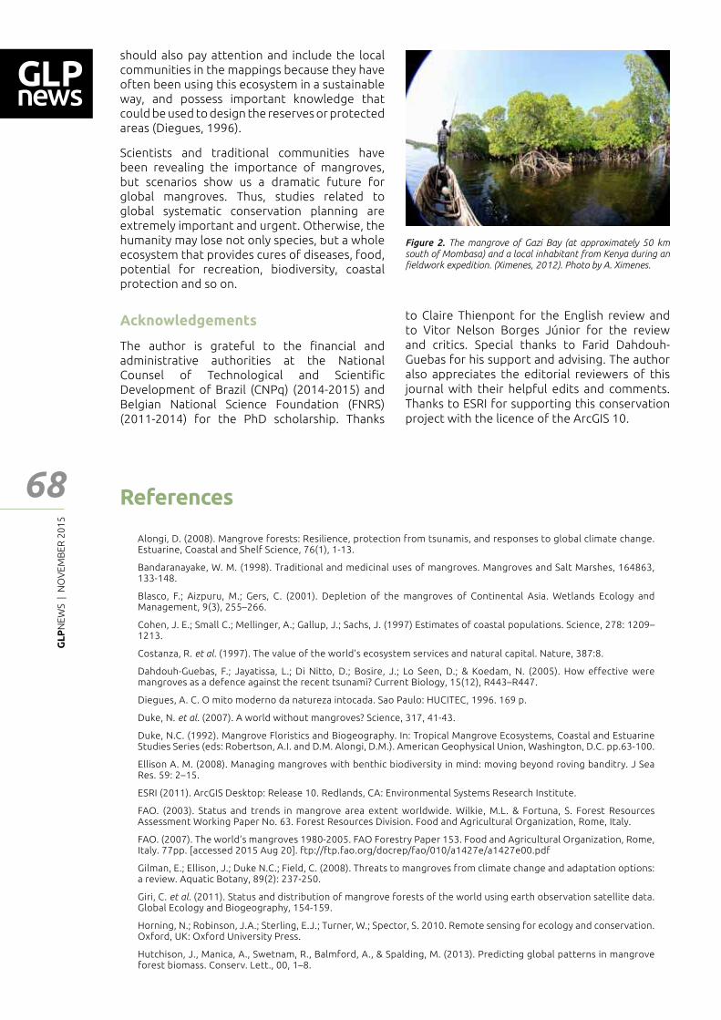
GL
PN
EWS
| N
OV
EMB
ER 2
01
5
68 References
Alongi, D. (2008). Mangrove forests: Resilience, protection from tsunamis, and responses to global climate change. Estuarine, Coastal and Shelf Science, 76(1), 1-13.
Bandaranayake, W. M. (1998). Traditional and medicinal uses of mangroves. Mangroves and Salt Marshes, 164863, 133-148.
Blasco, F.; Aizpuru, M.; Gers, C. (2001). Depletion of the mangroves of Continental Asia. Wetlands Ecology and Management, 9(3), 255�266.
Cohen, J. E.; Small C.; Mellinger, A.; Gallup, J.; Sachs, J. (1997) Estimates of coastal populations. Science, 278: 1209�1213.
Costanza, R. et al. (1997). The value of the world�s ecosystem services and natural capital. Nature, 387:8.
Dahdouh-Guebas, F.; Jayatissa, L.; Di Nitto, D.; Bosire, J.; Lo Seen, D.; & Koedam, N. (2005). How effective were mangroves as a defence against the recent tsunami? Current Biology, 15(12), R443�R447.
Diegues, A. C. O mito moderno da natureza intocada. Sao Paulo: HUCITEC, 1996. 169 p.
Duke, N. et al. (2007). A world without mangroves? Science, 317, 41-43.
Duke, N.C. (1992). Mangrove Floristics and Biogeography. In: Tropical Mangrove Ecosystems, Coastal and Estuarine Studies Series (eds: Robertson, A.I. and D.M. Alongi, D.M.). American Geophysical Union, Washington, D.C. pp.63-100.
Ellison A. M. (2008). Managing mangroves with benthic biodiversity in mind: moving beyond roving banditry. J Sea Res. 59: 2�15.
ESRI (2011). ArcGIS Desktop: Release 10. Redlands, CA: Environmental Systems Research Institute.
FAO. (2003). Status and trends in mangrove area extent worldwide. Wilkie, M.L. & Fortuna, S. Forest Resources Assessment Working Paper No. 63. Forest Resources Division. Food and Agricultural Organization, Rome, Italy.
FAO. (2007). The world�s mangroves 1980-2005. FAO Forestry Paper 153. Food and Agricultural Organization, Rome, Italy. 77pp. [accessed 2015 Aug 20]. ftp://ftp.fao.org/docrep/fao/010/a1427e/a1427e00.pdf
Gilman, E.; Ellison, J.; Duke N.C.; Field, C. (2008). Threats to mangroves from climate change and adaptation options: a review. Aquatic Botany, 89(2): 237-250.
Giri, C. et al. (2011). Status and distribution of mangrove forests of the world using earth observation satellite data. Global Ecology and Biogeography, 154-159.
Horning, N.; Robinson, J.A.; Sterling, E.J.; Turner, W.; Spector, S. 2010. Remote sensing for ecology and conservation. Oxford, UK: Oxford University Press.
Hutchison, J., Manica, A., Swetnam, R., Balmford, A., & Spalding, M. (2013). Predicting global patterns in mangrove forest biomass. Conserv. Lett., 00, 1�8.
Figure 2. The mangrove of Gazi Bay (at approximately 50 km south of Mombasa) and a local inhabitant from Kenya during an ┃eldwork expedition. (Ximenes, 2012). Photo by A. Ximenes.
should also pay attention and include the local communities in the mappings because they have often been using this ecosystem in a sustainable way, and possess important knowledge that could be used to design the reserves or protected areas (Diegues, 1996).
Scientists and traditional communities have been revealing the importance of mangroves, but scenarios show us a dramatic future for global mangroves. Thus, studies related to global systematic conservation planning are extremely important and urgent. Otherwise, the humanity may lose not only species, but a whole ecosystem that provides cures of diseases, food, potential for recreation, biodiversity, coastal protection and so on.
Acknowledgements
The author is grateful to the ┃nancial and administrative authorities at the National Counsel of Technological and Scienti┃c Development of Brazil (CNPq) (2014-2015) and Belgian National Science Foundation (FNRS) (2011-2014) for the PhD scholarship. Thanks
to Claire Thienpont for the English review and to Vitor Nelson Borges Júnior for the review and critics. Special thanks to Farid Dahdouh-Guebas for his support and advising. The author also appreciates the editorial reviewers of this journal with their helpful edits and comments. Thanks to ESRI for supporting this conservation project with the licence of the ArcGIS 10.
Feat
ure
- Art
icle
GL
PN
EWS
| N
OV
EMB
ER 2
01
5
69
Feat
ure
- Art
icle
INSTITUTO NACIONAL DE PESQUISAS ESPACIAIS (INPE). Projeto PRODES: monitoramento da floresta amazônica brasileira por satélite. [accessed 2015 Aug 28]. <http://www.obt.inpe.br/prodes/>.
IUCN, 2010, IUCN Red List of Threatened Species. Version 2010.4. www.iucnredlist.org, International Union for Conservation of Nature and Natural Resources.
Jennerjahn, T.C.; Ittekot, V. (2002) Relevance of mangroves for the production and deposition of organic matter along tropical continental margins. Naturwissenschaften,89, 23�30.
Luther, D.A.; Greenberg, R. (2009). Mangroves: A Global Perspective on the Evolution and Conservation of Their Terrestrial Vertebrates. BioScience, 59 (7), 602-612.
Meyer, A.; Huete-Pérez, J.A. (2014) Conservation: Nicaragua canal could wreak environmental ruin. Nature. 506:287�289.
Polidoro, B. A. et al. (2010). The loss of species: mangrove extinction risk and geographic areas of global concern. PloS one, 5(4), e10095.
Primavera, J. H. (1998). Mangroves as nurseries: Shrimp populations in mangrove and non-mangrove hábitats. Estuarine, Coastal and Shelf Science, 46, 457-464.
Qasim, S.Z. (1998). Mangroves. In: Glimpses of the Indian Ocean, Qasim, S.Z. (Ed.). University Press, Hyderabad, India, ISBN-13: 9788173711299, pp: 123-129.
Spalding, M.D.; Blasco, F.; Field, C.D., eds. (1997). World Mangrove Atlas. The International Society for Mangrove Ecosystems, Okinawa, Japan. 178 pp.
Spalding, M. D. et al. (2007). Marine Ecoregions of the World: A bioregionalization of coastal and shelf areas. BioScience, 57 (7): 573-583.
Spalding, M.; Kainuma, M.; Collins, L. (2010). World Atlas of Mangroves. A collaborative project of ITTO, ISME, FAO, UNEP-WCMC, UNESCO-MAB, UNU-INWEH and TNC. London (UK): Earthscan, London. 319 pp. Data layer from the World Atlas of Mangroves. In Supplement to: Spalding et al. (2010a). Cambridge (UK): UNEP World Conservation Monitoring Centre. URL: data.unep-wcmc.org/datasets/22
Valiela, I.; Bowen, J. L.; York, J. K. (2001). Mangrove Forests: One of the World�s Threatened Major Tropical Environments. BioScience, 51(10), 807.
Ximenes, A. C. (2012). Fieldwork expedition in Gazi Bay, Kenya. Jan-Fev/2012.
GL
PN
EWS
| N
OV
EMB
ER 2
01
5
70
Feat
ure
- Art
icle
The Risk of Protection: The Dilemma between Wildlife Protection and Cropland Use under Ecological Restoration
1 College of Resources and Environment, Southwest University, No.1 Tiansheng Road, Beibei District, Chongqing 400716, P.R. China.Corresponding author: [email protected]
Xiaobo Hua1 | Jianzhong Yan1
Abstract
The majority of the world�s nations have taken some measures to protect biodiversity, which is potentially at great risk. Human-wildlife con┅ict (HWC) is one of the growing global issues, which seriously threatens agriculture production and livelihoods. Hence, clarifying the connection among wildlife protection, cropland use and livelihood under ecological restoration will help us understand the shortcomings of the recent policies toward wildlife protection and ecological restoration, as well as amend existing policies more e━ectively. Here we illustrate the dilemma between biodiversity and land systems by a typical case of China in order to raise concern in the academia and governments about this problem in other developing countries.
To improve biodiversity conservation and restore the functioning of ecosystems, which are under severe threats (Cardinale et al. 2012), di━erent measures, such as creating protected areas (e.g. national parks) and by making compensation schemes, have been tried worldwide (Bruner et al. 2001, Myers et al. 2000, Naughton-Treves, Holland and Brandon 2005, Chape et al. 2005, Rondeau and Bulte, 2007). Some studies have shown that such protecting measures, especially the overprotecting ones, do not e━ectively protect biodiversity (Kleijn et al. 2001), and in addition, negative e━ects on social-ecological systems have appeared (Cernea and Schmidt-Soltau 2006, Karki 2013). One of the most obvious risks is human-wildlife con┅ict (HWC), which has increased turning a great and worldwide concern nowadays (Distefano 2005, Sekhar 1998, Hartter, Goldman and Southworth 2011, Messmer 2000). HWC has signi┃cant impacts on agricultural land use and agricultural productions (Shu 2012, Distefano 2005, Madhusudan 2003, Sekhar 1998, Sreekar et al. 2013, Yu, Wu and Fan 2009, Wang, Curtis
and Lassoie 2006, Bleier et al. 2012). Besides, people a━ected by wildlife damage around the world often take some measures to protect local farming by using their indigenous knowledge (Hartter et al. 2011, Hough 1993, Thapa 2010).
In the context of HWC and land systems, there is a lack of empirical information, research and overall analytical framework on the connection between HWC and cropland use (such as wildlife damage and cropland abandonment) at micro-level. And we also know much less about decisions on cropland use under wildlife damage taken at household level.
According to the news reported online, we ┃nd that wild boar populations are now overly abundant in several provinces of China, resulting in damage to agricultural crops, native wildlife habitat and local livelihoods, which raise concerns among agricultural producers, wildlife managers and natural resource professionals (see Figure 1). There are two evident dilemmas or paradoxes between wildlife protection and cropland use under ecological restoration: (i) wildlife protection vs. farmers� welfare, and (ii) ecological restoration vs. livelihood security.
For better understanding, we demonstrate an example of practical dilemma among ecological restoration, land use transition, biodiversity and livelihood security (Figure 2). In order to restore the functioning of ecosystems, most nations have taken di━erent planning measures. In China, for example, the government has launched a series of state forest policies through top-down governmental intervention aiming for ecological conservation (Lambin and Meyfroidt 2010). In an e━ort to promote forest management activities preventing forest destruction and further deterioration, the Chinese government established the National Forest Conservation Programme (NFCP) in 1998 (Li 2004). Similar schemes, such as deforestation and forest degradation (REDD+) in other developing countries, are also set for protecting
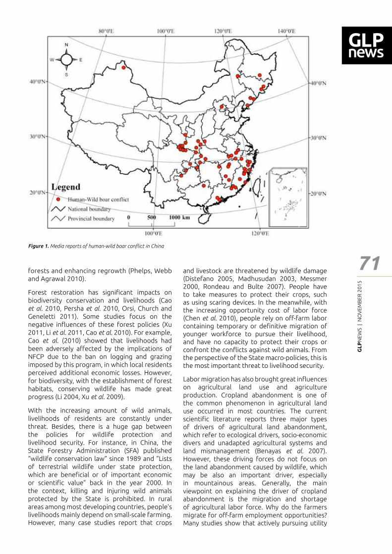
GL
PN
EWS
| N
OV
EMB
ER 2
01
5
71
Feat
ure
- Art
icle
Figure 1. Media reports of human-wild boar con┅ict in China
forests and enhancing regrowth (Phelps, Webb and Agrawal 2010).
Forest restoration has signi┃cant impacts on biodiversity conservation and livelihoods (Cao et al. 2010, Persha et al. 2010, Orsi, Church and Geneletti 2011). Some studies focus on the negative in┅uences of these forest policies (Xu 2011, Li et al. 2011, Cao et al. 2010). For example, Cao et al. (2010) showed that livelihoods had been adversely a━ected by the implications of NFCP due to the ban on logging and grazing imposed by this program, in which local residents perceived additional economic losses. However, for biodiversity, with the establishment of forest habitats, conserving wildlife has made great progress (Li 2004, Xu et al. 2009).
With the increasing amount of wild animals, livelihoods of residents are constantly under threat. Besides, there is a huge gap between the policies for wildlife protection and livelihood security. For instance, in China, the State Forestry Administration (SFA) published �wildlife conservation law� since 1989 and �Lists of terrestrial wildlife under state protection, which are bene┃cial or of important economic or scienti┃c value” back in the year 2000. In the context, killing and injuring wild animals protected by the State is prohibited. In rural areas among most developing countries, people�s livelihoods mainly depend on small-scale farming. However, many case studies report that crops
and livestock are threatened by wildlife damage (Distefano 2005, Madhusudan 2003, Messmer 2000, Rondeau and Bulte 2007). People have to take measures to protect their crops, such as using scaring devices. In the meanwhile, with the increasing opportunity cost of labor force (Chen et al. 2010), people rely on o━-farm labor containing temporary or de┃nitive migration of younger workforce to pursue their livelihood, and have no capacity to protect their crops or confront the con┅icts against wild animals. From the perspective of the State macro-policies, this is the most important threat to livelihood security.
Labor migration has also brought great in┅uences on agricultural land use and agriculture production. Cropland abandonment is one of the common phenomenon in agricultural land use occurred in most countries. The current scienti┃c literature reports three major types of drivers of agricultural land abandonment, which refer to ecological drivers, socio-economic divers and unadapted agricultural systems and land mismanagement (Benayas et al. 2007). However, these driving forces do not focus on the land abandonment caused by wildlife, which may be also an important driver, especially in mountainous areas. Generally, the main viewpoint on explaining the driver of cropland abandonment is the migration and shortage of agricultural labor force. Why do the farmers migrate for o━-farm employment opportunities? Many studies show that actively pursuing utility
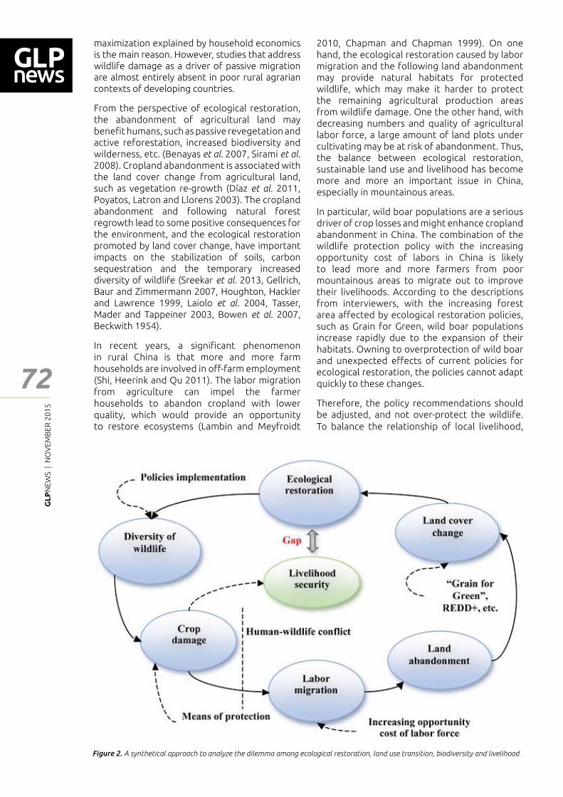
GL
PN
EWS
| N
OV
EMB
ER 2
01
5
72
Feat
ure
- Art
icle
Figure 2. A synthetical approach to analyze the dilemma among ecological restoration, land use transition, biodiversity and livelihood
maximization explained by household economics is the main reason. However, studies that address wildlife damage as a driver of passive migration are almost entirely absent in poor rural agrarian contexts of developing countries.
From the perspective of ecological restoration, the abandonment of agricultural land may bene┃t humans, such as passive revegetation and active reforestation, increased biodiversity and wilderness, etc. (Benayas et al. 2007, Sirami et al. 2008). Cropland abandonment is associated with the land cover change from agricultural land, such as vegetation re-growth (Díaz et al. 2011, Poyatos, Latron and Llorens 2003). The cropland abandonment and following natural forest regrowth lead to some positive consequences for the environment, and the ecological restoration promoted by land cover change, have important impacts on the stabilization of soils, carbon sequestration and the temporary increased diversity of wildlife (Sreekar et al. 2013, Gellrich, Baur and Zimmermann 2007, Houghton, Hackler and Lawrence 1999, Laiolo et al. 2004, Tasser, Mader and Tappeiner 2003, Bowen et al. 2007, Beckwith 1954).
In recent years, a signi┃cant phenomenon in rural China is that more and more farm households are involved in o━-farm employment (Shi, Heerink and Qu 2011). The labor migration from agriculture can impel the farmer households to abandon cropland with lower quality, which would provide an opportunity to restore ecosystems (Lambin and Meyfroidt
2010, Chapman and Chapman 1999). On one hand, the ecological restoration caused by labor migration and the following land abandonment may provide natural habitats for protected wildlife, which may make it harder to protect the remaining agricultural production areas from wildlife damage. One the other hand, with decreasing numbers and quality of agricultural labor force, a large amount of land plots under cultivating may be at risk of abandonment. Thus, the balance between ecological restoration, sustainable land use and livelihood has become more and more an important issue in China, especially in mountainous areas.
In particular, wild boar populations are a serious driver of crop losses and might enhance cropland abandonment in China. The combination of the wildlife protection policy with the increasing opportunity cost of labors in China is likely to lead more and more farmers from poor mountainous areas to migrate out to improve their livelihoods. According to the descriptions from interviewers, with the increasing forest area a━ected by ecological restoration policies, such as Grain for Green, wild boar populations increase rapidly due to the expansion of their habitats. Owning to overprotection of wild boar and unexpected e━ects of current policies for ecological restoration, the policies cannot adapt quickly to these changes.
Therefore, the policy recommendations should be adjusted, and not over-protect the wildlife. To balance the relationship of local livelihood,
GL
PN
EWS
| N
OV
EMB
ER 2
01
5
73
Feat
ure
- Art
icle
References
Beckwith, S. L. (1954) Ecological succession on abandoned farm lands and its relationship to wildlife management. Ecological Monographs, 24, 349-376.
Benayas, J. R., A. Martins, J. M. Nicolau & J. J. Schulz (2007) Abandonment of agricultural land: an overview of drivers and consequences. CAB reviews: perspectives in agriculture, veterinary science, nutrition and natural resources, 2, 1-14.
Bleier, N., R. Lehoczki, D. Újváry, L. Szemethy & S. Csányi (2012) Relationships between wild ungulates density and crop damage in Hungary. Acta Theriologica, 57, 351-359.
Bowen, M. E., C. A. McAlpine, A. P. House & G. C. Smith (2007) Regrowth forests on abandoned agricultural land: a review of their habitat values for recovering forest fauna. Biological Conservation, 140, 273-296.
Bruner, A. G., R. E. Gullison, R. E. Rice & G. A. Da Fonseca (2001) E━ectiveness of parks in protecting tropical biodiversity. Science, 291, 125-128.
Cao, S., X. Wang, Y. Song, L. Chen & Q. Feng (2010) Impacts of the Natural Forest Conservation Program on the livelihoods of residents of Northwestern China: perceptions of residents a━ected by the program. Ecological Economics, 69, 1454-1462.
Cardinale, B. J., J. E. Du━y, A. Gonzalez, D. U. Hooper, C. Perrings, P. Venail, A. Narwani, G. M. Mace, D. Tilman & D. A. Wardle (2012) Biodiversity loss and its impact on humanity. Nature, 486, 59-67.
Cernea, M. M. & K. Schmidt-Soltau (2006) Poverty risks and national parks: Policy issues in conservation and resettlement. World development, 34, 1808-1830.
Chape, S., J. Harrison, M. Spalding & I. Lysenko (2005) Measuring the extent and e━ectiveness of protected areas as an indicator for meeting global biodiversity targets. Philosophical Transactions of the Royal Society B: Biological Sciences, 360, 443-455.
Chapman, C. A. & L. J. Chapman (1999) Forest restoration in abandoned agricultural land: a case study from East Africa. Conservation Biology, 13, 1301-1311.
Chen, Y., X. Li, H. Zhu & W. Zhang (2010) Agricultural land use responses to increasing labor opportunity cost in Suixian County of Henan Province. Progress in Geography, 29, 1067-1074.
Díaz, G. I., L. Nahuelhual, C. Echeverría & S. Marín (2011) Drivers of land abandonment in Southern Chile and implications for landscape planning. Landscape and Urban Planning, 99, 207-217.
Distefano, E. (2005) Human-Wildlife Con┅ict worldwide: collection of case studies, analysis of management strategies and good practices. SARD. Initiative Report, FAO, Rome.
Gellrich, M., P. Baur & N. E. Zimmermann (2007) Natural forest regrowth as a proxy variable for agricultural land abandonment in the Swiss mountains: a spatial statistical model based on geophysical and socio-economic variables. Environmental modeling & assessment, 12, 269-278.
Hartter, J., A. Goldman & J. Southworth (2011) Responses by households to resource scarcity and human–wildlife con┅ict: Issues of fortress conservation and the surrounding agricultural landscape. Journal for Nature Conservation, 19, 79-86.
Hough, J. L. (1993) Why burn the bush? Social approaches to bush-┃re management in West African national parks. Biological Conservation, 65, 23-28.
Houghton, R., J. Hackler & K. Lawrence (1999) The US carbon budget: contributions from land-use change. Science, 285, 574-578.
Karki, S. T. (2013) Do protected areas and conservation incentives contribute to sustainable livelihoods? A case study of Bardia National Park, Nepal. Journal of environmental management, 128, 988-999.
Kleijn, D., F. Berendse, R. Smit & N. Gilissen (2001) Agri-environment schemes do not e━ectively protect biodiversity in Dutch agricultural landscapes. Nature, 413, 723-725.
Laiolo, P., F. Dondero, E. Ciliento & A. Rolando (2004) Consequences of pastoral abandonment for the structure and diversity of the alpine avifauna. Journal of Applied Ecology, 41, 294-304.
Lambin, E. F. & P. Meyfroidt (2010) Land use transitions: Socio-ecological feedback versus socio-economic change. Land use policy, 27, 108-118.
Li, J., M. W. Feldman, S. Li & G. C. Daily (2011) Rural household income and inequality under the Sloping Land Conversion Program in western China. Proceedings of the National Academy of Sciences, 108, 7721-7726.
Li, W. (2004) Degradation and restoration of forest ecosystems in China. Forest Ecology and Management, 201, 33-41.
Madhusudan, M. (2003) Living amidst large wildlife: livestock and crop depredation by large mammals in the interior villages of Bhadra Tiger Reserve, south India. Environmental Management, 31, 0466-0475.
sustainable land use and ecological restoration has become more and more important in China, especially in poor and mountainous areas, rather than unilaterally based on wildlife-oriented approach. In terms of the permanent cropland abandonment, the government at all levels (national, provincial and local government) should respect the local people�s willingness to return farmland to woodland. The government should rethink the increasing forest area and its signi┃cance to ecological restoration. Necessary
top-down protection measures, such as farmers `compensation scheme, should be taken by government to eliminate the negative e━ects of wild animals.
Funding
Financial support for this research was provided by the National Natural Science Foundation of China (No. 41161140352).
GL
PN
EWS
| N
OV
EMB
ER 2
01
5
74
Feat
ure
- Art
icle
Messmer, T. A. (2000) The emergence of human–wildlife con┅ict management: turning challenges into opportunities. International Biodeterioration & Biodegradation, 45, 97-102.
Myers, N., R. A. Mittermeier, C. G. Mittermeier, G. A. Da Fonseca & J. Kent (2000) Biodiversity hotspots for conservation priorities. Nature, 403, 853-858.
Naughton-Treves, L., M. B. Holland & K. Brandon (2005) The role of protected areas in conserving biodiversity and sustaining local livelihoods. Annu. Rev. Environ. Resour., 30, 219-252.
Orsi, F., R. L. Church & D. Geneletti (2011) Restoring forest landscapes for biodiversity conservation and rural livelihoods: A spatial optimisation model. Environmental Modelling & Software, 26, 1622-1638.
Persha, L., H. Fischer, A. Chhatre, A. Agrawal & C. Benson (2010) Biodiversity conservation and livelihoods in human-dominated landscapes: Forest commons in South Asia. Biological conservation, 143, 2918-2925.
Phelps, J., E. L. Webb & A. Agrawal (2010) Does REDD+ threaten to recentralize forest governance. Science, 328, 312-313.
Poyatos, R., J. Latron & P. Llorens (2003) Land use and land cover change after agricultural abandonment: the case of a Mediterranean mountain area (Catalan Pre-Pyrenees). Mountain Research and Development, 23, 362-368.
Rondeau, D. & E. Bulte (2007) Wildlife damage and agriculture: a dynamic analysis of compensation schemes. American Journal of Agricultural Economics, 89, 490-507.
Sekhar, N. U. (1998) Crop and livestock depredation caused by wild animals in protected areas: the case of Sariska Tiger Reserve, Rajasthan, India. Environmental Conservation, 25, 160-171.
Shi, X., N. Heerink & F. Qu (2011) Does o━-farm employment contribute to agriculture-based environmental pollution? New insights from a village-level analysis in Jiangxi Province, China. China Economic Review, 22, 524-533.
Shu, C. 2012. Mitigating Human-elephant con┅icts in Xishuangbanna, China. Singapore: National University of Singapore.
Sirami, C., L. Brotons, I. Bur┃eld, J. Fonder┅ick & J.-L. Martin (2008) Is land abandonment having an impact on biodiversity? A meta-analytical approach to bird distribution changes in the north-western Mediterranean. Biological Conservation, 141, 450-459.
Sreekar, R., A. Mohan, S. Das, P. Agarwal & R. Vivek (2013) Natural Windbreaks Sustain Bird Diversity in a Tea-Dominated Landscape. PloS one, 8, e70379.
Tasser, E., M. Mader & U. Tappeiner (2003) E━ects of land use in alpine grasslands on the probability of landslides. Basic and Applied Ecology, 4, 271-280.
Thapa, S. (2010) E━ectiveness of crop protection methods against wildlife damage: A case study of two villages at Bardia National Park, Nepal. Crop Protection, 29, 1297-1304.
Wang, S. W., P. D. Curtis & J. P. Lassoie (2006) Farmer perceptions of crop damage by wildlife in Jigme Singye Wangchuck National Park, Bhutan. Wildlife Society Bulletin, 34, 359-365.
Xu, H., X. Tang, J. Liu, H. Ding, J. Wu, M. Zhang, Q. Yang, L. Cai, H. Zhao & Y. Liu (2009) China’s progress toward the signi┃cant reduction of the rate of biodiversity loss. BioScience, 59, 843-852.
Xu, J. (2011) China�s new forests aren�t as green as they seem. Nature, 477, 371.
Yu, H., J. Wu & Y. Fan (2009) Survey on damages by wild boar in East Liaoning. Chinese Journal of Wildlife, 30, 124-128.
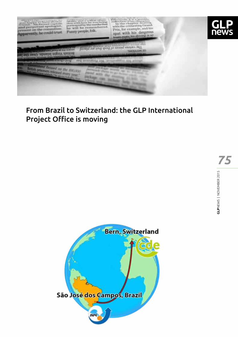
GL
PN
EWS
| N
OV
EMB
ER 2
01
5
75
NEWSAfter four years of being based at the National Institute for Space Research (INPE) in São José dos Campos, Brazil, the GLP International Project O┆ce is moving.
We are pleased to announce that from January 2016 onwards, the GLP-IPO will be hosted by the Centre for Development of Environment (CDE) in Bern, Switzerland. The CDE is an interdisciplinary research centre of the University of Bern, whose overarching goal is to produce and share knowledge for sustainable development in cooperation with partners in the global North and South. CDE concentrates its research on natural resource and ecosystem services, multidimensional disparities and governance of land and natural resources. It
has a strong focus on sustainability science in general and land system science in particular, works at multiple scales and maintains a wide partnership network in developing as well as in developed countries. The CDE has also a broad and long-standing experience in fostering dialogue between science and society and has contributed to land policy formulation and global forum development.
GLP looks forward in opening up exciting new opportunities, developments and perspectives for its 2016-2020 phase with the International Project O┆ce in Bern.
For more information about the CDE, please visit www.cde.unibe.ch
From Brazil to Switzerland: the GLP International Project O┆ce is moving
New
s
GL
PN
EWS
| N
OV
EMB
ER 2
01
5
76
New
sThe Global Land Project publishes synthesis and outlook paperIn a new paper the Global Land Project look back at the progress of Land System Science over the past 10 years of the programme and provides a perspective of the research directions and science priorities for the coming period. The paper is part of a special issue of the journal ‘The Anthropocene’ in which all IGBP core project re┅ect on their development.
During the past 10 years land system science has matured and moved from a focus on observing land change and elicitation of the underlying driving factors to a ┃eld that not only aims to understand complex
Ecology in an anthropogenic biosphereErle C. Ellis
Humans, unlike any other multicellular species in Earth�s history, have emerged as a global force that is transforming the ecology of an entire planet. It is no longer possible to understand, predict, or successfully manage ecological pattern, process, or change without understanding why and how humans reshape these over the long term. Here, a general causal theory is presented to explain why human societies gained the capacity to globally alter the patterns, processes, and dynamics of ecology and how these anthropogenic alterations unfold over time and space as societies themselves change over human generational time. Building on existing theories of ecosystem engineering, niche construction, inclusive inheritance, cultural evolution, ultrasociality, and social change, this theory of anthroecological change holds that sociocultural evolution of subsistence regimes based on ecosystem engineering, social specialization, and non-kin exchange, or �sociocultural niche construction,� is the main cause of both the long-term upscaling of human societies and their unprecedented transformation of the biosphere. Human sociocultural niche construction can explain, where classic ecological theory cannot, the sustained transformative e━ects of human societies on biogeography, ecological succession, ecosystem processes, and the ecological patterns and processes of landscapes, biomes, and the biosphere. Anthroecology theory generates empirically testable hypotheses on the forms and trajectories of long-term anthropogenic ecological change that have signi┃cant theoretical and practical implications across the subdisciplines of ecology and conservation. Though still at an early stage of development, anthroecology theory aligns with and integrates established theoretical frameworks including social�ecological systems, social metabolism, countryside biogeography, novel ecosystems, and anthromes. The “┅uxes of nature” are fast becoming “cultures of nature.” To investigate, understand, and address the ultimate causes of anthropogenic ecological change, not just the consequences, human sociocultural processes must become as much a part of ecological theory and practice as biological and geophysical processes are now. Strategies for achieving this goal and for advancing ecological science and conservation in an increasingly anthropogenic biosphere are presented. Full article is available at http://www.esajournals.org/doi/abs/10.1890/14-2274.1
socio-ecological systems dynamics but also provides guidance in the design and implementation of sustainability solutions, ranging from land governance to land system architecture for biodiversity conservation and ecosystem service provisioning.
An important part of the paper is dedicated to di━erent methods and tools applied to synthesize information across di━erent case studies and di━erent disciplines. Synthesis and perspective activities are core to the mandate of the Global Land Project.
The perspective provided on current research priorities is the basis of the new 10-year science plan of the Global Land Project.
Verburg et al., 2015. Land System Science and sustainable development of the earth system. A Global Land Project perspective. The Anthropocene. http://dx.doi.org/10.1016/j.ancene.2015.09.004
GL
PN
EWS
| N
OV
EMB
ER 2
01
5
77
Not
iceb
oard
Land System Science in Latin America: achievements and perspectivesInternational Seminar
Sébastien Boillat1 | Fabiano Micheletto Scarpa1
Introduction
Land system science has emerged as an integrative ┃eld of research that deals with the human use of land, its consequences, and the related socioeconomic, technological and organizational processes (Verburg et al. 2013). Since 2012, the GLP International Project O┆ce has been based at the Instituto Nacional de Pesquisas Espaciais (INPE) in São José dos Campos, Brazil. In this context, GLP took the opportunity to advance and promote land system science in Latin America.
Recent advances in Latin American land system science linked with GLP, are for example the study of land systems and the forest-agriculture interface, with emphasis in the Amazon region (de Espindola et al., 2012), modelling of land use change, biomass and related greenhouse gas emissions (Aguiar et al., 2007, 2012; Ometto et al., 2014), discussion about separation (�land sparing�) vs. integration (�land sharing�) models of speci┃c ecosystem functions and services (Grau et al., 2013) and distant market connections that drive land use changes (Bonilla-Moheno et al., 2014; Grau and Aide, 2008).
Land system research is evolving rapidly both in terms of scope, methods and theory with growing attention on the articulation of di━erent disciplines and research on linked outcomes of land resources, such as the nexus of food production, water, and energy. In this context, there is a need for Latin American research to engage and develop a regional perspective to emerging international research agendas and funding programs related to sustainability, global environmental and climate change, assuming cross-disciplinary collaboration, co-production of knowledge and stakeholder engagement, and using integrative cross-level methodologies.
Objectives
This seminar had the objective of gathering, synthesizing and conceptualizing existing advances in land systems science in Latin America, and of establishing perspectives of this research ┃eld for the region, building on the network developed around the GLP-IPO in Brazil. More speci┃cally, the seminar aimed at establishing the particularities of
the Latin American region that enables researchers to take a leading role in advancing speci┃c aspects of land system science. Can we speak about a �Latin American school� in land system research? What can the rest of the world learn from the Latin American particularities and experiences?
Three main research topics were discussed at the seminar which took place from 9th to 11th of November 2015 at the National Institute for Space Research - INPE in Brazil.
1) Land change monitoring and land-atmosphere キミデWヴ;Iピラミゲ キミ L;ピミ AマWヴキI;
In the last decades, there have been substantial advances in developing change monitoring systems in Brazil and Latin America, such as the PRODES project and DETER system developed by INPE (see Fearnside, 2015, this issue). These systems have gradually included models of the consequences of these changes, especially to address the relationship between land use change and greenhouse gas emissions. Thus, besides live monitoring of forest cover change, advances include the development of biomass and emission models (Aguiar et al., 2012) and the quanti┃cation of emission from tropical dam reservoirs (Fearnside and Pueyo, 2012). In this context, Latin American research institutions are increasingly producing their own datasets, analyses and knowledge corpus. What are the perspectives of these advances and their implications for global change research? More generally, how can uncertainties in knowledge of land-atmosphere interactions be tackled? What are the policy implications of both advancement and remaining uncertainties?
2) Social-ecological landscapes and land マ;ミ;ェWマWミデ ゲ┞ゲデWマゲ キミ L;ピミ AマWヴキI;
Latin American land users are characterized by their settlement history, and by strong social, political and economic power relations among and within groups (Brondizio, 2013; Killeen et al., 2008). Indigenous peoples, African-, European- and Asian-descent colonists, mestizo and mulato farmers, Andean colonists in the Amazon, planned and spontaneous settlements, have di━erent socio-cultural and socio-economic backgrounds, which shape their views, interests and relationships with the land. The social-ecological systems of Latin
1 Earth System Science Centre - CCST; National Institute for Space Research - INPE; São José dos Campos; São Paulo; BrazilE-mail: [email protected] / [email protected]; [email protected] / [email protected]
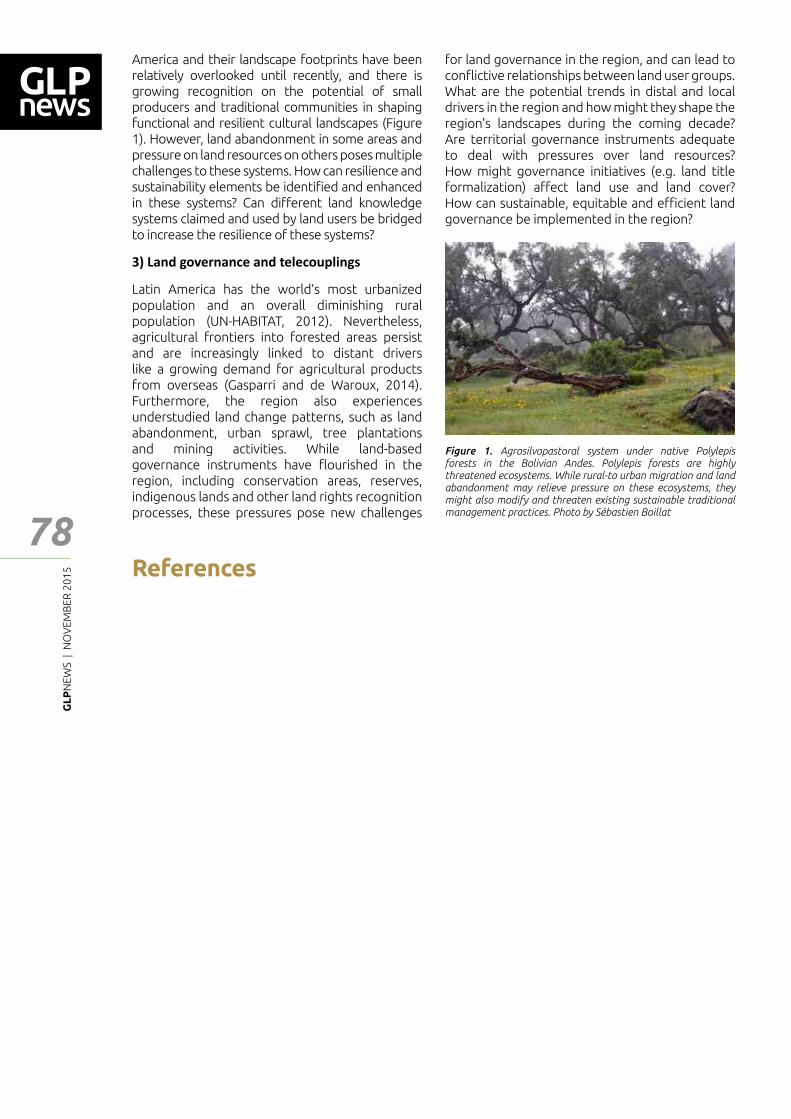
GL
PN
EWS
| N
OV
EMB
ER 2
01
5
78
Not
iceb
oard
America and their landscape footprints have been relatively overlooked until recently, and there is growing recognition on the potential of small producers and traditional communities in shaping functional and resilient cultural landscapes (Figure 1). However, land abandonment in some areas and pressure on land resources on others poses multiple challenges to these systems. How can resilience and sustainability elements be identi┃ed and enhanced in these systems? Can di━erent land knowledge systems claimed and used by land users be bridged to increase the resilience of these systems?
3) Land governance and telecouplings
Latin America has the world�s most urbanized population and an overall diminishing rural population (UN-HABITAT, 2012). Nevertheless, agricultural frontiers into forested areas persist and are increasingly linked to distant drivers like a growing demand for agricultural products from overseas (Gasparri and de Waroux, 2014). Furthermore, the region also experiences understudied land change patterns, such as land abandonment, urban sprawl, tree plantations and mining activities. While land-based governance instruments have ┅ourished in the region, including conservation areas, reserves, indigenous lands and other land rights recognition processes, these pressures pose new challenges
for land governance in the region, and can lead to con┅ictive relationships between land user groups. What are the potential trends in distal and local drivers in the region and how might they shape the region�s landscapes during the coming decade? Are territorial governance instruments adequate to deal with pressures over land resources? How might governance initiatives (e.g. land title formalization) a━ect land use and land cover? How can sustainable, equitable and e┆cient land governance be implemented in the region?
References
Aguiar, A.P.D., Câmara, G., and Escada, M.I.S. (2007). Spatial statistical analysis of land-use determinants in the Brazilian Amazonia: Exploring intra-regional heterogeneity. Ecological Modelling 209, 169�188.
Aguiar, A.P.D., Ometto, J.P., Nobre, C., Lapola, D.M., Almeida, C., Vieira, I.C., Soares, J.V., Alvala, R., Saatchi, S., Valeriano, D., et al. (2012). Modeling the spatial and temporal heterogeneity of deforestation-driven carbon emissions: the INPE-EM framework applied to the Brazilian Amazon. Glob Change Biol 18, 3346�3366.
Bonilla-Moheno, M., Grau, H.R., Aide, M., Álvarez-Berríos, N., and Babot, J. (2014). Globalization and land use in Latin America. GLP News 5�7.
Brondizio, E.S. (2013). A microcosm of the Anthropocene: Socioecological complexity and social theory in the Amazon. Perspectives: Journal de La Reseaux Francaise d�Institut D�études Avancées (RFIEA) 2013, 10�13.
de Espindola, G.M., de Aguiar, A.P.D., Pebesma, E., Câmara, G., and Fonseca, L. (2012). Agricultural land use dynamics in the Brazilian Amazon based on remote sensing and census data. Applied Geography 32, 240�252.
Fearnside, P.M. (2015). Natural riches of Amazonia, deforestation and its consequences. GLP News 22�25.
Fearnside, P.M., and Pueyo, S. (2012). Greenhouse-gas emissions from tropical dams. Nature Clim. Change 2, 382�384.
Gasparri, N.I., and de Waroux, Y. le P. (2014). The coupling of South American soybean and cattle production frontiers: new challenges for conservation policy and land change science. Conservation Letters n/a � n/a.
Grau, H.R., and Aide, M. (2008). Globalization and Land-Use Transitions in Latin America. Ecology and Society 13, 16.
Grau, R., Kuemmerle, T., and Macchi, L. (2013). Beyond �land sparing versus land sharing�: environmental heterogeneity, globalization and the balance between agricultural production and nature conservation. Current Opinion in Environmental Sustainability 5, 477�483.
Killeen, T.J., Guerra, A., Calzada, M., Correa, L., Calderon, V., Soria, L., Quezada, B., and Steiniger, M.K. (2008). Total Historical Land-Use Change in Eastern Bolivia: Who, Where, When, and How Much? Ecology and Society 13, 36.
Ometto, J., Aguiar, A., Assis, T., Soler, L., Valle, P., Tejada, G., Lapola, D., and Meir, P. (2014). Amazon forest biomass density maps: tackling the uncertainty in carbon emission estimates. Climatic Change 124, 545�560.
United Nations Human Settlements Programme (UN-HABITAT) (2012). State of the World�s Cities 2012/2013. Propserity of Cities (Nairobi).
Verburg, Peter H, Karl-Heinz Erb, Ole Mertz, and Giovana Espindola. 2013. �Land System Science: Between Global Challenges and Local Realities.� Current Opinion in Environmental Sustainability 5 (5): 433�37. doi:10.1016/j.cosust.2013.08.001.
Figure 1. Agrosilvopastoral system under native Polylepis forests in the Bolivian Andes. Polylepis forests are highly threatened ecosystems. While rural-to urban migration and land abandonment may relieve pressure on these ecosystems, they might also modify and threaten existing sustainable traditional management practices. Photo by Sébastien Boillat
GL
PN
EWS
| N
OV
EMB
ER 2
01
5
79
Ann
ounc
emen
tsPECS 2015 will gather scientists from various disciplines, from within and beyond the PECS network, to share cutting-edge research insights on social-ecological dynamics in the Anthropocene. The conference will engage and involve multiple stakeholders concerned with sustainable development and who are interested in developing new solutions and strategies. The conference is intended to highlight PECS achievements and ambitions, and to synthesize and integrate PECS-related research to provide a basis for a future social-ecological research agenda, especially in light of Future Earth.
F┌ヴデエWヴ キミaラヴマ;ピラミ I;ミ HW aラ┌ミS ;デぎ エ─ヮぎっっ┘┘┘くヮWIゲヲヰヱヵくラヴェっ
“Land system science: understanding realities and developing solutions”The upcoming third OSM 2016 will be organized by the Chinese Academy of Agricultural Sciences under the coordination of Scienti┃c Steering Committee (SSC) and International Project O┆ce (IPO) of GLP. The aim of GLP 3rd OSM 2016 is to bring together large parts of the international research community working on land system issues, showcase the width and scope of ongoing research, help build a community in this highly interdisciplinary ┃eld, inspire new research and facilitate review, theory building and extrapolation. The conference covers the following main themes:
- Land systems in an urbanizing and telecoupling world
- Land systems and the water, food, energy nexus
- Managing trade-o━s and synergies for sustainable land systems
- Novel land governance systems to manage natural resources
Special GLP awards such as best student poster/oral presentation awards, GLP awards, will be launched amid the GLP OSM 2016. It is planned to organize a few special issues based on the sessions and full papers submitted to the GLP OSM.
Conference website: http://www.glp-osm2016.com/
Call for sessions deadline: 20th December 2015
GL
PN
EWS
| N
OV
EMB
ER 2
01
5
80
Ann
ounc
emen
ts
Earth�s land surface embodies the dynamic interplay of the physical, social and economic processes that constitute global change. For example, deforestation, agriculture and urbanisation all modify the climate, ecosystems and biogeochemical cycles. Such changes, in turn, a━ect land and the societies that rely on it. Because land is shaped today largely by human activities, it has become an important site of policies aimed at achieving sustainability. Consequently, land is also the site of con┅icts and competing claims: land grabs and the competition between crops for food and biofuels are but two manifestations.
Major advances in quantitative global reconstruction of prehistoric land use and land cover changes are required to understand the role of early land use in transforming Earth system processes. Adequate incorporation of anthropogenic land use and land cover change in global and regional climate models remains one of the major priorities in climate modelling. Early land use and land cover scenarios show very large di━erences; improved global historical reconstructions are essential to advancing
This session aims to bring together a diverse group of natural and social scientists to explore emerging perspectives on land. We welcome contributions on topics including but not limited to: 1) drivers, trajectories and implications of historic and future land-use change; 2) trade and teleconnections; 3) novel land-use practices for responding to rapid global change; 4) land-atmosphere-hydrosphere interactions.
Earth system science and e━orts to date the emergence of the Anthropocene. Further, ecological science and conservation are in need of more robust empirical baselines for the timing of human alterations. This session encourages contributions from paleo-ecologists, historians, archaeologists and modellers towards the goal of accelerating collaborative interdisciplinary knowledge generation to fully describe the global history of anthropogenic land use and land cover change from its ┃rst beginnings.
GLP Session: Emerging perspectives on land in a changing world
GLP and PAGES session: Dating the Anthropo-cene: Early Land Use and Earth System Change
Get involvedJoin the Network
To join the GLP Network and receive the GLP e-News and the GLP NEWS, please subscribe at: [email protected]
Call for contributions � next GLP NewsGLP IPO is now accepting contributions to the next issue of GLP NEWS. If you would like to contribute, please, contact the IPO by e-mail: [email protected]
Call for announcements in GLP e-News and WebsiteWe are open to announce events and publications related to GLP science on our monthly GLP e-news or on GLP website. If you want to contribute, please contact us sending an email to: [email protected]
Have your project endorsed by GLP and included in the GLP WebsiteTo have your project endorsed by GLP, please, look at the 'Getting Involved' section in our website (www.globallandproject.org) to application guidelines.
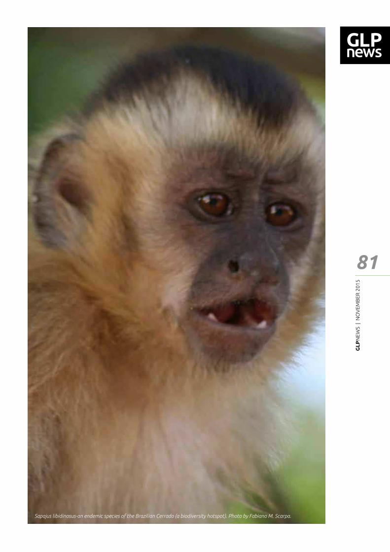
GL
PN
EWS
| N
OV
EMB
ER 2
01
5
81
Sapajus libidinosus-an endemic species of the Brazilian Cerrado (a biodiversity hotspot). Photo by Fabiano M. Scarpa.
GL
PN
EWS
| N
OV
EMB
ER 2
01
5
82
Ann
ounc
emen
ts
GLP International Project O┆ceNational Institute for Space Research- INPE Earth System Science Centre- CCST
Av. dos Astronautas, 1758 Earth System Science Center (CCST), 1st ┅oor, room 22 Jd. Granja - 12227-010 São José dos Campos - São Paulo - Brazil Fone: +55 12-3208 7931/7942
www.globallandproject.org
GLP International Project O┆ce is thankful for the ┃nancial support from the National Institute for Space Research – INPE, Brazil, The Earth System Science Center (CCST) and The International Geosphere-Biosphere Programme (IGBP).
Graphic design: Luciano Urizzi, Magno Studio, Brazil
GLP is a joint research project of the International Geosphere-Biosphere Programme (IGBP) and Future Earth.