Embed Size (px)
Citation preview

SIBLEY VOLCANIC REGIONAL PRESERVEEXPLORATION
http://www.kqed.org/quest/exploration/sibley-volcanic-regional-preserve-explorationDifficulty: Moderate, Accessibile: No, Duration: 2.2 hrs
Sibley Volcanic Regional PreserveThis Exploration created in collaboration with the
As sure as the earth moves in Oakland, there's a volcano just offSkyline Boulevard. Not just any volcano, mind you. This one's lying on its side with its guts exposed. You might not recognize it right away, owingto its reclining position and the grassy coat it's adopted. But among the shrubs and grasses at Sibley Volcanic Regional Preserve, you'll find therocky body and underpinnings of one of the largest of a handful of volcanoes that once dotted our geologic neighborhood. Join us and naturalistSteve Edwards of the East Bay Regional Park District on our latest Bay Area science hike.
Location
6800 Skyline Blvd, Oakland, CA 94611 (Map)Phone: 888-EBPARKS (888-327-2757), option 3, extension 4554
Open between 5 a.m. and 10 p.m. unless otherwise posted or permitted
Download a trail map and more about the park.
Special thanks to Steve Edwards, Isa Polt-Jones and Rosemary Cameron of the East Bay Regional Parks District for their participation.Robin Marks contributed to this Exploration.
Page 1 of 11 http://www.kqed.org/quest/exploration/sibley-volcanic-regional-preserve-exploration

Marker 1 latitude 37.8503461 longitude -122.1956934
1a. Soil layers in the hillsides
Bands of green and brown on thehillsides near Sibley reveal layersof soils created by differentgeologic processes. Greenergrass means clay-like soils thathold moisture. Water drains outfaster from gravely soils, leavingthe grass brown.
1b. How to make a volcano
Our guide, Steve Edwards,demonstrates how California'svolcanoes came to be. When twoof the earth's tectonic platescollide, the heavier one will sinkunder the other. As the heavierplate moves toward the hot coreof the earth, minerals in it meltand become magma. This heatedmagma, less dense than the solidrock around it, forces its way tothe surface, sometimesexplosively.
Page 2 of 11 http://www.kqed.org/quest/exploration/sibley-volcanic-regional-preserve-exploration

Marker 2 latitude 37.8500602 longitude -122.1953522
2a. Lava feeder
Sibley's central geologic feature isits volcano, Round Top. Overmillions of years, the movementsof tectonic plates have pushedRound Top over onto its side. Inthis spot, you are standing in whatwas the interior of the volcano.This black lava flowed up througha crack in the earth's crust, to fillRound Top's crater.
2c. Mysterious marker
A man-made plum in the brecciapudding. Anyone have any ideawhat this is, or why it has beenattached to this rock?
2b. Plums in the pudding
This plums-in-the-puddingformation is called breccia(pronounced BREH-chuh). It's theresult of lava erupting from avolcanic vent, dragging with itchunks of rock it passes on theway. Hot lava coming up throughRound Top broke itself up whilesolidifying, and ripped pieces oflighter-colored sandstone andbluish schist off ancient rocksthousands of feet below thesurface as it made its wayupward.
2d. Cutting corners
This rounded hump of rock is avictim of weathering. Imagine ablock of volcanic rock, shrinkingas it cools, forming cracks.Between those cracks are roughlycubic blocks of lava. Theirexposed corners weather fasterthan the rest of the rock, leavingbehind spherical blobs with layerspeeling like onion skins.
2e. Onion skin layers
Onion skin layers in theweathering rock, close up.
2f. Lava lake
This flow once formed a lake oflava that congealed inside RoundTop's vent. Erupting magma hadto go up through this lake, oralong side of it and erupt out ofthe side of the mountain.
Page 3 of 11 http://www.kqed.org/quest/exploration/sibley-volcanic-regional-preserve-exploration
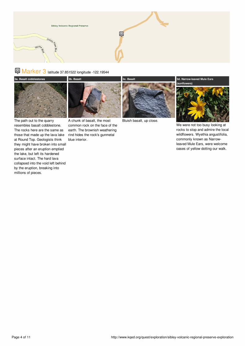
Marker 3 latitude 37.851522 longitude -122.19544
3a. Basalt cobblestones
The path out to the quarryresembles basalt cobblestone.The rocks here are the same asthose that made up the lava lakeat Round Top. Geologists thinkthey might have broken into smallpieces after an eruption emptiedthe lake, but left its hardenedsurface intact. The hard lavacollapsed into the void left behindby the eruption, breaking intomillions of pieces.
3b. Basalt
A chunk of basalt, the mostcommon rock on the face of theearth. The brownish weatheringrind hides the rock's gunmetalblue interior.
3c. Basalt
Bluish basalt, up close.
3d. Narrow-leaved Mule Ears(sunflowers)
We were not too busy looking atrocks to stop and admire the localwildflowers. Wyethia angustifolia,commonly known as Narrow-leaved Mule Ears, were welcomeoases of yellow dotting our walk.
Page 4 of 11 http://www.kqed.org/quest/exploration/sibley-volcanic-regional-preserve-exploration

Marker 4 latitude 37.852651 longitude -122.190703
4a. The Quarry
Sibley's volcano, pushed over onits side, has had a second life asa quarry dug by Kaiser Sand andGravel. The quarry, which cutthrough the interior of the top partof the volcano, provided basaltused in making roads.
4b. Standing in the volcano
Ranger Steve Edwards pointsacross Round Top's crater, nowtipped on its side, to Mt. Diablo inthe distance. "That's not avolcano," he says, noting thatmany people think it might bebecause of its shape. "Here inSibley, we're standing in thevolcano."
4c. Crater tipping
Steve demonstrates the volcano'sposition in the past, and now. Hishand is the volcano's caldera, thedepression left in the top of avolcano after an eruption. Here,it's upright, as it was millions ofyears ago when Round Top wasactive.
4d. Crater tipping
The action begins; as tectonicplates in northern California slidepast each other, the forces oftheir movements tilt the volcano.
4e. Sibley's Round Top volcano tipped
Sibley's Round Top volcano as it'spositioned now, tipped onto itsside.
4f. Quarry Mazes
Over the years, several mazeshave been made at the bottom ofthe quarry, and are regulardestinations for park visitors.
4g. The cliffs of Sibley
Watch your step and don't gobeyond the fences or you mayend up part of the quarry!
Page 5 of 11 http://www.kqed.org/quest/exploration/sibley-volcanic-regional-preserve-exploration

Marker 5 latitude 37.857089 longitude -122.197497
5a. Bake zone
The red part of this basalt outcropis called a bake zone. The basaltlava on the left may have stillbeen hot and steaming when thelighter volcanic ash on its rightlanded on it. The steam comingfrom the basalt may have turnedthe lighter volcanic ash red.
5b. Bake zone
Bake zones can contain somedramatic features. After a rain,these red rock formations turnblood-red. The red results fromoxidation of iron.
Page 6 of 11 http://www.kqed.org/quest/exploration/sibley-volcanic-regional-preserve-exploration

Marker 6 latitude 37.856713 longitude -122.195254
6a. North quarry pit
You're looking northerly at anotherquarry pit left by Kaiser, exposinglayered basalt lava.
6b. Cooling Layers
in a close up of the wall of thequarry, we see layers of basaltlava, nearly perpendicular to theoriginal flow. These layers werecaused by jointing as the lavacooled and shrank.
Page 7 of 11 http://www.kqed.org/quest/exploration/sibley-volcanic-regional-preserve-exploration

Marker 7 latitude 37.8575 longitude -122.197778
7a. Steamy lava holes
Holes, or vesicles, lend a swiss-cheese texture to some of thelava. These pockets were formedwhen water in the lava escapedas steam while lava was cooling.
7b. Vesicles filled with minerals
Over time, many of the pockets inthe rock were filled with mineralsprecipitated from ground water orvolcanic fluids. The green fillingsshown here are celadonite, amineral related to micas.
7c. Vesicles filled with minerals
The mineral-filled pockets have acharacteristic almond shape thatindicates which direction the lavawas flowing. The thinner, pointyend leads in the direction awayfrom the volcano. The white rockis opal or chalcedony.
7d. Rhyolite
This yellowish rock, calledrhyolite, is also a volcanic rock.But Round Top didn't contain thematerial this rhyolite is made of.Four miles north of Sibley isanother vent that spewed forthrhyolite, about 9.8 million yearsago. At that time, it was eruptingbeside Round Top. Fault motionsubsequently moved it north toBerkeley.
Page 8 of 11 http://www.kqed.org/quest/exploration/sibley-volcanic-regional-preserve-exploration

Marker 8 latitude 37.859167 longitude -122.199444
8a. Basalt flow
This basalt flow, about 150 feetthick, stretches all the way toHighway 24 east of the CaldicottTunnel on Highway 24. Unlike thelavas in Hawaii, Round Top'sflows were thick and slow-moving, advancing about as fastas leisurely walk.
8b. Wall of lava
Like the volcano it came from,this lava flow has been tilted ontoits side, and its current positionhelps us imagine the flow as itslowly marched across thelandscape. Such creeping lavawould have set all the land aroundit on fire, sending blocks of hotlava tumbling off of it, andconsuming everything in its path--including intrepid rangers andreporters.
Page 9 of 11 http://www.kqed.org/quest/exploration/sibley-volcanic-regional-preserve-exploration

Marker 9 latitude 37.859722 longitude -122.199722
9a. Welded cinder
These textured red blobs are arare formation called weldedcinder. They were formed whenbasalt exploded out of Round Topin small hot, fragments thatlanded on each other and stucktogether. Their "real" name alsooffers a good example ofgeologist jargon: rocks stucktogether are "agglutinated," if thepieces stuck together are pebblesized, they're "lappili," and ifthose pebble-sized pieces arerounded, it's an "agglomerate."
9b. Welded cinder
Behold: a close-up of the rare andbeautiful agglutinated lappiliagglomerate. Or maybe let's stickwith the name "welded cinder."
9c. Quartz vein in rock
Interesting quartz vein. Or is itcalcite...
Page 10 of 11 http://www.kqed.org/quest/exploration/sibley-volcanic-regional-preserve-exploration

Marker 10 latitude 37.860278 longitude -122.200278
10a. Petroglyph?
Ranger Steve points to a spiralpecked into a stone that juts outfrom a ridge top.
10b. Profanoglyph
Alas, our guide tells us, uponcloser inspection, it's clearly beenchipped out with a steel chisel.So, unlike a petroglyph, which issacred, this carving is declared a"profanoglyph."
Page 11 of 11 http://www.kqed.org/quest/exploration/sibley-volcanic-regional-preserve-exploration