Embed Size (px)
Citation preview

Oil & Natural Gas Corporation Ltd, Vadodara
Email: [email protected]
10th Biennial International Conference & Exposition
P 157
Exploration Potential of Syn-rift Olpad Play in the western rising flank of
Warosan low, Mehsana Tectonic Block, North Cambay Basin.
Varughese C. M.*, Das N.C., Arya O. P., Kumar Anil & Singh A. K.
Summary
Mehsana area of North Cambay Basin has got well established oil fields which are producing for last four decades from
multiple plays at different stratigrapic levels from Older Cambay shale to Kalol. The basin is in a very mature state of
exploration and of late it is observed that though the success rate is good but sizes of the discoveries are small. Hence there
is need to shift focus of exploration to deeper plays below Older Cambay Shale (OCS) and in this respect exploration of Syn-
rift Olpad Formation is important. The encouraging result from recently drilled exploratory well in the eastern basin margin
in the North-Mansa area, which is producing oil from Olpad on self at a sustained rate of 190 barrels/day with no drop in
reservoir pressure, has rejuvenated the pursuit for hydrocarbons in the synrift sediments in north Cambay Basin. The present
study is an effort assimilate this success and to look for similar setup in other parts of the Mehsana area. The eastern margin
success of Olpad has occurred in a set up where the Cambay shale, which is the proven Source rock, is in juxtaposition with
Olpad Formation. The authors are of the view that similar setup exists in the western rising flank of Warosan low also.
Keywords: North Cambay Basin
Introduction
Cambay Basin is a narrow elongated (NNW - SSE)
extensional basin located on the western margin of Indian
plate (Fig. 1). Precambrian rocks of Aravalli System are
exposed in the northeast. Deccan Trap of late Cretaceous
to early Tertiary age with underlying Mesozoic strata is
exposed on the eastern and western flanks of the basin.
This Cenozoic extensional basin is a typical “intra cratonic
aborted rift” which evolved due to rifting along
Dharwarian orogenic trend during the northward migration
of the Indian plate after its break up from Gondwanaland
in Late Mesozoic and the Basin came into existence during
Early Cretaceous. The rift-drift transition phase of Indian
plate witnessed volcanic events in the western India during
which huge thickness of traps are deposited in Cambay
Basin.
The extensional architecture of the basin is defined by two
types of faults viz., 'listric normal faults', striking N-S to
NNW-SSE and 'transfer faults', trending ENE-WSW to
NE-SW. The listric faults mostly run sub parallel to the rift
- border faults. Transfer faults frequently offset the listric
faults. During Late Miocene, few areas in the basin
experienced inversion tectonics related to Himalayan
Orogeny. Thus basin architecture is defined by an
enechelon arrangement of asymmetric half grabens
Fig.1 Geological map showing Cambay Basin

2
bordered by listric normal faults oblique to the rift axis and
are separated by transfer fault zones/accommodation zones
and basement highs. A thick sequence of sedimentary
rocks ranging in the age from Paleocene to Recent overlies
the Deccan Trap, which is considered as technical
basement in Cambay Basin. A total of about 6 km thick
sedimentary sequence is expected in the deepest part of the
Cambay Basin. A complex network of these faults
compartmentalizes the basin into distinct
tectonosedimentary blocks bordered by major transfer
faults (Fig 2). Based on major basement faults the Cambay
Basin is subdivided into five major tectonic blocks, which
Fig.2 Tectonic map of Cambay Basin.
have been named from south to north Viz. (I) Narmada-
Tapti Block, (II) Jambusar-Broach Block (III) Tarapur-
Cambay Block (IV) Mehsana-Ahmedabad Block and (V),
SanchorPatan Block. The first two blocks informally
comprise South Cambay Basin and last three blocks are
North Cambay Basin separated by Mahi River. The present
study is from northern part of Mehsana- Ahmedabad
Block. Exploration in North Cambay Basin hitherto was
mostly confined to lower Eocene synrift to post rift plays
pertaining to Older Cambay shale, Younger Cambay shale
(Kadi & Kalol formations). The exploratory efforts so far
were based on structural elements and have met with
considerable success in finding hydrocarbons from
multiple stratigrahic levels (Fig.3). The major oil fields
(Fig.4) in this area are Lanwa-Santhal-Balol producing
exclusively from Kalol Formation. Jotana, North-Kadi,
Sobhasan, Linch and Nandasan produce from multiple
plays ranging from Older Cambay shale to Kadi and Kalol
Formations. Exploration has reached a mature stage and
at present it is focused on subtle traps and small amplitude
entrapment situations in the areas bordering established
fields.
Huge thicknesses of Paleocene synrift sediments (Olpads)
in Mehsana area of Cambay Basin has escaped focused
Fig.3 Generalized Stratigraphy of Cambay Basin.
exploration over the years due to the successes from
younger plays. Though Small oil pools in Olpad are
already established on Khambel-Kamboi and West Patan
area to the west of Mehsana Horst, success was so far
elusive in the eastern depression and eastern margin.
Fig.4 TWT Relief Map on horizon within Younger Cambay
Shale.

3
Reservoir characteristics & Play types
In the early stages of rift the primodial lineaments
reactivated; subsequent rift & drift lead to creation of
undulating Basin floors with highs and Lows providing
depocentres for huge thickness of sediments i.e, Olpads
derived from erosion of Deccan traps.
The commom lithofacies of Olpad comprises trap
conglomerate with pebbles of varying sizes (Fig.5), trap
wacke, trap wash, siltstone & claystones. Trap
conglomerates and trap wacke differ in size of pebbles and
trap fragments generally embedded in clayey matrix. The
finer volcanic particles known as trap-wash (Fig.6)
comprise clay and siltstones. Claystones are often
laminated, varying in colour from dark grey, blackish grey
to red. Thinly bedded crypto crystalline dirty white layers
are also reported from Olpad Formation suggestive of
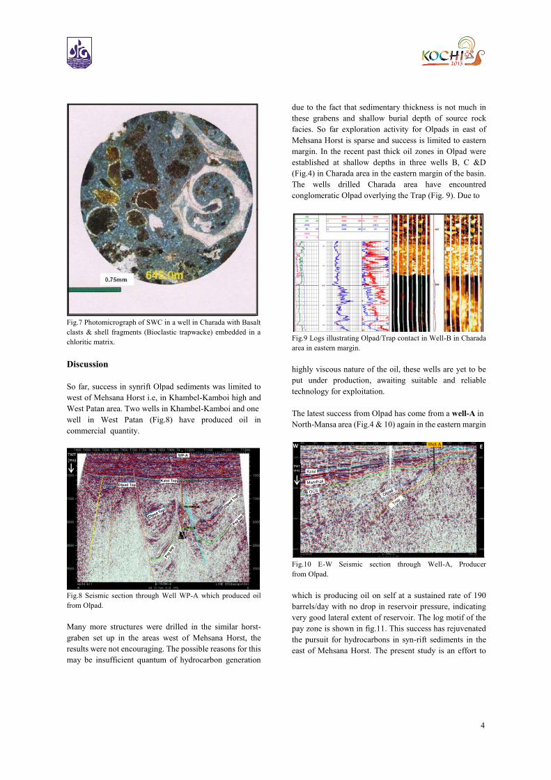
deposition under low energy conditions. Bioclastic
trapwacke comprising sub rounded basalt clasts along with
shell fragments embedded in chloritic matrix (fig.7)
suggestive of fluvial/lacustrine condition are reported in
wells in Charada area in eastern margin.
Olpad play can be broadly divided into two major
categories based on their occurrences and genetics; A.
Sediments on Basin margin, structural highs and their
flanks in narrow half grabens. B. Rift fills sediments in
depressions. Olpads on Basin margin, on Horsts blocks and
its flanks can be explained by insitu weathering
and leaching of traps and transport of these huge
volumes by alluvial fans towards nearest depocentres
/depressions.
The resultant deposits exhibit the occurrence trap
conglomerates gritty sands at proximal part of alluvial
fans, trapwacke on the crest and immediate slopes and
finally grading into trapwash comprising clays, siltstone
facies further downward in depression. Major depressions
both west and east of Mehsana Horst has accommodated
huge thickness of Olapd sediments as they became more
pronounced with rifting till major marine transgression
during which Older Cambay shale was deposited in the
entire Basin. In the depressions however these Olpad
sediments might have been affected by axial drainage
resulting in development of good reservoir facies at places.
Fig.5 FMI showing Trap conglomerate with gravel/pebbles of
different sizes in Olpad Formation in Charada area.
Fig.6 FMI showing interbedding of Trapwash & Trapwacke in
Olpad Formation in Charada area.
4
Fig.7 Photomicrograph of SWC in a well in Charada with Basalt
clasts & shell fragments (Bioclastic trapwacke) embedded in a
chloritic matrix.
Discussion
So far, success in synrift Olpad sediments was limited to
west of Mehsana Horst i.e, in Khambel-Kamboi high and
West Patan area. Two wells in Khambel-Kamboi and one
well in West Patan (Fig.8) have produced oil in
commercial quantity.
Fig.8 Seismic section through Well WP-A which produced oil
from Olpad.
Many more structures were drilled in the similar horst-
graben set up in the areas west of Mehsana Horst, the
results were not encouraging. The possible reasons for this
may be insufficient quantum of hydrocarbon generation
due to the fact that sedimentary thickness is not much in
these grabens and shallow burial depth of source rock
facies. So far exploration activity for Olpads in east of
Mehsana Horst is sparse and success is limited to eastern
margin. In the recent past thick oil zones in Olpad were
established at shallow depths in three wells B, C &D
(Fig.4) in Charada area in the eastern margin of the basin.
The wells drilled Charada area have encountred
conglomeratic Olpad overlying the Trap (Fig. 9). Due to
Fig.9 Logs illustrating Olpad/Trap contact in Well-B in Charada
area in eastern margin.
highly viscous nature of the oil, these wells are yet to be
put under production, awaiting suitable and reliable
technology for exploitation.
The latest success from Olpad has come from a well-A in
North-Mansa area (Fig.4 & 10) again in the eastern margin
Fig.10 E-W Seismic section through Well-A, Producer
from Olpad.
which is producing oil on self at a sustained rate of 190
barrels/day with no drop in reservoir pressure, indicating
very good lateral extent of reservoir. The log motif of the
pay zone is shown in fig.11. This success has rejuvenated
the pursuit for hydrocarbons in syn-rift sediments in the
east of Mehsana Horst. The present study is an effort to

5
assimilate this success and to look for similar setup in
western rising flank of Warosan Low. We can understand
from the regional relief map (Fig.4) of the reflector within
younger cambay shale (Mandhali) that Warosan Low is
actually the northern extension of Nardipur Low. The
rising flanks of this composite Warosan-Nardipur Low is
important because of the fact that this depression has got
huge thickness of cambay shale, which is the established
source rock in the north Cambay Basin and we have major oil fields producing from shallower Formations. Unlike the
areas falling in the west of Mehsana Horst, this low might
have generated enoromous amount of hydrocarbon to
charge the reservoirs at multiple stratigraphic plays in the
east of Mehsana Horst area. Jotana Fault (Fig 4 & 12) with
significant throw is a prominent listric Fault east of
Mehasan Horst.
Fig.11 Composite log motif & processed log of Olpad pay zone
of a Well-A in North Mansa area.
Fig.12 Coherency slice at 1100 ms clearly brings out
Jotana fault.
Thickness of sediment layers/Formations gradually
increases eastward towards Warosan depression. At all
stratigraphic level, the sedimentary layers forms anticlinal
structure along the downthrown side of the Jotana fault due
to drag effect.
Fig.13 Regional E-W Seismic transect connecting Jotana field and Well-A of Mansa Field.

6
All along the length of this fault hydrocarbon
accumulations in OCS, Mandhali, Mehsana & Kalol have
been established and currently being exploited in Jotana
field, adjoining western rising flank of Warosan Low &
northern part of Linch field.
As discussed earlier, Mehsana Horst being the prominent
structural element, uplifted to considerable height during
rifting stage must have contributed enormous amount of
trap derived sediments/Olpads during upheavals to the
west as well into Warosan depression in the east. Jotana
Fault being the nearest major listric fault to the east of
Mehsana Horst, thick sequence of Olpads in the form of
trap conglomerate, trap wacke are likely to be encountered
in the western rising flank of Warosan Low and forming
entrapment against this major fault as well as in the up
thrown block bordering eastern flank of Mehsana Horst
where Olpad is in juxtaposition with Cambay shale which
is the established source rock. In the similar set up oil has
been encountered in well A which is evident in seismic
section (Fig. 10). It can also be seen from the seismic
transect (Fig.13) that similar setup do exists in the western
rising flank of Waosan low. It is well established fact that
Jotana main fault is providing the entrapment condition at
multiple younger stratigraphic levels. Till now the
exploration success along this fault was mainly from post
rift sequences. No well has penetrated Olpad Formation in
the immediate downthrown side of this major fault. Few
wells were drilled up to Olpad in the up thrown block of
this fault. Well E drilled in northern part of Linch field has
encountered good reservoir facies in Olpad. Well-F in
Santhal field in up thown side of Jotana fault has been
tested in Olpad and gave indications of of oil. Western
rising flank of Warosan depression where Olpad
Formation is in juxtaposition with Older Cambay shale is
likely to be the ideal locale for hydrocarbon accumulation.
Further eastward, towards basinal axis Olpad Formation is
likely to be dominated by trapwash and finer clastics being
away from source. Well-G was drilled to a depth of 5006m
in the above settings and encountered about 2000m of
Olpad sequence, however the reservoir facies were poor.
Introspection
In the available seismic data, resolution of deeper events
are very poor and are also masked by first orders multiples
of Kalol formation, hence impression of Jotana fault is not
very clear in the deeper section. Energy penetration beyond
Kadi formation is a problem in the area due to presence of
thick coal in Kalol and Kadi formations. Hence getting
proper seismic expression from Olpad formation which is
expected beyond a depth of about 2700 mts is a challenge
and recent efforts to acquire data by focusing this objective
was not very successful. Special reprocessing with focus
to enhance the deeper events may help in interpretation. It
can be concluded that the recent success in Olpad
Formation in the eastern margin, can be replicated in the
western rising flank of Nardipur-Warosan low also where
we find Cambay shale is in juxtaposition with Olpad. In
this part there is added advantage of the presence of major
Jotana fault which offers a proved entrapment situation.
Here the Olpad reservoirs is expected at a deeper depth in
comparison to eastern margin, hence quality of the oil
should be better.
Conclusion
Mosaic of en-echelon half grabens and grabens acted as
depocentres during early synrift stage in north Cambay
Basin. Synrift sediments of Olpad Formation comprising
trap conglomerate, trap wacke, trap wash, siltstone &
claystone derived from weathering and leaching of Deccan
Traps were deposited in fluvial and lacustrine
environment. Warosan-Nardipur Low, the prominent
depression in the Mehsana area received enormous
thickness of synrift sediments from west as well as from
eastern Basin margin. Significant hydrocarbon finds in
Olpad sediment in the eastern margin in Charada & Mansa
area led us to believe that areas in the western rising flank
of Warosan depression, in proximity to Mehsana horst are
ideal locale for exploration of Olpads
Acknowledements
The authors are thankful to the ONGC management for
granting permission to publish the paper and use the data
and the findings of various projects. We are also grateful
to Mr. S. K. Das ED-Basin Manager, Western Onshore
Basin, ONGC, Vadodara for the guidance and
encouragement. The views expressed in the paper are
solely of the authors and not necessarily of the organization
in which they are working.
References
Lithostratigraphy of Indian Petroliferous Basins, by
J.Pandey etal; ONGC,1993;unpublished report
Identification of Prefered Reservoir Development In Olpad
Formation For The Exploration Of Deeper Prospects

7
Broach Block, Cambay Basin by S. Mayor1, S.S. Sawkar2
etal, 5th Conference & Exposition on Petroleum
Geophysics, Hyderabad-2004, India PP 388-395
Insights on Olpad Formation: -Assessment of
Hydrocarbon Play Types in North Cambay Basin, India by
V.Pratap and S.C.Sonare, 6th Conference & Exposition on
Petroleum Geophysics, Kolkota-2006, India
Developing a suitable methodology for the evaluation of
payzones for effective reservoir characterization of Olpad
in Charada-Mansa area in Cambay Basin by B.K.Saikia,
Rajesh Chandra , CEWELL. ONGC, June, 2010;
unpublished report