Embed Size (px)
Citation preview
111
Exploiting Multi-modal Contextual Sensing for City-bus’sStay Location Characterization: Towards Sub-60 SecondsAccurate Arrival Time Prediction
RATNA MANDAL∗, Institute of Engineering & Management, Kolkata, IndiaPRASENJIT KARMAKAR∗, ACM Member, IndiaSOUMYAJIT CHATTERJEE∗, Indian Institute of Technology Kharagpur, IndiaDEBALEEN DAS SPANDAN, BCET Durgapur, IndiaSHOUVIT PRADHAN, BCET Durgapur, IndiaSUJOY SAHA, National Institute of Technology Durgapur, IndiaSANDIP CHAKRABORTY, Indian Institute of Technology Kharagpur, IndiaSUBRATA NANDI, National Institute of Technology Durgapur, India
Intelligent city transportation systems are one of the core infrastructures of a smart city. The true ingenuityof such an infrastructure lies in providing the commuters with real-time information about citywide trans-ports like public buses, allowing her (him) to pre-plan the travel. However, providing prior information fortransportation systems like public buses in real-time is inherently challenging because of the diverse nature ofdifferent stay-locations that a public bus stops. Although straightforward factors stay duration, extracted fromunimodal sources like GPS, at these locations look erratic, a thorough analysis of public bus GPS trails for720km of bus-travels at the city of Durgapur, a semi-urban city in India, reveals that several other fine-grainedcontextual features can characterize these locations accurately. Accordingly, we develop BuStop, a system forextracting and characterizing the stay locations from multi-modal sensing using commuters’ smartphones.Using this multi-modal information BuStop extracts a set of granular contextual features that allow the systemto differentiate among the different stay-location types. A thorough analysis of BuStop using the collectedin-house dataset indicates that the system works with high accuracy in identifying different stay locations likeregular bus-stops, random ad-hoc stops, stops due to traffic congestion stops at traffic signals, and stops atsharp turns. Additionally, we also develop a proof-of-concept setup on top of BuStop to analyze the potentialof the framework in predicting expected arrival time, a critical piece of information required to pre-plan travel,at any given bus-stop. Subsequent analysis of the PoC framework, through simulation over the test dataset,shows that characterizing the stay-locations indeed helps make more accurate arrival time predictions withdeviations less than 60 seconds from the ground-truth arrival time.
CCS Concepts: • Human-centered computing→ Smartphones; Ubiquitous computing.
Additional Key Words and Phrases: intelligent transportation, multi-modal sensing, smartphone computing,stay-location detection, machine learning
1 INTRODUCTIONIntelligent public transportation has been one of the primary goals behind the development ofsmart-city infrastructure. Various smartphone-based apps are widely used throughout multiplecities worldwide to assist commuters with the public city-transportation system. An October 2016survey report by the California Department of Transportation has indicated that people preferred∗All three authors contributed equally to this research.
Authors’ addresses: Ratna Mandal, [email protected], Institute of Engineering & Management, Kolkata, India;Prasenjit Karmakar, [email protected], ACM Member, India; Soumyajit Chatterjee, Indian Institute ofTechnology Kharagpur, India, [email protected]; Debaleen Das Spandan, BCET Durgapur, India, [email protected]; Shouvit Pradhan, BCET Durgapur, India, [email protected]; Sujoy Saha, National Institute of Technology Durgapur,India, [email protected]; Sandip Chakraborty, Indian Institute of Technology Kharagpur, India, [email protected]; Subrata Nandi, National Institute of Technology Durgapur, India, [email protected].
arX
iv:2
105.
1313
1v1
[cs
.LG
] 2
4 M
ay 2
021
111:2 Mandal, et al.
to use public transportation rather than driving while using multi-modal transit planning apps ontheir smartphones, albeit the United States is predominantly a car-dependent society [33]. Suchan advantage comes from utilizing real-time information captured through on-vehicle sensorsand Internet-of-Thing (IoT) devices deployed on the vehicles, as well as sharing the commuters’information through smartphone-based apps. However, many-a-times, such systems’ accuracy getshampered, primarily because of various on-road dynamics, like traffic congestion near a marketand its domino effect on different interconnecting roads. Although real-time information can helpthe commuters know the bus’s current position on which she has planned to board, it certainlyaffects her travel planning and time management. As shown in [7], commuters do not prefer tospend time outside, waiting for an incoming bus. Therefore, there is a need for an accurate trackingsystem for city transportation systems.Traditionally, tracking and localization of vehicles have highly relied on GPS and cellular net-
works [39]. However, although such unimodal sensing can provide information about the locationand state of mobility, i.e., whether moving or stopped, they do not reveal the true nature of thestay-location or, in general, why the vehicle has stopped. This, in turn, has a huge impact on thefinal information of the expected arrival time required to pre-plan a trip. This problem furtherintensifies for city transportation systems like public buses, which stop at many points than pri-vate or shared cabs. Interestingly, some of the existing works [13, 24] have tried to explore thisproblem of characterizing different stay-locations for clearer insight on mobility patterns of citytransportation systems like public-buses. Fei et. al. [13] have analyzed speed patterns around a busstop location to have a clear insight of traffic congestion or road illumination as random eventsalong the fixed bus-route from odometer data. A similar work [24] focused on developing a systemcalled BuSCOPE to infer the regularity in the trip patterns for individual commuters. BuSCOPE canbe utilized to predict the Spatio-temporal bus demands in real-time from mobility data generatedby smart-card-based trip information of public bus commuters in Singapore city. Although theseworks’ objective is closely related to our problem statement, however, a major limitation of theseworks is in the unimodal nature of sensing that they rely on. Both of these techniques use sensorslike odometer or smart-cards, which make the system less generic. Additionally, these systems cancharacterize only a subset of stay-locations because of the inherent limitations of these modalities.Accordingly, in this paper, we try to develop a framework that can characterize and detect
different stay-locations that can ultimately be used with GPS or cellular tracking to improve theoverall tracking systems. We start this by analyzing the different stay-location types that may ariseconsidering the stoppage patterns of public buses in India. From the initial observation, that ingeneral, a public-bus stops at 5 different types of stay-locations, namely a regular bus-stop, on atraffic signal, due to traffic congestion, while turning on a road, and at random ad-hoc stops topick additional passengers. Although the inclusion of these diverse sets of stay-locations makesthe system much more generic than the existing state-of-the-art applications, characterizing sucha diverse set of stay-location types is highly challenging. This is because specific informationlike stay-duration, which can be easily obtained from unimodal sensing techniques based on GPS,fails to characterize the stay-locations precisely. For example, random ad-hoc stops and stopsdue to sudden traffic congestion may have highly varying stay-duration patterns. Also, multiplestay-locations can get confounded, which may further aggravate the challenge. For example, aregular bus-stop can be at a major traffic signal; then, depending on the situation or flow of traffic,the characteristics of this stay-location may behave differently.Interestingly, amidst all these challenges, there lie specific opportunities to characterize these
individual stay-location types. One such opportunity is in capturing the overall context surroundingthe stay-locations. For example, during traffic congestion, we usually observe much ambient noisegenerated due to vehicles’ cacophony. Similarly, a random ad-hoc stop is generally given in a
Exploiting Multi-modal Contextual Sensing for City-bus’s Stay Location Characterization: Towards Sub-60 SecondsAccurate Arrival Time Prediction 111:3
crowded area where additional passengers may board the bus. Measuring population density overan in-the-wild setup might not be possible; however, factors like WiFi density and the presence ofspecial points-of-interests (PoI) that include landmarks like shopping malls, public religious places,etc., can be good indicators of the same. Notably, some of the previous works like [25, 31, 32] haveused contextual information through multi-modal sensing analyzing road-conditions and trafficbehavior. Therefore, understanding these opportunities, we develop a multi-modal sensing-basedframework, named BuStop that tries to capture the overall context surrounding a stay-location anduse that information to characterize the same accurately.BuStop is a machine learning (ML)-based framework to automatically detect different stay-
location types for intra-city public bus travels through multi-modal sensing to capture the generalcontextual information surrounding the stay-location. This paper’s primary contribution is ex-ploiting the information from multiple modalities like GPS, microphone, WiFi, inertial sensors(IMU) embedded in common-off-the-shelf (COTS) smartphones, and coupling various fine-grainedcontextual information like road surface quality, ambient noise, and population density extractedfrom these sensors. Additionally, the framework also includes static map-based features encodedfrom publicly-available map services (like Google maps), which allows the framework to take intoaccount the distribution of PoI(s) surrounding a stay-location. This introduction of rich contextualinformation allows us to discern among various closely related or often confounded stay-locations.Furthermore, in addition to a rich set of contextual features, we also employ judicious featureselection to characterize the stay-locations precisely. We then subsequently use them for trainingindividual models (in an one-vs-all setting) corresponding to each stay-location type. Notably, thisapproach of using independent models for each stay-location type allows us to detect confoundedstay-locations, where the bus has stopped because of more than one reason. From a thoroughanalysis of the system on the in-house data from 6 volunteers with a 720km of bus travel, we observethat the framework can detect the five classes of stay-locations with an average test F1-score of 0.83(±0.08). Besides, we also benchmark this system’s performance with a small proof-of-concept (PoC)application that provides the estimated arrival time of a public-bus apriori so that the commutercan plan the travel accordingly. In summary, our significant contributions are as follows.
(1) We start by collecting an in-house dataset over the sub-urban city of Durgapur, wherebywe collect samples in an open environment during intra-city bus travels by 6 volunteers for720km of bus-travel. Apart from the regular GPS trails, the dataset also contains multi-modalinformation from sensors like GPS, WiFi, microphone, IMU available in COTS smartphones.
(2) Next, through an extensive study, we identify and derive a set of features that can significantlyimpact the aggregate bus mobility on a road segment. We identify various features based ontrajectory, demography, traffic characteristics, and temporal patterns. Based on these features,we develop classification models to characterize the stay-locations detected from the GPStrails.
(3) Additionally, we benchmark the developed framework by developing a PoC application ontop of the developed framework for predicting the arrival times depending on the stoppagepatterns. Our analysis shows that the proposed characterization of stay locations helps ushaving less than one minute error on average in predicting the bus arrival time.
The remaining paper is arranged as follows. We first start with an extensive literature survey ofthe recent efforts in digitizing public bus services (see Section 2). Next, we summarise the entiredata collection process (Section 3). We next perform an initial pilot study to understand the primarychallenges and subsequent opportunities to help us develop the framework (Section 4). With theunderstanding gained from the pilot study, we develop the framework BuStop (Section 5). Finally,
111:4 Mandal, et al.
we evaluate our framework on the in-house collected dataset (Section 6) and discuss the futuresteps (Section 7) before concluding the paper.
2 RELATEDWORKThere have been a plethora of researches on mobility analysis based on GPS trajectories, many ofwhich focus on intra-city vehicle data analysis [1, 5, 10, 12, 20, 23, 28, 29, 36–38, 41, 42]. Amongthese, a good number of works have focused on identification and characterization of variouspoint of interests over a route, which can impact the mobility of the vehicles, such as point ofintersections [5], various road attributes [13, 40, 42, 47], mobility patterns [24], traffic congestion [14,19, 29], significant locations on a route [23], and so on. A handful of these works also considerintra-city and public bus travels [12, 13, 19, 23, 24, 30], where the GPS data has been collectedeither through a vehicle-mounted sensor or from smartphone crowdsensing. In this section, wehave presented a comprehensive study of related works in two directions. Section 2.1 presents themotivational survey related to PoI analysis of buses, and section 2.2 explains the literature studyregarding the use of additional features and the GPS logs for the study of travel behavior and roadsurface condition.
2.1 Analysis of Bus Stay-locations from Trajectory dataIn [24], the authors have developed a system called BuSCOPE for real-time predictive analysis ofmobility data from the smart-card generated trip information of public bus commuters in Singaporecity. They have shown that commuters’ aggregated flow and the regularity in the trip patternsfor individual commuters can be inferred from such data, which can be utilized to predict theSpatio-temporal bus demands in real-time. However, the only study of passenger’s trip data atdesignated stops limits the framework in characterizing different stay-locations that appear enroute. Kwee et. al. [19] have shown that the public bus trajectory information is good enough toinfer the on-route traffic-cascading behaviors that result in a road-congestion. However, this workutilizes only the bus speed derived from trajectory data, which varies upon an individual driver’sdriving style.
In [23], analyzes mobility patterns from bus trajectory data with explicit consideration of differentgranularity levels of time dimension and locations. However, this study only analyses the GPSdata and finds the correlation of road and traffic-related context, which has a significant impacton a bus’s mobility pattern. Yan Lyu [21] plans customized bus stops based on the potential traveldemands from other real-time travel data sources, such as taxi GPS trajectories and public transporttransaction records. They focus on bus passengers’ data and analyze only those PoIs where onlypassengers will be interested in getting on and off the bus. This limits the framework’s overallcapability in identifying other kinds of stay locations where passengers may not get into the busbut still appears along a bus route. Xiangjie Kong [18] predicts travel requirements from time andlocation-dependent travel behavior of passengers of taxi and shared bus to generate dynamic routesfor shared buses.
To understand the charging patterns of electric vehicles for real-time charging schedule, GuangWang [45] utilizes the bus stop and mobility data to understand the traffic congestion and differentpassenger demands, which significantly affects the charging efficiency of electric bus. They areinterested in a specific type of PoI, i.e., charging station. In their works, Fei et al. [12, 13] have usedodometer data to infer the impact of various stay locations, like bus-stops, signals, congestion,etc. on the bus routes. Although this work is very similar to our work, there are two differences.First, they have used odometer data, which is less readily available than GPS data; therefore, ourproposed framework uses GPS data to infer the stay locations. Second, their work is based on thedata from the Washington Metropolitan Area, and therefore, their model based on Dynamic Time
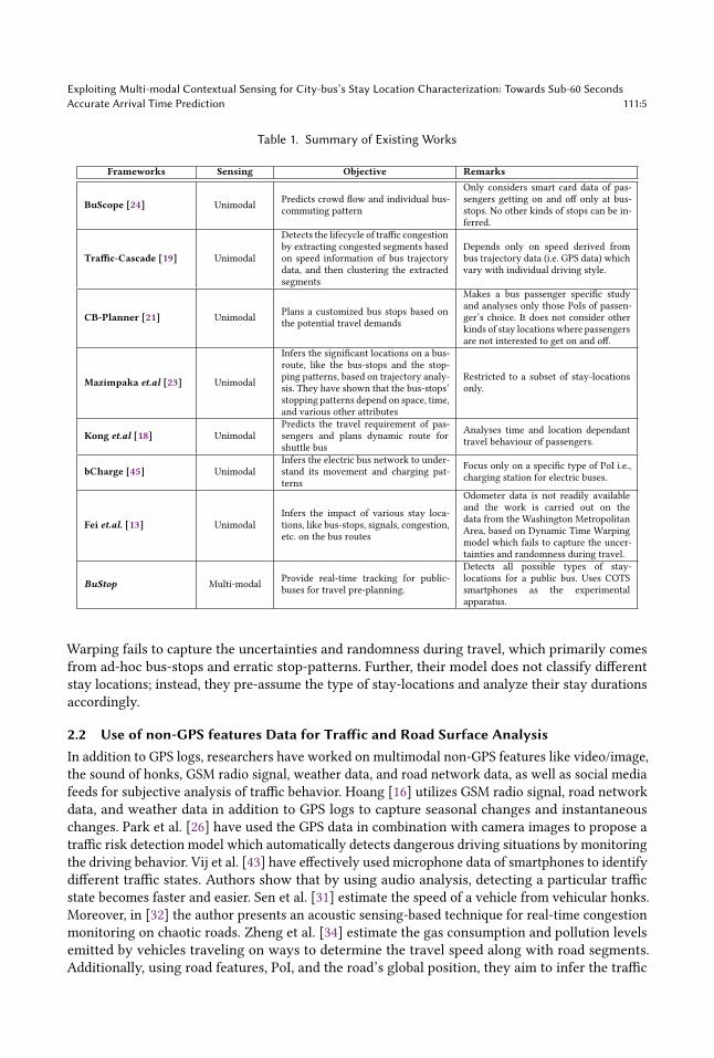
Exploiting Multi-modal Contextual Sensing for City-bus’s Stay Location Characterization: Towards Sub-60 SecondsAccurate Arrival Time Prediction 111:5
Table 1. Summary of Existing Works
Frameworks Sensing Objective Remarks
BuScope [24] Unimodal Predicts crowd flow and individual bus-commuting pattern
Only considers smart card data of pas-sengers getting on and off only at bus-stops. No other kinds of stops can be in-ferred.
Traffic-Cascade [19] Unimodal
Detects the lifecycle of traffic congestionby extracting congested segments basedon speed information of bus trajectorydata, and then clustering the extractedsegments
Depends only on speed derived frombus trajectory data (i.e. GPS data) whichvary with individual driving style.
CB-Planner [21] Unimodal Plans a customized bus stops based onthe potential travel demands
Makes a bus passenger specific studyand analyses only those PoIs of passen-ger’s choice. It does not consider otherkinds of stay locationswhere passengersare not interested to get on and off.
Mazimpaka et.al [23] Unimodal
Infers the significant locations on a bus-route, like the bus-stops and the stop-ping patterns, based on trajectory analy-sis. They have shown that the bus-stops’stopping patterns depend on space, time,and various other attributes
Restricted to a subset of stay-locationsonly.
Kong et.al [18] UnimodalPredicts the travel requirement of pas-sengers and plans dynamic route forshuttle bus
Analyses time and location dependanttravel behaviour of passengers.
bCharge [45] UnimodalInfers the electric bus network to under-stand its movement and charging pat-terns
Focus only on a specific type of PoI i.e.,charging station for electric buses.
Fei et.al. [13] UnimodalInfers the impact of various stay loca-tions, like bus-stops, signals, congestion,etc. on the bus routes
Odometer data is not readily availableand the work is carried out on thedata from the Washington MetropolitanArea, based on Dynamic Time Warpingmodel which fails to capture the uncer-tainties and randomness during travel.
BuStop Multi-modal Provide real-time tracking for public-buses for travel pre-planning.
Detects all possible types of stay-locations for a public bus. Uses COTSsmartphones as the experimentalapparatus.
Warping fails to capture the uncertainties and randomness during travel, which primarily comesfrom ad-hoc bus-stops and erratic stop-patterns. Further, their model does not classify differentstay locations; instead, they pre-assume the type of stay-locations and analyze their stay durationsaccordingly.
2.2 Use of non-GPS features Data for Traffic and Road Surface AnalysisIn addition to GPS logs, researchers have worked on multimodal non-GPS features like video/image,the sound of honks, GSM radio signal, weather data, and road network data, as well as social mediafeeds for subjective analysis of traffic behavior. Hoang [16] utilizes GSM radio signal, road networkdata, and weather data in addition to GPS logs to capture seasonal changes and instantaneouschanges. Park et al. [26] have used the GPS data in combination with camera images to propose atraffic risk detection model which automatically detects dangerous driving situations by monitoringthe driving behavior. Vij et al. [43] have effectively used microphone data of smartphones to identifydifferent traffic states. Authors show that by using audio analysis, detecting a particular trafficstate becomes faster and easier. Sen et al. [31] estimate the speed of a vehicle from vehicular honks.Moreover, in [32] the author presents an acoustic sensing-based technique for real-time congestionmonitoring on chaotic roads. Zheng et al. [34] estimate the gas consumption and pollution levelsemitted by vehicles traveling on ways to determine the travel speed along with road segments.Additionally, using road features, PoI, and the road’s global position, they aim to infer the traffic
111:6 Mandal, et al.
volume from travel speed. In another approach, Wang et al. [46] combine social media data withroad features to identify traffic congestion on city roads. They estimate citywide traffic congestionfrom social media by mining the road segments’ spatial and temporal correlations facing congestionfrom historical data. The authors extracted the physical features of roads from road network data.They also measured the impact of a social event on nearby road segments. Hence, the above-studiedfeatures can be used along with GPS to infer traffic behavior to a certain extent. However, the roadsurface condition also plays a vital role in affecting the speed of vehicles.
Extensive literature study shows that researchers either have combined online data with sensordata or have combined historical logs of traffic data with smartphone-like GPS, accelerometerdata, microphone data, and mobile phone signals to provide proper road and traffic information.Eriksson [11] developed a Pothole Patrol system to detect road anomalies using accelerometersand GPS sensors installed in taxis. Mohan [25] presented a system to monitor road conditions bydetecting potholes, bumps, honking from an accelerometer, microphone, GSM radio signal, andGPS data. Vittorio [3] applied the anomaly detection method on mobile devices based on verticalacceleration and GPS signals. Perttunen [27] proposed a road anomaly detection method using GPSand acceleration signals. Wolverine [4] used smartphone sensors to detect road conditions andbumps. The authors have proposed a reorientation using a magnetometer beside the accelerometerand GPS sensors. Nuno Silva [35] detects road condition from GPS and accelerometer data. HaofuHan [15] estimates speed from an accelerometer, which senses natural driving conditions in urbanenvironments, including making turns, stopping, and passing through uneven road surfaces. Theycontribute to eliminating the errors in speed estimation caused by accelerations in real-time. A.Chowdhury [2] investigated the noise performance of accelerometers available in smartphonesand finally apply the analysis for estimating the speed of moving vehicles because sudden changesin vehicle speed are not always captured well by GPS.
3 DATASETUnderstanding the limitations of the existing state-of-the-art systems for digitizing public businfrastructures, the first observation we gain is that such a system needs to have multi-modalsensing to effectively use various modalities to extract a diverse set of contextual informationsurrounding a stay-location. However, before diving into the actual framework development, wefirst look into how and which kind of dataset can be effectively captured considering smartphonesas the primary experimental apparatus. For this, we launch an extensive data collection drivesummarised as follows.
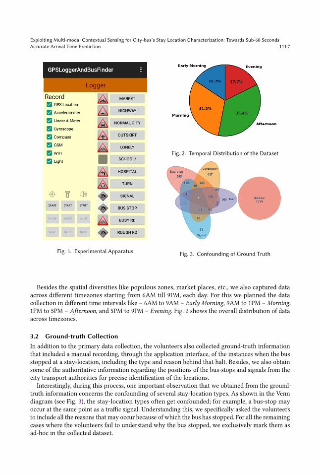
3.1 Data Acquisition FrameworkFor the data collection, we recruited 6 volunteers who were asked to travel across the sub-urban cityof Durgapur, India, on intra-city buses, while capturing sensor logs through an Android applicationinstalled on COTS smartphones (5 different builds from a price range of USD 83$–210$). Thedesigned Android application acted as the primary experimental apparatus during this entireprocess of data collection. As shown in Fig. 1, the application captured logs from various sensorslike GPS (sampled at 1 Hz), IMU (accelerometer and gyroscope sampled at 197 Hz), WiFi accesspoint information and microphones (sampled at 8 kHz) embedded in the smartphones.Once the initial set of data was collected, we then analyzed the dataset for identifying one or
more bus routes with substantial diversity of populous areas, market places, railway stations, etc.Subsequently, we chose a particular route for the remaining data collection, which has the desireddiversity for an overall principled analysis of the designed framework and collected the bus tripdata over 20 days using the aforementioned app. In this data collection, each round trip covered atotal of 24km, and the total distance covered during this entire period is 720km.
Exploiting Multi-modal Contextual Sensing for City-bus’s Stay Location Characterization: Towards Sub-60 SecondsAccurate Arrival Time Prediction 111:7
Fig. 1. Experimental Apparatus
Fig. 2. Temporal Distribution of the Dataset
Fig. 3. Confounding of Ground Truth
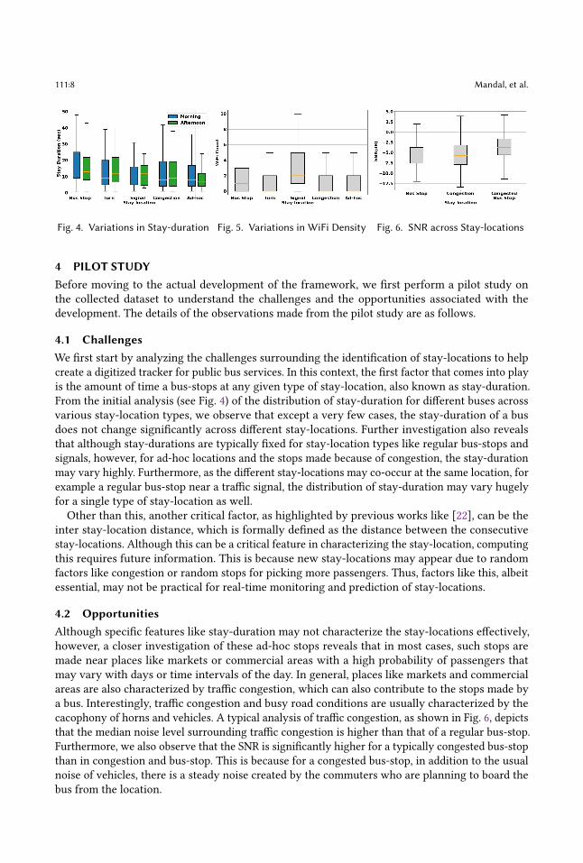
Besides the spatial diversities like populous zones, market places, etc., we also captured dataacross different timezones starting from 6AM till 9PM, each day. For this we planned the datacollection in different time intervals like – 6AM to 9AM – Early Morning, 9AM to 1PM – Morning,1PM to 5PM – Afternoon, and 5PM to 9PM – Evening. Fig. 2 shows the overall distribution of dataacross timezones.
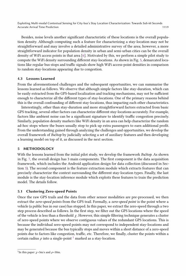
3.2 Ground-truth CollectionIn addition to the primary data collection, the volunteers also collected ground-truth informationthat included a manual recording, through the application interface, of the instances when the busstopped at a stay-location, including the type and reason behind that halt. Besides, we also obtainsome of the authoritative information regarding the positions of the bus-stops and signals from thecity transport authorities for precise identification of the locations.
Interestingly, during this process, one important observation that we obtained from the ground-truth information concerns the confounding of several stay-location types. As shown in the Venndiagram (see Fig. 3), the stay-location types often get confounded; for example, a bus-stop mayoccur at the same point as a traffic signal. Understanding this, we specifically asked the volunteersto include all the reasons that may occur because of which the bus has stopped. For all the remainingcases where the volunteers fail to understand why the bus stopped, we exclusively mark them asad-hoc in the collected dataset.
111:8 Mandal, et al.
Fig. 4. Variations in Stay-duration Fig. 5. Variations in WiFi Density Fig. 6. SNR across Stay-locations
4 PILOT STUDYBefore moving to the actual development of the framework, we first perform a pilot study onthe collected dataset to understand the challenges and the opportunities associated with thedevelopment. The details of the observations made from the pilot study are as follows.
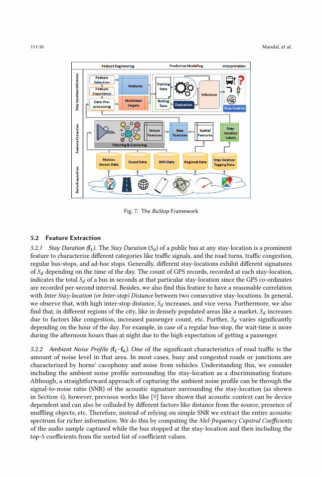
4.1 ChallengesWe first start by analyzing the challenges surrounding the identification of stay-locations to helpcreate a digitized tracker for public bus services. In this context, the first factor that comes into playis the amount of time a bus-stops at any given type of stay-location, also known as stay-duration.From the initial analysis (see Fig. 4) of the distribution of stay-duration for different buses acrossvarious stay-location types, we observe that except a very few cases, the stay-duration of a busdoes not change significantly across different stay-locations. Further investigation also revealsthat although stay-durations are typically fixed for stay-location types like regular bus-stops andsignals, however, for ad-hoc locations and the stops made because of congestion, the stay-durationmay vary highly. Furthermore, as the different stay-locations may co-occur at the same location, forexample a regular bus-stop near a traffic signal, the distribution of stay-duration may vary hugelyfor a single type of stay-location as well.Other than this, another critical factor, as highlighted by previous works like [22], can be the
inter stay-location distance, which is formally defined as the distance between the consecutivestay-locations. Although this can be a critical feature in characterizing the stay-location, computingthis requires future information. This is because new stay-locations may appear due to randomfactors like congestion or random stops for picking more passengers. Thus, factors like this, albeitessential, may not be practical for real-time monitoring and prediction of stay-locations.
4.2 OpportunitiesAlthough specific features like stay-duration may not characterize the stay-locations effectively,however, a closer investigation of these ad-hoc stops reveals that in most cases, such stops aremade near places like markets or commercial areas with a high probability of passengers thatmay vary with days or time intervals of the day. In general, places like markets and commercialareas are also characterized by traffic congestion, which can also contribute to the stops made bya bus. Interestingly, traffic congestion and busy road conditions are usually characterized by thecacophony of horns and vehicles. A typical analysis of traffic congestion, as shown in Fig. 6, depictsthat the median noise level surrounding traffic congestion is higher than that of a regular bus-stop.Furthermore, we also observe that the SNR is significantly higher for a typically congested bus-stopthan in congestion and bus-stop. This is because for a congested bus-stop, in addition to the usualnoise of vehicles, there is a steady noise created by the commuters who are planning to board thebus from the location.
Exploiting Multi-modal Contextual Sensing for City-bus’s Stay Location Characterization: Towards Sub-60 SecondsAccurate Arrival Time Prediction 111:9
Besides, noise levels another significant characteristic of these locations is the overall popula-tion density. Although computing such a feature for characterizing a stay-location may not bestraightforward and may involve a detailed administrative survey of the area; however, a morestraightforward indicator for population density in urban and semi-urban cities can be the overalldensity of WiFi access points in that area [6]. Motivated by this, we perform a simple pilot study tocompute the WiFi density surrounding different stay-locations. As shown in Fig. 5, demarcated loca-tions like regular bus-stops and traffic signals show high WiFi access-point densities in comparisonto random stay-locations appearing due to congestion.
4.3 Lessons LearnedFrom the aforementioned challenges and the subsequent opportunities, we can summarise thelessons learned as follows. We observe that although simple factors like stay-duration, which canbe easily extracted from the GPS-based localization and tracking mechanisms, may not be sufficientenough to characterize all the different types of stay-locations. One of the primary reasons behindthis is the overall confounding of different stay-locations, thus impacting each other characteristics.Interestingly, other than stay-duration and more straightforward factors extracted from basic
GPS tracking, several other factors can characterize different stay-locations accurately. For example,factors like ambient noise can be a significant signature to identify traffic congestion precisely.Similarly, population density markers like WiFi density in an area can help characterize the randomad-hoc stops where the buses usually stop to pick up extra passengers to earn additional profit.From the understanding gained through analyzing the challenges and opportunities, we develop theoverall framework of BuStop by judicially selecting a set of auxiliary features and then developinga learning model on top of it, as discussed in the next section.
5 METHODOLOGYWith the lessons learned from the initial pilot study, we develop the framework BuStop. As shownin Fig. 7, the overall design has 3 main components. The first component is the data acquisitionframework, which includes the Android application design for data collection (discussed in Sec-tion 3). The second component is the feature extraction module which extracts features that canprecisely characterize the context surrounding the different stay-location types. Finally, the lastmodule is the stay-location inference module which exploits these features to train the predictionmodel. The details follow.
5.1 Clustering Zero-speed PointsOnce the raw GPS trails and the data from other sensor modalities are pre-processed, we thenextract the zero-speed points from the GPS trail. Formally, a zero-speed point is the point where avehicle (a public bus in our case) has stopped. In this paper, we extract the zero-speed through a twostep process described as follows. In the first step, we filter out the GPS locations where the speedof the vehicle is less than a threshold 𝜒 . However, this simple filtering technique generates a clusterof zero-speed points where we observe contiguous values of the redundant GPS locations. This isbecause the individual zero-speed points may not correspond to independent stay-locations andmay be generated because the bus typically stops and moves within a short distance of a zero-speedpoints due to factors like congestion, traffic, etc. Therefore, we finally, cluster the points within acertain radius 𝜌 into a single-point 1 marked as a stay-location.
1In this paper 𝜒=3m/s and 𝜌=30m.
111:10 Mandal, et al.
Fig. 7. The BuStop Framework
5.2 Feature Extraction5.2.1 Stay Duration (f1). The Stay Duration (𝑆𝑑 ) of a public bus at any stay-location is a prominentfeature to characterize different categories like traffic signals, and the road turns, traffic congestion,regular bus-stops, and ad-hoc stops. Generally, different stay-locations exhibit different signaturesof 𝑆𝑑 depending on the time of the day. The count of GPS records, recorded at each stay-location,indicates the total 𝑆𝑑 of a bus in seconds at that particular stay-location since the GPS co-ordinatesare recorded per-second interval. Besides, we also find this feature to have a reasonable correlationwith Inter Stay-location (or Inter-stop) Distance between two consecutive stay-locations. In general,we observe that, with high inter-stop distance, 𝑆𝑑 increases, and vice versa. Furthermore, we alsofind that, in different regions of the city, like in densely populated areas like a market, 𝑆𝑑 increasesdue to factors like congestion, increased passenger count, etc. Further, 𝑆𝑑 varies significantlydepending on the hour of the day. For example, in case of a regular bus-stop, the wait-time is moreduring the afternoon hours than at night due to the high expectation of getting a passenger.
5.2.2 Ambient Noise Profile (f2–f6). One of the significant characteristics of road traffic is theamount of noise level in that area. In most cases, busy and congested roads or junctions arecharacterized by horns’ cacophony and noise from vehicles. Understanding this, we considerincluding the ambient noise profile surrounding the stay-location as a discriminating feature.Although, a straightforward approach of capturing the ambient noise profile can be through thesignal-to-noise ratio (SNR) of the acoustic signature surrounding the stay-location (as shownin Section 4), however, previous works like [9] have shown that acoustic context can be devicedependent and can also be colluded by different factors like distance from the source, presence ofmuffling objects, etc. Therefore, instead of relying on simple SNR we extract the entire acousticspectrum for richer information. We do this by computing the Mel-frequency Cepstral Coefficientsof the audio sample captured while the bus stopped at the stay-location and then including thetop-5 coefficients from the sorted list of coefficient values.
Exploiting Multi-modal Contextual Sensing for City-bus’s Stay Location Characterization: Towards Sub-60 SecondsAccurate Arrival Time Prediction 111:11
Fig. 8. Encoding Spatial Distribution Fig. 9. Architecture of the Prediction Model
5.2.3 Unique WiFi Hotspot Availability (f7–f8). Many public spaces like railway stations, offices,malls, and shopping complexes have placed WiFi hotspots for seamless connectivity in the recentpast. Additionally, wireless access points are also found in private residential areas as well. Withrecent endeavors in making smartphones act as WiFi hotspots, the abundance of these accesspoints has increased manifolds. Interestingly, the density of WiFi access points in an area has beenobserved to be a good indicator of the overall population density [6, 17], which can, in turn, bea motivating factor for predicting the stay-location type of a public bus. Therefore, we extractthe list of unique WiFi access-points in a stay-point and use the access points’ count as a feature.Additionally, we also observe the list of unique WiFi count while the bus moves from one stay-location to another. This additional information also gives us an idea of the commuters’ overallflow between the various stay-locations and finally helps us better characterize it for prediction.
5.2.4 Road Surface Profile (f9). The condition of the road surface is a significant factor for deter-mining the stay location of a bus. Buses typically slow down when the road condition is poor. Poorroad conditions in densely populous and busy areas also leads to traffic congestion. As a result, wefind that the Road Surface Index (RSI) has a good correlation with the increase in stay-duration.Therefore, we conclude that the road surface index, 𝑅𝐼 could be a vital feature to characterize thedifferent type of stay-locations. Existing literature [25] have shown that data from IMU sensorslike accelerometer can be used to compute RSI of a road. In particular, the z-axis of accelerometeris seen to vary within a specific range for poor road conditions. Thus, to compute the RSI, we firstprocess the accelerometer data, obtained from the smartphone application, to orient it according tothe actual z-axis and then subsequently use the z-axis value to compute the RSI adapted as follows.We first take a window of 50 meters before a stay-location and capture the z-axis acceleration
for that entire window, along with the velocity of the bus. Subsequently, the RSI can be calculatedas the ratio of root mean square (RMS) of the z-axis acceleration values and the mean of the velocityin that window.
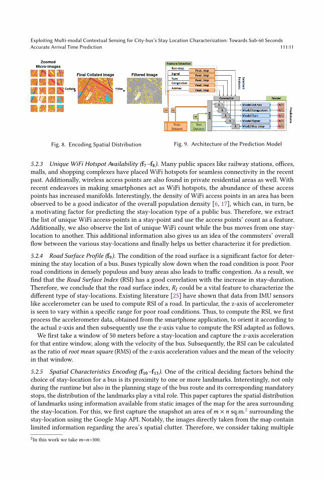
5.2.5 Spatial Characteristics Encoding (f10–f13). One of the critical deciding factors behind thechoice of stay-location for a bus is its proximity to one or more landmarks. Interestingly, not onlyduring the runtime but also in the planning stage of the bus route and its corresponding mandatorystops, the distribution of the landmarks play a vital role. This paper captures the spatial distributionof landmarks using information available from static images of the map for the area surroundingthe stay-location. For this, we first capture the snapshot an area of𝑚 × 𝑛 sq.m.2 surrounding thestay-location using the Google Map API. Notably, the images directly taken from the map containlimited information regarding the area’s spatial clutter. Therefore, we consider taking multiple2In this work we take𝑚=𝑛=300.
111:12 Mandal, et al.
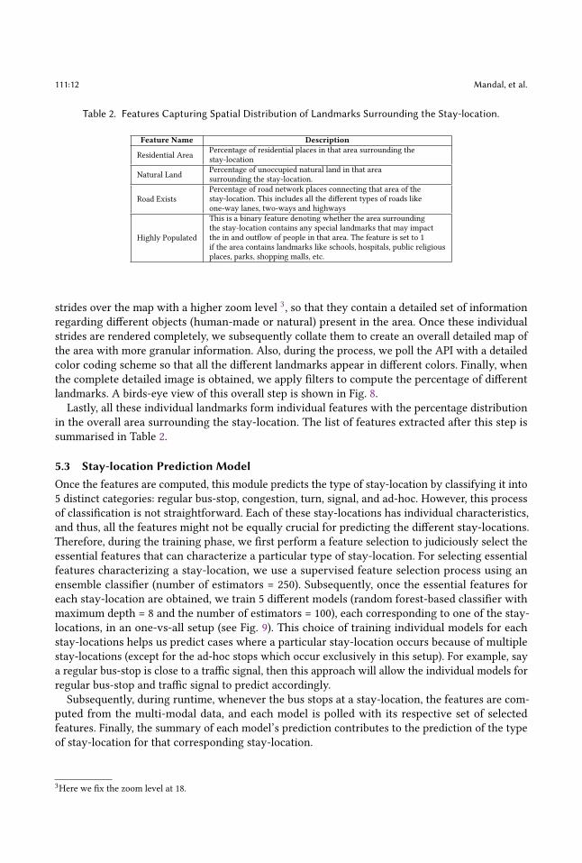
Table 2. Features Capturing Spatial Distribution of Landmarks Surrounding the Stay-location.
Feature Name Description
Residential Area Percentage of residential places in that area surrounding thestay-location
Natural Land Percentage of unoccupied natural land in that areasurrounding the stay-location.
Road ExistsPercentage of road network places connecting that area of thestay-location. This includes all the different types of roads likeone-way lanes, two-ways and highways
Highly Populated
This is a binary feature denoting whether the area surroundingthe stay-location contains any special landmarks that may impactthe in and outflow of people in that area. The feature is set to 1if the area contains landmarks like schools, hospitals, public religiousplaces, parks, shopping malls, etc.
strides over the map with a higher zoom level 3, so that they contain a detailed set of informationregarding different objects (human-made or natural) present in the area. Once these individualstrides are rendered completely, we subsequently collate them to create an overall detailed map ofthe area with more granular information. Also, during the process, we poll the API with a detailedcolor coding scheme so that all the different landmarks appear in different colors. Finally, whenthe complete detailed image is obtained, we apply filters to compute the percentage of differentlandmarks. A birds-eye view of this overall step is shown in Fig. 8.
Lastly, all these individual landmarks form individual features with the percentage distributionin the overall area surrounding the stay-location. The list of features extracted after this step issummarised in Table 2.
5.3 Stay-location Prediction ModelOnce the features are computed, this module predicts the type of stay-location by classifying it into5 distinct categories: regular bus-stop, congestion, turn, signal, and ad-hoc. However, this processof classification is not straightforward. Each of these stay-locations has individual characteristics,and thus, all the features might not be equally crucial for predicting the different stay-locations.Therefore, during the training phase, we first perform a feature selection to judiciously select theessential features that can characterize a particular type of stay-location. For selecting essentialfeatures characterizing a stay-location, we use a supervised feature selection process using anensemble classifier (number of estimators = 250). Subsequently, once the essential features foreach stay-location are obtained, we train 5 different models (random forest-based classifier withmaximum depth = 8 and the number of estimators = 100), each corresponding to one of the stay-locations, in an one-vs-all setup (see Fig. 9). This choice of training individual models for eachstay-locations helps us predict cases where a particular stay-location occurs because of multiplestay-locations (except for the ad-hoc stops which occur exclusively in this setup). For example, saya regular bus-stop is close to a traffic signal, then this approach will allow the individual models forregular bus-stop and traffic signal to predict accordingly.Subsequently, during runtime, whenever the bus stops at a stay-location, the features are com-
puted from the multi-modal data, and each model is polled with its respective set of selectedfeatures. Finally, the summary of each model’s prediction contributes to the prediction of the typeof stay-location for that corresponding stay-location.
3Here we fix the zoom level at 18.
Exploiting Multi-modal Contextual Sensing for City-bus’s Stay Location Characterization: Towards Sub-60 SecondsAccurate Arrival Time Prediction 111:13
(a) (b) (c)
Fig. 10. (a) Performance Evaluation and Feature Importance for Individual Models – (b) Regular Bus-stopsand (c) Random Ad-hoc Stops
(a) (b) (c)
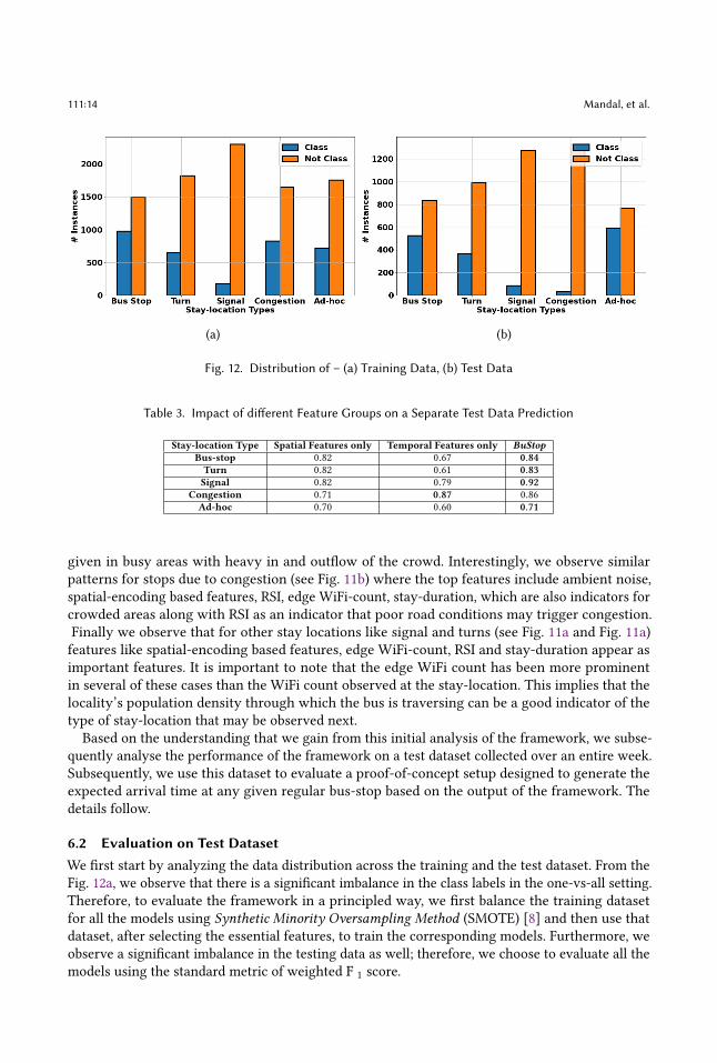
Fig. 11. Feature Importance for Individual Models – (a) Traffic Signal (b) Traffic Congestion, and (c) Turn
6 EVALUATIONWe evaluate the framework’s performance with the in-house collected data in two steps – (a)first with straightforward cross-validation and (b) a more realistic evaluation with test data for anentire week. Additionally, we also develop a proof-of-concept (PoC) system on top of the developedframework that can provide real-time information on bus arrival. The details follow.
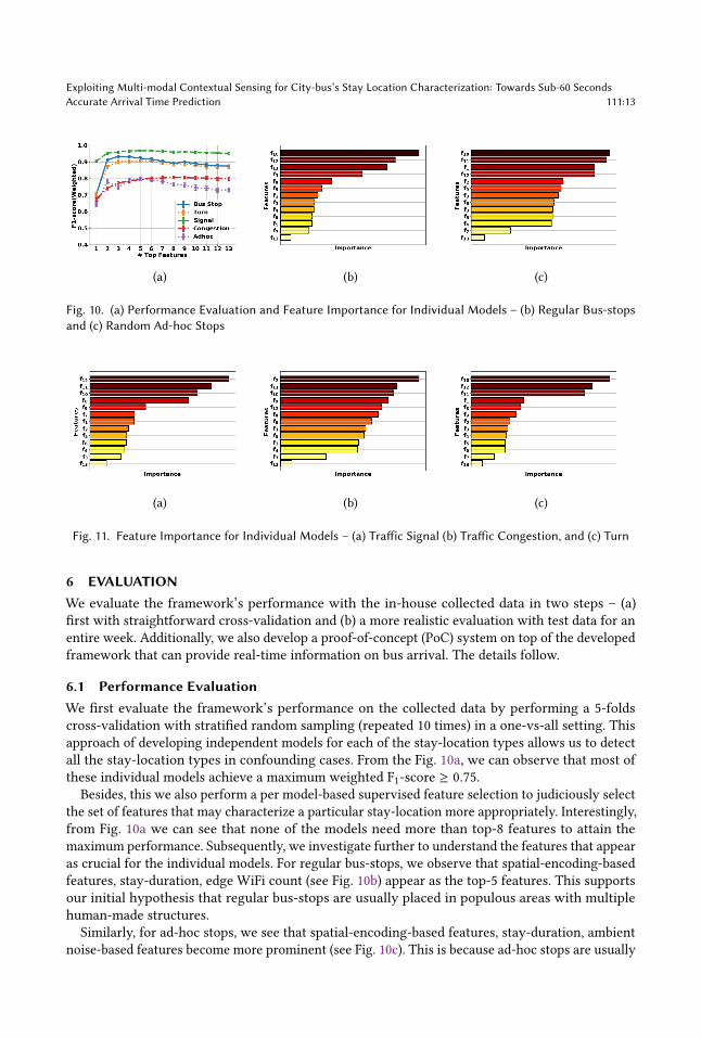
6.1 Performance EvaluationWe first evaluate the framework’s performance on the collected data by performing a 5-foldscross-validation with stratified random sampling (repeated 10 times) in a one-vs-all setting. Thisapproach of developing independent models for each of the stay-location types allows us to detectall the stay-location types in confounding cases. From the Fig. 10a, we can observe that most ofthese individual models achieve a maximum weighted F1-score ≥ 0.75.
Besides, this we also perform a per model-based supervised feature selection to judiciously selectthe set of features that may characterize a particular stay-location more appropriately. Interestingly,from Fig. 10a we can see that none of the models need more than top-8 features to attain themaximum performance. Subsequently, we investigate further to understand the features that appearas crucial for the individual models. For regular bus-stops, we observe that spatial-encoding-basedfeatures, stay-duration, edge WiFi count (see Fig. 10b) appear as the top-5 features. This supportsour initial hypothesis that regular bus-stops are usually placed in populous areas with multiplehuman-made structures.
Similarly, for ad-hoc stops, we see that spatial-encoding-based features, stay-duration, ambientnoise-based features become more prominent (see Fig. 10c). This is because ad-hoc stops are usually
111:14 Mandal, et al.
(a) (b)
Fig. 12. Distribution of – (a) Training Data, (b) Test Data
Table 3. Impact of different Feature Groups on a Separate Test Data Prediction
Stay-location Type Spatial Features only Temporal Features only BuStopBus-stop 0.82 0.67 0.84Turn 0.82 0.61 0.83Signal 0.82 0.79 0.92
Congestion 0.71 0.87 0.86Ad-hoc 0.70 0.60 0.71
given in busy areas with heavy in and outflow of the crowd. Interestingly, we observe similarpatterns for stops due to congestion (see Fig. 11b) where the top features include ambient noise,spatial-encoding based features, RSI, edge WiFi-count, stay-duration, which are also indicators forcrowded areas along with RSI as an indicator that poor road conditions may trigger congestion.Finally we observe that for other stay locations like signal and turns (see Fig. 11a and Fig. 11a)features like spatial-encoding based features, edge WiFi-count, RSI and stay-duration appear asimportant features. It is important to note that the edge WiFi count has been more prominentin several of these cases than the WiFi count observed at the stay-location. This implies that thelocality’s population density through which the bus is traversing can be a good indicator of thetype of stay-location that may be observed next.
Based on the understanding that we gain from this initial analysis of the framework, we subse-quently analyse the performance of the framework on a test dataset collected over an entire week.Subsequently, we use this dataset to evaluate a proof-of-concept setup designed to generate theexpected arrival time at any given regular bus-stop based on the output of the framework. Thedetails follow.
6.2 Evaluation on Test DatasetWe first start by analyzing the data distribution across the training and the test dataset. From theFig. 12a, we observe that there is a significant imbalance in the class labels in the one-vs-all setting.Therefore, to evaluate the framework in a principled way, we first balance the training datasetfor all the models using Synthetic Minority Oversampling Method (SMOTE) [8] and then use thatdataset, after selecting the essential features, to train the corresponding models. Furthermore, weobserve a significant imbalance in the testing data as well; therefore, we choose to evaluate all themodels using the standard metric of weighted F 1 score.
Exploiting Multi-modal Contextual Sensing for City-bus’s Stay Location Characterization: Towards Sub-60 SecondsAccurate Arrival Time Prediction 111:15
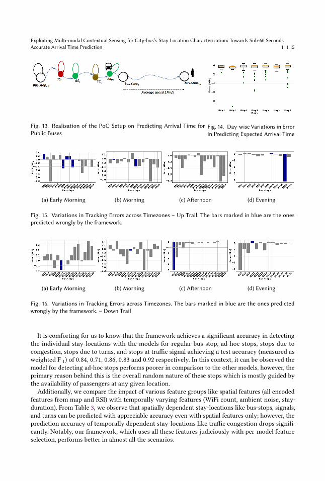
Fig. 13. Realisation of the PoC Setup on Predicting Arrival Time forPublic Buses
Fig. 14. Day-wise Variations in Errorin Predicting Expected Arrival Time
(a) Early Morning (b) Morning (c) Afternoon (d) Evening
Fig. 15. Variations in Tracking Errors across Timezones – Up Trail. The bars marked in blue are the onespredicted wrongly by the framework.
(a) Early Morning (b) Morning (c) Afternoon (d) Evening
Fig. 16. Variations in Tracking Errors across Timezones. The bars marked in blue are the ones predictedwrongly by the framework. – Down Trail
It is comforting for us to know that the framework achieves a significant accuracy in detectingthe individual stay-locations with the models for regular bus-stop, ad-hoc stops, stops due tocongestion, stops due to turns, and stops at traffic signal achieving a test accuracy (measured asweighted F 1) of 0.84, 0.71, 0.86, 0.83 and 0.92 respectively. In this context, it can be observed themodel for detecting ad-hoc stops performs poorer in comparison to the other models, however, theprimary reason behind this is the overall random nature of these stops which is mostly guided bythe availability of passengers at any given location.
Additionally, we compare the impact of various feature groups like spatial features (all encodedfeatures from map and RSI) with temporally varying features (WiFi count, ambient noise, stay-duration). From Table 3, we observe that spatially dependent stay-locations like bus-stops, signals,and turns can be predicted with appreciable accuracy even with spatial features only; however, theprediction accuracy of temporally dependent stay-locations like traffic congestion drops signifi-cantly. Notably, our framework, which uses all these features judiciously with per-model featureselection, performs better in almost all the scenarios.
111:16 Mandal, et al.
Table 4. Error (in Minutes) in Obtaining Expected Arrival Time at a Regular Bus-stops from Previously VisitedRegular Bus-stops
BS1 BS2 BS3 BS4 BS5 BS6 BS7 BS8 BS9 BS12 BS13 BS17 BS18 BS19 BS22BS1 -0.05 -3.58 -4.43 -4.45 -4.5 -4.63 -4.8 -5.38 -7.85 -8.77 -10.8 -14.87 -16.93 -18.75BS2 -3.53 -4.38 -4.4 -4.45 -4.58 -4.75 -5.33 -7.8 -8.72 -10.75 -14.82 -16.88 -18.7BS3 -0.85 -0.87 -0.92 -1.05 -1.22 -1.8 -4.27 -5.18 -7.22 -11.28 -13.35 -15.17BS4 -0.02 -0.07 -0.2 -0.37 -0.95 -3.42 -4.33 -6.37 -10.43 -12.5 -14.32BS5 -0.05 -0.18 -0.35 -0.93 -3.4 -4.32 -6.35 -10.42 -12.48 -14.3BS6 -0.13 -0.3 -0.88 -3.35 -4.27 -6.3 -10.37 -12.43 -14.25BS7 -0.17 -0.75 -3.22 -4.13 -6.17 -10.23 -12.3 -14.12BS8 -0.58 -3.05 -3.97 -6 -10.07 -12.13 -13.95BS9 -2.47 -3.38 -5.42 -9.48 -11.55 -13.37BS12 -0.92 -2.95 -7.02 -9.08 -10.9BS13 -2.03 -6.1 -8.17 -9.98BS17 -4.07 -6.13 -7.95BS18 -2.07 -3.88BS19 -1.82BS22
6.3 Proof-of-Concept Real-time Tracking of Public-busOne of the primary motivations behind developing BuStop is providing an overall service forreal-time tracking of public buses. As explained in previous sections, this real-time characterizingof stay-locations fine-tunes the tracking and provides the commuters with updated informationabout the bus’s arrival at their intended regular bus-stops. Therefore, based on this idea, we developa simple PoC system on top of BuStop and simulate the system over the test dataset. The details ofthe system and, subsequently, its evaluation follow.
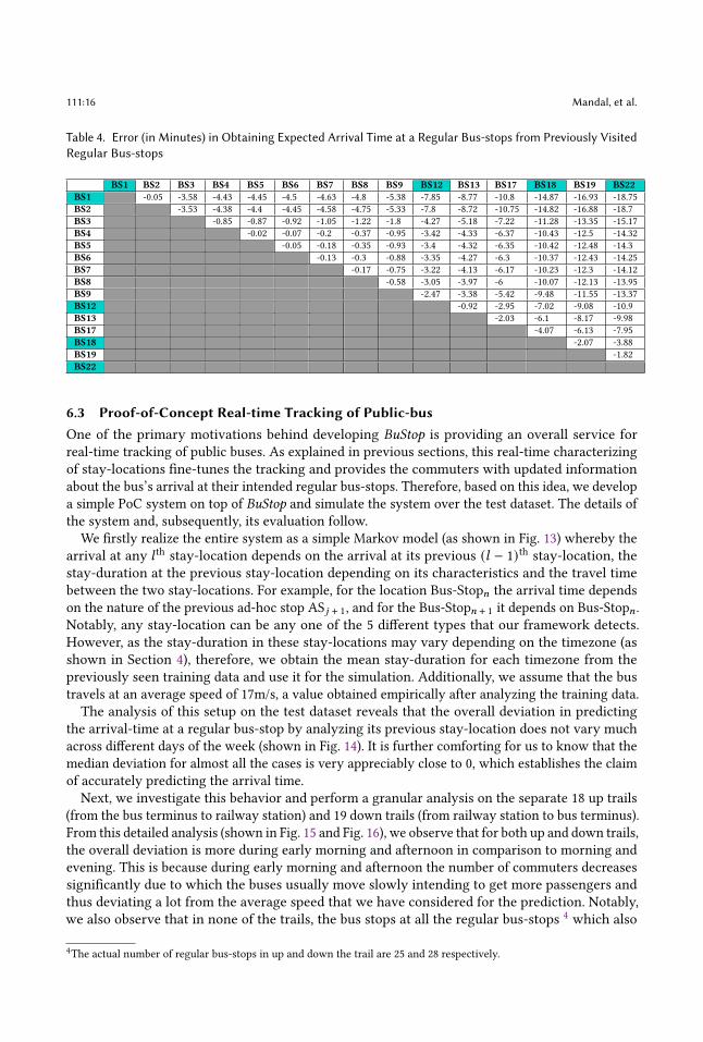
We firstly realize the entire system as a simple Markov model (as shown in Fig. 13) whereby thearrival at any 𝑙 th stay-location depends on the arrival at its previous (𝑙 − 1)th stay-location, thestay-duration at the previous stay-location depending on its characteristics and the travel timebetween the two stay-locations. For example, for the location Bus-Stop𝑛 the arrival time dependson the nature of the previous ad-hoc stop AS𝑗 + 1, and for the Bus-Stop𝑛 + 1 it depends on Bus-Stop𝑛 .Notably, any stay-location can be any one of the 5 different types that our framework detects.However, as the stay-duration in these stay-locations may vary depending on the timezone (asshown in Section 4), therefore, we obtain the mean stay-duration for each timezone from thepreviously seen training data and use it for the simulation. Additionally, we assume that the bustravels at an average speed of 17m/s, a value obtained empirically after analyzing the training data.The analysis of this setup on the test dataset reveals that the overall deviation in predicting
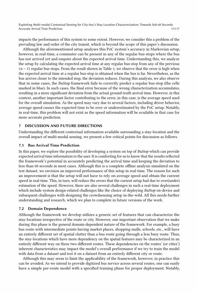
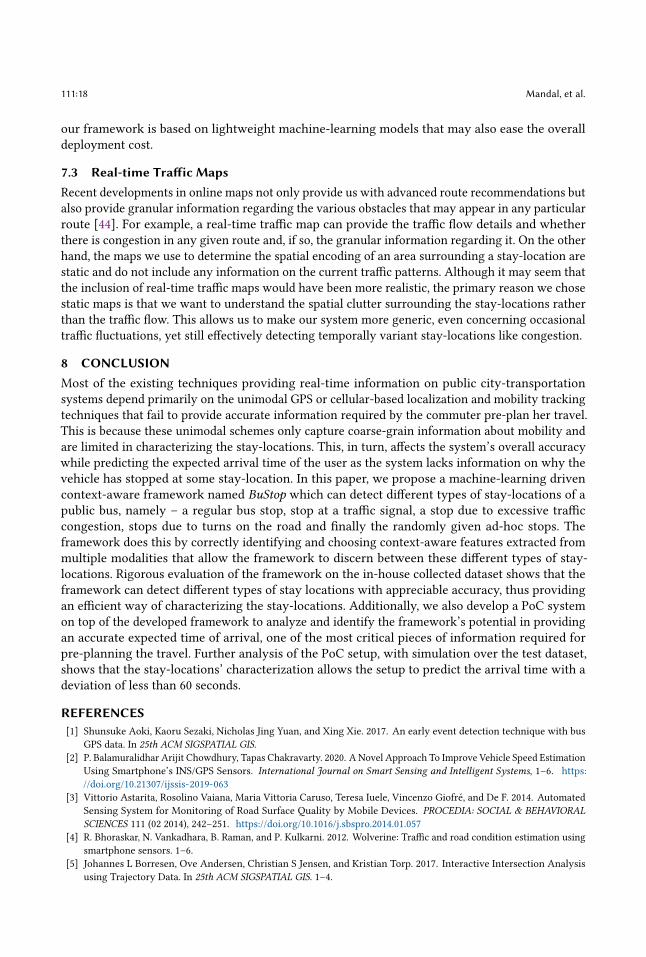
the arrival-time at a regular bus-stop by analyzing its previous stay-location does not vary muchacross different days of the week (shown in Fig. 14). It is further comforting for us to know that themedian deviation for almost all the cases is very appreciably close to 0, which establishes the claimof accurately predicting the arrival time.Next, we investigate this behavior and perform a granular analysis on the separate 18 up trails
(from the bus terminus to railway station) and 19 down trails (from railway station to bus terminus).From this detailed analysis (shown in Fig. 15 and Fig. 16), we observe that for both up and down trails,the overall deviation is more during early morning and afternoon in comparison to morning andevening. This is because during early morning and afternoon the number of commuters decreasessignificantly due to which the buses usually move slowly intending to get more passengers andthus deviating a lot from the average speed that we have considered for the prediction. Notably,we also observe that in none of the trails, the bus stops at all the regular bus-stops 4 which also
4The actual number of regular bus-stops in up and down the trail are 25 and 28 respectively.
Exploiting Multi-modal Contextual Sensing for City-bus’s Stay Location Characterization: Towards Sub-60 SecondsAccurate Arrival Time Prediction 111:17
impacts the performance of this system to some extent. However, we consider this a problem of theprevailing law and order of the city transit, which is beyond the scope of this paper’s discussion.Although the aforementioned setup analyses this PoC system’s accuracy in Markovian setup,
however, in real-time, a commuter can be present in any of the regular bus-stops where the bushas not arrived yet and enquire about the expected arrival time. Understanding this, we analyzethe setup by calculating the expected arrival time at any regular bus-stop from any of the previous(𝑛 − 1) regular bus-stops. From the result shown in Table 4, we observe that the error is high whenthe expected arrival time at a regular bus-stop is obtained when the bus is far. Nevertheless, as thebus arrives closer to the intended stop, the deviation reduces. During this analysis, we also observethat in some cases, the BuStop framework fails to correctly predict a regular bus-stop (the cellsmarked in blue). In such cases, the final error because of the wrong characterization accumulates,resulting in a more significant deviation from the actual ground-truth arrival time. However, in thiscontext, another important factor contributing to the error, in this case, is the average speed usedfor the overall simulation. As the speed may vary due to several factors, including driver behavior,average speed causes the expected time to be over or underestimated by the PoC setup. Notably,in real-time, this problem will not exist as the speed information will be available in that case formore accurate prediction.
7 DISCUSSION AND FUTURE DIRECTIONSUnderstanding the different contextual information available surrounding a stay-location and theoverall impact of multi-modal sensing, we present a few critical points for discussion as follows.
7.1 Bus Arrival Time PredictionIn this paper, we explore the possibility of developing a system on top of BuStop which can provideexpected arrival time information to the user. It is comforting for us to know that the results reflectedthe framework’s potential in accurately predicting the arrival time and keeping the deviation toless than 60 seconds in most cases. Although this is a complete offline analysis simulated on thetest dataset, we envision an improved performance of this setup in real-time. The reason for suchan improvement is that the setup will not have to rely on average speed and obtain the currentspeed in real-time. This, in turn, will reduce the errors that the current setup had due to over(under)estimation of the speed. However, there are also several challenges in such a real-time deploymentwhich include system design-related challenges like the choice of deploying BuStop on-device andsubsequent challenges with designing the crowdsensing setup in-the-wild. All this needs furtherunderstanding and research, which we plan to complete in future versions of the work.
7.2 Domain DependenceAlthough the framework we develop utilizes a generic set of features that can characterize thestay-locations irrespective of the route or city. However, one important observation that we makeduring this phase is the general domain-dependent nature of the framework. For example, a busybus route with intermediate points having market places, shopping malls, schools, etc., will havean entirely different set of spatial clutter than a bus route going through a less busy route. Thus,the stay-locations which have more dependency on the spatial features may be characterized in anentirely different way on these two different routes. These dependencies on the routes’ (or cities’)inherent characteristics may impact the model’s overall performance if we try to train the modelwith data from a dataset and test it on a dataset from an entirely different city or route.
Although this may seem to limit the applicability of the framework, however, in practice thiscan be avoided. As we intend to provide digitized bus service across several routes, one can easilyhave a simple per-route model with a specified training phase for proper deployment. Notably,
111:18 Mandal, et al.
our framework is based on lightweight machine-learning models that may also ease the overalldeployment cost.
7.3 Real-time Traffic MapsRecent developments in online maps not only provide us with advanced route recommendations butalso provide granular information regarding the various obstacles that may appear in any particularroute [44]. For example, a real-time traffic map can provide the traffic flow details and whetherthere is congestion in any given route and, if so, the granular information regarding it. On the otherhand, the maps we use to determine the spatial encoding of an area surrounding a stay-location arestatic and do not include any information on the current traffic patterns. Although it may seem thatthe inclusion of real-time traffic maps would have been more realistic, the primary reason we chosestatic maps is that we want to understand the spatial clutter surrounding the stay-locations ratherthan the traffic flow. This allows us to make our system more generic, even concerning occasionaltraffic fluctuations, yet still effectively detecting temporally variant stay-locations like congestion.
8 CONCLUSIONMost of the existing techniques providing real-time information on public city-transportationsystems depend primarily on the unimodal GPS or cellular-based localization and mobility trackingtechniques that fail to provide accurate information required by the commuter pre-plan her travel.This is because these unimodal schemes only capture coarse-grain information about mobility andare limited in characterizing the stay-locations. This, in turn, affects the system’s overall accuracywhile predicting the expected arrival time of the user as the system lacks information on why thevehicle has stopped at some stay-location. In this paper, we propose a machine-learning drivencontext-aware framework named BuStop which can detect different types of stay-locations of apublic bus, namely – a regular bus stop, stop at a traffic signal, a stop due to excessive trafficcongestion, stops due to turns on the road and finally the randomly given ad-hoc stops. Theframework does this by correctly identifying and choosing context-aware features extracted frommultiple modalities that allow the framework to discern between these different types of stay-locations. Rigorous evaluation of the framework on the in-house collected dataset shows that theframework can detect different types of stay locations with appreciable accuracy, thus providingan efficient way of characterizing the stay-locations. Additionally, we also develop a PoC systemon top of the developed framework to analyze and identify the framework’s potential in providingan accurate expected time of arrival, one of the most critical pieces of information required forpre-planning the travel. Further analysis of the PoC setup, with simulation over the test dataset,shows that the stay-locations’ characterization allows the setup to predict the arrival time with adeviation of less than 60 seconds.
REFERENCES[1] Shunsuke Aoki, Kaoru Sezaki, Nicholas Jing Yuan, and Xing Xie. 2017. An early event detection technique with bus
GPS data. In 25th ACM SIGSPATIAL GIS.[2] P. Balamuralidhar Arijit Chowdhury, Tapas Chakravarty. 2020. A Novel Approach To Improve Vehicle Speed Estimation
Using Smartphone’s INS/GPS Sensors. International Journal on Smart Sensing and Intelligent Systems, 1–6. https://doi.org/10.21307/ijssis-2019-063
[3] Vittorio Astarita, Rosolino Vaiana, Maria Vittoria Caruso, Teresa Iuele, Vincenzo Giofré, and De F. 2014. AutomatedSensing System for Monitoring of Road Surface Quality by Mobile Devices. PROCEDIA: SOCIAL & BEHAVIORALSCIENCES 111 (02 2014), 242–251. https://doi.org/10.1016/j.sbspro.2014.01.057
[4] R. Bhoraskar, N. Vankadhara, B. Raman, and P. Kulkarni. 2012. Wolverine: Traffic and road condition estimation usingsmartphone sensors. 1–6.
[5] Johannes L Borresen, Ove Andersen, Christian S Jensen, and Kristian Torp. 2017. Interactive Intersection Analysisusing Trajectory Data. In 25th ACM SIGSPATIAL GIS. 1–4.

Exploiting Multi-modal Contextual Sensing for City-bus’s Stay Location Characterization: Towards Sub-60 SecondsAccurate Arrival Time Prediction 111:19
[6] Radoslav Buchakchiev. [n.d.]. People density estimation using Wi-Fi infrastructure. Ph.D. Dissertation.[7] Bruce Chapman, Hiroyuki Iseki, Brian D Taylor, and Mark Miller. 2006. The effects of out-of-vehicle time on travel
behavior: Implications for transit transfers (deliverable# 1). CA: California Department of Transportation (2006).[8] N. V. Chawla, K. W. Bowyer, L. O. Hall, and W. P. Kegelmeyer. 2002. SMOTE: Synthetic Minority Over-sampling
Technique. J. Artif. Int. Res. (2002), 321–357.[9] Snigdha Das, Soumyajit Chatterjee, Sandip Chakraborty, and Bivas Mitra. 2018. Groupsense: A lightweight framework
for group identification. IEEE Transactions on Mobile Computing 18, 12 (2018), 2856–2870.[10] Massimo De Marchi, Jakob Eriksson, and Angus Graeme Forbes. 2015. TransitTrace: route planning using ambient
displays. In 23rd ACM SIGSPATIAL GIS.[11] Jakob Eriksson, Lewis Girod, Bret Hull, Ryan Newton, Samuel Madden, and Hari Balakrishnan. 2008. The Pothole
Patrol: Using a mobile sensor network for road surface monitoring. MobiSys’08 - Proceedings of the 6th InternationalConference on Mobile Systems, Applications, and Services, 29–39. https://doi.org/10.1145/1378600.1378605
[12] X. Fei and O. Gkountouna. 2018. Spatiotemporal clustering in urban transportation: a bus route case study in washingtonDC. SIGSPATIAL Special 10, 2, 26–33.
[13] Xiqi Fei, Olga Gkountouna, Dieter Pfoser, and Andreas Züfle. 2019. Spatiotemporal Bus Route Profiling using OdometerData. In 27th ACM SIGSPATIAL GIS. 369–378.
[14] Ashraful Hakim, Tanzima Hashem, and Mohammed Eunus Ali. 2017. Quantification and Prediction Models for theImpact of POIs on Road Traffic Congestion in Developing Countries. In 9th ICTD. 1–11.
[15] Jiawei Han et al. 2001. Spatial Clustering Methods in Data Mining: A Survey. In Geographic Data Mining and KnowledgeDiscovery, Research Monographs in GIS. Taylor and Francis.
[16] Minh X. Hoang, Yu Zheng, and Ambuj K. Singh. 2016. FCCF: Forecasting Citywide Crowd Flows Based on Big Data. InProceeding of the 24rd ACM International Conference on Advances in Geographical Information Systems (ACM SIGSPATIAL2016) (proceeding of the 24rd acm international conference on advances in geographical information systems (acmsigspatial 2016) ed.). ACM SIGSPATIAL 2016. https://www.microsoft.com/en-us/research/publication/forecasting-citywide-crowd-flows-based-big-data/
[17] Kipp Jones and Ling Liu. 2007. What where wi: An analysis of millions of wi-fi access points. In 2007 IEEE InternationalConference on Portable Information Devices. IEEE, 1–4.
[18] Xiangjie Kong, Menglin Li, Tao Tang, Kaiqi Tian, Luis Moreira-Matias, and Feng Xia. 2018. Shared subway shuttlebus route planning based on transport data analytics. IEEE Transactions on Automation Science and Engineering 15, 4(2018), 1507–1520.
[19] A. T. Kwee, M. Chiang, P. K. Prasetyo, and E. Lim. 2018. Traffic-cascade: Mining and visualizing lifecycles of trafficcongestion events using public bus trajectories. In 27th ACM CIKM. 1955–1958.
[20] Wang-Chien Lee, Weiping Si, Ling-Jyh Chen, and Meng Chang Chen. 2012. HTTP: a new framework for bus traveltime prediction based on historical trajectories. In 20th ACM SIGSPATIAL GIS. 279–288.
[21] Yan Lyu, Chi-Yin Chow, Victor CS Lee, Joseph KY Ng, Yanhua Li, and Jia Zeng. 2019. CB-Planner: A bus line planningframework for customized bus systems. Transportation Research Part C: Emerging Technologies 101 (2019), 233–253.
[22] Ratna Mandal, Prasenjit Karmakar, Abhijit Roy, Arpan Saha, Soumyajit Chatterjee, Sandip Chakraborty, Sujoy Saha,and Subrata Nandi. 2020. Ad-HocBusPoI: Context Analysis of Ad-Hoc Stay-Locations from Intra-City Bus Mobility andSmartphone Crowdsensing. Association for Computing Machinery, New York, NY, USA, 457–460. https://doi.org/10.1145/3397536.3422273
[23] J. D. Mazimpaka and S. Timpf. 2016. A visual and computational analysis approach for exploring significant locationsand time periods along a bus route. In 9th ACM SIGSPATIAL IWCTS. 43–48.
[24] L. Meegahapola, T. Kandappu, K. Jayarajah, L. Akoglu, S. Xiang, and A. Misra. 2019. Buscope: Fusing individual &aggregated mobility behavior for “live” smart city services. In 17th ACM MobiSys. 41–53.
[25] Prashanth Mohan, Venkata N. Padmanabhan, and Ramachandran Ramjee. 2008. Nericell: Rich Monitoring of Road andTraffic Conditions Using Mobile Smartphones (SenSys ’08). ACM, 323–336.
[26] Soyoung Park, Homin Han, Byeong-Su Kim, Jun-Ho Noh, Jeonghee Chi, and Mi-Jung Choi. 2018. Real-Time TrafficRisk Detection Model Using Smart Mobile Device. Sensors 18 (10 2018), 3686. https://doi.org/10.3390/s18113686
[27] Mikko Perttunen, Oleksiy Mazhelis, Fengyu Cong, Mikko Kauppila, Teemu Leppänen, Jouni Kantola, Jussi Collin,Susanna Pirttikangas, Janne Haverinen, and Jukka Riekki. 2011. Distributed Road Surface Condition Monitoring UsingMobile Phones. 64–78. https://doi.org/10.1007/978-3-642-23641-9_8
[28] Hasan Poonawala, Vinay Kolar, Sebastien Blandin, Laura Wynter, and Sambit Sahu. 2016. Singapore in motion: Insightson public transport service level through farecard and mobile data analytics. In 22nd ACM SIGKDD. 589–598.
[29] Jayanth Raghothama, Vinutha Magal Shreenath, and Sebastiaan Meijer. 2016. Analytics on public transport delayswith spatial big data. In 5th ACM SIGSPATIAL BigSpatial. 28–33.
[30] Rudy Raymond, Takamitsu Sugiura, and Kota Tsubouchi. 2011. Location recommendation based on location historyand spatio-temporal correlations for an on-demand bus system. In 19th ACM SIGSPATIAL GIS. 377–380.

111:20 Mandal, et al.
[31] Rijurekha Sen, Bhaskaran Raman, and Prashima Sharma. 2010. Horn-ok-please (MobiSys ’10). ACM, 137–150.[32] Rijurekha Sen, Pankaj Siriah, and Bhaskaran Raman. 2011. Roadsoundsense: Acoustic sensing based road congestion
monitoring in developing regions. In 2011 8th Annual IEEE Communications Society Conference on Sensor, Mesh and AdHoc Communications and Networks. IEEE, 125–133.
[33] Susan A Shaheen, Elliot Martin, Adam Cohen, Apoorva Musunuri, Abhinav Bhattacharyya, et al. 2016. Mobile Appsand Transportation: A Review of Smartphone Apps and a Study of User Response to Multimodal Traveler Information.(2016).
[34] Jingbo Shang, Yu Zheng, Wenzhu Tong, Eric Chang, and Yong Yu. 2014. Inferring gas consumption and pollutionemission of vehicles throughout a city. Proceedings of the ACM SIGKDD International Conference on Knowledge Discoveryand Data Mining (08 2014). https://doi.org/10.1145/2623330.2623653
[35] Nuno Silva, Vaibhav Shah, João Soares, and Helena Rodrigues. 2018. Road Anomalies Detection System Evaluation.Sensors 18 (06 2018), 1984. https://doi.org/10.3390/s18071984
[36] Mathieu Sinn, Ji Won Yoon, Francesco Calabrese, and Eric Bouillet. 2012. Predicting arrival times of buses usingreal-time GPS measurements. In 15th IEEE ITS. 1227–1232.
[37] Thomas Stockx, Brent Hecht, and Johannes Schöning. 2014. SubwayPS: towards smartphone positioning in undergroundpublic transportation systems. In 22nd ACM SIGSPATIAL GIS. 93–102.
[38] Fernando Torre, David Pitchford, Phil Brown, and Loren Terveen. 2012. Matching GPS traces to (possibly) incompletemap data: bridging map building and map matching. In 20th ACM SIGSPATIAL GIS. 546–549.
[39] Jens Trogh, David Plets, Erik Surewaard, Mathias Spiessens, Mathias Versichele, Luc Martens, and Wout Joseph. 2019.Outdoor location tracking of mobile devices in cellular networks. EURASIP Journal on Wireless Communications andNetworking 2019, 1 (2019), 1–18.
[40] Rohit Verma, Surjya Ghosh, Niloy Ganguly, Bivas Mitra, and Sandip Chakraborty. 2017. Smart-phone based spatio-temporal sensing for annotated transit map generation. In 25th ACM SIGSPATIAL GIS. 1–10.
[41] R. Verma, S. Ghosh, M. Saketh, N. Ganguly, B. Mitra, and S. Chakraborty. 2018. ComfRide: A Smartphone based Systemfor Comfortable Public Transport Recommendation. In 12th ACM RecSys.
[42] R. Verma, A. Shrivastava, B. Mitra, S. Saha, N. Ganguly, S. Nandi, and S. Chakraborty. 2016. UrbanEye: An OutdoorLocalization System for Public Transport. In IEEE International Conference on Computer Communications.
[43] Dinesh Vij and Naveen Aggarwal. 2018. Smartphone based traffic state detection using acoustic analysis and crowd-sourcing. Applied Acoustics 138 (2018), 80–91.
[44] Skanda Vivek. 2008. Visualizing real-time traffic patterns using HERE traffic api. https://towardsdatascience.com/visualizing-real-time-traffic-patterns-using-here-traffic-api-5f61528d563. [Online; accessed 15-March-2021].
[45] Guang Wang, Xiaoyang Xie, Fan Zhang, Yunhuai Liu, and Desheng Zhang. 2018. bCharge: Data-driven real-timecharging scheduling for large-scale electric bus fleets. In 2018 IEEE Real-Time Systems Symposium (RTSS). IEEE, 45–55.
[46] Senzhang Wang, Xiaoming Zhang, Jianping Cao, Lifang He, Leon Stenneth, Philip S. Yu, Zhoujun Li, and Zhiqiu Huang.2017. Computing Urban Traffic Congestions by Incorporating Sparse GPS Probe Data and Social Media Data. ACMTrans. Inf. Syst. 35 (2017), 40:1–40:30.
[47] Yifang Yin, Jagannadan Varadarajan, Guanfeng Wang, Xueou Wang, Dhruva Sahrawat, Roger Zimmermann, andSee-Kiong Ng. 2020. A Multi-task Learning Framework for Road Attribute Updating via Joint Analysis of Map Dataand GPS Traces. In The Web Conference 2020. 2662–2668.