Embed Size (px)
Citation preview
r S2F99SEe9ei 2.12716 REVELL
010
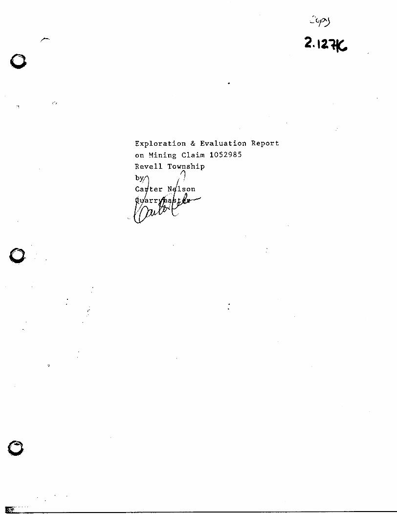
Exploration & Evaluation Report
on Mining Claim 1052985
Revell Township
by
Carter NelsonQuarrymaster
12,
This report is being written for the purpose of
evaluating mining claim 1052985 and is to be
accepted by the mining recorder as assessment
work as a point of view by an expert in the field
of granite exploration and development.
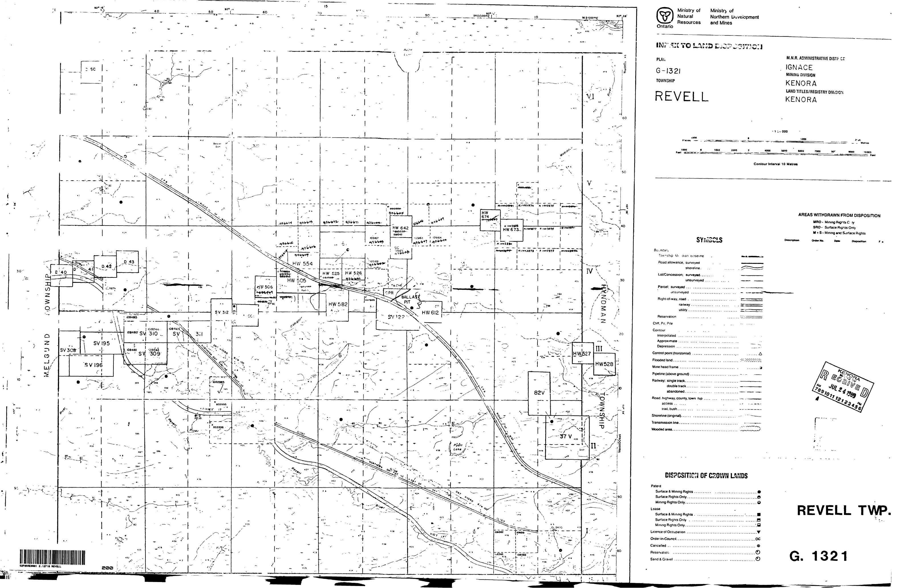
Claim No 1052985
Revell Township
Staked Aug.17/88
5:15 PM
by David Breeze
Recorded Aug.30/88
Transfered Dec.14/88
to Carter Nelson
I am Currently Vice-President of Nelson Monuments
Ltd and President of Nelson Granite Limited which
is the leading stone producer in Ontario. I am also
deeply involved in exploration for this company and
many knowledgable people agree that Nelson Granite
has the potential to become a leading world producer
of granite
My family has been in the granite trade since the late
1800*s and I started to learn my trade as a quarry-
master at the age of 15.
I have done exploration on dozens of granite
formations and have visited producing quarries in
Canada, United States, Germany, India, and South
Africa.
Our operation in Vermilion Bay, Ontario is an
example of our most recent achievement. This is a
granite that most Canadian Producers said had a
very limited potential but after less than 10
years of production, Nelson Granite is suppling the
world market. This granite has a very bright future,
The following commen-fs about nujcriTng claim 10.5-2"9'85
/"' /^ ^' located in Revell Township is to be/treated as
continental information.
Some of the information concerning mining claim
1052985 comes from past exploration done on mining
claim 855995 which is a mining claim that adjoins
the southern boundry. The granite on both mining
claims appears to be identical in colour and
texture.

VEGETATION
TREES:
Mining claim 1052985 is covered with scattered timber
including pine, spruce, alder, and poplar.
SOIL:
Soil conditions range from sand to clay to granite
outcroppings.
WATER:
The Little Wabigoon River runs east to west across
the nothernly part of the mining claim. The water in
the Little Wabigoon River is brackish and uninviting.
Does not appear to support much in the way of fish
stocks.
GULCH:
A gulch runs approximately 30 feet deep to 150 feet
wide and runs from the southwest corner of the
mining claim toward the northwest, ending at the
Little Wabigoon River near the east boundry of the
mining claim.
INSPECTION OF CLAIM 0152985
A full inspection of mining claim 1052985 was done,
but the outcroppings were found only on the southeast
portion of the claim. There are many small
outcropping along the southern boundry that rise less
than two feet above soil. These outcropping are
badly weathered and jointing is close, two feet and
less. It is unlikely this part of the mining claim
could be used for diminional stone.
Along the eatern boundry, between post #2 and Little
Wabigoon River, there are three major outcroppings,
#1, #2, and #3 (see map) and sdow good possibilities
for extraction of diminional stone.
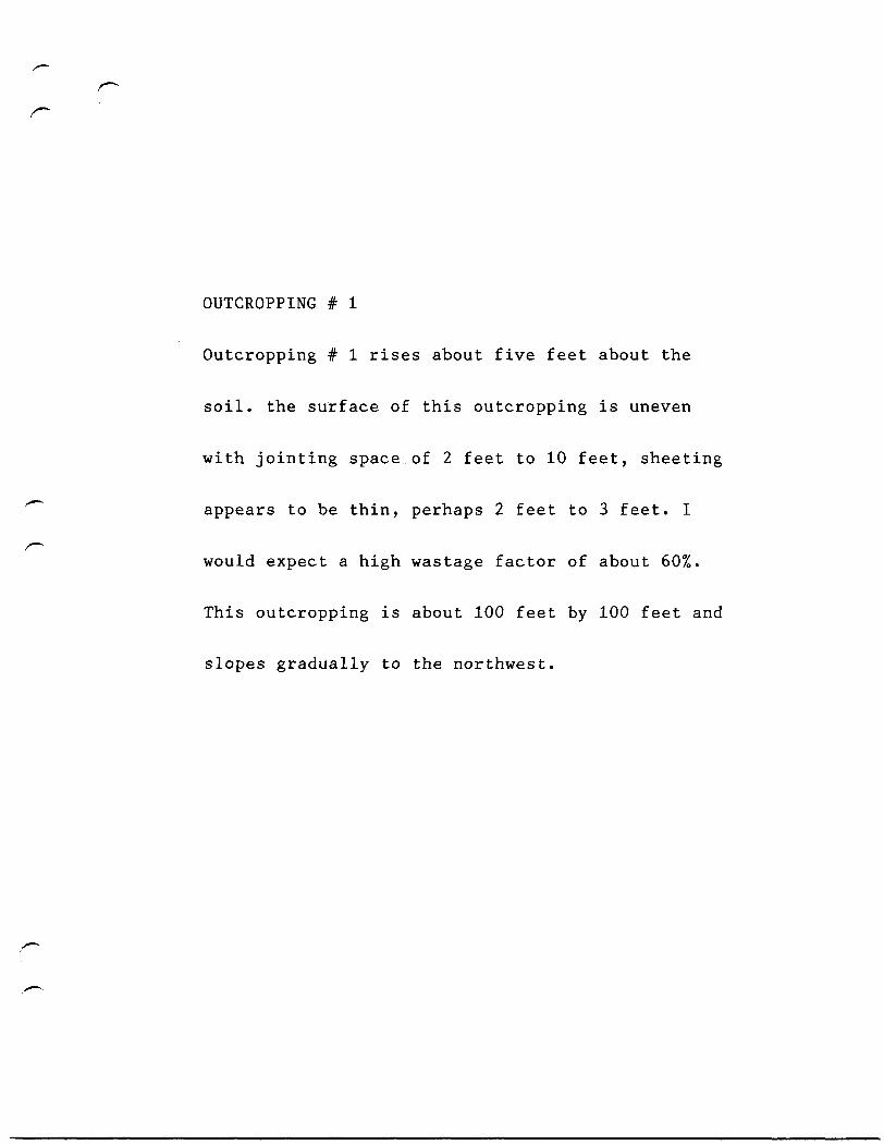
OUTCROPPING # 1
Outcropping # 1 rises about five feet about the
soil, the surface of this outcropping is uneven
with jointing space of 2 feet to 10 feet, sheeting
appears to be thin, perhaps 2 feet to 3 feet. I
would expect a high wastage factor of about 60%.
This outcropping is about 100 feet by 100 feet and
slopes gradually to the northwest.
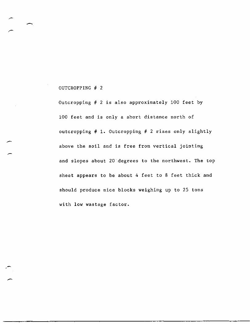
OUTCROPPING # 2
Outcropping # 2 is also approximately 100 feet by
100 feet and is only a short distance north of
outcropping # 1. Outcropping # 2 rises only slightly
above the soil and is free from vertical jointing
and slopes about 20 degrees to the northwest. The top
sheet appears to be about 4 feet to 8 feet thick and
should produce nice blocks weighing up to 25 tons
with low wastage factor.
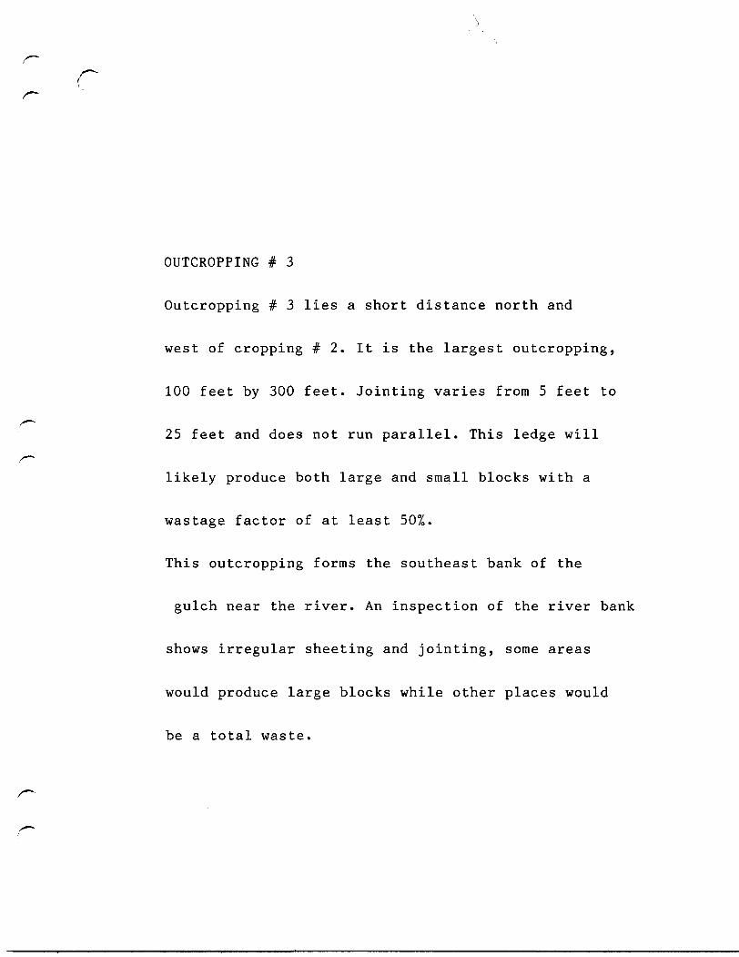
OUTCROPPING # 3
Outcropping # 3 lies a short distance north and
west of cropping # 2. It is the largest outcropping,
100 feet by 300 feet. Jointing varies from 5 feet to
25 feet and does not run parallel. This ledge will
likely produce both large and small blocks with a
wastage factor of at least 50%.
This outcropping forms the southeast bank of the
gulch near the river. An inspection of the river bank
shows irregular sheeting and jointing, some areas
would produce large blocks while other places would
be a total waste.
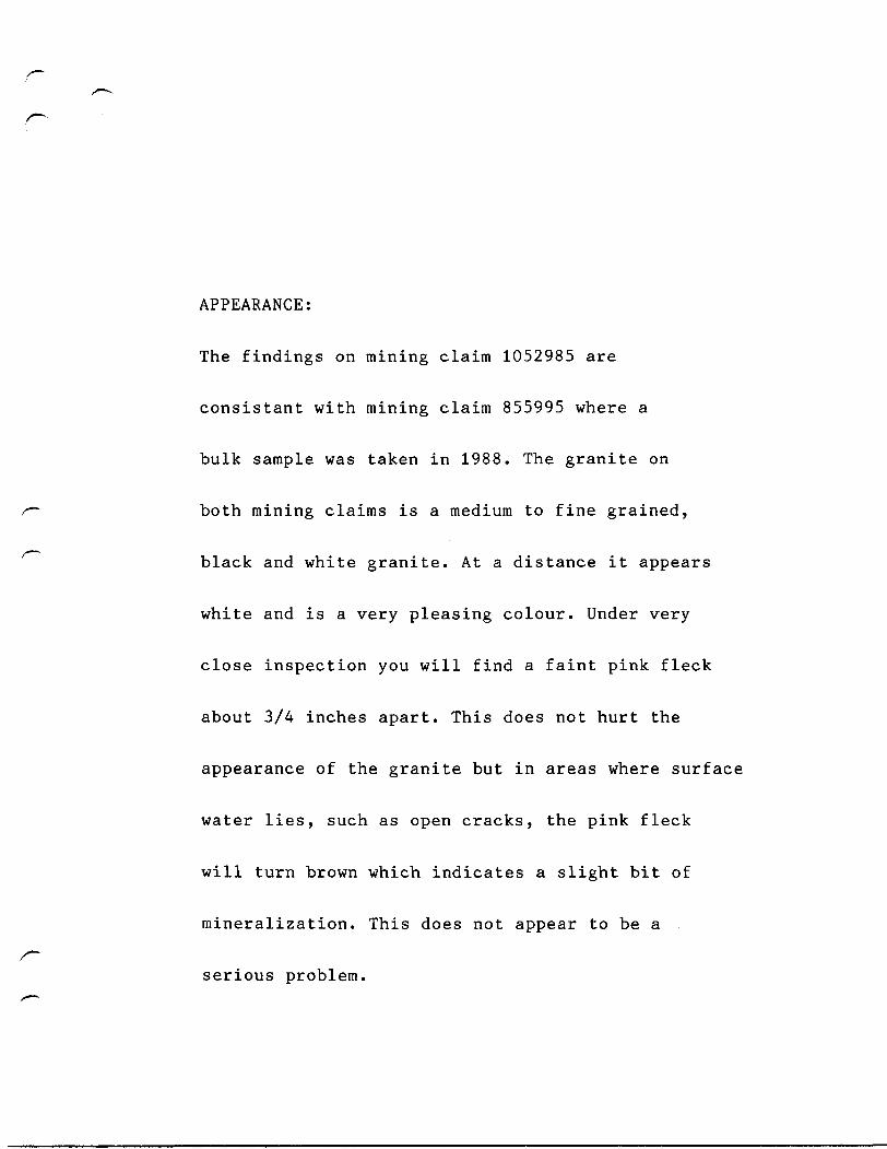
APPEARANCE:
The findings on mining claim 1052985 are
consistant with mining claim 855995 where a
bulk sample was taken in 1988. The granite on
both mining claims is a medium to fine grained,
black and white granite. At a distance it appears
white and is a very pleasing colour. Under very
close inspection you will find a faint pink fleck
about 3/4 inches apart. This does not hurt the
appearance of the granite but in areas where surface
water lies, such as open cracks, the pink fleck
will turn brown which indicates a slight bit of
mineralization. This does not appear to be a
serious problem.
The appearance of this granite is one of its
strong points in the monumental field, it would
be sold as a white granite. While in the
building trade it would be called salt and pepper
granite. Another strong point is that it is one of
strongest granites anywhere, as laboratory test
have proven it is a very very high quality granite
and this makes it a very suitable granite for the
building industrial purposes. (Lab.test enclosed)
This granite splits well when using shims and
wedges, and also with explosives. When using
explosives, because the granite is so hard special
special care must be taken as not to shatter the
stone even when using K-pipe. This granite
saws and polishes nicely and works well with
hand tools. It is suitable for all granite
products except possibly large buildin jobs
when the cost of quarrying is so important.
QUARRY OPERATION:
In order for a quarry to operate in this
formation, the stone would have to sell for
$18.00 to $25.00 per cubic foot. At this
price it will be slow finding its way into the
market place. It might be wise to keep this
quarry at a low producrion for the first few
years to establish production cost and to get a
market established. If a granite finishing plants
are established near a quarry, like this one it
will become profitable much sooner.
SUMMARY:
To summary, in my opinion, the granite is a very
good colour and is a high quality but because of the
formation, production cost are likely to be high.
Also in this area there are shortage labour in
general and few, if any qualified quarry workers
and this fact will increase production cost.
Yes, this quarry should be brought into production
but with a great deal of custion.
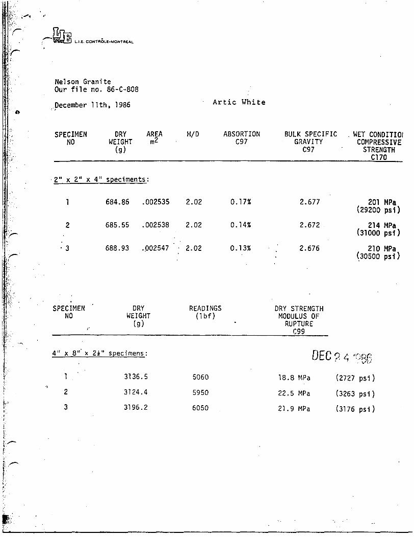
L.I.E. CONTHOLE-MONTBEAL
Nelson GraniteOur file no. 86-C-808
December llth, 1986 Artic White
• I.
;:
SPECIMENNO
2" x 2" x
1
2
3
SPECIMENNO
4" x 8" x
1 '
2
3
DRY AREAWEIGHT m2(g)
4" speciments:
684.86 .002535
685.55 .002538
688.93 ..002547 '
DRYWEIGHT
(g)
2i" specimens:
3136.5
3124.4
3196.2
H/D ABSORTION BULK SPECIFIC WET CONDITIOlC97 GRAVITY
C97
2.02 0.17% 2.677
2.02 0.14% 2.672
2.02 0.13% .' 2.676
READINGS DRY STRENGTH(ibf) MODULUS OF
RUPTURE099
DEC ?. 4 -
5060 18.8 MPa (2727
5950 22.5 MPa (3263
6050 21.9 MPa (3176
COMPRESSIVESTRENGTH
C170
201 MPa(29200 psl)
214 MPa(31000 psl)
210 MPa(30500 psl)
ogg
psi)
psi)
psi )

Quarry Master- Carter Nelson
I am currantly Vice-President of Nelson Monuments
Ltd, Sussex, NB., President of Nelson Granite Limited,
Vermilion Bay,ON., and Vice President of Granite
Exchange, Sussex, NB. I am also shareholder and play
an active part in the day to day operations of the
forementioned companies.
I am a member of Monument Builders of North America,
America Monument Association, Atlantic Canada
Monument Association, and the Quebec Granite Producers
Association. I am also working together with Ted
Coppola of Canital Granite (Manitoba) to organize an
association for granite producers in Northern Ontario,
Manitoba, Saskatchewan, Alberta, and British Columbia
that is to be called Western Canada Granite Producers
Association.
I am also deeply involved in granite exploration for
Nelson Granite Limited in Northern Ontario and Manitoba.
World leading granite quarriers and producers from Italy,
Japan, Finland, Quebec, Minnesota, Vermont, South Africa,
Spain, and Portugal have visited my companys granite
operation and deposites in Northwestern Ontario and they
all agree that we have the potential to become a world
leader in granite production.
I have visited quarry operations in Riviere Pierre,Que.,
Beebe,Que., River Valley,Ont., Havelock, Ont., Alam,Que.,
Jonesport,ME.,Rockland,ME., Chelmsford,MA., North Jay,ME.,
Derbyline,VT., Barre, VT., Wausau,WI., St.Cloud, MN.,
Coldspring, MN., Milbank,SD., Nictar Falls,NS.,
Shelburne,NS., Belfast,South Africa., Rustenburg,South
Africa., and several operations in the Kalman area
in India.
quarry master at the age of 15 years.
Nelson Granite's operation at Vermilion Bay,ON. has
proven to be very successful and is the leading
granite producer in this province. From this operation
we supply pink granite to markets around the world.
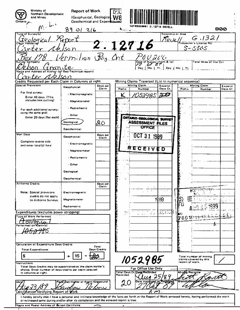
Ministry ofNorthern Developmentand Mines
Ontario
Vt -u-
Report of Work(Geophysical, Geologica Geochemical and Ex pen
DOG
52F89SE8881 2.12716 REVELL900
Type of Survey(s)
Sur veyCpmpan y
Name and Address of Author (of Geo-Technical report)
I Date of Survey (from & to) /9 6> sr i
Day [ Mo. J_ Yr. J DayJ Mo. _[_ Yr.
Total Miles of line CUT
Credits Requested per Each Claim in Columns at right Mining Claims Traversed (List in numerical sequence)Special Provisions
For first survey:
Enter 40 days. (This includes line cutting)
For each additional survey: using the same grid:
Enter 20 days (for each)
Man Days
Complete reverse side and enter total(s) here
Airborne Credits
Note: Special provisions credits do not apply to Airborne Surveys.
Geophysical
- Electromagnetic
• Magnetometer
- Radiometric
- Other
Geological/
Geochemical
Geophysical
- Electronmagnetic
- Magnetometer
- Radiometric
- Other
Geological
Geochemical
Electromagnetic
Magnetometer
Radiometric
Expenditures (excludes power
Days perClaim
$6
Days per Claim
Days perClaim
stripping)Type of Work Performed
Teo/oefiCu- iPerformed on'xilaim(s)
Calc ulation of Expenditure Days Credits
Total Expenditures
$ -i- 15
Total Days Credits
m \£&Instructions
Total Days Credits may be apportioned at the claim holder's choice. Enter number of days credits per claim selected in columns at right.
7,«^
faf<23/o? ^Rot6^
"Cert/f)6ationA/erifying Report
ded H
*4X*
ofder or Agent (Signature)
Mining ClaimPrefix Number
< /0$3ftA56.' " '''i
' • • i
" • -|il7ii
Expend. Days Cr.
3&&
r I^NfAWO OCOLOQICAl. SURVt[ : J' ASSESSMENT iflLES-1 -. OFFICE
|j OCT3119•'I* — — v (
>. • ..-,',-. .
i<
r ; • --'• • • •-
:0""
89
;-CilU
Mining ClaimPrefix Number
1rIj
M
105 W 6fFor Office Use Only _„,-
Total Days Cr. Daw'WecOrded / Recorded \f] il* £.*)/% 9
/) /"\ Date App/qyefl as^necouea2~v ^7$^£;r
V: lr 1r& ;
r
i '
1 - i 1
?;'• - j£ :
1 ' _ — — .- — - —
I \V. -"' '•' _
B) I'.-l .'..--C" A 1^2 5 1939KM _ :. ....,, ,
' Q L1 >' ' • ' • • • ' * •'. i.
ja —p —— ~~—— ——— *-
;
L - . iTotal number of mining claims covered by this report of work.
Expend. Days Cr.
_—
. '
.iit I—— . — >
/
M\rMg Recorder ^sy "™*^*^»^
Br^^^^
"~-— 1 — • —
of Wbrk /? A*7 .1 hereby certify that 1 have a personal or witnessed same during and/or after
Natne and Pojtal Address of (person Certi
and intimate knowledge of the facts set forth in the Report of Work annexed hereto, having performed the work its completion and the annexed report is true.
fvina XT—N- —— ,— ..-.__.-... .-.-.
o
Exploration & Evaluation Report
on Mining Claim 1052985
Revell Township
Sit'
' '""- J ~
'~ ----|-,VVr^
\ \ ' IOB40I3 ' V- v \ ' _ l _ ,__I_- * - «J \ \ p"*"'™' r * * " """
•'._.. - r
1 - --:^^: \ ' • ' / •
S2F»9SE«««1 £.12716 REVELL
^-l'- - '
Ontario
Ministry ofNaturalResources
Ministry ofNorthern Developmentand Mines
*:t TOPLAI,
G-I32ITOWNSHIP
REVELL
M.N.R. ADMINISTRATIVE DISTF CI
IGNACE MINING DIVISION
KENORAUNO TITLES/REGISTRY DIViSIQM
KENORA
•„.. ooo10OO
1000 4000 sooo
1000
tooo 7000 000 10000
Contour Interval 10 Metre*
SYMSCLS
f aian
Road allowance, surveyed shoreline.
Lot/Concession; surveyed........unsurveyed ... ....
Parcel; surveyed ... .............jnsurveyed ..................
Right-of-way, road . ...................railway ............. ... .utility....................
Reservation ....... .. .
Cliff. Pit, Pile
Contour . ... ...Interpolated ... .... ...........Approximate ...... .... ............Depression ... ..... .............
Control point (horizontal) ...... ..........
Flooded land........ ................
Mine head frame ............ ............
Pipeline (above ground) ....................
Railway: single track........ .. .... ......double track....... ...... ......abandoned....... ........ ......
Road, highway, county, town hip .... ...access ......trail, bush..... ... .. .......
Shoreline (original)...... ..................
Transmission line..........................
Wboded area..........................
n OF CROWN LAKDSPatent
Surface & Mining Rights .......... ..........................Surface Rights Only . ....................................... j&Mining Rights Onty ....................................... . ..Q
LoaseSurface & Mining Rights . ...................... ̂ .... '.......•Surface Rights Only . ........ ... ................ ...... JHMining Rights Only.. ............................ . ........ '.B
Licence of Occupation ........................................ .V
Order-in-Council. ............................................ .OC
Cancelled . . ..................... .......................... ®
Reservation ............................................... .(f)
Sand & Gravel ............................... ............... ©
AREAS WITHDRAWN FROM DISPOSITION
MRO- Mining Rigrcs C lySRO- Surface Rig-as OnlyU + S - Mining and Sjrface Rights
OrtwNo. DM DUfMMttion r
r
REVELL T\/VP.
G. 1321