Embed Size (px)
Citation preview
- 1 -
EXPEDITION TWO: AN INTERDISCIPLINARY MARS ANALOG RESEARCH EXPEDITION
TO THE ARKAROOLA REGION, SOUTH AUSTRALIA
R. Persaud*, J.D.A. Clarke†, S.M. Rupert Robles‡, E. Martinez§, F. Karouia**, J. Heldmann††, A. Brown ‡‡, M. Thomas§§, V. Waclawik ***, V. Gostin†††, D. Willson‡‡‡, S.
Dawson§§§, P. Krins ****, S.T. Sklar††††, J. Waldie‡‡‡‡, N. Cutler§§§§ and J. Laing *****
Expedition Two was the second in a series of expeditions to Mars analog locations worldwide under the auspices of the Mars Expedition Research Council (MERC), the Mars Society of Canada, and the Mars Society of Australia. The goals of Expedition Two were fourfold: research, operations, outreach and education. The expedition was constrained within an approximate 100 km radius of Arkaroola in the northern Flinders Ranges in the Australian Outback. There were six main themes to the expedition within the goals: Field Science – Collecting baseline geological and biological data on the field area and its Mars analog significance. Exploration Technology - Trials of the MarsSkin 3 analog Mechanical Counter Pressure suit. Exploration Operations – evaluation of exploration methodologies, data collection and data loggers, and a site database, and selection of the site for MARS-OZ. Human Factors – psychological profiling of an international, multi-disciplinary team of expeditioners, cognitive function, leadership philosophies, and crew social interaction. Outreach – extensive local, national and international interest was generated by web, broadcast and print media. Education – interaction with groups of students from the International Space University’s Summer School Program and undergraduates from the University of South Australia, and the University of Technology Sydney.
* Dept. of Geology, University of Toronto. Email: [email protected]. † Associate, Australian Centre for Astrobiology, Macquarie University, NSW, Australia. Email: [email protected]. ‡ MiraCosta College, Physical Sciences Dept.; also Miramar College, Dept. of Nat. Sciences, San Diego, CA. Email: [email protected]. § California State University at Sacramento, Dept. of Environmental Studies. Email: [email protected]. ** University of Houston. Email: [email protected]. †† NASA Ames Research Center. E-mail: [email protected]. ‡‡ Australian Centre for Astrobiology, Macquarie University, NSW, Australia. Email: [email protected] §§ Geosciences Australia. Email: [email protected] *** Dept. Earth and Environmental science, University of Adelaide. Email: [email protected] ††† Dept. Earth and Environmental science, University of Adelaide. Email: [email protected] ‡‡‡ SEMF Pty Ltd. Email: [email protected] §§§ Australian National University. Email: [email protected]. **** Australian National University. Email: [email protected]. †††† Northern Arizona University, email: [email protected] ‡‡‡‡ BAE Systems, Melbourne, Australia. Email: [email protected]. §§§§ BAE Systems, Melbourne, Australia. Email: [email protected]. ***** School of Business, La Trobe University. Email: [email protected]
- 2 -
TABLE OF CONTENTS INTRODUCTION - 4 -
THE MARS EXPLORATION RESEARCH EXPEDITION SERIES - 5 - ADVANTAGES OF THE ARKAROOLA REGION - 7 -
Geology - 7 - Geomorphology and regolith - 7 - Palaeontology - 7 - Hydrology - 8 - Biology - 8 - Geophysics - 8 - Remote sensing - 8 - Scale of Investigations - 8 - Outreach and education - 8 -
PROGRAM LOGISTICS - 8 - PARTICIPANTS - 9 -
Core expeditioners - 9 - Accompanying expeditioners - 9 - Visiting expeditioners - 10 -
EXPEDITION THEMES - 10 - GEOGRAPHICAL FIELD RESEARCH AREAS - 10 - EXPEDITION RESEARCH PROJECTS - 11 -
Biology - 12 - Geology - 12 - Human Factors - 13 - Exploration Operations - 13 - Exploration Technology - 13 -
OUTREACH - 13 - International Space University - 13 - University of Technology Sydney - 13 - University of South Australia - 14 - Other media - 14 -
RESEARCH PROJECTS: ORIGINAL PROPOSALS AND EXPEDITION FIELD REPORTS - 15 - PROJECT ONE: A Proposal For A Mars Analog Microbial Observatory And The Need For Baseline Biodiversity Studies At MDRS, FMARS and MARS-OZ - 15 - PROJECT TWO: Characterization of Extremophile Population Surrounding Arkaroola using 16S rRNA based Molecular Probes - 22 - PROJECT THREE: Mars Analog Springs and Fluvial Deposits - 24 - PROJECT FOUR: Remote methods for detection of hydrothermal activity in Mars Analog regions, an example from the Mt. Painter District, northern Flinders Ranges, South Australia - 35 - PROJECT FIVE: The evolution and dynamics of desert dunes in the Lake Eyre Basin, South Australia - 39 - PROJECT SIX: Neotectonics of the alluvial fans of the Lake Frome Plains - 40 - PROJECT SEVEN: Arkaroola Mars Analog Database - 42 - PROJECT EIGHT: Social Psychological, Personality and Cognitive Issues Relevant to a Human Mission to Mars - 44 -
PART A: Social Psychological Issues Relevant to a Human Mission to Mars. - 44 - PART B: Leadership and Group Intervention Issues Relevant to a Human Mission to Mars. - 48 - PART C: Neurocognitive Issues Relevant to a Human Mission to Mars - 51 -
PROJECT NINE: Scouting Mars: A Collaborative Methodology for Field Operations and Remote Science - 54 - Introduction - 54 - APPENDIX: REGOLITH-LANDFORM MAPPING FOR THE ARKAROOLA FIELD AREA - 68 -
PROJECT TEN: Astronaut EVA Dataloggers for Scouting Mars - 72 - PROJECT ELEVEN: Mechanical-Counter-Pressure Gloves and Spacesuits for the MarsSkin Project - 75 -
OUTREACH AND EDUCATION - 79 - ISU - 79 - UTS - 79 -

- 3 -
PUBLIC NEWS MEDIA INTERACTIONS - 79 - EXPEDITION ONE MEDIA COVERAGE - 81 - EXPEDITION ONE AND TWO MEDIA COVERAGE - 81 - EXPEDITION TWO MEDIA COVERAGE - 82 - Conclusions about Media Coverage - 82 -
Canadian Publicity and Outreach - 83 - Post-Expedition Canadian Mars Lecture Series - 83 -
APPLICATION OF OUTCOMES TO FUTURE EXPEDITIONS - 85 - ACKNOWLEDGEMENTS - 85 - REFERENCES - 86 -
- 4 -
INTRODUCTION A Mars analog is an environment or situation on Earth with characteristics, in nature or by simulation, for
which there are, or could be, analogous characteristics on Mars. This definition covers both the physical setting of Mars, as well as design considerations for technological challenges and scenarios for human activity. This paper comprises a post-expedition assessment on the degree to which the pre-expedition goals and expectations have been met.
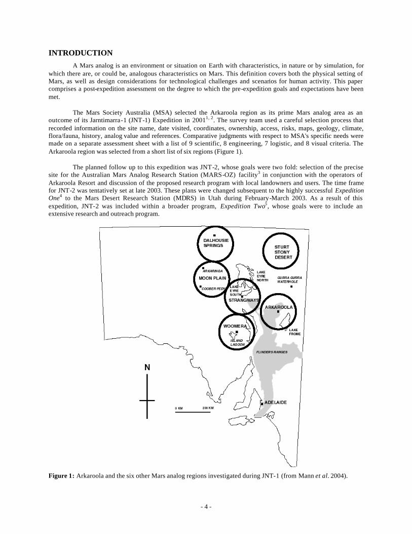
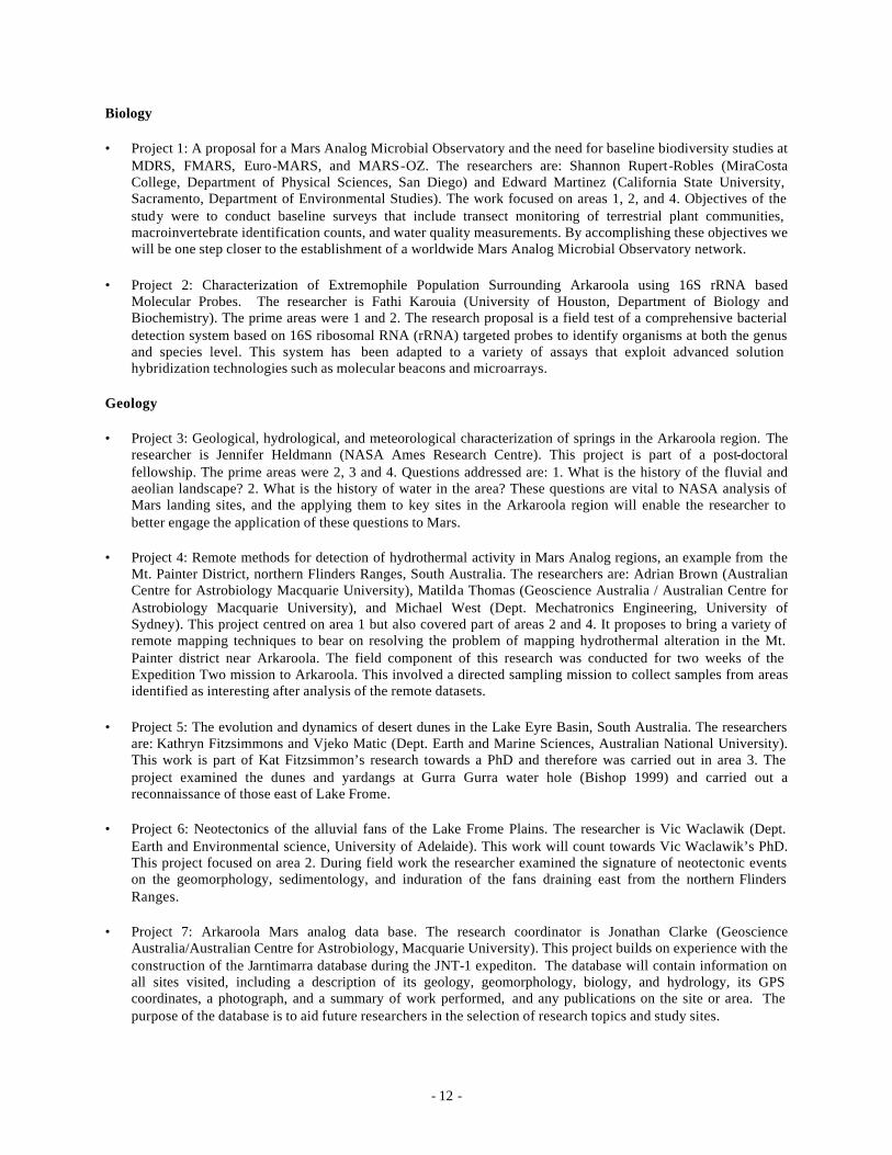
The Mars Society Australia (MSA) selected the Arkaroola region as its prime Mars analog area as an outcome of its Jarntimarra-1 (JNT-1) Expedition in 20011, 2. The survey team used a careful selection process that recorded information on the site name, date visited, coordinates, ownership, access, risks, maps, geology, climate, flora/fauna, history, analog value and references. Comparative judgments with respect to MSA's specific needs were made on a separate assessment sheet with a list of 9 scientific, 8 engineering, 7 logistic, and 8 visual criteria. The Arkaroola region was selected from a short list of six regions (Figure 1).
The planned follow up to this expedition was JNT-2, whose goals were two fold: selection of the precise site for the Australian Mars Analog Research Station (MARS-OZ) facility3 in conjunction with the operators of Arkaroola Resort and discussion of the proposed research program with local landowners and users. The time frame for JNT-2 was tentatively set at late 2003. These plans were changed subsequent to the highly successful Expedition One4 to the Mars Desert Research Station (MDRS) in Utah during February-March 2003. As a result of this expedition, JNT-2 was included within a broader program, Expedition Two5, whose goals were to include an extensive research and outreach program.
Figure 1: Arkaroola and the six other Mars analog regions investigated during JNT-1 (from Mann et al. 2004).
- 5 -
THE MARS EXPLORATION RESEARCH EXPEDITION SERIES
Recognizing the need for a professional, formal research body, members of the Expedition One crew formed the Mars Expedit ion Research Council (MERC) in 2003. This council’s oversight committee is responsible for the peer review of research proposed for the expeditions, the financial resources of the expedition council, and the selection of host institutions that would oversee logistics and public relations related to the conduct of an expedition.
Mars expeditions planned by science-driven space agencies would be of necessity science-driven missions. The building of spacecraft, the transit to Mars, the setting up of base camp, the specific technology used for life support on Mars, and the return to Earth do not comprise the mission. These are necessary components to make the mission happen successfully, but the mission is the scientific exploration of Mars to answer questions of geology, geophysics, climate, biological potential and history. The mission is the science. All the other factors that contribute to accomplishing that mission preceding and succeeding surface exploration operations are not considered by MERC’s Mars Analog Program.
However, the results of our program are tools, knowledge and strategies that will affect these other factors. For instance, a science-driven expedition intending to maximize the science-return will require field operations on the Martian surface for as long as possible – in the case of Mars, this mean conjunction class missions rather than opposition class missions.
Conjunction class missions, such as those proposed in the Mars Direct and the NASA Design Reference Mission scenarios, are long-surface stays, between 550 and 720 days depending on annual orbital variations. Opposition class missions, such as those proposed by Rosaviakosmos (round-trip time being 440 days), due to orbital mechanics are short-duration surface stays in the order of 30-60 days, depending on annual orbital variations.
To maximize the amount of knowledge produced by a science-driven mission, the duration of the surface stay must be maximized. This dictates conjunction-class mission architectures, allowing for 550 to 720 days of exploration. The aim of MERC’s program is not to evaluate mission architectures, but to provide science-driven knowledge of how to make surface operations more efficient, intellectually, physically and socially, in accomplishing its goals. Along the way to determining the output possible within an conjunction class mission architecture, MERC will also determine the output possible within a opposition class mission for comparison.
Mars analog studies are already significantly contributing to the expansion of knowledge about the requirements for human Mars expeditions, such as research in field science, exploration operations, human factors and exploration technology, as well as other areas. There is enough work to do to occupy several programs over many years by several agencies. The assembly of that body of knowledge into scenarios for human activity is yet to be achieved and tested in a holistic expedition simulation, which would not be possible until the metrics of exploration are defined.
These metrics would be used to measure the quality of exploration on the surface of Mars in order to improve it. From a framework of scientific fieldwork, studies into how to achieve that mission need to consider the operational factors, social-psychological factors, and technological factors that affect the field work and the field team.
Simulations which are not holistic because they do not incorporate a field science program, such as those by the Institute for Biomedical Problems in Moscow, are confinement studies applicable to social-psychology research of crews in transit between Earth and Mars with little to do and little reason to interact in productive work. However, it is quite likely that a crew of a Mars expedition will have lots of collaborative pre- landing planning to do as they review their goals, pick research sites, and consider new data from satellites in orbit and robots already on the surface.
This makes confinement studies that do not have a crew collaborating daily towards common goals, performing real science mission planning and analysis, suspect in premise. They still may be useful to develop tools for evaluating crew social-psychology, once the correct premise is incorporated.
- 6 -
To be able to conduct a holistic simulation that will test out all scenarios for scientific exploration over a period of the same range as proposed for Mars expeditions (i.e. 550-720 days), research needs to be done now to define the requirements of each science goal and its human considerations from an operational perspective geared towards maximizing efficiency and defining technological support requirements – what may be called science return optimization.MERC, an international, interdisciplinary body of Mars analog researchers, plans to conduct exactly that program of research at Mars analog sites around the world.
Plans for mission architectures like the NASA Reference Mission do not consider science return optimization. Rather, engineering constraints determine what the scientist-astronauts may do. A better approach would be to conduct research on the requirements for the scientific exploration of Mars, and use them to design exploration strategies that inform engineering decisions and expedition planning. From an operational perspective, we do not yet know how to conduct a Mars expedition so that it maximizes the scientific output.
This research needs to begin now, as the process for learning all we need to discover will take between 15 to 20 years prior to a first human Mars expedition. This timeline was developed in a paper by R. Persaud, “A Systematic Approach to Investigations at Mars Analog Research Stations”.6 Based on 100 questions divided into categories of field science, field operations, field reconnaissance, human factors, remote mission support, exploration-supporting technologies, data analysis, and habitat design features, the analysis described in the paper concluded that the way these 100 questions relate to each other determines how and in what manner they can be answered.
This produces a progressive Mars Analog Program of six 30-day analog expeditions focused primarily on field operations and reconnaissance in the context of field science; evolving into six 90 to 180 day analog expeditions focused on improving exploration technology design (where technology is subjected to rough treatment to test for robustness over long durations and requirements for maintenance, power, support), maximizing data analysis methods (to deal with the quantity of data produced and learn how to work collaboratively with remote mission support), and exploring human factors in more detail (since confinement studies have suggested it takes at least six weeks before serious social problems develop) and finally two to three fully holistic simulations of the same order of duration as proposed conjunction class mission architectures (500+ days), in order to assemble all lessons learned into a workable scenario.
These 100 questions are not claimed to be exhaustive of all possible questions regarding how to design a human exploration program on the surface of Mars, but are of sufficient breadth and scope to provide valid analogies with any question likely to be a factor. With these 100 questions, with this Mars Analog Program, MERC can define the metrics of exploration suitable for evaluating any expedition proposed by any agency. Without this program the possibility will be that expeditions would be planned with systemic problems that would not be found until a crew spends a long duration on the surface exploring Mars – too late to do much about it.
The program considers 15 expeditions (as described above) sufficient to fully define a Mars expedition baseline. The strategy begins by acknowledging that the goal for the last Mars analog expedition, prior to a real Mars expedition being launched, is to conduct a 500+ day simulation testing the strategies and employing the exploration technology developed and defined by the prior analog expeditions. The duration is not important, as what can be learned from a 500-day analog expedition can be extrapolated to a 720-day analog expedition.
Six 30-day expeditions and six 90-to-180-day expeditions would be sufficient to prepare for 500- day expedition simulations. These simulations may be at any of the Mars Society’s Mars Analog Research Stations, or the Antarctic Dry Valleys. The Moon would provide opportunities for some analog research (in field operations, tools, technologies, strategies), but Earth is a better analog to Mars than the Moon (regarding the field sciences). These last long-duration expeditions would require major contributions from several space agencies. Since American, European, and Russian space agencies are considering or have proposed using the Moon as a trial for Mars and beyond, MERC’s research program is well aligned to lead up to those activities. It is a roadmap, which MERC encourages those space agencies to adopt and develop. Assuming one analog expedition per year, or alternatively reasonable amounts of time to prepare for long duration simulations, this program will require 15 to 20 years to complete.
- 7 -
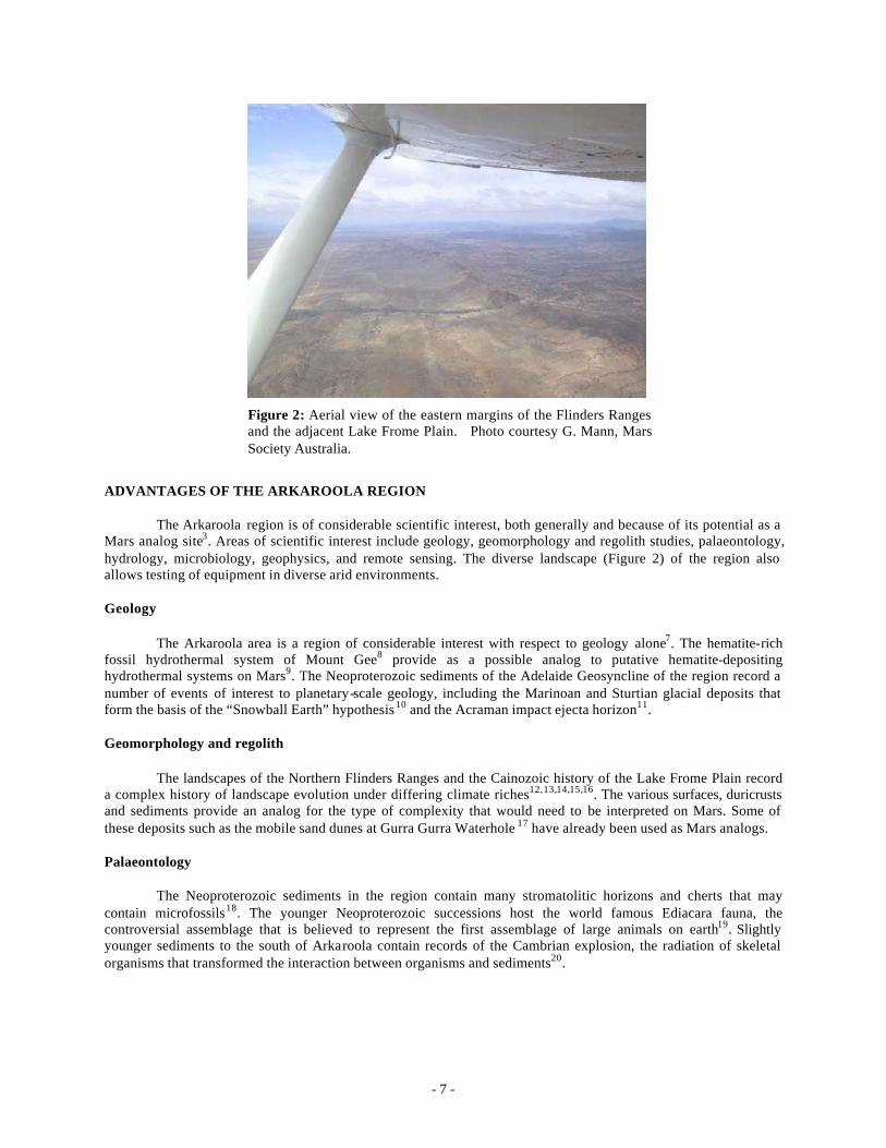
Figure 2: Aerial view of the eastern margins of the Flinders Ranges and the adjacent Lake Frome Plain. Photo courtesy G. Mann, Mars Society Australia.
ADVANTAGES OF THE ARKAROOLA REGION
The Arkaroola region is of considerable scientific interest, both generally and because of its potential as a Mars analog site3. Areas of scientific interest include geology, geomorphology and regolith studies, palaeontology, hydrology, microbiology, geophysics, and remote sensing. The diverse landscape (Figure 2) of the region also allows testing of equipment in diverse arid environments.
Geology
The Arkaroola area is a region of considerable interest with respect to geology alone7. The hematite-rich fossil hydrothermal system of Mount Gee8 provide as a possible analog to putative hematite-depositing hydrothermal systems on Mars9. The Neoproterozoic sediments of the Adelaide Geosyncline of the region record a number of events of interest to planetary-scale geology, including the Marinoan and Sturtian glacial deposits that form the basis of the “Snowball Earth” hypothesis10 and the Acraman impact ejecta horizon11.
Geomorphology and regolith
The landscapes of the Northern Flinders Ranges and the Cainozoic history of the Lake Frome Plain record a complex history of landscape evolution under differing climate riches12,13,14,15,16. The various surfaces, duricrusts and sediments provide an analog for the type of complexity that would need to be interpreted on Mars. Some of these deposits such as the mobile sand dunes at Gurra Gurra Waterhole 17 have already been used as Mars analogs.
Palaeontology
The Neoproterozoic sediments in the region contain many stromatolitic horizons and cherts that may contain microfossils18. The younger Neoproterozoic successions host the world famous Ediacara fauna, the controversial assemblage that is believed to represent the first assemblage of large animals on earth19. Slightly younger sediments to the south of Arkaroola contain records of the Cambrian explosion, the radiation of skeletal organisms that transformed the interaction between organisms and sediments20.
- 8 -
Hydrology
There are a number of hydrological issues that could be studied. These include the hydrology of the Paralana Hot Spring21, the hydrology and hydrochemistry of uranium bearing waters of the Lake Frome Plain, hydrochemistry of the major salt lakes such as Lake Frome, and the mound springs along the eastern margin of Lake Frome 22.
Biology
Numerous opportunities exist for the study of dry land ecology, endolithic and cryptoendolithic organisms and microbiotic crusts. Of particular interest is the presence of radiation resistant extremophiles in the waters of Paralana hot spring23,24. Numerous other occurrences of radioactive minerals occur in the Mount Painter complex21, and these also may provide niches for radiation resistant extremophiles, but are completely unstudied. The extremophile populations of the various salt lakes in the study area are largely unknown. The nature of the biota in ephemeral water bodies25 could also shed light on the dynamics of such systems and how they, and their putative Martian equivalents, might be studied.
Geophysics
Many of the faults in the Arkaroola area are seismically active. One potential research topic would be to establish a local seismometer net to pinpoint the zones of greatest activity. Another project would be the monitoring of radon emissions along faults and fracture systems . Lastly, the different aquifers, including those associated with the radiogenic and mound springs, as well as perched and shallow ground waters, would serve as excellent targets to test a range of geophysical techniques.
Remote sensing
Potential projects include evaluation and comparison of various remote sensing systems for mineral mapping including Aster, HYMAP, and LANDSAT. Ground truthing of remotely sensed data is also important, using instruments such as the PIMA and especially actual XRD analyses of surface mineralogy8.
Scale of Investigations
Unlike other analog sites, such as Devon Island or Hanksville Utah, the selected area consists of an entire region, rather than one spatially constrained site or cluster of sites. Although the Arkaroola analog region was nominally constrained to a radius of 100 km from the site, there are few constraints on vehicles traveling further afield to other areas of interest, such as Sturts Stony Desert1,2. Therefore, compared to other Mars analog sites, the Arkaroola region provides a unique venue for large scale studies, whether of geological or biological systems, or of long range surface reconnaissance and mobility.
Outreach and education
The Arkaroola resort is Australia’s first and largest private nature preserve7. The owners, the Sprigg family, have a long history of scientific research and interest in ecotourism. They are supportive of the establishment of a Mars analog facility and the many visitors to the region provide an excellent opportunity for outreach26.
PROGRAM LOGISTICS
Week 1 August 2-8 Day 1 Drove to Arkaroola from Adelaide, UTS students joined expeditioners on site. Day 2 Orientation Day 3 – 6 Preliminary work (areas a and b) Day 4 ISU interaction. Day 7 Rest day, departing expeditioners left for Adelaide
- 9 -
Week 2 August 9-15 Day 1 – 5 Field work base (area b) and away (a rea e) teams Day 6 Away team returned, new expeditioners arrived from Adelaide Day 7 Rest day, departing expeditioners left for Adelaide Week 3 August 16-22 Day 1 – 5 Fieldwork base and away (areas d or f) teams, Uni. SA joined expedition for 2 weeks Day 6 Away team returned, new expeditioners arrived from Adelaide Day 7 Rest day, departing expeditioners left for Adelaide Week 4 August 23-29 Day 1 – 5 Fieldwork base and away (areas d or f) teams Day 6 Finished up Day 7 Returned to Adelaide
PARTICIPANTS
Core expeditioners
Australian participants: Prof. Vic Gostin (emeritus faculty Adelaide University) (WEEKS 1 & 2) Matilda Thomas (staff Geoscience Australia, Canberra) (WEEK 3) Adrian Brown (grad student Australian Centre for Astrobiology) (WEEKS 1 – 3) Dr. Steve Dawson (fellow Australian National University psychology department) (WEEK 1) James Waldie (Bae Systems/Department of Engineering, University of Melbourne) (WEEK 1) Natalie Cutler (Bae Systems, Melbourne) (WEEK 1 – 2) David Willson (SEMF Pty Ltd, Hobart) (WEEK 1) Guy Murphy (MSA president) (WEEK 1) Phil Krins (Grad Student, Department of Pyschology, ANU, Canberra) (WEEKS 1 – 4) Dr Jonathan Clarke (staff, Geoscience Australia, Canberra) (WEEKS 1 – 4) Steve Jordan (WEEKS 1 – 4) From Canada: Rocky Persaud (University of Toronto) (WEEKS 1 – 4) From the U.S.A.: Shannon Rupert (faculty, Miracosta College) (WEEKS 2 – 3) Dr Edward Martinez (faculty, California State University, Sacramento) (WEEKS 2 – 3) Fathi Karouia (University of Houston) (WEEKS 1 – 2)
Accompanying expeditioners
Australian participants: Vic Waclawik (grad student University of Adelaide) (WEEKS 2-3) Anna Clarke (nursing, heath, Canberra) (WEEKS 3 – 4) Jennifer Clarke (student, Canberra) (WEEKS 3 – 4) Rosalind Clarke (student, Canberra) (WEEKS 3 – 4) Kathryn Fitzsimmons (grad student, ANU earth and marine sciences Canberra) (WEEK 2) Vjeko Matic (field assistant to Kat Fitzsimmons) (WEEK 2) From the U.S.A.: Aurora Rupert (student, San Diego) (WEEKS 2-3)
- 10 -
Visiting expeditioners
Dr. Graziella Caprarelli (faculty University of Technology, Sydney) plus 9 students (WEEK 1) Dr. Mark Bishop (faculty University of South Australia) (WEEK 2)
EXPEDITION THEMES
Expedition Two has the following goals:
• Field Science: Preliminary research into sites geological, biological, and hydrological analog potential of the Arkaroola region. This will provide a foundation for future research programs.
• Field Engineering: Evaluate the performance of the latest development of the MarsSkin (version 3) analog Mars Counter Pressure suit.
• Operations: Perform operational research of significance to field science data logging (using digital photo, voice and text records each stamped with precise time and GPS locations) for assisting the field scientist with mapping and data documentation protocols, develop exploration methodologies, and select the site for MARS-OZ.
• Human Factors: Investigate crew interactions and leaderships in a normal field expedition. This will provide a basis for comparison with future research of crew interactions under varying levels of simulation.
• Outreach: Interviews with web, print, and broadcast media organisations, updates on society web sites.
• Education: Interaction with the International Space University, the University of Technology Sydney and the University of South Australia.
GEOGRAPHICAL FIELD RESEARCH AREAS
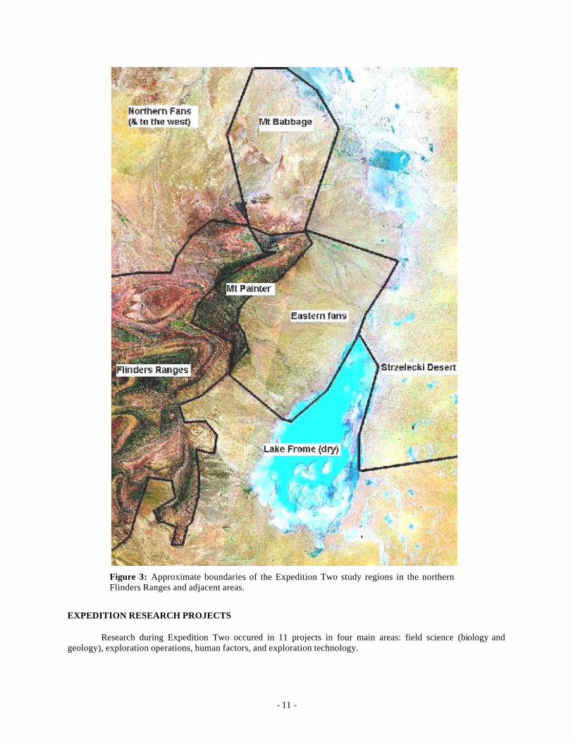
Five areas were visited during Expedition Two (Figure 3). They consist of:
1. The Mount Painter province and Adelaide Fold Belt in the Arkaroola area. This area features radiogenic hot springs, weathered uranium (and other metals) prospects, the Cambrian-Precambrian boundary, Acraman impact layer, Proterozoic glacials, and stromatolite horizons.
2. The eastern fans. These drain from the northern Flinders ranges and have deposited a range of both modern and relict fans and their associated drainage systems. These discharge into the large playa of Lake Frome. Associated with these deposits are localized minor dunes.
3. The Strzelecki Desert. This is a major sand sea of longitudinal dunes. At Gurra Gurra waterhole on Strzelecki Creek there are both aeolian erosional features (yardangs) and crescentic dunes that have been used as a Mars analog. Also in the area are ephemeral rivers, evidence of high lake level shorelines, salt pans, gibber plains, and several mound springs.
4. The Mount Babbage Inlier. This is the northern- most end of the Flinders Ranges and features four or five clusters of mound springs, fans, excellent exposures of glacialmarine Cretaceous, duricrusts, and an exhumed Mesozoic landscape.
5. Northern fans and surfaces. This area consists of deposits formed by drainages flowing north and west from the Flinders Ranges. Features of interest include modern and relict fans and surfaces, duricrusts, gibber plains, sand dunes, and floodouts.
- 11 -
Figure 3: Approximate boundaries of the Expedition Two study regions in the northern Flinders Ranges and adjacent areas.
EXPEDITION RESEARCH PROJECTS
Research during Expedition Two occured in 11 projects in four main areas: field science (biology and geology), exploration operations, human factors, and exploration technology.
- 12 -
Biology
• Project 1: A proposal for a Mars Analog Microbial Observatory and the need for baseline biodiversity studies at MDRS, FMARS, Euro-MARS, and MARS-OZ. The researchers are: Shannon Rupert-Robles (MiraCosta College, Department of Physical Sciences, San Diego) and Edward Martinez (California State University, Sacramento, Department of Environmental Studies). The work focused on areas 1, 2, and 4. Objectives of the study were to conduct baseline surveys that include transect monitoring of terrestrial plant communities, macroinvertebrate identification counts, and water quality measurements. By accomplishing these objectives we will be one step closer to the establishment of a worldwide Mars Analog Microbial Observatory network.
• Project 2: Characterization of Extremophile Population Surrounding Arkaroola using 16S rRNA based Molecular Probes. The researcher is Fathi Karouia (University of Houston, Department of Biology and Biochemistry). The prime areas were 1 and 2. The research proposal is a field test of a comprehensive bacterial detection system based on 16S ribosomal RNA (rRNA) targeted probes to identify organisms at both the genus and species level. This system has been adapted to a variety of assays that exploit advanced solution hybridization technologies such as molecular beacons and microarrays.
Geology
• Project 3: Geological, hydrological, and meteorological characterization of springs in the Arkaroola region. The researcher is Jennifer Heldmann (NASA Ames Research Centre). This project is part of a post-doctoral fellowship. The prime areas were 2, 3 and 4. Questions addressed are: 1. What is the history of the fluvial and aeolian landscape? 2. What is the history of water in the area? These questions are vital to NASA analysis of Mars landing sites, and the applying them to key sites in the Arkaroola region will enable the researcher to better engage the application of these questions to Mars.
• Project 4: Remote methods for detection of hydrothermal activity in Mars Analog regions, an example from the Mt. Painter District, northern Flinders Ranges, South Australia. The researchers are: Adrian Brown (Australian Centre for Astrobiology Macquarie University), Matilda Thomas (Geoscience Australia / Australian Centre for Astrobiology Macquarie University), and Michael West (Dept. Mechatronics Engineering, University of Sydney). This project centred on area 1 but also covered part of areas 2 and 4. It proposes to bring a variety of remote mapping techniques to bear on resolving the problem of mapping hydrothermal alteration in the Mt. Painter district near Arkaroola. The field component of this research was conducted for two weeks of the Expedition Two mission to Arkaroola. This involved a directed sampling mission to collect samples from areas identified as interesting after analysis of the remote datasets.
• Project 5: The evolution and dynamics of desert dunes in the Lake Eyre Basin, South Australia. The researchers are: Kathryn Fitzsimmons and Vjeko Matic (Dept. Earth and Marine Sciences, Australian National University). This work is part of Kat Fitzsimmon’s research towards a PhD and therefore was carried out in area 3. The project examined the dunes and yardangs at Gurra Gurra water hole (Bishop 1999) and carried out a reconnaissance of those east of Lake Frome.
• Project 6: Neotectonics of the alluvial fans of the Lake Frome Plains. The researcher is Vic Waclawik (Dept. Earth and Environmental science, University of Adelaide). This work will count towards Vic Waclawik’s PhD. This project focused on area 2. During field work the researcher examined the signature of neotectonic events on the geomorphology, sedimentology, and induration of the fans draining east from the northern Flinders Ranges.
• Project 7: Arkaroola Mars analog data base. The research coordinator is Jonathan Clarke (Geoscience Australia/Australian Centre for Astrobiology, Macquarie University). This project builds on experience with the construction of the Jarntimarra database during the JNT-1 expediton. The database will contain information on all sites visited, including a description of its geology, geomorphology, biology, and hydrology, its GPS coordinates, a photograph, and a summary of work performed, and any publications on the site or area. The purpose of the database is to aid future researchers in the selection of research topics and study sites.
- 13 -
Human Factors
• Project 8: Social Psychological and Leadership and Group Intervention Issues Relevant to a Human Mission to Mars. The researchers are: Steve Dawson & Phil Krins (School of Psychology, Australian National University), Nishi Rawat (Department of Emergency Medicine, Johns Hopkins University Hospital, Baltimore), and Sheryl Bishop (University of Texas Medical Branch, Galveston). The project is not area specific but draws on experience during Expedition One in Utah. It will investigate the impact of group and sub-group identity and goal alignment on motivation, effort to achieve group goals, and effective communication both within a particular group and between subgroups (including "mission control"). There will also be a number of personal well-being measures included (e.g., stress, mental health). In addition to this there will be a number of measures, which will attempt to assess which self categorizations are utilized by individuals in the course of a day. Other issues to be investigated will include group polarization and ostracism.
Exploration Operations
• Project 9: Scouting exploration methodologies study (SEMS) to optimize field science with remote collaborations. The researchers are: Stacy Sklar (Dept of Geology, Northern Arizona University), and Rocky Persaud (University of Toronto Department of Geology). This project is not area specific.
• Project 10: Field science, field mapping and scouting time/motion operational studies using EVA data-logging functional prototypes. This project is led by Rocky Persaud (University of Toronto, Dept. of Geology). This project is not area specific. Note Projects 9 and 11 were often conducted together.
Exploration Technology
• Project 11: MarsSkin 3: its validity as an analog MCP suit. The researchers are: James Waldie and Natalie Cutler (BAE Systems). This project is not area specific, as the MarsSkins was used in all areas. This version of the MarsSkin included lessons from development of version 2 during Expedition One to Utah. It featured new inner and outer compression suit, a new bubble helmet, and a new back pack for the associated ventilation and electronic systems.
OUTREACH
In addition to the above science and engineering projects there were a number of outreach and education programs that formed a key part of Expedition Two. These include programs with the International Space University (ISU), University of Technology Sydney (UTS), and the University of South Australia (USA).
International Space University
In phase 1 Expedition Two was joined by a group of faculty and students from the ISU. The ISU were holding their annual Summer School Program (SSP) for 2004 in Adelaide. The SPP visited the Arkaroola region for three days and had the Mars analog significance and the Expedition Two research program explained to them in the field. Jonathan Clarke was the prime link with the SSP. However, a number of individual expedition members gave lectures and demonstrated aspects of their work.
University of Technology Sydney
A group of geology students for the UTS also interacted with the expedition during phase 1. Their interest was primarily in the geological and biological significance of the area and how research in these disciplines can better facilitate understanding of Mars and possible abodes for life elsewhere in the solar system. Expedition members guided the UTS students to sites of specific interest without interfering with other research activities. The principle link to them was Jonathan Clarke but, as with the ISU, several expedition members lent their time and expertise to the students.

- 14 -
University of South Australia
A group of environmental science students from the USA interacted with the expedition during phases 3 and 4. These student’s prime focus was on the environment of the northern Flinders Ranges and adjacent areas. Their interest was therefore in the baseline data being collected on the environment, and only secondarily in the analog potential. Dr. Mark Bishop from the USA joined the expedition and managed this aspect of the education and outreach program.
Other media
Lastly there were many opportunities for outreach through the extensive print, web and board media interest that was shown in the expedition. MSA’s Publicity director, Jennifer Laing, coordinated these opportunities in Australia, with assistance from MSC’s Communications Director, Reyna Jenkyns, in Canada. Information about the media coverage of Expedition Two is described in a later section.
- 15 -
RESEARCH PROJECTS: ORIGINAL PROPOSALS AND EXPEDITION FIELD REPORTS
The following sections recount the original proposals for all Expedition Two research projects, and highlight the field reports for some of them. Additional results will be published in peer-reviewed journals or as invited papers for technical volumes in the future. One such volume is Mars Analog Studies (editor J.D.A. Clarke), to be published in 2005 or 2006 by Univelt Inc. as a volume in the Space Science & Technology Series for the American Astronomical Society.
PROJECT 1: A Proposal For A Mars Analog Microbial Observatory And The Need For Baseline Biodiversity Studies At MDRS, FMARS and MARS-OZ
Edward Martinez and Shannon Rupert Robles Introduction
The (U.S.) National Science Foundation has acknowledged the value of studying microbial ecology, and to that end, has instituted a program of research devoted to the development of microbial observatories. This program was designed to develop a network of sites all working toward the discovery of unique microorganisms and the study of the diversity and ecological processes of microorganisms in various ecosystems. In addition, these microbial observatories each follow an established long-term ecological research (LTER) program, while allowing for additional research specific to the environment being studied4. The Mars Desert Research Station (MDRS) in the United States, Flashline Station (FMARS) in Canada, MARS-OZ in Australia and the future EuroMARS in Iceland give us the unique opportunity to develop a worldwide microbial observatory. This observatory would be based on ecological principles and use the same research criteria as other established microbial observatories, within the framework of Mars analog environments27. Current ecosystems can provide models for possible extinct or extant Martian ecosystems. Since development of these methodologies on Mars will not be easy, it is best to develop methodologies for life detection here on Earth. Prior to our exploration of Mars, there are many things on Earth that can teach us about possible life on Mars. Therefore, hypotheses based on Earth analogs are valuable.
However, most established microbia l observatories are site specific. Previous studies have demonstrated that plant and aquatic macroinvertebrate communities are bioindicators of total diversity. Thus the development of universal methodologies based on indices developed from these two main biological ecosystem components is valid for the determination of biodiversity. Therefore, before developing a single microbial observatory encompassing all of the Mars Analog Research Stations, we first need to measure the biodiversity at each location. In order to better determine the feasibility of linking all Mars analog sites into a single unified Microbial Observatory for study, we propose that a baseline biological survey and calculation of biodiversity indices at each site be conducted.
Proposed research The ultimate goal of our study is to develop universal methodologies for biological research conducted at
Mars analogs worldwide. Objectives of the study are to conduct baseline surveys that include transect monitoring of terrestrial plant communities, macroinvertebrate identification counts, and water quality measurements. By accomplishing these objectives we will be one step closer to the establishment of a worldwide Mars Analog Microbial Observatory. Consequently, this would allow for collaborative biological projects, such as microbial taxonomy and LTER studies, at all sites. Even though the locations for MDRS, FMARS and MARS-OZ were selected based on their geological, and not biological, analogous characteristics, we believe that a baseline biodiversity study is needed to provide researchers information on biological richness and equitability at the macroscale level, which can then be applied to processes at the microscale level.
Following the below methodology we will determine the biological diversity of terrestrial plant and aquatic macroinvertebrate communities at various geomorphologically similar areas at each research station. Surveys were conducted at MDRS in May, and will be conducted at FMARS during this rotation, then at MARS-OZ in August 2004. Research dates for EuroMARS are still to be determined.
Previous Research Microbial studies related to the proposed project were started two years ago. During the 2002 field season
at MDRS, a project studying the distribution of microbial communities based on water availability was instituted28.

- 16 -
Soil samples were classified as either wet, meaning they were collected from places where water persists (washes, run-off channels and ephemeral basins), or dry, meaning where water does not persist (escarpments and sloped terrain). Incubation of samples using soda lime as a measure of microbial respiration demonstrated a significant difference in carbon dioxide output between treatments. Wet samples appeared to contain more microbial life than dry samples, based on this measure. This suggests that it is possible to quantify microbial richness across treatments, and that more microorganisms persist during the dry season in areas where water lingers longest. We applied the requirements used to assess the longterm distribution patterns of microbial life at established microbial observatories to our study. This work was continued and expanded in 2003 by the science teams of Expedition One. The resulting data represent the equivalent of a four-month intensive field study4. The results of this work are still being analyzed. Preliminary analyses suggest that microbial richness is significantly dependent on water and water persistence is significantly dependent on soil type (and not microhabitat, as was the assumption in the prior year). In addition, delayed growth (up to one month) of cultured samples in several microbial groups suggests that microbes have adapted to these environmental constraints. Due to the success of these studies we suggest that they should be continued at all Mars analog stations. In order to accomplish this, baseline measures of biological diversity, both spatial and temporal, must be calculated. Only then can data be combined to provide our proposed universal methodologies.
Mars analog sites The Mars Society initiated the Mars Analog Research Station Project in 1998. One of its goals was long
duration geological and biological field exploration conducted in the same style and under the same constraints that will be encountered when humans first travel to Mars. The rational for the selection of the four proposed sites for the stations, Devon Island in Nunavut Territory, Canada (where FMARS is located), Wayne County, Utah, U.S.A. (MDRS), the Australian Outback (now near Arkaroola in the North Flinders Ranges of South Australia) (Mars-Oz) and Iceland (the future EuroMars), were that each provided excellent geological and operational analogs. The Canadian site was chosen because it has at its center an ancient impact crater and is a polar desert. Australia was chosen because it has fossil-containing deserts that date from the time when we believe the surface of Mars held water. Iceland was chosen because its basaltic and geothermal areas most closely resemble where we believe extant life may be found on Mars. Interestingly, the Utah site was selected for its ease of access and physical resemblance to Mars, and was originally slated as a testbed for equipment and isolation experiments29. As mentioned before, none of the four, with the possible exception of Iceland, was selected based on biological characteristics.
There is one common thread, however unintentional, in the initial selection process that makes a worldwide Microbial Observatory possible. Cryptobiotic crusts, found worldwide, are abundant at all sites and constitute the majority of ground cover in some areas associated with each site. Biologically, up to 80% of the living ground cover is cryptobiotic crust in nature, which consists of cyanobacteria and its associated green algae, moss and lichen. The cyanobacteria help maintain soil stability and moisture and assist in the germination and growth of the area’s native and non-native plant species. These crusts are very fragile and are easily damaged by human and livestock intrusion, both of which are a problem at MDRS and possibly MARS -OZ. In addition to these cryptobiotic crusts, there are non-organic structures called desert varnish that are of great interest biologically, as they are believed to be fossilized forms created due to biological activity30. Within these Mars analog sites we selected areas of interest to conduct our proposed biodiversity study.
Biodiversity study sites for MDRS, FMARS, and MARS-OZ Based on each Mars analog’s geomorphology, stream order and elevation, various streams were selected
for our study. Plant survey sites will be determined based on the selection of stream sampling sites.
At MDRS, we completed our surveys along three of the area’s permanent watercourses: Muddy Creek, Salt Creek and the Fremont River. Muddy Creek, a third order stream, was surveyed in two places: below the confluence with Salt Creek and above the confluence with the Fremont River. Salt Creek, a first order stream, was surveyed almost at its spring source in Salt Wash, and again just above the confluence with Muddy Creek. The Fremont River, also a third order stream, was sampled just east of the turnoff to MDRS at Highway 24 and again directly south from Factory Butte.
Fifty six aquatic invertebrate samp les were collected from the above streams. Of the 56 about 50% have been sorted in the lab. Initial assessment indicates low benthic invertebrate diversity as well as low abundance.
- 17 -
Taxonomic identifications of the organisms have not been completed. Plant surveys conducted were not completed and therefore, further work is needed.
At FMARS, nine streams were sampled: FMARS River (second and third orders), HMP Creek (first and second orders), Snowy Creek (first order), Hinsa River (second order), No Man River (third order), Little Comet Creek (first order) and Seven of Nine Creek (first order).
A total of 75 aquatic invertebrate samples were collected and 50 were sorted in the FMARS lab. Taxonomic identification of the organisms has not been started. A preliminary assessment of the macroinvertebrate samples indicates a low diversity. Very few organisms were found and it is believed to be due to the limited amount of carbon falling (organic matter such as leaves etc.) into the stream however, further assessment is needed. Plant diversity was also low. A total of nine different species were found and documented.
At MARS-OZ, our goal is to sample at least three creeks from their headwaters to the lowlands. By doing this, we would have sampled first through third order streams at various elevations (lowland = 150 m, highlands = 600 m). This will allow us to compare first order streams (highland to highland) and third order streams (lowland to lowland) and the surrounding vegetation.
Materials and Methods Preliminary identification of sampling locations was conducted using topographic maps. Once actual
sampling locations are established, GPS coordinates and site photo-documents will be taken. In addition, water quality measurements will be recorded for each sampling location prior to macroinvertebrate sample collection.
• Using a water quality data logger and/or water quality meters we will record the dissolved oxygen concentration, pH, temperature and conductivity of each riffle habitat. These measurements are taken at the lowest riffle sampled at each reach.
Aquatic macro-invertebrate collection and identification will be conducted using the following method and all sampling locations will consist of riffle habitats:
1) A 100 m reach of the stream is identified and three riffle habitats are randomly selected for each sampling location. The reach can be of greater length if riffle conditions dictate.
2) From the randomly selected riffles up to 3 sub samples (depending on the width of the stream) of aquatic invertebrates are collected across the stream channel.31
3) Samples are collected using a Surber-square stream sampler. 4) Sample is transferred to a labeled sampling bottle and preserved with 95% ethanol. 5) Steps 1-5 are repeated for each riffle habitat at each sampling location. 6) Sorting and identification of aquatic macroinvertebrates is conducted in the laboratory using a dissection
microscope and the identification key of Merritt and Cummins.32 7) The Shannon Wiener index and Simpson’s index are used to calculate biodiversity indices that are relative
measures of richness and equitability.33 8) The % similarity between sampling locations is calculated following a protocol34 whereby the family biotic
index (FBI) is first calculated for each sampling location and used to calculate % similarity as follows in this example:
% similarity = ( FBI of first order site A/FBI of first order site B) x 100
Significant differences between sites will be determined by calculating a T-test at alpha = 0.05 using the FBI.35
Plant distribution and identification will be conducted using the following method and is completed within a 50m radius of each aquatic sampling location at the same time, or within the same week, that the stream is sampled.
1) From the middle of the lowest sampling riffle at each reach, four random points, generated from 50 m radius/360 degree random numbers tables are identified as the starting points for transects.
- 18 -
2) The transects are run in all four cardinal directions. Plant counts and identification are completed using a drop rod every 5 m along transect lines run for 25 m out from each randomly selected point in the cardinal directions (N, S, E, W). Data are recorded in a field notebook.
3) Unidentifiable plants are photographed for later identification in the lab. None are collected. 4) A plant check list is developed for all plants within the area. 5) The Shannon Wiener index, Simpson’s index and Habitat Suitability index are used to calculate biodiversity
indices that are relative measures of richness and equitability. Expected Outcomes And Significance
The ultimate goal of our study is to develop universal methodologies for biological research conducted at Mars analogs worldwide. The benefits of conducting this study, beyond creating a baseline biological survey at each site, are three fold: (1) To develop methodology and conduct the surveys that will determine the indices at these three sites, (2) the developed methodology can then be applied to other Mars analog sites and (3) if we determine that these sites (MDRS, FMARS, MARS-OZ and EuroMARS) are biologically similar, scientific assumptions and methodologies can be applied to all three Mars analog sites. For example, in an earlier study we determined that the soil moisture content at MDRS correlated to soil composition and not to the proximity of a water source. If our determined indices are statistically similar we can then assume with some degree of confidence that this will also be the case at MARS-OZ, FMARS and EuroMARS.
The current Mars analog sites were chosen based on their geology and extreme environments. However, we recognize that human activities, water quality, climate, and evolutionary adaptations of the biota at these various sites may influence differences in biodiversity. Therefore, in a scenario opposite to the one outlined above, our determined diversity indices may indicate that the sites are not biologically similar. Consequently, the methodologies developed by the proposed study may not be used as indicated in (3) above. However, if this is the case, we still believe that data provided by this study are valuable in the sense that we will have determined that one or more stations are sitespecific. Therefore, each site may require its own methodologies, which may also be the case on Mars. Additionally, the development of these site-specific methodologies can be used as alternatives to the proposed universal methodologies.
Field Notes: We arrived at Arkaroola on 8 August 2004. The following day we began our introduction to the area by
consulting with the ExTwo geologists and the Arkaroola Reserve landholders. We learned that a six year drought has left most of the creeks in the area dry and the only water available is in the form of springs and/or water holes. We located new sites (water sources) using topographic maps. After visiting one of the sites we modified our collection methodology to a procedure better suited for collecting invertebrates in pools. No other part of our methodology was changed. Analysis of soil samples at each collection site using a PIMA was the only addition to our methods. Complete identification and analysis of macroinvertebrate samples and plant surveys will be done at our home institutions.
Site One: Paralana Hot Springs Sampled: 10-11 August 2004 GPS: 54 J 0349937 6660787 (WGS 84) Elevation: 218 m
Our first site was Paralana, a radioactive hot spring. Radiation levels at the spring, while approximately three times background, are not extremely dangerous, and the setting is quite beautiful. The spring consists of two pools, surrounded by rock. The smaller pool is the hottest in terms of both temperature and radiation levels, while the larger of the two pools contains a considerable amount of algae which lies in various thick and crusted mats both under and on top of the water. The water flows out of the spring and down a small stream which is about a meter wide and choked with brilliant green algae intermittently. This stream winds through a thick stand of red gum, white tea-tree and other vegetation favoring a wet habitat. We found a trend of decreasing temperatures and radioactivity levels as we went down stream from the hot spring. While we found no immediate evidence of macroinvertebrates in the first collection site, which was closer to the spring’s source; we did find some chironomid and dragonfly larvae in the second sample. The plant survey was completed at the furthest downstream site. The site was dominated by red gum and plants whose main habitat is along water courses. The area did not appear to be overgrazed nor disturbed by livestock or wildlife, which is unique among waterholes and springs in the area.
- 19 -
Site Two: Arkaroola Springs Sampled: 11 August 2004 GPS: 54 J 0349869 6644509 (WGS 84) Elevation: 131 m
The Arkaroola Spring is in a spectacular setting, at the base of red quartzite cliffs and surrounded by conglomerate boulders of grey and red under stately red gum trees. There were also numerous dead kangaroos all around the waterhole, which marred somewhat our enjoyment of the area. Our understanding of the dead kangaroos is that they had dehydrated from the drought and lack of water in the area. By the time they found a water source, their condition forced them to drink water very quickly thereby not allowing their body to adjust, causing death. We found some chironomids, beetles, and water boats in the sample taken from the waterhole. The plant survey was complicated by the heavy overgrazing surrounding the waterhole. Much of the edible vegetation was drastically damaged which made identification of the plants even more difficult, since the presence of flowers and/or fruits assists in the identification process. Nevertheless, our plant survey went as planned and the plants in the area were those consistently found at most of our sites. We also saw an echidna in the area.
Site Three: Noodulanoodula Waterhole Sampled: 12 August 2004 GPS: 54 J 0335297 6649749 (WGS 84) Elevation: 369 m
The Noodulanoodula Waterhole site is composed of three successive waterholes within a 400 meter reach. All three waterholes are surrounded by high cliffs dotted with cypress pine. Red gum dominates the riparian areas. The upper two waterholes were mostly covered with mats of algae and were fairly shallow (about 0.5 m). The third waterhole water hole was deeper (about 1.5 m) and did not have any algal mats and was clearer than that of many of our sites. Substrate was composed of angular gravel of 5 cm in diameter. This waterhole was colder than any other waterhole we sampled, possibly because it is shaded most of the day and deeper than most other water sources. We collected hundreds of chronomids, some water boats and dragonfly larva. This was one of our favorite waterholes.
Site Four: Munyallana Spring Sampled: 13 August 2004 GPS: 54 J 0344868 6630546 (WGS 84) Elevation: 130 m
This spring consisted of a series of very small pools. Pools are very shallow with sand and gravel substrate about 4-6 cm diameter. Presence of cows and kangaroos was very evident (odor, tracks, droppings and sightings). Black flies, water boats, and chironomids were seen moving about on the bottom substrate. We sampled two of these small pools. The soils surrounding the pools were very saline and a salt crust was visible on the surface; however, this did not seem to affect the plant diversity, as the plants found here were consistent with what we found at other sites. This site was also right on the main road, which may have an effect on its overall biodiversity.
Site Five: Nepouie Spring Sampled: 14 August 2004 GPS: (cold pool) 54 J 0342418 6627953 (WGS 84) Elevation: 134 m
Nepouie Spring is an amazing place, situated in a notch cut through uplifted ancient bedrock which includes Nepouie Peak, a sacred site. The spring is composed of two very different pools, and is surrounded by spectacular stromatolites and lush vegetation. The first pool contained cold water (14.5 degrees C) and appeared to be a depression in the ground that reached the groundwater water table. This pool contained lots of algae and substrate was composed of sand and gravel. The second pool had a much higher water temperature (27 degrees C) therefore, appeared to be coming from much deeper in the Earth. The water from the cold pool flowed into the warm water pool thereby creating a flowing stream. Most small pools within the flowing stream had small fish. We sampled at the pools and then went further downstream for additional samples. The downstream flow was greater here than at any other site. On- site inspection of the samples indicated a diverse population of organisms within the pools and stream sampling locations. This water source appears to be used by myriad wildlife; we saw emu (father and three babies), a cow, goats, and many kangaroo. Additionally, horse tracks were seen at the edges of the water pools. Nepouie is a wonderful place to spend the day.
- 20 -
Site Six: Black Spring Sampled: 16 August 2004 GPS: 54 J 0350344 6657575 (WGS 84) Elevation: 165 m
Black Spring is a very small waterhole that is shaded most of the day by the surrounding red gum and wattle trees. Radioactivity in the area is slightly above background level. Substrate was composed of organic matter, sand and small angular gravel. Some reed grass was growing at the edges of the pool. Some clams, and chironomids were observed in the small shallow pool. In addition, the pool contained tadpoles, which we did not disturb. Only one sample was taken at this site. The area was very shady and appears to provide water and shelter for the wildlife. Another waterhole, slightly lower in elevation, was present at this site however it was completely overgrown with cattail and therefore was not sampled. This site was unique in that is was right next to the upland area. Therefore, while the vegetation immediately surrounding the spring was riparian, within only a meter or two, the vegetation changed completely and was consistent with rock outcrop areas.
Site Seven: Old Paralana Homestead Spring Visited: 16 August 2004 GPS: 54 J 0351371 6657701 (WGS 84) Elevation: 159 m
Old Paralana Homestead is a fascinating place, filled with ghosts of another era. There are ruins of old homestead buildings and corrals, and the artesian spring is surrounded by imported date palms, which once served as both markers of civilization and as a food source for the homestead occupants. The entire area has radiation levels slightly above background. We did not collect any samples at this spring because it didn’t fit the characteristics of the other water sources we were sampling. The water that was being forced out of the ground was not contained by a depression, rather it was flowing for about two meters and infiltrating back into the ground. The only data collected were the water quality parameters and a plant list.
Site Eight: Bolla Bollana Spring Sampled: 18 August 2004 GPS: 54 J 0334852 6647920 (NAD 27) Elevation: 1409 ft
Bolla Bollana is a very murky spring due to the algae bloom. The bottom of this pool was not visible however the sample retrieved contained sand and gravel material. It appears that the pool is shaded most of the day by the surrounding rock cliffs. The signs of wild life were minimal compared to some of the other pools. This could have been because Bolla Bollana is so close to Arkaroola Village and is probably more heavily impacted by human intrusion than some of our other sites. One sample was taken which contained many chironomids. The visible bedrock below the water surface had hundreds of chironomid cases attached to its edges. The plant community was dominated by red gum and, upland, cypress pine, much like at Noodulanoodula.
Site Nine: Arkaroola Waterhole Sampled: 18 August 2004 GPS: 54 J 0339727 6648738 (WGS 84) Elevation: 309 m
Arkaroola Waterhole was another very murky pool with steep muddy edges and no vegetation or gravel. The sediment taken was very dark indicating organic matter decay. Very few invertebrates were observed in the sample. The pool also registered slightly above background radiation levels. Not many fresh signs of wildlife were observed however, it is an obvious source of water. One gentleman who has been coming to Arkaroola since the 1970’s told us that it was an excellent area for viewing wallaby, but we didn’t see any. This same gentleman also told us that water levels were the lowest he had seen in thirty years. The pool is only partly shaded throughout the day. There were many small forbs here in the riparian area, as well as the ubiquitous red gum. This waterhole is also probably heavily visited by tourists in the area.
- 21 -
Site Ten: Echo Camp Waterhole Sampled: 18 August 2004 GPS: 54 J 034028 6649835 (WGS 84) Elevation: 262 m
This waterhole is also very murky; the bottom was not visible due to algae growth. Edges of pool were very wet and soft indicating a rapidly receding water level. Sample sediment was composed of sand, organic debris, and gravel about 3-5 cm in diameter. The area appeared to be heavily disturbed by wildlife and human intrusion and although the pool itself was not particularly attractive, the surrounding cliffs are magnificent. Some very unusual organisms were collected however further identification is needed to determine species. There were also a number of new plant species in the area, including a beautiful climbing plant with pale cream flowers with an elaborate star shaped petal arrangement. A pair of very small ducks lives in the pool, and we also saw another echidna here.
Sites Eleven: Barrarrana Waterhole Sampled: 19 August 2004 GPS: 54 J 0345690 6647766 (WGS 84) Elevation: 202 m
The road to Barraranna Gorge requires a four wheel drive vehicle and an experienced driver, but the rewards at the end of the journey are wonderful. This waterhole is in a deep gorge with rock cliffs on both sides. The waterhole gets sun throughout the morning to about mid afternoon. The bottom of this pool cannot be seen due to excess algae growth. Most of the organic debris in the pool is suspected to be deposited by wind action. Because the cliffs are so steep, very little vegetation is growing in the immediate surroundings except red gum and wild tobacco. There were some signs of kangaroo however not as many when compared to the other sites. Sample sediment was composed of a mixture of sand, silt, and gravel (3 cm diameter).
Site Twelve: Daphnia Pool at Bararrana Gorge Sampled 19 August 2004 GPS: 54 J 0345617 6647700 Elevation: 230 m
This second waterhole found in the Barrarrana Gorge was much clearer and cleaner than the first waterhole observed in this gorge. We believe the clarity of the water was due to the Daphnia grazing on the algae (no Daphnia were found in the first pool). The visible substrate was composed of silt, sand, and gravel with some attached algae however most of the pool bottom was bedrock. The pool was very long (about 150m was visible) and due to the sheer rock wall we could not get to the other end of the pool. By mid-afternoon the pool was completely shaded. No vegetation was observed except for a few yacca plants growing from the benches located on the rock wall. The water quality in this pool was much better and was even occupied by a duck.
For further information about this study, please contact us at [email protected] and/or [email protected]. Results of this fieldwork will be disseminated in a peer reviewed publication.
- 22 -
PROJECT 2: Characterization of Extremophile Population Surrounding Arkaroola using 16S rRNA based Molecular Probes
Fathi Karouia
Abstract:
Arkaroola region harbors in a 200 km radius a diverse and rich collection of Mars analog sites. Of particular interest is the presence of large extremophile populations in the Mount painter, the hot spring as well as in the various salt lakes in the study area. One of the main goals of the NASA astrobiology program is to understand the evolutionary mechanisms and environmental limits of life. To that extent, it is necessary to characterize the structure and metabolic diversity of microbial communities in extreme environments. To partially accomplish this endeavor, this research proposal will use the expertise developed at the University of Houston in microbial detection systems based on molecular beacons and signature probes array DNA chip to further characterize the composition and distribution of the microbial population that inhabit these extreme environments. This will lead to a better understanding of the relationship between these organisms and the properties of their surroundings environments and how they, and their putative Martian analogs, might be studied.
Backgrounds and Motivation:
Earth’s unique, or not, ability to harbor life, is attributed to the atmosphere which offers protection from the hazardous and harsh conditions of space. However, UV radiation has always played an important role in the evolutionary process of life. Furthermore, UV radiation is a ubiquitous selection pressure on Earth and presumably on other planets.
To survive over long periods of time, organisms can assume forms that enable them to withstand extreme environments such as, high-levels of radiation exposure, complete desiccation, and starvation36. One of the main goals of the NASA astrobiology program is to understand the evolutionary mechanisms and environmental limits of life *. The goals also include exploring the biochemical and evolutionary strategies that push the limits of life by reinforcing, replacing, or repairing critical biomolecules and characterizing the structure and metabolic diversity of microbial communities in such extreme environments. This will broaden our knowledge of organisms’ adaptation and will be critical for understanding how life might have established itself and survived in habitats beyond Earth.
Advances in molecular biology techniques have allowed for the identification of many previously unsuspected microbial havens, making it clear that microbes are resilient organisms, capable of adapting to the harshest, most unwelcoming environments. A comprehensive understanding of these unique bacterial communities in the context of their environments is desirable, and much work is necessary in this respect. Additionally, a means of rapid detection and identification of microbes in these environments is extremely useful for future applications to space exploration.
Methodology and outcomes:
Current detection and characterization systems for the presence of life forms are mainly based either on: 1) gas chromatography, mass spectroscopy, and immunoassays for the identification of organic materials and key signature biological macromo lecules37,38,39,40, or 2) cell culture, flow cytometry, polymerase chain reaction (PCR), sequencing, and nucleic acid targeted hybridization for the identification of organisms 39,41,42,43,44.
Attempts for the characterization of microorganisms in the surrounding of FMARS and MDRS have been carried out during several missions and were mainly based on cell culture with the exception of the use of PCR on Devon Island.42,†
However, culture based characterization are not efficient since less than 1% of microorganisms may actually be culturable in the laboratory.45 On the other hand, PCR based techniques have the potential to precisely
* NASA Astrobiology Roadmap Program: http://astrobiology.arc.nasa.gov/roadmap, 2003. † http://marssociety.org
- 23 -
identify in an efficient manner microorganisms but are inconvenient to target DNA and therefore will not differentiate living from non-living organisms.
The research proposal describe here is based on the fact that a molecular detection system which exploits ribosomal ribonucleic acid (rRNA) is more suitable as a simple system to detect, rapidly identify and monitor microorganisms.46
Ribosomal RNA targets are attractive for detection by different amplification methods or by direct hybridization because they are ubiquitous in living organisms, expressed at high levels, stable and contain conserved and variable sequences to allow adjustments in the specificity of detection. Among the possible targets, 16S rRNA is the single most useful marker for characterization of bacteria since the sequence has been determined from more than 16,000 bacterial strains which represent every known bacterial genus.47
To this end, we have developed a comprehensive bacterial detection system based on 16S ribosomal RNA (rRNA) targeted probes to identify organisms at both the genus and species level. This system has been adapted to a variety of assays that exploit advanced solution hybridization technologies such as molecular beacons and microarrays.
Molecular beacons are nucleic acid probes that fluoresce only upon hybridization to their specific target.48 They are quiet attractive technology compared to regular oligonucleotide probes because washing steps are not necessary since unhybridized probes emit no signal and different commercially available dyes allow simultaneous detection in solution.49,50 The simplicity and high specificity of molecular beacons makes them promising candidates for space applications and they have been successfully used in our laboratory.46,51
On the other hand, microarray, or DNA chip is also an undeniably attractive technology for the space environment. This technology uses assortments of nucleic acid oligomers placed in a solid matrix, a nylon membrane or a conventional 96 well microtiter plate. We are currently developing and testing a 8,000 signature probes array DNA chip, XeoChips®, based on 16S ribosomal RNA (rRNA) sequence information to identify microorganisms.52 We are identifying probe sequences where extracted from aligned 16S rRNA sequences to uniquely identify each group according to their phylogenetic position in the prokaryotic tree using Myers bit-vector and Rabin-Karp’s signature algorithms.53
In this proposal, I propose to use the expertise of our laboratory in microbial detection systems based on molecular beacons and signature probes array DNA chip to further characterize the composition and distribution of the microbial populations that inhabit these extreme environments, which have been poorly studied. This certainly will lead to a better understanding of the relationship between these microorganisms and the characteristics of their surrounding environments (such as soils, rocks, minerals, etc) and how they, and their putative Martian analogs, might be studied.
- 24 -
PROJECT THREE: Mars Analog Springs and Fluvial Deposits
Jennifer Heldmann
Abstract
The discovery of presumably geologically recent gully features on Mars54 has spawned a wide variety of proposed theories of their origin including hypotheses of the type of erosive material. Numerous models involving fluvial processes have been proposed, along with other potential erosional agents such as dry debris and CO2. A quantitative analysis of Mars Global Surveyor (MGS) Mars Orbiter Camera (MOC), Mars Orbiter Laser Altimeter (MOLA), and Thermal Emission Spectrometer (TES) data suggest liquid water emanating from a shallow subsurface aquifer is the most robust explanation regarding the formation of the gullies. However, given the limitations of spacecraft data in terms of land coverage, spatial resolution, and available instrumentation, recent spring activity on Mars can be effectively studied by examining terrestrial springs and fluvial deposits since these locations provide an accessible Earth analog to the Martian environment. The preferred environments for such studies are at sites of warm springs and/or sites of gully features previously identified in Australia which are geomorphically similar to the recently discovered Martian gully systems. Such features are prime analogs for recent fluvial activity on Mars and information gleaned from field work on Earth can be used to help improve our understanding regarding the development of similar structures on Mars.
Background
Geologically young small-scale features resembling terrestrial water-carved gullies were observed by the Mars Global Surveyor (MGS) Mars Orbiter Camera (MOC)54. The superposition of the gullies on geologically young surfaces such as dunes and polygons as well as the extreme scarcity of superposed impact craters indicate the relative youth of the gullies, suggesting that the gullies formed within the past few million years54,55,56,57. These features exhibit a characteristic morphology indicative of fluid-type erosion of the surficial material. Liquid water has been suggested as a likely fluid. However, the relatively young geologic age of these gullies is somewhat of a paradox for the occurrence or production of liquid water under present-day cold Martian conditions. Thus, their formation mechanism remains controversial.
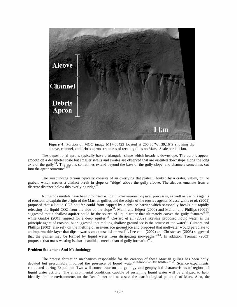
Malin and Edgett (2000) reported the occurrence of gully features in the mid and high latitudes of Mars on the walls of impact craters, valleys, pits, and graben. They are most abundant poleward of 30°S extending as far south as the south polar pits (~72°S), though a few occur in a similar latitude range in the northern hemisphere54,56. Generally, gully morphology can be divided into alcove, channel, and depositional-apron regions as shown in Figure 154. The theater-shaped alcove generally tapers downslope and may represent a fluid source region. The channels typically begin at the base of the alcove. Channels appear incised into the slope surface, having steep walls with a distinctive V-shaped cross section54,57. A single channel usually dominates from each alcove, but secondary channels are common. The path of each channel appears influenced by surface topography and sometimes by subsurface characteristics as a small number of channels are discontinuous and appear to flow underground before reemerging on the surface further downslope. Near the alcove-channel transition there is sometimes evidence of channels streamlining around obstacles and anastomosing channel patterns54,57.
- 25 -
Figure 4: Portion of MOC image M17-00423 located at 200.86°W, 39.16°S showing the alcove, channel, and debris apron structures of recent gullies on Mars. Scale bar is 1 km.
The depositional aprons typically have a triangular shape which broadens downslope. The aprons appear smooth on a decameter scale but smaller swells and swales are observed that are oriented downslope along the long axis of the gully54. The aprons sometimes extend beyond the base of the gully slope, and channels sometimes cut into the apron structure55,57.
The surrounding terrain typically consists of an overlying flat plateau, broken by a crater, valley, pit, or graben, which creates a distinct break in slope or “ridge” above the gully alcove. The alcoves emanate from a discrete distance below this overlying ridge57.
Numerous models have been proposed which invoke various physical processes, as well as various agents of erosion, to explain the origin of the Martian gullies and the origin of the erosive agents. Musselwhite et al. (2001) proposed that a liquid CO2 aquifer could form capped by a dry-ice barrier which seasonally breaks out rapidly releasing the liquid CO2 from the side of the slope58. Malin and Edgett (2000) and Mellon and Phillips (2001) suggested that a shallow aquifer could be the source of liquid water that ultimately carves the gully features55,59, while Gaidos (2001) argued for a deep aquifer.60 Costard et al. (2002) likewise proposed liquid water as the principle agent of erosion, but suggested that melting shallow ground ice is the source of the water61. Gilmore and Phillips (2002) also rely on the melting of near-surface ground ice and proposed that meltwater would percolate to an impermeable layer that dips towards an exposed slope wall62. Lee et al. (2002) and Christensen (2003) suggested that the gullies may be formed by liquid water from dissipating snowpacks63,64. In addition, Treiman (2003) proposed that mass-wasting is also a candidate mechanism of gully formation65.
Problem Statement And Methodology
The precise formation mechanism responsible for the creation of these Martian gullies has been hotly debated but presumably involved the presence of liquid water54,55,56,57,58,59,60,61,62,64,66,67,68. Science experiments conducted during Expedition Two will concentrate on the geology and geophysical characteristics of regions of liquid water activity. The environmental conditions capable of sustaining liquid water will be analyzed to help identify similar environments on the Red Planet and to assess the astrobiological potential of Mars. Also, the
- 26 -
morphology of the terrestrial fluvial systems will be documented to compare the morphology of terrestrial and Martian structures and assess the similarities and differences between these geomorphic features on both planets. Such comparative planetology studies are essential for placing constraints on the precise formation mechanism of the Martian gullies (for example, distinguishing between open channel vs. debris flows). In addition, the environmental parameters are important input variables for a previously developed numerical model of surficial water flow on both Earth and Mars. By understanding the physical conditions under which liquid water exists on Earth, we can improve our theoretical understanding of the behavior of liquid water on Mars.
Equipment
Planned field experiments for Expedition Two are not dependent upon daynight cycles and no cover over instruments in the field is necessary. Equipment can be left in the field for extended periods of time. The majority of the time during Expedition Two will be spent in the field and most necessary laboratory work will be conducted back at NASA Ames.
Work will concentrate on characterizing the physical environment in regions of past and/or present liquid water activity, the surficial manifestations of such water activity, and the composition of the water solution itself. All sites will also be digitally imaged.
Data to be collected is listed below:
• Air Temperature : Air temperature is the dominant factor controlling the hydrological cycle at sites of perennial springs on Earth and hence is a critical parameter regarding the surface activity of water.
• Ground temperature: Thermal conduction from the flowing liquid water within a spring and/or gully system to the ground must be incorporated into the energy balance describing surficial flow.
• Wind speed and direction: Accurate characterization of the wind regime is critical for determining rates of evaporation from the surface of the flowing liquid.
• Insolation: Insolation varies over both diurnal and seasonal cycles and accurate measurements of incoming radiation are needed to complete the energy balance describing surficial flow.
• Thermal conductivity of overburden: Thermal conductivity values vary over orders of magnitude for different geologic materials and the thermal conductivity is the largest unknown factor in determining the depth to the 273 K isotherm (an important parameter when considering a shallow aquifer as the liquid water source for the Martian gullies). This parameter will therefore be measured to characterize the geophysical setting of the terrestrial gullies and springs to help us determine their mechanism of formation.
• Geomorphology of features: The geomorphology of fluvially carved features will be assessed to understand how different surface manifestations result from various processes of formation. Comparisons can then be made with Martian landforms as observed with the Mars Orbiter Camera to help determine formational processes.
• Particle size distribution along channel: Particle size distributions are useful for placing constraints on flow rates. Therefore the particle sizes of the channel bed materials will be measured to determine the past history of water flow.
• Length of alcoves, channels, debris aprons: The length of various features within a gully system (alcoves, channels, and debris aprons) is indicative of the amount of fluvial activity that has occurred in the system. The size of the alcoves indicates the amount of headward erosion into the host rock that has occurred as a result of flowing water. The channel length indicates the distance of channelized flow and places constraints on the maximum distance that liquid water can flow over the surface. The size of the debris aprons places constraints on the amount of sediment which has been transported and deposited downstream which is also correlated with water content.
• Elevation of alcoves, channels, debris aprons : Elevation data is combined with the length measurements of the alcoves, channels, and debris aprons to determine the slopes of these features. Alcove slopes are primarily important for comparisons with the angle of repose to determine if sediment is stable in these regions or could
- 27 -
be subject to failure and slumping to stimulate debris flows. Channel slope is critical in calculating the flow velocity of a liquid and is a critical parameter in numerical simulations of open channel flow.
• Varying soil chemistry of soils within channels (in contact with water flows) vs. surrounding terrain: Most naturally-occurring water contains some amount of impurities and often water sequestered within the subsurface has a measurable quantity of total dissolved solids. Therefore water flowing over the surface may chemically interact with the underlying soil to leave a traceable signature indicative of the water composition. Soil deposits within the channel will be compared with undisturbed soils in the surrounding terrain to test chemical indications of past water flow.
• Density of soils along channel: Soil density is an important parameter for determining the subsurface heat flow. Calculations of temperatures at depth are dependent upon the density of the overburden and this parameter must be constrained through direct measurement.
• Water chemistry: Chemical analysis of the water flowing from the gullies and springs yields great insights into the subsurface composition of material that the water has passed through before reaching the surface. The chemical composition of the water is also important for understanding the surficial behavior of the water (i.e. freezing point depressions, vapor pressure suppression, etc).
• Geologic setting (identification of nearby water sources?): The accessibility of Australia will allow for reconnaissance of the surrounding terrain to identify potential source sites for the water feeding the springs and gullies.
• Gas sampling (if applicable) for gases released from spring water (similar to Arctic): Springs in the polar environment of the Canadian Arctic release gaseous bubbles of nitrogen as the spring water reaches the surface. If a similar phenomenon is observed in Australia, the gases will be collected and subsequently analyzed to determine their chemical composition which leads insights into the chemical interaction of the water with subsurface materia ls.
• Flow rate (if applicable ) for channels : If channels are active during Expedition Two then flow meters can be installed to accurately measure the flow rates within a channel. Flow rates are critical for constraining the amount of water flowing through the system.
Relevance
This proposed research is directly relevant to the overarching scientific research directions of the US Mars Exploration Program (MEP) as well as the general scientific program as expressed in R. Persaud, "A Systematic Approach to Studies at the Mars Analog Research Stations", Martian Expedition Planning (ed. C. Cockell), AAS, 2004. [make footnote?]This work directly addresses several critical areas of research outlined by the Mars Exploration Payload Analysis Group (MEPAG) as well as the Space Studies Board report of the Committee for Planetary Exploration (COMPLEX).
Below several MEPAG objectives are stated as well as the proposed research contributions which would help increase the state of knowledge in each area.
1. Establish the current distribution of water in all its forms on Mars. 2. Identify and characterize deposits affected by hydrological processes.
The Space Studies Board report of the Committee for Planetary Exploration (COMPLEX) outlined several critical areas of Mars research. Work to be completed through this proposal is far-reaching and falls within several categories outlined by COMPLEX as described below.
1. Surface Processes and Geomorphology. 2. Ground Ice, Groundwater, and Hydrology.
Additionally, work proposed here complies with the Strategic Goals, Science Objectives, and Research Focus Areas (RFAs) of the NASA Office of Space Science. Our work is most relevant to Strategic Goal II: Explore
- 28 -
the Solar System and the Universe beyond, understand the origin and evolution of life, and search for evidence of life elsewhere. We address Science Objectives 4 and 6 as described below.
Science Objective 4: Understand the current state and evolution of the atmosphere, surface, and interior of Mars.
RFA: Investigate the history and behavior of water and other volatiles on Mars. We will conduct a study of the gully features (associated with liquid water and/or water ice) to improve our understanding of water activity on Mars in the geologically recent past. Our work will use quantitative analysis based on spacecraft observations and terrestrial analog studies to place constraints on our theoretical model of liquid water on Mars.
Science Objective 6: Develop an understanding of Mars in support of possible future human exploration.
RFA: Inventory and characterize Martian resources of potential benefit to human exploration of Mars. Our work will address the distribution, origin, and potential accessibility of liquid water and solid ice reservoirs on Mars. Information gleaned from our study will be critical for evaluating the potential in situ use of water reservoirs in support of human missions to Mars.
Work conducted during Expedition Two addresses the following Mars-analog science questions as listed by Persaud (2004) [footnote?].
1. What is the history of the fluvial and aeolian landscape? 2. What is the history of water in the area?
These Mars Expedition questions are categorized in the “Opportunity” mission class and falls under Mission Theme G: Missions of Opportunity on Level 1 geological goals as described in Persaud (2004) [footnote?].
Field Notes:
August 3, 2004
Tuesday consisted of a day-long tour of the surrounding Arkaroola region led by Dr. Vic Gostin. The ExTwo crew was accompanied by the UTS students for an overview of the geologic terrains surrounding Arkaroola. Field stops along the traverse consisted of viewings of sedimentary outcrops, ripple marks within the layered deposits, breccia rocks, tillite deposits, caliche coatings, Stubbs water hole, open plain landscapes, canyons, dry streambed crossings, etc. The geologic diversity of the Arkaroola region was dramatically highlighted by this first field excursion as an ideal start to Expedition Two.
During this field traverse, ExTwo members were also scouting for prime locations for the establishment of the Mars-Oz habitat. Digital imagery and field notes of the various settings were obtained for further consideration. The geologic diversity of the region resulted in several candidate sites that were under consideration.
Of particular interest to my research was the visit to the Paralana Hot Springs. These springs are in the Northern Flinders Ranges and are located along the Paralana fault. The granitic rocks of the region have high concentrations of radioactive elements which contribute to the high heat flows of the region. This unique combination of a subsurface water source, fault lines allowing for a surface connection with this water, and the high heat flow values produces these radioactive hydrothermal hot springs of Paralana.
Air and water temperatures at the Paralana hot springs will be monitored by remote dataloggers. Equipment was installed at two sites (Site 1: several hundred meters from spring outlet, Site 2: at spring outlet).
Site 1: 30º 10’ 35” S, 139º 26’ 34.1” E Water temperature measured onsite: 25ºC Sensors installed include 1 Hobo Tidbit logger, 1 Hobo WaterTemp Pro logger
- 29 -
Site 2: 30º 10’ 30.1” S, 139º 26’ 29.2” E Water temperature measured onsite: 50ºC Sensors installed include 1 Hobo Tidbit logger, 1 Hobo WaterTemp Pro logger, 1 Hobo Pro logger (air temperature and air RH).
August 4, 2004
The Paralana Hot springs were visited on Wednesday afternoon to bring two members of the press to the site for interviews and photographs. While at the site the dataloggers were checked to ensure they were still emplaced within the springs water. All systems were nominal and the site was once again digitally imaged for documentation purposes.
August 5, 2004
On Thursday afternoon instrumentation was installed on a rock relatively close to the main ExII base at the Shearer’s Quarters to monitor temperature variations at different locations along the rock surface. Based on the path of the sun over the course of a day, different regions of a given rock will experience different temperature variations which may induce thermal stresses with the rock. Over long timescales such stresses may induce thermal fractures within the rock itself. This experiment is therefore a continuation of on ongoing study to monitor the thermal variations of rocks in desert environments at different latitudes on Earth.
Six thermocouples connected to a Campbell datalogger were attached to the rock surface. The rock is located at 30º 20’ 2.9” S, 139º 22’ 7.2” E. Rock dimensions are 50 cm (length) x 35 cm (width) x 20 cm (max height). Thermocouples were installed at several locations: 1. East side of rock at soil line, 2. West side of rock at soil line, 3. Top of rock, 4. NW side of rock, 5. NE side of rock, 6. South side of rock at soil line. Temperatures will be recorded at one minute intervals.
August 6, 2004
The thermocouple rock located near the Shearer’s Quarters was revisited on Friday afternoon by Jon, Steve Dawson, Dave, and Jen. The purpose of this trip was to check the Campbell datalogger to ensure that the system was still collecting data and that the thermocouples were still firmly attached to the rock. Two thermocouples were reinstalled and the datalogger appears to be operating nominally.
August 9, 2004
The crew packed the rovers and trailer with necessary gear and departed base camp (Shearer’s Quarters, Arkaroola) in the late morning. Crew spent the afternoon searching for previously mapped mound springs throughout the Moolawatana region. The site at Twelve Springs was examined but deemed unsuitable for future studies due to the lack of appreciable surface water (no pools, channels) and the nearby proximity of grazing cattle which would disrupt remote datalogging equipment. Camp site was established in the evening and the crew spent the night within the Moolawatana region.
August 10, 2004
Crew awoke in the morning to pack up the camp and load the trailer for transport to the next field site. The day was spent driving to the next field site near the Gurra Gurra waterhole. An additional springs site was visited but was again deemed unacceptable due to the lack of surface water and clear geomorphic features. Evening camp was established in the Gurra Gurra vicinity and dunes were examined in the nearby region.
August 11, 2004
Crew loaded trailer and departed for next field site at Hamilton Creek. Camp was established and then the crew went to the field site atop an approximately 10m height sand dune. Auguring equipment was carried to the dune crest and the crew began to auger a core hole into the sand dune. Samp les were collected every ~10-20 cm for
- 30 -
on-site sediment analysis. Additional samples were collected for subsequent laboratory dating. The crew drilled several meters into the sand dune before retiring to the campsite at dusk.
August 12, 2004
Crew arose and returned to the sand dune site to continue auguring into the dune. Crew spent the day at the site and augured down to 8.4 m depth. Sediment samples were collected every 10-20 cm and additional samples were again collected for subsequent laboratory dating. Upon completion of the sand dune auguring the crew packed up the equipment and returned to base camp (Shearer’s Quarters, Arkaroola).
August 15, 2004
1. Investigation of thermally cracked rocks near Mars-Oz site.
GPS coordinates: 30º18’20.1” S, 139º26’55.3” E, 167 m elevation
Numerous examples of thermally cracked rocks were discovered just across the dirt road from the Mars -Oz Hab site. Rocks located on the surface of the planet, especially in desert regions such as those surrounding Arkaroola, are subject to extreme temperature variations both seasonally and diurnally. These stresses can become great enough to induce fracturing which results in a mechanical breakdown in the rock. A corresponding change in the rock size distributions may then tend to favor smaller rock fragments.
Similar processes may be working on Mars and may be important for understanding the rock size distributions on the Red Planet. Several examples of such thermally-cracked rocks near Arkaroola are shown below. These rocks were transported and deposited in their current location so the thermal cracking must have occurred in situ. These rocks help support the hypothesis regarding this method of rock breakdown and quantitative data is being collected on a typical rock near the Shearer’s Quarters by monitoring rock temperatures using thermocouples and remote dataloggers to record the thermal variations on different portions of the rock. Such information can then be used to theoretically model the induced stresses and determine the conditions necessary for the thermal stress fractures.
2. Instrumentation installed at Nepouie Springs.
GPS coordinates: 30º28’13.4” S, 139º21’31.0” E, 141 m elevation
Nepouie springs consists of two pools of water and a relatively extensive channel system which spans over 500 meters. The upper pool is cooler (18ºC) and shows no obvious signs of extended flow. At the end of this pool is a ~2 foot drop into a second pool of warmer water (27ºC). Some subsurface mixing of this warm and cool water most likely occurs as water in the lower pool is cooler closer to the 2 foot drop and the upper cool pool. The water continues downstream in several smaller (several foot wide) channels which emanate from the lower pool. The pools and streams are teeming with life and were studied and sampled by the biology team.
Dataloggers were installed to monitor the water and air temperatures as well as the ambient relative humidity.
• Four channel external Hobo datalogger: Channels 1 & 2 in upper cold pool. Channels 2 & 3 in lower warm pool.
• Hobo Pro Air & RH datalogger left installed at Nepouie site.
• Additional four channel external Hobo datalogger installed into warmest portion of bottom pool on August 17, 2004.
- 31 -
August 16, 2004
1. Temperature monitoring of thermal rock variations.
GPS coordinates: 30º20’2.9” S, 139º22’7.2” E, 141 m elevation
Instrumentation was installed on 5 August 2004 on a rock relatively close to the main ExTwo base at the Shearer’s Quarters to monitor temperature variations at different locations along the rock surface. Based on the path of the sun over the course of a day, different regions of a given rock will experience different temperature variations which may induce thermal stresses with the rock. Over long timescales such stresses may induce thermal fractures within the rock itself. This experiment is therefore a continuation of an ongoing study to monitor the thermal variations of rocks in desert environments at different latitudes on Earth.
Six thermocouples connected to a Campbell datalogger were attached to the rock surface. The rock is located at 30º 20’ 2.9” S, 139º 22’ 7.2” E. Rock dimensions are 50 cm (length) x 35 cm (width) x 20 cm (max height). Thermocouples were installed at several locations: 1. East side of rock at soil line, 2. West side of rock at soil line, 3. Top of rock, 4. NW side of rock, 5. NE side of rock, 6. South side of rock at soil line. Temperatures will be recorded at one minute intervals. The Campbell datalogger was reprogrammed on 16 August 2004. Data was output to both the final storage locations within the datalogger as well as to the peripheral storage module. Such a system gives redundancy in the data recording to ensure no data is lost during the course of the experiment.
August 17, 2004
1. Deployment of Hobo Pro at Hab Site and detailed documentation re. directions to Hab site.
A Hobo Pro datalogger was installed at the Mars-Oz Hab site to record air temperature and air humidity at two minute intervals for the next year. Detailed directions from the Shearer’s Quarters to the Hobo Pro were recorded such that a subsequent team can recover the datalogger next year and retrieve the data.
August 18-19, 2004
Jen Heldmann and the Clarke family (Jon, Anna, Rosalind, and Jennifer) left Arkaroola for an overnight trip to visit mound springs located along the Oodnadatta Track. The crew drove from Arkaroola through Leigh Creek and then north to Maree. From here the Track heads west towards Lake Eyre (South) and then turns northwest to the crew’s furthest point away from Arkaroola at William Creek. The crew overnighted at William Creek and then returned to Arkaroola the following day. The mound springs are formed from an accumulation of dissolved salt deposits and most have high levels of dissolved solids. The springs form an arc from Lake Callabonna through Marree towards Oodnadatta.
August 20, 2004
The end of Week 3 marked the last day of the Expedition for me and so I spent this day returning to the field sites to download data that had been collected by the dataloggers thus far. I revisited the thermocouple rock near the Shearer’s Quarters, Paralana hot springs, and Napouie springs. A sample of this data is presented below. Loggers were left at each of these sites to provide continued monitoring for the next year.
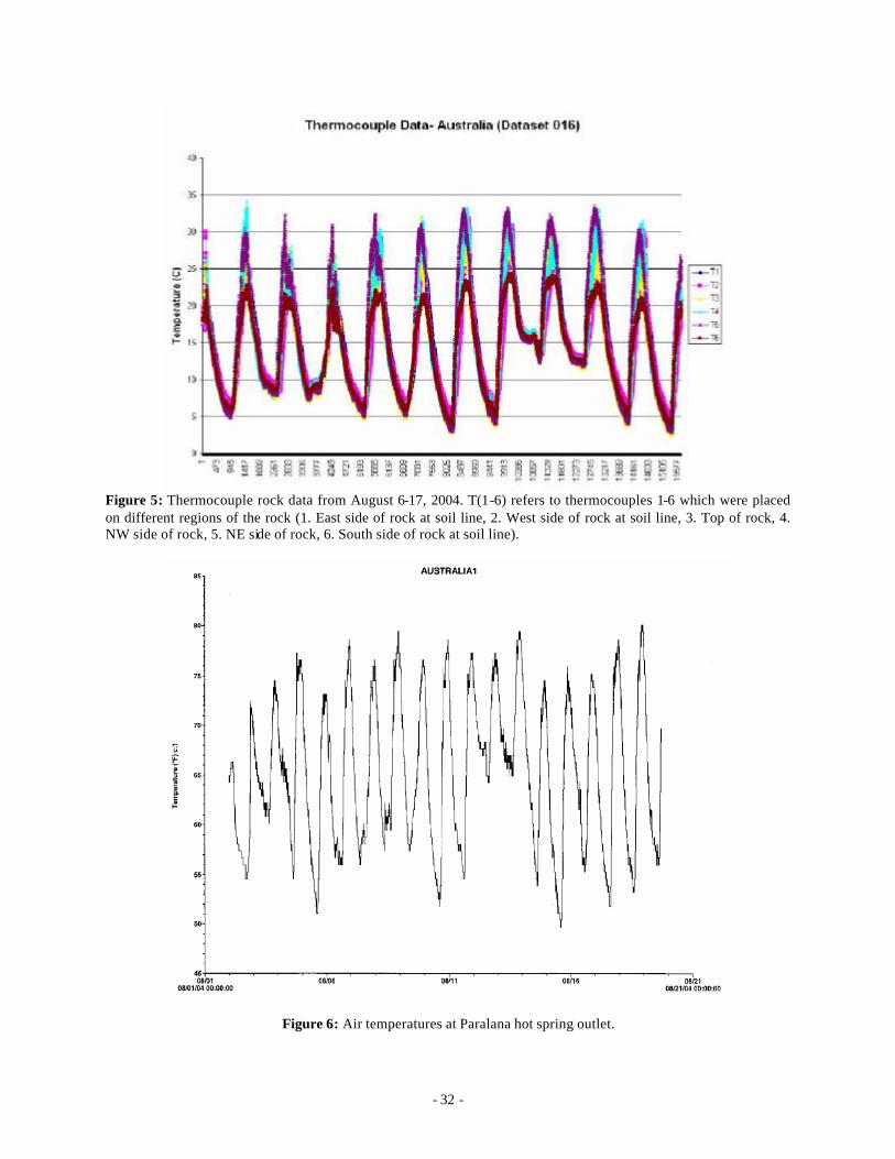
- 32 -
Figure 5: Thermocouple rock data from August 6-17, 2004. T(1-6) refers to thermocouples 1-6 which were placed on different regions of the rock (1. East side of rock at soil line, 2. West side of rock at soil line, 3. Top of rock, 4. NW side of rock, 5. NE side of rock, 6. South side of rock at soil line).
Figure 6: Air temperatures at Paralana hot spring outlet.
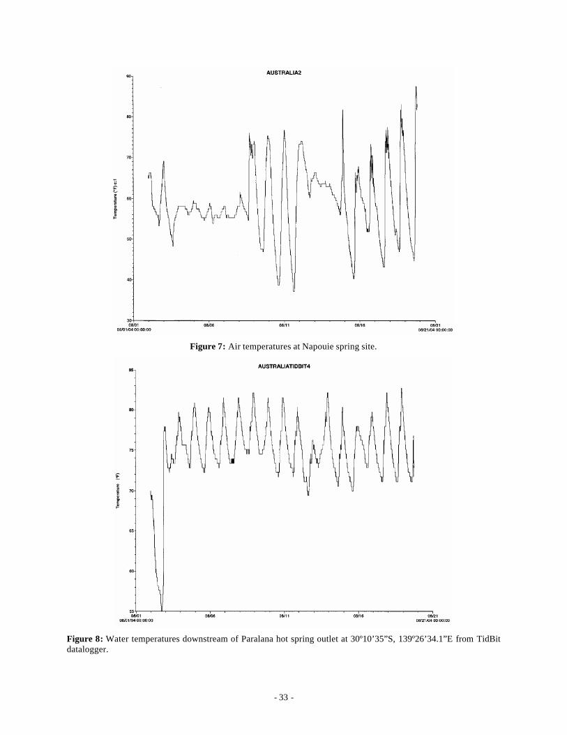
- 33 -
Figure 7: Air temperatures at Napouie spring site.
Figure 8: Water temperatures downstream of Paralana hot spring outlet at 30º10’35”S, 139º26’34.1”E from TidBit datalogger.
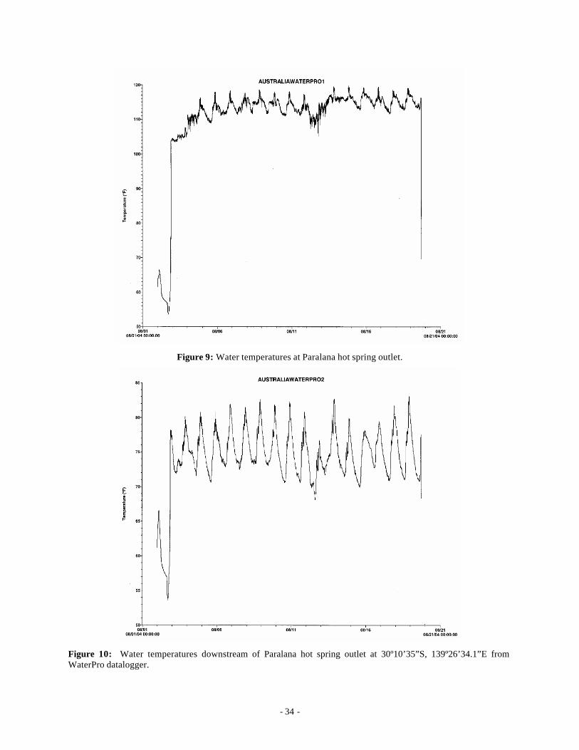
- 34 -
Figure 9: Water temperatures at Paralana hot spring outlet.
Figure 10: Water temperatures downstream of Paralana hot spring outlet at 30º10’35”S, 139º26’34.1”E from WaterPro datalogger.
- 35 -
PROJECT FOUR: Remote methods for detection of hydrothermal activity in Mars Analog regions, an example from the Mt. Painter District, northern Flinders Ranges, South Australia
Adrian Brown, Matilda Thomas, and Michael West
Abstract:
It is proposed to bring a variety of remote mapping techniques to bear on resolving the problem of mapping hydrothermal alteration in the Mt. Painter district near Arkaroola. The field component of this research will be conducted for two weeks of the Expedition Two mission to Arkaroola. This will involve a directed sampling mission to collect samples from areas identified as interesting after analysis of the remote datasets.
Problem State ment:
The mapping of large scale hydrothermal systems presents difficulties of scale and scope to the individual researcher on the ground. In a Martian environment, the scientist on the ground will be guided by an extensive array of remote datasets currently being collected by such instruments as the Thermal Emission Spectrometer (MGS-TES)69 and Gamma Ray Spectrometer (MO-GRS)70. Future missions will involve hyperspectral VNIR spectrometry (CRISM)71. Experience in applying these types of remote datasets to Earth bound problems will assist the future Martian explorers by formulating techniques and best practices to capitalize on the strengths of each particular dataset type.
Methodology:
The following remote datasets have been collated by the research team in preparation for this task:
- Landsat multispectral VNIR imagery over several years
- ASTER multispectral VNIR-SWIR imagery from 2003
- HyMap imagery from 1998
- Gamma Ray data provided by PIRSA
The datasets will be geospatially correlated using the ENVI program from RSI, and overlain to produce alteration maps utilizing the diagnostic hydroxyl band absorptions which are detectable in LandSat, ASTER and Hymap.72 These will be correlated with K, U and Th abundances from the gamma ray data.73
The PIMA SWIR spectrometer will be used to analyse geological units recognized from the airborne datasets.74 Preliminary investigations with the PIMA have already been carried out75 and these results will be expanded upon during this study. An extensive sampling regime will be enacted to characterize the units geologically, primarily using XRF techniques.
In the field, samples will be located and logged using the ArcPad software running on a Windows PC connected to GPS equipment. This will enable a sample database to be built up over time in the area under the custodianship of the MSA.
Remote mapping of alteration mineralogy will be compared with established geological mapping76,77,78,79,80 to place the hydrothermal events in a geological context and timeframe. Attempts will be made to identify relationships with stromatolite horizons81 in the area, in order to undertand whether they are related to palaeo-hydrothermal sites.
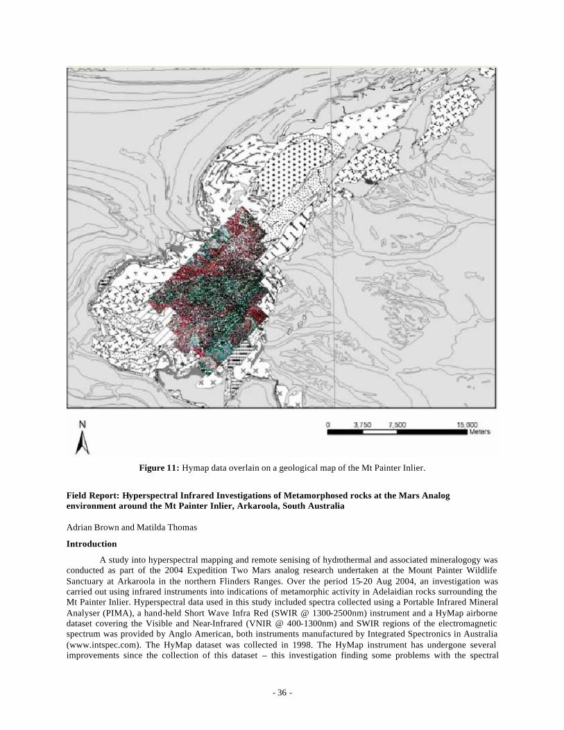
- 36 -
Figure 11: Hymap data overlain on a geological map of the Mt Painter Inlier.
Field Report: Hyperspectral Infrared Investigations of Metamorphosed rocks at the Mars Analog environment around the Mt Painter Inlier, Arkaroola, South Australia
Adrian Brown and Matilda Thomas
Introduction
A study into hyperspectral mapping and remote senising of hydrothermal and associated mineralogogy was conducted as part of the 2004 Expedition Two Mars analog research undertaken at the Mount Painter Wildlife Sanctuary at Arkaroola in the northern Flinders Ranges. Over the period 15-20 Aug 2004, an investigation was carried out using infrared instruments into indications of metamorphic activity in Adelaidian rocks surrounding the Mt Painter Inlier. Hyperspectral data used in this study included spectra collected using a Portable Infrared Mineral Analyser (PIMA), a hand-held Short Wave Infra Red (SWIR @ 1300-2500nm) instrument and a HyMap airborne dataset covering the Visible and Near-Infrared (VNIR @ 400-1300nm) and SWIR regions of the electromagnetic spectrum was provided by Anglo American, both instruments manufactured by Integrated Spectronics in Australia (www.intspec.com). The HyMap dataset was collected in 1998. The HyMap instrument has undergone several improvements since the collection of this dataset – this investigation finding some problems with the spectral
- 37 -
accuracy of the dataset - but nonetheless, extremely useful variations could still be detected in both outcrop and regolith mineralogies.
Mission Background
The Arkaroola region has been proposed as the site of a Mars Analog Habitation module sponsored by the Mars Society Australia (MSA). Expedition Two was planned as a collaborative mission between MSA and the Mars Society Canada (MSC). This project was carried out with the intention of appraising the ability of a VNIR-SWIR remote sensing dataset to complement geological studies carried out by human explorers with hand held SWIR spectrometers on the surface of Mars. In 2006, the collection of a high resolution VNIR-SWIR dataset of the Martian surface will begin when the CRISM instrument enters Martian orbit onboard the Mars Reconaissance Orbiter.
Geology
The geology of the northern Flinders Ranges include highly altered Archean basement surrounded by sediments of the Adelaidean Fold Belt and intrusive volcanics of the Wooltana sub group and intrusive granites. Hydrothermal alteration associated with the instrusion of the Mt Neil granite has altered rocks studied in this investigation, and contributed to the pervasive mica alteration and schistose foliations present within all these units.
The area investigated in this study is displayed in the figure below. This constituted the area covered by the southernmost swathe (swathe 1) of the HyMap dataset. Geological units included the units of the Lower Callanna Beds of the early Wilouran Adelaidean. These included the sandstones of the Humanity Seat Formation, basaltic Wooltana Volcanics, Paralana Quartzite, hornfels Whywyana Formation. In addition, rocks of the Woodnamoka Phyllite (belonging to the Upper Callanna beds) and the intrusive Mt Neill granite porphyry (of the ‘Older Granite suite’) were also investigated. The area is cut by a the listric normal Paralana Fault System, which runs north-south through the region as indicated in the figure.
Field Methodology
Testing and sampling was carried out at various locations chosen via analysis of the HyMap airborne instrument. The airborne hyperspectral sensor can samples only the top 1-2 millimetres of the surface material, and thus is sensitive to coverings such as desert varnish and transported cover such as scree slopes and sediment deposits.
Samples collected from the field were ana lysed at the base camp, both weathered and freshly broken surfaces were compared to enable a comparison between HyMap detected mineralogy and PIMA analysis of the fresh mineralogy. Preliminary results indicate that Fe oxide rich dust had minimal affect on the ability of the HyMap to distinguish between significant mineralogical variation. Fe indurated samples displayed a strong Fe2+ curve in the SWIR region when analysed with the PIMA. Interfearance from other widespread surface coatings such as lichen appeared to be minor, although pervaussive iron or calcium induration produced a strong spectral response which could mask other diagnostic mineral absorbtion features. Due to this markedly indurated sediments were avoided except for comparision with nonindurated samples.
Results
A comparison of the HyMap results from around Mt Painter and Mt Gee (in swathe 3 of the HyMap dataset) revealed that the quartz breccias of the famous Mt Gee hydrothermal system were largely impenetrable using the VNIR-SWIR HyMap sensor. This contrasted with the contact metamorphosed mica-rich sedimentary rocks and basaltic volcanics of the Lower Callanna Beds, covered by swathe 1 and swathe 6. Areas covered by swathe 6 were investigated on the second day of the study but due to access difficulties (swathe 6 covered extremely rugged terrain with variations of height from 300-500 AMSL and was two hours from the base camp). For this reason, it was decided to concentrate on ground analysis of swathe 1 in the time available.
Hand samples were collected from all accessible rock types in swathe 1 and the mineralogy compared between HyMap and PIMA measurements. Due to the lack of spectral contrast (discussed earlier), the HyMap mineralogy is relatively imprecise. Results of the survey are presented in Table 1.
- 38 -
Detected Mineralogical Phases Geological Unit HyMap PIMA Hand Sample Woodnamooka Phyllite Al and Fe-OH Humanity Seat Formation Al-OH Wooltana Volcanics Mg-OH or carbonate Mg-Chlorite Chlorite Whywyana Formation Mg-OH or carbonate Actinolite Paralana Quartzite Al-OH Muscovite Mount Neill Granite Porphyry
Al-OH and Mg-OH ‘Cats Eye’ Quartz, Feldspar
Table 1: Mineralogy detected by HyMap, PIMA, and hand samples
Comparison with ASTER data
A swathe of data covering the Arkaroola region taken by the satellite-borne multispectral imager, ASTER, was compared to the HyMap dataset of swathe 1. Processing carried out on the ASTER dataset included continuum removal of the SWIR bands. The metamorphosed Paralana Quartite is detectable using a false colour combination of continuum removed bands due to the Al-OH absorptions at 2.2 microns in mica within this unit. This is seen in the figure below. No other geological units are easily detectable using ASTER.
Conclusion
This study has investigated variations in the rocks of the Wilouran Lower Callanna Beds and the intrusive Mt Neill granite porphyry. The survey has shown the ability of the two infrared instruments, the PIMA and HyMap, to determine differing mineralogy in highly metamorphosed sedimentary and volcanic rocks. The ability of the HyMap to provide region wide targets and possible survey points for higher resolution spectral analysis using the PIMA shows what can be achieved in a short period using such synergistic instruments. Complementing remote sensing with surface hand sample analysis by astronauts on Mars would provide a worthwhile strategy for efficient geological survey of resources by human explorers and may increase the likelihood of finding niches for fossilised or extant signs of life on Mars.
- 39 -
PROJECT FIVE: The evolution and dynamics of desert dunes in the Lake Eyre Basin, South Australia
Kathryn Fitzsimmons
Research Summary
Arid landscapes provide a sensitive record of environmental change. The geomorphic evolution of the extensive desert dunefields of central Australia can be used as an analog for climate change during the late Quaternary. The transverse and longitudinal dunes downwind of major playas, and longitudinal dunes developed on floodplains of active dryland river systems, are particularly responsive to small changes in both climate and hydrology. Understanding the interaction between these two major genetic dune types therefore becomes important for the interpretation of timing and conditions required for dune building.
At present, the evolution and dynamics of the Australian desert dunefields, which occupy well over one third of the surface area of the continent, are an unresolved problem. This project aims to address at least part of this issue by investigating a regional history of aeolian deposition and processes over time. This study will focus on the geomorphology of the longitudinal dunes within the Strzelecki and Tirari Deserts, in particular those areas downwind of Lakes Frome, Callabonna, Gregory and Eyre. It is a region which incorporates extensive longitudinal dunefields of variable morphology and orientation, lying downwind of major playas and several generations of associated lunettes. The geomorphic relationship between the transverse and longitudinal dunes is both clearly demonstrated and accessible in this region.
The regional landscape evolution will be interpreted based on ASTER satellite imagery, and field observations of dune morphology, stratigraphy and sedimentology. Morphologic patterns will be clarified through the objective classification of different dune types within geomorphic maps produced from the satellite imagery. Sedimentological studies will investigate the processes of dune formation. This geomorphic history will be placed within a chronologic framework using optical dating techniques.
Field area and study sites
This project aims to understand the regional geomorphology based on strategic sites within the region. The region encompasses numerous large playas, downwind of which lie transverse dunes, and downwind of these, longitudinal dunes of variable orientation. Longitudinal dune morphology exhibits great variety in spacing and levels of organisation across the dunefield, and is thought to be related to more local variables such as substrate type and sediment availability. Individual study sites will reflect this diversity in morphology, and the chronology of these sites will investigate possible relationships between local morphologic changes and the regional palaeoenvironmental history.
Field work will include the identification of individual study areas through reconnaissance (and based upon the geomorphic maps), topographic surveying using a total station, field observations of stratigraphy and sediments, sedimentological and OSL (Optically Stimulated Luminescence) sampling, and the possible use of ground penetrating radar to investigate stratigraphy and structure below the surface. Ideally, individual study sites will have good exposure of internal dune stratigraphy, such as in road cuttings and eroded artesian bore sites, although stratigraphy can also be determined through vertical augering. The sampling of undisturbed lower parts of stratigraphic horizons is the aim for OSL dating.
Proposed study areas include northeast Lakes Frome and Eyre, Lakes Callabonna and Gregory, and Innamincka. The area northeast of Lake Frome comprises four well defined lunette systems and associated dunes, and as such is advantageous for the study of the relationship between lunettes and longitudinal dunes. The area northeast of Lake Eyre comprises the active Warburton Creek and numerous elongate playas and clay flats, which may represent old channel traces, upon which longitudinal dunes have formed. The orientation of the longitudinal dunes of the Strzelecki Desert is at its most variable around Lake Callabonna. Lake Gregory adjoins extensive swampy floodplains and gibber plains associated with the Cooper Creek to its west, and the geomorphic relationships between longitudinal dunes and these landforms is well illustrated in this area. The Innamincka area, at the downwind end of the Strzelecki Desert, exhibits the greatest diversity in dune forms and substrates, including active floodplains and gibber desert.
- 40 -
PROJECT SIX: Neotectonics of the alluvial fans of the Lake Frome Plains
Vic Waclawik
The researcher is Vic Waclawik (Dept. Earth and Environmental science, University of Adelaide). This work is towards Vic Waclawik’s PhD. During field work the researcher will examine the signature of neotectonic events on the geomorphology, sedimentology, and induration of the fans draining east from the northern Flinders Ranges.
August 10, 2004
Vic Waclawik and Vic Gostin traveled to Paralana Hot Springs to conduct an investigation into sedimentary and geomorphologic responses to tectonic activity.
A brief investigation of Paralana Hot Springs was undertaken and revealed the presence of granitic rocks in the region surrounding the springs. This area is bounded on the eastern side by a fault along the foot of the ranges. Deposited along the eastern flank of the ranges are colluvial surfaces that have been incised by modern creeks. This indicates that there has been tectonic movement along the range front that has resulted in the previous erosional surface being eroded by these creeks as they respond to the uplift of the Paralana High Plains.
Capping the eroded surface at the foot of the range front near the Old Paralana homestead is a deposit of silcrete. This is a deposit of river gravels that have been cemented by silica. All of the grains and pebbles preserved in the silcrete have been converted to quartz yet retain the original texture of the river sediment. Current theories on the origin of silcretes suggest that the silica is mobilized in acidic environments possibly as chelates. The nearby granites weather and leach to kaolinitic clays, releasing silica, and producing acidic soils. This silcrete can therefore be interpreted as a deposit formed at the footslope of an alluvial fan where analogous environments are often present today.
Overlooking Yudnamutna Gorge and elevated above the Paralana High Plains silcrete is a further silcrete. This silcrete forms a discontinuous surface equivalent to the Paralana High Plains silcrete. It displays significant variation in the preserved texture. Grain sizes tend to be larger and more angular with clasts up to 5cm. Graded bedding is visible as are other sedimentary features such as mud-drapes and coarse lenses deposited by river channels. The texture of these sediments is interpreted as deposits of coarse sediment derived from granite, called gruss, which have been silica cemented. These are likely to have been derived from granites forming part of the bedrock geology of the ranges.
The interpreted sedimentary environment for the deposition of the silcrete is at the top or middle of an alluvial fan. The topographic position in the landscape of this silcrete is atop a cliff overhanging Yudnamutna Gorge, yet it was originally deposited at the base of the ranges. It therefore has been uplifted from its original position. This is consistent with the model of landscape evolution developed for the region that notes inherited meanders in Yudnamutna Creek and valley-in-valley structures that indicate tectonic activity along the rangefront.
August 11, 2004
Vic Waclawik and Vic Gostin drove to Wooltana station to investigate the sedimentary expression of tectonic activity along the edge of the ranges and to examine the distal end of the eastern alluvial fans.
First stop was Nepouie Creek where a cemented limestone was observed. This limestone was essentially a palaeo-creek bed that has been cemented by calcium rich waters during a period with higher intensity rainfall events. Thus it is an indicator of climatic variation within the Quaternary.
Further stops were made to investigate raised ridges located by the roadside. These ridges were found to be underlain by basalt flows and were composed of large quartzose boulders and other quartz rich sediments, including rare clasts of silcrete. These raised gravels are interpreted as alluvial fan debris flows that have been uplifted by Quaternary faulting and eroded by streams.

- 41 -
The distal portion of the eastern alluvial fans were investigated for evidence of tectonic activity. Several surfaces were identified including the base of the modern alluvial channel, alluvial terraces of the modern streams and raised palaeo-surfaces of the alluvial fan. Modern alluvial channels were observed cutting away the palaeo-surfaces through headward erosion.
August 12, 2004
The purpose of this investigation was to explore and map the geology east of the Arkaroola Springs track. At the eastern end of Claude Pass the modern stream of Groan Creek turns sharply south. The tops of the mesas at this point consist of a few meters of coarse polymict gravels overlying weathered basalts of the Wooltana Volcanics. Clearly, these represent the highest and oldest preserved pediment or alluvial fan surface, emerging out of the ancestral Groan Creek. The clasts consist of all the lithologies currently present in the valley of Claude Pass, and do not contain any silcretes.
Eastward, between 1 and 2km, along the track beside Lady Buxt on Creek, the presently eroding surfaces and gullies south of the main creek, were extensively covered by white quartz pebble gravels. These gave the very pale reflections on satellite images that contrasted with the dark grey colors of the basalts. Rare exposures of the underlying sediment revealed poorly consolidated, well bedded coarse to medium sands and well rounded and locally well sorted quartz pebble conglomerates. The sedimentary textures suggest an origin as beach and estuarine sands and gravels. It is probable that these represent the Cretaceous Parabarana Sandstone of the COPLEY 1:250000 Geological Map Sheet.
Isolated parts of these Cretaceous sands and conglomerates were heavily ferruginised and silicified so that they stood out as bold black outcrops. These occurred mainly along the northern edges of the outcrops on the south side of Lady Buxton Creek. In one area these occur as bedrock under the modern creek and outcrop some distance to the north.
Further east, basalts outcrop again, and both these and the Cretaceous sediments appear to fill a broad valley (?fossil estuary). All these are truncated and capped by the high-level polymict gravels that can be traced back to their sources in Groan Creek and other nearby valleys.
Immediately east of the probable Mars-Hab site the valley contains heavily weathered basalt that can be traced up to the high points where they are capped by the polymict coarse gravels with some very rounded quartz pebbles belonging to a very high pediment, probably related to the old major fans emerging out of the ancient Arkaroola Creek.
- 42 -
PROJECT SEVEN: Arkaroola Mars Analog Database
J. D. A. Clarke and D. Willson
Summary
A key feature in the selection of the Arkaroola region as Australia’s prime Mars analog region was the collection of the Jarntimara database. Described in detail elsewhere 82,83,84 (Clarke et al. 2002, Clarke and Mann 2002, Mann et al. 2004), this database allowed objective selection of the most valuable region and provides a database for future work. The database is available online at http://www.marssociety.org.au/jnt-db/ . This project is to extend the database for all sites visited in the Arkaroola region as an aid to future researchers.
Objectives
1. To provide a database on geological and biological features of Mars analog significance in the Arkaroola region
2. To collect systematic and comprehensive data on the features visited during Expedition Two for inclusion into the database.
3. To upload that data into the existing Jarntimara database on the web as a guide for future researchers.
Methodology
1. Expeditioners will fill out questionnaires on the significance of each site visited during the course of that visit. The questionnaires will include details on geology (rock types, structure, stratigraphy, regolith, palaeontology, geomorphology), hydrology, and biology (macroscopic and microscopic communities, potential extremophiles). The sheets will be based on those used in JNT-1.
2. Sites will be documented photographically
3. Data will be uploaded onto the Jarntimarra database at the end of the expedition with a clear link to it on the front page of the Mars Society Australia site.
The Selection Process of The Mars-Oz Base Site
MSA’s 2001 Jarntimarra -1 expedition identified a 200 km diameter region surrounding Arkaroola as its prime Mars analog research region. The region would also contain the site for MARS-OZ. The region was selected because it combined high scientific value, history of previous Mars-related research, reasonable accessibility, range of environments for engineering tests, and generally supportive land managers. No specific site for MARS-OZ was identified, but the general opinion of the expeditioners was that a site on the fans east of the Flinders Ranges but within the Arkaroola property would be very attractive. Such a site would again combine high scientific value, history of previous Mars -related research, reasonable accessibility, diversity of surfaces and materials for engineering evaluations, and highly supportive land managers. In addition the site itself – generally flat landscape adjacent to numerous sites of scientific and engineering interest - would be similar to that which would be selected on Mars for an actual landing.
A team consisting of David Willson (MARS-OZ project manager), Guy Murphy (MSA president), Steve Jordan (videographer), and Jonathan Clarke (geologist) spent a morning evaluating an area in the south-eastern part of the Arkaroola property. This area had been identified the previous day by Dave, Jonathan and another geologist, Vic Gostin as having considerable potential for the actual site. Two sites were examined, marked as Site 1 and 2.
Site 1 was located in a narrow belt of low rolling hills dissected by small gullies between the fans of the Lake Frome Plain and the eastern margin of the Flinders ranges. The bedrock consisted of Proterozoic Wooltana basalts cut by numerous veins of quartz-haematite breccia. Some of the hills were mantled by residual caps of transported pebbles and cobbles. The soils were red brown and swelling, and were mantled with an armour of
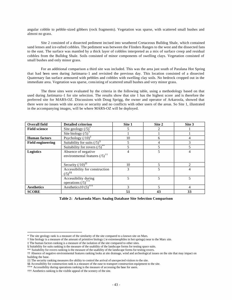
- 43 -
angular cobble to pebble-sized gibbers (rock fragments). Vegetation was sparse, with scattered small bushes and almost no grass.
Site 2 consisted of a dissected pediment incised into weathered Cretaceous Bulldog Shale, which contained sand lenses and ice-rafted cobbles. The pediment was between the Flinders Ranges to the west and the dissected fans to the east. The surface was mantled by a thick layer of cobbles interpreted as a mix of surface creep and residual cobbles from the Bulldog Shale. Soils consisted of minor components of swelling clays. Vegetation consisted of small bushes and only minor grass.
For an additional comparison a third site was included. This was the area just south of Paralana Hot Spring that had been seen during Jartimarra-1 and revisited the previous day. This location consisted of a dissected Quaternary fan surface armoured with pebbles and cobbles with swelling clay soils. No bedrock cropped out in the immediate area. Vegetation was sparse, consisting of scattered small bushes and very minor grass.
The three sites were evaluated by the criteria in the following table, using a methodology based on that used during Jartimarra -1 for site selection. The results show that site 1 has the highest score and is therefore the preferred site for MARS-OZ. Discussions with Doug Sprigg, the owner and operator of Arkaroola, showed that there were no issues with site access or security and no conflicts with other users of the areas. So Site 1, illustrated in the accompanying images, will be where MARS-OZ will be deployed.
Overall field Detailed criterion Site 1 Site 2 Site 3 Site geology (/5)* 5 2 1 Field science Site biology (/5)† 1 1 1
Human factors Psychology (/10)‡ 10 6 4 Suitability for suits (/5)§ 5 4 3 Field engineering Suitability for rovers (/5)** 5 5 5 Absence of negative environmental features (/5)††
4 5 4
Security (/10)‡‡ 10 5 2 Accessibility for construction (/5)§§
3 5 4
Logistics
Accessibility during operations (/5)***
5 5 5
Aesthetics Aesthetics10 (5)††† 3 5 4 SCORE 51 43 33
Table 2: Arkaroola Mars Analog Database Site Selection Comparison
* The site geology rank is a measure of the similarity of the site compared to a known site on Mars. † Site biology is a measure of the amount of primitive biology ( ie extremeophiles in hot springs) near to the Mars site. ‡ The human factors ranking is a measure of the isolation of the site compared to other sites. § Suitability for suits ranking is the measure of the usability of the landscape forms for testing space suits. ** Suitability for rovers ranking is the measure of the usability of the landscape forms for testing rovers. †† Absence of negative environmental features ranking looks at site drainage, wind and archeological issues on the site that may impact on building the base. ‡‡ The security ranking measures the ability to control the arrival of unexpected visitors to the site. §§ Accessibility for construction rank is a measure of the ease to transport construction equipment to the site. *** Accessibility during operations ranking is the measure of accessing the base for users. ††† Aesthetics ranking is the visible appeal of the scenery of the site.
- 44 -
PROJECT EIGHT: Social Psychological, Personality and Cognitive Issues Relevant to a Human Mission to Mars
Steve Dawson, Phil Krins, Nishi Rawat, Sheryl Bishop, Kate Reynolds, Rachel Eggins, Paul Maruff, and Alex Haslam
Introduction
Psychosocial function generally and issues of group and inter-group function specifically have, in the past, received very little attention in NASA’s manned space program85 though considerably more attention in the Russian space program86. International interest in group function has increased as focus has shifted towards longer duration spaceflight and, particularly, the issues involved in sending a human crew to Mars85,87. Planning documents for a human mission to Mars such as the NASA Design Reference Mission (DRM 1.0) emphasize the need for adaptability of crewmembers and autonomy in the crew as a whole. Similarly a major study by the International Space University88 emphasized the need for autonomy and initiative for a Mars crew given that many of the scenarios that will be encountered on Mars cannot be rehearsed on earth and given the lack of any realis tic possibility for rescue of the crew.
In this context it is notable that ongoing emphasis on selection of space crew has had a focus on individual characteristics, even with regard to the issue of interpersonal function, in order to obtain the ‘right stuff’. This approach has, however, proven inadequate for either predicting or preventing interpersonal and intergroup tensions during the stresses of prolonged space or space analog missions. For instance, anecdotal evidence of social conflict and compromised crew cohesiveness during the Shuttle -Mir Space Program (SMSP) of the 1990s is notable89 and is also attested to by a 4 ½ year joint study by Russian and US scientists85. Similar difficulties have been reported in studies of small groups during lengthy stays in analogous isolated/confined environments or ICEs 90,91,92. Documented mediating factors include leadership style and flexibility93, cultural and personality characteristics of crew members and size and structure of occupational subgroups94. Intergroup conflicts including those between crew in space analog settings and ‘ground control’ have been evident from Russian research for some years95. Western researchers also now acknowledge the need for such issues to be better understood so that effective countermeasures can be developed.96
Despite increasing appreciation of the need to understand group and intergroup function in relation to extended space missions there appears to have been a lack of any comprehensive conceptual model of group function applied to these issues to date, many studies being largely descriptive or drawing upon a heterogenous range of theoretical interpretations96. A sizeable body of social psychological literature has emerged in the last two decades, however, which has resulted in a sophisticated conceptual and methodological frame work capable of yielding not only an in-depth understanding of issues such as group cohesion, group conflict and leadership but also systematic, empirically based methods of intervention in group phenomena.
PART A: Social Psychological Issues Relevant to a Human Mission to Mars.
Abstract
This research will follow on from the work done during Expedition One in Utah by Dr Steve Dawson, Dr Kate Reynolds and Dr Rachael Eggins. It will also include some new material added by Phill Krins, which will be closely related to the other work. The intended research is based on the notion that people function most cohesively and cooperatively in a group if they identify with that group. This comes from two mainstream social psychological theories, social identity theory and self categorization theories97, 98, 99. To identify with a group means that people internalise as their own the values, norms and beliefs that define the group. The degree to which an aggregate of individuals actually functions successfully as a group is dependent on the existence of a shared group or social identity100. The situation becomes more complex where the achievement of overall goals relies on cooperation between a number of isolated sub-groups101. Positive group outcomes depend on the alignment of sub - group goals and those of the broader mission. Expedition Two provides a unique and rich environment in which to exa mine these social relationships. In this research we will investigate the impact of group and sub -group identity and goal alignment on motivation, effort to achieve group goals, and effective communication both within a particular group and between subgroups (includin g "mission control"). There will also be a number of personal well-being measures
- 45 -
will be included (e.g., stress, mental health). In addition to this there will be a number of measures, which will attempt to assess, which self categorizations are utilized by individuals in the course of a day. Other issues to be investigated will include group polarization and ostracism. Participants will complete a regular (e.g., daily) on-line survey log incorporating measures of the variables of interest (all of which are part of our ongoing research program). The instrument will require approximately 10 minutes to complete. The main analysis will explore the statistical relationship between identification, group goals and group and personal functioning.
Literature Review
This research proposal is grounded in two major social psychological theories of group processes and intergroup relations – social identity and self-categorization theories97,102. These theories recognise that people act as both individuals and members of groups (e.g., a member of an expedition). Social identity theory was the first approach to distinguish between situations in which people act as unconnected individuals and those in which they act together as a cohesive social group103,104. When a social identity is salient individuals actually see other people in that group as part of the self (redefining the self as "we" rather than "I"). It is a salient social identity that distinguishes a set of people who are merely a collection of individuals and one that is a psychological group. Social identity can emerge in short time-frames and has a significant impact on people's cognitions, attitudes and behaviours (e.g., minimal group studies105). Under these conditions group members are motivated to actively perceive similarities between people in their group and share motivations, values, and goals with other group members. A key point here is that members of a psychological group will act to maintain or enhance the position of that group. So, once a person defines himself or herself as a team member they will seek to maintain or increase the positive characteristics of that team.
There is an extensive body of research that supports the relationship between identification and positive group outcomes106,107,108. Amongst other things, when a social identity is salient this leads to increases in:
• Liking for the relevant group109, • Organizational citizenship and pro-social behaviour110, • Willingness to contribute to collective goals 111, • Willingness to act together to implement change112,113 , • Greater trust114, • Better communication115, 116, • Improved co-operation117,118 and • Group productivity119, 120.
Also the relationship between group identification and stress has been examined but the research findings to date are unclear pointing to the need for further work. In situations where people have a strong group identity they become more motivated to achieve group goals, work harder and strive for group success. Under these conditions, levels of stress can increase121. Also, where interactions between sub - groups become more strained and conflicted, stress can increase122. On the other hand, groups offer people social support and this variable is related to decreases in stress123. There is no doubt about the strong relationship between social identity and positive groups outcomes. However, a difficulty arises in situations where there is a need for complex and diverse forms of human social interaction124. Complex tasks often require the input from specialists or specialist sub-groups. A key question is how to align the goals of individuals and subgroups in such a way that encourages a shared overarching superordinate identity to emerge101. A group that can deal effectively with sub - group differences and as part of this process create strong higher-order identification will be one that not only functions as a coherent whole but that also manages group differences and encourages and values creative input from, and good communication between, its diverse constituents. Successful group outcomes depend on a strong social identity and with complex tasks such an identity needs to align sub-group goals and interests.
- 46 -
Focus of Investigation Expedition Two provides a unique opportunity to examine complex human social processes. Furthermore,
the site enables an examination of variables that are central to successful group functioning and ultimately a successful mission. Not only are there various research groups that will have distinct goals but also there will be inter-sub-group interaction within the expedition crew and overarching tasks that will contribute to the success of the mission as a whole.
Given the strength of the relationship between a shared social identity and positive group outcomes it is important to understand the factors that may attenuate and moderate the development of such an identity in analog environments such as Expedition Two. This project will explore the group and sub-group identification, group goals and the alignment of goals and group and personal functioning (e.g., well-being, stress). The relationship between group and personal functioning and stress is of particular interest given the mixed research findings to date.
Research Goals
These are stated in the same format as used in Expedition One.
1. Develop a greater understanding of group processes at work in a Mars analog setting.
a. Examine the role of group identification and goal alignment on group functioning.
i. Study & characterise identification by team members with sub-groups (eg. geologists, biologists), groups (eg. field science team; system team) and the superordinate group (the broader mission)
ii. Study & characterise group goals and goal alignment between sub-groups and those of the broader mission
b. Examine the impact of personality variables and group functions on ‘positive group outcomes’*, individual performance† (and optionally, stress‡).
i. Study & characterise the impact of group function and personality variables on positive group outcomes
ii. Study & characterise the impact of group function and personality variables on individual performance (neurocognitive functioning)
iii. Study & characterise the impact of group function and personality variables on perceived individual stress
2. Establish an understanding of the range of different self categorizations employed by crewmembers and the impact this has on group functioning.
a. Examine the relationship between being in a restricted social context and the range of self categorizations that people utilize.
i. Collect data on what self categorization become salient in the minds of crewmembers
ii. Compare this with the same sample pre or post mission in order to assess if the restricted social context of Arkaroola impacts the range of self categorizations employed by people.
* In operational terms positive group outcome is defined as perceived effectiveness of relationships and accomplishment of mission goals. Specific measures will be used for each of these. † In operational terms individual performance is defined as performance on neurocognitive tests ‡ In operational terms stress refers to to any challenge or condition that forces the regulating physiological and neurophysiological systems to move outside of their normal dynamic activity.
- 47 -
b. Examine the impact of the use of a restricted number of self categorizations on a number of forms of group functioning.
i. Assess the relationship between restricted range of self categorizations, subgroup and superordinate group identification and group functioning.
ii. Assess issues of ostracism and motivation to conform to group norms in connection with the potential use of a restricted range of self categorizations.
3. Develop an understanding of the relative effectiveness of different neurocognitive measures for determining crew performance in a Mars ana logue setting
a. Produce profiles of crew neurocognitive function using WinSCAT, an established computerized battery used by crew on the ISS.
i. Collect data on working memory, divided attention & other neuropsychological functions
b. Produce profiles of crew neurocognitive function using CogState, a more recently developed computerized battery sensitive to subtle changes in cognitive function
i. Collect data on working memory, divided attention & other neuropsychological functions
c. Produce a table and data analysis outlining the relative strengths and weaknesses of the instruments above as measures of crew neurocognitive performance.
Methodology
On a regular basis (e.g., daily) participants will be asked to complete a questionnaire that includes a range of items designed to measure; (a) sub-group group (i.e., different research areas represented at the habitat site and mission control) and superordinate project identification (i.e., identification with the broader mission – the superordinate group), (b) group goals and goal alignment between sub-groups and those of the broader mission, (c) group processes (motivation, commitment, cohesiveness, pro-social behaviour), (d) sub-group relations (working relationship between teams, pro-social behaviour towards members of different sub -groups), (e) range of self categorizations, (f) group and sub group polarization, (g) ostracism and pressure to conform to group norms and (h) personal functioning (fatigue, stress, well-being). Some of the measures used to assess these variables have already been developed and used in Expedition One101, while a small number have yet to be finalized. At present we plan to use a self-report measure of stress that corresponds with indicators of anxiety included in the DSM-IV (1994) (with physiological measures being a direction for future work). Self-report measures of this kind have been found to be valid measures of state anxiety125.
On a regular (eg. daily), neurocognitive measures will also be taken using Cogstate. It is proposed that we will use a very brief version (1-5 minutes) on a daily basis and the full Cogstate assessment (15-20 minutes every 3 days.)
Proposed Analysis
We will examine the relationship between identification and a range of outcome variables. In particular, using SPSS regression analysis we will be able to assess whether those who had a high level of identification (at the sub-group and/or superordinate level) differed in motivation, performance, personal functioning and stress from those who had lower levels of identification. In addition, we will be able to determine the strength of relationship between perceptions of group functioning and goal alignment and positive outcome measures (motivation, performance, stress) and to examine whether, as predicted, identification mediates these relationships.
The research also seeks to integrate with personality studies proposed by Dr Nishi Rawat, consistent with a similar approach taken during Expedition One. Correlation analyses between social psychology, neurocognitive and personality measures are proposed.
- 48 -
PART B: Leadership and Group Intervention Issues Relevant to a Human Mission to Mars.
Leadership in Space and Space Analog Crew
NASA’s Committee on Space Biology and Medicine noted, in it’s (1998) Strategy for Research in Space Biology and Medicine in the Next Century, that “To date, there have been no studies of crew leadership conducted during actual spaceflight. Research on small groups in other isolated and confined environments suggests that effective leadership of such groups in general is a function of certain characteristics of the leader (i.e., hardworking, optimistic, sensitive to needs of the crew), forms of leadership behavior (i.e. democratic -participative rather than authoritarian decision making), and situations (democratic in response to task and crew maintenance and authoritarian in response to emergencies and unexpected situations). However, recent advances in the theory of leadership suggest that greater attention should be devoted to understanding the context and consequences of leadership during spaceflight.”
The statement above seems likely to reflect the current status of social psychological conceptions of leadership within the space community. As noted above, recent research, in common with popular thinking has often appealed to some special quality of a leader which allows a group to exceed expectations. These are most apparent in personality approaches which point to the ability of a leader’s inherent charisma to energize and enthuse followers126. According to this view, the inspirational capacity of people like Nelson Mandela, Norman Schwarzkopf or Lee Iacocca can be traced back to their personality-based referent power. Allied with notions of transformational leadership127, these individuals are seen to achieve their impact through an ability to fundamentally redefine followers’ goals, values and aspirations.
Although this analysis captures important features of the leadership process, a core problem with approaches based on personality of individuals is their lack of predictive power. Of relevance, the US Antarctic Program found individual psychological screening has had minimal impact in interpersonal problems 91. One study of 119 men and women who spend the Austral winter in Antartica suggested that baseline measures of personality, stress and coping characteristics are weak predictors of behaviour and performance in ICE settings because performance is influenced less by stable traits of individuals than by the ICE conditions themselves128. While important findings on characteristics of successful leadership in space relevant settings has emerged129 the conceptual framework employed has largely focussed on the qualities of individuals within groups rather than emergent group identity processes.
Social identity salience can be seen to pave the way for a novel analysis of the process through which leaders and followers prove capable of mutual influence and enhancement. Applying the core lessons of the social identity approach, this suggests that for true leadership to emerge — that is, for followers to be motivated to contribute to the achievement of group goals — leaders and followers must define themselves in terms of a shared social identity such that the activities of each are understood in collective rather than personal terms. More specifically, we can assert that leadership centres around the process of creating, co-ordinating and controlling a social self-categorical relationship that defines what leader and follower have in common and that makes them ‘special’. In Reicher and Hopkins’s (1996a, 1996b; Reicher, Drury, Hopkins & Stott, in press, p.8) terminology, leaders must be “entrepreneurs of identity”. The success of their leadership hinges upon an ability to turn ‘me’ and ‘you’ into ‘us’ and to define a social project which gives that sense of ‘us-ness’ meaning and purpose.
The major theoretical point to emerge from the above research — and from other work conducted from a social identity perspective — is that the functioning of leaders and the emergence of leadership cannot be studied independently of the group-based social context which gives these roles and qualities expression. Our argument is not simply that the suitability of particular individuals for offices of leadership will change as a function of their circumstances (as contingency theories propose). Rather it is that leaders and followers are transformed and energized as partners in an emerging social self-categorical relationship. As we have previously attempted to show130, leadership is all about the way in which this shared sense of ‘us’ is created, co-ordinated and controlled.
Accordingly, we would suggest that models which are founded solely upon an appreciation of individuals in their individuality (as most are) are necessarily limited. So, when we ask how it is that the vision of an individual gets translated into the actions of a group, established models allow us to appreciate the importance and size of the problem and of the explanatory gap that is to be breached, but few give us much confidence in making the leap. The
- 49 -
primary attraction of the social identity approach is that it (a) predicts this gap as an aspect of the psychological discontinuity between interpersonal and intragroup processes104 and (b) explains how particular cognitive and motivational processes allow it to be traversed. Moreover, in doing this (c), it opens up a range of exciting prospects for the integrated study of leadership, motivation and organizational behaviour as a whole.
The ASPIRe Model: Cutting Edge Social Psychology Intervention
As described above, a growing body of research points to the contribution of social identity and self-categorization processes to organizational social capital. In particular, this is because all facets of collective behaviour (e.g., trust, communication, leadership, productivity) are facilitated to the extent that individuals define themselves in terms of higher-order social categories (i.e., as members of a common ingroup). However, very little work has sought to translate these social and cognitive insights into models of organizational practice. In an attempt to do this, several members of the current research team (Haslam, Eggins and Reynolds; see Haslam et al., 2003)131 outlined a four-phase model for Actualizing Social and Personal Identity Resources (the ASPIRe model).
ASPIRe is an organisational planning model that uses differences of opinion between groups as a creative force within a framework of over-arching, shared organizational goals. ASPIRe begins with a diagnostic phase ascertaining which social identities employees or other group members use collectively to define themselves (AIRing), in turn shaping the way people perform, communicate, and relate at work. It follows up with intervention phases in which sub - groups define their roles and specific goals relevant to those identities (Sub-Casing and Super-Casing), as well as obstacles to achieving these goals. Finally, representatives from each sub- group work together to develop ways in which they can achieve their shared and specialist aims. Hence organizational planning and direction are informed by the outcomes of the previous two phases and by the new organic organizational identity they produce (ORGanising).
As a result of ASPIRe, shared organizational goals and values should emerge that better fit people's identity resources and this in turn should lead to positive organizational outcomes.
This new model for diagnosis and intervention in social group process is potentially of significant benefit to the space community not only in terms of practical application to groups of space crew but also to the complex organisational entities on which human space missions depend. For instance, multinational space crews involve participation from several space agencies (such as NASA, RSA, ESA, CSA and NASDA). Each agency possesses organisational values, attitudes and behaviour grounded in the cultural systems of their respective nations132. A successful human mission to Mars is likely to require unprecedented organizational cohesion both within the multinational space agencies represented and also between these agencies.
Research Objectives & Hypotheses
Objectives
The proposed research aims to study the following at Expedition Two. The first two aims are repeated from Part A to illustrate their consistency with the additional aims for Part B.
1. Identification by team members with sub-groups (e.g. geologists, biologists), groups (e.g. field scientists vs support staff, groups from specific cultures) and the superordinate group (the entire Expedition Two crew and support personnel).
2. Group goals and goal alignment between sub-groups, groups and those of the broader Expedition Two mission. 3. Emergence of leadership within the group-based social context of Expedition Two. 4. Applicability of the ASPIRe model of group and organisational intervention to the ICE setting of Expedition
Two.
Hypotheses
Several hypotheses emerging from the literature review above will be tested. The first two hypotheses below are repeated from Part A, to illustrate their consistency with the additional hypotheses for Part B.
- 50 -
1. Identification during Expedition Two by team members with sub- groups, groups and the superordinate group will be more closely associated with outcome measures of group and individual functioning than pre-mission baseline measures of personality, stress tolerance and neuropsychological function.
2. Group goals and goal alignment between sub-groups and those of the broader mission will be more closely associated with outcome measures of group and individual functioning than pre- mission baseline measures of personality, stress tolerance and neuropsychological function.
3. Regardless of the formal process by which leaders are assigned and the identity of those leaders at Expedition Two, measures of shared group identity and group goals will be more closely associated with measures of leadership endorsement by crew members of Expedition Two than pre-mission measures of leader personality.
4. Use of the ASPIRe model at Expedition Two will result in a more effective process of organizational planning, goal-setting and interpersonal problem-solving than more traditional methods. More specifically:
i. Crewmembers of Expedition Two who participate (or are represented) in the three stages of the ASPIRe model (Sub-Casing, Super-Casing and ORGanising) are more likely (a) to have a sense of ownership of their group’s decisions, goals and plans, and (b) to perceive them to be fair and (c) appropriate, than those that do not.
ii. Crewmembers of Expedition Two who participate (or are represented) in the three stages of the ASPIRe model are more likely (a) to be committed to their group’s decisions, goals and plans, and (b) to use them as a guide for their own action, than those that do not.
iii. Groups who participate in I and II above are more likely to be (a) harmonious, (b) creative, and (c) productive, following use of the ASPIRe model than those who do not.
Research Implementation
Methodology
In addition to the measures outlined in Part A above, a measure of leadership perception and endorsement130 will be conducted by way of a 1-2 minute questionnaire, possibly incorporated with that used in Part A.
Half of the groups which comprise the Expedition Two team will be asked to utilise the ASPIRe model within their processes of organizational planning, goal-setting and interpersonal problem solving while the other half will be asked to manage these processes however they see fit. Outcome measures developed by the ASPIRe authors 131 will be collected via brief 15 minute questionnaire at the end of the Expedition.
Proposed Analyses
Additional measures related to leadership endorsement and ASPIRe outcome measures will be statistically combined with measures used in Part A above. In addition, we will be able to determine the strength of relationship between perceptions of group functioning and goal alignment and leadership endorsement. Analysis of variance will be used to compare individuals, groups and outcome measures during the ASPIRe studies.
Due to the relatively small sample size, statistically significant outcomes are not highly likely. Nevertheless, when combined with individual commentary and journals, the results are likely to aid preparation for more extensive studies involving larger crew sample sizes or repeated measures over longer analog missions.
- 51 -
PART C: Neurocognitive Issues Relevant to a Human Mission to Mars
Relevant Literature
Neurocognitive Studies in Space & Space Analog Environments
Concurrent with group identity research the research team proposes evaluation of a relatively new and sensitive measure of neuropsychological function, Cogstate. A number of authors have noted that, in microgravity, humans perform tasks more slowly due to degradation of perceptual motor performance133, 134. This may be due to the direct effect of microgravity on the central ner vous system or non-specific effects of multiple stressors & further research is deemed important to ensure safe operations aboard the International Space Station and during a mission to Mars133. Research in an analog environment can he lp determine to what extent multiple stressors cause this degradation and the nature of these stressors. Other studies have indicated that crew social interaction can produce stress and significantly impact individual performance through alteration of mood state, impact on sleep, fatigue etc.135 (See Part A above).
Manzey (2000) argues134 that early detection of any signs of cognitive performance impairment is essential for mission success. The author advocates repetition of screening tests and emphasizes the need for several criteria to be met in selection of such tests. These include:
1. Their reliability 2. Their sensitivity (that is their power to reveal subtle mental performance changes induced by internal or external
stresses during space flight), and 3. Their capability for revealing the underlying processes that lead to these performance deficits
The study suggests that the most sensitive monitoring measures are those of perceptual motor tasks such as tracking and tasks which place high demand on attentional processes e.g. dual tasks.
Recently Used Computer Based Measures
Russian space researchers Gushin and Avgustovitch developed a computerised technique for monitoring of human performance variables such as memory, and attention. The “Joy-test” consists of sub-tests measuring utilisation of working memory, eye- motor coordination, arithmetic calculation under time pressure, logical reasoning and spatial orientation. The test yields overall measures of productivity (speed of work), reliability (error rate), and quality (precision) of performance136.
Another brief neuropsychological battery is Cogscreen (McCallister, 1996). While this off the-shelf product has been used in selection of pilot candidates for the US air force, ongoing use of brief screen batteries such as this one and the Joy Test can also be useful on a prolonged space flight, particularly where rapid detection of difficulties, quick interpretation and required intervention steps are readily available.
A more substantial development is the Spaceflight Cognitive Assessment Tool or WinSCAT that crew members use aboard the International Space Station, developed by NASA psychiatrist Christopher Flynn and colleagues137, 138. The tool tests an astronaut's response time and accuracy on a series of problems and has the advantage of giving confidential and immediate feedback to the test taker.
Cogstate
Conventional cognitive and neuropsychological tests, as well as existing computerized cognitive tests, possess psychometric properties that restrict their usability in studies where serial assessment is required. Many such tests are designed to detect relatively gross changes only in cognition and that occur with illness. They use cross-sectional normative data and require a major decline in cognitive function to differentiate abnormality (ie defined as test scores outside the normative range). Subtle changes, particularly in premorbidly higher functioning individuals may not cause test results outside these "normal" ranges. Such tests may also be too easy when administered to
- 52 -
normal people or people with very mild impairments (ie. ceiling effect). This limits their ability to detect subtle changes in cognitive status.139
Subtle cognitive changes occur :
• In the very early stages of dementia • Following a head injury, eg concussion • After treatment with sedating medications • With fatigue, mood disorders or high levels of stress • Following the use of alcohol or recreational substance abuse • After a general anaesthetic • After surgery with neurological complications such as coronary artery bypass surgery • In many other conditions...
CogState was designed to facilitate repeated testing such that subtle change is detected. An important aspect is randomisation of the task stimuli, with most tasks having binary choices required. There are an almost infinite number of equivalent alternate forms. Practice effects are related to familiarisation with the tasks which largely boils down to understanding the strategies involved. Once these principles are understood, best performance depends upon how quickly the user responds. There is a physiological limit to how well each user can perform. Thus test results quickly reach a plateau which can be used for future comparisons. In addition, the individual's own best performance can be used as their normative data for the detection of subtle or significant change in the future.
CogState probes a number of cognitive domains, defined by a clinical neuropsychological model, including alertness, attention, working memory, spatial awareness, memory and executive functions. It can assess motivation, perseverance, the ability to sustain efficient performance, consistency and adaptability of learning, acquisition and retention of material and abstraction. Research using Cogstate has found it highly sensitive to detecting mild cognitive impairment139 and very amenable to repeated administration140, 141. It has been found useful in detection of reduced human performance through fatigue142, as well as to subtle reductions in attention and memory 143. The tasks are sensitive to physiological (eg stress, fatigue) as well as pathological (eg. drugs, mood disorders, dementia) conditions144.
Along with research in clinical populations, Cogstate is being used in monitoring of cognitive performance of high functioning individuals such as pilots (Westerman et al., 2001). This suggests the instrument’s utility for monitoring of other high functioning individuals such as crew on space and space analog environments. As such it appears to meet the criteria noted above by Manzey (2000) for cognitive monitoring of space crew. Evaluation of Cogstate at the Mars Desert Research Station (MDRS) Utah in early 2003 found the instrument easy to set up and use while it was noted that fewer practice/familiarization sessions were required than WinSCAT145. The main disadvantage apparent relevant to WinSCAT was the need to wait (briefly) for data to be scored by return email (as opposed to results being instantly available with WinSCAT). A low sample size comparison study of WinSCAT and Cogstate data was conducted during the MDRS expedition and data is currently being analyzed145.
Test Specifics
Cogstate is self-administered, automatically scored and requires about 15–20 minutes to complete. Subtests merge into one another and utilise familiar visual forms (playing cards) which instruct the subject of the rules of each test by demonstration and feedback only. An almost infinite number of forms are available due to randomisation and variably timed binary choices. Speed and accuracy are measured and integrated over subtests (Westerman et al, 2001).The test is therefore ideal for frequent serial test administrations. It allows novel study designs which utilise multiple cognitive testing protocols to increase statistical power, and accelerate trial conclusion with reduction of trial costs.
All tasks use the same universally- recognised playing card stimuli creating a game-like quality to the interface. There are some brief written instructions preceding the test, which can be translated by the supervisor if required, but are not necessary for task apprehension. Users can practice the tasks using interactive demonstrations.
- 53 -
The instrument includes very brief (and supervisor modifiable) ratings of factors such as fatigue, perceived stress on 5 point likert scales.
Research Objectives & Hypotheses
Objectives
The study seeks to compare the reliability, sensitivity and diagnosticity of the Cogstate instrument in detection and analysis of human performance impairments with other measures planned for Expedition Two. A related focus is examination of the utility of brief computerized neuropsychological instruments such as Cogstate in providing outcome measures applicable to studies of group interaction phenomena.
Hypotheses
The hypotheses under examination are that:
1. Cogstate will yield sensitive, reliable and diagnostic indicators of human performance and well-being in a Mars analog environment which correlate significantly with more established measures such as subjective crew ratings and physiological measures.
2. Through its sensitivity to factors such as stress, fatigue and degradation of attention and memory performance, Cogstate findings will also correlate significantly with measures of group and sub-group identity and goal alignment as outlined in Part A of this proposal.
3. Cogstate measures will correlate significantly with personality measures of crew.
4. Integration of theoretical underpinnings and empirical findings from the three data types above will yield new insights into group and individual function relevant to crew selection, training and intervention into performance deficits during both analog and actual extended human space missions.
Depending on results obtained, a longer-term research goal is the development, through instruments such as Cogstate and future robotic devices, of reliable and speedy markers of group interaction issues such that early intervention if group difficulties is facilitated.
Research Implementation
Methodology
As well as a daily very brief 1-5 minute measures, the 15-20 minute Cogstate test will be administered once every 3 days to crew members preferably immediately after completion of the brief social psychological measures described in Part A above. A difficulty is that while normally results are emailed to Cogstate for automatic scoring and feedback, the issue of limited satellite based data transfer capabilities means there will be delay at times in crew obtaining feedback from testing. Cogstate is, however, working on a PDA based platform for its instrument, which, if successful, would mean not only a high degree of portability but probably instant feedback of results to crew members.
Proposed Analyses
Part of the statistical analysis of performance data obtained through Cogstate will be conducted in conjunction with the social identity study noted in Part A above and personality studies proposed by Dr Nishi Rawat. In addition human performance measures obtained by Cogstate will be compared statistically using an SPSS package with other psychological and physiological measures incorporated in Parts A and B above. In particular issues such as the reliability, sensitivity and diagnosticity of the Cogstate measures in detection and analysis of human performance impairments will be compared statistically with more traditional human performance measures (see Manzey, 2000).
- 54 -
PROJECT NINE: Scouting Mars: A Collaborative Methodology for Field Operations and Remote Science
S. T. Sklar, R. Persaud and S. M. Rupert-Robles
Introduction
During a Mars mission, astronauts will be communicating their research and observations to scientists back on earth. The main goal of this project is to discover, over the long term study of field operations, the best options for data collection, collaboration between field and remote teams, data manipulation and archiving, sample storage and referencing, and in-situ data analysis tools . We begin from basic scouting operations and determine the task and data requirements for each stage in documenting a common set of information from which basic geological analysis – regolith-terrain mapping, structural geology, petrology and mineralogy – can be accomplished. The Scouting Exploration Methodology Study (SEMS) was the first step in this line of inquiry. The study will eventually be extended into more specialized science goals tailored to respond to questions arising from discoveries on a basis of opportunities to derive a more nuanced understanding of situations likely to occur over the course of a Mars mission.
In the study of planetary field exploration, different methodologies will need to be studied, so that both field crews and remote scientists may analyze and collaborate with different datasets. We explored one such methodology, the SEMS, during the 2004 field seasons at three of the four Mars analog research stations. The approached used is similar to landing on the surface of another planetary body (going from a global perspective to a regional perspective to an outcrop perspective to a microscopic perspective). When exploring, field scientists should approach their investigations by documenting their observations by focusing down from the largest to the smallest of perspectives.
The Scouting Exploration Methodology Study (SEMS) was created by Sklar after a preliminary study during MDRS's Crew 21 and it was further developed by Sklar and Rupert during MDRS Crew 25 in order for both field crews and remote scientists to analyze and collaborate with different datasets146. The datasets were primarily concerned with photo-documention of geological features, with annotations via voice recording or typed / written notes regarding characteristics that could not be conveyed by photography. For these first field tests (Phase One of the study), non-geologists were used in the field. Phase Two was conducted during the Mobile Agents MDRS Crew 29 rotation using geologists and robotic field support. Phase Three involved implementation of the revised methodology during the FMARS 2004 Field Season and Phase Four was conducted during Expedition Two. The Phase Three and Phase Four methodology versions were refined for streamlining the documentation process and inserted into a standardized data spreadsheet constructed by Persaud and Sklar. Expedition Two was Phase Four of this project, conducted using dataloggers to record and organize voiced, written and typed notes on a Personal Digital Assistant (iPAQ 4350) coupled with wireless GPS receivers and separate digital cameras.
Scouting Exploration Methodology
The SEMS method is based on refining the perspective from globally down to microscopic views of geological features of interest. Intermediary steps concern data acquisition and feature description at regional map, local panorama, outcrop, worksite, and in-situ sample perspectives.
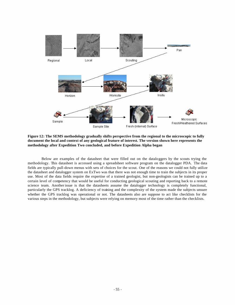
- 55 -
Figure 12: The SEMS methodology gradually shifts perspective from the regional to the microscopic to fully document the local and context of any geological feature of interest. The version shown here represents the methodology after Expedition Two concluded, and before Expedition Alpha began
Below are examples of the datasheet that were filled out on the dataloggers by the scouts trying the methodology. This datasheet is accessed using a spreadsheet software program on the datalogger PDA. The data fields are typically pull-down menus with sets of choices for the scout. One of the reasons we could not fully utilize the datasheet and datalogger system on ExTwo was that there was not enough time to train the subjects in its proper use. Most of the data fields require the expertise of a trained geologist, but non-geologists can be trained up to a certain level of competency that would be useful for conducting geological scouting and reporting back to a remote science team. Another issue is that the datasheets assume the datalogger technology is completely functional, particularly the GPS tracklog. A deficiency of training and the complexity of the system made the subjects unsure whether the GPS tracklog was operational or not. The datasheets also are suppose to act like checklists for the various steps in the methodology, but subjects were relying on memory most of the time rather than the checklists.

- 56 -
ExTwo : SEMS Study
Map Perspective Enter Region Name:
HabSite
Enter Names of all WorkSites in this Region to be visited this day
Arwen Bombadil Gandalf Gimli Haldir Legolas Meridoc Pippin Samwise
Enter Coords for all Worksites in this Region (UTM)
Link to GPS track log
Enter Terrain Sample ID
SEMS User Name Rocky Partner Names Rocky Phill Steve Map Type: Satellite Link to Files Map Scale: Datum: WGS84 Sync camera clock with GPS clock
yes Link to Files
Mark North Direction on Map
yes Link to Files
Field Maps Annotated?
No / None Link to Files
Additional Notes none Link to Files
Table 3: Expedition Two version of the SEMS datasheet for the Map Perspective.

- 57 -
ExTwo : SEMS Study
Panoramic Perspective Before pan image is taken: User Name 0 Partner with Additional
Data:
Region Name 0 WorkSite Name 0 WorkSite Target Coords Pan Image Coords Link to GPS track log or photo of GPS Photograph image of GPS unit that displays time
Link to Files
Take pan image: Link to Files Take image starting at cardinal direction N in a clockwise direction
Link to Files
Annotate cardinal directions on image.
Link to Files
Note possible future field research within pan image perspective (Stratigraphy, Biology, Lithology, Structural, Volcanic, Geophysical)
Link to Files
Note possible future specific research within pan image perspective
Link to Files
Note possible future research within pan image perspective quadrate (NE, SE, SW, NW)
Link to Files
Additional Notes
Link to Files
Table 4: Expedition Two version of the SEMS datasheet for the Panoramic Perspective.

- 58 -
ExTwo : SEMS Study
Regolith-Terrain Mapping Datasheet User Name 0 Partner with Additional
Data:
Region Name 0
WorkSite Name 0 WorkSite Target Coords
Local Terrain Coords Link to GPS track log or photo of GPS
Samples Link to Files
Landform Type Regolith Materials Surface induration, crusts and efflorescence
Symbols (drawn on local aerial map) Drainage ->- - - (arrow points down flow direction) Ridge line -X---X---X- (top of ridge) Hill top X Escarpment or breakway -v---v---v- (v is on the lower side) Spring o~ Sample o (sample location) Additional Notes Link to Files
Table 5: Expedition Two version of the SEMS datasheet for the recording Regolith-Terrain classifications.

- 59 -
ExTwo : SEMS Study Horizon Perspective User Name 0 Partner with Additional
Data:
Region Name 0 WorkSite Name 0 WorkSite Target Coords Horizon Image Coords Link to GPS track log or photo of GPS Feature Type to Investigate Photo with Horizon in view Link to Files Photo scale (meters). Use Jacob's staff or person if you note height
Additional Note Link to Files Direction UTM Datum Use Regolith-Terrain Methodology here
Additional Notes Link to Files
Table 6: Expedition Two version of the SEMS datasheet for the Horizon Perspective.

- 60 -
ExTwo : SEMS Study Outcrop Perspective The RST should be able to identify within this perspective image where the sample is taken:
User Name 0 Partner with Additional
Data:
Region Name 0 WorkSite Name 0 WorkSite Target Coords
Outcrop Coordinates Link to GPS track log or photo of GPS Enter Outcrop Sample IDs (different than RT-sample IDs):
1 2 3 4 5 6 Annotation or marker (aka rock hammer) of where sample taken.
Link to Files
Image of local feature closer than in Horizon but with outcrop as the focus.
Link to Files
Photo scale (meters). Use Jacob's staff or person if you note height
Additional Note Link to Files
Note Cardinal direction of image. Datum WGS84 Primary Structures (Fill these on Stratigraphy Datasheet if strata are present, otherwise fill below )
Additional Notes Fluvial Bedforms and Cross-Stratification
Link to Files
Bedforms due to Waves and Tides
Link to Files
Bedding and Grain Orientation
Link to Files
Dessication and Evaporation Structures
Link to Files
Erosional Structures Link to Files Biological Deposits Link to Files Bioturbation Structures Link to Files Water Escape Features Link to Files Apply Stratigraphy Methodology if applicable.
Link to Files
Table 7: Expedition Two version of the SEMS datasheet for the Outcrop Perspective.

- 61 -
ExTwo : SEMS Study Stratigraphy Datasheet User Name 0 Partner with
Additional Data:
Region Name 0 WorkSite Name 0 WorkSite Target Coords
Outcrop Coordinates
Link to GPS track log
Equipment needed: Jacob's Staff and Compass-Clinometer Use SEMS to the outcrop perspective. Measuring from the base of the outcrop (or section) to the top of the outcrop using above equipment, detail and document geological descriptions while ascending the outcrop (or section) using the following methodology for each stratigraphic unit.
Use Lithology Datasheet for each layer
Copy columns for additional units Primary Structures
Additional Notes
Unit ID:
Unit Thickness Link to Files
Is this the highest unit? Fluvial Bedforms and Cross-Stratification
Link to Files
Bedforms due to Waves and Tides
Link to Files
Bedding and Grain Orientation
Link to Files
Dessication and Evaporation Structures
Link to Files
Erosional Structures
Link to Files
Biological Deposits
Link to Files
Bioturbation Structures
Link to Files
Water Escape Features
Link to Files
Conformities Link to Files
Disconformities Link to Files
Unconformities Link to Files
Cliff, ledge or slope forming beds
Link to Files
Samples Acquired (use In Situ, Sample and Sample Site DataSheets)
(Enter IDs on OutCrop datasheet) Sample ID:
Additional Notes
Link to Files
Table 8: Expedition Two version of the SEMS datasheet for Stratigraphy observations.
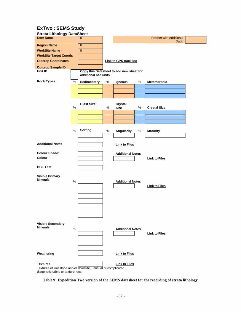
- 62 -
ExTwo : SEMS Study Strata Lithology DataSheet User Name
0
Partner with Additional
Data:
Region Name 0 WorkSite Name 0 WorkSite Target Coords Outcrop Coordinates Link to GPS track log Outcrop Sample ID Unit ID
Copy this Datasheet to add new sheet for additional bed units
Rock Types: % Sedimentary % Igneous % Metamorphic
% Clast Size:
% Crystal Size % Crystal Size
% Sorting: % Angularity % Maturity Additional Notes Link to Files Colour Shade: Additional Notes Colour: Link to Files HCL Test Visible Primary Minerals % Additional Notes Link to Files
Visible Secondary Minerals % Additional Notes Link to Files
Weathering Link to Files Textures Link to Files Textures of limestone and/or dolomite, unusual or complicated diagenetic fabric or texture, etc.
Table 9: Expedition Two version of the SEMS datasheet for the recording of strata lithology.

- 63 -
ExTwo : SEMS Study In Situ Perspective User Name 0 Partner with Additional
Data:
Region Name 0 WorkSite Name 0 WorkSite Target Coords Outcrop Coordinates Link to GPS track log Outcrop Sample ID Image of sample with surrounding environment closer than Outcrop perspective.
Link to Photo
Note scale in metric (use ruler) Image Direction IF stratigraphy datasheet not used, then note Primary Features below. Primary Structures Additional Notes Fluvial Bedforms and Cross-Stratification
Link to Files
Bedforms due to Waves and Tides
Link to Files
Bedding and Grain Orientation
Link to Files
Dessication and Evaporation Structures
Link to Files
Erosional Structures Link to Files Biological Deposits Link to Files Bioturbation Structures Link to Files Water Escape Features Link to Files Additional Notes Link to Files
Table 10: Expedition Two version of the SEMS datasheet for the In-Situ Perspective.

- 64 -
ExTwo : SEMS Study Sample Perspective User Name 0 Partner with Additional
Data:
Region Name 0 WorkSite Name 0 WorkSite Target Coords Outcrop Coordinates Link to GPS track log Outcrop Sample ID Take image of Sample (sample should fill view of camera with ruler):
Link to Files
Note Scale in metric (ruler numbers should also been visible within this image)
Link to Files
Use Lithology DataSheet Link to Files Additional Notes
Link to Files
Table 11: Expedition Two version of the SEMS datasheet for the Sample Perspective.
ExTwo : SEMS Study Sample Site Perspective User Name 0 Partner with Additional
Data:
Region Name 0 WorkSite Name 0 WorkSite Target Coords Outcrop Coordinates Link to GPS track log Outcrop Sample ID Take image of Sample Site after sample removed, using ruler in frame
Link to Files
Note Scale in metric (ruler numbers should also been visible within this image)
Link to Files
Use Lithology DataSheet Link to Files Additional Notes Link to Files
Table 12: Expedition Two version of the SEMS datasheet for the Sample Site Perspective.
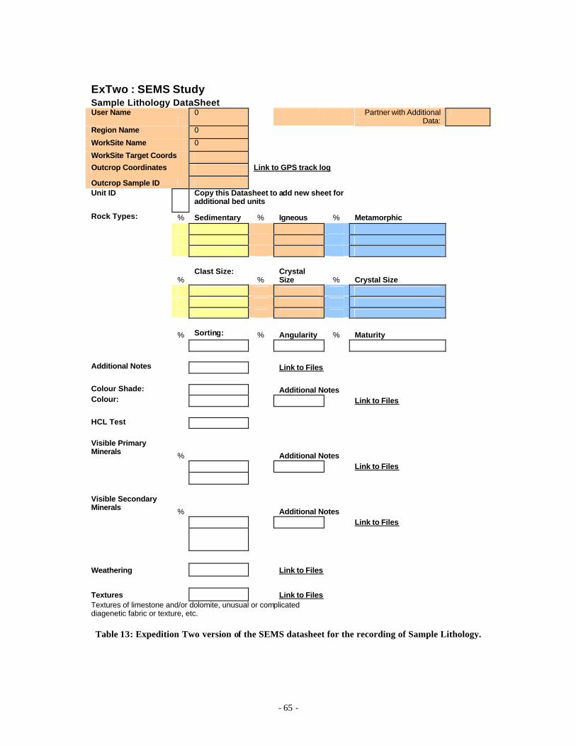
- 65 -
ExTwo : SEMS Study Sample Lithology DataSheet User Name
0
Partner with Additional
Data:
Region Name 0 WorkSite Name 0 WorkSite Target Coords Outcrop Coordinates Link to GPS track log Outcrop Sample ID Unit ID
Copy this Datasheet to add new sheet for additional bed units
Rock Types: % Sedimentary % Igneous % Metamorphic
% Clast Size:
% Crystal Size % Crystal Size
% Sorting: % Angularity % Maturity Additional Notes Link to Files Colour Shade: Additional Notes Colour: Link to Files HCL Test Visible Primary Minerals % Additional Notes Link to Files Visible Secondary Minerals % Additional Notes Link to Files
Weathering Link to Files Textures Link to Files Textures of limestone and/or dolomite, unusual or complicated diagenetic fabric or texture, etc.
Table 13: Expedition Two version of the SEMS datasheet for the recording of Sample Lithology.

- 66 -
ExTwo : SEMS Study Surfaces Perspective (Fresh versus External) User Name
0 Partner with Additional
Data:
Region Name 0 WorkSite Name 0 WorkSite Target Coords Outcrop Coordinates Link to GPS track log Outcrop Sample ID Take close up image of weathered (external) surface try to show as many minerals/structures as possible within image. Use ruler for scale
Note Scale in metric (ruler numbers should also been visible within this image.
Note Lithology (See Lithology Ck list) Break sample with rock hammer: Take close up image of fresh (internal) surface try to show as many minerals as possible within image. Use ruler for scale.
Note Scale in metric (ruler numbers should also been visible within this image.
Note Lithology (See Lithology Ck list) Additional Notes Link to Files
Table 14: Expedition Two version of the SEMS datasheet for the Surfaces Perspective.
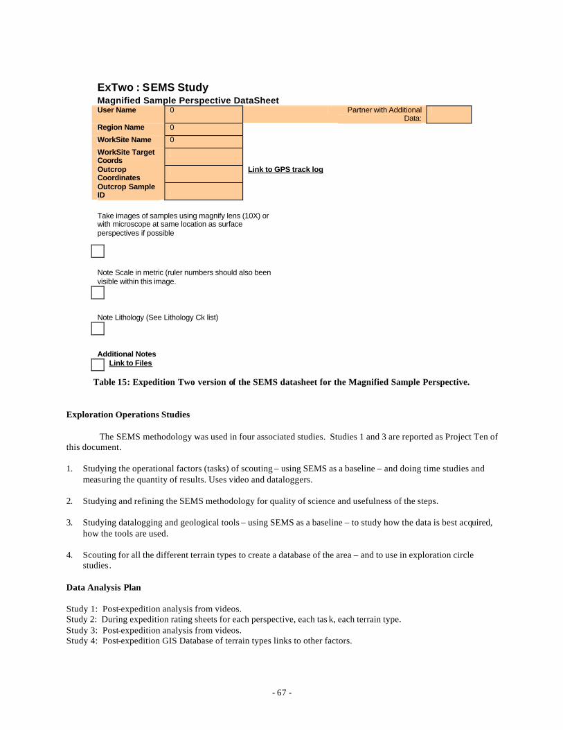
- 67 -
ExTwo : SEMS Study Magnified Sample Perspective DataSheet User Name 0 Partner with Additional
Data:
Region Name 0 WorkSite Name 0 WorkSite Target Coords
Outcrop Coordinates
Link to GPS track log
Outcrop Sample ID Take images of samples using magnify lens (10X) or with microscope at same location as surface perspectives if possible
Note Scale in metric (ruler numbers should also been visible within this image. Note Lithology (See Lithology Ck list) Additional Notes Link to Files
Table 15: Expedition Two version of the SEMS datasheet for the Magnified Sample Perspective.
Exploration Operations Studies
The SEMS methodology was used in four associated studies. Studies 1 and 3 are reported as Project Ten of this document.
1. Studying the operational factors (tasks) of scouting – using SEMS as a baseline – and doing time studies and measuring the quantity of results. Uses video and dataloggers.
2. Studying and refining the SEMS methodology for quality of science and usefulness of the steps.
3. Studying datalogging and geological tools – using SEMS as a baseline – to study how the data is best acquired, how the tools are used.
4. Scouting for all the different terrain types to create a database of the area – and to use in exploration circle studies.
Data Analysis Plan
Study 1: Post-expedition analysis from videos. Study 2: During expedition rating sheets for each perspective, each tas k, each terrain type. Study 3: Post-expedition analysis from videos. Study 4: Post-expedition GIS Database of terrain types links to other factors.
- 68 -
Conclusions
The issue of the datalogger is a question for Project Ten in this report, and therefore will be addressed in the next section.
The SEMS methodology improved over the course of Expedition Two, and the experience provided the researchers knowledge from which to direct the evolution of the study. In specific, the ambiguity of some perspectives areas were clarified by adding operational rules such as reporting bearing directions from a given panorama point to an outcrop or horizon being photographed. The datasheets were deemed too complex to use in the field, and furthermore, a problem because it took the eyes of the scout out the geology of the area and onto a dimly backlit computer screen.
The variety of the regolith-terrains (see appendix below) were expected to not vary very much in the Arkaroola region. Over the course of the expedition there were about 4 regolith-terrain types documented by the scouts, though there were more available . Similar studies using SEMS and time-motion studies will need to be conducted at other location to acquire a dataset on the complete range of regolith-terrain types.
Future Directions
Expedition Three through Six will complete the linking of operational data to terrain types, remote sensing types, and research-specific studies, explored at each Mars analog site.
All SEMS and the related operational studies should be completed before Expedition Seven, including each SEMS method specific to science-goals. For ExSeven, we use the final version of SEMS, and then test out over 90 days how far we can push the exploration circle. During that we also study the social-psychological work strategies in trying to sustain that kind of exploration program. ExEight through ExTwelve, we try different work strategies for pushing the exploration circle. Then for ExThirteen through ExFifteen, the big holistic simulations, (one of 30 days, two of 500 days) we put it all together, using the final versions of the work strategies.
Note: the following appendix is included to show the simple geological classification procedures employed for one aspect of the SEMS methodology.
APPENDIX: REGOLITH-LANDFORM MAPPING FOR THE ARKAROOLA FIELD AREA
Jonathan Clarke
Introduction
Regolith is everything between fresh rock and fresh air and comprises the land surface of the earth and all planetary bodies with a solid surface. Regolith landform mapping is a way of describing the landscape that captures the landforms, materials of which it is made, and any secondary induration. It is a useful tool for soil mapping, environmental geology, geomorphology mapping, regolith studies, planetary exploration, land systems mapping, soil ecology, groundwater studies, and mineral exploration. Key references for regolith studies include Taylor and Eggleton (2001)147, Ollier and Pain (1996)148 and Eggleton (2002)149.
For the Arkaroola Mars Analogue Region the system is based on that developed for use at MDRS in Utah (Clarke and Pain 2004)150, with appropriate expansion editing to reflect the specific features of the local environment. The methodology is developed from that of Pain et al. (2004)151, which is the Australian standard.
Methodology
The method has been optimized at two scales: map and site specific scale. At both scales each regolith landform unit is captured by three main descriptors. These consist of:
A landform descriptor in lower case letters
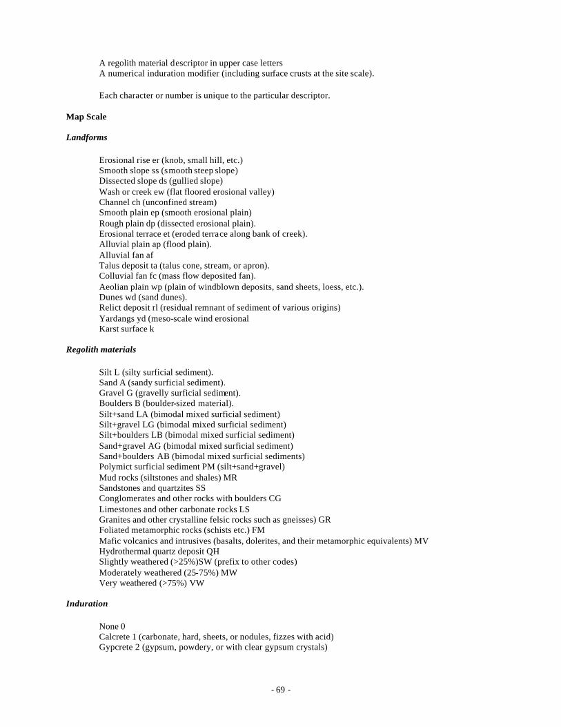
- 69 -
A regolith material descriptor in upper case letters A numerical induration modifier (including surface crusts at the site scale).
Each character or number is unique to the particular descriptor.
Map Scale
Landforms
Erosional rise er (knob, small hill, etc.) Smooth slope ss (smooth steep slope) Dissected slope ds (gullied slope) Wash or creek ew (flat floored erosional valley) Channel ch (unconfined stream) Smooth plain ep (smooth erosional plain) Rough plain dp (dissected erosional plain). Erosional terrace et (eroded terrace along bank of creek). Alluvial plain ap (flood plain). Alluvial fan af Talus deposit ta (talus cone, stream, or apron). Colluvial fan fc (mass flow deposited fan). Aeolian plain wp (plain of windblown deposits, sand sheets, loess, etc.). Dunes wd (sand dunes). Relict deposit rl (residual remnant of sediment of various origins) Yardangs yd (meso-scale wind erosional Karst surface k
Regolith materials
Silt L (silty surficial sediment). Sand A (sandy surficial sediment). Gravel G (gravelly surficial sediment). Boulders B (boulder-sized material). Silt+sand LA (bimodal mixed surficial sediment) Silt+gravel LG (bimodal mixed surficial sediment) Silt+boulders LB (bimodal mixed surficial sediment) Sand+gravel AG (bimodal mixed surficial sediment) Sand+boulders AB (bimodal mixed surficial sediments) Polymict surficial sediment PM (silt+sand+gravel) Mud rocks (siltstones and shales) MR Sandstones and quartzites SS Conglomerates and other rocks with boulders CG Limestones and other carbonate rocks LS Granites and other crystalline felsic rocks such as gneisses) GR Foliated metamorphic rocks (schists etc.) FM Mafic volcanics and intrusives (basalts, dolerites, and their metamorphic equivalents) MV Hydrothermal quartz deposit QH Slightly weathered (>25%)SW (prefix to other codes) Moderately weathered (25-75%) MW Very weathered (>75%) VW
Induration
None 0 Calcrete 1 (carbonate, hard, sheets, or nodules, fizzes with acid) Gypcrete 2 (gypsum, powdery, or with clear gypsum crystals)
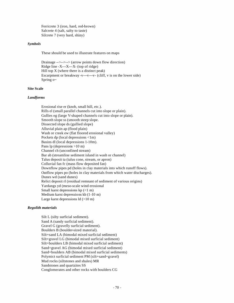
- 70 -
Ferricrete 3 (iron, hard, red-brown) Salcrete 4 (salt, salty to taste) Silcrete 7 (very hard, shiny)
Symbols
These should be used to illustrate features on maps
Drainage -->-->--> (arrow points down flow direction) Ridge line -X---X---X- (top of ridge) Hill top X (where there is a distinct peak) Escarpment or breakway -v---v---v- (cliff, v is on the lower side) Spring o~
Site Scale
Landforms
Erosional rise er (knob, small hill, etc.). Rills el (small parallel channels cut into slope or plain). Gullies eg (large V-shaped channels cut into slope or plain). Smooth slope ss (smooth steep slope. Dissected slope ds (gullied slope) Alluvial plain ap (flood plain) Wash or creek ew (flat floored erosional valley) Pockets dp (local depressions <1m) Basins dl (local depressions 1-10m). Pans lp (depressions >10 m) Channel ch (unconfined stream) Bar ab (streamline sediment island in wash or channel) Talus deposit ta (talus cone, stream, or apron) Colluvial fan fc (mass flow deposited fan) Downflow pipes pd (holes in clay materials into which runoff flows). Outflow pipes po (holes in clay materials from which water discharges). Dunes wd (sand dunes) Relict deposit rl (residual remnant of sediment of various origins) Yardangs yd (meso-scale wind erosional Small karst depressions kp (<1 m) Medium karst depressions kb (1-10 m) Large karst depressions ld (>10 m)
Regolith materials
Silt L (silty surficial sediment). Sand A (sandy surficial sediment). Gravel G (gravelly surficial sediment). Boulders B (boulder-sized material). Silt+sand LA (bimodal mixed surficial sediment) Silt+gravel LG (bimodal mixed surficial sediment) Silt+boulders LB (bimodal mixed surficial sediment) Sand+gravel AG (bimodal mixed surficial sediment) Sand+boulders AB (bimodal mixed surficial sediments) Polymict surficial sediment PM (silt+sand+gravel) Mud rocks (siltstones and shales) MR Sandstones and quartzites SS Conglomerates and other rocks with boulders CG
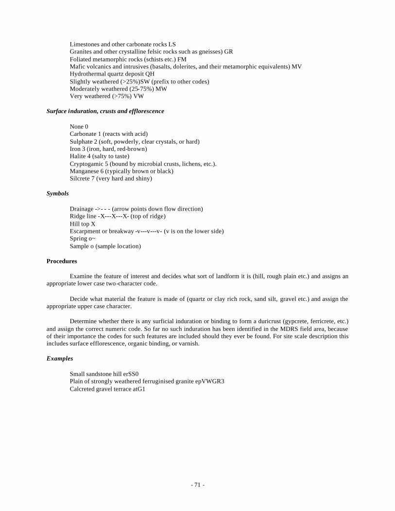
- 71 -
Limestones and other carbonate rocks LS Granites and other crystalline felsic rocks such as gneisses) GR Foliated metamorphic rocks (schists etc.) FM Mafic volcanics and intrusives (basalts, dolerites, and their metamorphic equivalents) MV Hydrothermal quartz deposit QH Slightly weathered (>25%)SW (prefix to other codes) Moderately weathered (25-75%) MW Very weathered (>75%) VW
Surface induration, crusts and efflorescence
None 0 Carbonate 1 (reacts with acid) Sulphate 2 (soft, powderly, clear crystals, or hard) Iron 3 (iron, hard, red-brown) Halite 4 (salty to taste) Cryptogamic 5 (bound by microbial crusts, lichens, etc.). Manganese 6 (typically brown or black) Silcrete 7 (very hard and shiny)
Symbols
Drainage ->- - - (arrow points down flow direction) Ridge line -X---X---X- (top of ridge) Hill top X Escarpment or breakway -v---v---v- (v is on the lower side) Spring o~ Sample o (sample location)
Procedures
Examine the feature of interest and decides what sort of landform it is (hill, rough plain etc.) and assigns an appropriate lower case two-character code.
Decide what material the feature is made of (quartz or clay rich rock, sand silt, gravel etc.) and assign the appropriate upper case character.
Determine whether there is any surficial induration or binding to form a duricrust (gypcrete, ferricrete, etc.) and assign the correct numeric code. So far no such induration has been identified in the MDRS field area, because of their importance the codes for such features are included should they ever be found. For site scale description this includes surface efflorescence, organic binding, or varnish.
Examples
Small sandstone hill erSS0 Plain of strongly weathered ferruginised granite epVWGR3 Calcreted gravel terrace atG1
- 72 -
PROJECT TEN: Astronaut EVA Dataloggers for Scouting Mars
Rocky Persaud and Stacy Sklar
Introduction
For Expedition Two, we used off the shelf technology to produce a fully functional datalogger that was used for tests of scouting operations procedures. Note that the datalogger was not the focus of the study, but just a tool to aid the study of scouting operations. MSC's current plan is to pursue the refinement of surface operations using off the shelf technology before investing in a technology development program to build a custom datalogger. With this approach we can refine procedures and software to optimize for Mars scouting operations rather than get bogged down in hardware development.
The Expedition Two version of the datalogger consists of separate components that are not fully integrated, but together provide the full dataset required for documentation of scouting data. This consisted of a Minolta DiMAGE Z1 for photos and video; an iPAQ 4350 for notetaking via typed notes and voice records on a Pocket PC 2003 platform, as well as the ArcPAD GIS software to read the incoming GPS information transmitted from the Pharos GPS receiver via Bluetooth to the iPAQ; an electronic labeller for providing in the field sample labels; and several pieces of non-electronic gear such as photo loupes, compass-clinometers, jacob’s staffs, and rock hammers.
We found the photo loupe an adequate substitute for an in-situ 10x microscope, and the compass-clinometer to be invaluable for properly spacing photos that would be stitched together for panoramic views. The Suunto Global Matchbox compass-clinometer is usuable in all magnetic zones in the world, so ideal for taking to any Mars analog station.
On the software side is the GPS-Photo Link software, that allow the photos to be stamped with titles, captions, time, date, and GPS coordinates, as well as produce webpages of the photo data with all the captions automatically included, links to satellite data providing global and regional context for the images, and all photos thumbnailed and indexed; the Panoramic Factory software to stitch panoramas together for 12 separate stills spaced 30 degrees apart; a spreadsheet software for the iPAQ to tabulate data and provide checklists in the field; and ArcPAD to provide GIS mapping capabilities in the field.
In the future MSC plans to produce custom software to provide the functionality of all these software programs in one package.
MSC was able to purchase three copies of all the hardware so that we had three dataloggers for Expedition Two. These were later used for a training mission at the Mars Desert Research Station called Expedition Alpha (Crew 30 at MDRS) and is intended to be used for any near-term future expeditions we plan.
In order to test out the dataloggers, this project was conducted using the Scouting Exploration Methodology (SEMS) of Project Nine.
Research Objectives
The research objective of the datalogger project were:
1. Assess the functionality of astronaut EVA dataloggers for scouting operations. This was performed by subjects rating each of the following tasks:
a. Photography b. Text annotation c. Voice annotation d. GPS annotation e. Feature Measurement f. Feature Description

- 73 -
g. Feature Mapping / Drawing h. Feature Sampling i. Operational Query j. Operational Description
2. Assess the ergonomic requirements of astronaut EVA dataloggers for scouting operations. This was performed by subjects rating each of the following tools:
a. Datasheets (PDA) b. Camera c. GPS d. Audio recorder (PDA) e. Hand lens f. Photo loupe g. Compass/clinometer h. Sample bags i. Sample labeller j. Geology hammer k. Hand scale l. Jacob’s staff m. Note pad n. Acid Bottle o. Other tool
3. Assess the “science return” from each scale of the SEMS perspective, given the prescribed datalogger operations, with the following questions:
a. Can the data be used to produce a traditional geology report? b. Does this data produced sufficient information on the Geological settings and environments? c. Can facies maps be produced? d. Can Structual Basin Maps be produced when this data is place into a GIS? e. Does this data help Develop an understanding of the variety of regolith in the area? f. Does this data help Develop a detailed understanding of the stratigraphy and structures of the region? g. Does this data help Develop an understanding of the depositional and diagenetic history of the
succession? h. Does this data help Develop an understanding of igneous processes in the region? i. Does this data help Develop an understanding of the landscape history? j. Does this data help Develop an understanding of the water chemistry in the area?
Observations
Geologists (on ExTwo and on missions at MDRS and FMARS prior to ExTwo) are remarkably resistant to using the SEMS methodology. Considering that it is primarily a method to aid the scouting of sites for geological interest, that is worrisome. Non-geologists seem to have no problem with its systematic method for documenting observations.
A strict methodology is needed for the Remote Science Team to acquire all the data it needs for its studies, and to obtain an adequate situational context for the rocks and geologic formations observed. A flexible methodology is needed for the Field Team geologists to allow them to work in the way that is most natural to their way of thinking. With adequate training, the method can be used effectively by anyone, providing the technology does not fail. The resistance is likely due to inadequate training of the test subjects and inadequate explanation to them of the purpose and scope of the study.
The preferred method all of the SEMS team for descriptive observation documentation is the use of voice notes. Relying solely on written notes is difficult and not enjoyed by the crew except in certain instances. Particularly valuable is the use of written notes for organizing a work strategy, and recording how many (and
- 74 -
typically in which bearing direction) photos were taken, so as to prepare and organize thoughts for a proper voice note comment.
On the August 6th trial, three subjects filled out operational reports that rated the effectiveness of the 10 tasks, the usefulness of the 15 tools, and the science return of 10 goals as described above. The datasets acquired from these ratings are not enough to conclude statistical trends, so future trials will need to be done.
On August 13th, one trial of the SEMS using the datalogger was conducted where the objective was to return to the Habsite region near Arkaroola Spring in order to repeat trials from August 6th with alternative data recording methods in a time and effectiveness study. This comparative study trialed the use of a voice recorder (on the iPAQ 4350), typed notes (on the iPAQ) entered into a spreadsheet, and notes written on a notepad. The same features were repeatedly documented in trials for each of the three note annotation methods, in order to measure the length of time for each to understand how much an advantage one had over another.
At this point in the trials, the naming convention was inconsistently used for pan points and outcrops. In later trials, only pan points would be named worksites, and outcrops viewed from it would be numbered (initially numerically in order, later simply by bearing direction from the pan point). This evolution of the methodology was deemed preferable for the short term development of the project, but an area where technological solutions might prove useful in the future.
On August 22nd, the datalogger equipment was used while wearing the MarsSkin analog suit. The suit did not noticably encumber the field team from documenting sites according to the SEMS methodology, though the datalogger equipment use was somewhat slowed. A quantitative analysis of the difference will be published elsewhere. For the time-motion study Rocky Persaud photographed Phill Krins scouting site “Boba Fett”. Rocky took photos of significant events and processes during the scouting (walking to sites, start and stop of panoramic photo documentation, outcrop documentation, and sample documentation, and use of compass, notepad, hammer, iPAQ, photo loupe, Jacob's staff, etc.) and some photographs of the positioning of equipment in the pockets and clips of the MarsSkin. Another time -motion study was conducted at the Black Spring area without the MarsSkins.
Trials of the dataloggers in addition to those reported above were conducted, and await analysis.
Conclusions
The datalogger project is developing well in parallel with the study of scouting operations (SEMS). The huge amount of data now acquired not only from Expedition Two, but from Expedition One and Expedition Alpha, will allow a careful analysis of the basic issues regarding scouting operations and datalogger functionality, and the evolution of hardware and software for these projects.
The issue of using the datalogger in conjunction with the scouting methodology as two parallel studies may be confusing some of the test subjects, particularly geologists not used to examining geological questions in this manner. Resistance to the scouting methodology must be understood before deciding future directions for the datalogger development program.
- 75 -
PROJECT ELEVEN: Mechanical -Counter-Pressure Gloves and Spacesuits for the MarsSkin Project
James Waldie and Natalie Cutler
Introduction
The Expedition Two research program included projects such as the MarsSkin Mechanical-Counter-Pressure Suit and Glove Analog which were continued directly from Expedition One. Therefore, an original proposal was not required from the researchers by the Mars Expedition Research Council. The follow background, taken from the Expedition One summary paper, is included for reference.
The background below makes mention of the MarsSkin 2 analog suit used on Expedition One. The MarsSkin 3 analog suit used on Expedition Two upgraded the skin-tight inner elastic layer, the backpack, and the helmet, only keeping the outer dust layer the same as the MarsSkin 3.
Two studies were conducted using the MarsSkin 3: a field of view study, and glove dexterity study.
Background
Space suits are a vital aspect of every EVA. As such, the performance of the suit is essential to a successful manned mission to Mars. Current spacesuits may not be used on Mars due primarily to flexibility and weight issues. Mechanical Counter-Pressure suits152, however, may be used due to their superiority in these and other areas. While new MCP developments have produced effective gloves, the practical advantage over conventional gas -filled gloves is yet to be explored. Expedition One offered the chance to study a new MCP glove and simulation MCP suits in a Mars-analog context. It also offered the chance to analyze suit function as a stand-alone product and as an element which must integrate into other technologies of the mission.
1. Current MCP developments have produced a functioning glove, one of which is available. The ability to perform tasks with the MarsSkin glove and the Honeywell glove can be compared to determine the success of the analog glove. Some experiments will be carried out beforehand, such as mobility, dexterity and finger deflection studies, but this mission offers the chance to explore the glove function in very realistic tasks. The glove, of course, is the most vital aspect in providing functionality to an astronaut and so the focus on hand studies is highly relevant and a key indicator for the whole suit.
2. Every aspect of suit usage should be understood, and data formed on how the suit affects the astronauts abilities. From the moment of donning, through mission activities, until doffing and stowage, the suit is an integral and vital aspect of EVA. Hundreds of questions can be raised, covering topics of glove flexibility, suit flexibility, data logger issues, suit durability, helmet visibility and performance, Personal Utility Life Support System (PULSS) backpack performance etc. Through first and third person experience, these aspects can be attained.
3. With gathered data/knowledge/opinion, improvements can be analyzed in both the suit and other technologies. This step is designed to optimize the suit, and optimize the interaction of the suit with other technologies. For example, what minimum diameter should all handles be on tools? What size buttons should be used (on the suit and other EVA devices), and what spacing should be allowed between each? These extrapolations can then be used to create a database of knowledge for future suit and mission design.
Expedition One allowed for the comparison between 2 different analog suits: the standard Mars Desert Research Station (MDRS) suit (which simulated current gas-bag technology) and the MarsSkin 2 suit (which simulated elastic skin suit technology, or mechanical counter-pressure). The MarsSkin suits were found to be less bulky and more comfortable to wear. The visibility afforded by the helmets was also far greater than the MDRS helmets due to the fact that the helmet (and therefore the visor) moved with the head and eye-line. The pockets on the MarsSkin were easily viewable by the wearer - impossible in the MDRS suits. Overall, these factors allowed EVA astronauts to walk, climb and ride the ATVs more effectively (and safely) than the standard suits, while also allowing sampling and scouting to be easier and more efficient. The MarsSkin backpack was much smaller than the MDRS suit, primarily because it did not have a ventilation system to the helmet and a suitably sized analog breathing system. Backpack weights between the MDRS and MarsSkin suits were similar, however, due to the
- 76 -
laptop computer datalogger systems carried by the MarsSkins. The helmet ventilation deficiency of the MarsSkins caused breathing troubles with some wearers despite some natural airflow through the helmet as they were not perfectly air-tight. The helmet, while offering much better visibility, was deemed unrealistic due to the fact that it relied on a flexible (but gas-pressurized) neck section. Gas-pressurization would of course make such a section stiff. Future MarsSkin versions will require the traditional fishbowl style helmet, which will also increase the perception for the wearer of donning a true pace suit style garment. Improvements to the accuracy of the backpack will also need to be made.
The gloves were a particular issue to the EVA astronauts: the MDRS gloves were big and bulky, while the MarsSkin gloves were more form-fitting. A study was performed to measure the performance of these gloves and others to attempt to quantify the difference. Simple repeatable tasks in biology, engineering, typing and geology were performed (with prior familiarization) by at least 6 subjects with the naked hand, the MDRS gloves, the two versions of MarsSkin gloves (wetsuit style and liner/outer) and actual MCP gloves and outer. The MDRS gloves were found to be about 2.7 times slower than the naked hand (average for all tests), while the actual MCP gloves were about 1.6 times slower. Of the two MarsSkin gloves, the liner/outer combination was found to be the better mimic at about 1.5 times slower than the naked hand. Of the four tests, the geology test of picking up and bagging rock samples was impacted the most by glove type, while the biology test of scooping soil into a beaker was found to offer the least variation.
Field Report
During Expedition Two, the MarsSkin team (James Waldie, Natalie Cutler) proposed to conduct an extended study into the impact of different types of EVA suit gloves on astronaut performance. Prior to the expedition, students from the University of Technology Sydney (UTS) Geology Department contacted the MarsSkin team to discuss participation in this research.
In the evening of Tuesday 3rd August James and Natalie met with the students to discuss proposals for experimental tasks to be performed by the test subjects. Three tests were collaboratively designed, requiring varying degrees of dexterity, touch sensitivity and glove flexibility:
• Sample bagging – Subjects were asked to sort and bag rock samples. This involved handling rocks of a variety of sizes and shapes, as well as sealing several zip- lock plastic bags.
• Brunton measurement – Subjects were required to remove a Brunton instrument from its leather pouch, align it to a surface and perform a fine adjustment to centre a spirit level bubble so that surface inclination could be measured (note that actual measurement was not part of the task).
• Maintenance Task – This task was performed in two parts. In the first part, subjects were required to pick up a nut and screw it to the base of a bolt fixed to the horizontal surface. The second part was to pick up both a nut and a bolt and screw the nut to the base of the bolt.
The time taken to complete each task was to be recorded for each of the following:
• Naked Hand
• Gas-pressurised glove analog – simulated by a ski glove treated with fabric stiffener. This has been found in previous studies to be a good analog for the current gas-filled space suit glove.
• Mechanical Counter Pressure (MCP) glove analog – simulated by a Mountain wear ‘Powerstretch’ glove, found in tests at MDRS to impact performance most similarly to the actual MCP glove. A cray-fishing glove was used as the outer protection layer.
In order to obtain a good test population, 40 students visiting Arkaroola from the International Space University volunteered to act as test subjects. After an initial briefing by James, testing was conducted over two evenings with the UTS students timing and organizing participants.
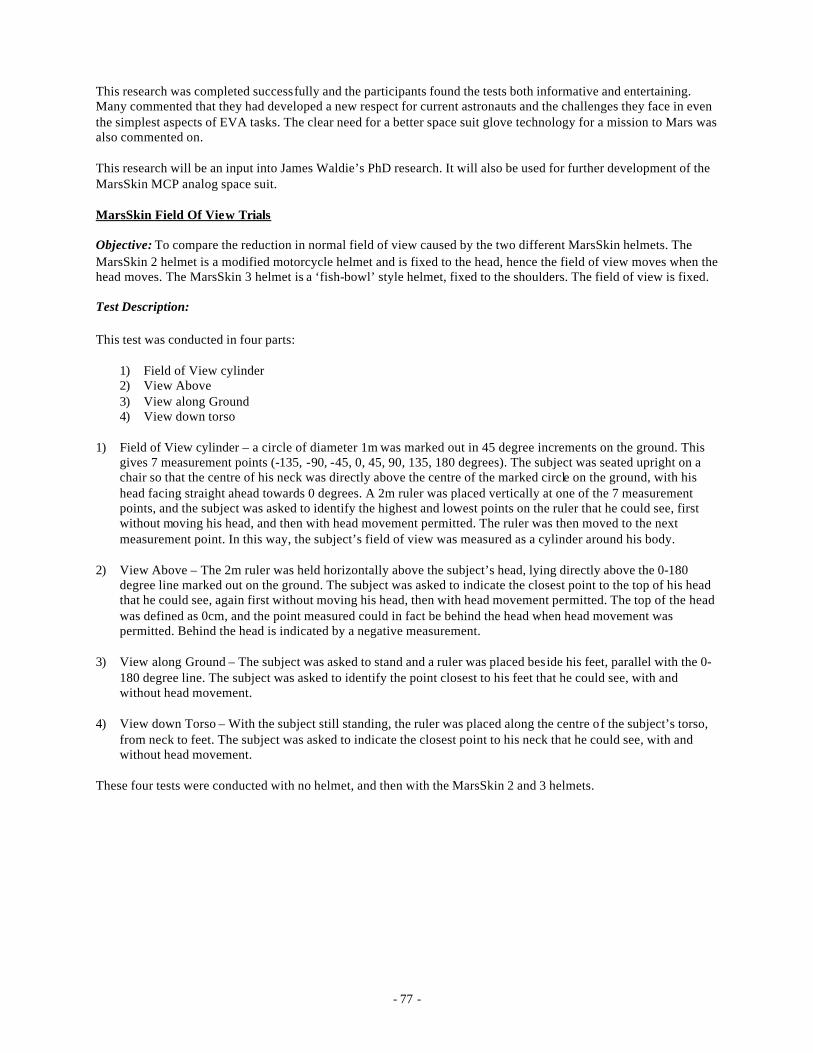
- 77 -
This research was completed successfully and the participants found the tests both informative and entertaining. Many commented that they had developed a new respect for current astronauts and the challenges they face in even the simplest aspects of EVA tasks. The clear need for a better space suit glove technology for a mission to Mars was also commented on.
This research will be an input into James Waldie’s PhD research. It will also be used for further development of the MarsSkin MCP analog space suit.
MarsSkin Field Of View Trials
Objective: To compare the reduction in normal field of view caused by the two different MarsSkin helmets. The MarsSkin 2 helmet is a modified motorcycle helmet and is fixed to the head, hence the field of view moves when the head moves. The MarsSkin 3 helmet is a ‘fish-bowl’ style helmet, fixed to the shoulders. The field of view is fixed.
Test Description:
This test was conducted in four parts:
1) Field of View cylinder 2) View Above 3) View along Ground 4) View down torso
1) Field of View cylinder – a circle of diameter 1m was marked out in 45 degree increments on the ground. This gives 7 measurement points (-135, -90, -45, 0, 45, 90, 135, 180 degrees). The subject was seated upright on a chair so that the centre of his neck was directly above the centre of the marked circle on the ground, with his head facing straight ahead towards 0 degrees. A 2m ruler was placed vertically at one of the 7 measurement points, and the subject was asked to identify the highest and lowest points on the ruler that he could see, first without moving his head, and then with head movement permitted. The ruler was then moved to the next measurement point. In this way, the subject’s field of view was measured as a cylinder around his body.
2) View Above – The 2m ruler was held horizontally above the subject’s head, lying directly above the 0-180 degree line marked out on the ground. The subject was asked to indicate the closest point to the top of his head that he could see, again first without moving his head, then with head movement permitted. The top of the head was defined as 0cm, and the point measured could in fact be behind the head when head movement was permitted. Behind the head is indicated by a negative measurement.
3) View along Ground – The subject was asked to stand and a ruler was placed beside his feet, parallel with the 0-180 degree line. The subject was asked to identify the point closest to his feet that he could see, with and without head movement.
4) View down Torso – With the subject still standing, the ruler was placed along the centre of the subject’s torso, from neck to feet. The subject was asked to indicate the closest point to his neck that he could see, with and without head movement.
These four tests were conducted with no helmet, and then with the MarsSkin 2 and 3 helmets.
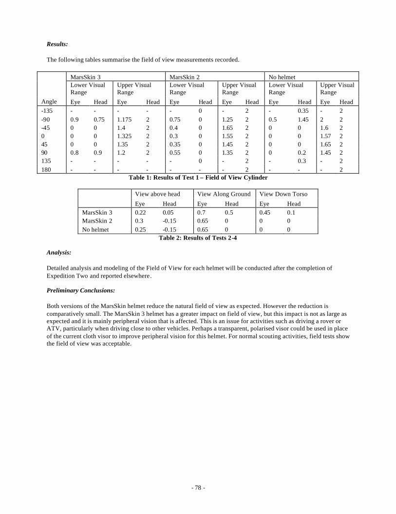
- 78 -
Results:
The following tables summarise the field of view measurements recorded.
MarsSkin 3 MarsSkin 2 No helmet Lower Visual Range
Upper Visual Range
Lower Visual Range
Upper Visual Range
Lower Visual Range
Upper Visual Range
Angle Eye Head Eye Head Eye Head Eye Head Eye Head Eye Head -135 - - - - - 0 - 2 - 0.35 - 2 -90 0.9 0.75 1.175 2 0.75 0 1.25 2 0.5 1.45 2 2 -45 0 0 1.4 2 0.4 0 1.65 2 0 0 1.6 2 0 0 0 1.325 2 0.3 0 1.55 2 0 0 1.57 2 45 0 0 1.35 2 0.35 0 1.45 2 0 0 1.65 2 90 0.8 0.9 1.2 2 0.55 0 1.35 2 0 0.2 1.45 2 135 - - - - - 0 - 2 - 0.3 - 2 180 - - - - - - - 2 - - - 2
Table 1: Results of Test 1 – Field of View Cylinder
View above head View Along Ground View Down Torso Eye Head Eye Head Eye Head MarsSkin 3 0.22 0.05 0.7 0.5 0.45 0.1 MarsSkin 2 0.3 -0.15 0.65 0 0 0 No helmet 0.25 -0.15 0.65 0 0 0
Table 2: Results of Tests 2-4
Analysis:
Detailed analysis and modeling of the Field of View for each helmet will be conducted after the completion of Expedition Two and reported elsewhere.
Preliminary Conclusions:
Both versions of the MarsSkin helmet reduce the natural field of view as expected. However the reduction is comparatively small. The MarsSkin 3 helmet has a greater impact on field of view, but this impact is not as large as expected and it is mainly peripheral vision that is affected. This is an issue for activities such as driving a rover or ATV, particularly when driving close to other vehicles. Perhaps a transparent, polarised visor could be used in place of the current cloth visor to improve peripheral vision for this helmet. For normal scouting activities, field tests show the field of view was acceptable.
- 79 -
OUTREACH AND EDUCATION
ISU
During phase 1 the Expedition Two crew spent three days interacting with the International Space University Summer Session Program. By the third day, the education aspects of the expedition had been completed. Both the field trip and presentations to the International Space University Summer School Program (ISU SSP) were very successful. On Tuesday night presentations were made about the goals of the expedition, MarsSkin and MARS-OZ by Jon Clarke, James Waldie, and David Willson. On Wednesday Vic Gostin and Jennifer Heldmann led the ISU students through an excursion of the Mt Painter Complex and adjacent areas to give them an appreciation of both the analog value of the area and to alert the students, nearly all of whom were from non-field-science backgrounds, to the sort of issues raised by both field research and surface exploration. In the evening exp editions contributed to a panel discussion with ISU faculty. Expedition Two was represented by Vic Gostin, Jennifer Heldmann, and Rocky Persaud. ISU was represented by Jim Burke and Sheryl Bishop. The sixth member of the panel was Graziella Caprarelli of the University of Technology Sydney (UTS). Fathi Karouia also assisted the panel in some specific questions with his expertise in radiation medicine.
UTS
A large group of staff and students from the University of Technology Sydney (UTS) led by Graziella Caprarelli joined us on the expedition orientation field trip to Paralana springs and adjacent sites on the Tuesday, and later accompanied those expeditioners who went to the Beverley mine visit. The students also assisted James Waldie and Nat Cutler in the glove trial experiments, which they documented on their website*.
PUBLIC NEWS MEDIA INTERACTIONS
Phase One
During the first week, the Expedition attracted the following media coverage:
• Dr. Jonathan Clarke - radio interview with Nance Haxton, ABC - 'Scientists target manned Mars mission' played on ABC Radio on 31 July 2004.
• Segment on Channel 10 TV news, August 1, 2004.
• Rocky Persaud & Steve Jordan - radio interview on 2 August 2004 with the ABC's 'Life Matters' program.
• James Waldie & Natalie Cutler - 'The designer suit for Mars' - article in The Sydney Morning Herald, August 5, 2004.
• James Waldie - 'Well-suited scientists set to see red in outback' - article in The Age, August 5, 2004.
• Dr. Jonathan Clarke, Dr. Jennifer Heldmann, James Waldie & Natalie Cutler - 'Outback road to the red planet' - article in the Adelaide Advertiser, August 5, 2004.
• Dr. Jonathan Clarke - Interview broadcast on Channel 7 TV news (4.30 pm), August 5, 2004.
• Dr. Jonathan Clarke - interview with 5AA radio
• Dr. Jonathan Clarke - interview with 5DN radio
* http://www.science.uts.edu.au/news/2004/mars.html
- 80 -
Phase Two
Week 2 of the Expedition has also saw a great deal of national media coverage, which is gratifying, given we operate on a shoestring when it comes to marketing, and cannot use paid advertising to get our message across to the public. The publicity about the need for finance for constructing and operating MARS-OZ, the proposed Australian Mars Research base in the Arkaroola region, will also help us (Mars Society Australia), we hope, to achieve our goal of a facility in the Outback, available to researchers from Australia and around the world, in one of the most Mars-like environments on Earth.
This week, logged media coverage was as follows:
• Natalie Cutler, Dr. Vic Gostin and Shannon Rupert-Robles - interview broadcast on Channel 10 TV news at 10.30 pm, 12 August, 2004.
• James Waldie, Natalie Cutler, Dr. Jennifer Heldmann, Dr. Jonathan Clarke, David Willson, Dr. Vic Gostin - 'Bar the location it could be Mars' - article in The Age newspaper, 13 August, 2004.
• Dr. Jonathan Clarke - 'Site chosen for Mars training lab' - article in ABC News Online, 13 August, 2004.
Both the ABC Stateline program and Channel 9's 'Today Show' sent crews up to Arkaroola to film activities and interview the crew.
Phase Three
This week saw the successful outcome of some of the PR work carried out by the crew during Phase 2. Several television segments and some newspaper articles contained interviews with the crew and radio interviews were carried out with local stations. This gave the expedition a solid profile across Australian media, and will hopefully encourage future sponsorship for the Expedition Mars program and MARS-OZ.
Logged media coverage was as follows:
• Natalie Cutler, Dr. Jonathan Clarke, Fathi Karouia, Phill Krins, Dr. Jennifer Heldmann, - Mars Research in Arkaroola broadcast on ABC TV Stateline program at 7.30 pm, 13 August, 2004.
• Natalie Cutler, Dr. Vic Gostin, Dr. Jennifer Heldmann, Phill Krins - South Australia part of mission to Mars, broadcast on ABC Radio's AM program, 8.28 am, 14 August 2004.
• Dr. Jonathan Clarke - Site chosen for Mars training lab, ABC News Online, 9.23 am, 14 August, 2004.
• Natalie Cutler, Dr. Jonathan Clarke, Shannon Rupert, Edward Martinez, Fathi Karouia - segment on Expedition Two broadcast on Channel 9 TV, A Current Affair program, 6.30 pm, 16 August, 2004.
• David Willson - Tassie role in mission to Mars project, article in the Mercury newspaper, 19 August 2004.
There were also discussions with several documentary companies and an Adelaide television station regarding the possibility of filming in Arkaroola during Phase 4.
Phase Four
This week, the final Phase of the Expedition, saw media attention die down somewhat, after a great deal of coverage on TV, radio and news media in Phase 3. A news-crew from Channel 7 came up on 26 August 2004 and interviewed Phill Krins and Jonathan Clarke about the Expedition.
Overall, we can be extremely satisfied with the breadth and quality of the media coverage of Expedition Two, with several major newspapers, four of the five free-to-air television stations, and radio stations carrying information about Expedition Two and its crew.

- 81 -
Highlights included:
• Front-page coverage, including a photo, in the Sydney Morning Herald;
• An in-depth segment on the renowned ABC Stateline TV program;
• Front page coverage, including a photo, in The Age’s supplementary feature.
Once the expedition was concluded, a press release on outcomes featuring some of the work of people like Dr. Steve Dawson and Phill Krins was distributed widely, including Canadian and other international media, focusing on work of some of the crew-members who visited Australia from overseas.
For reference the journalistic attention for Expedition One is reported below for comparison with the coverage for Expedition Two, as well as coverage relating to both expeditions.
EXPEDITION ONE MEDIA COVERAGE
Date Organization Type Featured 11/2/03 ABC Canberra (Australia) Radio Jonathan Clarke and Steve
Dawson, MSA 12/2/03 Today Show (Australia) TV James Waldie, MSA 24/2/03 Sydney Morning Herald (Australia) Newspaper Jennifer Laing, MSA 24/2/03 The Age (Australia) Newspaper Jennifer Laing, MSA 26/2/03 ABC Melbourne (Australia) Radio Robert Zubrin (MS) who spoke
about ExOne. 5/3/03 E=M6 (France) TV Entire Crew 9/3/03 L’Est Republicain (France) Newspaper Fathi Karouia, MS France 11/3/03 Space News (Canada) TV Entire Crew 20/3/03 Radio 2UE, Newcastle (Australia) Radio Jennifer Laing, MSA March 2003 (TBC) Ayr Journal News (Canada) Newspaper Melissa Battler, MS Canada
EXPEDITION ONE AND TWO MEDIA COVERAGE
Date Organization Type Featured 25/3/03 SpaceDaily (international) Web site Entire Crew 1/4/03 ABC Canberra (Australia)
Radio Jonathan Clarke and Steve
Dawson, MSA 3/4/03 Canberra Times (Australia) Newspaper Jonathan Clarke and Steve
Dawson, MSA 3/4/03 RMIT Magazine, RMIT University
(Australia) Campus Magazine James Waldie, MSA
4/4/03 Herald Sun (Australia) Newspaper James Waldie, MSA 5/4/03 Canberra Times (Australia) Newspaper Steve Dawson, MSA 10/4/03 ABC Hobart (Aus tralia) Radio James Waldie, MSA 13/4/03 Le Journal de Haute-Marne (France) Newspaper Fathi Karouia, MS France May 2003 Australian Embassy, Washington
Newsletter (USA) Newsletter James Waldie, MSA
June 2003 Australasian Science (Australia) Magazine Jonathan Clarke, MSA July/Sept 2003 Australian Geographic (Australia) Magazine Jonathan Clarke, MSA 11/6/03 ZIP FM, Nagoya (Japan) Radio James Waldie, MSA 7/7/03 Campus, University of Houston (U.S.A) Campus Magazine Fathi Karouia, MS France 17/7/03 4BC (Australia) Radio Jonathan Clarke, MSA July 2003 Today Show, Channel 9, (Australia) TV Graham Mann, MSA Sept 2003 ISU Alumni News Magazine Fathi Karouia, France 28/9/03 Sunday Mail SA (Australia) Newspaper Jonathan Clarke & Jennifer
Laing, MSA 28/9/03 The Mercury Tasmania Newspaper Jonathan Clarke, MSA 12/10/03 Sunday Mail QLD (Australia) Newspaper Jonathan Clarke, MSA TBC Discovery Science Channel – ‘Wild Tech’
series – ‘Future Shelter’ program Cable TV Steve Dawson, MSA
6/11/03 George Negus Tonight (Australia) TV Steve Dawson, MSA
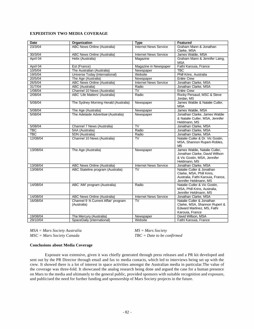
- 82 -
EXPEDITION TWO MEDIA COVERAGE
Date Organization Type Featured 23/3/04 ABC News Online (Australia) Internet News Service Graham Mann & Jonathan
Clarke, MSA 30/3/04 ABC News Online (Australia) Internet News Service James Waldie, MSA April 04 Helix (Australia) Magazine Graham Mann & Jennifer Laing,
MSA April 04 Est (France) Magazine in Newspaper Fathi Karouia, France 10/5/04 The Australian (Australia) Newspaper TBC 19/5/04 Universe Today (international) Website Phill Krins, Australia 20/5/04 The Age (Australia) Newspaper Entire Crew 26/5/04 ABC News Online (Australia) Internet News Service Jonathan Clarke, MSA 31/7/04 ABC (Australia) Radio Jonathan Clarke, MSA 1/08/04 Channel 10 News (Australia) TV Entire Crew 2/08/04 ABC ‘Life Matters’ (Australia) Radio Rocky Persaud, MSC & Steve
Jordan, MS 5/08/04 The Sydney Morning Herald (Australia) Newspaper James Waldie & Natalie Cutler,
MSA 5/08/04 The Age (Australia) Newspaper James Waldie, MSA 5/08/04 The Adelaide Advertiser (Australia) Newspaper Jonathan Clarke, James Waldie
& Natalie Cutler, MSA, Jennifer Heldmann, MS
5/08/04 Channel 7 News (Australia) TV Jonathan Clarke, MSA TBC 5AA (Australia) Radio Jonathan Clarke, MSA TBC 5DN (Australia) Radio Jonathan Clarke, MSA 12/08/04 Channel 10 News (Australia) TV Natalie Cutler & Dr. Vic Gostin,
MSA, Shannon Rupert-Robles, MS
13/08/04 The Age (Australia) Newspaper James Waldie, Natalie Cutler, Jonathan Clarke, David Willson & Vic Gostin, MSA, Jennifer Heldmann, MS
13/08/04 ABC News Online (Australia) Internet News Service Jonathan Clarke, MSA 13/08/04 ABC Stateline program (Australia) TV Natalie Cutler & Jonathan
Clarke, MSA, Phill Krins, Australia, Fathi Karouia, France, Jennifer Heldmann, MS
14/08/04 ABC ‘AM’ program (Australia) Radio Natalie Cutler & Vic Gostin, MSA, Phill Krins, Australia, Jennifer Heldmann, MS
14/08/04 ABC News Online (Australia) Internet News Service Jonathan Clarke, MSA 16/08/04 Channel 9 ‘A Current Affair’ program
(Australia) TV Natalie Cutler & Jonathan
Clarke, MSA, Shannon Rupert & Edward Martinez, MS, Fathi Karouia, France
19/08/04 The Mercury (Australia) Newspaper David Willson, MSA 29/10/04 SpaceDaily (international) Website Fathi Karouia, France
MSA = Mars Society Australia MS = Mars Society MSC = Mars Society Canada TBC = Date to be confirmed
Conclusions about Media Coverage
Exposure was extensive, given it was chiefly generated through press releases and a PR kit developed and sent out by the PR Director through email and fax to media contacts, which led to interviews being set up with the crew. It showed there is a lot of interest in space activities amongst the Australian media in particular.The value of the coverage was three-fold. It showcased the analog research being done and argued the case for a human presence on Mars to the media and ultimately to the general public, provided sponsors with suitable recognition and exposure, and publicised the need for further funding and sponsorship of Mars Society projects in the future.
- 83 -
Canadian Publicity and Outreach
Post-Expedition Canadian Mars Lecture Series
In Canada, the Mars Society of Canada conducted a nation-wide program of lectures to inform the public about the activities of the Mars Society, specifically highlighting the exp edition, and discussing Mars analog research, humans to Mars concepts, and Canadian industrial and scientific participation in space exploration, as led by the Canadian Space Agency. This lecture series was directly supported by the CSA as part of the contract for MSC to conduct Expedition Two.
The “Canada and Mars” lecture series took place from October 2004 to April 2005. Montreal, Waterloo, Fredrickton, Vancouver and Edmonton were the cities selected for this program due to having local MSC chapters available to organize the events. MSC purchased one of the MarsSkin suits from Mars Society Australia to aid in promotional efforts.
October 28, 2004 – Montreal, QC
Mars Society Canada, in conjunction with the Concordia University chapter of the Canadian Aeronautics and Space Institute (CASI), held a night of Mars related presentations. MSC and CASI were fortunate to have had presenting Dr. Erick Dupuis, the Canadian Space Agency's Mars Exploration Program Lead Engineer, as well as Fathi Karouia, a Ph.D candidate from the University of Houston and Expedition Two crewmember. Other activities included a showing of a video produced by Joan Roch, a Canadian who spent the 2004 summer fieldseason as a crewmember at the Mars Society's Flashline Mars Arctic Research Station; as well as a MarsSkin mechanical-counter-pressure analog spacesuit demonstration. The audience reportedly numbered somewhere around 120 participants, some of them students, some of them aerospace engineers and managers working in the Montreal area. The event drew media attention as well: Discovery Channel Canada conducted an interview with Fathi Karouia for their daily science news program. Rick Mercer of the CBC also interviewed him that day for the “Monday Report”, which despite being a humourous television program, brought positive attention to Mars Society Canada. The humourous aspects of the show were mainly of Rick Mercer wearing the MarsSkin suit and walking around in downtown Montreal at rush hour.
November 22, 2004 – Waterloo, ON
Mars Society Canada’s Waterloo chapter hosted an event at the University of Waterloo to publicize Expedition Two and inform the public about Mars activities by Canadians and the Canadian Space Agency. MSC Vice President and Expedition Two research manager Rocky Persaud presented a talk about how astronaut may go about scouting Mars on a human expedition to the red planet some day. Also on hand was Ken Pizzolitto, a physiology PhD graduate student who was selected to be on the crew of Expedition Alpha, to demonstrate the MarsSkin analog spacesuit. This attracted attention from the media, as reported below.
November 29, 2004 – Fredricton, NB
Mars Society Canada, in conjunction with the Fredericton Space Society, was pleased to host a night showcasing some of Canada’s recent activities related to the exploration of Mars, as well as talks on the evolution of the Moon, and the University of New Brunswick's Robotics and Mechanisms Laboratory. This event was held at UNB in Fredericton on Monday, November 29th, beginning at 5:30 PM. The event began with a presentation by Melissa Battler, M.Sc. Candidate at UNB’s Planetary and Space Science Centre, and Director of Events for Mars Society Canada. Melissa gave a presentation on Expedition Two and MSC’s Mars Analog Research Program. This was followed by a presentation by Dr. Juan Carretero, assistant professor at the Department of Mechanical Engineering at UNB, on Simulations of Space Robotics Systems. Dr. Carretero outlined the Canadian space robotics program, and then discussed the role that UNB plays in space robotics simulations. Director of the Planetary and Space Science Centre, and professor at the Geology Department of UNB Dr. John Spray then gave a presentation on Impact Cratering and the Origin and Evolution of the Moon. He discussed similarities and differences between the Earth and the Moon.
- 84 -
February 2, 2005 – Vancouver, BC
Another in the series of lectures across Canada, the Mars Society of Canada’s Vancouver chapter brought 5 speakers to the University of British Columb ia to publicize Mars activities in Canada. Fathi Karouia presented on the research conducted on Expedition Two. “A 3D Tour of Mars” was presented by Pal Virag, of the Traveling Astronomical Education Project. Nick Wilkinson presented “Expedition Alpha: Mars Society Canada’s First Training Mission to the Mars Desert Research Station. Charles Chan presented “The Mars Magnifier: Developing a Tool for Assisting with Fieldwork on Mars”. Finally, there was “A Canadian Mars Mission Feasibility Study Summary” by Larry Reeves, Space Mission Analyst, MacDonald, Dettwiler & Associates.
April 2, 2005 – Edmonton, AB
Finally, probably the biggest event in the “Canada and Mars” lecture series, was the final event in Edmonton, hosted by the Alberta Chapter of the Mars Society of Canada, and sponsored by the Association of Professional Engineers, Geologists and Geophysists of Alberta. This event brought two Expedition Two crewmembers, Dr. Jennifer Heldmann from the NASA Ames Research Center, and Adrian Brown, a PhD candidate at the Australian Centre for Astrobiology, Maquarie University. Also speaking was Dr. Christopher Herd, renowned meteoriticist.
Pre-Expedition Alpha Media Coverage
November 23, 2004
• 98.5 Your FM - Ken Pizzolitto Interviewed • The Record - Kitchener-Waterloo's Main Newspaper - Ken Pizzolitto and Rocky Persaud Interviewed • CKCO (the local CTV telvision channel) - Ken Pizzolitto and Rocky Persaud Interviewed • The Imprint (campus student paper) - Ken Pizzolitto Interviewed • The Mercury (Guelph paper) - Carried the story from The Record • UW Bulletin (The main University website) - Ken Pizzolitto Interviewed
November 24, 2004
• CBC's Ontario Morning - 6:40am - Ken Pizzolitto Interviewed • Request from Space: The Imagination Station of video to play on their SpaceNews segment.
November 24, 2004
• Times Herald (Moose Jaw) - Randall Shelaga Interviewed
During Expedition Alpha
November 26, 2004
• The Imprint - UW student headed for mock Martian mission
December 1, 2004
• MSNBC - "Expedition to a desert Mars"
Post Expedition Alpha
December 16, 2004
• CBC's The Afternoon Edition (Saskatchewan) - 04:55pm - Randall Shelaga Interviewed
- 85 -
APPLICATION OF OUTCOMES TO FUTURE EXPEDITIONS
Each expedition in MERC’s progressive Mars analog expedition series leads into subsequent projects. Geological and biological investigations provide the situational context for all human factors research (work psychology, cognitive studies, social-psychology and ergonomic design), operational investigations (exploration strategies, field work processes, efficiency optimization), and engineering studies (science instruments, exploration technology, life sustaining and work enhancing technologies, habitat design). Some investigations need necessarily be accomplished before others. Progressively linked, all these investigations proceed towards refining the choices available for Martian expedition planning.
Results from the operational studies of Expedition Two will directly influence the research program of future expeditions. For Expedition Three and beyond, Expedition Two will provide advancement over Expedition One on the near-term goals of understanding expedition operations, and for the long-term goals of learning how to design an appropriate mission simulation of at least 500 days. With numerous science goals each reduced to sequences of tasks and functions, optimizing each with respect to a human-centered view will improve overall mission scenarios, definition of technical and human factors, and expedition planning. Indexing science goals to the tools and tasks used to accomplish them, their products and data-inputs, their human requirements, and their technical requirements will allow Martian expeditions to be planned for maximizing science return and optimizing the use of crew time over a limited-duration surface mission.
ACKNOWLEDGEMENTS
Expedition Two would not be possible without the assistance of many people and organisations. These are listed below. We apologise for any inadvertent omissions.
Individuals
Doug Sprigg, Jean Lagarde, Gary Fisher, Marcia Tanner, Nina Stansfield, Kat Fitzsimmons, Vjeko Matic, Sheryl Bishop, Graziella Caprarelli and Mark Bishop.
Sponsoring organisations
The Canadian Space Agency, Australian Geographic, Arkaroola Resort, Lake Eyre Consultative Committee, the Australian National University School of Psychology, Dept. Primary Industry South Australia, Skins CGT, University of South Australia, Land Rover Australia, and Hire Intelligence.
Access granting organisations
Epic Energy, Department of Environment and Heritage South Australia, Heathgate Resources, Murnpeowie , Mt. Lyndhurst, Mt Freeling, Moolawatana, Frome Downs, and Umberatana homesteads.
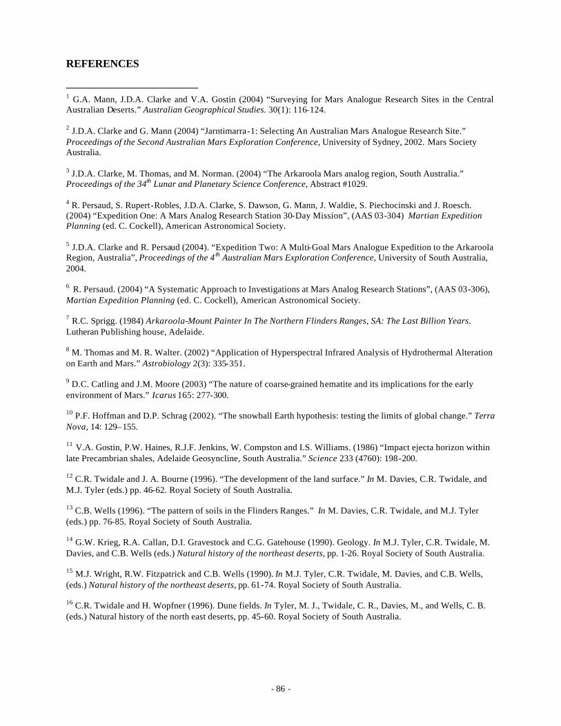
- 86 -
REFERENCES
1 G.A. Mann, J.D.A. Clarke and V.A. Gostin (2004) “Surveying for Mars Analogue Research Sites in the Central Australian Deserts.” Australian Geographical Studies. 30(1): 116-124.
2 J.D.A. Clarke and G. Mann (2004) “Jarntimarra-1: Selecting An Australian Mars Analogue Research Site.” Proceedings of the Second Australian Mars Exploration Conference, University of Sydney, 2002. Mars Society Australia. 3 J.D.A. Clarke, M. Thomas, and M. Norman. (2004) “The Arkaroola Mars analog region, South Australia.” Proceedings of the 34th Lunar and Planetary Science Conference, Abstract #1029. 4 R. Persaud, S. Rupert-Robles, J.D.A. Clarke, S. Dawson, G. Mann, J. Waldie, S. Piechocinski and J. Roesch. (2004) “Expedition One: A Mars Analog Research Station 30-Day Mission”, (AAS 03-304) Martian Expedition Planning (ed. C. Cockell), American Astronomical Society. 5 J.D.A. Clarke and R. Persaud (2004). “Expedition Two: A Multi-Goal Mars Analogue Expedition to the Arkaroola Region, Australia”, Proceedings of the 4 th Australian Mars Exploration Conference, University of South Australia, 2004. 6 R. Persaud. (2004) “A Systematic Approach to Investigations at Mars Analog Research Stations”, (AAS 03-306), Martian Expedition Planning (ed. C. Cockell), American Astronomical Society. 7 R.C. Sprigg. (1984) Arkaroola-Mount Painter In The Northern Flinders Ranges, SA: The Last Billion Years. Lutheran Publishing house, Adelaide. 8 M. Thomas and M. R. Walter. (2002) “Application of Hyperspectral Infrared Analysis of Hydrothermal Alteration on Earth and Mars.” Astrobiology 2(3): 335-351. 9 D.C. Catling and J.M. Moore (2003) “The nature of coarse-grained hematite and its implications for the early environment of Mars.” Icarus 165: 277-300. 10 P.F. Hoffman and D.P. Schrag (2002). “The snowball Earth hypothesis: testing the limits of global change.” Terra Nova, 14: 129–155. 11 V.A. Gostin, P.W. Haines, R.J.F. Jenkins, W. Compston and I.S. Williams. (1986) “Impact ejecta horizon within late Precambrian shales, Adelaide Geosyncline, South Australia.” Science 233 (4760): 198-200. 12 C.R. Twidale and J. A. Bourne (1996). “The development of the land surface.” In M. Davies, C.R. Twidale, and M.J. Tyler (eds.) pp. 46-62. Royal Society of South Australia. 13 C.B. Wells (1996). “The pattern of soils in the Flinders Ranges.” In M. Davies, C.R. Twidale, and M.J. Tyler (eds.) pp. 76-85. Royal Society of South Australia. 14 G.W. Krieg, R.A. Callan, D.I. Gravestock and C.G. Gatehouse (1990). Geology. In M.J. Tyler, C.R. Twidale, M. Davies, and C.B. Wells (eds.) Natural history of the northeast deserts, pp. 1-26. Royal Society of South Australia. 15 M.J. Wright, R.W. Fitzpatrick and C.B. Wells (1990). In M.J. Tyler, C.R. Twidale, M. Davies, and C.B. Wells, (eds.) Natural history of the northeast deserts, pp. 61-74. Royal Society of South Australia. 16 C.R. Twidale and H. Wopfner (1996). Dune fields. In Tyler, M. J., Twidale, C. R., Davies, M., and Wells, C. B. (eds.) Natural history of the north east deserts, pp. 45-60. Royal Society of South Australia.
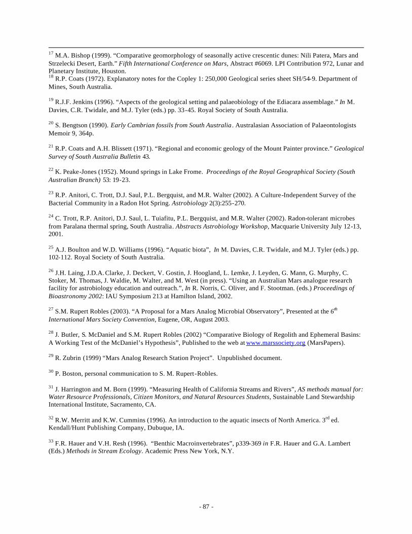
- 87 -
17 M.A. Bishop (1999). “Comparative geomorphology of seasonally active crescentic dunes: Nili Patera, Mars and Strzelecki Desert, Earth.” Fifth International Conference on Mars, Abstract #6069. LPI Contribution 972, Lunar and Planetary Institute, Houston. 18 R.P. Coats (1972). Explanatory notes for the Copley 1: 250,000 Geological series sheet SH/54-9. Department of Mines, South Australia. 19 R.J.F. Jenkins (1996). “Aspects of the geological setting and palaeobiology of the Ediacara assemblage.” In M. Davies, C.R. Twidale, and M.J. Tyler (eds.) pp. 33-45. Royal Society of South Australia. 20 S. Bengtson (1990). Early Cambrian fossils from South Australia . Australasian Association of Palaeontologists Memoir 9, 364p. 21 R.P. Coats and A.H. Blissett (1971). “Regional and economic geology of the Mount Painter province.” Geological Survey of South Australia Bulletin 43. 22 K. Peake-Jones (1952). Mound springs in Lake Frome. Proceedings of the Royal Geographical Society (South Australian Branch) 53: 19-23. 23 R.P. Anitori, C. Trott, D.J. Saul, P.L. Bergquist, and M.R. Walter (2002). A Culture-Independent Survey of the Bacterial Community in a Radon Hot Spring. Astrobiology 2(3):255-270. 24 C. Trott, R.P. Anitori, D.J. Saul, L. Tuiafitu, P.L. Bergquist, and M.R. Walter (2002). Radon-tolerant microbes from Paralana thermal spring, South Australia . Abstracts Astrobiology Workshop, Macquarie University July 12-13, 2001. 25 A.J. Boulton and W.D. Williams (1996). “Aquatic biota”, In M. Davies, C.R. Twidale, and M.J. Tyler (eds.) pp. 102-112. Royal Society of South Australia. 26 J.H. Laing, J.D.A. Clarke, J. Deckert, V. Gostin, J. Hoogland, L. Lemke, J. Leyden, G. Mann, G. Murphy, C. Stoker, M. Thomas, J. Waldie, M. Walter, and M. West (in press). “Using an Australian Mars analogue research facility for astrobiology education and outreach.”, In R. Norris, C. Oliver, and F. Stootman. (eds.) Proceedings of Bioastronomy 2002: IAU Symposium 213 at Hamilton Island, 2002. 27 S.M. Rupert Robles (2003). “A Proposal for a Mars Analog Microbial Observatory”, Presented at the 6th International Mars Society Convention, Eugene, OR, August 2003. 28 J. Butler, S. McDaniel and S.M. Rupert Robles (2002) “Comparative Biology of Regolith and Ephemeral Basins: A Working Test of the McDaniel’s Hypothesis”, Published to the web at www.marssociety.org (MarsPapers). 29 R. Zubrin (1999) “Mars Analog Research Station Project”. Unpublished document. 30 P. Boston, personal communication to S. M. Rupert-Robles. 31 J. Harrington and M. Born (1999). “Measuring Health of California Streams and Rivers”, AS methods manual for: Water Resource Professionals, Citizen Monitors, and Natural Resources Students, Sustainable Land Stewardship International Institute, Sacramento, CA. 32 R.W. Merritt and K.W. Cummins (1996). An introduction to the aquatic insects of North America. 3rd ed. Kendall/Hunt Publishing Company, Dubuque, IA. 33 F.R. Hauer and V.H. Resh (1996). “Benthic Macroinvertebrates”, p339-369 in F.R. Hauer and G.A. Lambert (Eds.) Methods in Stream Ecology. Academic Press New York, N.Y.

- 88 -
34 J.L. Plafkin, M.T. Barbour, K.D. Porter, S.K. Gross, and R.M. Hughes (1989). Rapid Bioassessment Protocols for Use in Streams and Rivers: Benthic Macroinvertebrates and Fish. EPA 444/4-89-001. U.S. Environmental Protection Agency, Washington, D.C. 35 V.H. Resh, M.J. Myers, and M.J. Hannaford (1996). “Macroinvertebrates as Biotic Indicators of Environmental Quality”, p647-667 in F.R. Hauer and G.A. Lambert (Eds.) Methods in Stream Ecology. Academic Press New York, N.Y. 36 L.J. Rothschild and R.L. Mancinelli (2001). “Life in extreme environments”, Nature 409: 1092-1101 (22 Feb 2001). 37 P. Mazur et al. (1978), Space Sci. Rev. 22: 3.
38 D.S. McKay, et al., Search for past life on Mars: possible relic biogenic activity in Martian meteorite ALH84001, Science 273 (5277): 924-930 (16 Aug 1996).
39 R. Navarro-Gonzalez, et al., Mars-like soils in the Atacama desert, Chile, and the dry limit of microbial life, Science 302: 1018-1021 (7 Nov 2003).
40 D. Warmflash et al. (2003). Detection of biomarkers of viable life in using immunoassay, Instruments, Methods, and Missions for Astrobiology V, Proceedings of SPIE Vol. 4859: 72-77. 41 K.H. Seo, R.E. Brackett, J.F. Frank, and S. Hilliard (1998). Immunomagnetic separation and flow cytometry for rapid detection of Escherichia coli O157:H7J Food Prot. 61(7):812-6. 42 J.A. Jones (2002), ‘Technologies for Microbial Detection on Mars,’ Environmental Sentinels Workshop 2002: Envisioning the Future of Monitoring Technologies for the Space, Terrestrial, and Defense Environments, Regent Park Conference Center, Houston, TX September, 2002. 43 K.D. Kourentzi, G.E. Fox, and R.C.Willson (2001), Microbial detection with low molecular weight RNA, Curr Microbiol . 43(6):444-7. 44 D. Harmsen and H. Karch (2004), 16S rRNA for Diagnosing Pathogens: a Living Tree, ASM News . 70(1): 19-24. 45 R.I. Aman et al. (1995), Phylogenetic identification and in-situ detection of individual microbial cell without cultivation. Microbiol. Rev. 59: 143-169. 46 M. Larios-Sanz et al (2002), Molecular Tools to monitor microbial contaminants during long-term exploration class mission, World Space Congress, poster presentation, Oct 2002, Houston. 47 M. Larios-Sanz (2003), Aspects of microbial monitoring using the ribosomal RNAs and molecular tools, PhD dissertation, University of Houston. 48 S. Tyagi and K.R. Kramer (1996), Molecular beacons: probes that fluoresce upon hybridization, Nat. Biotechnol. 14: 303-308. 49 S. Tyagi et al (1998), Multicolor molecular beacons for allele discrimination, Nat. Biotechnol. 16: 49-53. 50 Vet et al, Multiplex detection of four pathogenic retroviruses using molecular beacons. Proc. Natl. Acad. Sci. USA. 96: 6394-6399. 51 K.D. Kourentzi, G.E. Fox and R.C. Willson (2002), Microbial identification by immunohybridization assay of artificial RNA labels, J. Microbiol. Methods 49(3):301-6.
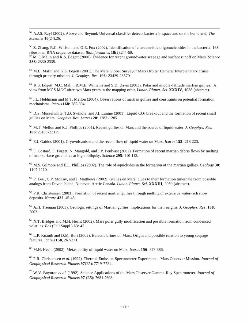
- 89 -
52 A.J.S. Rayl (2002), Above and Beyond: Universal classifier detects bacteria in space and on the homeland, The Scientist 16(24):26. 53 Z. Zhang, R.C. Willson, and G.E. Fox (2002), Identification of characteristic oligonucleotides in the bacterial 16S ribosomal RNA sequence dataset, Bioinformatics 18(2):244-50. 54 M.C. Malin and K.S. Edgett (2000). Evidence for recent groundwater seepage and surface runoff on Mars. Science 288: 2330-2335. 55 M.C. Malin and K.S. Edgett (2001). The Mars Global Surveyor Mars Orbiter Camera: Interplanetary cruise through primary mission. J. Geophys. Res. 106: 23429-23570. 56 K.S. Edgett, M.C. Malin, R.M.E. Williams and S.D. Davis (2003). Polar and middle -latitude martian gullies: A view from MGS MOC after two Mars years in the mapping orbit, Lunar. Planet. Sci. XXXIV, 1038 (abstract). 57 J.L. Heldmann and M.T. Mellon (2004). Observations of martian gullies and constraints on potential formation mechanisms. Icarus 168: 285-304. 58 D.S. Musselwhite, T.D. Swindle, and J.I. Lunine (2001). Liquid CO2 breakout and the formation of recent small gullies on Mars. Geophys. Res. Letters 28: 1283-1285. 59 M.T. Mellon and R.J. Phillips (2001). Recent gullies on Mars and the source of liquid water. J. Geophys. Res. 106: 23165-23179. 60 E.J. Gaidos (2001). Cryovolcanism and the recent flow of liquid water on Mars. Icarus 153: 218-223. 61 F. Costard, F. Forget, N. Mangold, and J.P. Peulvast (2002). Formation of recent martian debris flows by melting of near-surface ground ice at high obliquity. Science 295: 110-113. 62 M.S. Gilmore and E.L. Phillips (2002). The role of aquicludes in the formation of the martian gullies. Geology 30: 1107-1110. 63 P. Lee., C.P. McKay, and J. Matthews (2002). Gullies on Mars: clues to their formation timescale from possible analogs from Devon Island, Nunavut, Arctic Canada. Lunar. Planet. Sci. XXXIII, 2050 (abstract). 64 P.R. Christensen (2003). Formation of recent martian gullies through melting of extensive water-rich snow deposits. Nature 422: 45-48. 65 A.H. Treiman (2003). Geologic settings of Martian gullies; implications for their origins. J. Geophys. Res . 108: 2003. 66 N.T. Bridges and M.H. Hecht (2002). Mars polar gully modification and possible formation from condensed volatiles. Eos (Fall Suppl.) 83: 47. 67 L.P. Knauth and D.M. Burt (2002). Eutectic brines on Mars: Origin and possible relation to young seepage features. Icarus 158, 267-271. 68 M.H. Hecht (2002). Metastability of liquid water on Mars. Icarus 156: 373-386. 69 P.R. Christensen et al. (1992), Thermal Emission Spectrometer Experiment – Mars Observer Mission. Journal of Geophysical Research-Planets 97(E5): 7719-7734. 70 W.V. Boynton et al. (1992). Science Applications of the Mars Observer Gamma-Ray Spectrometer. Journal of Geophysical Research-Planets 97 (E5): 7681-7698.

- 90 -
71 S. Murchie et al. (2003) CRISM: Compact Reconnaissance Imaging Spectrometer for Mars on the Mars Reconnaissance Orbiter, in Sixth International Conference on Mars, Abstract #3062, LPI, Houston, TX. 72 G.R. Hunt (1979) Near infrared (1.3-2.4 µm) spectra of alteration minerals - potential for use in remote sensing. Geophysics 44: 1974-1986. 73 D.L. Huston (1998) Gamma ray spectrometric and oxygen-isotope mapping of regional alteration halos in massive sulphide districts: an examp le from Panorama, central Pilbara Craton. AGSO Research Newsletter 29: 14. 74 A.J.B. Thompson, P.L. Hauff, and A.J. Robitaille (1999). Alteration mapping in exploration: application of short-wave infrared (SWIR) spectroscopy. SEG Newsletter 39: 16-27. 75 M. Thomas and M.R. Walter (2002). Application of Hyperspectral Infrared Analysis of Hydrothermal Alteration on Earth and Mars. Astrobiology, 2 (3), 335-351. 76 R.P. Coats and A.H. Blissett (1971). Regional and economic geology of the Mount Painter province, in South Australia Geological Survey Bulletin 43: 426, Adelaide, SA. 77 J.F. Drexel (1980). Geology of a portion of the southern Mount Painter Inlier, in Report Book Number 80/102, pp. 62, Department of Mines and Energy, Mineral Resources Section, Adelaide, SA. 78 J.B. Jago and P.S. Moore, (1990) The Evolution of a Late Precambrian-Early Palaeozoic Rift Complex: The Adelaide Geosyncline, in Geological Society of Australia Special Publication 16. 79 J.F. Drexel, W.V. Preiss, and A.J. Parker (1993) The Geology of South Australia. Vol. 1, The Precambrian, in South Australia Geological Survey Bulletin 54, Department of Mines and Energy, Mineral Resources Section, Adelaide, SA. 80 W.V. Preiss (2000) The Adelaide Geosyncline of South Australia and its significance in Neoproterozoic continental reconstruction. Precambrian Research 100 (1-3): 21-63. 81 W.V. Preiss (1973) Palaeoecological interpretations of South Australian Precambrian stromatolites. Journal of the Geological Society of Australia 19: 501-532. 82 J.D.A. Clarke, J. Deckert, V. Gostin, J. Hoogland, J. Laing, L. Lemke, J. Leyden, G. Mann, G. Murphy, C. Stoker, M. Thomas, J. Waldie, M. Walter and M. West (2002). “Selecting Australian Mars analogue sites: methodology and criteria”. Abstracts 16th AGC, Adelaide. 83 J.D.A. Clarke, and G.A. Mann (2002). “Jarntimarra 1: Selecting an Australian Mars Analogue Research Site”. In J.D.A. Clarke, G. Murphy and M. West (eds.). From the red center to the red planet. Proceedings of the 2nd Australian Mars Exploration Conference, Faculty of Engineering, University of Sydney, New South Wales, Australia. Mars Society Australia, ISSN: 1448-2185. 84 G.A. Mann, J.D.A. Clarke, and V.A. Gostin (2004). “Surveying for Mars Analogue Research Sites in the Central Australian Deserts”. Australian Geographical Studies. In press. 85 Kanas, N., Salnitskiy, V., Grund, E.M., Weiss, D.S., Gushin, V., Bostrom, A., Kozerenko, O., Sled, A. & Marmar, C.R. (2001). Psychosocial Issues in Space: Results from Shuttle/Mir. Gravitational and Space Biology Bulletin; 14(2), 35-46. 86 Gushin, V.I., Efimov, V.A., Kolinitchenko, T.B., and Davies, C. (1996) Psychological evaluation and support during EXEMSI. In S. Bonting (Ed.), Advances in Space Biology and Medicine, European Isolation and Confinement Study, (Vol. 5, 283-295). 87 Dawson, S. (2002). Human Factors in Mars Research: An Overview. Proceedings of the Second Australian Mars Exploration Conference. University of Sydney, July 2002. Mars Society Australia.
- 91 -
88 ISU, (1991). International Mars mission final report. International Space University, Tolouse, France. 89 Burrough, B. (1998). Dragonfly: An Epic Adventure of Survival in Outer Space. HarperCollins, New York. 90 Haythorn, W.W. (1970). Interpersonal stress in isolated groups. In: Social and Psychological Factors in Stress. McGrath, J.E., ed.) New York: Holt Rinehart & Winston, pp. 159-176. 91 Palinkas, L.A. (1990). Psychosocial effects of adjustment in Antarctica: lessons for long-duration spaceflight. Journal of Spacecraft and Rockets 27:471-477. 92 Stuster, J., Bachelard, C. and Suedfeld, P. (2000). The relative importance of behavioral issues during longduration ICE missions. Aviation, Space, and Environmental Medicine 71(9, Suppl.): A17-25. 93 Nicholas, J.M. and Penwell, L.W. 1995. A proposed profile of the effective leader in human spaceflight based on findings from analogue environments. Aviation, Space, and Environmental Medicine 66:63-72. 94 Palinkas, L.A., (2001). Psychosocial Issues Long-Term Space Flight: Overview. Gravitational and Space Biology Bulletin ; 14(2), 25-34. 95 Gushin, V.I., Zaprisa N., Kolinitchenko T.B., Efimov, V.A., Smirnova, T.M., and Vinokhodova, A.G. (1997) The dynamics of communicative interaction of crew with external parties during long-term isolation. Aerospace and Ecological Medicine, 4, 15-20. 96 Sandal, G.M., (2001). Psychosocial Issues in Space: Future Challenges. Gravitational and Space Biology Bulletin ; 14(2), 47-54. 97 Tajfel, H. & Turner, J. C. (1979). An integrative theory of intergroup conflict. In W. G. Austin & S. Worchel (Eds.) The social psychology of intergroup relations (pp. 33-47). Monterey, CA: Brooks/Cole. 98 Turner, J. C., Hogg, M. A., Oakes, P. J., Reicher, S. D., & Wetherell, M. S. (1987). Rediscovering the social group: A self-categorization theory. Oxford, UK: Blackwell. 99 Turner, J. C. (1991). Social influence. Buckingham, UK: Open University Press. 100 Haslam, S. A. (2001). Psychology in organizations: The social identity approach. London and Thousand Oaks, CA: Sage. 101 Eggins, R. A., Haslam, S. A., & Reynolds, K. J. (2002). Social identity and negotiation: Subgroup representation and superordinate consensus. Personality and Social Psychology Bulletin , 28, 887-899. 102 Turner, J. C., Hogg, M. A., Oakes, P. J., Reicher, S. D., & Wetherell, M. S. (1987). Rediscovering the social group: A self-categorization theory. Oxford, UK: Blackwell. 103 Tajfel, H. (1972). La catégorisation sociale (Social categorization). In S. Moscovici (Ed.) Introduction à la psychologie sociale (pp. 272-302). Paris: Larouse. 104 Tajfel. H. (1978). Interindividual behaviour and intergroup behaviour. In H. Tajfel (Ed.), Differentiation between social groups: Studies in the social psychology of intergroup relations. London: Academic Press. 105 Tajfel, H., Flament, C., Billig, M. G., & Bundy, R. F. (1971) Social categorization and intergroup behaviour. European Journal of Social Psychology, 1, 149-177. 106 Ellemers, N., Spears, R., & Doosje, B. (1999). Social identity: Context, content and commitment. Oxford: Blackwell.
- 92 -
107 Oakes, P. J., Haslam, S. A., & Turner, J. C. (1994). Stereotyping and social reality. Oxford, UK: Blackwell. 108 Turner, J. C., Hogg, M. A., Oakes, P. J., Reicher, S. D., & Wetherell, M. S. (1987). Rediscovering the social group: A self-categorization theory. Oxford, UK: Blackwell. 109 Terry, D. J. & Callan, V. J. (1998). Ingroup bias in response to an organizational merger. Group Dynamics: Theory, Research and Practice, 2, 67-81. 110 Ouwerkerk, J. W., Ellemers, N., & de Gilder, D. (1999). Social identification, affective commitment and individual effort on behalf of the group. In N. Ellemers, R. Spears & B. J. Doosje (Eds). Social identity: Context, commitment, content (pp. 184-204). Oxford, UK: Blackwell. 111 Ellemers, N., de Gilder, D., & van den Heuvel, H. (1998). Career-oriented versus team-oriented commitment and behaviour at work. Journal of Applied Psychology, 83, 717-730. 112 Kelly, C. & Kelly, J. (1994). Who gets involved in collective action? Social psychological determinants of individual participation in trade unions. Human Relations, 47, 63-88. 113 Veenstra, K. & Haslam, S. A. (2000). Willingness to participate in industrial protest: Exploring social identification in context. British Journal of Social Psychology, 39, 153-172. 114 Kramer, R. M, Brewer, M. B., & Hanna, B. A. (1996). Collective trust and collective action: The decision to trust as a social decision. In R. M. Kramer & T. R. Tyler (Eds.), Trust in organizations: Frontiers of theory and research (pp. 357-389). Thousand Oaks, CA: Sage. 115 Dovidio, J. F., Gaertner, S. L., Validzic, A., Matoka, K., Johnson, B., & Frazier, S. (1997). Extending the benefits of recategorization: Evaluations, self-disclosure, and helping. Journal of Experimental Social Psychology, 33, 401-420. 116 Postmes, T., Tanis, M. & de Wit, B. (2001). Communication and commitment in organizations: a social identity approach. Group Processes and Intergroup Relations, 4, 227-246. 117 Kramer, R. M. (1993). Cooperation and organizational identification. In J. K. Murnigham (Ed.), Social psychology in organizations: Advances in theory and research (pp. 244-268). Engelwood Cliffs, NJ: Prentice Hall. 118 Tyler, T. R. & Blader, S. (2000). Co-operation in groups: Procedural justice, social identity and behavioral engagement. Philadelphia, PA: Psychology Press. 119 James, K. & Greenberg, J. (1989). Ingroup salience, intergroup comparison and individual performance and self-esteem. Personality and Social Psychology Bulletin, 15, 604-616. 120 Worchel, S., Rothgerber, H., Day, A., Hart, D. & Butemeyer, J. (1998). Social identity and individual productivity within groups. British Journal of Social Psychology, 37, 389-413. 121 Johnson, S. (2002) Management by stress: The influence of social identification in empowered teams on occupational stress and performance. Unpublished Clinical Master thesis Australian National University. 122 Reicher, S., & Haslam, S.A. (2002). Powerless groups and the emergence of tyranny: The BBC Prison Experiment. Unpublished Manuscript, University of St Andrews, UK. 123 Terry, D.J., & Jimmieson, N.L. (1999) Work control and employee well being: A decade review. In C.L. Cooper and I.T. Robertson (Ed) Review of Industrial and Organizational Psychology (vol. 14). Chichester, UK : John Wiley & Sons Ltd.

- 93 -
124 Polzer, J., Swamm,W. B., & Milton, L. P. (in press). The benefits of verifying diverse identities for group performance, In J. Polzer (Ed) Research on Managing Groups and Teams (Vol 5). 125 Stone, A.A. (1995) Measurement of affective responses. In S. Cohen, R.S. Kessler & L. U. Gordon (Eds.) Measuring stress: A guide for health and social scientists (pp. 148-171). New York: Oxford University Press. 126 Burns, J. M. (1978). Leadership. New York: Harper & Row. 127 House, R. J., Spangler, W. D. & Woycke, J. (1991). Personality and charisma in the U.S. presidency: A psychological theory of leader effectiveness. Administrative Science Quarterly, 36, 364-396. 128 Carver, C.S. and Scheier, M.F. 1994. Situational coping and coping dispositions in a stressful transaction. Journal of Personality and Social Psychology 66:184-195. 129 Nicholas, J.M. and Penwell, L.W. 1995. A proposed profile of the effective leader in human spaceflight based on findings from analogue environments. Aviation, Space, and Environmental Medicine 66:63-72. 130 Haslam, S. A., & Platow, M. J. (2001). The link between leadership and followership: How affirming a social identity translates vision into action. Personality and Social Psychology Bulletin, 27, 1469-1479. 131 Haslam, S. A. Eggins, R. A., & Reynolds, K. J. (2003). The ASPIRe model: Actualizing Social and Personal Identity Resources to enhance organizational outcomes. Journal of Occupational and Organizational Psychology, 76, 83-113. 132 Committee on Space Biology and Medicine.1998. A Strategy for Research in Space Biology and Medicine in the Next Century. Washington, DC: National Academy Press. 133 Fowler, B., Comfort, D., & Bock, O. (2000). A review of cognitive and perceptual-motor performance in space. Aviat Space Environ Med; 71:A66-8; Section II. 134 Manzey, D. (2000). Monitoring of Mental Performance During Spaceflight. Aviat Space Environ Med; 71:A69-75; Section II. 135 Palinkas, L. A., Gunderson, E. K., Johnson, J C., Holland, A. W. (2000). Behavior and Performance on Long-Duration Spaceflights: Evidence from Analogue Environments. Aviat Space Environ Med; 71:A29-36; Section II 136 Gushin, V.I. & Avgustovitch, E.V. (1993) " JOY-test : Dynamic Changes of Work Capability under Isolation", Proceedings of the Symposium on Human Behaviour in space simulation studies, I -- 2 December, Paris. - ESA, Directorate of Space Station and Microgravity. 137 Retzlaff, P. D., Vanderploeg, R. D., Flynn, C., McGarraugh, M., & Devine, S. (2000, August). Space flight cognitive assessment tool: Validity against traditional measures. Paper presented at the Annual Meeting of the American Psychological Association, Washington, DC. (Abstract). The Clinical Neuropsychologist, 14, 257 138 Flynn, C., Eksuzian, D., Vander Ark, S., Sipes, W., (2002) Spaceflight Cognitive Assessment Tool for the Lunar-Mars Life Support Test Project Phase III Test in Lane, H.W., Sauer, R.L., Feeback D.L., (Eds.) Isolation. NASA Experiments in Closed-Environment Living. Univelt Inc. 139 Collie A, Myers C, Schnirman D, Wood S & Maruff P (2002). An investigation of impairment in associate learning in mild cognitive impairment. Journal of Cognitive Neuroscience 14:484-492. 140 Darby D, Maruff P, Collie A, McStephen (2002) Repeated administration of a cognitive test battery in mild cognitive impairment. Neurology 59, 1042-1046.

- 94 -
141 Collie A, Maruff P, Darby D (2003). The effects of practice on the cognitive test performance of neurologically normal individuals assessed at brief test-retest intervals. Journal of the International Neuropsychological Society. 9(3): 419-28. 142 Maruff P, Faletti M, Collie A, Darby D, McStephen M (in press). Fatigue related impairment in the speed accuracy and consistency of cognitive performance. Journal of Sleep Research (accepted 12/2002). 143 Maruff, P Collie A Darby D (in press). Attentional and memory impairment in Mild Cognitive Impairment (MCI). Developmental Neuropsychology (accepted 3/2002) 144 Purcell R, Maruff P, Kyrios M, Pantelis C. (1997). Neuropsychological function in young patients with unipolar major depression. Psychol Med 27:1277–1285. 145 Dawson, S. (2003). Expedition One Psychology Report. Mars Society Field Report http://www.marssociety.org/MDRS/fs02/crew14/psycho.asp 146 S.T. Sklar and S.M. Rupert-Robles (2004), "A Field Methodology Approachbetween Anearth-Based Remote Science Team And A Planetary-Based Field Crew", Proceedings of the 7th International Mars Society Convention (in press). 147 R.A. Eggleton and G. Taylor (2001) Regolith geology and geomorphology. John Wiley & Sons. 148 C.D. Ollier and C. Pain (1996). Regolith, soils, and landforms. John Wiley & Sons. 149 R.A. Eggleton (2002). The regolith glossary. CRC LEME, Floreat Park, Perth, Australia. 150 J.D.A. Clarke and C.F. Pain (2004). From Utah to Mars: regolith-landform mapping and its application. In C.C. Cockell, (ed.). Mars Expedition Planning . American Astronautical Society Science and Technology Series, 107: 131-160. 151 C.F. Pain, R. Chan, M. Craig, D. Gibson, P. Ursem and J. Wilford (2004). RTMAP regolith database field book and users guide. CRC LEME Report 138, 2nd Edition 152 J. Waldie, D. Wisely, D. Ischia, B. Harvey, “MarsSkin: A Mechanical Counter Pressure Mars Analogue Space Suit”, Proceedings of the 2nd Australian Mars Exploration Conference (AMEC2002) , University of Sydney, Australia, July 2002.