Embed Size (px)
Citation preview
1
EXECUTIVE SUMMARY REPORT OF CEIA STUDY FOR BANSUJARA IRRIGATION PROJECT
1. GENERAL
The Water Resources Department, state government of Madhya Pradesh proposes to
develop Bansujara Irrigation project. The Bansujara Dam Project site is located at
latitude 240-37'-32.87" N and longitude 790-08'-22.91” E on Dhasan river near village Ban
in Bada malhera tehsil of Chhatarpur district and village Sujara in Tikamgarh tehsil of
Tikamgarh district of Madhya Pradesh.
The GCA and CCA of the project are 58468 ha and 49373 ha respectively. The project
shall irrigate an area of 17,000 ha in Rabi and 37,000 ha in kharif seasons. The project
location map is enclosed as Figure-1.
2. PROJECT DESCRIPTION
The project comprises of the following main components: -
• Construction of a 1158.2 m long homogenous earth dam with concrete gated
spillway of height 21.33 m.
• Water spread at FRL shall be 5201.71 ha with a gross storage capacity of 313.10
Mm3.
• Construction of left bank canal of 90 km in length with 22.35 km of
distributaries.
The index map of the project showing the dam and canal distribution system is enclosed
as Figure-2.
The tentative total land required for various project components is of about 5886.97 ha.
The details are given in Table-1. About 2935.11 ha of revenue/government land and
2894.37 ha of private land is to be acquired. In addition, about 57.49 ha of forest land
too is to be acquired.
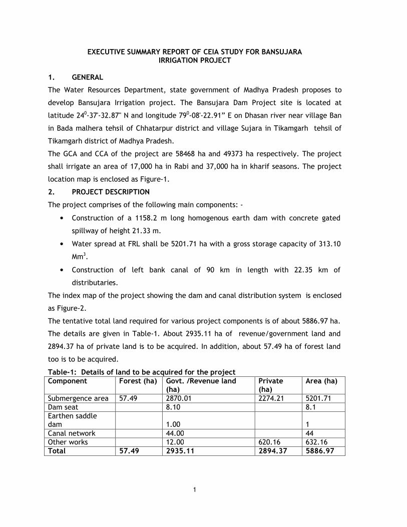
Table-1: Details of land to be acquired for the project Component Forest (ha) Govt. /Revenue land
(ha) Private (ha)
Area (ha)
Submergence area 57.49 2870.01 2274.21 5201.71
Dam seat 8.10 8.1
Earthen saddle dam 1.00 1
Canal network 44.00 44
Other works 12.00 620.16 632.16
Total 57.49 2935.11 2894.37 5886.97
2
3. STUDY AREA
The study area covered as a part of the EIA study is as below (Refer Figure-3).
• Submergence area
• Area to be acquired for various project appurtenances
• Area within 10 km of various project appurtenances including i.e. canal network, etc.
• Gross Command Area
• Catchment Area intercepted at the dam site
4. ENVIRONMENTAL BASELINE STATUS
The baseline status for the above referred categories has been described in the
following sections.
4.1 PHYSCIO-CHEMICAL ASPECTS
4.1.1 Meteorology
The project area of the proposed Bansujara Irrigation project experiences semi-arid
climate characterized by hot summer, pleasant cold winter and general dryness
throughout the years, except during monsoon season. The year may be divided into four
seasons. The summer season lasts from March to about middle of June, followed by the
south-west monsoon season from mid-June to the end of September. The months of
October and November constitute the post-monsoon or transition period. The winter
season is observed from December to February.
4.1.2 Soils
The pH in various soil samples ranged from 6.4 to 7.2. The Electrical Conductivity (EC)
ranged from 125 to 380 µS/cm. The concentration of available nitrogen, available
potassium and available phosphorus ranged from 199 to 324 kg/ha, 181 to 528 kg/ha and
8.64 to 47.67 kg/ha respectively. The organic carbon ranged from 0.5 to 0.99%,
indicating medium to high productivity.
4.1.3 Surface Water Quality
The pH level in various seasons ranged from 7.6 to 7.9 indicating neutral nature of
water. The TDS level ranged from 189 to 212 mg/l, 172 to 188 mg/l and 187 to 198 mg/l
in pre-monsoon, monsoon and winter seasons respectively. The TDS levels were well
below the permissible limit of 500 mg/l specified for meeting drinking water
requirements. The EC levels were well below the permissible limit of 2250 µS/cm
specified for irrigation water requirements as per IS:2296.
3
The concentration of chlorides in various seasons ranged from 21.5 to 31.4 mg/l. The
chlorides level in surface water samples was well below the permissible limit of 200
mg/l. The sulphates level in various seasons ranged from 5.4 to 8.2 mg/l. The sulphates
level were well below the permissible limit of 200 mg/l.
The BOD values are well within the permissible limits, which indicates the absence of
organic pollution loading. The concentration of various heavy metals was observed to be
below detectable limit in various seasons.
4.1.4 Ground Water Quality
The pH level ranges from 7.5 to 7.9, 7.2 to 7.8 and 7.4 to 7.8 in pre-monsoon, monsoon
and winter seasons covered as a part of the study. The chlorides level ranged from 75 to
90 mg/l in pre-monsoon season, 65 to 76 mg/l in monsoon season and 74 to 84 mg/l in
winter season. The chlorides level in groundwater samples was well below the
permissible limit of 200 mg/l. The TDS levels were within the permissible limit of 500
mg/l in various seasons.
The BOD values are well within the permissible limits, which indicates the absence of
pollution sources. The concentration of various heavy metals were below the detectable
limits.
4.1.5 Ambient Air Quality
As a part of the field studies, various ambient air quality locations were monitored.
Based on the findings of the ambient air quality survey, conducted for various seasons, it
can be concluded that the ambient air quality is quite good in the area.
4.1.6 Noise Environment
The day time equivalent noise level at various sampling stations were observed to be
well within permissible limits specified for residential area.
4.1.7 Land use pattern
The land use pattern of the submergence and command areas is outlined in Tables 2 and
3 respectively.
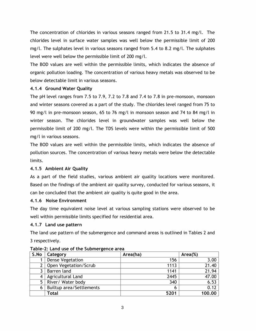
Table-2: Land use of the Submergence area
S.No Category Area(ha) Area(%) 1 Dense Vegetation 156 3.00
2 Open Vegetation/Scrub 1113 21.40
3 Barren land 1141 21.94
4 Agricultural Land 2445 47.00
5 River/ Water body 340 6.53
6 Builtup area/Settlements 6 0.12
Total 5201 100.00
4
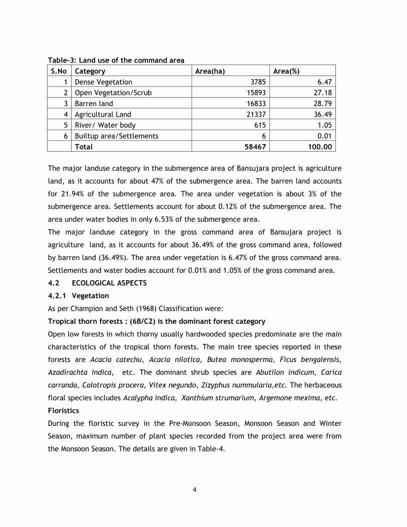
Table-3: Land use of the command area
S.No Category Area(ha) Area(%)
1 Dense Vegetation 3785 6.47
2 Open Vegetation/Scrub 15893 27.18
3 Barren land 16833 28.79
4 Agricultural Land 21337 36.49
5 River/ Water body 615 1.05
6 Builtup area/Settlements 6 0.01
Total 58467 100.00
The major landuse category in the submergence area of Bansujara project is agriculture
land, as it accounts for about 47% of the submergence area. The barren land accounts
for 21.94% of the submergence area. The area under vegetation is about 3% of the
submergence area. Settlements account for about 0.12% of the submergence area. The
area under water bodies in only 6.53% of the submergence area.
The major landuse category in the gross command area of Bansujara project is
agriculture land, as it accounts for about 36.49% of the gross command area, followed
by barren land (36.49%). The area under vegetation is 6.47% of the gross command area.
Settlements and water bodies account for 0.01% and 1.05% of the gross command area.
4.2 ECOLOGICAL ASPECTS
4.2.1 Vegetation
As per Champion and Seth (1968) Classification were:
Tropical thorn forests : (6B/C2) is the dominant forest category
Open low forests in which thorny usually hardwooded species predominate are the main
characteristics of the tropical thorn forests. The main tree species reported in these
forests are Acacia catechu, Acacia nilotica, Butea monosperma, Ficus bengalensis,
Azadirachta indica, etc. The dominant shrub species are Abutilon indicum, Carica
carranda, Calotropis procera, Vitex negundo, Zizyphus nummularia,etc. The herbaceous
floral species includes Acalypha indica, Xanthium strumarium, Argemone mexima, etc.
Floristics
During the floristic survey in the Pre-Monsoon Season, Monsoon Season and Winter
Season, maximum number of plant species recorded from the project area were from
the Monsoon Season. The details are given in Table-4.
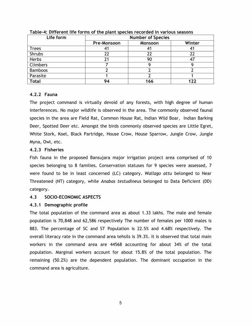
5
Table-4: Different life forms of the plant species recorded in various seasons Life form Number of Species
Pre-Monsoon Monsoon Winter Trees 41 41 41
Shrubs 22 22 22
Herbs 21 90 47
Climbers 7 9 9
Bamboos 2 2 2
Parasite 1 2 1
Total 94 166 122
4.2.2 Fauna
The project command is virtually devoid of any forests, with high degree of human
interferences. No major wildlife is observed in the area. The commonly observed faunal
species in the area are Field Rat, Common House Rat, Indian Wild Boar, Indian Barking
Deer, Spotted Deer etc. Amongst the birds commonly observed species are Little Egret,
White Stork, Koel, Black Partridge, House Crow, House Sparrow, Jungle Crow, Jungle
Myna, Owl, etc.
4.2.3 Fisheries
Fish fauna in the proposed Bansujara major irrigation project area comprised of 10
species belonging to 8 families. Conservation statuses for 9 species were assessed, 7
were found to be in least concerned (LC) category. Wallago attu belonged to Near
Threatened (NT) category, while Anabas testudineus belonged to Data Deficient (DD)
category.
4.3 SOCIO-ECONOMIC ASPECTS
4.3.1 Demographic profile
The total population of the command area as about 1.33 lakhs. The male and female
population is 70,848 and 62,586 respectively The number of females per 1000 males is
883. The percentage of SC and ST Population is 22.5% and 4.68% respectively. The
overall literacy rate in the command area tehsils is 39.3%. It is observed that total main
workers in the command area are 44568 accounting for about 34% of the total
population. Marginal workers account for about 15.8% of the total population. The
remaining (50.2%) are the dependent population. The dominant occupation in the
command area is agriculture.
6
4.3.2 Agriculture
The total cropped area in command area is 48157 ha. The major agriculture crops grown
in the command area are cereals, which account for about 44% of the total cropped
area. Oil seeds and Pulses are grown over 25.2% and 30.8% of the total cropped area.
5. PREDICTION OF IMPACTS
The impacts on various aspects of environment are briefly described in the following
sections.
5.1 IMPACTS ON LAND ENVIRONMENT
a) Construction Phase
Environmental degradation due to immigration of labour population
The peak labour and technical staff congregation would be of the order of 1,200 and 300
respectively. The total increase in population shall be of the order of 3,800. Separate
accommodation and related facilities for workers, service providers and technical staff
are to be provided as a part of the project. The congregation of labour force is likely to
create problems of sewage disposal, solid waste management and felling of trees for
meeting fuel requirements, etc.
Operation of construction equipment
During construction phase, various types of equipment will be brought to the site. These
include batching plant, earth movers, etc. The siting of these construction equipment
would require significant amount of space. In addition, land will be required for storage
of various construction material as well. However, land for this purpose will be
temporarily acquired, i.e. for the duration of project construction phase.
Efforts must be made for proper siting of these facilities. Various criteria for selection of
these sites would be:
• Proximity to the site of use
• Sensitivity of forests in the nearby areas
• Proximity from habitations
• Proximity to drinking water source
Soil erosion
The runoff from various construction sites, will have a natural tendency to flow towards
along with the natural drainage. Thus, the disposal of drainage effluent with such high
turbidity levels is bound to affect the water quality, especially in the lean season. The
drains/nallahs close to various construction sites along the canal alignment are seasonal
in nature. Normally in such rivers biological productivity is not high. Hence, the increase
in turbidity levels are not expected to be significant in nature.
7
b) Operation Phase
Acquisition of land
The tentative total land required for various project components is of about 5,886.11
ha. About 2935.11 ha of government land and 2894.37 ha of private land is to be
acquired. About 57.49 ha of forest land is to be acquired for the project. Based on the
ownership status of the land to be acquired, appropriate compensatory measures have
been formulated.
Change in land use pattern
The total cropped area in the command is 49500 ha. The major crops in Kharif season
are paddy (18.98%), sugarcane (0.19%), other Kharif (65.91%). In Rabi, wheat (29.11%)
and other Rabi (23.93%) are grown. In the project operation phase irrigation will be
provided over an area of 54000 ha. This would increase the agriculture production in the
command area and is a significant positive impact.
5.2 IMPACTS ON WATER RESOURCES AND QUALITY
a) Construction Phase
Impacts due to sewage generation from labour camps
The construction phase also leads to mushrooming of various allied activities to meet
the demands of the immigrant labour population in the project area. The increase in the
population is expected to be of the order of 3,800. The labour population is likely to be
congregated at three to four labour colonies.
The total domestic water requirements of the labour population (including families) is
expected to be of the order of 0.513 mld @ 135 lpcd. It is assumed that about 80% of the
water supplied will be generated as sewage. Thus, the total quantum of sewage
generated is expected to be of the order of 0.41 mld. The total BOD load contributed by
various labour camps/colonies will be about 171 kg/day. The above pollution loading is
likely to be spread over 3 to 4 labour camps. The disposal of sewage without treatment
could lead to adverse impacts on land environment or water environment in which the
effluent from the labour camps/colonies are disposed. Thus, the sewage will be treated
prior to disposal.
Impacts due to runoff from construction sites
Substantial quantities of water would be used in the construction activities. With
regards to water quality, waste water from construction activities would mostly contain
suspended impurities. Adequate care should be taken so that excess suspended solids in
the wastewater are removed before discharge into water body.
8
b) Operation Phase
Impacts on downstream users
The surface water and groundwater availability in the project area are 588.68 Mm3 and
58.86 Mm3. The total water availability works out to 647.51 Mm3. The total surface
water requirements upstream of Bansujara dam is of the area of 206 Mm3. The details
are given as below:
Upstream surface water requirements
• Irrigation requirement of constructed medium. Minor and : 206 Mm3 Proposed projects
• Domestic use : 10 Mm3
• Industrial use : 15 Mm3
• Environmental and Ecological requirements : 10 Mm3 Total : 241 Mm3
Upstream groundwater requirements
• For use on u/s of Bansujara dam in irrigation by : 40 Mm3 ground water
• For use on u/s of Bansujara dam for domestic use : 10 Mm3 ground water
• For use on u/s of Bansujara dam for industrial use : 5 Mm3 ground water Total : 55 Mm3
The net water available at dam site is (647.54 – 241.00 – 55.00) 351.54 Mm3. About
68.308 Mm3 of water will be available by regeneration from various sources including
irrigation, domestic and industrial use.
The storage capacity of Bansujara Reservoir is 539.42 Mm3. The downstream water
requirements are 15.18 Mm3, which includes water requirement for environmental and
ecological balance, drinking water including reservoir & supply losses (9 Mm3) and
industrial use (54 Mm3). Considering irrigation water requirements as 272.7 Mm3, the
water available for miscellaneous use shall be only 57.05 Mm3
Impacts on waterlogging and soil salinity
The total water requirement during Kharif and Rabi seasons is 242.7 Mm3 over an
irrigated command of 54,000 ha. This works out to an average water depth of 449 mm.
The area irrigated under ponded and pressure irrigation is 48,600 and 5,400 ha
respectively. The irrigated water not being utilized in ponded irrigation is (0.46*48,600
ha*0.449m) 100.38 Mm3. The irrigated water not being utilized in pressure irrigation is
(0.20*4,860 ha*0.443m) 4.90 Mm3. The total irrigation water being wasted is 105.28
Mm3. For an irrigated command of 54,000 ha, the average depth of water being wasted
9
works out to an average water depth of 195 mm. The quantum of water not being
utilized is quite small and is not expected to cause any significant problem of
waterlogging.
Changes in water quality due to increased use of fertilizers
With the introduction of irrigation, use of fertilizers is likely to increase, to maintain the
increased levels of production. The drainage system (natural or man-made) is likely to
contain much higher level of nutrients. The climatic conditions in the project area too is
suitable for the proliferation of eutrophication in the project area. Thus, in the project
operation phase, there will be increased probability of eutrophication in the water
bodies receiving agricultural runoff. As a part of Environmental Management Plan,
appropriate control measures have been recommended.
Impacts due to effluent from project colony
It is proposed to provide biological treatment facilities including secondary treatment
units for sewage so generated from the project colony. This will ensure that there are
no adverse impacts due to disposal of effluents from the labour colony.
5.3 IMPACTS ON TERRESTRIAL ECOLOGY
a) Construction Phase
Flora
Workers and other population groups residing in the area may use fuel wood (if no
alternate fuel is provided) for whom firewood/coal depot could be provided. In absence
of alternative source of fuel, the labour population would resort to cutting of trees and
vegetation in areas close to various construction sites. Hence, to minimize such impacts,
it shall be mandatory for the contractor to provide fuel to labour population.
Fauna
During construction phase, a large number of machinery and construction labour will
have to be mobilized. This activity may create some disturbance to the wildlife
population. The forest area shall not be covered for irrigation. The area which is to be
irrigated, and comprises mainly of agriculture land interspersed with settlement. As a
result of absence of forest or vegetal cover in the command area and increased level of
human interferences in the area, wildlife is generally absent in the area.
10
b) Operation Phase
Impacts on vegetal cover
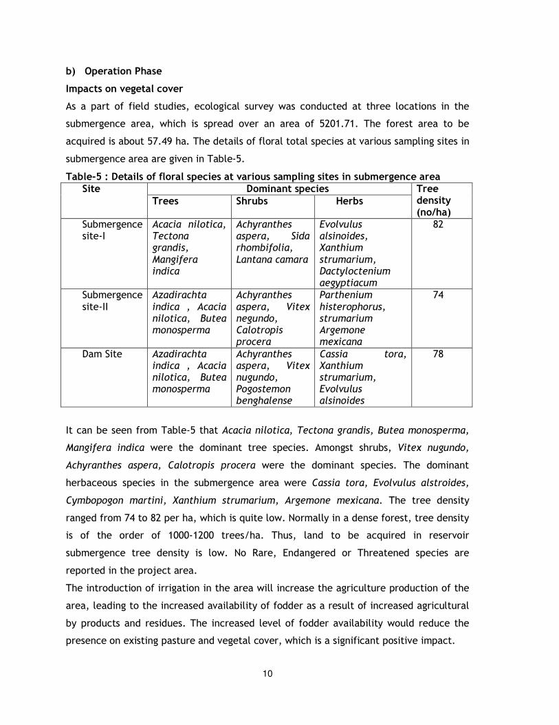
As a part of field studies, ecological survey was conducted at three locations in the
submergence area, which is spread over an area of 5201.71. The forest area to be
acquired is about 57.49 ha. The details of floral total species at various sampling sites in
submergence area are given in Table-5.
Table-5 : Details of floral species at various sampling sites in submergence area Site Dominant species Tree
density (no/ha)
Trees Shrubs Herbs
Submergence site-I
Acacia nilotica, Tectona grandis, Mangifera indica
Achyranthes aspera, Sida rhombifolia, Lantana camara
Evolvulus alsinoides, Xanthium strumarium, Dactyloctenium aegyptiacum
82
Submergence site-II
Azadirachta indica , Acacia nilotica, Butea monosperma
Achyranthes aspera, Vitex negundo, Calotropis procera
Parthenium histerophorus, strumarium Argemone mexicana
74
Dam Site Azadirachta indica , Acacia nilotica, Butea monosperma
Achyranthes aspera, Vitex nugundo, Pogostemon benghalense
Cassia tora, Xanthium strumarium, Evolvulus alsinoides
78
It can be seen from Table-5 that Acacia nilotica, Tectona grandis, Butea monosperma,
Mangifera indica were the dominant tree species. Amongst shrubs, Vitex nugundo,
Achyranthes aspera, Calotropis procera were the dominant species. The dominant
herbaceous species in the submergence area were Cassia tora, Evolvulus alstroides,
Cymbopogon martini, Xanthium strumarium, Argemone mexicana. The tree density
ranged from 74 to 82 per ha, which is quite low. Normally in a dense forest, tree density
is of the order of 1000-1200 trees/ha. Thus, land to be acquired in reservoir
submergence tree density is low. No Rare, Endangered or Threatened species are
reported in the project area.
The introduction of irrigation in the area will increase the agriculture production of the
area, leading to the increased availability of fodder as a result of increased agricultural
by products and residues. The increased level of fodder availability would reduce the
presence on existing pasture and vegetal cover, which is a significant positive impact.
11
Impacts on wildlife
The area to be brought under irrigation within the command area shall be devoid of
forests. The project area is interspersed with settlements and agricultural land. In such
settings large scale faunal population is not observed. Thus, no significant impact on
wildlife is anticipated due to the project.
The increase in vegetal cover would improve the organic content of the soils. As a result
microbial activity would improve, leading to increase in the type and number of micro-
organisms observed in the soils of the command area. This in the long run is expected to
improve the soil fertility.
Impacts due to excavation of construction material from river bed
During the construction phase a large quantity of construction material like stones,
pebbles, gravel and sand would be needed. Significant amount of material is available in
the river bed. It is proposed to extract construction material from borrow areas in the
river bed. The extraction of construction material may affect the river water quality due
to increase in the turbidity levels.
5.4 IMPACTS ON AQUATIC ECOLOGY
Impacts on fisheries potential
The proposed project would increase the water availability in the command area. As a
result, there will be increase in potential for tank and pond fisheries. Currently, within
the command area, tank and pond fisheries is in vogue. With the increased availability
of water the tank and fisheries potential would improve. The average fish yield is of the
order of 1 to 2 tonnes/ha/yr in fishing ponds. Thus, with introduction of extensive
culture, the fish production is expected to increase, which is a significant positive
impact.
5.5 IMPACTS ON NOISE ENVIRONMENT
a) Construction Phase
Noise due to construction equipment
In water resource projects, the impacts on ambient noise levels are expected due to
operation of construction equipment. Based on experience in similar projects, there
could be marginal impacts on the population residing in proximity to the canal
alignment during construction phase as a result of various activities. However, based on
past experience in similar projects, the impact however, is not expected to be
significant.
12
5.6 IMPACTS ON AIR QUALITY
a) Construction Phase
Pollution due to fuel combustion in various equipment
The operation of various construction equipment requires combustion of fuel. Normally,
diesel is used in such equipment. The major pollutant which gets emitted as a result of
diesel combustion is SO2. The SPM emissions are minimal due to low ash content in
diesel. The short-term increase in SO2, even assuming that all the equipment are
operating at a common point, is quite low, i.e. of the order of less than 1µg/m3. Hence,
no major impact is anticipated on this account.
Fugitive Emissions from various sources
During construction phase, there will be increased vehicular movement. Lot of
construction material like sand, fine aggregate is stored at various sites, during the
project construction phase. Normally, due to blowing of winds, especially when the
environment is dry, some of the stored material can get entrained in the atmosphere.
However, such impacts are visible only in and around the storage sites. The impacts on
this account are generally, insignificant in nature.
5.7 INCREASED INCIDENCE OF WATER-RELATED DISEASES
a) Construction Phase
During construction phase or for permanent settlement, if adequate precautions are not
taken, the vector-borne disease epidemiology may show sudden or long lasting change.
Many of the immigrant population could be reservoir of infection for various
communicable diseases. Once they settle in labour camps/colonies, there could be
increased incidence of various diseases. This aspect needs to be looked into with
caution, and efforts must be made to ensure that a thorough check up of the labour
population congregating in the area is conducted. Those affected by any ailments need
to be properly quarantined depending on the ailment with which they are suffering.
b) Operation Phase
Increased incidence of water-related diseases
The association between irrigation development and the incidence of water related
diseases such as malaria, etc is well established. The available data clearly indicates
that the major water related diseases prevalent in the project area are malaria and
gastroenteritis. The preferred environmental setting for vectors is fresh water open to
sunshine or moderate shade. The habitats for larvae growth are permanent or semi-
permanent standing fresh water such as small ponds, pools, standing agricultural water,
13
permanent or semi-permanent fresh water such as open stretches or canals. Thus, the
project may create favorable conditions for breeding of new pathogens or vectors such
as mosquitoes, etc. Most of the water-borne diseases can largely be prevented by
adequate hygiene. The experience of various project confirms the above mentioned
hypothesis. In the project area, a sudden spurt in the incidence of malaria is expected,
if adequate control measures are not taken up.
Improvement in availability of water for various uses, increased agricultural production,
availability of diversified food, strengthening of educational and health facilities
significantly improves public health in the project area. On the other hand, water
resources development also has negative impacts, since, it could increase the habitat of
certain vectors like mosquitoes. Thus, poorly planned and managed water resources
projects could increase the prevalence of vector-borne diseases like malaria and
filariasis.
5.8 IMPACTS DUE TO COMMAND AREA DEVELOPMENT
Increased income Level
Thus, the project will play a significant role in poverty alleviation in the project area.
The increased income levels will have a quantitative effect on the quality of demand for
various facilities, which will facilitate improvement in the infrastructure sector. The
increased income levels would lead to demands for better communication, health,
education and other services. The increased income levels would also provide an
impetus for development of these facilities.
Improvement in livestock
During project operation phase, food grain production will increase from 0.36 lakh
tonnes per year to 1.12 lakh tonnes per year. The increase in agriculture byproducts
would be of the order of 0.76 tonnes per year. Assuming even 50% of agriculture by
product is usable as fodder, hence, about 0.38 lakh tonnes of additional fodder would be
available. This would satisfy the fodder requirements of about 4,200 cattles per year.
This will reduce the pressure on the existing forests or vegetation of the area, which is a
significant positive impact.
Employment generation
The introduction of irrigation requires a greater amount of labour in fields. This would
improve the employment scenario not only for the local farmers, but would also
increase the demand for agricultural labour. On average, labour demand in irrigated
and unirrigated field is 200 mandays/year/ha and 100 mandays/ha/year. The
14
employment potential in with out -project phase for a cropped area of 49,250 ha has
about 4.93 million which will increase to 10.8 million mandays in project operation
phase. Thus, with the increase in the irrigation intensity, manpower requirement in the
agriculture sector would increase by 5.87 million man days per year, which is a
significant positive impact.
6. ENVIRONMENTAL MANAGEMENT PLAN
6.1 ENVIRONMENTAL MEASURES DURING CONSTRUCTION PHASE
Facilities in Labour Camps
It is proposed that it should be made mandatory for the contractor involved in the
construction activities to provide adequate facilities for water supply and sanitation. It
is recommended that the contractor provides living units of 30-40 m2 to each of the
labour family involved in the construction activities. The unit should have proper
ventilation.
Water supply
Appropriate water supply sources need to be identified. Proper infrastructure for
storage and if required treatment e.g. disinfection or other units, should also be
provided.
Sewage treatment
The labour population is proposed to be situated in existing colonies. One community
toilet needs to be provided for 20 persons. The sewage from the community toilets shall
be treated in a sewage treatment plant comprising of aerated lagoon and secondary
settling tank.
Provision of community kitchen and Free Fuel
A community kitchen could be provided where workers have their meals. The fuel used
in such community kitchens could be LPG or diesel. The project contractor in association
with Water Resource Department, state government of Madhya Pradesh shall make
necessary arrangements for supply of fuel to labour population for which provision shall
be kept in the cost estimate.
Solid waste management
The labour colonies will generate substantial amount of municipal wastes. Adequate
facilities for collection, conveyance and disposal of solid waste needs to be developed.
For solid waste collection, masonry storage vats, each of 2 m3 capacity shall be
constructed at appropriate locations in various labour camps. These vats shall be
emptied at regular intervals and the collected waste can then be transported to landfill
15
sites. Two covered trucks to collect the solid waste from common collection point and
transfer it to the disposal site shall be put to service. A suitable landfill site shall be
identified and designed to contain municipal waste from various project township,
labour colonies, etc.
Restoration of construction sites
Normally the construction sites are left unreclaimed, with construction waste being left
without being properly disposed. In the proposed project, it is proposed to collect the
construction waste from various construction sites, and disposed off at sites identified in
consultation with the district administration. The various construction sites would be
properly levelled. The levelling or reclamation of various construction sites, should be
made mandatory for the contractor, hence, no additional cost has been earmarked as a
part of the cost to be earmarked for implementation of EMP.
6.2 MAINTENANCE OF WATER QUALITY
In the project operation phase, a colony is likely to be set up. It is proposed to provide
sewage treatment plant in the project colony, cost of which shall be included in the
contract for constructing the project colony.
6.3 HEALTH DELIVERY SYSTEM
The various measures for control of Public Health are listed as below:
- The site selected for habitation of workers should not be in the path of
natural drainage.
- Adequate drainage system to dispose storm water drainage from the
labour colonies should be provided.
- Adequate vaccination and immunization facilities should be provided for
workers at various construction sites.
- The labour camps and resettlement sites should be at least 2 to 3 km
away from quarry areas.
It is proposed to develop one dispensary if the proposed project area. The staffing
details are given in Table-6.
Table-6 : Details of staff in the dispensary Para medical staff Numbers
Doctors 1
Auxiliary Nurse 3
Attendant 3
Driver 3
Total 10
16
The dispensary building shall have the following facilities:
• waiting hall where 20-30 people can sit.
• rooms for doctors
• one room for staff
• two rooms for stores
• one general ward to accommodate 10 beds
• one minor operation theater/dressing room
• one garage with space for vehicle A first aid post shall be provided at the major construction sites. These posts will have
the following facilities:
- First aid box with essential medicines including ORS packets
- First aid appliances-splints and dressing materials
- Stretcher, wheel chair, etc.
6.4 SUSTENANCE & ENHANCEMENT OF FISHERIES POTENTIAL
The commissioning of the proposed Kundalia Irrigation Project will increase the water
availability in the project command area. It is proposed to stock the reservoir with
fingerlings. Adequate infrastructure in terms of nurseries, rearing ponds, etc. shall be
commissioned.
6.5 CONTROL OF WEEDS ON AGRICULTURE LANDS
Measures against weeds comprise mechanical (cultivation and mowing), cultural or
cropping, biological and chemical means. These include:
- hand weeding
- adopting farming practices that change the conditions in such a way as to enable
plants to complete with weeds
- use of weedicides.
6.6 PESTS CONTROL
Integrated pest management strategy should be followed to reduce the use of
pesticides. In this method, a limited number of insecticidal sprays are undertaken and
simultaneously bio-control agents like pheromones, etc. are used. The pheromones are
organic compounds developed specifically for each type of pest which are commercially
synthesized in the laboratories and sold in the market.

17
Integrated pest management strategy shall be followed to reduce the use of pesticides.
In this method, a limited number of insecticidal sprays are undertaken and
simultaneously bio-control agents like pheromones, etc. are used. The pheromones are
organic compounds developed specifically for each type of pest which are commercially
synthesized in the laboratories and sold in the market.
6.7 TRAINING AND EXTENSION COURSES FOR FARMERS
The change from rainfed to irrigated cropping requires extension, training and
demonstration programmes for farmers. Considering these aspects it is proposed that
the project authorities needs to provide adequate training to farmers. The training shall
include the following aspects of environmental protection:
• Prevention of spread of water related diseases;
• Safe use of agro-chemicals, and
• Environmental conservation programmes.
6.8 CONTROL OF AIR POLLUTION
The following measures are recommended:
• The contractor will be responsible for maintaining properly functioning
construction equipment to minimize exhaust.
• Construction equipment and vehicles will be turned off when not used for
extended periods of time.
• Unnecessary idling of construction vehicles to be prohibited.
• Effective traffic management to be undertaken to avoid significant delays in and
around the project area.
• Road damage caused by sub-project activities will be promptly attended to with
proper road repair and maintenance work.
• When necessary, stockpiling of excavated material will be covered.
• Excessive soil on paved areas will be sprayed (wet) and/or swept and unpaved
areas will be sprayed and/or mulched.
• Contractors will be required to cover stockpiled soils and trucks hauling soil,
sand, and other loose materials (or require trucks to maintain at least two feet
of freeboard).
• Contractor shall ensure that there is effective traffic management at site. The
number of trucks/vehicles to move at various construction sites to be fixed.
18
• The construction area and vicinity (access roads, and working areas) shall be
swept with water sweepers on a daily basis or as necessary to ensure there is no
visible dust.
6.9 NOISE CONTROL MEASURES
The contractors will be required to maintain properly functioning equipment and comply
with occupational safety and health standards. The construction equipment will be
required to use available noise suppression devices and properly maintained mufflers.
The effect of high noise levels on the labour population involved in construction
activities is to be considered as likely to be particularly harmful. To prevent these
effects, it has been recommended by international specialist organisations that the
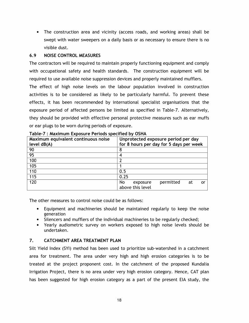
exposure period of affected persons be limited as specified in Table-7. Alternatively,
they should be provided with effective personal protective measures such as ear muffs
or ear plugs to be worn during periods of exposure.
Table-7 : Maximum Exposure Periods specified by OSHA Maximum equivalent continuous noise level dB(A)
Unprotected exposure period per day for 8 hours per day for 5 days per week
90 8
95 4
100 2
105 1
110 0.5
115 0.25
120 No exposure permitted at or above this level
The other measures to control noise could be as follows:
• Equipment and machineries should be maintained regularly to keep the noise generation
• Silencers and mufflers of the individual machineries to be regularly checked;
• Yearly audiometric survey on workers exposed to high noise levels should be undertaken.
7. CATCHMENT AREA TREATMENT PLAN
Silt Yield Index (SYI) method has been used to prioritize sub-watershed in a catchment
area for treatment. The area under very high and high erosion categories is to be
treated at the project proponent cost. In the catchment of the proposed Kundalia
Irrigation Project, there is no area under very high erosion category. Hence, CAT plan
has been suggested for high erosion category as a part of the present EIA study, the
19
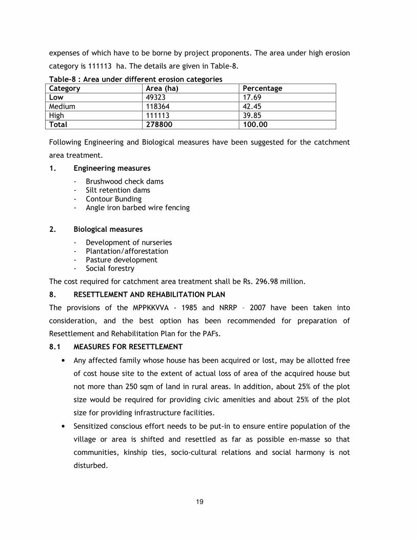
expenses of which have to be borne by project proponents. The area under high erosion
category is 111113 ha. The details are given in Table-8.
Table-8 : Area under different erosion categories Category Area (ha) Percentage Low 49323 17.69
Medium 118364 42.45
High 111113 39.85
Total 278800 100.00 Following Engineering and Biological measures have been suggested for the catchment
area treatment.
1. Engineering measures
- Brushwood check dams - Silt retention dams - Contour Bunding - Angle iron barbed wire fencing
2. Biological measures
- Development of nurseries - Plantation/afforestation - Pasture development - Social forestry
The cost required for catchment area treatment shall be Rs. 296.98 million.
8. RESETTLEMENT AND REHABILITATION PLAN
The provisions of the MPPKKVVA - 1985 and NRRP – 2007 have been taken into
consideration, and the best option has been recommended for preparation of
Resettlement and Rehabilitation Plan for the PAFs.
8.1 MEASURES FOR RESETTLEMENT
• Any affected family whose house has been acquired or lost, may be allotted free
of cost house site to the extent of actual loss of area of the acquired house but
not more than 250 sqm of land in rural areas. In addition, about 25% of the plot
size would be required for providing civic amenities and about 25% of the plot
size for providing infrastructure facilities.
• Sensitized conscious effort needs to be put-in to ensure entire population of the
village or area is shifted and resettled as far as possible en-masse so that
communities, kinship ties, socio-cultural relations and social harmony is not
disturbed.
20
• Conscious effort needs to be put-in to ensure the Scheduled Caste affected
families are resettled in the areas close to the villages, so that they are not
marginalized in the new relocation sites.
• All PAFs losing homestead would be provided with House Building assistance of
Rs. 150,000.
• In case of a project involving land acquisition on behalf of a requiring body, the
stamp duty and other fees payable for registration of the land or house allotted
to the affected families shall be borne by the requiring body.
• The land or house allotted to the affected families under this policy shall be free
from all encumbrances
• The land or house allotted to the affected families under this policy may be in
the joint names of wife and husband of the affected family.
• Each affected family that is displaced and has cattle, shall get financial
assistance of such amount as the appropriate Government may decide but not
less than Rs. 15,000 for construction of cattle shed.
• Each affected family that is displaced shall get a one-time financial assistance of
such amount as the appropriate Government may decide but not less than Rs.
10,000, for shifting of the family, building materials, belongings and cattle.
• Each affected person who is a rural artisan, small trader or self-employed person
and who has been displaced shall get a one-time financial assistance of such
amount as the appropriate Government may decide but not less than Rs. 25,000
for construction of working shed or shop.
• In case of a project involving land acquisition on behalf of a requiring body, each
affected family which is involuntarily displaced shall get a monthly subsistence
allowance equivalent to 25 days minimum agricultural wages per month for a
period of 1 year from the date of displacement.
• Amenities and Infrastructural facilities to be provided at Resettlement Areas.
Such facilities and amenities shall, inter alia, include Internal Village Road
Network, drainage Network within the Resettlement site, sanitation Network
within the Resettlement site, safe drinking water, footpath, public transport,
drinking water trough for cattle, Place of Worship, Cremation grounds, Fair Price
shops and other shops, Post Office, Panchayat Ghar, Community Hall, Health
Care Facility, Garden and children's playground, Educational institutions (schools)

21
in resettlement sites, Space for weekly market,
8.2 MEASURES FOR REHABILITATION
The following measures are suggested to be extended as rehabilitation measures to the
PAFs losing land:
• Based on past experiences, it is observed that a land for land may not be
available in the command area. Thus it is suggested that Rehabilitation grant
may be extended in-lieu of land to PAFs losing land.
• In case of a project involving land acquisition on behalf of a requiring body, the
affected families who have not been provided agricultural land shall be entitled
to a rehabilitation grant equivalent to 750 days minimum agricultural wages or
such other higher amount as may be prescribed by the appropriate Government.
• Fishing rights in the reservoirs shall be given to the affected families, if such
rights were enjoyed by them in the affected area;
• Stamp duty and other fees payable for Registration of the land allotted to the
affected families shall be borne by the requiring body.
• Land allotted to the affected families under this policy shall be free from all
encumbrances.
• Land allotted to the affected families under this policy may be in the joint names
of wife and husband of the affected family.
• In case each khatedar in the affected family is allotment of wasteland or
degraded land in lieu of the acquired land, s/he shall be entitled for a one-time
"financial assistance of not less than Rs. 15,000/ha for land development.
• A provision of Rs. 10,000 per PAFis being kept for a one-time financial assistance
to each khatedar in the affected family for agricultural production
• Preference to given to atleast one person per affected family in providing
employment in the project, subject to the availability of vacancies and
suitability of the affected person for the employment.
• A provision of Rs. 500/month for 6 months for one person per PAF shall be given
for training.
• Scholarship @ Rs. 500 per month to atleast 1 child per PAF for a period of 1 year.
• A provision of Rs. 500/month for 6 months for one person per PAF shall be given
to extend other skill development opportunities to eligible persons.
22
• Requiring body shall give preference to willing landless labourers and
unemployed affected persons while engaging labour in the project during the
construction phase.
• One person from each affected family shall be offered necessary training
facilities for development of entrepreneurship, technical and professional skills
for self-employment.
8.3 BUDGET
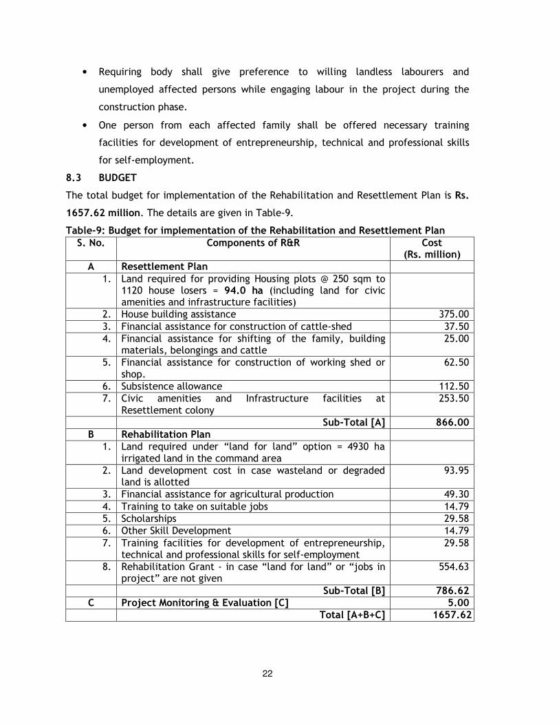
The total budget for implementation of the Rehabilitation and Resettlement Plan is Rs.
1657.62 million. The details are given in Table-9.
Table-9: Budget for implementation of the Rehabilitation and Resettlement Plan
S. No. Components of R&R Cost (Rs. million)
A Resettlement Plan
1. Land required for providing Housing plots @ 250 sqm to 1120 house losers = 94.0 ha (including land for civic amenities and infrastructure facilities)
2. House building assistance 375.00
3. Financial assistance for construction of cattle-shed 37.50
4. Financial assistance for shifting of the family, building materials, belongings and cattle
25.00
5. Financial assistance for construction of working shed or shop.
62.50
6. Subsistence allowance 112.50
7. Civic amenities and Infrastructure facilities at Resettlement colony
253.50
Sub-Total [A] 866.00 B Rehabilitation Plan
1. Land required under “land for land” option = 4930 ha irrigated land in the command area
2. Land development cost in case wasteland or degraded land is allotted
93.95
3. Financial assistance for agricultural production 49.30
4. Training to take on suitable jobs 14.79
5. Scholarships 29.58
6. Other Skill Development 14.79
7. Training facilities for development of entrepreneurship, technical and professional skills for self-employment
29.58
8. Rehabilitation Grant - in case “land for land” or “jobs in project” are not given
554.63
Sub-Total [B] 786.62 C Project Monitoring & Evaluation [C] 5.00
Total [A+B+C] 1657.62
23
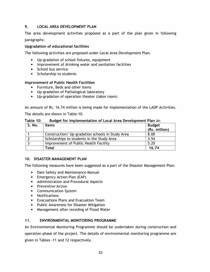
9. LOCAL AREA DEVELOPMENT PLAN
The area development activities proposed as a part of the plan given in following
paragraphs:
Upgradation of educational facilities
The following activities are proposed under Local Area Development Plan:
• Up-gradation of school fixtures, equipment
• Improvement of drinking water and sanitation facilities
• School bus service
• Scholarship to students Improvement of Public Health Facilities
• Furniture, Beds and other items
• Up-gradation of Pathological laboratory
• Up-gradation of operation theater (labor room)
An amount of Rs. 16.74 million is being made for implementation of the LADP Activities.
The details are shown in Table-10.
Table 10: Budget for implementation of Local Area Development Plan An
S. No. Items Budget (Rs. million)
1 Construction/ Up-gradation schools in Study Area 8.00
2 Scholarships to students in the Study Area 3.54
3 Improvement of Public Health Facility 5.20
Total 16.74
10. DISASTER MANAGEMENT PLAN
The following measures have been suggested as a part of the Disaster Management Plan:
• Dam Safety and Maintenance Manual
• Emergency Action Plan (EAP)
• Administration and Procedural Aspects
• Preventive Action
• Communication System
• Notifications
• Evacuations Plans and Evacuation Team
• Public Awareness for Disaster Mitigation
• Management after receding of Flood Water
11. ENVIRONMENTAL MONITORING PROGRAMME
An Environmental Monitoring Programme should be undertaken during construction and
operation phase of the project. The details of environmental monitoring programme are
given in Tables -11 and 12 respectively.
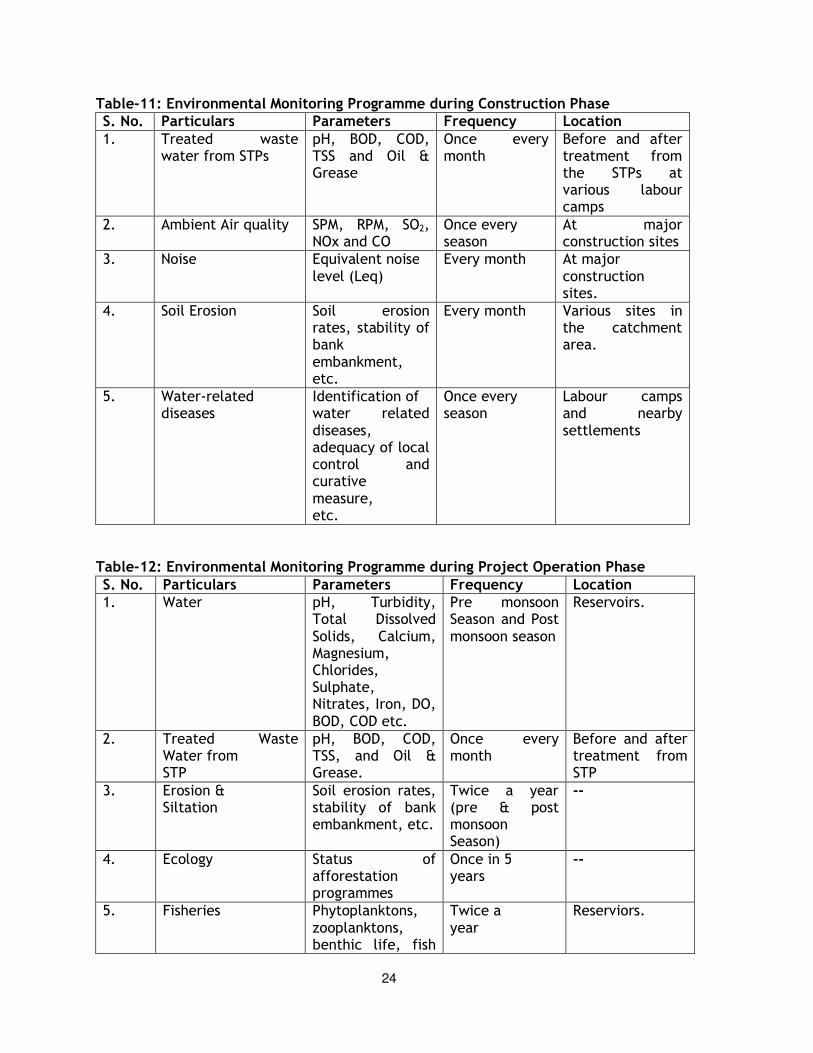
24
Table-11: Environmental Monitoring Programme during Construction Phase S. No. Particulars Parameters Frequency Location
1. Treated waste water from STPs
pH, BOD, COD, TSS and Oil & Grease
Once every month
Before and after treatment from the STPs at various labour camps
2. Ambient Air quality SPM, RPM, SO2, NOx and CO
Once every season
At major construction sites
3. Noise Equivalent noise level (Leq)
Every month At major construction sites.
4. Soil Erosion Soil erosion rates, stability of bank embankment, etc.
Every month Various sites in the catchment area.
5. Water-related diseases
Identification of water related diseases, adequacy of local control and curative measure, etc.
Once every season
Labour camps and nearby settlements
Table-12: Environmental Monitoring Programme during Project Operation Phase
S. No. Particulars Parameters Frequency Location 1. Water pH, Turbidity,
Total Dissolved Solids, Calcium, Magnesium, Chlorides, Sulphate, Nitrates, Iron, DO, BOD, COD etc.
Pre monsoon Season and Post monsoon season
Reservoirs.
2. Treated Waste Water from STP
pH, BOD, COD, TSS, and Oil & Grease.
Once every month
Before and after treatment from STP
3. Erosion & Siltation
Soil erosion rates, stability of bank embankment, etc.
Twice a year (pre & post monsoon Season)
--
4. Ecology Status of afforestation programmes
Once in 5 years
--
5. Fisheries Phytoplanktons, zooplanktons, benthic life, fish
Twice a year
Reserviors.
25
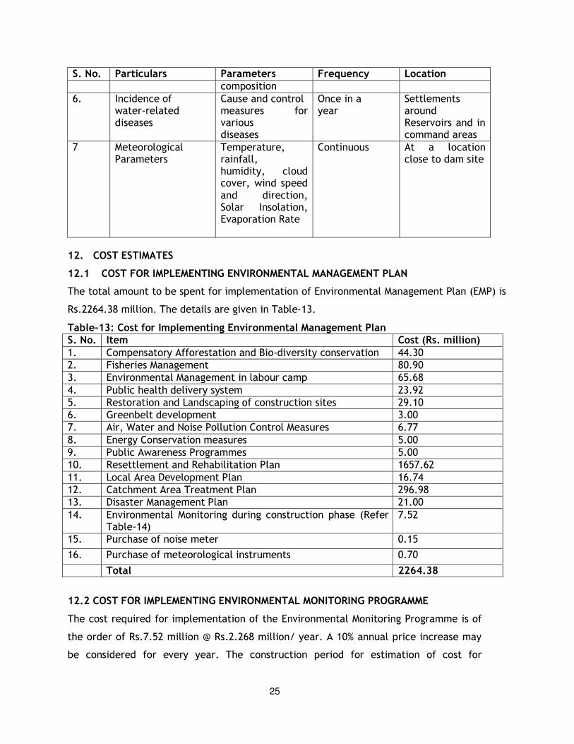
S. No. Particulars Parameters Frequency Location composition
6. Incidence of water-related diseases
Cause and control measures for various diseases
Once in a year
Settlements around Reservoirs and in command areas
7 Meteorological Parameters
Temperature, rainfall, humidity, cloud cover, wind speed and direction, Solar Insolation, Evaporation Rate
Continuous At a location close to dam site
12. COST ESTIMATES
12.1 COST FOR IMPLEMENTING ENVIRONMENTAL MANAGEMENT PLAN
The total amount to be spent for implementation of Environmental Management Plan (EMP) is
Rs.2264.38 million. The details are given in Table-13.
Table-13: Cost for Implementing Environmental Management Plan S. No. Item Cost (Rs. million)
1. Compensatory Afforestation and Bio-diversity conservation 44.30
2. Fisheries Management 80.90
3. Environmental Management in labour camp 65.68
4. Public health delivery system 23.92
5. Restoration and Landscaping of construction sites 29.10
6. Greenbelt development 3.00
7. Air, Water and Noise Pollution Control Measures 6.77
8. Energy Conservation measures 5.00
9. Public Awareness Programmes 5.00
10. Resettlement and Rehabilitation Plan 1657.62
11. Local Area Development Plan 16.74
12. Catchment Area Treatment Plan 296.98
13. Disaster Management Plan 21.00
14. Environmental Monitoring during construction phase (Refer Table-14)
7.52
15. Purchase of noise meter 0.15
16. Purchase of meteorological instruments 0.70
Total 2264.38
12.2 COST FOR IMPLEMENTING ENVIRONMENTAL MONITORING PROGRAMME
The cost required for implementation of the Environmental Monitoring Programme is of
the order of Rs.7.52 million @ Rs.2.268 million/ year. A 10% annual price increase may
be considered for every year. The construction period for estimation of cost for
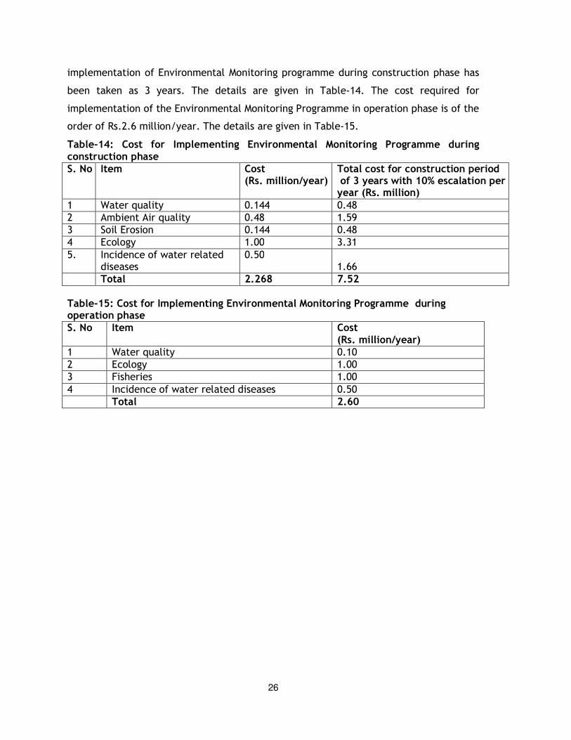
26
implementation of Environmental Monitoring programme during construction phase has
been taken as 3 years. The details are given in Table-14. The cost required for
implementation of the Environmental Monitoring Programme in operation phase is of the
order of Rs.2.6 million/year. The details are given in Table-15.
Table-14: Cost for Implementing Environmental Monitoring Programme during construction phase S. No Item Cost
(Rs. million/year) Total cost for construction period of 3 years with 10% escalation per year (Rs. million)
1 Water quality 0.144 0.48
2 Ambient Air quality 0.48 1.59
3 Soil Erosion 0.144 0.48
4 Ecology 1.00 3.31
5. Incidence of water related diseases
0.50 1.66
Total 2.268 7.52
Table-15: Cost for Implementing Environmental Monitoring Programme during operation phase S. No Item Cost
(Rs. million/year) 1 Water quality 0.10
2 Ecology 1.00
3 Fisheries 1.00
4 Incidence of water related diseases 0.50
Total 2.60