Embed Size (px)
Citation preview
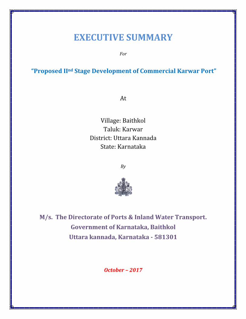
EXECUTIVE SUMMARY
For
“Proposed IInd Stage Development of Commercial Karwar Port”
At
Village: Baithkol
Taluk: Karwar
District: Uttara Kannada
State: Karnataka
By
M/s. The Directorate of Ports & Inland Water Transport.
Government of Karnataka, Baithkol
Uttara kannada, Karnataka - 581301
October – 2017
EXECUTIVE SUMMARY
1. Introduction
1.1 Project background
Karwar port is a natural all weather port, situated at the Northern extremity of sea coast of
Karnataka in Uttar Kannada District. The port is located between the two major ports i.e., 70
Km’s South of Mormugao and 276 Km North of New Mangalore Port. The port is located in the
shelter of Karwar Head, which gives a great measure of protection to the Karwar Bay from
South West Monsoon waves to form a natural harbour. The geographical characteristics and
positioning of Karwar port qualifies Karwar as an all-weather port in the country.
With the growing cargo traffic across the Indian coastline, development of high quality port
infrastructure with commodity focus is imperative and this has been recognised by the
Government. As on May 2011, major ports in India have a total of 233 berths, 5 single buoy
moorings and two barge jetties to handle cargo traffic. Including the non-major ports would
account for more than 300 berths. However, it must be noted that Indian Ports largely continue
to remain dominated by multipurpose berth (approximately 60%), which evidently is falling short
of specialised commodity focussed requirements.
Based on preliminary study it is found that Mormugaon will be the major competing port,
followed by New Mangalore, Vishakapatnam, Krishnapatnam and Tadadi in decreasing order of
their threat to Karwar port’s traffic. However it should be noted that although currently Tadadi is
not a threat to Karwar, developing Tadadi will have significant amount of hinterland overlap with
Karwar which may be a cause of concern for the developer.
1.2 Overview of Karwar Port
M/s. Karwar Port at Karwar is an all-weather intermediate port with an available draft of 6.5 –
9.5. The prestigious INS Kadamba Naval base is located very near to the port. The total traffic
volume handled is 3Million TPA.
This port has been developed as an all weather port in the Karwar bay with 355m long quay for
accommodating simultaneous berthing of two ships with other matching infrastructure facilities.
At present it caters to vessels with draft of 8.5m only due to under water physical obstruction in
front of berths. The port is declared for handling of all types of commodities including class ‘B’
and class ‘C’ petroleum products.
Presently Karwar port handles import and export of about 3 million tonnes of various
commodities including class ‘B and class ‘C’ petroleum products per year. INS Kadamba is a
naval base at Arga village of Karwar which is used exclusively for berthing of naval vessels. A
naval ship repair yard (dry Docks) is also attached to it.
M/s. Karwar Port was established in25 years back. It is located at Baithkol village, Karwar Taluk,
Uttara KannadaDistict, Karnataka state.
1.3 Location of Project site
The proposed site is located at Baithkol Village, Karwar Taluk, Uttara kannada district of
Karnataka. The site is about 17Ha and falls in 57 J/1 of SOITopo sheet and spatial location of
the site is 140 48’ 01.73” N & 740 06’ 55.30” E.
1.4 Need for the study
All projects related to sea ports, harbour, jetties, marine terminals, break water and dredging
development have been identified as category – A & B projects in the EIA notification issued by
MoEF in Sep 2006. Environmental Impact Assessment (EIA) for ports and harbours is a
mandatory requirement as per the MoEF EIA Sep 14, 2006 and is also governed under CRZ
notification Feb 19, 1991 (As amended in Jan 25, 2005) as these projects can cause potential
environmental impacts. Public hearing has been made mandatory for all the cases where the
environmental clearance is required. It is however, not necessary to obtain site clearance or
permission to conduct surveys.
2. Project Description
M/s. The Directorate of Ports and Inland water Transportproposed to IInd stage development of
commercial Karwar port at Karwar for Import and Export of various products like Iron Ores,
Manganese Ore, Bauxite, Sugar, Alumina, Food Grains, Granite, Coal, Cement, Sugar,
Fertilizers, and Bitumen etc.
The imported products will be transported through Tankers and Trucks based on the market
demand.
2.1. Cost of the Project
The total capital investment on the project is INR 1993.54 Crores.
3 Description of Environment
Project Influence Area (PIA)/Study Area: A 10 km radial distance with the proposed project
site as the epicentre has been identified as the General study area for assessing the baseline
environmental status. The core study area is the project area and its immediate surroundings
to the tune of 1.0 km radius from the boundary. The project area is the reclaimed land where
the proposed IInd stage karwar port is being developed. Further the Project Impact Area (PIA) is
10km from the boundary of the core area covering KarwarTaluka under uttarakannada district.
Monitoring Period: - April to May 2017.
3.2 Ambient Air Quality
To evaluate the baseline air quality of the study area, Four (04) monitoring locations have been
identified as per IMD Climatological data-Karwar Region (1971-2000).The annual wind
predominat is from North West to South East. The variations of the pollutants PM10, PM2.5, SO2,
NO2, CO, Pb, O3, NH3, C6H6, C20 H12, As & Ni, are compared with National Ambient Air Quality
Standards (NAAQS), MoEF&CC Notification, November, 2009. All values are found within the
stipulated standards.
3.3 Noise Environment
Ambient noise levels have been established by monitoring noise levels at Four (04) locations in
and around 10Km distance from project area during the study period using precision noise level
meter. The noise monitoring locations in the study area were selected after giving due
consideration to the various land use categories. The land use categories include commercial,
residential, rural and sensitive areas. Noise levels were recorded on an hourly basis for one
complete day at each location using pre- calibrated noise levels.
Values are ranging from 42-61 dB (A) at Day time and 45 - 55 dB (A) at night time.
3.4 Water Environment
Surface Water
The prevailing status of surface water quality of Kali River at upstream and downstream has
been assessed during the study period. Marine samples were also collected to assess the water
quality and to identify dominant zooplankton groups present in the samples.
pH is varying from 7.89 to 7.97
TDS is varying from 21450 to 23800
Hardness is varying from 4900 to 6700
EC is varying from 42900 to 47800
Chlorides is varying from 18063.19 to 19547.83
Sulphates is varying from 287.42 to 2135.46
Nitrates is varying from BDL to 1.76
Fluorides is varying from 0.12 to 0.22
Also give marine samples, which are important
Ground Water
Total Four(04) ground water monitoring locations were identified for assessment in different
villages around the project site based on the usage of sub surface water by the settlements/
villages in the study area. The groundwater results are compared with the desirable and
permissible water quality standards as per IS: 10500 (2012) for drinking water.
pH is varying from 6.23 to 7.95
TDS is varying from BDL to 10
Hardness is varying from BDL to 2400
EC is varying from 211 to 754
Chlorides is varying from 15.83 to 64.33
Sulphates is varying from 3.81 to 65.53
Nitrates is varying from 0.6 to 33.82
Fluorides is varying from 0.18 to 0.25
3.5 Socio – Economic
The occupation profile of the area is non- agriculture due to the urbanisation and
industrialization of the area.
Of the total working population, 82.8% of them belong to the main workers category, i.e the
majority of the working population engaged in any occupation more than a six months in a year.
Those who involved in the agricultural work are 4.69% of the total workers. The major (92.12%)
workforce involved in the other activities like industrial workers, teachers, Government officials
etc.
4 Anticipated Environmental Impacts & Mitigation Measures
The major activities associated with development of port are given inTable 1.
Table 1: Major Activities Proposed during Different Stages of Port Development
Details of the parameters likely to be affected by each of the activities taking placeduring
construction and operation phases of the port, with their impact characteristics andlevel of
significance with low cost EMP are summarized in Tables 2 and 3 respectively.
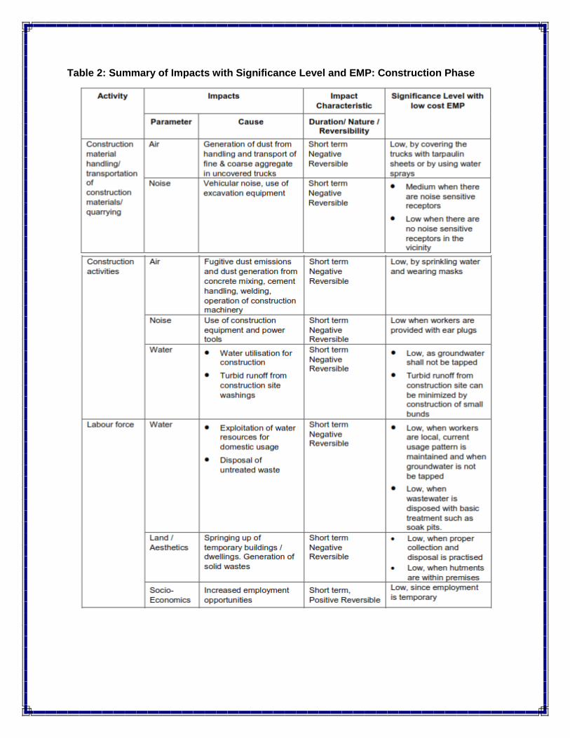
Table 2: Summary of Impacts with Significance Level and EMP: Construction Phase
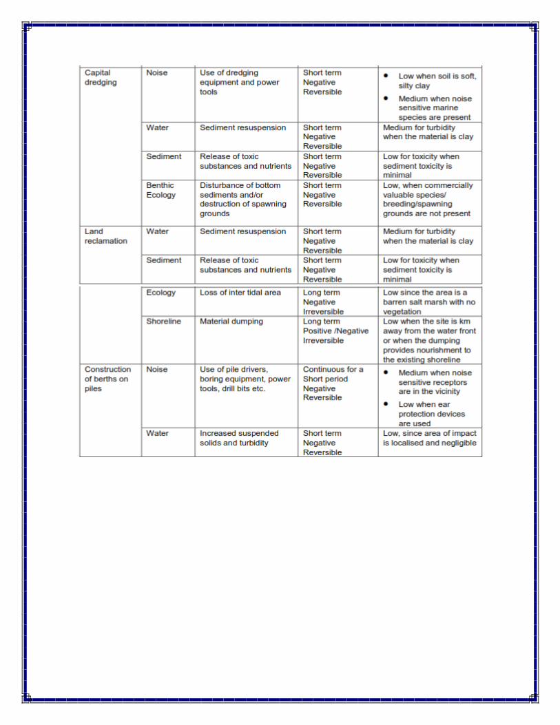
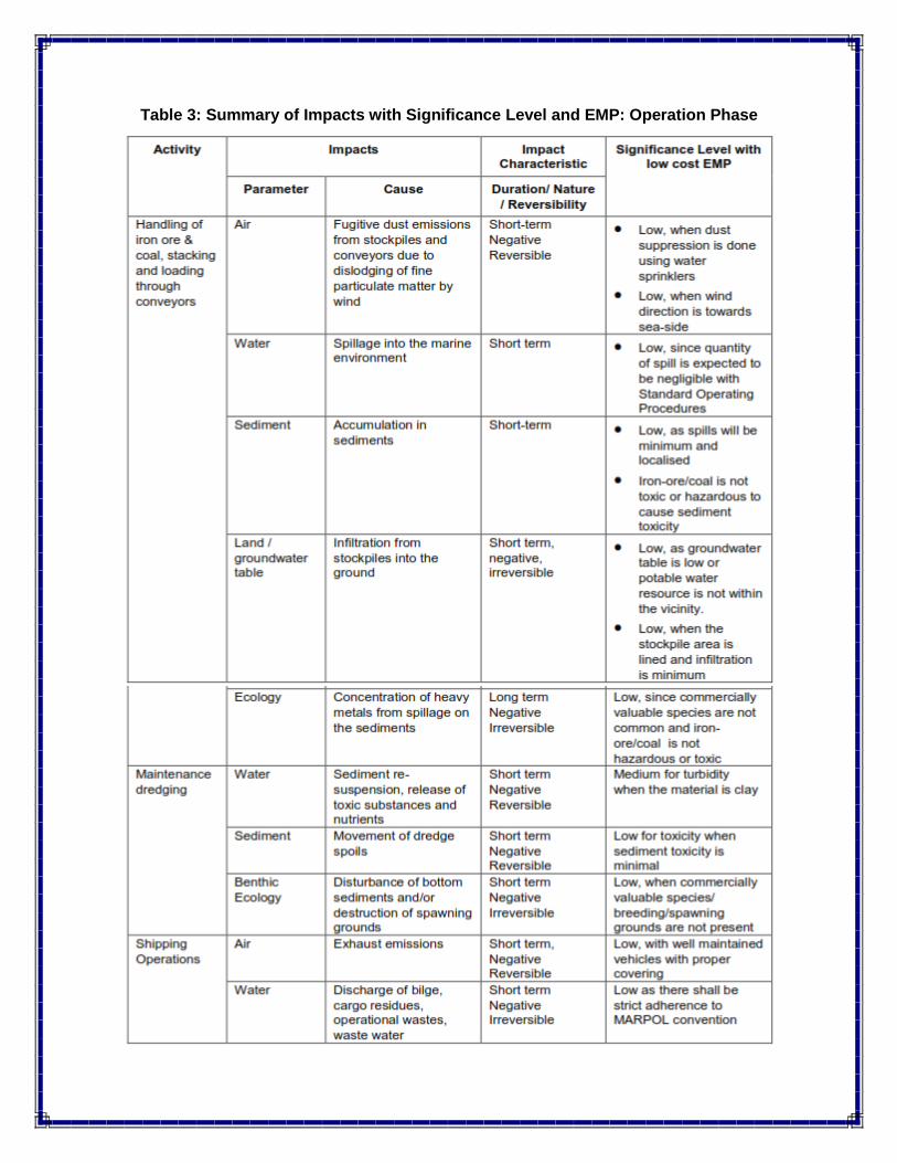
Table 3: Summary of Impacts with Significance Level and EMP: Operation Phase
9.2 Conclusion
Considering the increasing demand for port services and trends in the traffic at Karwar
Port, there is potential to develop and expand the facilities for meeting the requirements
of trade.
Development of IInd Stage of Karwar Port, with deepened drafts and addition of berths,
would facilitate receiving larger parcel sizes.
The commodity mix would include 22.95% dry bulk, 69.90% liquid bulk, 0.58% container
cargo, and 6.57% general and other cargo.
Karwar will be highly dependent on primary hinterland comprising Uttar Kannada,
Shimoga, Belgaum, Haveri, Koppal, Bagalkot, Devangere and Bellary. While the
secondary hinterland would include few districts from Southern Maharashtra and
western Andhra Pradesh, development of ports like Tadadi and Haldipur and expansions
at Mormugaon, NMPT and Krishnapatnam will substantially reduce the possibility of
traffic emerging from secondary hinterland.
Even under the best case scenario, the capacity utilization touches 100% only during the
21st year of operation. Hence, it may be apt to let the concessionaire decide on the
phase-wise implementation of the project rather than implementation of the entire project
in the first three years.
In consideration of the above, it may be apt to allow the concessionaire the flexibility to
develop the project as felt needed by the concessionaire. This could improve the viability
of the project.


![[XLS]kspcb.kar.nic.inkspcb.kar.nic.in/RTI_cfe_cfo_list/Bidar_rti.xls · Web viewM.S Patil Function Hall Near Kumbarwada Cross, Manhalli Road, Bidar 17/05/2007 Sri Venkatsai Organics,](https://img.pdfslide.us/doc/110x75/5affd7b37f8b9a0c028bd39c/xlskspcbkarnic-viewms-patil-function-hall-near-kumbarwada-cross-manhalli.jpg)


![[XLS]kspcb.kar.nic.inkspcb.kar.nic.in/RTI_cfe_cfo_list/2008-09issue by BO.xls · Web viewColombia Asia Referral Hospital, Khata No.338,Hebbal Kirloskar Business Park, HA Farm Post,Kempapura,](https://img.pdfslide.us/doc/110x75/5b08bf8b7f8b9a93738cde49/xlskspcbkarnic-by-boxlsweb-viewcolombia-asia-referral-hospital-khata-no338hebbal.jpg)

![[XLS]kspcb.kar.nic.inkspcb.kar.nic.in/RTI_cfe_cfo_list/Karwar_rti.xls · Web viewThe Kanara Tile & Clay Industries Pvt.Ltd., Divgi Village, Kumta Anmod Plast, Anmod, Jida. Chitrapur](https://img.pdfslide.us/doc/110x75/5aa26b097f8b9a84398d0799/xlskspcbkarnic-viewthe-kanara-tile-clay-industries-pvtltd-divgi-village.jpg)