Embed Size (px)
Citation preview
Krishnapatnam Port Company Limited
Development of Phase-III at Krishnapatnam Port,
Sri Potti Sriramulu Nellore Dist
Pre-Feasibility Report
December 2015
KRISHNAPATNAM PORT COMPANY LIMITED
Regd.Off: H.No. 8-2-293/82/A/379&379A, Ground Floor, Plot No. 379, Road No.10,
Jubilee Hills, Hyderabad – 500033, India. Tel: +91-40-23339990/91/92 Fax: +91-40-23337789
E-mail: [email protected] www.krishnapatnamport.com
PDF compression, OCR, web optimization using a watermarked evaluation copy of CVISION PDFCompressor
Krishnapatnam Port Co. Ltd. December 2015
Pre-Feasibility Report - Phase III i
TABLE OF CONTENTS
1.0 EXECUTIVE SUMMARY 1-1
1.1 Preamble 1-1 1.2 External Road and Rail Connectivity 1-1 1.3 Need for Phase III Development 1-2 1.4 Planning Considerations 1-2 1.5 Infrastructure Proposals of Phase III Development 1-3 1.6 Review of Land use Plan 1-8 1.7 Estimated Capital Cost of Phase III, Viability, Implementation Period 1-8 1.8 Environmental Aspects 1-8 1.9 Social Benefits 1-9
2.0 INTRODUCTION 2-1
2.1 Identification of the Project and Project Proponent 2-1 2.2 Brief Description of the Nature of the Project 2-2 2.3 Need for the Project and its Importance to the Country and Region 2-2 2.3.1 Preamble 2-2 2.4 Traffic Forecast 2-4 2.4.1 Coal 2-5 2.4.2 Iron Ore 2-5 2.4.3 General Cargo 2-6 2.4.4 Liquid Cargo 2-8 2.4.5 Container Cargo 2-9 2.4.6 Port Craft Berthing and Repair Needs 2-9 2.4.7 Coast Guard Jetty 2-9 2.5 Importance to the Country and the Region 2-9 2.6 Demand Supply Gap 2-11 2.7 Import Vs Indigenous Production 2-12 2.8 Export Possibility 2-12 2.9 Domestic/Export Markets 2-13 2.10 Employment Generation Due to the Project 2-13
3.0 PROJECT DESCRIPTION 3-1
3.1 General 3-1
3.2 Type of project Including Interlinked and Interdependent projects 3-2
3.3 Location 3-3
3.4 Details of alternate site 3-4
3.5 Size or magnitude of Operation 3-4
3.6 Project Description with Process Details 3-5
3.7 Raw Material Required along with Estimated quantity 3-7
3.8 Resource Optimization / Recycling and Reuse Envisaged in the project 3-8
3.9 Availability of water, its source, Energy / Power requirement 3-8
3.9.1 Water Requirement 3-8
PDF compression, OCR, web optimization using a watermarked evaluation copy of CVISION PDFCompressor
Krishnapatnam Port Co. Ltd. December 2015
Pre-Feasibility Report - Phase III ii
3.9.2 Power Requirement 3-9
3.9.3 Quantity of Wastes to be generated 3-9
3.10 Schematic representations of the feasibility drawing 3-10
4.0 SITE ANALYSIS 4-1
4.1 Connectivity 4-1
4.2 Land Form, Land Use and Land Ownership 4-1
4.3 Topography (along with Map) 4-2
4.4 Existing Land Use Pattern 4-3
4.4.1 Straightening of Creek 4-5
4.4.2 Development of Mangroves 4-5
4.4.3 Shore Protection- South of South Breakwater 4-6
4.4.4 Shore Protection North of North Breakwater 4-6
4.4.5 Maintaining Existing Drainage 4-6
4.5 Existing Infrastructure 4-6
4.5.1 General 4-7
4.5.2 Berthing Front 4-7
4.5.3 Marine Infrastructure 4-7
4.5.4 Navigational Aids 4-8
4.5.5 Storage Yards 4-8
4.5.6 Road/ Rail /pipe line network 4-8
4.5.7 Drainage 4-9
4.5.8 Water Supply 4-9
4.5.9 Other Infrastructure 4-9
4.6 Shore Line and Littoral Drift 4-10
4.7 Soil 4-11
4.8 Climatic data from Secondary sources 4-12
4.8.1 Climate 4-12
4.8.2 Temperature 4-12
4.8.3 Humidity 4-12
4.8.4 Visibility 4-12
4.8.5 Rainfall 4-13
4.8.6 Currents 4-13
4.8.7 Tidal Data 4-13
4.8.8 Wind 4-14
4.8.9 Wave data 4-14
4.8.10 Harbour Tranquillity 4-15
4.8.11 Cyclones 4-17
4.9 Social Infrastructure Available 4-17
PDF compression, OCR, web optimization using a watermarked evaluation copy of CVISION PDFCompressor

Krishnapatnam Port Co. Ltd. December 2015
Pre-Feasibility Report - Phase III iii
5.0 PLANNING BRIEF 5-1
5.1 Planning Concept 5-1
5.1.1 Design Vessel Size 5-1
5.1.2 Navigational and Operational Requirements 5-2
5.1.2.1 Navigable Channel 5-3
5.1.2.2 Stopping Distance 5-6
5.1.2.3 Turning Circle Dimensions and Depth at Berths 5-7
5.1.3 Berthing Requirements 5-8
5.1.3.1 Parcel Size and Cargo Handling Rates 5-8
5.1.3.2 Effective Working Days and Working Hours Per
Day 5-10
5.1.3.3 Time for berthing / De-berthing and Peripheral
Activities 5-10
5.1.3.4 Berth Occupancy 5-11
5.1.3.5 Requirement of Berths and Quay Length 5-14
5.1.4 Berthing and Repair Facility including dry dock for Port Crafts,
Naval & Commercial Vessels 5-15
5.1.4.1 Port Craft Jetty 5-16
5.1.4.2 Coast Guard Jetty 5-16
5.1.4.3 Dry Docking, Berthing and repair Facility 5-17
5.1.5 Dry Dock Facility 5-17
5.1.6 Cargo Storage Area Requirements 5-18
5.1.6.1 Storage for Coal 5-18
5.1.6.2 Container Storage Area 5-19
5.1.6.3 General Cargo 5-20
5.1.6.4 Liquid Cargo 5-21
5.1.6.5 Total Cargo Storage Area Requirement 5-22
5.1.7 Cargo Handling Equipment 5-23
5.1.8 Shore Protection near South & North Breakwaters 5-26
5.2 Population Projection 5-27
5.3 Development Strategy 5-28
5.4 Study of Alternative Layouts 5-28
5.4.1 Alternative I 5-30
5.4.2 Alternative II 5-30
5.4.3 Evaluation of Alternative Layouts 5-30
5.5 Recommended Port Layout 5-33
5.6 Land use Planning 5-36
5.7 Dredging 5-36
5.8 Maintenance Dredging 5-38
5.9 Reclamation 5-38
PDF compression, OCR, web optimization using a watermarked evaluation copy of CVISION PDFCompressor
Krishnapatnam Port Co. Ltd. December 2015
Pre-Feasibility Report - Phase III iv
5.10 Assessment of Infrastructure Demand 5-38
5.10.1 Road connectivity 5-38
5.10.2 Railway connectivity 5-39
5.10.3 Bridges 5-40
5.10.4 Service Corridor 5-41
5.10.5 Water Requirement 5-41
5.10.6 Power Requirement 5-42
5.10.7 Buildings 5-43
5.11 Amenities / Facilities 5-44
5.11.1 Navigational Aids 5-44
5.11.2 Port Craft 5-44
5.11.3 General Lighting 5-44
5.11.4 Storm Water Drainage 5-44
5.11.5 Bunkering 5-45
5.11.6 Environmental Aspects 5-45
6.0 PROPOSED INFRASTRUCTURE 6-1
6.1 Port Area (Processing Area) 6-1
6.1.1 Infrastructure Proposed in Phase III 6-1
6.1.2 Designation of Berths 6-7
6.1.3 Navigable Waterways 6-7
6.1.4 Summary of Infrastructure Required in Phase III 6-8
6.2 Non-Operational Area (Non Processing Area) 6-11
6.3 Green Belt 6-11
6.4 Social Infrastructure 6-11
6.5 Connectivity (Traffic and Transportation Road / Rail /
Water ways etc.) 6-12
6.5.1 Rail 6-12
6.5.2 Road 6-12
6.5.3 Waterways 6-13
6.6 Drinking Water Management (Source & Supply of Water) 6-13
6.7 Sewerage System 6-13
6.8 Industrial Waste Management 6-14
6.9 Solid Waste Management 6-14
6.10 Power Requirement & Supply / Source 6-14
7.0 REHABILATATION AND RESETTLEMENT (R&R) PLAN 7-1
PDF compression, OCR, web optimization using a watermarked evaluation copy of CVISION PDFCompressor
Krishnapatnam Port Co. Ltd. December 2015
Pre-Feasibility Report - Phase III v
8.0 PROJECT IMPLEMENTATION SCHEDULE AND COST
ESTIMATES 8-1 8.1 General 8-1
8.2 Proposed Development 8-1
8.3 Time Schedule 8-2
8.3.1 Civil Works 8-2
8.3.1.1 Dredging and Reclamation 8-2
8.3.1.2 Berth Construction 8-2
8.3.1.3 Shore Protection on the windward side of
the Breakwaters 8-3
8.3.2 Mechanical and Electrical works 8-3
8.3.3 Onshore Development 8-3
8.3.3.1 Buildings 8-3
8.3.3.2 Stockyards 8-3
8.3.3.3 Road and Rail 8-4
8.3.3.4 Utilities and Environmental Aspects 8-4
8.4 Capital Cost Estimates for Phase III Development 8-4
PDF compression, OCR, web optimization using a watermarked evaluation copy of CVISION PDFCompressor
Krishnapatnam Port Co. Ltd. December 2015
Pre-Feasibility Report - Phase III vi
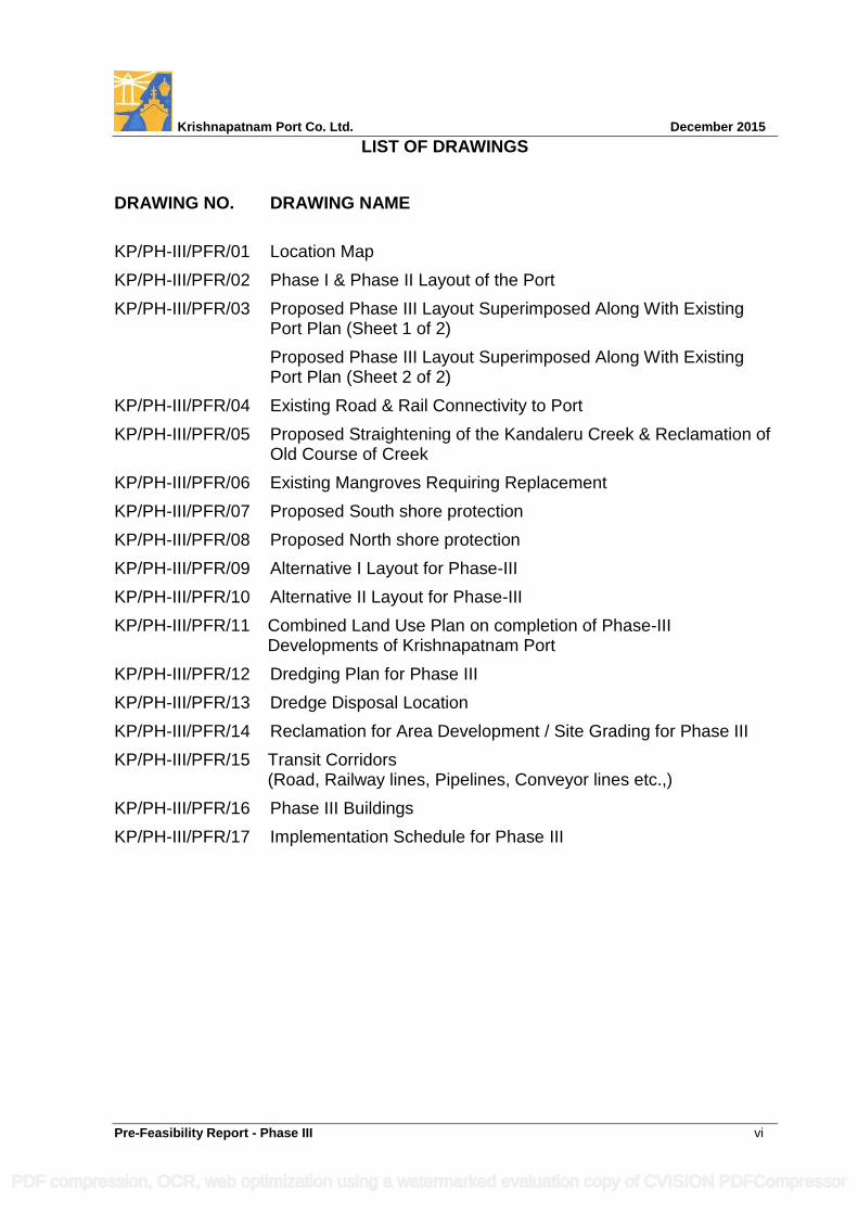
LIST OF DRAWINGS
DRAWING NO. DRAWING NAME
KP/PH-III/PFR/01 Location Map
KP/PH-III/PFR/02 Phase I & Phase II Layout of the Port
KP/PH-III/PFR/03 Proposed Phase III Layout Superimposed Along With Existing Port Plan (Sheet 1 of 2)
Proposed Phase III Layout Superimposed Along With Existing Port Plan (Sheet 2 of 2)
KP/PH-III/PFR/04 Existing Road & Rail Connectivity to Port
KP/PH-III/PFR/05 Proposed Straightening of the Kandaleru Creek & Reclamation of Old Course of Creek
KP/PH-III/PFR/06 Existing Mangroves Requiring Replacement
KP/PH-III/PFR/07 Proposed South shore protection
KP/PH-III/PFR/08 Proposed North shore protection
KP/PH-III/PFR/09 Alternative I Layout for Phase-III
KP/PH-III/PFR/10 Alternative II Layout for Phase-III
KP/PH-III/PFR/11 Combined Land Use Plan on completion of Phase-III Developments of Krishnapatnam Port
KP/PH-III/PFR/12 Dredging Plan for Phase III
KP/PH-III/PFR/13 Dredge Disposal Location
KP/PH-III/PFR/14 Reclamation for Area Development / Site Grading for Phase III
KP/PH-III/PFR/15 Transit Corridors (Road, Railway lines, Pipelines, Conveyor lines etc.,)
KP/PH-III/PFR/16 Phase III Buildings
KP/PH-III/PFR/17 Implementation Schedule for Phase III
PDF compression, OCR, web optimization using a watermarked evaluation copy of CVISION PDFCompressor

Krishnapatnam Port Co. Ltd. December 2015
Pre-Feasibility Report -Phase III 1-1
1. EXECUTIVE SUMMARY
1.1 Preamble
Krishnapatnam Port, a non-major port on the east coast of India in the state of
Andhra Pradesh existing since 1825, is being developed by Krishnapatnam Port
Company Ltd (KPCL) into an all-weather, deep water, multi-purpose port through
Public Private Participation on BOST (Build Operate Share Transfer) concession
basis in terms of a Concession Agreement entered into with GoAP during 2004. The
Phase I & II developments of Krishnapatnam Port comprising of 17 berths with
required marine infrastructure viz., breakwaters, navigational water ways and shore
infrastructure like cargo handling equipment, cargo storage areas, roads and drains,
railways, bridges, conveyors, pipelines, water supply, drainage, sewage treatment,
power supply, area illumination, offices, operational, functional, welfare and control
buildings, amenities, dust suppression measures, greenbelt, mangrove development,
environmental measures etc. are under progress in a designated land area of
Ha.1,240 (Ac. 3,064 acres) to cater to 72.3 MTPA of various types of cargo plus 3.3
MTEUsPA of container traffic in terms of the EC & CRZ Clearances accorded by the
MoEF during 2006 & 2009 respectively for Phases I & II. About 70% of the planned
port infrastructure is developed so far and development of balance planned
infrastructure is under progress.
GoAP have sanctioned land to the extent of Ha.2,752 (Ac. 6,800) of land for the
development of Krishnapatnam Port . Land required for the port development is
being leased by the GoAP in terms of the Concession Agreement. GoAP have also
been implementing the required rehabilitation and resettlement schemes in the
project affected villages. KPCL is augmenting the same under its CSR initiatives.
1.2 External Road and Rail Connectivity
A dedicated 23 Km long four lane road connectivity (feasible to widen to 6 lanes)
from Krishnapatnam Port to the National Highway No. 16 has been formed by the
GoAP as an external infrastructure. A 19.40 Km long electrified double line rail
connectivity from Krishnapatnam Port connecting to the to the National Rail Grid
near Venkatachalam Station has been formed by a JV of RVNL, KPCL, GoAP &
NMDC.
PDF compression, OCR, web optimization using a watermarked evaluation copy of CVISION PDFCompressor
Krishnapatnam Port Co. Ltd. December 2015
Pre-Feasibility Report -Phase III 1-2
1.3 Need for Phase III Development
During the past decade, India is experiencing a rapid growth in economic
development. As per the Maritime Agenda of Ministry of Shipping, Indian ports,
which have a capacity to handle cargo traffic of about 1,240.4 MTPA by 2012, have
to plan and augment to a capacity level of 2,600 MTPA by the year 2016-17 and
3,100 MTPA by 2019-20. To cater to the projected increase in traffic volumes,
augmentation of the port infrastructure is essential and development of India’s ports
and trade related infrastructure will continue to be critical to sustain the success of
accelerated growth of Indian economy. Krishnapatnam Port is also called upon to
augment the cargo handling capacity commensurately.
According to traffic forecast studies undertaken by Krishnapatnam Port duly
engaging reputed consultants, the cargo handling through Krishnapatnam Port by
2025-26 would be of the order of 226 MTPA of various types of cargo plus 5.5
MTEUsPA of container cargo as against the port capacity being developed as
approved during the Phase I & II developments i.e., 72.3 MTPA of various cargo plus
3.3 MTEUsPA of container cargo. To cater to the projected traffic demand, the
capacity of Krishnapatnam Port is to be augmented to handle 154 MTPA of various
cargo (218-72.3=145.7) plus 2.2 MTEUsPA by 2025-26 by developing 20 number of
berths plus 3 number of Single Buoy Moorings (SBMs), along with required marine
and land based infrastructure catering to loading / unloading, storage and multimodal
transshipment of cargo systems during the envisaged Phase III development in an
area of Ha. 1512 (Ac.3736) of land being leased by GoAP.
1.4 Planning considerations
Utmost care is taken to maintain the environmental compatibility and sustainable
development.
The infrastructure requirements have been evolved keeping in view the relevant BIS
codes of practice and applicable norms. As the port infrastructure is dependent upon
the design ship sizes, duly reviewing the pattern of ships now being deployed on
marine transportation routes for similar cargo, ships on order and ships calling at the
port etc., the design ship sizes to be followed for various cargo have been arrived at.
PDF compression, OCR, web optimization using a watermarked evaluation copy of CVISION PDFCompressor
Krishnapatnam Port Co. Ltd. December 2015
Pre-Feasibility Report -Phase III 1-3
The design vessel sizes considered are 380,000 DWT for bulk cargo and 18400 TEU
/ 14000 TEU for container cargo respectively. In respect of coal, the major
commodity among dry bulk cargo, four berths are intended to cater to 380,000 DWT
ships. Design and construction of such designated berths will be undertaken to cater
to 380,000 DWT vessels. However, the dredging of navigable waterways will be
limited to cater to 180,000 DWT ships initially. Based on the demand for deployment
of such vessels required widening and deepening of the navigable water ways to
cater to 380,000 DWT vessels would be undertaken.
Similarly, feasibility of developing a two lane approach channel upto harbor entrance
has been established and the second lane of the approach channel shall eventually
cater to container vessels.
The deployment of berths planned / being developed during Phases I & II is
reviewed in the context of the envisaged Phase-III development for suitable
relocation / re-designation of berths to achieve cargo compatibility and integration
with sustainable environmental considerations.
1.5 Infrastructure Proposals of Phase III Development
The Phase III development of Krishnapatnam Port is proposed contiguous to the
ongoing Phase I and Phase II developments to optimally utilize the land and water
front earmarked by the GoAP for the Master Plan development of the port.
The Phase III development planned in an area of Ha.1512 (Ac.3736) broadly
comprises the following:
A. 20 Berths and 3 SBM’s within Port Limits (to cater to 154 MTPA of various
types of cargo plus 2.2 MTEUsPA of container cargo)
7 berths to handle 88 MTPA of coal,
6 berths to handle 14 MTPA of general cargo (Fertilizer, agri-products,
granite, edible oil, lube oil, barytes and others),
4 berths to rationalize the berths being developed in Phase II and to handle
2.2 MTEUsPA of container cargo,
3 berths to handle 25 MTPA of liquid cargo (POL, LNG, LPG & crude oil) and
3 SBMs to handle 27 MTPA of liquid cargo comprising of 18 MTPA of crude
and 9 MTPA of products.
PDF compression, OCR, web optimization using a watermarked evaluation copy of CVISION PDFCompressor
Krishnapatnam Port Co. Ltd. December 2015
Pre-Feasibility Report -Phase III 1-4
Berths for general cargo, dry bulk cargo and container cargo are proposed in the
north dock, the north-west dock, the south dock and the west dock along with
required backup areas for cargo storage / warehouses and other pertinent
infrastructure. Berths for liquid cargo berths are proposed on the leeside of the south
& north breakwaters and SBMs in deep waters within the port limits. It is also
proposed to develop 2nos Dry Docks with Fitting out Wharfs to cater to repairs of
other needs of the Ports crafts, Coast Guard and commercial vessels.
It is proposed to relocate the container terminal contemplated during Phase-II in the
south port area to the west port area on account of environmental considerations,
compatibility of cargo handling and efficient road and rail connectivity. Accordingly,
cargo handling at the berths has been designated (Table 5.17).
B. Cargo Storage Areas:
Storage facilities in an area of Ha.925 ha (Ac.2286), for the additional traffic volumes
of various cargo envisaged.
C. Dredging & Reclamation
Dredging in soft soils of approximately 63 million cum for achieving required depths
of navigable waterways viz.,
i. widening and deepening of the existing outer approach channel to a width of
300 m wide with a dredge depth of (-) 27.9 m CD to cater to VALEMAX
vessels
ii. forming 190 m wide second lane outer approach channel with a dredge depth
of (-) 18.9 m CD
iii. widening & deepening of 1st turning circle to 620 m diameter and (-)26.7 m CD
iv. widening and deepening of 2nd turning circle near the west dock to 680 m
diameter and (-)18.1 m CD
v. at various berths and maneuvering areas to required depths varying from
(-) 15.0 m CD to (-) 24.7 m CD.
Out of the 63 million cum of total dredging to be undertaken for the Phase–III, it is
proposed to use about 29 million cum for reclamation of port lands and the balance
34 million cum of dredge material is proposed for disposal at the dumping ground
identified in Phase II beyond (-) 20 m contour.
PDF compression, OCR, web optimization using a watermarked evaluation copy of CVISION PDFCompressor
Krishnapatnam Port Co. Ltd. December 2015
Pre-Feasibility Report -Phase III 1-5
D. Straightening of Khandaleru Creek
Straightening of Khandaleru Creek by forming a straight cut across the existing sand
bar in Khandaleru Creek near the west port for development of west dock and
thereafter reclaim the meandering north and south arms of the creek by about ha.46
to serve as back space required for the berths.
E. Shore Protection wind ward of the South Breakwater
To conserve the areas windward of the existing south & north breakwaters, it is
proposed to undertake necessary protection works to withstand incident waves and
reclaim the accreting areas to a uniform level by utilizing the dredged sand. Further,
product pipe lines, control houses and safety installations essential required for
handling cargo of the LNG / LPG / POL berths as well as break water maintenance
facilities are also proposed to be accommodated in the same areas. The extent of
reclaimed area between the proposed protection works from the kink of the south
breakwater up to the shore is Ha.16.00 (Ac.40). The length of the Shore protection
from the kink to the outfall point of the breakwater is about 1300 m. Similarly the
extent of reclaimed area between the proposed protection works from the curve at
the north breakwater trunk head up to the shore is Ha.16 (Ac.40). The length of the
Shore protection from the curve near the trunk head to the outfall point of the
breakwater is about 1050 m. The reclaimed area lying beyond the safety zone for the
liquid berths would also be used for accommodating other essential infrastructure
control and safety installations & allied infrastructure including breakwater
maintenance yard. A layout showing the proposed shore protection is enclosed as
Drawing No. KP/PH-III/PFR/07 and 08 respectively.
F. Replacement of the Existing Mangroves
Existing mangroves within the project area shall be replaced at suitable areas in the
proximity of the port.
PDF compression, OCR, web optimization using a watermarked evaluation copy of CVISION PDFCompressor
Krishnapatnam Port Co. Ltd. December 2015
Pre-Feasibility Report -Phase III 1-6
G. Changes in Water Bodies
Four ephemeral drains exist in the development area; one of them serving as an
agricultural drain and the rest as drainage path for the defunct salt pans. The
agricultural drain would be diverted and maintained with the proposed culvert CED1.
A culvert “CED 2” is proposed for one drain in the south which is crossing the port
boundary and meeting the Buckingham Canal. The other two local drains would be
reclaimed along with salt pans and the fish ponds except the part of one drain being
maintained with suitable placed pipe lines for tidal exchange to the 9 acres of
mangrove being protected.
H. Bridges
Development of Road Bridge RB22 & Rail Bridge RB-11, Relocation of Road Bridge
RB-7 & Railway Bridge RB10 is proposed on the Khandaleru Creek. Two road
bridges (RB21 & RB 23) & one Road Bridge – cum - Flyover (RB12) are proposed
on Buckingham Canal. Two Road Bridges (RB19 & RB20) on the diverted drain /
creek, Relocation / Modification of the existing bridge (EX1) on Upputeru creek as a
Rail-Cum-Road Bridge are also proposed. Strengthening of 3 existing bridges /
culverts on Buckingham Canal (RB16, RB17, RB18) to integrate the Port’s
operational area separated by creek system and to facilitate faster deployment of
heavy duty trucks and railways for transport of cargo to / from port and hinterland as
well as reduce smoke emissions from cargo trucks are also proposed. Apart from
the above, to ensure free movement of cargo five flyover bridges / grade
separators on important road and rail crossings are proposed and are marked as
F4-F8.
I. Operational Control Buildings
Development of 10 operational control buildings - Two near corners of North dock
(CB-1 & CB-2), One along western end of the Northern Arm (CB-3), Two near
corners of the North-West dock (CB-4 & CB-5), four on the corners of the Western
Dock (CB-6,CB-7,CB-8 & CB-9) and one near western end of the Southern berthing
front (CB-10).
PDF compression, OCR, web optimization using a watermarked evaluation copy of CVISION PDFCompressor
Krishnapatnam Port Co. Ltd. December 2015
Pre-Feasibility Report -Phase III 1-7
J. Jetty’s for Port Crafts, Coast Guard Vessels and Repair Dry Docks
Development of Jetty’s to a length of 800 m for the port’s crafts along with a jetty of
200 m long for the vessels of the Indian Cost Guard’s vessels & crafts are proposed
on the south side. A repair dry dock of 150 m length, 40 m width and 12.0 m depth
(with (-)9.5 m sill level at entrance) with 200 m long repair quay is proposed at the
west end of the south dock near the above jetty’s for the repairs and maintenance
works of the above vessels.
Also proposed for development is a dry dock facility of 335 m long, 65 m wide and
15.0 m depth (with (-)12.5 m sill level at entrance with 250 m long repair quay close
to the northern breakwater at the beginning of the east quay of the northern dock.
The proposed dry dock is foreseen for the repairs and maintenance works of the
vessels of the mid-size sector of Handy to Panamax size plus a local market share of
small ships size of up to 150m length.
Other Facilities
Augmenting of the navigational aids including Transit Towers and harbour craft
along with Pilot Boarding Jetty’s / Facilities at the Breakwaters and at West Dock.
Augmenting the services like roads, railway lines, fly overs / grade separators on
major road and rail crossings, surface drainage, water supply lines, and electrical
power supply including power lines, erection and commission of additional
transformers, electrical switch gear instrumentation and area illumination.
Augmenting the utilities like operational and disaster management & control
buildings, administrative and functional buildings, electrical substations,
workshops and repair shops, truck parking.
Augmenting the environmental protection works like dust suppression systems,
truck wash areas, STP and greenbelt.
Augmenting the welfare and amenity facilities like rest places, dispensaries,
canteens, safety appliances etc.
Development of green pastures on the beaches for aesthetic upgradation.
PDF compression, OCR, web optimization using a watermarked evaluation copy of CVISION PDFCompressor
Krishnapatnam Port Co. Ltd. December 2015
Pre-Feasibility Report -Phase III 1-8
1.6 Review of Land use Plan
Out of Ha.2752 (Ac.6800 acres) of land sanctioned by GoAP for the development of
Krishnapatnam Port, an extent of Ha.1240 ha (Ac. 3064) of land is designated for
Phase I and Phase II development. In addition to the above, the water body of about
Ha. 133.6 (Ac.330 acres) where mangroves exists and development of mangroves
as directed by MOEF during the Phase II development shall be retained intact.
Phase III development is now proposed in an area Ha.1512 ha (Ac.3736) of land.
1.7 Estimated Capital Cost of Phase III, Viability, Project
Implementation Period
The estimated cost of development of the infrastructure envisaged during Phase III is
Rs. 12,256.00 Crores. The project implementation period is 48 months after receipt
of required statutory approvals. It is expected to yield 12 to 14% IRR on the
investment, which is acceptable.
1.8 Environmental Aspects
Krishnapatnam Port is accredited to ISO 9001:2008 Quality Management Systems,
ISO 14001:2004 Environmental Management Systems, ISO 18001:2007
Occupational Health and Safety Management Systems, ISO 28000:2007 Supply of
Chain Security Management Systems.
Environmental monitoring both during construction and operation phases is being
carried by Krishnapatnam Port through an agency approved by the MoEF and
accredited to the NABL to ensure compliance to the norms. Conditions laid down by
the statutory authorities are being scrupulously complied. Periodical monitoring
reports are being regularly submitted to the concerned statutory authorities.
Krishnapatnam Port will be undertaking the envisaged Phase III project
development, duly ensuring compliance to environmental standards, complying with
all directions as may be issued by the statutory authorities and implement the
Environment Management Plan (EMP) as outlined in the Environmental Impact
Assessment (EIA) study being undertaken through an agency approved by the
MoEF.
PDF compression, OCR, web optimization using a watermarked evaluation copy of CVISION PDFCompressor
Krishnapatnam Port Co. Ltd. December 2015
Pre-Feasibility Report -Phase III 1-9
1.9 Social Benefits
The social benefits on account of the proposed Phase III development of
Krishnapatnam Port would be as follows:
Larger employment generation in the port and allied industrial establishments
coming up in the region.
Improvements to the existing roads and other infrastructure in the vicinity due to
the development of the port.
CSR initiatives of port such as housing, education, medical and health, vocational
training for employment generation, women empowerment etc. would lead to
faster sustainable social infrastructure development of the region
Overall value addition to the quality of life in the region.
These social benefits will improve the living standards of the communities in the
neighbourhood of the port as well as in the hinterland. The employment generation
so far due to Krishnapatnam Port is about 7,000 numbers direct and 20,000 numbers
indirect. This is likely to go up by about 3,500 numbers direct and 10,000 numbers
indirect on account of envisaged Phase III development of the port in addition to the
employment generation of Phase II.
Increased revenue would also accrue to the exchequer i.e. Central Government
departments like Customs & Excise, Railways, Commercial Taxes and Income Tax
etc. Additional revenues would also accrue to the state government of Andhra
Pradesh by way of share of revenue and lease rentals as per the Concession
Agreement. It is pertinent to mention that during the years 2013-14 and 2014-15 with
traffic handling of about 25.2 MTPA & 40.74 MTPA by the port, the revenue accruals
to the exchequer i.e. various governmental departments is about Rs. 2,340 Crores &
Rs.3953 Crores respectively. The revenue to the exchequer would increase
considerably with the projected traffic handling of 154 MTPA of various cargo plus
2.2 MTEUsPA of container traffic upon completion of the contemplated Phase III
development.
PDF compression, OCR, web optimization using a watermarked evaluation copy of CVISION PDFCompressor
Krishnapatnam Port Co. Ltd. December 2015
Pre- Feasibility Report -Phase III 2-1
2. INTRODUCTION
2.1 Identification of the Project and Project Proponent
Ports and harbours are the gateways for trade and commerce as well as
transportation of larger volumes of goods across oceans internationally and along
the coast. India has a coast line of 7,517 km and the state of Andhra Pradesh has a
coast line of 972 km. This provides tremendous opportunity to implement new port
projects in Andhra Pradesh and to attract a large share of India’s growing sea-borne
traffic. The Government of Andhra Pradesh (GoAP) is implementing new port
projects through the Public Private Participation (PPP) mode and has entered into a
Concession Agreement with Krishnapatnam Port Co. Ltd. (KPCL) for the
development of Krishnapatnam minor port into an all-weather, deep water, multi-
purpose port. The location of Krishnapatnam Port is given in
Drawing No. KP/PH-III/PFR/01.
Phase I & II developments of the port in terms of the CRZ and Environmental
Clearances accorded by the MoEF vide their orders dt. 26-7-2006 & 13-11-2009 and
the CFE accorded by APPCB vide orders dt. 25-5-2004 & 8-5-2010 respectively are
currently in progress in a designated land area of Ha.1240 (Ac.3064). Upon
completion of the Phase II development, Krishnapatnam Port will have a capacity to
handle 72.3 MTPA of various types of cargo plus 3.3 MTEUsPA of container cargo.
Phase II layout under development is shown in Drawing No.KP/PH-III/PFR/02.
The GoAP vide its letter dt. 15-10-2007 sanctioned an area of Ha.2752 (Ac.6800) of
land for the development of Krishnapatnam Port. Krishnapatnam Port has been
accredited with international management systems viz: ISO 9001 (Quality
Management), ISO: 14001 (Environmental Management), ISO: 18001 (OHSAS
Management) and ISO: 26000 (Security Management). The port has also received
several awards and accolades for its efficient operations.
PDF compression, OCR, web optimization using a watermarked evaluation copy of CVISION PDFCompressor
Krishnapatnam Port Co. Ltd. December 2015
Pre- Feasibility Report -Phase III 2-2
The port operations are being undertaken as per CFO accorded by APPCB vide
letter dt. 8.6.2009 and renewed periodically. The cargo handling at all the Indian
ports i.e., both of the major ports under central government control and non-major
ports in the maritime states being developed on PPP mode is continuously
increasing in line with the predictions of the Government of India. The cargo handling
at Krishnapatnam Port is also increasing correspondingly. Keeping in view the lead
time required for development of additional infrastructure, it is considered necessary
to initiate the proposal for Phase III Development of Krishnapatnam Port to cater to
the traffic forecast up to 2025-26.
Based on the traffic forecast studies carried out through specialized agencies and
the ports’ own market survey as elaborated in the subsequent sections of this
chapter, traffic projections for the Krishnapatnam Port by the year 2025-26 have
been assessed as 226.0 MTPA of various types of cargo plus 5.5 MTEUsPA of
container cargo.
2.2 Brief Description of the Nature of the Project
Phase III development of Krishnapatnam Port is being planned to cater to about
154.0 MTPA of various types of cargo by the year 2021-22 plus 2.2 MTEUsPA of
container cargo by the year 2025-26 comprising of 20 number of berths plus three
numbers of SBMS along with marine and land based infrastructure to cater to
loading / unloading, storage and multimodal transshipment of cargo.
2.3 Need For the Project and its Importance to the Country and Region
2.3.1 Preamble
Ports play a vital role in the overall economic development of the country. About 90%
by volume and 70% by value of the country’s international trade is carried out
through maritime transport. As per the Planning Commission of India’s Working
Group Report on Ports prepared during Twelfth Five Year Plan (2012-2017), Indian
ports which have a capacity to handle cargo traffic of about 1,240.4 MTPA by 2012
have to plan to augment a capacity level of 2,592.1 MTPA by the year 2016-17 and
3,130 MTPA by 2019-20.
PDF compression, OCR, web optimization using a watermarked evaluation copy of CVISION PDFCompressor
Krishnapatnam Port Co. Ltd. December 2015
Pre- Feasibility Report -Phase III 2-3
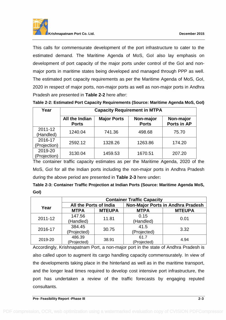
This calls for commensurate development of the port infrastructure to cater to the
estimated demand. The Maritime Agenda of MoS, GoI also lay emphasis on
development of port capacity of the major ports under control of the GoI and non-
major ports in maritime states being developed and managed through PPP as well.
The estimated port capacity requirements as per the Maritime Agenda of MoS, GoI,
2020 in respect of major ports, non-major ports as well as non-major ports in Andhra
Pradesh are presented in Table 2-2 here after:
Table 2-2: Estimated Port Capacity Requirements (Source: Maritime Agenda MoS, GoI)
Year Capacity Requirement in MTPA
All the Indian Ports
Major Ports Non-major Ports
Non-major Ports in AP
2011-12 (Handled)
1240.04 741.36 498.68 75.70
2016-17 (Projection)
2592.12 1328.26 1263.86 174.20
2019-20 (Projection)
3130.04 1459.53 1670.51 207.20
The container traffic capacity estimates as per the Maritime Agenda, 2020 of the
MoS, GoI for all the Indian ports including the non-major ports in Andhra Pradesh
during the above period are presented in Table 2-3 here under:
Table 2-3: Container Traffic Projection at Indian Ports (Source: Maritime Agenda MoS,
GoI)
Year
Container Traffic Capacity
All the Ports of India Non-Major Ports in Andhra Pradesh
MTPA MTEUPA MTPA MTEUPA
2011-12 147.56
(Handled) 11.81
0.15 (Handled)
0.01
2016-17 384.45
(Projected) 30.75
41.5 (Projected)
3.32
2019-20 486.39
(Projected) 38.91
61.7 (Projected)
4.94
Accordingly, Krishnapatnam Port, a non-major port in the state of Andhra Pradesh is
also called upon to augment its cargo handling capacity commensurately. In view of
the developments taking place in the hinterland as well as in the maritime transport,
and the longer lead times required to develop cost intensive port infrastructure, the
port has undertaken a review of the traffic forecasts by engaging reputed
consultants.
PDF compression, OCR, web optimization using a watermarked evaluation copy of CVISION PDFCompressor
Krishnapatnam Port Co. Ltd. December 2015
Pre- Feasibility Report -Phase III 2-4
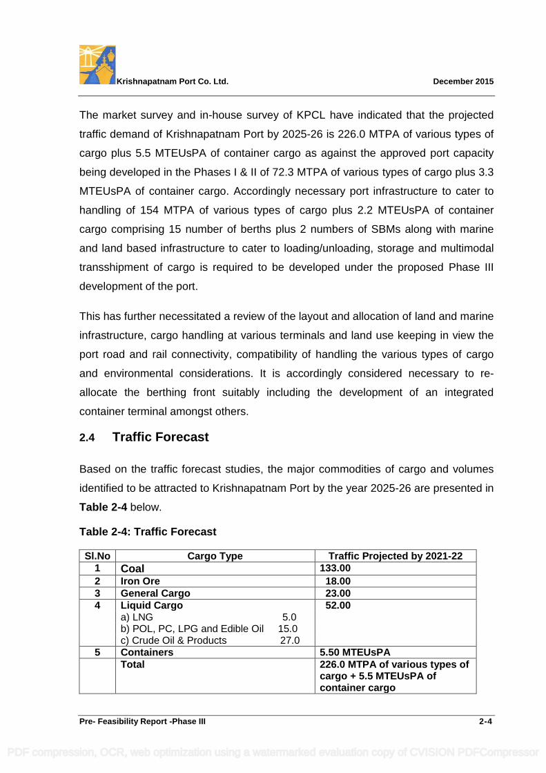
The market survey and in-house survey of KPCL have indicated that the projected
traffic demand of Krishnapatnam Port by 2025-26 is 226.0 MTPA of various types of
cargo plus 5.5 MTEUsPA of container cargo as against the approved port capacity
being developed in the Phases I & II of 72.3 MTPA of various types of cargo plus 3.3
MTEUsPA of container cargo. Accordingly necessary port infrastructure to cater to
handling of 154 MTPA of various types of cargo plus 2.2 MTEUsPA of container
cargo comprising 15 number of berths plus 2 numbers of SBMs along with marine
and land based infrastructure to cater to loading/unloading, storage and multimodal
transshipment of cargo is required to be developed under the proposed Phase III
development of the port.
This has further necessitated a review of the layout and allocation of land and marine
infrastructure, cargo handling at various terminals and land use keeping in view the
port road and rail connectivity, compatibility of handling the various types of cargo
and environmental considerations. It is accordingly considered necessary to re-
allocate the berthing front suitably including the development of an integrated
container terminal amongst others.
2.4 Traffic Forecast
Based on the traffic forecast studies, the major commodities of cargo and volumes
identified to be attracted to Krishnapatnam Port by the year 2025-26 are presented in
Table 2-4 below.
Table 2-4: Traffic Forecast
Sl.No Cargo Type Traffic Projected by 2021-22
1 Coal 133.00
2 Iron Ore 18.00
3 General Cargo 23.00
4 Liquid Cargo 52.00 a) LNG 5.0 b) POL, PC, LPG and Edible Oil 15.0 c) Crude Oil & Products 27.0
5 Containers 5.50 MTEUsPA
Total 226.0 MTPA of various types of cargo + 5.5 MTEUsPA of container cargo
PDF compression, OCR, web optimization using a watermarked evaluation copy of CVISION PDFCompressor
Krishnapatnam Port Co. Ltd. December 2015
Pre- Feasibility Report -Phase III 2-5
2.4.1 Coal
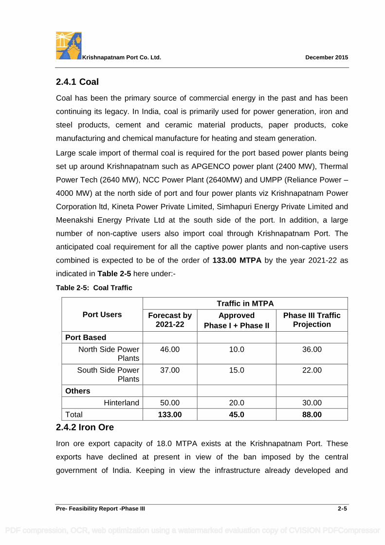
Coal has been the primary source of commercial energy in the past and has been
continuing its legacy. In India, coal is primarily used for power generation, iron and
steel products, cement and ceramic material products, paper products, coke
manufacturing and chemical manufacture for heating and steam generation.
Large scale import of thermal coal is required for the port based power plants being
set up around Krishnapatnam such as APGENCO power plant (2400 MW), Thermal
Power Tech (2640 MW), NCC Power Plant (2640MW) and UMPP (Reliance Power –
4000 MW) at the north side of port and four power plants viz Krishnapatnam Power
Corporation ltd, Kineta Power Private Limited, Simhapuri Energy Private Limited and
Meenakshi Energy Private Ltd at the south side of the port. In addition, a large
number of non-captive users also import coal through Krishnapatnam Port. The
anticipated coal requirement for all the captive power plants and non-captive users
combined is expected to be of the order of 133.00 MTPA by the year 2021-22 as
indicated in Table 2-5 here under:-
Table 2-5: Coal Traffic
Port Users
Traffic in MTPA
Forecast by 2021-22
Approved
Phase I + Phase II
Phase III Traffic Projection
Port Based
North Side Power Plants
46.00 10.0 36.00
South Side Power Plants
37.00 15.0 22.00
Others
Hinterland 50.00 20.0 30.00
Total 133.00 45.0 88.00
2.4.2 Iron Ore
Iron ore export capacity of 18.0 MTPA exists at the Krishnapatnam Port. These
exports have declined at present in view of the ban imposed by the central
government of India. Keeping in view the infrastructure already developed and
PDF compression, OCR, web optimization using a watermarked evaluation copy of CVISION PDFCompressor
Krishnapatnam Port Co. Ltd. December 2015
Pre- Feasibility Report -Phase III 2-6
nearness to the mining areas, Krishnapatnam Port is likely to attract iron ore exports
once the existing ban on iron ore export is lifted by the government.
2.4.3 General Cargo
The general cargo comprises of import/export of fertilizer and fertilizer raw material,
edible oil, lube oil, project cargo, granite, sugar, cement & cement clinker, barytes,
feldspar, food grains, structural steel, pipes, wood and agri-products etc. The details
of major commodities likely to be handled at Krishnapatnam port are as under:-
Fertilizer
India is a developing nation and agriculture is one of the primary contributors to the
economy. The fertilizer demand during the terminal year of the 11th Five Year Plan
has been estimated as 55 million tonnes. As per the planning commission’s report on
fertilizers, the demand supply gap estimated is 11.5 MT by the terminal year of the
eleventh plan, which has to be met by imports. Krishnapatnam Port occupies a
strategic position in the fertilizer imports in view of its location and large warehousing
developed in the port. The port is already handling more than 2.0 MTPA of fertilizer
imports which is likely to increase further up to 4.0 MTPA.
Granite
Granite exports through Krishnapatnam Port are on the increase in view of its
location i.e., nearness to the hinterland. This position will continue during the years
to come too and is expected to reach 3.0 MTPA.
Edible Oil
Already 7 numbers of edible oil refineries are operating near the port. Several more
are also expected to come up in the near future. Edible oil imports through
Krishnapatnam Port are also increasing. It is also likely to continue and further
increase in the coming year’s upto 3.0 MTPA.
Lubricating oil handling is also expected to materialize in the near future through the
Krishnapatnam Port in view of the proposed plant of M/s SHELL of 0.3 MTPA
capacity in the proximity of the port.
PDF compression, OCR, web optimization using a watermarked evaluation copy of CVISION PDFCompressor
Krishnapatnam Port Co. Ltd. December 2015
Pre- Feasibility Report -Phase III 2-7
Other General Cargo
Increased exports of barytes, gypsum, raw sugar, agri and food products, limestone,
clinkers, project cargoes etc., are likely to be attracted to Krishnapatnam Port.
Cement
During 2007-08, the export of cement from India touched the 2.16 million tonnes
mark. However during 2008-09, the cement export experienced a fall, the export
segment of the industry is expected to grow again on account of various
infrastructure projects that are being taken up all over the world. Andhra Pradesh is
the leading cement producer in India with 23 cement plants and about 25 MTPA
installed capacity. Krishnapatnam Port has the advantage to emerge as the port of
preference for cement exports and the likely volume of cement / clinker etc., is
forecast to be about 9.0 MTPA.
Steel Products
India is the 7th largest producer of crude steel in the world. Currently India exports
about 10% of its finished steel production. Additionally, it exports semi-finished steel.
Krishnapatnam Port is the nearest port to the steel plants set up in Karnataka and
those coming up in the Andhra Pradesh. Therefore, Krishnapatnam Port will be
called upon to handle increased exports of iron and steel.
The estimate of total general cargo traffic volume is about 23 MTPA by the year
2025-26as per details furnished in Table 2-6 here under:-
Table 2-6: General Cargo
Name of Cargo
Traffic Forecast (MT)
Capacity of Phase I & Ongoing Phase II
(MT)
Phase III Requirement
(MT)
Fertilizer 4.00 2.65 1.35
Granites 3.00 1.62 1.38
Edible Oil& Lube Oil
3.00 1.71 1.29
Others 13.00 3.00 10.00
Total 23.0 9.00 14.00
PDF compression, OCR, web optimization using a watermarked evaluation copy of CVISION PDFCompressor
Krishnapatnam Port Co. Ltd. December 2015
Pre- Feasibility Report -Phase III 2-8
2.4.4 Liquid Cargo
India’s consumption of petroleum products is only about 1/5th of world’s average per
capita consumption. As per the planning commission’s report, the growth in
consumption is expected to be around 2.6 percent per annum.
India’s demand for LNG/LPG consumption is increasing. The Gas Authority of India
Limited has already taken up the task of developing a supply cum distribution
pipeline all across the country. This will eventually call for developing facilities for
import of LNG/LPG at the ports. As the consumption centers will be spread
throughout the country, more or less all the ports will be required to cater to import
i.e., unloading and storage of this commodity in the near future. Krishnapatnam Port
is already gearing up to handle LNG traffic.
A MoU has been signed with LNG Bharat Private Ltd Hyderabad to handle
5.0 MTPA of liquid natural gas at a dedicated berth. Another proposal for setting up
of a LNG Re Gasification Terminal with associated facilities of 5.0 MTPA capacity
has been finalised with M/s LEPL & Isomeric holdings Sdn. Bhd. (IHSB)
BPCL, IoT Infrastructure & Energy Ltd and Vopak India Ltd have shown a keen
interest to handle POL, petro-chemicals, chemicals and edible oils up to 15.0 MTPA
from the port and need dedicated berths.
Yet another entrepreneur from Kuwait M/s. Al-Kharafi group has shown an interest to
develop a crude oil refinery near the port and is negotiating with GoAP for the
necessary sanctions. They expect to handle 9 MTPA of crude import plus 4.5 MTPA
of POL products export initially which is likely to go up to 18 MTPA and 9.0 MTPA
respectively calling for three SBMs in the open sea. SBMs for crude are likely to
materialize once the plan for setting up of the refinery in the proximity takes shape
along with the commensurate POL export facilities.
Liquid cargo berths for handling of POL, LNG, LPG, petrochemicals, chemicals,
edible oil and SBMs for crude products are expected to generate a traffic of the order
of 15.0 MTPA of POL and Petro chemicals and 10.0 MTPA of LNG at the liquid
cargo berths and at the same time the refinery is expected to generate about 27
MTPA of crude and products handling at the SBMs by the year 2025-26.
PDF compression, OCR, web optimization using a watermarked evaluation copy of CVISION PDFCompressor
Krishnapatnam Port Co. Ltd. December 2015
Pre- Feasibility Report -Phase III 2-9
2.4.5 Container Cargo
With the advent of containerisation, most of the general cargo is being containerized.
The container ports on the eastern coast are located at the extreme ends. Due to the
absence of a container port near the central part of east coast, Central India and
Madhya Pradesh depend on JNPT for their container transports. Even the container
traffic pertaining to states of Karnataka, Andhra Pradesh and Tamilnadu also depend
on JNPT to some extent. The expected shift of container traffic to Krishnapatnam is
assessed as 5.5 MTEUsPA by the year 2025-26 as per Traffic survey of 2013, a
more recent traffic survey estimates realization of this traffic volume by 2025-26.
Container traffic also calls for faster intermodal transport movements. Accordingly,
an integrated container terminal with exclusive container handling berths is proposed
to be developed in the Phase III development with due regard to the port road and
rail connectivity and environmental aspects.
2.4.6 Port Craft Berthing and Repair Needs
With the increasing number of dredgers and harbour craft like tugs, barges, launches
etc., commensurate lay-by and repair facilities by way of berths, wet basins, repair
shops and workshops would be needed. It is therefore considered necessary that the
port infrastructure shall cater to the repair needs by way of lay-by, repair jetties, dry
dock, outfitting jetty and shore facilities like workshops and storage areas.
2.4.7 Coast Guard Jetty
Berthing facility for Coast Guard vessels is also proposed to be developed as
required by them.
2.5 Importance to the Country and the Region
Development or expansion of a port will significantly contribute to the development of
region and the country by way of improved imports and exports through the port
generating revenues to the exchequer, employment generation and improved social
infrastructure.
PDF compression, OCR, web optimization using a watermarked evaluation copy of CVISION PDFCompressor
Krishnapatnam Port Co. Ltd. December 2015
Pre- Feasibility Report -Phase III 2-10
It is considered worthwhile to mention that with the handling of about 21 MTPA, 25.2
MTPA and 40.7 MTPA of cargo through Krishnapatnam Port during the years 2012-
13, 2013-14 and 2014-15, the annual revenue accruals to various departments of the
exchequer is about Rs. 1950 Crores, Rs. 2340 Crores and Rs. 3952 Crores as per
details presented in Table 2-7 here under:
Table 2-7: Revenue Accruals on Account of Krishnapatnam Port
Sl No Government Department Amount in Rs. Crores
2012-13 2013-14 2014-15
1 Customs & Excise Department 640.96 969.65 1,601.76
2 Railways 1056.92 1133.92 2,059.09
3 Central Taxes 227.19 194.11 241.95
Total Annual Revenue accrual to Central Government
1925.07 2297.68 3902.80
4 GoAP by way of lease rent on land and concession fee
22.63 41.36 49.50
Gross Annual Revenue accrual to Exchequer
1947.70 2339.04 3952.30
The revenue accrual to various departments of the Central and state Government
attributable to cargo handling through Krishnapatnam Port is expected to grow with
the increase in the volume of traffic handling. Thus, Krishnapatnam Port will
undoubtedly emerge as a source for earning considerable revenue to the exchequer
i.e., various departments of the Central and State Governments. These revenues get
invested by the government in the needy sectors which in-turn generates
developments in all related sectors.
Further, Krishnapatnam Port development has also been contributing to the
accelerated growth of the region as well as the hinterland. The region is already
witnessing industrial development by way of setting up of a large number of edible oil
refineries, power plants and other industries in the proximity of the port. The
development of Krishnapatnam Port is further contributing to the regional
infrastructure development in all associated sectors viz., industrialization and SEZ’s.
Many more developments in the region are on the anvil.
PDF compression, OCR, web optimization using a watermarked evaluation copy of CVISION PDFCompressor
Krishnapatnam Port Co. Ltd. December 2015
Pre- Feasibility Report -Phase III 2-11
These developments attributable to development to Krishnapatnam Port are
contributing to direct and indirect employment generation, an improvement in the
overall standard of living, development of social infrastructure like housing,
education, health, etc. These positive impacts will continue to take place.
Krishnapatnam Port is also undertaking schemes under its corporate social
responsibility for improvement of the overall living standards in the neighbourhood
villages.
The direct and indirect employment generated due to the port as on date is of the
order of 7,000 numbers and 20,000 numbers, respectively.
2.6 Demand Supply Gap
In respect of the port, demand supply gap shall mean the gap between the port
capacity requirements versus the port capacity availability. By undertaking
substantial reviews of the traffic forecasts carried out through reputed experts and
market surveys, more realistic estimates of traffic demand by the terminal year 2025-
26 have been arrived at as 226.0 MTPA of various types of cargo plus 5.5 MTEUsPA
of container cargo and the demand-supply gap assessed is presented in Table 2-8
here under.
Table 2-8: Demand Supply Gap in Port Capacity for the Terminal Year 2021-22
S.No Cargo
Units in MTPA/MTEUsPA
Traffic Projection
by (2021-22)
Approved Port
capacity of
Phases I & II
Gap in Capacity
1 Coal 133 45.0 88
2
Iron Ore
(Cum-
Multipurpose)
18 18 -
3 General
Cargo 23 9 14
4 Liquid Cargo 52 0.3 51.7
5 Containers 5.50 MTEUsPA 3.30 MTEUsPA 2.2 MTEUsPA
Total
226 MTPA Cargo
+ 5.5 MTEUsPA
of Container
Cargo
72.3 MTPA
Cargo + 3.3
MTEUsPA of
Container Cargo
153.7 or say 154
MTPA
Cargo+2.2
MTEUsPA of
Container cargo
To bridge the demand-supply gap of 154.0 MTPA plus 2.2 MTEUsPA of the port
capacity by 2025-26, Phase III expansion of Krishnapatnam Port is envisaged.
PDF compression, OCR, web optimization using a watermarked evaluation copy of CVISION PDFCompressor

Krishnapatnam Port Co. Ltd. December 2015
Pre- Feasibility Report -Phase III 2-12
2.7 Import Vs Indigenous Production
In as much as a port is not an industry but a facilitator, expansion of the port as
already mentioned catalyzes the regional development through a rapid
industrialization and growth of related infrastructure. Some of the imports serve as
raw materials for various production purposes and increase domestic revenue
accruals of the product thus generated on account of the value addition and also
earn customs duty.
For example: To meet India’s thermal coal and coking coal requirements for the steel
plants and power plants, imports are taking place through various ports in India
including Krishnapatnam Port from countries like Australia, Indonesia and South
Africa. The imports via Krishnapatnam Port augment the production of more
quantities of steel and more MW of power needed for the essential sectors which in
turn contribute to increased indigenous production in relevant sectors. Similarly, the
imports of fertilizers will contribute to increased agricultural yields and production of
essential food grains etc.
The planned Phase III expansion of the Krishnapatnam Port involves procurement of
certain construction equipment and higher capacity cargo handling equipment from
overseas. Other items and technologies required will be mostly indigenous.
2.8 Export Possibility
As mentioned in the foregoing, expansion of Krishnapatnam Port Phase III will
enable increased exports of domestic products like granite, ores, food grains and
agri products, textile, tobacco, machineries etc., as bulk cargo/ general cargo/
container cargo as the case may be.
Port development also catalyzes establishment of SEZs which in turn result in
considerable exports of end products.
The cargo exports through the ports result in considerable amount of Foreign
Exchange earnings to the country.
PDF compression, OCR, web optimization using a watermarked evaluation copy of CVISION PDFCompressor
Krishnapatnam Port Co. Ltd. December 2015
Pre- Feasibility Report -Phase III 2-13
2.9 Domestic / Export Markets
The Krishnapatnam Port, like all other ports of India facilitates development of both
domestic and export markets for the products to be imported or exported by various
port users.
Imports are: Dry Bulk Cargo like Coal, General Cargoes like Fertilizers, Chemicals,
Edible Oil, Lube Oil, Timber, Machineries and Liquid Bulk like LPG, LNG, POL
Products, and Chemicals, etc.
Exports are: Bulk Cargo like Ores, Minerals, General Cargoes like Granite, Textiles,
Agro-Products, Lubricants, Steel, Machineries and Liquid Bulk like POL Products,
Chemicals etc.
2.10 Employment Generation Due to the Project
Port expansion results in direct and indirect employment during the construction and
operation. Owing to the nature of port acting as catalyst in triggering faster
development of the region and hinterland, large scale indirect employment is likely to
be generated in the port based industries and SEZs to be set up in the proximity of
the port and various associated service sectors. The direct and indirect employment
on account of proposed Phase III development of port and associated developments
in the industries shall be of the order of 13500 workers of both skilled and unskilled
categories.
PDF compression, OCR, web optimization using a watermarked evaluation copy of CVISION PDFCompressor
Krishnapatnam Port Co. Ltd. December 2015
Pre- Feasibility Report -Phase III 3-1
3. PROJECT DESCRIPTION
3.1 General
Considering the liberalized Indian economy which is poised for a rapid growth, GoAP
having recognized that ports would play a pivotal role in the emerging buoyancy in
international trade of the Andhra Pradesh coast and in order to facilitate
developments in power sector, industry, agriculture, mineral exploitation etc.,
decided to develop the existing Krishnapatnam minor port into a multipurpose all-
weather, deep water port to handle the EXIM cargo while supporting the socio-
economic growth in the region. Accordingly, the development of Krishnapatnam Port
through PPP mode on BOST basis is being undertaken by M/s. Krishnapatnam Port
Company Ltd in terms of the Concession Agreement entered into during the year
2004 with the GoAP. Krishnapatnam Port will continue to play a catalytic role in
bringing about an industrial revolution in Andhra Pradesh, eastern Karnataka &
northern Tamil Nadu by way of increased exports and imports to / from the hinterland
leading to development of cement and steel industries, thermal power plants and
many allied industries SEZs (special economic zones), logistic parks etc.
The Phase I & II developments of the Krishnapatnam Port cater to authorized port
handling capacity of 72.3 MTPA of various types of cargo plus 3.3 MTEUsPA of
container cargo. The approved facilities developed in 1240 ha (3064 acres) of land
comprise of 17 nos of berths (3 in Phase I and 14 in Phase II - including one berth
for liquid cargo) with necessary harbour protection works i.e., breakwaters, dredging
and reclamation, navigational water ways viz: approach channel, turning circle, dock
basins, navigational aids, harbor crafts etc., shore based infrastructure like cargo
storage areas, roads, railways, bridges, water supply, drainage, operational,
functional, administrative, disaster management-cum-control, welfare and amenity
buildings, cargo handling equipment, conveyors, pipe lines, water supply, electrical
power, area illumination, environmental works like greenbelts, STP, dust
suppression measures etc.
PDF compression, OCR, web optimization using a watermarked evaluation copy of CVISION PDFCompressor
Krishnapatnam Port Co. Ltd. December 2015
Pre- Feasibility Report -Phase III 3-2
The CFO accorded by the APPCB vide order dt 8.6.2009 is being renewed
periodically. Facilities created so far in Phases I & II development of Krishnapatnam
Port are 10 berths and allied marine and shore based infrastructure. Development of
the remaining berths along with associated infrastructure is now under progress.
The 12th Plan Working Group Report on ports of the Planning Commission and the
Maritime Agenda 2020 of the Ministry of Shipping, GoI emphasized the need to
increase the capacity of ports in India including the non-major ports in maritime
states. Accordingly, duly reviewing the traffic forecasts for various types of cargo
likely to be routed through Krishnapatnam Port, it is assessed that by the year
2025-26, there is a need to increase the capacity of the Krishnapatnam Port to
handle 154 MTPA of various types of cargo plus 2.2 MTEUsPA of container cargo.
This is in addition to the approved cargo handling capacity being created at
Krishnapatnam Port in Phase I & Phase II.
3.2 Type of Project Including Interlinked and Interdependent Projects
The present project „Phase III development of Krishnapatnam Port‟ is a port project
catering to development of an additional 154 MTPA capacity to handle various types
of cargo comprising of dry bulk cargo like Coal / Iron ore / limestone / Mines &
Minerals & Other dry bulk cargo, Multipurpose & General break bulk cargo like
Fertilizers and raw materials for manufacture of fertilizer / food grains / sugar / clinker
/ cement / Project cargo / timber & wood / machines/ Iron & steel products / Break
Bulk etc., besides Edible oil, lube oil, liquid & Gas bulk cargo like Crude oil / Naphtha
/ POL / LPG / LNG / Ammonia / Chemicals / Phosphoric Acid / motor spirit /
Kerosene / Aviation fuel / High speed diesel / Lubricating oil / Butane / Propane /
CNG / Furnace Oil / Low sulphure heavy stock / Petro-chemicals, chemicals, crude
etc., plus 2.2 MTEUsPA of container cargo by 2025-26.
PDF compression, OCR, web optimization using a watermarked evaluation copy of CVISION PDFCompressor
Krishnapatnam Port Co. Ltd. December 2015
Pre- Feasibility Report -Phase III 3-3
The project proposals comprise of the development of 20 nos of berths (including
three nos for Liquid cargo), 3 nos of SBMs along with marine and shore-based
multimodal cargo transshipment infrastructure facilities comprising of road / rail
network, bridges, storage areas, water supply, power supply, surface drainage,
mechanical cargo handling equipment, belt conveyors, pipelines, environmental
protection works, operational, functional, administrative, disaster management-cum-
control and amenities building, Shore Protection & Reclamation works besides
development of operation & maintenance infrastructures including 2 nos Dry Dock /
Ship Repair Facilities (one for ports own craft, vessels of Indian Coast Guard and the
other to cater to Naval & commercial vessels) with jetties / quay for berthing to
facilitate repair and outfitting of vessels, port‟s maintenance dredgers, tugs, pilot
launches, mooring boats etc., (Fitting Out Wharf‟s). The development of about 1000
RM of berthing facilities for the various Port Crafts and the Coast Guard vessels
operating from Krishnapatnam Port base as requested by them is also catered to.
This proposal also includes development of an integrated container terminal by
relocating some of the container berths contemplated under the Phase II
development (from along the southern arm to the western dock) keeping in view the
port‟s road and rail connectivity, compatibility of cargo handling and environmental
considerations.
Phase III development of Krishnapatnam Port is an independent project. There are
no interlinked or interdependent projects to be processed simultaneously.
3.3 Location
Krishnapatnam port is located at 140 15‟ 10” N Latitude and 800 08‟ 05” E Longitude
in the Sri Potti Sriramulu Nellore district of Andhra Pradesh and is situated at about
180 km north of Chennai Port on the east coast of India.
PDF compression, OCR, web optimization using a watermarked evaluation copy of CVISION PDFCompressor
Krishnapatnam Port Co. Ltd. December 2015
Pre- Feasibility Report -Phase III 3-4
3.4 Details of Alternate Site
The GoAP embarked on the development of Krishnapatnam Minor Port (operating
since 1825) into deep water, all weather, multi-commodity Port on PPP mode
through BOST basis and awarded the Concession during 2004 to
M/s. Krishnapatnam Port Company Limited. The GoAP have subsequently
sanctioned land to an extent of Ac. 6800 for the development of Krishnapatnam Port
vides its lr. dt. 15-10-2007. 70% of planned infrastructure of Phase-II development of
the Krishnapatnam Port is completed on date and balance infrastructure in progress
is expected to be completed soon. The proposed Phase-III expansion is located
within the limits of the Ac. 6800 of land sanctioned by the GoAP for the
Krishnapatnam Port. Examining alternative sites for the development of
Krishnapatnam Port was considered by GoAP prior to embarking on the
development of the minor port into an all-weather, deep water, multi-commodity port.
As the Krishnapatnam Port has already been established & operational and the
present project being an Expansion of the existing port and will be developed within
the notified port limits, study of site alternatives is not relevant for the proposed
Phase III expansion of the port. However alternative layouts within port have been
examined separately in Chapter -5.
3.5 Size or Magnitude of Operation
The envisaged expansion plan for the Phase III development of Krishnapatnam Port
caters to creation of an additional port capacity to handle 154 MTPA of various types
of cargo plus 2.2 MTEUsPA of container cargo expected to be routed through the
port by the year 2025-26. This is in addition to the cargo handling capacity of 72.3
MTPA of various types of cargo plus 3.3 MTEUsPA of container cargo authorized
during Phase I & II developments of the port. With the expansion of Phase III which
is now envisaged, the total port capacity would cater to handling of 226.00 MTPA of
various types of cargo plus 5.5 MTEUsPA of container cargo.
Based on the vessel sizes expected to call at the port for various types of cargo, the
required marine infrastructure to enable safe navigation and maneuvering of the
vessels and shore based infrastructure including the cargo handling equipment are
contemplated under the Phase III development of the port in a land area of
Ha.1512 (Ac.3736).
PDF compression, OCR, web optimization using a watermarked evaluation copy of CVISION PDFCompressor
Krishnapatnam Port Co. Ltd. December 2015
Pre- Feasibility Report -Phase III 3-5
3.6 Project Description With Process Details
The Phase III development of Krishnapatnam Port is proposed contiguous to the
developments of Phases I & II and to optimally utilize the land earmarked by the
GoAP for the Master Plan development of the port.
The proposed Phase III development of Krishnapatnam Port accordingly comprise of
the following main components:
i. Construction of 20 berths (including 3 nos for handling liquid cargo) plus 3 nos
SBMS to handle the additional cargo forecast.
ii. Procurement, installation and commissioning of cargo handling i.e., loading /
un-loading equipment, cargo transfer systems (i.e., receiving / dispatch) like
conveyors, RO – RO system, yard equipment, pipe lines etc.
iii. Site grading and leveling work.
iv. Development of cargo storage yards, warehouses, Tank Farms and areas for
Free Trade Zones, Port based Industries and Container Freight Station.
v. Construction of a suitably designed rubble mound Shore Protection of about
1300 m long - south of the south breakwater spanning the mid length kink to
the shore. The enclosed area of about Ac.41 is proposed to be utilized for
pipeline corridors for the LNG, LPG, POL & crude oil and to accommodate
related essential control / safety installations and allied infrastructure including
South Breakwater maintenance facility by suitably reclaiming the same with
dredge sand.
vi. Construction of a suitably designed rubble mound “Shore Protection” of about
1050 m long north of the North breakwater spanning between the Round-
Head and the shore. The enclosed area of about Ac.40 is proposed to be
utilized for pipeline corridors for the POL and to accommodate related
essential control / safety installations and allied infrastructure including North
Breakwater maintenance facility by suitably reclaiming the same with dredge
sand.
PDF compression, OCR, web optimization using a watermarked evaluation copy of CVISION PDFCompressor
Krishnapatnam Port Co. Ltd. December 2015
Pre- Feasibility Report -Phase III 3-6
vii. Development of the mangroves in suitable areas as a replacement of the
mangroves falling with in the proposed project area for Phase III development.
The said work will be undertaken duly availing expert advice with a request to
the MoEF to place the onus of development and maintenance of mangroves
on the Project Authority (GoAP) with the entire funding coming from the
Concessionaire.
viii. Training of the Khandaleru creek at a location South-West of the Turning
Circle No.2 by forming a straight cut across existing sand bar and thereafter
reclamation of the meandering north and south arms to develop back space
required for the West Dock berths.
ix. Dredging of 63 million cum for development of waterways and widening /
deepening of existing port waterways including a second lane of the approach
channel and undertaking maintenance dredging of 1.02 million cum per
annum thereafter.
x. Reclamation of the low lying areas to make up the elevation of the existing
land to the proposed working level with 29.0 million cum of dredged material
and disposal of balance 34.0 million cum of dredged material at the approved
disposal ground in the sea, beyond (-)20 m contour.
xi. Augmenting the necessary navigational aids and harbour craft.
xii. Augmenting the In-Plant services like roads and drains, railway lines, flyovers
/ grade separators on important road and rail crossings, bridges, water supply
lines and electrical power supply including power lines, Pipe line corridor for
Oil, LNG, LPG & POL, Conveyor‟s, erection and commissioning of additional
transformers, electrical switchgear instrumentation and area illumination.
xiii. Augmenting the utilities like operational and disaster management cum
control buildings, administrative and functional buildings, electrical
substations, workshops and repair shops, Training & Skill Development
Centers, truck parking areas.
PDF compression, OCR, web optimization using a watermarked evaluation copy of CVISION PDFCompressor
Krishnapatnam Port Co. Ltd. December 2015
Pre- Feasibility Report -Phase III 3-7
xiv. Development of two nos Dry Docks with Fitting out Wharf / berthing and repair
facilities for the port‟s dredgers and harbour craft etc., as well as Naval, Coast
Guard and commercial vessels to ensure uninterrupted and safe port
operation viz., lay-by and repair quay, work shop etc..
xv. Development of jetties about 1000 m long for berthing Ports Crafts and Coast
Guard vessels with suitable back up yard for related facilities on a requested
by them.
xvi. Augmenting the environmental protection works like dust suppression
systems, truck wash areas, STP and greenbelt and Rain Harvest Systems.
xvii. Augmenting the welfare and amenity facilities like rest places, dispensaries,
canteens, safety appliances etc.
xviii. Augmenting of on-line continuous AAQ monitoring equipment and
xix. Development of green belt along the beaches for aesthetic up gradation
3.7 Raw Material Required Along With Estimated Quantity
As the port is not a processing industry, requirement of raw material is not pertinent.
Only construction materials like borrow earth (in addition to use of dredged material
for reclamation) for making up the land to required elevation, stone aggregates for
concrete works, road works and railway works; sand, bricks, stones of various sizes
for breakwater construction etc. would be needed in addition to cement and steel.
Details of the approximate quantity of construction material are given below:
Soil / Gravel – 17.5 million tons
Sand – 4.0 million tons
Stone aggregates – 11.0 million tons
Dredge material – 29.0 million cum
PDF compression, OCR, web optimization using a watermarked evaluation copy of CVISION PDFCompressor
Krishnapatnam Port Co. Ltd. December 2015
Pre- Feasibility Report -Phase III 3-8
3.8 Resource Optimization / Recycling and Reuse Envisaged in
the Project
The low lying areas would be reclaimed to the required elevation by re-cycling
suitable dredged material in order to save the scarce natural resources (borrow
earth). It is estimated that about 29.0 million cum of dredged material would be
utilized for this purpose. Treated effluent from the Sewage Treatment Plants (STP)
will be recycled for dust suppression and greenbelt. Similarly resource optimization
by way of resorting to alternative materials for construction like fly ash gypsum
bricks, aluminum and alloy steel door and window frames etc. would also be
considered.
Rainwater harvesting ponds will be augmented for recharge of the aquifer and to
conserve ground water.
Garland drains, collection pits and guard ponds will be developed for the coal yards
and the run off would be recycled for dust suppression as is being done at present.
3.9 Availability of Water, Its Source, Energy / Power Requirement
3.9.1 Water Requirement
Water supply planned for Phases I & II will be extended to cater to Phase III
development requirement comprising of:
Potable water for consumption of operating personnel
Potable water for ships calling at the port
Water for dust suppression system
Water for greenery
Miscellaneous (Fire Protection)
The water requirement for the port upon completion of the proposed Phase III
development for the above purposes is assessed as 5.0 MLD including 2.5 MLD
envisaged for Phase I & II developments.
PDF compression, OCR, web optimization using a watermarked evaluation copy of CVISION PDFCompressor
Krishnapatnam Port Co. Ltd. December 2015
Pre- Feasibility Report -Phase III 3-9
In terms of the Concession Agreement, GoAP has made a provision of 1 MLD of
water supply from Muthukuru Reservoir for use at Krishnapatnam Port. GoAP also
permitted drawal of 4.0 MLD of water from the Nakkala Kalava irrigation drain. Water
from Muthukuru Reservoir is intended to meet domestic requirements for
consumption. Water from Nakkala Kalava irrigation drain would be used for dust
suppression, green belt, fire-fighting and other allied needs. STP treated effluent
would also be recycled for plantation and dust suppression needs.
3.9.2 Power Requirement
The power required for port activities has been estimated based on the needs of
cargo handling equipment and other operational uses including general consumption
and illumination.
The power requirement which is about 45 MW for the Phases I & II would increase to
130 MW with the proposed development of Phase III. To meet power requirements,
a 132/33 KV substation was built by KPCL in the port limits and APTRANSCO has
committed to power supply of 45 MW, from the grid to the existing substation in the
port limits. Additional power supply for Phase III would also be obtained from the
APTRANSCO‟s power grid. As the port is supporting a number of power plants no
shortage in power is expected.
Standby diesel generators of adequate capacity will be ensured to cater to
emergencies during power failure. Uninterrupted power supply will be ensured for
the IT system.
3.9.3 Quantity of Wastes to be Generated
About 90% of the waste likely to be generated at the port is bio-degradable type like
road sweepings, food waste etc., which is about 900 kg/day would be subjected to
composting for use as manure for green belt within the port.
About 10% of the waste likely to be generated at the port is non-biodegradable like
plastic, shall be collected and disposed through vendors approved by APPCB duly
following the norms. The non-biodegradable waste is about 100 kg/day.
PDF compression, OCR, web optimization using a watermarked evaluation copy of CVISION PDFCompressor
Krishnapatnam Port Co. Ltd. December 2015
Pre- Feasibility Report -Phase III 3-10
Reuse/disposal/management of waste shall be as under:-
Construction wastes and road sweepings, dust, would be used for land fill
Food waste would be recycled as compost
Non-biodegradable (plastic waste, used oils) wastes shall be disposed to
APPCB authorized vendors.
Used batteries shall be disposed by insisting on buy back while procuring.
Cargo spillages shall be collected and cargo shall be returned to storage
yards.
Treated water from STP will be recycled for plantation and dust suppression
purposes and sludge generated from STP shall be used as manure.
3.10 Schematic Representation of the Feasibility Drawing
The layout of the port infrastructure planned under Phase III development of
Krishnapatnam Port along with existing port facilities is shown in
Drawing No. KP / PH-III / PFR / 03.
PDF compression, OCR, web optimization using a watermarked evaluation copy of CVISION PDFCompressor
Krishnapatnam Port Co. Ltd. December 2015
Pre- Feasibility Report -Phase III 4-1
4. SITE ANALYSIS
4.1 Connectivity
Krishnapatnam Port is located in the state of Andhra Pradesh on the east coast of
India. It is about 180 km north of Chennai. Nellore town, the district headquarters of
Sri Potti Sriramulu Nellore district lies at a distance of 25 km north-west and is the
nearest town to the port. Krishnapatnam is connected by a 27 km long district road to
Nellore. Another district road to Venkatachalam connects the national highway NH16
(Old NH 5 from Chennai to Calcutta) at Venkatachalam.
A 23 km long 4 lane dedicated port road connectivity from Krishnapatnam Port to the
National Highway NH 16 (old NH 5) with feasibility to widen to 6 lanes has been
formed by the GoAP in terms of the Concession Agreement.
The main BG trunk railway line connecting Chennai with the east and north passing
through Nellore runs parallel to the coastline about 25 km away from the
Krishnapatnam Port site. The nearest railway station is Venkatachalam.
A 19.4 km long electrified port rail connectivity from Krishnapatnam Port to
Venkatachalam connecting the National Rail Grid is formed by the RVNL as a JV
with GoAP, KPCL and other agencies to cater to traffic to / from the Port. Doubling
work of the Port Rail Connectivity is nearing completion.
The nearest domestic airport is Tirupati at a distance of 120 km from the
Krishnapatnam Port and international airport is at Chennai about 180 km from the
port.
The existing port road and rail connectivity to the national transport network is shown
on Drawing No.KP/PH-III/PFR/04 (TOPOGRAPHIC DETAILS).
4.2 Land form, Land Use and Land Ownership
Krishnapatnam is a port town in Muthukuru Mandal of Nellore District. The port site is
located at the confluence of Khandaleru. The neighbourhood villages to the port are
Krishnapatnam, Gopalapuram on the north, Chalivendra and Narkellapalli,
Pantapalem on the west and Gummala Dibba and Tammenapatnam on the south.
PDF compression, OCR, web optimization using a watermarked evaluation copy of CVISION PDFCompressor
Krishnapatnam Port Co. Ltd. December 2015
Pre- Feasibility Report -Phase III 4-2
GoAP is the owner of the entire land and land for development of Krishnapatnam
Port is being transferred on lease basis by the GoAP to KPCL in terms of the
Concession Agreement. Land to an extent of Ha.2,752 (Ac.6800) including has been
sanctioned for the development of Krishnapatnam Port by the GoAP during 2007.
The Phase I & II developments of the port have been approved in an area of
Ha.1240 (Ac.3064) as per the CRZ and Environmental Clearances accorded by the
MoEF within the limits of the land sanctioned by GoAP for the overall development of
the port. Development of Phase III is now proposed in the balance extent of the land
measuring Ha.1512 ha (Ac.3736).
The area earmarked for Phase III development of the port comprises of lands in
possession of GoAP, forest lands and salt pans. In respect of land measuring
Ha.418 (Ac.1033) belonging to Forest Department and Ha.314 (Ac.775.50)
belonging to Salt Department, requisitions have been placed by the GoAP on the
concerned authorities for transfer of these lands. Action is also being taken by the
GoAP to expedite the process of handing over of these lands on lease basis to
KPCL.
Existing mangroves in and around the port including an extent of Ac.9 as stipulated
in the EC Conditions by MoEF for Phase I development are being protected even
though said area (lying in the salt lands) is yet to be transferred by GoAP to KPCL.
Mangroves to an extent of about Ha.50 (Ac.124) are being developed by KPCL in
terms of the stipulation by MoEF while according EC for Phase II development of the
port. In addition to the above, Mangroves spread over an area of Ha.111.87 present
within the port boundary will also be protected.
4.3 Topography (along with Map)
Nellore district is generally flat and low elevation. Most of the area falls in the
category of slopes less than 2%. It can be broadly divided into two divisions. The
eastern half of the district is fairly flat and comprises of sandy coastal belt extending
all along the district up to 7 km from sea coast. Krishnapatnam Port site which falls in
the eastern half of the district comprise coastal plains, a few ephemeral creeks and
the defunct Buckingham Canal. The port site is located at the confluence of the
Khandaleru creek (Upputeru) with the Bay of Bengal. The port area consists of
coastal plains. The terrain is generally flat. The topography details are shown in
Drawing No.KP/PH-III/PFR/04.
PDF compression, OCR, web optimization using a watermarked evaluation copy of CVISION PDFCompressor
Krishnapatnam Port Co. Ltd. December 2015
Pre- Feasibility Report -Phase III 4-3
4.4 Existing Land use Pattern
Land use of the project area around the Krishnapatnam Port site is predominantly
rural. The immediate vicinity of Krishnapatnam Port, north and south of Khandaleru
creek, is predominantly barren. Details of land use pattern are as under:-
Within Port Boundary
Along the western side of Buckingham Canal, between Upputeru Creek and the
Muthukuru road, the peripheral areas on the north and west have already been
developed for port use during the Phase II. The remaining area is open scrub
with abandoned salt pans and a few degraded mangrove patches. In this area it
is proposed to develop port facilities such as coal stock yards, warehouses, rail,
road, belt conveyor and pipeline facilities without disturbing the mangroves in an
area of about Ac. 9.0 which is required to be protected as per Condition of
Environmental Clearance for Phase I.
The area between Muthukuru Road and Krishnapatnam Village along western
side of Buckingham Canal is open scrub with abandoned salt pans and a few
sparse patches of mangroves. A few road and railway lines have been developed
along the Buckingham Canal as a part of the development of the Phase II and the
balance area is now proposed for development of general cargo storage facilities,
warehouses, truck parking, road & railway lines without disturbing the
mangroves.
On the eastern side of Buckingham Canal, a water body of about Ac.330.67
along with mangrove patches exists and these are being protected and will not be
disturbed while further developed.
Between the water body detailed above and the open coast, the area is barren
vacant land with grass and other vegetation. This area is proposed to be used as
coal storage area supported by roads and conveyor system running parallel to
the coast in continuation of the existing Phase-II port facilities down South
abutting Khandaleru Creek.
About Ac. 1033 of Ipuru Reserve Forest land is located within the limits of the
land sanctioned by GoAP for the development of the Krishnapatnam Port.
PDF compression, OCR, web optimization using a watermarked evaluation copy of CVISION PDFCompressor
Krishnapatnam Port Co. Ltd. December 2015
Pre- Feasibility Report -Phase III 4-4
These are open scrub lands and are designated for the proposed Phase III
development as a container terminal.
The upper stretch of Khandaleru Creek within port boundary bifurcates into two
arms separated by a sand bar. It is proposed to develop this area for construction
of berths taking advantage of the main course of the creek. Some mangrove
patches exist and it is proposed to replace them into the adjacent areas between
the Ipuru Reserve Forest islands.
On the southern side of the Khandaleru Creek the land is a scrub area with some
vegetation comprising of Casuarina and cashew plantation. The area abutting
the creek has already been developed during the Phase-II and further areas
along the western and southern boundary are proposed to be developed as
storage of general cargo, container freight stations, warehouses, Port based
Industries, Free Trade Zones, coal storage, petro chemical storage, LNG storage
& internal roads, railway lines, belt conveyors and pipelines.
The developments of Phase I & II were planned in an area of Ha.1240 (Ac.3064) of
the designated land. The envisaged land use of this area of Phase I & Phase II
developments is for various port‟s operational and other purposes such as
development of berthing front, cargo storage areas, roads, railway lines, drains,
bridges, circulation spaces, greenbelts, services, utilities, amenities, buildings etc.
Outside Port Boundary
There are no national parks, marine parks, sanctuaries, wild life habitats including
biosphere reserves, structures of archaeological importance and heritage sites
within 15 km of the proposed project boundary.
Tammenapatnam Reserve Forest (RF) is located south-west of the project site
and beyond the Khandaleru Creek; Ipuru Reserve Forest is located to the north-
west of the project site. These are mainly open scrublands interspersed with
Casuarina plantations. Further south, Mommidi Reserve Forest (4.5 km),
Kottapatnam Reserve Forest (3.5 km), open scrub with mixed vegetation,
predominantly Casuarina and some cashew plantation are observed. Social
forest comprising Casuarina plantations are also observed.
PDF compression, OCR, web optimization using a watermarked evaluation copy of CVISION PDFCompressor
Krishnapatnam Port Co. Ltd. December 2015
Pre- Feasibility Report -Phase III 4-5
4.4.1 Straightening of Creek
Khandaleru Creek emanating from the upstream area to Krishnapatnam Port joins
the Bay of Bengal near Krishnapatnam Port. Krishnapatnam Port development is
taking place in phases, in and around the existing waterway and the lagoon area
without hindering the flow through the Khandaleru Creek. In the western part of the
lagoon on account of a shoal, the Khandaleru Creek flow is split in two streams with
one meandering waterway towards the south and another meandering waterway
towards the north, circumscribing the sand bar. For development of the port facilities
contemplated under Phase III, it is necessary to form a harbour basin by forming a
straight cut through the island and then reclaiming the meandering north and south
arms to form the back space of berths. The proposal is shown in
Drg. No. KP/PH-III/PFR/05. The existing width and cross section of the water way of
Khandaleru Creek, upstream of the existing proposed straight cut, will be left
undisturbed and by forming the straight cut, the flow will improve facilitating effective
regulation of the creek. Further, as the straight cut is proposed to be utilised as a
dock basin with a dredged level of (-) 17.30 m with berthing front on either side,
deeper water would ensure unhindered discharge of upstream flood water and tidal
exchange all through. The proposal detailed as above is also in corroboration of the
recommendations of the Department of Irrigation, GoAP, who have recently
conducted a survey of all such water bodies / creeks / rivers in the vicinity of the
Krishnapatnam Port.
4.4.2 Development of Mangroves
The proposed Phase III development of the Krishnapatnam Port involves
replacement of some mangroves existing on the upper stretches of Khandaleru
creek between the Ipuru Reserve Forest islands in the project area. The exact extent
will be known upon completion of the HTL, LTL and CRZ Demarcation Survey
undertaken through an agency approved by the MoEF. The CRZ Survey map to be
prepared by such agency will be submitted with the EIA Report. For development of
mangroves in replacement of these mangroves, suitable area would be identified in
the proximity of Krishnapatnam Port, in consultation with experts in this field.
PDF compression, OCR, web optimization using a watermarked evaluation copy of CVISION PDFCompressor
Krishnapatnam Port Co. Ltd. December 2015
Pre- Feasibility Report -Phase III 4-6
Action for replacing of the mangrove existing in the areas designated for the Phase
III development of the port to suitable areas outside the project area will be
undertaken under close liaison with the experts. Suitable funds are earmarked in the
project estimate towards the same. The area of mangrove requiring replacement and
the area outside the project area identified for shifting are shown in
Drawing No./KP/PH-III/PFR/06.
4.4.3 Shore Protection- South of South Breakwater
It is proposed to construct a rubble mound shore protection south of the south
breakwater over a length of about 1300 m and reclaim an area of about Ha. 41.
It is proposed to utilize the same for developing pipeline corridors for the LNG, LPG,
POL & crude oil and to accommodate related essential control / safety installations
and allied infrastructure including breakwater maintenance facility. The proposed
shore protection & area for reclamation is shown in Drg. No. KP/PH-III/PFR/07.
4.4.4 Shore Protection North of North Breakwater
It is proposed to construct a rubble mound shore protection north of the North
breakwater over a length of about 1050 m and reclaim an area of about Ha. 40. It is
proposed to utilize the same for developing pipeline corridors for the LNG, LPG, POL
& crude oil and to accommodate related essential control / safety installations and
allied infrastructure including breakwater maintenance facility. The proposed shore
protection and area for reclamation is shown in Drawing No. KP/PH-III/PFR/08.
4.4.5 Maintaining Existing Drainage
Four ephemeral drains exist in the development area; one of them serving as an
agricultural drain and the rest as drainage path for the defunct salt pans. The
agricultural drain would be diverted and maintained with the proposed culvert CED1.
A culvert “CED 2” is proposed for one drain in the south which is crossing the port
boundary and meeting the Buckingham Canal. The other two local drains would be
reclaimed along with salt pans and the fish ponds except the part of one drain being
maintained with suitable placed pipe lines for tidal exchange to the 9 acres of
mangrove being protected.
PDF compression, OCR, web optimization using a watermarked evaluation copy of CVISION PDFCompressor
Krishnapatnam Port Co. Ltd. December 2015
Pre- Feasibility Report -Phase III 4-7
The low lying land in the development area would be reclaimed for the port use.
Separate drainage system suitable for the proposed land use would be planned and
developed. The drains proposed to be altered and areas to be reclaimed are shown
in Drawing No. KP/PH-III/PFR/14.
4.5 Existing Infrastructure
4.5.1 General
The layout drawing of Phase I & II developments as per CRZ and Environmental
Clearances accorded is presented in Drawing No. KP/PH-III/PFR/01.
4.5.2 Berthing Front
The Phase I & II developments of the port are with 17 berths and other required
marine and shore based infrastructure to cater to 72.3 MTPA of various types of
cargo plus 3.3 MTEUsPA of container cargo. So far 10 berths with corresponding
marine and on shore based infrastructure have been developed and have been put
to effective use. Development of the balance berths and corresponding marine and
onshore infrastructure is in progress.
4.5.3 Marine Infrastructure
Two rubble mound breakwaters, one on the north (1318m) and one on the south
(1624 m) of the approach channel are built to afford protection to the harbor. These
breakwaters are formed using natural stones of various grades as core and
protected with suitably designed concrete armour „KOLOS‟ blocks.
The dimensions and water depths of the approach channel, turning circle and other
navigable water ways cater to the design vessels during the Phase I & Phase II
developments are shown in Table 4-3 here under:
Table 4-3 Design Dredged Depths for Phase I & II Developments
Location Depth below CD (m)
Approach Channel (250m wide) (-)21.6
Turning Circle (600 m diameter) (-)20.7
Berth Area for 1,80,000 DWT Coal vessels (-)18.0
Berth Area for Panamax (80,000 DWT) Coal vessels (-)15.0
Berth area for General Cargo Vessels (-)15.0
Berth area for Container Vessels (-)15.0
PDF compression, OCR, web optimization using a watermarked evaluation copy of CVISION PDFCompressor
Krishnapatnam Port Co. Ltd. December 2015
Pre- Feasibility Report -Phase III 4-8
4.5.4 Navigational Aids
The navigational aids installed during the Phase I & II developments of
Krishnapatnam Port are 25 no‟s of channel marker buoy, 4 no‟s of beacon lights and
2 no‟s of transit lights.
4.5.5 Storage Yards
Cargo storage areas for dry bulk cargo like coal, iron ore and general cargo like
fertilizer, granite, barytes etc are developed as per project contemplations. A
container park area has been partly developed as contemplated. The balance
Container Park areas are proposed to be located during Phase III development in
the area proposed for the development of integrated container terminal in the west
port area. Warehouses for fertilizer, agri-products and cement have also been
developed and further augmentation is proposed in the Phase III development.
Pipelines for edible oil have been laid from the berth to the premises of the users as
required. Mechanizations contemplated are being implemented hand in hand with
availability of land on lease from GoAP. Dust suppression measures are in place to
cater to bulk cargo handling. Balance works are in progress.
The breakup of cargo areas being developed during Phase I & II developments is
presented in Table 4-4 here under:
Table 4-4: Cargo Storage areas being developed under Phase – I & II
Type Of Cargo Area
Storage area for Coal 140 ha (345 acres)
Storage area for Iron Ore 21 ha (52 acres)
Storage area for General cargo & Ware Houses 72 ha (178 acres)
Container Park area 210 ha (520 acres)
Total storage Area 443 ha (1095 acres)
4.5.6 Road / Rail / Pipe line Network
External port road and rail connectivity have been adequately formed by the GoAP
and by the SPV “KRCL” respectively. With this connectivity in place, unhindered
movement of goods to and from the port is taking place without impacting the
existing public infrastructure in the region. Adequate internal roads, railway lines,
pipe lines and conveyors are being developed.
PDF compression, OCR, web optimization using a watermarked evaluation copy of CVISION PDFCompressor
Krishnapatnam Port Co. Ltd. December 2015
Pre- Feasibility Report -Phase III 4-9
Internal road and rail network with bridges commensurate with the project
contemplations developed in the Phase I & II developments of the Krishnapatnam
Port are as under:
4 Lane Roads: 41 km
2 Lane Roads: 15 km
Single Lane Road: 2.5 km
Railway line: 47 km with 15 sidings
Railway Locos (Diesel): 4 No
Road & Rail Bridges : 14 No‟s
4.5.7 Drainage
To cater to runoff, drainage is being developed along the roads and cargo storage
areas. The runoff from cargo storage areas is routed through collection pits and
guard ponds.
Details are as under:
Alongside surface drains : 38 km
Collection pits : 10 no‟s
Guard ponds : 5 no‟s
Domestic sewage from the amenities building is treated at the 300 KLD STP. The
treated effluent is recycled for dust suppression and plantation.
4.5.8 Water Supply
GoAP has sanctioned drawal of 1 MLD of water from Muthukuru reservoir and pipe
line work is on hand. In the meantime i.e., till the pipeline work from Muthukuru
Reservoir is completed by GoAP, domestic water requirement is being procured from
authorized agencies. Storage water tanks have been already built in the port area.
Internal distribution through trucks / pipelines to various consumption locations is in
place. Irrigation authorities of GoAP have also permitted drawal of 4 MLD of water
from the Nakkala Kalava irrigation drain. About 1 MLD of water from this source is
presently being utilized to meet dust suppression and firefighting needs.
PDF compression, OCR, web optimization using a watermarked evaluation copy of CVISION PDFCompressor
Krishnapatnam Port Co. Ltd. December 2015
Pre- Feasibility Report -Phase III 4-10
4.5.9 Other Infrastructure
The following infrastructure as required has been developed to cater to Phase I &
Phase II developments:
Administrative office buildings
Substation and electrical rooms
Disaster management cum control house,
Work shop & loco parking Bay
Operational building like yard master buildings, traffic and trade center etc
Pump houses
Field offices
Gate complex
Container freight station
Bunkering
Firefighting facilities
Warehouses
Custom inspection zone
Documentation center
Amenities blocks
4.6 Shore Line and Littoral Drift
The effects on the littoral drift and shore line changes, on account of construction of
breakwaters and dredging of approach channel of Krishnapatnam Port, have been
studied through numerical model studies by M/S HR Wallingford, UK during 2004
and 2007 for the Phase I & II development of the port. It was reported that “it is
considered that the site may be characterized by erosion on one side of the port
during part of the year, followed by recovery in the second part of the year. Hence
rather than large scale erosion on one side of the port and accretion on the other
side, as would occur at a site with high net transport to either north or south, the
potential erosion of the coast and near shore may recover each year without
intervention”.
After commissioning of the port, the shore line changes have been further monitored
with the help of satellite images through INCOIS (Indian National Center for Ocean
Information Services, Hyderabad) during 2008 to 2010 which confirmed that the
shore line at Krishnapatnam port is fairly stable even after the construction of
breakwaters. Continuous shore line data being collected by Krishnapatnam Port
PDF compression, OCR, web optimization using a watermarked evaluation copy of CVISION PDFCompressor
Krishnapatnam Port Co. Ltd. December 2015
Pre- Feasibility Report -Phase III 4-11
on a monthly basis also indicate that the shore line is accreting except for seasonal
variations. Thus the shore line is largely unaffected by the port development.
The proposed shore protection on the windward of the south & north breakwaters
in shallow depths in the littoral zone is not going to influence the shore line stability
as the full length of breakwaters is catered to in the numerical model study carried
out to ascertain the sediment transport during the earlier phases of the port
development. Further, coast would continue to be an accreting coast as the littoral
drift intercepted by the breakwaters / shore protection works and dredging of
entrance channel would continue to be deposited there.
Hence the Phase III development of the port comprising of development of berths in
the lagoon area, dredging of navigational water ways and shore protection works
adjoining the North and South breakwaters do not have any impact on the shore line.
4.7 Soil
An extensive programme of land and marine boreholes and soil analysis was
undertaken in the 1998 & 2010 in the vicinity of Krishnapatnam port at the area
proposed for development of north & south side berths, conveyor alignment, iron ore
and coal stack yards and offshore location viz., the breakwaters, approach channel
etc.
The area proposed for Phase III development is contiguous to the Phase I & II areas.
It is therefore considered that the soil profile is likely to be similar at the berthing front
proposed for the development of west and northwest docks. At the area proposed for
north and south berths, the borehole shows a 10 to 12 m thick layer of fine silty clay,
sand and sand overlying thick stiff clay having thickness of 10 to 20m. Below the stiff
clay, dense silty sand having thickness varying from 10 to 22m is present. At some
locations bottom silty sand layer is sandwiched with stiff clay layers. Bores are
terminated at a depth of about 55m below G.L / bed level or where hard strata i.e.,
cemented sand is observed whichever is earlier.
All dredging is only in soft materials. As approved in EC the dredged non-cohesive
material is being utilized for reclamation and the balance material is being disposed
of at the approved disposal area in the sea, beyond (-) 20 m contour.
PDF compression, OCR, web optimization using a watermarked evaluation copy of CVISION PDFCompressor
Krishnapatnam Port Co. Ltd. December 2015
Pre- Feasibility Report -Phase III 4-12
4.8 Climatic Data from Secondary Sources
4.8.1 Climate
The region is characterized by hot sub–tropical climate with harsh summers and
annual recurring seasonal monsoon, which divide the year into four seasons as
follows
December to February : Northeast monsoon (wind blows predominantly from
NE direction)
March to May: Pre-Monsoon/Summer season (cyclones occur in May)
June- September : Southwest monsoon (wind blows predominantly from SW
direction)
October & November : Post monsoon(cyclones are most frequent)
4.8.2 Temperature
In May, the mean daily maximum and minimum temperatures are 40.1ºC and 27.2ºC
respectively. During December, the mean daily maximum and minimum
temperatures are 28.7ºC and 20.2ºC respectively. The highest maximum and lowest
minimum temperatures recorded at Krishnapatnam are 47ºC and 14.4ºC
respectively.
4.8.3 Humidity
The climate at Krishnapatnam Port is tropical with average relative humidity of 76%
over the whole year. The air is more humid throughout the year in coastal part than
in the interior parts. The driest part of the year is May to August when the humidity is
on an average varying between 45 and 55%. During September to April, humidity is
around 80% in the morning and 70% in the afternoon.
4.8.4 Visibility
Visibility is good throughout the year at Krishnapatnam Port area. On an average,
visibility is well above 4 km for 320 days in a year.
PDF compression, OCR, web optimization using a watermarked evaluation copy of CVISION PDFCompressor
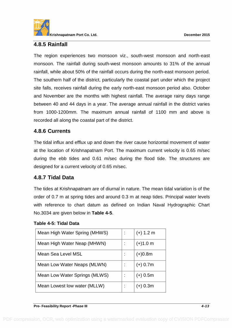
Krishnapatnam Port Co. Ltd. December 2015
Pre- Feasibility Report -Phase III 4-13
4.8.5 Rainfall
The region experiences two monsoon viz., south-west monsoon and north-east
monsoon. The rainfall during south-west monsoon amounts to 31% of the annual
rainfall, while about 50% of the rainfall occurs during the north-east monsoon period.
The southern half of the district, particularly the coastal part under which the project
site falls, receives rainfall during the early north-east monsoon period also. October
and November are the months with highest rainfall. The average rainy days range
between 40 and 44 days in a year. The average annual rainfall in the district varies
from 1000-1200mm. The maximum annual rainfall of 1100 mm and above is
recorded all along the coastal part of the district.
4.8.6 Currents
The tidal influx and efflux up and down the river cause horizontal movement of water
at the location of Krishnapatnam Port. The maximum current velocity is 0.65 m/sec
during the ebb tides and 0.61 m/sec during the flood tide. The structures are
designed for a current velocity of 0.65 m/sec.
4.8.7 Tidal Data
The tides at Krishnapatnam are of diurnal in nature. The mean tidal variation is of the
order of 0.7 m at spring tides and around 0.3 m at neap tides. Principal water levels
with reference to chart datum as defined on Indian Naval Hydrographic Chart
No.3034 are given below in Table 4-5.
Table 4-5: Tidal Data
Mean High Water Spring (MHWS) : (+) 1.2 m
Mean High Water Neap (MHWN) : (+)1.0 m
Mean Sea Level MSL : (+)0.8m
Mean Low Water Neaps (MLWN) : (+) 0.7m
Mean Low Water Springs (MLWS) : (+) 0.5m
Mean Lowest low water (MLLW) : (+) 0.3m
PDF compression, OCR, web optimization using a watermarked evaluation copy of CVISION PDFCompressor
Krishnapatnam Port Co. Ltd. December 2015
Pre- Feasibility Report -Phase III 4-14
4.8.8 Wind
During the south-west monsoon period winds are predominantly from the south-
western direction. During the post monsoon seasons winds are mainly north-western
to north in the mornings and north-eastern to east in the afternoons. During the rest
of the periods winds are mainly from directions between east and south. During
summer and monsoon season wind speed is about 9 km/hr while it about 5 km/hr
during the rest of the period. During north-east monsoon, wind velocity may go up to
50 km/hr and during cyclonic periods the wind speeds may go up to 105 km/hr.
4.8.9 Wave data
As part of numerical model studies carried out for the Phase I & II development of
Krishnapatnam Port, M/s HR Wallingford, UK obtained offshore wave climate from
the UK Meteorology Office for a location north east of Krishnapatnam. The data
shows that the prevailing wave direction is from 135º N – 165 º N sector although
larger waves come from east-north-east. Sea conditions at Krishnapatnam are
usually calm with only slight swell. The offshore wave height of 8.9 m may be
expected to have a return period of 100 years. Such waves will be depth limited in
the inshore area and wave heights in the Krishnapatnam Port area are unlikely to
exceed 5m depending on the local depth. Wave transformation studies were carried
by M/s HRW to arrive at the near shore wave climate for design of the breakwaters
(Hs of 6.0m is adopted for the design of breakwaters) and carrying out harbor
tranquility studies. The offshore wave conditions, as reported by HRW in their report,
where the 50:1 and 1:1 year conditions are derived from the U.K Meteorology Office
model climate and the 1:50 and 1:100 year conditions due to cyclonic conditions are
presented in Table 4-6.
PDF compression, OCR, web optimization using a watermarked evaluation copy of CVISION PDFCompressor
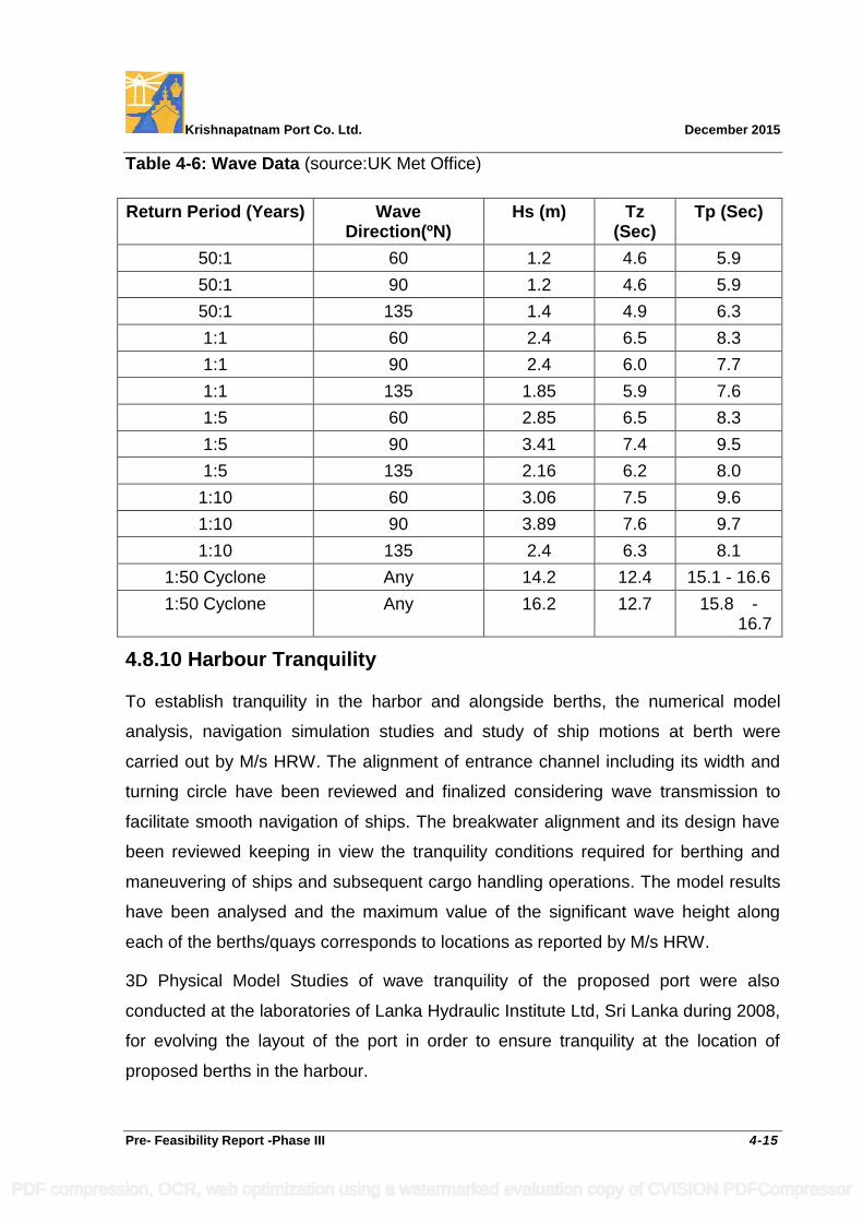
Krishnapatnam Port Co. Ltd. December 2015
Pre- Feasibility Report -Phase III 4-15
Table 4-6: Wave Data (source:UK Met Office)
Return Period (Years) Wave Direction(ºN)
Hs (m) Tz (Sec)
Tp (Sec)
50:1 60 1.2 4.6 5.9
50:1 90 1.2 4.6 5.9
50:1 135 1.4 4.9 6.3
1:1 60 2.4 6.5 8.3
1:1 90 2.4 6.0 7.7
1:1 135 1.85 5.9 7.6
1:5 60 2.85 6.5 8.3
1:5 90 3.41 7.4 9.5
1:5 135 2.16 6.2 8.0
1:10 60 3.06 7.5 9.6
1:10 90 3.89 7.6 9.7
1:10 135 2.4 6.3 8.1
1:50 Cyclone Any 14.2 12.4 15.1 - 16.6
1:50 Cyclone Any 16.2 12.7 15.8 - 16.7
4.8.10 Harbour Tranquility
To establish tranquility in the harbor and alongside berths, the numerical model
analysis, navigation simulation studies and study of ship motions at berth were
carried out by M/s HRW. The alignment of entrance channel including its width and
turning circle have been reviewed and finalized considering wave transmission to
facilitate smooth navigation of ships. The breakwater alignment and its design have
been reviewed keeping in view the tranquility conditions required for berthing and
maneuvering of ships and subsequent cargo handling operations. The model results
have been analysed and the maximum value of the significant wave height along
each of the berths/quays corresponds to locations as reported by M/s HRW.
3D Physical Model Studies of wave tranquility of the proposed port were also
conducted at the laboratories of Lanka Hydraulic Institute Ltd, Sri Lanka during 2008,
for evolving the layout of the port in order to ensure tranquility at the location of
proposed berths in the harbour.
PDF compression, OCR, web optimization using a watermarked evaluation copy of CVISION PDFCompressor
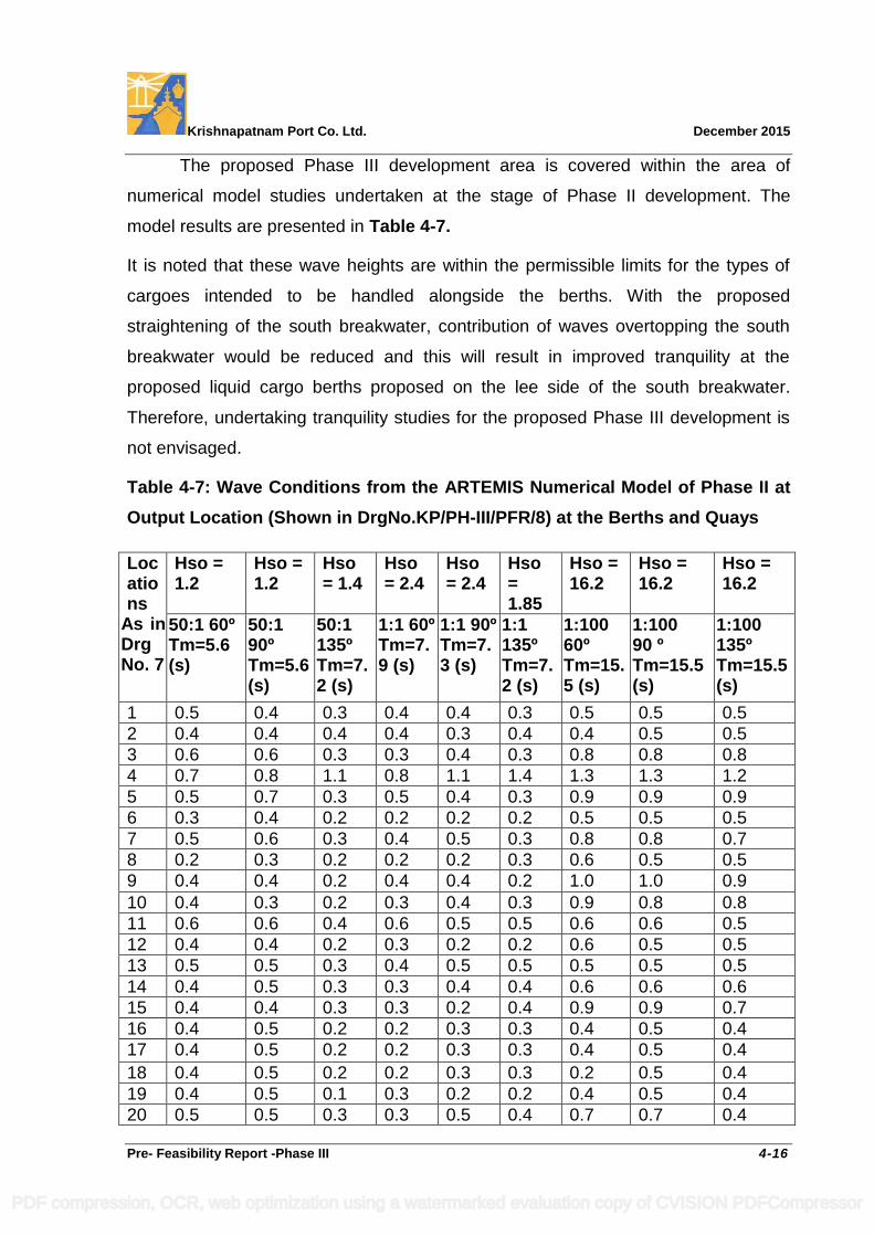
Krishnapatnam Port Co. Ltd. December 2015
Pre- Feasibility Report -Phase III 4-16
The proposed Phase III development area is covered within the area of
numerical model studies undertaken at the stage of Phase II development. The
model results are presented in Table 4-7.
It is noted that these wave heights are within the permissible limits for the types of
cargoes intended to be handled alongside the berths. With the proposed
straightening of the south breakwater, contribution of waves overtopping the south
breakwater would be reduced and this will result in improved tranquility at the
proposed liquid cargo berths proposed on the lee side of the south breakwater.
Therefore, undertaking tranquility studies for the proposed Phase III development is
not envisaged.
Table 4-7: Wave Conditions from the ARTEMIS Numerical Model of Phase II at
Output Location (Shown in DrgNo.KP/PH-III/PFR/8) at the Berths and Quays
Locations
As in Drg No. 7
Hso = 1.2
Hso = 1.2
Hso = 1.4
Hso = 2.4
Hso = 2.4
Hso = 1.85
Hso = 16.2
Hso = 16.2
Hso = 16.2
50:1 60º Tm=5.6 (s)
50:1 90º Tm=5.6 (s)
50:1 135º Tm=7.2 (s)
1:1 60º Tm=7.9 (s)
1:1 90º Tm=7.3 (s)
1:1 135º Tm=7.2 (s)
1:100 60º Tm=15.5 (s)
1:100 90 º Tm=15.5 (s)
1:100 135º Tm=15.5 (s)
1 0.5 0.4 0.3 0.4 0.4 0.3 0.5 0.5 0.5
2 0.4 0.4 0.4 0.4 0.3 0.4 0.4 0.5 0.5
3 0.6 0.6 0.3 0.3 0.4 0.3 0.8 0.8 0.8
4 0.7 0.8 1.1 0.8 1.1 1.4 1.3 1.3 1.2
5 0.5 0.7 0.3 0.5 0.4 0.3 0.9 0.9 0.9
6 0.3 0.4 0.2 0.2 0.2 0.2 0.5 0.5 0.5
7 0.5 0.6 0.3 0.4 0.5 0.3 0.8 0.8 0.7
8 0.2 0.3 0.2 0.2 0.2 0.3 0.6 0.5 0.5
9 0.4 0.4 0.2 0.4 0.4 0.2 1.0 1.0 0.9
10 0.4 0.3 0.2 0.3 0.4 0.3 0.9 0.8 0.8
11 0.6 0.6 0.4 0.6 0.5 0.5 0.6 0.6 0.5
12 0.4 0.4 0.2 0.3 0.2 0.2 0.6 0.5 0.5
13 0.5 0.5 0.3 0.4 0.5 0.5 0.5 0.5 0.5
14 0.4 0.5 0.3 0.3 0.4 0.4 0.6 0.6 0.6
15 0.4 0.4 0.3 0.3 0.2 0.4 0.9 0.9 0.7
16 0.4 0.5 0.2 0.2 0.3 0.3 0.4 0.5 0.4
17 0.4 0.5 0.2 0.2 0.3 0.3 0.4 0.5 0.4
18 0.4 0.5 0.2 0.2 0.3 0.3 0.2 0.5 0.4
19 0.4 0.5 0.1 0.3 0.2 0.2 0.4 0.5 0.4
20 0.5 0.5 0.3 0.3 0.5 0.4 0.7 0.7 0.4
PDF compression, OCR, web optimization using a watermarked evaluation copy of CVISION PDFCompressor
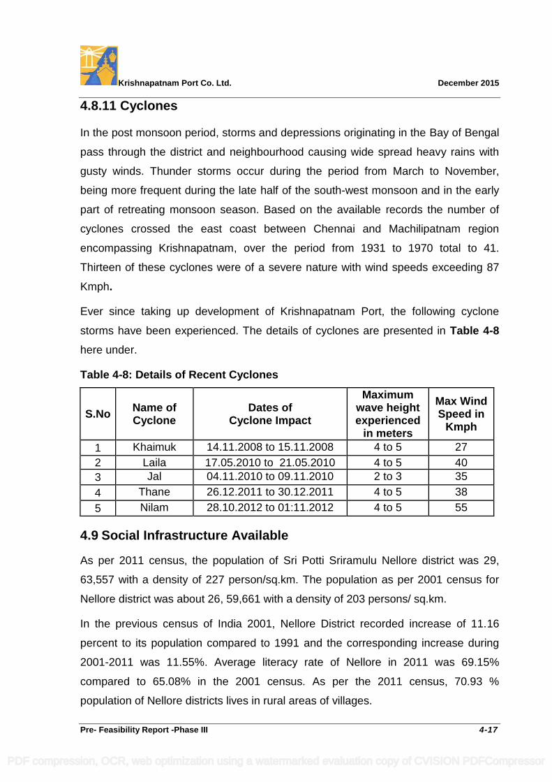
Krishnapatnam Port Co. Ltd. December 2015
Pre- Feasibility Report -Phase III 4-17
4.8.11 Cyclones
In the post monsoon period, storms and depressions originating in the Bay of Bengal
pass through the district and neighbourhood causing wide spread heavy rains with
gusty winds. Thunder storms occur during the period from March to November,
being more frequent during the late half of the south-west monsoon and in the early
part of retreating monsoon season. Based on the available records the number of
cyclones crossed the east coast between Chennai and Machilipatnam region
encompassing Krishnapatnam, over the period from 1931 to 1970 total to 41.
Thirteen of these cyclones were of a severe nature with wind speeds exceeding 87
Kmph.
Ever since taking up development of Krishnapatnam Port, the following cyclone
storms have been experienced. The details of cyclones are presented in Table 4-8
here under.
Table 4-8: Details of Recent Cyclones
S.No Name of Cyclone
Dates of Cyclone Impact
Maximum wave height experienced
in meters
Max Wind Speed in
Kmph
1 Khaimuk 14.11.2008 to 15.11.2008 4 to 5 27
2 Laila 17.05.2010 to 21.05.2010 4 to 5 40
3 Jal 04.11.2010 to 09.11.2010 2 to 3 35
4 Thane 26.12.2011 to 30.12.2011 4 to 5 38
5 Nilam 28.10.2012 to 01:11.2012 4 to 5 55
4.9 Social Infrastructure Available
As per 2011 census, the population of Sri Potti Sriramulu Nellore district was 29,
63,557 with a density of 227 person/sq.km. The population as per 2001 census for
Nellore district was about 26, 59,661 with a density of 203 persons/ sq.km.
In the previous census of India 2001, Nellore District recorded increase of 11.16
percent to its population compared to 1991 and the corresponding increase during
2001-2011 was 11.55%. Average literacy rate of Nellore in 2011 was 69.15%
compared to 65.08% in the 2001 census. As per the 2011 census, 70.93 %
population of Nellore districts lives in rural areas of villages.
PDF compression, OCR, web optimization using a watermarked evaluation copy of CVISION PDFCompressor
Krishnapatnam Port Co. Ltd. December 2015
Pre- Feasibility Report -Phase III 4-18
The major occupation of the households in the district are (i) agricultural labour
(47.67%) followed by (ii) cultivators (21.27%), (iii) service in private and government
departments (9.32%), (iv)Trade and commerce (6.78%), (v) Industrial workers
including salt pan workers (4.07%), (vi)Household industries (2.97%), (vii) Livestock
and fisheries (2.88%), (viii) Transport, storage and communication (2.73%), (ix)
Construction workers (1.91%) and (x) mining and quarrying (0.40%)
Nellore District has 38 large and medium industries in sectors such as sugarcane
crushing, prawn processing, shrimp feed, drugs, pharmaceuticals, dry batteries,
carbon electrodes, beverages, textiles, dairy units, aluminum cans, rubber, mould
caps, iron castings etc. Consequent upon commissioning of the port, edible oil
refineries, thermal power plants, steel plants and other industries are coming up in
addition to manufacturing units and a number of SEZs in the area near the port.
Nellore town is known for its vast spread of educational institutions and professional
colleges. There are a number of hospitals including super-specialty corporate
hospitals. The existing road and drainage system is under improvement. There are
also increased investments in the housing, educational facilities and other social
infrastructure by various individuals and institutions. The overall living standard in the
neighbourhood villages has improved as a result of direct and indirect employment
generation on account of the port and other port based industries and institutions
coming up in the region.
PDF compression, OCR, web optimization using a watermarked evaluation copy of CVISION PDFCompressor
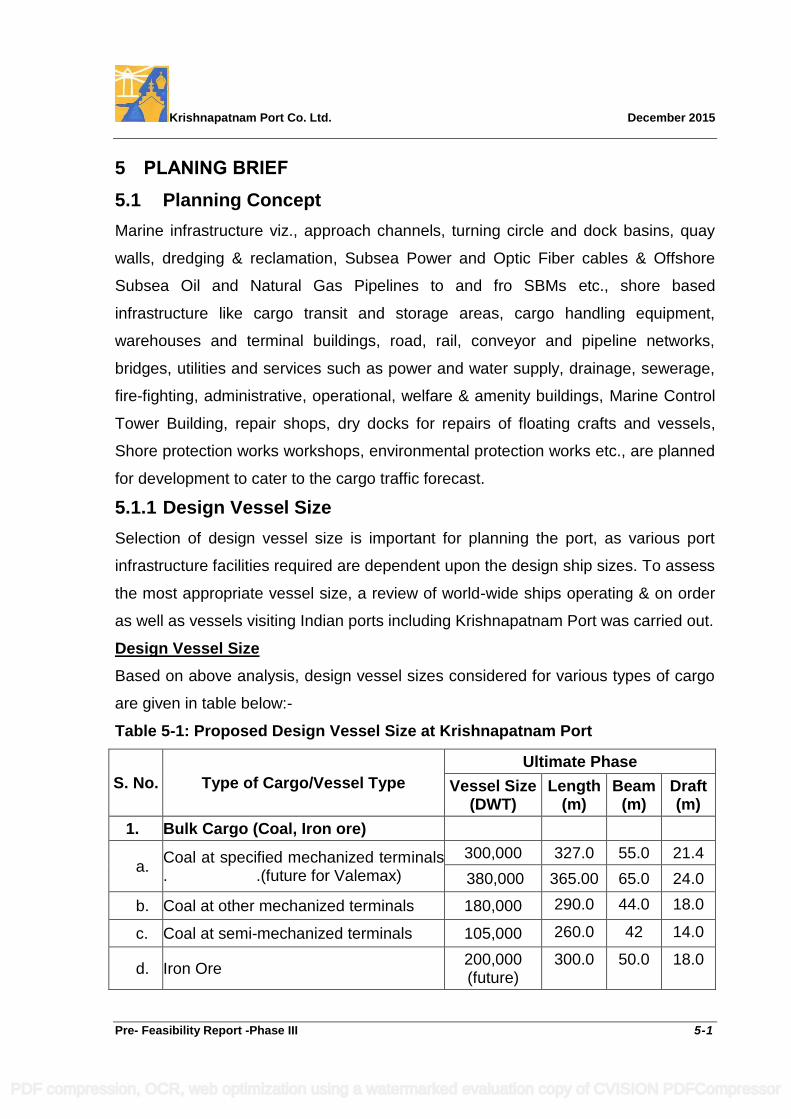
Krishnapatnam Port Co. Ltd. December 2015
Pre- Feasibility Report -Phase III 5-1
5 PLANING BRIEF
5.1 Planning Concept
Marine infrastructure viz., approach channels, turning circle and dock basins, quay
walls, dredging & reclamation, Subsea Power and Optic Fiber cables & Offshore
Subsea Oil and Natural Gas Pipelines to and fro SBMs etc., shore based
infrastructure like cargo transit and storage areas, cargo handling equipment,
warehouses and terminal buildings, road, rail, conveyor and pipeline networks,
bridges, utilities and services such as power and water supply, drainage, sewerage,
fire-fighting, administrative, operational, welfare & amenity buildings, Marine Control
Tower Building, repair shops, dry docks for repairs of floating crafts and vessels,
Shore protection works workshops, environmental protection works etc., are planned
for development to cater to the cargo traffic forecast.
5.1.1 Design Vessel Size
Selection of design vessel size is important for planning the port, as various port
infrastructure facilities required are dependent upon the design ship sizes. To assess
the most appropriate vessel size, a review of world-wide ships operating & on order
as well as vessels visiting Indian ports including Krishnapatnam Port was carried out.
Design Vessel Size
Based on above analysis, design vessel sizes considered for various types of cargo
are given in table below:-
Table 5-1: Proposed Design Vessel Size at Krishnapatnam Port
S. No. Type of Cargo/Vessel Type
Ultimate Phase
Vessel Size (DWT)
Length (m)
Beam (m)
Draft (m)
1. Bulk Cargo (Coal, Iron ore)
a. Coal at specified mechanized terminals . .(future for Valemax)
300,000 327.0 55.0 21.4
380,000 365.00 65.0 24.0
b. Coal at other mechanized terminals 180,000 290.0 44.0 18.0
c. Coal at semi-mechanized terminals 105,000 260.0 42 14.0
d. Iron Ore 200,000 (future)
300.0 50.0 18.0
PDF compression, OCR, web optimization using a watermarked evaluation copy of CVISION PDFCompressor
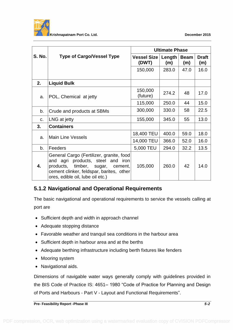
Krishnapatnam Port Co. Ltd. December 2015
Pre- Feasibility Report -Phase III 5-2
S. No. Type of Cargo/Vessel Type
Ultimate Phase
Vessel Size (DWT)
Length (m)
Beam (m)
Draft (m)
150,000 283.0 47.0 16.0
2. Liquid Bulk
a. POL, Chemical at jetty
150,000 (future)
274.2 48 17.0
115,000 250.0 44 15.0
b. Crude and products at SBMs 300,000 330.0 58 22.5
c. LNG at jetty 155,000 345.0 55 13.0
3. Containers
a. Main Line Vessels 18,400 TEU 400.0 59.0 18.0
14,000 TEU 366.0 52.0 16.0
b. Feeders 5,000 TEU 294.0 32.2 13.5
4.
General Cargo (Fertilizer, granite, food and agri products, steel and iron products, timber, sugar, cement, cement clinker, feldspar, barites, other ores, edible oil, lube oil etc.)
105,000 260.0 42 14.0
5.1.2 Navigational and Operational Requirements
The basic navigational and operational requirements to service the vessels calling at
port are
Sufficient depth and width in approach channel
Adequate stopping distance
Favorable weather and tranquil sea conditions in the harbour area
Sufficient depth in harbour area and at the berths
Adequate berthing infrastructure including berth fixtures like fenders
Mooring system
Navigational aids.
Dimensions of navigable water ways generally comply with guidelines provided in
the BIS Code of Practice IS: 4651– 1980 “Code of Practice for Planning and Design
of Ports and Harbours - Part V - Layout and Functional Requirements”.
PDF compression, OCR, web optimization using a watermarked evaluation copy of CVISION PDFCompressor
Krishnapatnam Port Co. Ltd. December 2015
Pre- Feasibility Report -Phase III 5-3
5.1.2.1 Navigable Channel
The dimensions of navigation channel and the parameters like stopping distance,
width at entrance have been arrived at considering an 18,340 TEU capacity
container vessel having the maximum LOA i.e., 400 m LOA. Width and depth of first
lane of the approach channel and diameter of the first turning circle & its depth are
arrived at considering a 380,000 DWT design coal vessel having a maximum beam
and draft of 65 m and 24.0 m respectively. Width and depth of second lane of the
approach channel and diameter of the second turning circle & its depth are arrived at
considering 18,340 TEU & 14,000 TEU design container vessel having a maximum
beam and draft of 59 m and 16 m respectively.
a. Alignment
The approach channel of Krishnapatnam Port is aligned in the E-W direction with a
bearing of 84.50-264.50 up to the turning circle. This is based on navigation
simulation studies carried out in the earlier phases of the port development. The
same alignment of the approach channel would be followed for the Phase III
development too.
b. Channel Depth
Generally, the depth in the channel is determined by:
Vessel‟s loaded draft
Ship‟s motion due to waves, such as pitch, roll and heave
Character of the sea bottom, soft or hard
Wind influence on water level and tidal variations.
As per IS 4651 (Part V), under keel clearance to be provided in the protected
channel is 10% of the draft of the design vessel, 15% in turning circle and 20% in
unsheltered areas. However, considering operational aspects, a 15% under keel
clearance is planned in the inner channel also i.e. from breakwater up to the first
turning circle.
To optimize the dredging quantity, of the two lane approach channel, one lane of 260
m wide is proposed to be dredged eventually to cater to deep draft vessels (upto
380,000 DWT) and in the remaining 230 m width of the second lane is proposed to
be dredged to cater to vessels with draft up to 18 m (18400 TEU container vessel).
PDF compression, OCR, web optimization using a watermarked evaluation copy of CVISION PDFCompressor
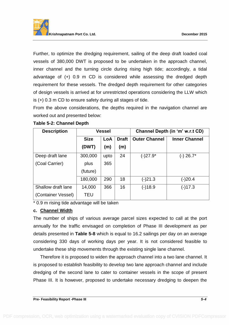
Krishnapatnam Port Co. Ltd. December 2015
Pre- Feasibility Report -Phase III 5-4
Further, to optimize the dredging requirement, sailing of the deep draft loaded coal
vessels of 380,000 DWT is proposed to be undertaken in the approach channel,
inner channel and the turning circle during rising high tide; accordingly, a tidal
advantage of (+) 0.9 m CD is considered while assessing the dredged depth
requirement for these vessels. The dredged depth requirement for other categories
of design vessels is arrived at for unrestricted operations considering the LLW which
is (+) 0.3 m CD to ensure safety during all stages of tide.
From the above considerations, the depths required in the navigation channel are
worked out and presented below:
Table 5-2: Channel Depth
Description Vessel Channel Depth (in ‘m’ w.r.t CD)
Size
(DWT)
LoA
(m)
Draft
(m)
Outer Channel Inner Channel
Deep draft lane
(Coal Carrier)
300,000
plus
(future)
upto
365
24 (-)27.9* (-) 26.7*
180,000 290 18 (-)21.3 (-)20.4
Shallow draft lane
(Container Vessel)
14,000
TEU
366 16 (-)18.9 (-)17.3
* 0.9 m rising tide advantage will be taken
c. Channel Width
The number of ships of various average parcel sizes expected to call at the port
annually for the traffic envisaged on completion of Phase III development as per
details presented in Table 5-8 which is equal to 16.2 sailings per day on an average
considering 330 days of working days per year. It is not considered feasible to
undertake these ship movements through the existing single lane channel.
Therefore it is proposed to widen the approach channel into a two lane channel. It
is proposed to establish feasibility to develop two lane approach channel and include
dredging of the second lane to cater to container vessels in the scope of present
Phase III. It is however, proposed to undertake necessary dredging to deepen the
PDF compression, OCR, web optimization using a watermarked evaluation copy of CVISION PDFCompressor
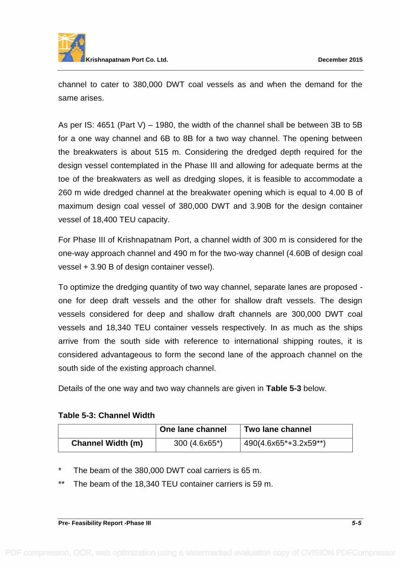
Krishnapatnam Port Co. Ltd. December 2015
Pre- Feasibility Report -Phase III 5-5
channel to cater to 380,000 DWT coal vessels as and when the demand for the
same arises.
As per IS: 4651 (Part V) – 1980, the width of the channel shall be between 3B to 5B
for a one way channel and 6B to 8B for a two way channel. The opening between
the breakwaters is about 515 m. Considering the dredged depth required for the
design vessel contemplated in the Phase III and allowing for adequate berms at the
toe of the breakwaters as well as dredging slopes, it is feasible to accommodate a
260 m wide dredged channel at the breakwater opening which is equal to 4.00 B of
maximum design coal vessel of 380,000 DWT and 3.90B for the design container
vessel of 18,400 TEU capacity.
For Phase III of Krishnapatnam Port, a channel width of 300 m is considered for the
one-way approach channel and 490 m for the two-way channel (4.60B of design coal
vessel + 3.90 B of design container vessel).
To optimize the dredging quantity of two way channel, separate lanes are proposed -
one for deep draft vessels and the other for shallow draft vessels. The design
vessels considered for deep and shallow draft channels are 300,000 DWT coal
vessels and 18,340 TEU container vessels respectively. In as much as the ships
arrive from the south side with reference to international shipping routes, it is
considered advantageous to form the second lane of the approach channel on the
south side of the existing approach channel.
Details of the one way and two way channels are given in Table 5-3 below.
Table 5-3: Channel Width
One lane channel Two lane channel
Channel Width (m) 300 (4.6x65*) 490(4.6x65*+3.2x59**)
* The beam of the 380,000 DWT coal carriers is 65 m.
** The beam of the 18,340 TEU container carriers is 59 m.
PDF compression, OCR, web optimization using a watermarked evaluation copy of CVISION PDFCompressor
Krishnapatnam Port Co. Ltd. December 2015
Pre- Feasibility Report -Phase III 5-6
The existing channel width of 250 m is adequate till vessels likely to call at the port
exceed 180,000 DWT. Further widening and deepening would be undertaken as and
when coal vessels bigger than 180,000 DWT are likely to call at the port.
d. Width of Entrance
The width of entrance between pier heads shall be a minimum of 0.7 to 1.0 times
length of largest design vessel as per IS: 4651 (Part V) – 1980. Accordingly, the
minimum entrance width needed between the breakwaters for navigation of the
380,000 DWT coal vessel of 365 m LoA would be 255 m and that for the 18,340 TEU
capacity container vessels with LoA of 400 m would be 280 m. The entrance width of
250 m proposed between the breakwaters dredged to (-)26.7 m CD to cater to
loaded 380,000 DWT design coal vessel envisaged during Phase-III development
corresponds to 349 m (which is more than 280 m) at (-)17.1 m CD for 18,340 TEU
container vessel. Therefore, the requirement of entrance width is satisfactorily met
with for the design vessels.
5.1.2.2 Stopping Distance
The protected length of the approach channel from the nose of breakwaters up to the
center of turning circle, called stopping distance shall cater to various categories of
vessels contemplated.
As per IS: 4651 (Part V) – 1980, it should be between 3 to 8 times the length of the
largest vessel visiting the port depending upon its condition of loading (i.e., whether
fully laden or ballasted). The stopping distance within the breakwaters available is
1830m. It corresponds to 4.575 times the length of the largest design container
vessel and 5.60 times of largest design coal vessel. This is considered adequate in
as much as adequate tug power would be available during vessel maneuvers in
these areas. Extension of the existing breakwaters is not necessary.
PDF compression, OCR, web optimization using a watermarked evaluation copy of CVISION PDFCompressor
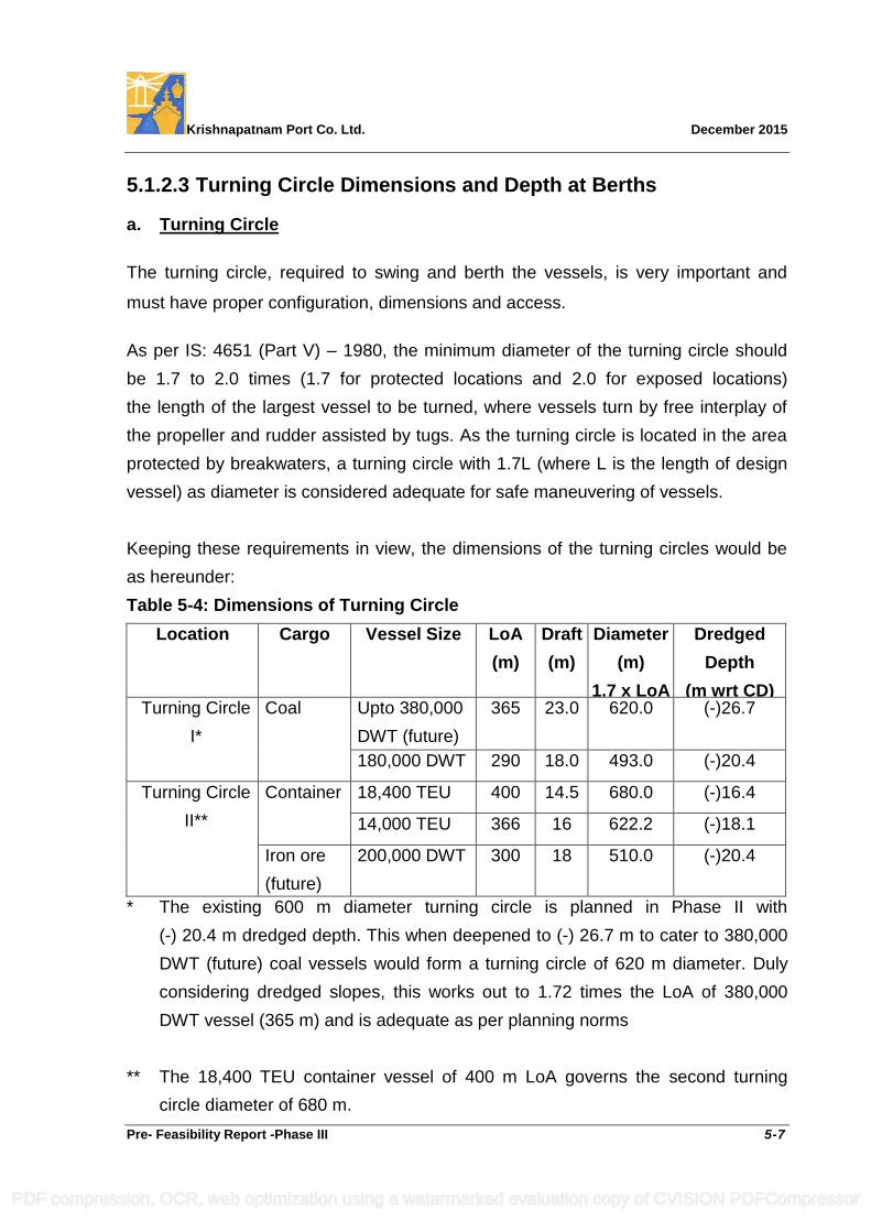
Krishnapatnam Port Co. Ltd. December 2015
Pre- Feasibility Report -Phase III 5-7
5.1.2.3 Turning Circle Dimensions and Depth at Berths
a. Turning Circle
The turning circle, required to swing and berth the vessels, is very important and
must have proper configuration, dimensions and access.
As per IS: 4651 (Part V) – 1980, the minimum diameter of the turning circle should
be 1.7 to 2.0 times (1.7 for protected locations and 2.0 for exposed locations)
the length of the largest vessel to be turned, where vessels turn by free interplay of
the propeller and rudder assisted by tugs. As the turning circle is located in the area
protected by breakwaters, a turning circle with 1.7L (where L is the length of design
vessel) as diameter is considered adequate for safe maneuvering of vessels.
Keeping these requirements in view, the dimensions of the turning circles would be
as hereunder:
Table 5-4: Dimensions of Turning Circle
Location Cargo Vessel Size LoA
(m)
Draft
(m)
Diameter
(m)
1.7 x LoA
Dredged
Depth
(m wrt CD) Turning Circle
I*
Coal Upto 380,000
DWT (future)
365 23.0 620.0 (-)26.7
180,000 DWT 290 18.0 493.0 (-)20.4
Turning Circle
II**
Container 18,400 TEU 400 14.5 680.0 (-)16.4
14,000 TEU 366 16 622.2 (-)18.1
Iron ore
(future)
200,000 DWT 300 18 510.0 (-)20.4
* The existing 600 m diameter turning circle is planned in Phase II with
(-) 20.4 m dredged depth. This when deepened to (-) 26.7 m to cater to 380,000
DWT (future) coal vessels would form a turning circle of 620 m diameter. Duly
considering dredged slopes, this works out to 1.72 times the LoA of 380,000
DWT vessel (365 m) and is adequate as per planning norms
** The 18,400 TEU container vessel of 400 m LoA governs the second turning
circle diameter of 680 m.
PDF compression, OCR, web optimization using a watermarked evaluation copy of CVISION PDFCompressor
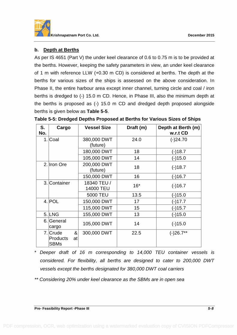
Krishnapatnam Port Co. Ltd. December 2015
Pre- Feasibility Report -Phase III 5-8
b. Depth at Berths
As per IS 4651 (Part V) the under keel clearance of 0.6 to 0.75 m is to be provided at
the berths. However, keeping the safety parameters in view, an under keel clearance
of 1 m with reference LLW (+0.30 m CD) is considered at berths. The depth at the
berths for various sizes of the ships is assessed on the above consideration. In
Phase II, the entire harbour area except inner channel, turning circle and coal / iron
berths is dredged to (-) 15.0 m CD. Hence, in Phase III, also the minimum depth at
the berths is proposed as (-) 15.0 m CD and dredged depth proposed alongside
berths is given below as Table 5-5.
Table 5-5: Dredged Depths Proposed at Berths for Various Sizes of Ships
S. No.
Cargo Vessel Size Draft (m) Depth at Berth (m) w.r.t CD
1. Coal 380,000 DWT (future)
24.0 (-)24.70
180,000 DWT 18 (-)18.7
105,000 DWT 14 (-)15.0
2. Iron Ore 200,000 DWT (future)
18 (-)18.7
150,000 DWT 16 (-)16.7
3. Container 18340 TEU / 14000 TEU
16* (-)16.7
5000 TEU 13.5 (-)15.0
4. POL 150,000 DWT 17 (-)17.7
115,000 DWT 15 (-)15.7
5. LNG 155,000 DWT 13 (-)15.0
6. General cargo
105,000 DWT 14 (-)15.0
7. Crude & Products at SBMs
300,000 DWT 22.5 (-)26.7**
* Deeper draft of 16 m corresponding to 14,000 TEU container vessels is
considered. For flexibility, all berths are designed to cater to 200,000 DWT
vessels except the berths designated for 380,000 DWT coal carriers
** Considering 20% under keel clearance as the SBMs are in open sea
PDF compression, OCR, web optimization using a watermarked evaluation copy of CVISION PDFCompressor
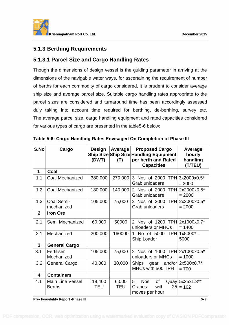
Krishnapatnam Port Co. Ltd. December 2015
Pre- Feasibility Report -Phase III 5-9
5.1.3 Berthing Requirements
5.1.3.1 Parcel Size and Cargo Handling Rates
Though the dimensions of design vessel is the guiding parameter in arriving at the
dimensions of the navigable water ways, for ascertaining the requirement of number
of berths for each commodity of cargo considered, it is prudent to consider average
ship size and average parcel size. Suitable cargo handling rates appropriate to the
parcel sizes are considered and turnaround time has been accordingly assessed
duly taking into account time required for berthing, de-berthing, survey etc.
The average parcel size, cargo handling equipment and rated capacities considered
for various types of cargo are presented in the table5-6 below:
Table 5-6: Cargo Handling Rates Envisaged On Completion of Phase III
S.No Cargo Design Ship Size
(DWT)
Average Ship Size
(T)
Proposed Cargo Handling Equipment per berth and Rated
Capacities
Average hourly
handling (T/TEU)
1 Coal
1.1 Coal Mechanized 380,000 270,000 3 Nos of 2000 TPH Grab unloaders
3x2000x0.5*
= 3000
1.2 Coal Mechanized 180,000 140,000 2 Nos of 2000 TPH Grab unloaders
2x2000x0.5* = 2000
1.3 Coal Semi-mechanized
105,000 75,000 2 Nos of 2000 TPH Grab unloaders
2x2000x0.5* = 2000
2 Iron Ore
2.1 Semi Mechanized 60,000 50000 2 Nos of 1200 TPH unloaders or MHCs
2x1000x0.7* = 1400
2.1 Mechanized 200,000 160000 1 No of 5000 TPH Ship Loader
1x5000* = 5000
3 General Cargo
3.1 Fertiliser Mechanized
105,000 75,000 2 Nos of 1000 TPH unloaders or MHCs
2x1000x0.5* = 1000
3.2 General Cargo 40,000 30,000 Ships gear and/or MHCs with 500 TPH
2x500x0.7*
= 700
4 Containers
4.1 Main Line Vessel Berths
18,400 TEU
6,000 TEU
5 Nos of Quay Cranes with 25 moves per hour
5x25x1.3**
= 162
PDF compression, OCR, web optimization using a watermarked evaluation copy of CVISION PDFCompressor
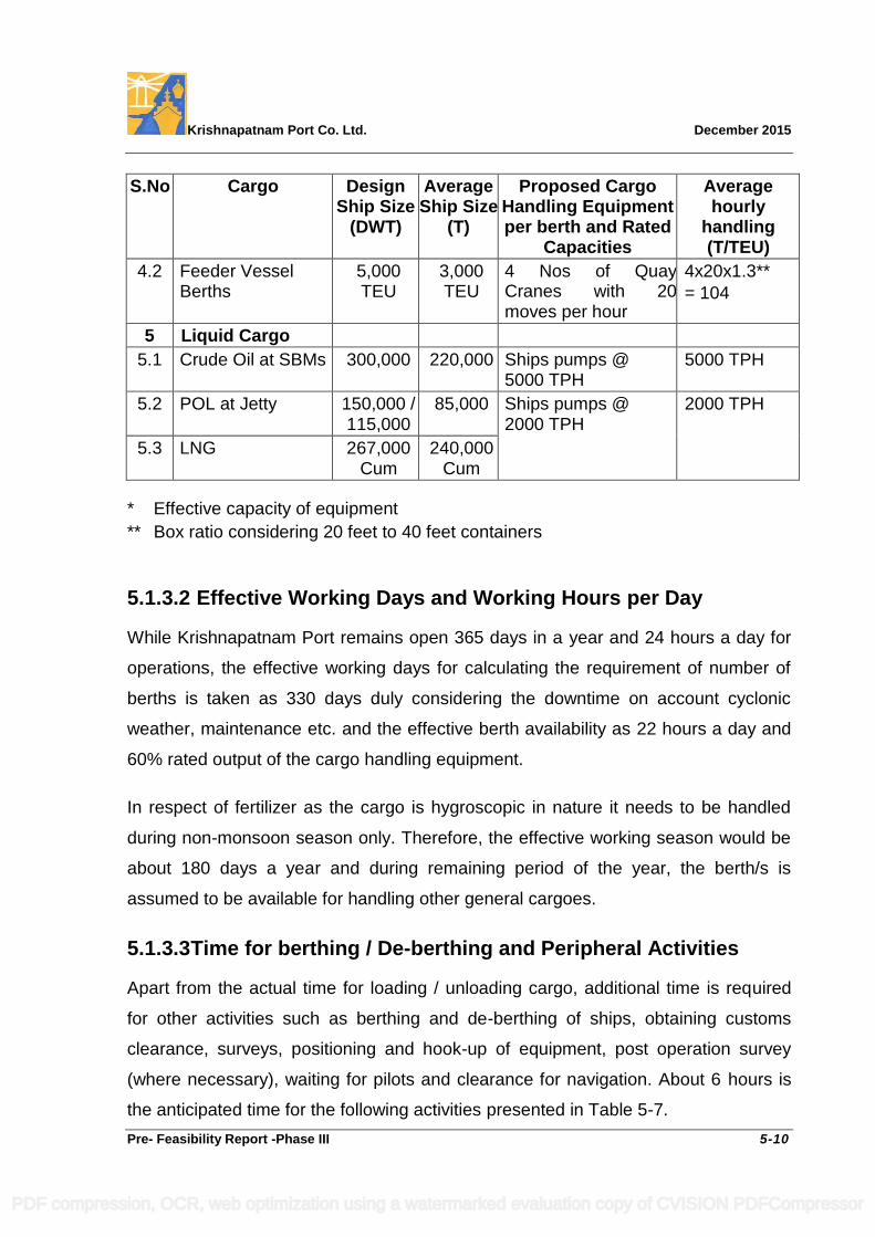
Krishnapatnam Port Co. Ltd. December 2015
Pre- Feasibility Report -Phase III 5-10
S.No Cargo Design Ship Size
(DWT)
Average Ship Size
(T)
Proposed Cargo Handling Equipment per berth and Rated
Capacities
Average hourly
handling (T/TEU)
4.2 Feeder Vessel Berths
5,000 TEU
3,000 TEU
4 Nos of Quay Cranes with 20 moves per hour
4x20x1.3**
= 104
5 Liquid Cargo
5.1 Crude Oil at SBMs 300,000 220,000 Ships pumps @ 5000 TPH
5000 TPH
5.2 POL at Jetty 150,000 / 115,000
85,000 Ships pumps @ 2000 TPH
2000 TPH
5.3 LNG 267,000 Cum
240,000 Cum
* Effective capacity of equipment
** Box ratio considering 20 feet to 40 feet containers
5.1.3.2 Effective Working Days and Working Hours per Day
While Krishnapatnam Port remains open 365 days in a year and 24 hours a day for
operations, the effective working days for calculating the requirement of number of
berths is taken as 330 days duly considering the downtime on account cyclonic
weather, maintenance etc. and the effective berth availability as 22 hours a day and
60% rated output of the cargo handling equipment.
In respect of fertilizer as the cargo is hygroscopic in nature it needs to be handled
during non-monsoon season only. Therefore, the effective working season would be
about 180 days a year and during remaining period of the year, the berth/s is
assumed to be available for handling other general cargoes.
5.1.3.3 Time for berthing / De-berthing and Peripheral Activities
Apart from the actual time for loading / unloading cargo, additional time is required
for other activities such as berthing and de-berthing of ships, obtaining customs
clearance, surveys, positioning and hook-up of equipment, post operation survey
(where necessary), waiting for pilots and clearance for navigation. About 6 hours is
the anticipated time for the following activities presented in Table 5-7.
PDF compression, OCR, web optimization using a watermarked evaluation copy of CVISION PDFCompressor
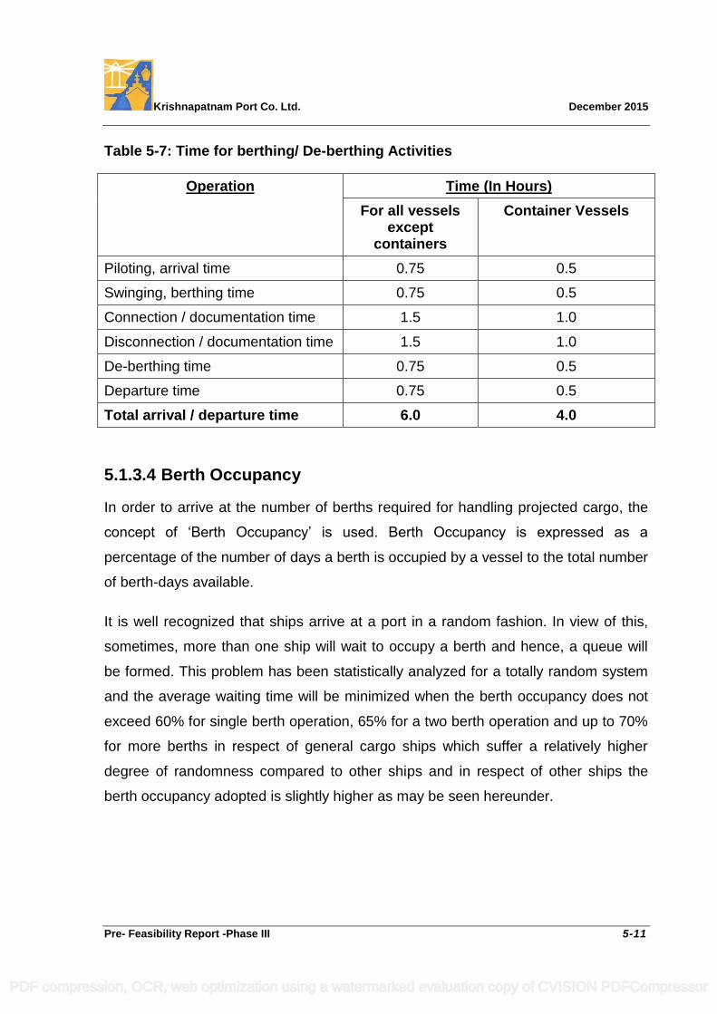
Krishnapatnam Port Co. Ltd. December 2015
Pre- Feasibility Report -Phase III 5-11
Table 5-7: Time for berthing/ De-berthing Activities
Operation Time (In Hours)
For all vessels except
containers
Container Vessels
Piloting, arrival time 0.75 0.5
Swinging, berthing time 0.75 0.5
Connection / documentation time 1.5 1.0
Disconnection / documentation time 1.5 1.0
De-berthing time 0.75 0.5
Departure time 0.75 0.5
Total arrival / departure time 6.0 4.0
5.1.3.4 Berth Occupancy
In order to arrive at the number of berths required for handling projected cargo, the
concept of „Berth Occupancy‟ is used. Berth Occupancy is expressed as a
percentage of the number of days a berth is occupied by a vessel to the total number
of berth-days available.
It is well recognized that ships arrive at a port in a random fashion. In view of this,
sometimes, more than one ship will wait to occupy a berth and hence, a queue will
be formed. This problem has been statistically analyzed for a totally random system
and the average waiting time will be minimized when the berth occupancy does not
exceed 60% for single berth operation, 65% for a two berth operation and up to 70%
for more berths in respect of general cargo ships which suffer a relatively higher
degree of randomness compared to other ships and in respect of other ships the
berth occupancy adopted is slightly higher as may be seen hereunder.
PDF compression, OCR, web optimization using a watermarked evaluation copy of CVISION PDFCompressor
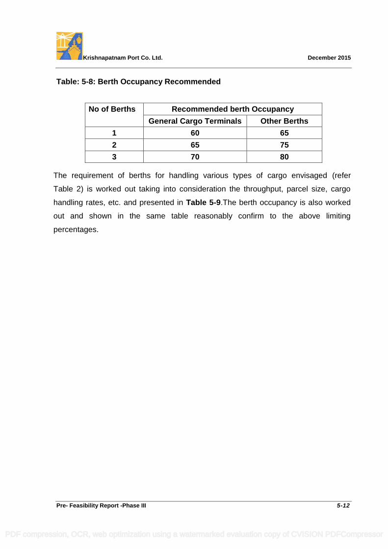
Krishnapatnam Port Co. Ltd. December 2015
Pre- Feasibility Report -Phase III 5-12
Table: 5-8: Berth Occupancy Recommended
No of Berths Recommended berth Occupancy
General Cargo Terminals Other Berths
1 60 65
2 65 75
3 70 80
The requirement of berths for handling various types of cargo envisaged (refer
Table 2) is worked out taking into consideration the throughput, parcel size, cargo
handling rates, etc. and presented in Table 5-9.The berth occupancy is also worked
out and shown in the same table reasonably confirm to the above limiting
percentages.
PDF compression, OCR, web optimization using a watermarked evaluation copy of CVISION PDFCompressor
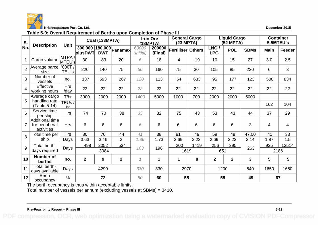
Krishnapatnam Port Co. Ltd. December 2015
Pre-Feasibility Report – Phase III 5-13
Table 5-9: Overall Requirement of Berths upon Completion of Phase III
S. No.
Description Unit Coal (133MPTA) Iron Ore
(18MPTA)
General Cargo (23 MPTA)
Liquid Cargo (52 MPTA)
Container 5.5MTEU’s
300,000 plusDWT
180,000 DWT
Panamax 60000 (Initial)
200000 (Final)
Fertiliser Others LNG / LPG
POL SBMs Main Feeder
1 Cargo volume MTPA / MTEU‟s
30 83 20 6 18 4 19 10 15 27 3.0 2.5
2 Average parcel
size „000T / TEU‟s
220 140 75 50 160 75 30 105 85 220 6 3
3 Number of
vessels no. 137 593 267 120 113 54 633 95 177 123 500 834
4 Effective
working hours Hrs /day
22 22 22 22 22 22 22 22 22 22 22 22
5 Average cargo handling rate (Table 5-14)
T/hr 3000 2000 2000 1400 5000 1000 700 2000 2000 5000
TEUs / hr
162 104
6 Service time
per ship Hrs 74 70 38 35 32 75 43 53 43 44 37 29
7 Additional time for peripheral
activities Hrs 6 6 6 6 6 6 6 6 6 3 4 4
8 Total time per
ship Hrs 80 76 44 41 38 81 49 59 49 47.00 41 33
Days 3.63 3.46 2 1.86 1.73 3.69 2.23 2.69 2.23 2.14 1.87 1.5
9 Total berth-
days required Days
498 2052 534 163 196
200 1419 256 395 263
935 12514
3084 1619 651 2186
10 Number of
berths no. 2 9 2 1 1 1 8 2 2 3 5 5
11 Total berth-
days available Days 4290 330 330 2970 1200 540 1650 1650
12 Berth
occupancy % 72 50 60 55 55 49 67
The berth occupancy is thus within acceptable limits. Total number of vessels per annum (excluding vessels at SBMs) = 3410.
PDF compression, OCR, web optimization using a watermarked evaluation copy of CVISION PDFCompressor

Krishnapatnam Port Co. Ltd. December 2015
Pre- Feasibility Report -Phase III 5-14
5.1.3.5 Requirement of Berths and Quay Length
a. Requirement of berths
Considering the total number of berths arrived in Table 5-9 above and accounting
those being developed under Phase I & II developments, Phase III berth requirement
to handle the envisaged traffic is presented hereunder in Table 5-10:
Table 5-10: Berths Required for Phase III
Type of Cargo Total Berths Required
Number of Berths Sanctioned
Number of Berths to be Developed in Phase III
Phase I Phase II
Coal 13 1 5 7
Iron Ore 1* 1* - -
General cargo 9* 1* 2 6
Container cargo 10 *** - 6*** 4***
Liquid alongside berths (LNG/LPG/POL/Chemicals)
4 - 1 3
Total Berths Excluding SBMs
37 3* 14 ** 20
Liquid at SBMs 3 - - 3
* During Phase I the berthing front approved to cater to Iron Ore, Coal and
General cargo is three berths numbered as N3, N4 and N5.
** During Phase II development 14 berths for various types of cargo are approved
and being developed. These berths are numbered as N1, N2, N6, N7, N8, N9,
NW1, S1, S2, S3, S4, S5, S6 and L1.
*** Keeping in view the advancement in container handling, world over, vis-à-vis
provisions made in the Phase II, requirement of equipment has been reviewed
and catered to in the Phase –III development.
With the 20 berths and 3 SBMs now envisaged in the Phase III, the total berths
available in the port would be 37 (3+14+20) and 3 SBMs proposed in deep waters
outside the breakwaters within the port limits.
PDF compression, OCR, web optimization using a watermarked evaluation copy of CVISION PDFCompressor
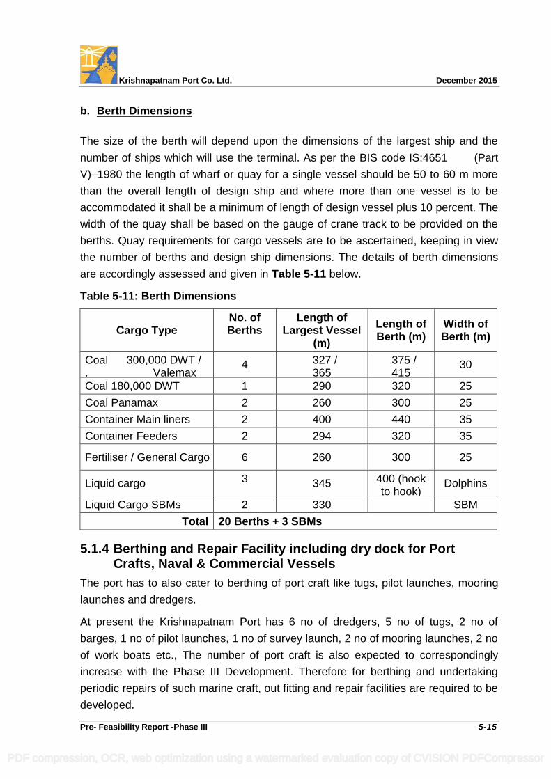
Krishnapatnam Port Co. Ltd. December 2015
Pre- Feasibility Report -Phase III 5-15
b. Berth Dimensions
The size of the berth will depend upon the dimensions of the largest ship and the
number of ships which will use the terminal. As per the BIS code IS:4651 (Part
V)–1980 the length of wharf or quay for a single vessel should be 50 to 60 m more
than the overall length of design ship and where more than one vessel is to be
accommodated it shall be a minimum of length of design vessel plus 10 percent. The
width of the quay shall be based on the gauge of crane track to be provided on the
berths. Quay requirements for cargo vessels are to be ascertained, keeping in view
the number of berths and design ship dimensions. The details of berth dimensions
are accordingly assessed and given in Table 5-11 below.
Table 5-11: Berth Dimensions
Cargo Type No. of Berths
Length of Largest Vessel
(m)
Length of Berth (m)
Width of Berth (m)
Coal 300,000 DWT / . Valemax
4 327 / 365
375 / 415
30
Coal 180,000 DWT 1 290 320 25
Coal Panamax 2 260 300 25
Container Main liners 2 400 440 35
Container Feeders 2 294 320 35
Fertiliser / General Cargo 6 260 300 25
Liquid cargo 3 345 400 (hook to hook)
Dolphins
Liquid Cargo SBMs 2 330
SBM
Total 20 Berths + 3 SBMs
5.1.4 Berthing and Repair Facility including dry dock for Port Crafts, Naval & Commercial Vessels
The port has to also cater to berthing of port craft like tugs, pilot launches, mooring
launches and dredgers.
At present the Krishnapatnam Port has 6 no of dredgers, 5 no of tugs, 2 no of
barges, 1 no of pilot launches, 1 no of survey launch, 2 no of mooring launches, 2 no
of work boats etc., The number of port craft is also expected to correspondingly
increase with the Phase III Development. Therefore for berthing and undertaking
periodic repairs of such marine craft, out fitting and repair facilities are required to be
developed.
PDF compression, OCR, web optimization using a watermarked evaluation copy of CVISION PDFCompressor
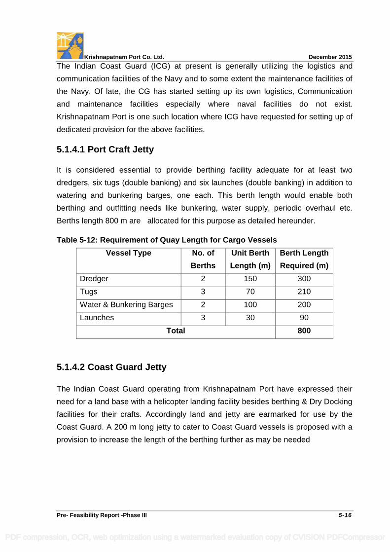
Krishnapatnam Port Co. Ltd. December 2015
Pre- Feasibility Report -Phase III 5-16
The Indian Coast Guard (ICG) at present is generally utilizing the logistics and
communication facilities of the Navy and to some extent the maintenance facilities of
the Navy. Of late, the CG has started setting up its own logistics, Communication
and maintenance facilities especially where naval facilities do not exist.
Krishnapatnam Port is one such location where ICG have requested for setting up of
dedicated provision for the above facilities.
5.1.4.1 Port Craft Jetty
It is considered essential to provide berthing facility adequate for at least two
dredgers, six tugs (double banking) and six launches (double banking) in addition to
watering and bunkering barges, one each. This berth length would enable both
berthing and outfitting needs like bunkering, water supply, periodic overhaul etc.
Berths length 800 m are allocated for this purpose as detailed hereunder.
Table 5-12: Requirement of Quay Length for Cargo Vessels
Vessel Type No. of
Berths
Unit Berth
Length (m)
Berth Length
Required (m)
Dredger 2 150 300
Tugs 3 70 210
Water & Bunkering Barges 2 100 200
Launches 3 30 90
Total 800
5.1.4.2 Coast Guard Jetty
The Indian Coast Guard operating from Krishnapatnam Port have expressed their
need for a land base with a helicopter landing facility besides berthing & Dry Docking
facilities for their crafts. Accordingly land and jetty are earmarked for use by the
Coast Guard. A 200 m long jetty to cater to Coast Guard vessels is proposed with a
provision to increase the length of the berthing further as may be needed
PDF compression, OCR, web optimization using a watermarked evaluation copy of CVISION PDFCompressor
Krishnapatnam Port Co. Ltd. December 2015
Pre- Feasibility Report -Phase III 5-17
5.1.4.3 Dry Docking, Berthing and Repair Facility
The repair facility is required to be adequate to undertake hull repairs and periodical
painting of the hull for the longest port craft viz., Trail hopper Suction dredger
(LoA:114.5 m, Beam:20.6 m and Draft :8.5 m). A repair Dry Dock of 150 m length, 50
m width and 12.0 m depth (with -9.5 m CD sill level at entrance) is proposed for this
purpose. A repair quay length of 200 m is considered necessary to attend to engine
repairs and fitting out purposes. The vessels of the ICG range from 20 m LOA patrol boats to about 100 m long
pollution control vessels. The dry dock of 150 m long and 50 m wide with a 100 m
long Fitting Out Wharf proposed on the South Port to the west of Berth S1 is
considered adequate at present to cater to the maintenance & repair needs of the
ICG vessels as well as ports dredgers and floating craft. This location would be very
close to the proposed location for the Coast Guard facilities and close to the Port
Craft Jetty.
5.1.5 Dry Dock Facility
Ship repair is a location-dependent business. Ships tend to repair close to
their operating routes to avoid expensive deviations, and location in relation to the
available market is of paramount importance. According to industry sources, vessels
from the east coast mostly visit shipyards in Singapore for dry docking, while
dredgers, tugs and cruise boats go to Colombo for repairs due to non-availability of
dry docks in the Indian coast and quick turnaround time. The waiting period for some
of the vessels in Indian docks are said to be over 12 months. Some vessels are
reportedly sailing to China docks due to cheaper tariff.
There is limited effective capacity for ship repair on the east coast of India.
The opportunity for Krishnapatnam Port lies in the general international commercial
sector & the niche international market for the shipyard is the mid-size sector of
Handy to Panamax size plus a local market share of small ships size of up to 150m
length. The proposal is to have a facility of about 325 M long will have marine
facilities, water depths, facilities for vessel launching and docking, dry dock,
PDF compression, OCR, web optimization using a watermarked evaluation copy of CVISION PDFCompressor
Krishnapatnam Port Co. Ltd. December 2015
Pre- Feasibility Report -Phase III 5-18
wet berth requirements, maintenance shop and warehousing facility at the beginning
of the East Quay of the Northern dock and easily accessible from the turning circle.
5.1.6 Cargo Storage Area Requirements
The storage yard acts as a buffer between the ship unloading system and cargo
evacuation system. Storage area must be planned so that a maximum amount of
cargo can be stored in a minimum area. The cargo storages are dependent upon
types of cargo and their dwell time in the port. The receipt and dispatch systems for
various types of cargo should ensure least dwell time of cargo in the port.
5.1.6.1 Storage for Coal
Out of the total 133 MTPA of coal traffic forecast by the end of 2025-26, the
approved capacity for Phases I & II is 45 MTPA and the forecast for Phase III is
88 MTPA. The coal storage capacity required to handle the traffic is assessed as
under:
Out of the total demand for coal imports through Krishnapatnam Port, 83 MTPA is
the assessed demand of the 8 port based users. While it is a normal practice to
provide one month capacity as storage at port, it is proposed to provide storage to
cater to 15 days in the port for these users.
The balance 50 MTPA is the import demand of other users. In this category,
30MTPA is assessed to be handled through mechanized stream while 20 MTPA is
likely to be serviced through semi-mechanized stream.
While normal dwell time of 30 days in the port is adequate in respect of the users
serviced through a mechanized stream, a dwell time of 45 days is considered
minimum for the users to be serviced through semi-mechanized stream.
It is also recalled that during Phases I & II development of the port catering to 45
MTPA of coal imports, storage of 2.9 MT is planned in addition to a 0.25 MT of
temporary storage.
Considering the coal storage developed in Phases I & II, the storage requirement to
be developed in Phase III is arrived at and presented hereunder:
PDF compression, OCR, web optimization using a watermarked evaluation copy of CVISION PDFCompressor
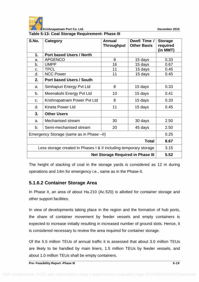
Krishnapatnam Port Co. Ltd. December 2015
Pre- Feasibility Report -Phase III 5-19
Table 5-13: Coal Storage Requirement- Phase III
S.No. Category Annual Throughput
Dwell Time / Other Basis
Storage required (in MMT)
1. Port based Users / North
a. APGENCO 8 15 days 0.33
b. UMPP 16 15 days 0.67
c. TPCL 11 15 days 0.45
d. NCC Power 11 15 days 0.45
2. Port based Users / South
a. Simhapuri Energy Pvt Ltd 8 15 days 0.33
b. Meenakshi Energy Pvt Ltd 10 15 days 0.41
c. Krishnapatnam Power Pvt Ltd 8 15 days 0.33
d. Kineta Power Ltd 11 15 days 0.45
3. Other Users
a. Mechanised stream 30 30 days 2.50
b. Semi-mechanised stream 20 45 days 2.50
Emergency Storage (same as in Phase –II) 0.25
Total 8.67
Less storage created in Phases I & II including temporary storage 3.15
Net Storage Required in Phase III 5.52
The height of stacking of coal in the storage yards is considered as 12 m during
operations and 14m for emergency i.e., same as in the Phase-II.
5.1.6.2 Container Storage Area
In Phase II, an area of about Ha.210 (Ac.520) is allotted for container storage and
other support facilities.
In view of developments taking place in the region and the formation of hub ports,
the share of container movement by feeder vessels and empty containers is
expected to increase initially resulting in increased number of ground slots. Hence, it
is considered necessary to review the area required for container storage.
Of the 5.5 million TEUs of annual traffic it is assessed that about 3.0 million TEUs
are likely to be handled by main liners, 1.5 million TEUs by feeder vessels, and
about 1.0 million TEUs shall be empty containers.
PDF compression, OCR, web optimization using a watermarked evaluation copy of CVISION PDFCompressor
Krishnapatnam Port Co. Ltd. December 2015
Pre- Feasibility Report -Phase III 5-20
Duly reckoning the above, the average dwell time of containers is assessed as
8 days and the required storage capacity of the container yard works out to 120,000
TEUs, excluding a reserve.
The containers will be stacked 3-4 high. The area requirement per TEU is 10 m2 as
per UNCTAD norms with 3 high stacking. The empties would be handled in a
separate zone within the container yard by reach stackers and the area requirement
per TEU is about 20 m2 as per UNCTAD norms. The weighted average area
requirement per TEU works out to about 15 m2.
Considering the ratio of average to maximum stacking height as 0.60 and 30%
reserve, the container park area for 120,000 TEUs works out to be Ha.385 (Ac.945).
As per norms, an area of Ha.24 (Ac.60) is also provided for the purpose of container
handling related activities.
Provision of about Ha.60 (Ac.150) is made for container freight stations assuming
that 30% of container traffic would use the CFS facility at the port.
Thus the total area assessed for container handling related activities is Ha.469
(Ac.1160). Duly reckoning the Ha.210 (Ac.520) considered during Phase I, the land
requirement of Ha.259 (Ac.640) for Phase-III development is catered to in the land
allocation for container handling and above mentioned related purposes.
5.1.6.3 General Cargo
Fertiliser being hygroscopic in nature will be stored in warehouses.
Other general cargo comprises of barytes, clinker, gypsum, rock phosphate, project
cargo, agriculture products, limestone, cement, steel products, edible oil and lube oil.
Barytes, clinker, gypsum, rock phosphate, project cargo, lime stone and steel
products will be stored in open areas. Agricultural produce and cement will be stored
in warehouses.
Fertiliser and agricultural products are seasonal cargo and are handled for 6 months
in a year. The stacking height and dwell time considered for assessing the storage
area for fertiliser and agricultural products are 3.5 m and 60 days, respectively.
PDF compression, OCR, web optimization using a watermarked evaluation copy of CVISION PDFCompressor
Krishnapatnam Port Co. Ltd. December 2015
Pre- Feasibility Report -Phase III 5-21
The stacking height and dwell time considered for assessing the storage area for
other general cargo are 1 m and 30 days, respectively.
Edible oil and lube oil are directly pumped to users through pipelines and do not
require major storage in the port.
Based on requests being received for development of cement clinker units and
bitumen blending and storage etc., a land area of Ha.12 (Ac.30) is allotted.
5.1.6.4 Liquid Cargo
Liquid cargoes to be handled at Krishnapatnam Port are LNG, POL products and
crude oil. Crude Oil will be directly pumped from SBMs to the refineries through
pipelines. LNG / POL will be pumped through pipelines from jetty to the storage area.
While pipelines being laid from the liquid berth during Phase-II are proposed to be
routed on trestles from jetty up to the south breakwater and on pipe supports to be
built on rock fill towards lee side of the south breakwater. It is proposed to
beneficially utilize the accretion noticed on the sea side of breakwaters near the
coast by providing suitably designed protection works capable of withstanding the
incident waves. In respect of liquid berths proposed during this Phase-III
development, the pipelines are proposed to be laid on trestles from berths up to the
respective breakwaters and thereafter on land proposed to be reclaimed between
the existing breakwater and proposed shore protection. It is also proposed to
accommodate related essential control / safety installations and allied infrastructure
including breakwater maintenance facility on this reclaimed land which is beyond the
safety zone for the liquid cargo berths.
Storage will provided for LNG and POL products in suitable tanks. Considering
safety clearances, a total area of Ha.186 is provided for liquid cargo storage to cater
to the anticipated liquid cargo handling of 52 MTPA.
Two island type platforms connected with approach trestles are proposed to be
developed as tank farms for LNG, based on trade demand.
PDF compression, OCR, web optimization using a watermarked evaluation copy of CVISION PDFCompressor
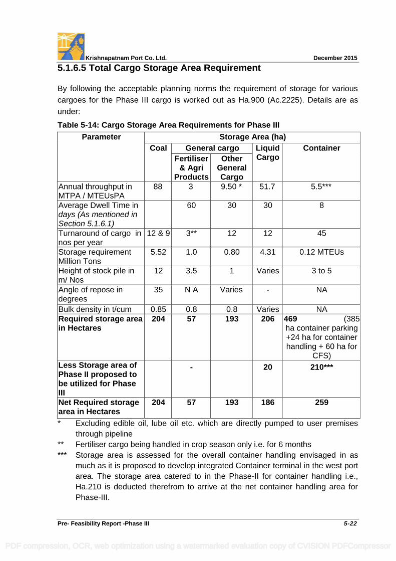
Krishnapatnam Port Co. Ltd. December 2015
Pre- Feasibility Report -Phase III 5-22
5.1.6.5 Total Cargo Storage Area Requirement
By following the acceptable planning norms the requirement of storage for various
cargoes for the Phase III cargo is worked out as Ha.900 (Ac.2225). Details are as
under:
Table 5-14: Cargo Storage Area Requirements for Phase III
Parameter Storage Area (ha)
Coal General cargo Liquid Cargo
Container
Fertiliser & Agri
Products
Other General Cargo
Annual throughput in MTPA / MTEUsPA
88
3 9.50 * 51.7 5.5***
Average Dwell Time in days (As mentioned in Section 5.1.6.1)
60 30 30 8
Turnaround of cargo in nos per year
12 & 9 3** 12 12 45
Storage requirement Million Tons
5.52 1.0 0.80 4.31 0.12 MTEUs
Height of stock pile in m/ Nos
12 3.5 1 Varies 3 to 5
Angle of repose in degrees
35 N A Varies - NA
Bulk density in t/cum 0.85 0.8 0.8 Varies NA
Required storage area in Hectares
204
57
193
206 469 (385 ha container parking +24 ha for container handling + 60 ha for
CFS)
Less Storage area of Phase II proposed to be utilized for Phase III
- 20 210***
Net Required storage area in Hectares
204 57 193 186 259
* Excluding edible oil, lube oil etc. which are directly pumped to user premises
through pipeline
** Fertiliser cargo being handled in crop season only i.e. for 6 months
*** Storage area is assessed for the overall container handling envisaged in as
much as it is proposed to develop integrated Container terminal in the west port
area. The storage area catered to in the Phase-II for container handling i.e.,
Ha.210 is deducted therefrom to arrive at the net container handling area for
Phase-III.
PDF compression, OCR, web optimization using a watermarked evaluation copy of CVISION PDFCompressor
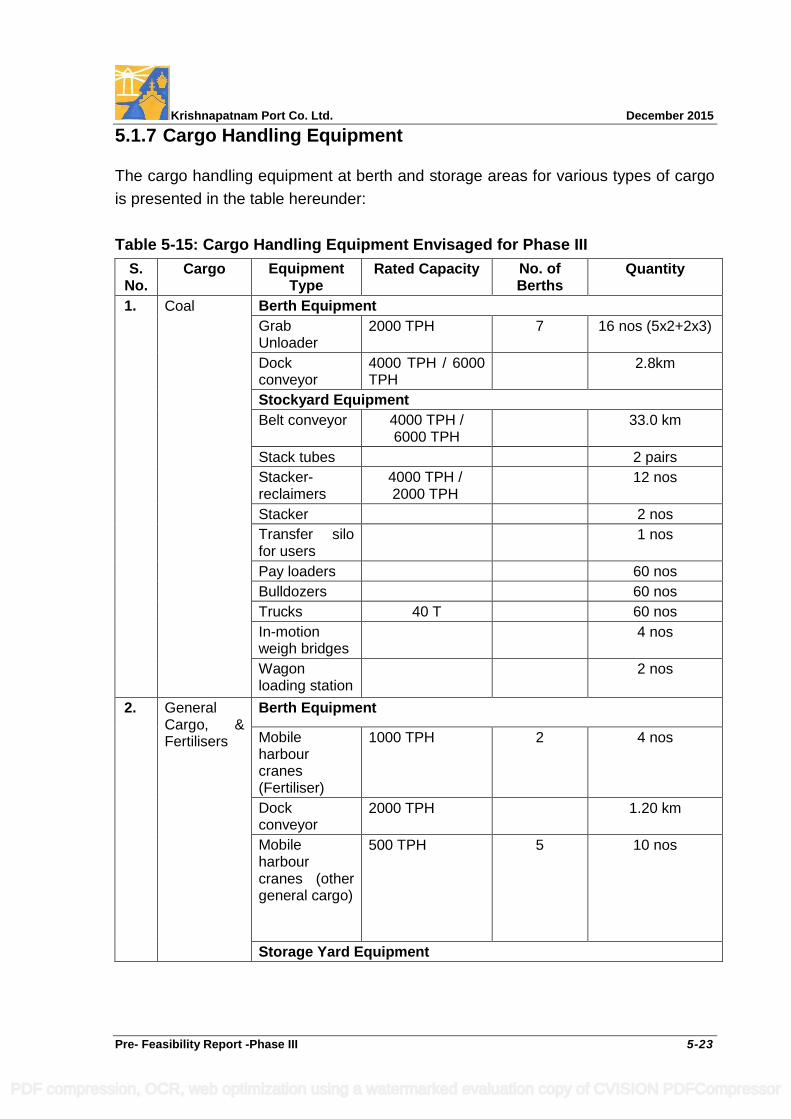
Krishnapatnam Port Co. Ltd. December 2015
Pre- Feasibility Report -Phase III 5-23
5.1.7 Cargo Handling Equipment
The cargo handling equipment at berth and storage areas for various types of cargo
is presented in the table hereunder:
Table 5-15: Cargo Handling Equipment Envisaged for Phase III
S. No.
Cargo Equipment Type
Rated Capacity No. of Berths
Quantity
1. Coal Berth Equipment
Grab Unloader
2000 TPH 7 16 nos (5x2+2x3)
Dock conveyor
4000 TPH / 6000 TPH
2.8km
Stockyard Equipment
Belt conveyor 4000 TPH / 6000 TPH
33.0 km
Stack tubes 2 pairs
Stacker-reclaimers
4000 TPH / 2000 TPH
12 nos
Stacker 2 nos
Transfer silo for users
1 nos
Pay loaders 60 nos
Bulldozers 60 nos
Trucks 40 T 60 nos
In-motion weigh bridges
4 nos
Wagon loading station
2 nos
2. General Cargo, & Fertilisers
Berth Equipment
Mobile harbour cranes (Fertiliser)
1000 TPH 2 4 nos
Dock conveyor
2000 TPH 1.20 km
Mobile harbour cranes (other general cargo)
500 TPH 5 10 nos
Storage Yard Equipment
PDF compression, OCR, web optimization using a watermarked evaluation copy of CVISION PDFCompressor
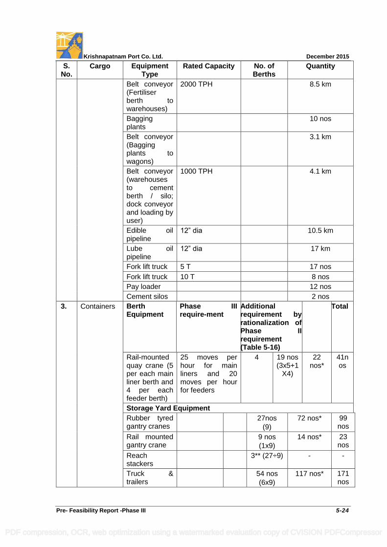
Krishnapatnam Port Co. Ltd. December 2015
Pre- Feasibility Report -Phase III 5-24
S. No.
Cargo Equipment Type
Rated Capacity No. of Berths
Quantity
Belt conveyor (Fertiliser berth to warehouses)
2000 TPH 8.5 km
Bagging plants
10 nos
Belt conveyor (Bagging plants to wagons)
3.1 km
Belt conveyor (warehouses to cement berth / silo; dock conveyor and loading by user)
1000 TPH 4.1 km
Edible oil pipeline
12” dia 10.5 km
Lube oil pipeline
12” dia 17 km
Fork lift truck 5 T 17 nos
Fork lift truck 10 T 8 nos
Pay loader 12 nos
Cement silos 2 nos
3. Containers Berth Equipment
Phase III require-ment
Additional requirement by rationalization of Phase II requirement (Table 5-16)
Total
Rail-mounted quay crane (5 per each main liner berth and 4 per each feeder berth)
25 moves per hour for main liners and 20 moves per hour for feeders
4
19 nos (3x5+1
X4)
22 nos*
41nos
Storage Yard Equipment
Rubber tyred gantry cranes
27nos
(9)
72 nos* 99 nos
Rail mounted gantry crane
9 nos
(1x9)
14 nos* 23 nos
Reach stackers
3** (27÷9) - -
Truck & trailers
54 nos
(6x9)
117 nos* 171 nos
PDF compression, OCR, web optimization using a watermarked evaluation copy of CVISION PDFCompressor
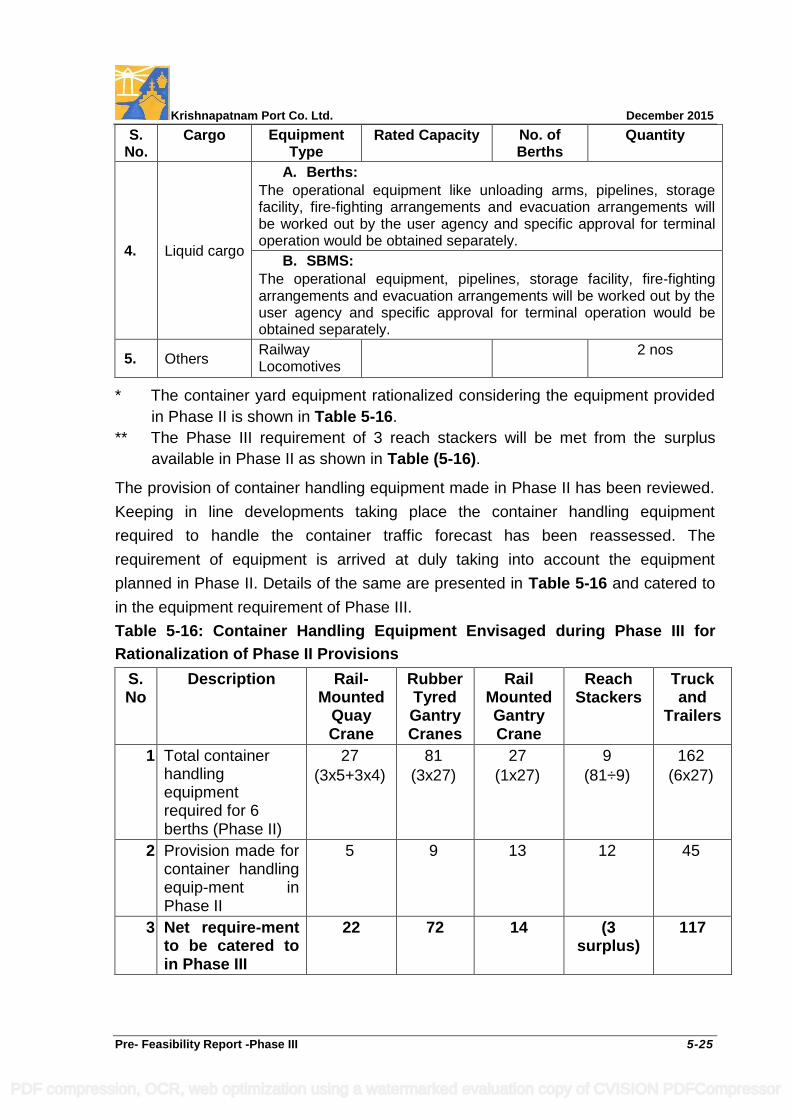
Krishnapatnam Port Co. Ltd. December 2015
Pre- Feasibility Report -Phase III 5-25
S. No.
Cargo Equipment Type
Rated Capacity No. of Berths
Quantity
4. Liquid cargo
A. Berths:
The operational equipment like unloading arms, pipelines, storage facility, fire-fighting arrangements and evacuation arrangements will be worked out by the user agency and specific approval for terminal operation would be obtained separately.
B. SBMS:
The operational equipment, pipelines, storage facility, fire-fighting arrangements and evacuation arrangements will be worked out by the user agency and specific approval for terminal operation would be obtained separately.
5. Others Railway Locomotives
2 nos
* The container yard equipment rationalized considering the equipment provided
in Phase II is shown in Table 5-16.
** The Phase III requirement of 3 reach stackers will be met from the surplus
available in Phase II as shown in Table (5-16).
The provision of container handling equipment made in Phase II has been reviewed.
Keeping in line developments taking place the container handling equipment
required to handle the container traffic forecast has been reassessed. The
requirement of equipment is arrived at duly taking into account the equipment
planned in Phase II. Details of the same are presented in Table 5-16 and catered to
in the equipment requirement of Phase III.
Table 5-16: Container Handling Equipment Envisaged during Phase III for
Rationalization of Phase II Provisions
S. No
Description Rail-Mounted
Quay Crane
Rubber Tyred Gantry Cranes
Rail Mounted Gantry Crane
Reach Stackers
Truck and
Trailers
1. Total container handling equipment required for 6 berths (Phase II)
27
(3x5+3x4)
81
(3x27)
27
(1x27)
9
(81÷9)
162
(6x27)
2. Provision made for container handling equip-ment in Phase II
5 9 13 12 45
3. Net require-ment to be catered to in Phase III
22 72 14 (3 surplus)
117
PDF compression, OCR, web optimization using a watermarked evaluation copy of CVISION PDFCompressor
Krishnapatnam Port Co. Ltd. December 2015
Pre- Feasibility Report -Phase III 5-26
5.1.8 Shore Protection near South & North Breakwaters
From the liquid cargo berths (LNG & POL), the pipelines are proposed to be laid on
trestles up to the breakwater and thereafter in a corridor of about 10 m wide each for
pipelines from each jetty, towards seaward side of existing south breakwater, as
laying of all the pipelines from the proposed three berths on the lee side of the
existing breakwater is not feasible due to likely multiple pipeline crossings.
As area towards the seaward side of the existing south breakwater where pipelines
are proposed to be located even though is getting accreted it would be subject to
wave attack during monsoons and cyclonic weather. To conserve the said land it is
proposed to undertake necessary protection works to withstand the incident waves
and reclaim the said area to uniform level by utilizing dredged sand. Further, control
houses and safety installations essential for handling liquid cargoes required are also
proposed to be accommodated in the same area. The extent of reclaimed area
between the proposed protection works from the kink of the south breakwater up to
the shore is Ha.16.50 (Ac.41). The length of the Shore protection from the kink to the
outfall point of the breakwater is about 1300 m. The reclaimed area lying beyond the
safety zone for the liquid berths would also be used for accommodating other
essential infrastructure control and safety installations & allied infrastructure
including breakwater maintenance yard. A layout showing the proposed shore
protection is enclosed as Drawing No.KP/PH-III/PFR/07.
Similarly it is proposed to conserve the accreting beach on the north of North
breakwater by means of a suitable designed shore protection work from shore upto
the kink of the North breakwater and reclaim the area of Ha.16 (Ac.40) between the
existing breakwater and Shore Protection would be reclaimed to uniform level by
utilizing dredged sand. The length of the Shore protection from the kink of North
Breakwater to the outfall point of the breakwater is about 1050m. The reclaimed area
lying beyond the safety zone for the POL berth would also be used for
accommodating other essential infrastructure control and safety installations & allied
infrastructure including breakwater maintenance yard. Layout of the proposed shore
protection on North of North Breakwater is also shown in the enclosed as
Drawing No.KP/PH-III/PFR/08.
PDF compression, OCR, web optimization using a watermarked evaluation copy of CVISION PDFCompressor
Krishnapatnam Port Co. Ltd. December 2015
Pre- Feasibility Report -Phase III 5-27
The design and cross-sections of the existing breakwaters which were arrived at by
undertaking 3D physical model studies during the Phase I & II developments of the
port are proposed to be adopted for the proposed shore protection work also, as may
be appropriate to the bed contours at the location. The proposed shore protection
works in shallow depths in the littoral zone is not going to influence the shore line
stability as the full length of breakwaters has been catered to in the numerical model
study carried out to ascertain the sediment transport during the earlier phases of the
port development. Further, the coastline on either side of the port is seen to
accreting except some minor seasonal changes. The coast on either side of the
harbor would continue to be an accreting as of now.
5.2 Population Projection
The population of Nellore District is 23.92 lakhs, 26.59 lakhs and 29.66 lakhs as per
1991, 2001, 2011 census respectively. The growth rates for decades 1991-2001 and
2001-2011 are 11.2% and 11.5%, respectively.
The urban population of Nellore district is 5.69 lakhs, 6.03 lakhs and 8.62 lakhs as
per 1991, 2001, 2011 census respectively. The annual growth rates during the
decades 1991-2001 and 2001-2011 are 0.5 % and 3.6%, respectively. The reason
for such a high annual urban population growth rate during the decade 2001-2011
may be attributed to Krishnapatnam Port development and other developments in
the region.
The proposed Phase III development of Krishnapatnam Port will encourage a
revolutionary development of the region including setting up of port based industries.
This would again result in a continued population influx to the urban areas and
transformation of some of the rural areas into urban areas. It is assumed that the
prevailing percentage growth rate of the decade 2001-2011 will continue in view of
the proposed development and the cumulative urban population of Nellore District in
2023 may reach 12.31 lakhs i.e. an increase of urban population by 3.69 lakhs.
PDF compression, OCR, web optimization using a watermarked evaluation copy of CVISION PDFCompressor
Krishnapatnam Port Co. Ltd. December 2015
Pre- Feasibility Report -Phase III 5-28
5.3 Development Strategy
The design vessel influencing the development of marine infrastructure in the
harbour area is the 380,000 DWT coal vessels. The coal vessel size being handled
alongside berths at most of the loading ports is from 170,000 DWT to 200,000 DWT.
Hence, it is proposed that the approach channel and manoeuvring areas will initially
cater to 180,000 DWT coal vessels and 18,400 TEU container vessels. However, the
design and construction of civil works of corresponding coal berths will cater to
300,000 DWT as well as the Valemax vessels (360,000-380,000 DWT) ship size to
enable deepening alongside such berths.
While feasibility for development of 2nd lane of the approach channel is included in
the Phase III to cater to 18,340 TEU design container vessel, deepening of the water
ways including the approach channel to cater to 300,000 DWT plus vessels will be
undertaken depending upon readiness of the loading ports and chartering of such
vessels to the port.
While only liquid handling berths are proposed under the present scope, leaving
corresponding handling equipment, operating facilities and storage requirements to
the actual user who is expected to obtain specific installation and operation
environmental clearance (EC) separately. Similarly EC is requested only for
construction the SBMs under the present scope while the EC for actual installations
and operations would be obtained separately by the actual operator.
5.4 Study of Alternative Layouts
In as much as the Phase III is a part of progressive development of the green field
port commissioned during 2009, within the Master Plan it is highly location specific
and therefore no alternative locations are relevant at this stage. Instead, two of the
feasible layout plans are examined. The first one is a modular extension without any
change in the existing plan of cargo handling locations whereas the second one
being a partially modified scheme of existing plan of cargo handling locations to
ensure an environmentally harmonious merging of the proposed extension for a
proper zoning of compatible cargoes.
The following aspects are common to these alternatives:
PDF compression, OCR, web optimization using a watermarked evaluation copy of CVISION PDFCompressor
Krishnapatnam Port Co. Ltd. December 2015
Pre- Feasibility Report -Phase III 5-29
The Phase II layout which was revised on account of non-availability of
designated lands (due to delay in handing over of land by GoAP) and submitted
for approval of MoEF, as shown in Drawing No. KP/PH-III/PFR/01, has been
adhered to.
In order to optimally utilize the land being leased by GoAP as per the Master
Plan, road and rail connectivity is to be formed to these areas from the port
entrance. Therefore, suitably designed road and rail bridges are considered
essential and have been proposed across the Khandaleru Creek without
impeding the creek hydraulics.
To improve creek hydraulics, it is proposed to straighten / divert the Khandaleru
Creek by forming a straight cut across the sand bar with cross section area not
less than that of the existing water course of the main arm of the Khandaleru
Creek. The existing meandering arms of the creek becoming redundant upon
forming the proposed straight cut are proposed to be reclaimed with dredged
material to utilize the same areas for the port use.
On both the banks of the proposed straight cut / diversion of the main arm of
Khandaleru Creek, it is intended to develop suitable berthing front for the port
use.
Out of the total 20 berths required in Phase III, it is proposed to accommodate 17
berths in the areas having immediate back up space, 2 nos liquid cargo berths for
LNG / POL / Chemicals on the lee of south breakwater with pipe line connections
to the respective storages areas away from berths and 1 no liquid cargo berth for
POL etc., on the lee of North breakwater with pipe line connections to the
respective end users away from berth.
The three SBMs are proposed within the port limits near the (-) 30 m CD contour.
As the three islands of the Ipuru RF area are being developed for port use as
contemplated in the Master Plan and the dormant creeks adjacent to these
islands are also proposed to be reclaimed for port use, mangrove development at
suitable areas in replacement of the existing sparse mangrove patches along
PDF compression, OCR, web optimization using a watermarked evaluation copy of CVISION PDFCompressor
Krishnapatnam Port Co. Ltd. December 2015
Pre- Feasibility Report -Phase III 5-30
periphery of the creeks adjacent to these islands would be undertaken duly
following the advice of experts in this field.
Four ephemeral drains exist in the development area; one of them serving as an
agricultural drain and the rest as drainage path for the defunct salt pans. The
agricultural drain would be diverted and maintained and a culvert is proposed for
one drain in the south which is crossing the port boundary and meeting the
Buckingham Canal. The other two local drains would be reclaimed along with salt
pans and the fish ponds except the part of one drain being maintained for tidal
exchange to the 9 acres of mangrove being protected.
5.4.1 Alternative Layout I
In this alternative, of the 17 berths requiring immediate backup area, it is proposed to
provide 10 berths by extending the northern dock in the north port and three berths
in the northwest dock. The western dock will be allocated for small craft and repair
facility. The allocation of berths required in Phase III is made keeping the re-
designation of berths mentioned above. The proposed layout of Alternative I is
shown in Drawing No. KP/PH-III/PFR/09.
5.4.2 Alternative Layout II
In this alternative, it is proposed to develop the berths required in Phase III by
creating docks in the north, west and northwest ports. In the west and northwest
ports, docks are proposed on both banks. In the north port on the north side it is
proposed to locate coal berths. The allocation of berths required in Phase III is made
keeping the re-designation of berths mentioned above. The proposed layout of
Alternative II is shown in Drawing No. KP/PH-III/PFR/10.
5.4.3 Evaluation of Alternative Layouts
Both alternatives are given appropriate weightages in Table 5-17 to evaluate and
arrive at the best option.
PDF compression, OCR, web optimization using a watermarked evaluation copy of CVISION PDFCompressor
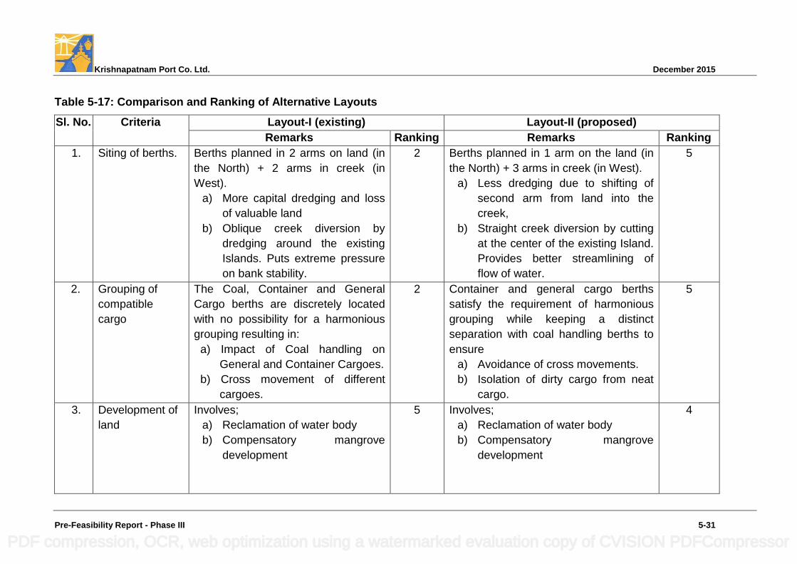
Krishnapatnam Port Co. Ltd. December 2015
Pre-Feasibility Report - Phase III 5-31
Table 5-17: Comparison and Ranking of Alternative Layouts
Sl. No. Criteria Layout-I (existing) Layout-II (proposed)
Remarks Ranking Remarks Ranking
1. Siting of berths. Berths planned in 2 arms on land (in
the North) + 2 arms in creek (in
West).
a) More capital dredging and loss
of valuable land
b) Oblique creek diversion by
dredging around the existing
Islands. Puts extreme pressure
on bank stability.
2 Berths planned in 1 arm on the land (in
the North) + 3 arms in creek (in West).
a) Less dredging due to shifting of
second arm from land into the
creek,
b) Straight creek diversion by cutting
at the center of the existing Island.
Provides better streamlining of
flow of water.
5
2. Grouping of
compatible
cargo
The Coal, Container and General
Cargo berths are discretely located
with no possibility for a harmonious
grouping resulting in:
a) Impact of Coal handling on
General and Container Cargoes.
b) Cross movement of different
cargoes.
2 Container and general cargo berths
satisfy the requirement of harmonious
grouping while keeping a distinct
separation with coal handling berths to
ensure
a) Avoidance of cross movements.
b) Isolation of dirty cargo from neat
cargo.
5
3. Development of
land
Involves;
a) Reclamation of water body
b) Compensatory mangrove
development
5 Involves;
a) Reclamation of water body
b) Compensatory mangrove
development
4
PDF compression, OCR, web optimization using a watermarked evaluation copy of CVISION PDFCompressor
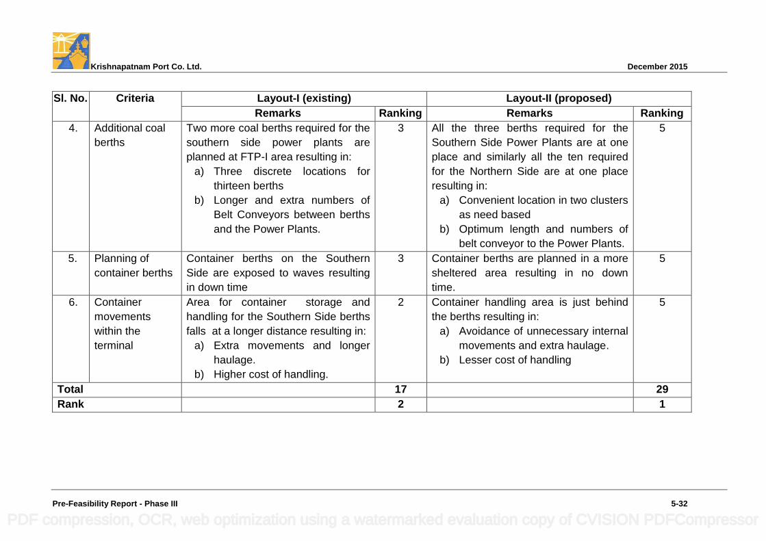
Krishnapatnam Port Co. Ltd. December 2015
Pre-Feasibility Report - Phase III 5-32
Sl. No. Criteria Layout-I (existing) Layout-II (proposed)
Remarks Ranking Remarks Ranking
4. Additional coal
berths
Two more coal berths required for the
southern side power plants are
planned at FTP-I area resulting in:
a) Three discrete locations for
thirteen berths
b) Longer and extra numbers of
Belt Conveyors between berths
and the Power Plants.
3 All the three berths required for the
Southern Side Power Plants are at one
place and similarly all the ten required
for the Northern Side are at one place
resulting in:
a) Convenient location in two clusters
as need based
b) Optimum length and numbers of
belt conveyor to the Power Plants.
5
5. Planning of
container berths
Container berths on the Southern
Side are exposed to waves resulting
in down time
3 Container berths are planned in a more
sheltered area resulting in no down
time.
5
6. Container
movements
within the
terminal
Area for container storage and
handling for the Southern Side berths
falls at a longer distance resulting in:
a) Extra movements and longer
haulage.
b) Higher cost of handling.
2 Container handling area is just behind
the berths resulting in:
a) Avoidance of unnecessary internal
movements and extra haulage.
b) Lesser cost of handling
5
Total 17 29
Rank 2 1
PDF compression, OCR, web optimization using a watermarked evaluation copy of CVISION PDFCompressor
Krishnapatnam Port Co. Ltd. December 2015
Pre-Feasibility Report - Phase III 5-33
From the above it may be seen that Alternative Layout II ranks 1st and permits
complete isolation of container handling terminals away from coal handling
terminals considering both up wind and downwind directions thereby is creating
a very congenial environment and compatibility of cargo handling which also
helps in attracting major international container terminal and shipping line
operators.
5.5 Recommended Port Layout
From Table 5-17 above, it is found that Alternative II satisfies the requirement
of compatibility of cargo handling, operational feasibility, environmental
compatibility and optimization of dredging quantity, and is also the most
suitable layout. The recommended port layout is shown in
Drawing No. KP/PH-III/PFR/03.
To render development of an integrated container handling terminal in the west
port area from considerations of road and rail connectivity and environmental
compatibility in cargo handling, it is proposed to re-designate the berths being
developed in Phase-I & II developments. The cargo handling contemplated at
the berths envisaged in Phase-I & II development as per EC accorded and the
proposed re-designation of these berths under the Phase-III development now
envisaged is presented in Table-18 hereunder:
PDF compression, OCR, web optimization using a watermarked evaluation copy of CVISION PDFCompressor
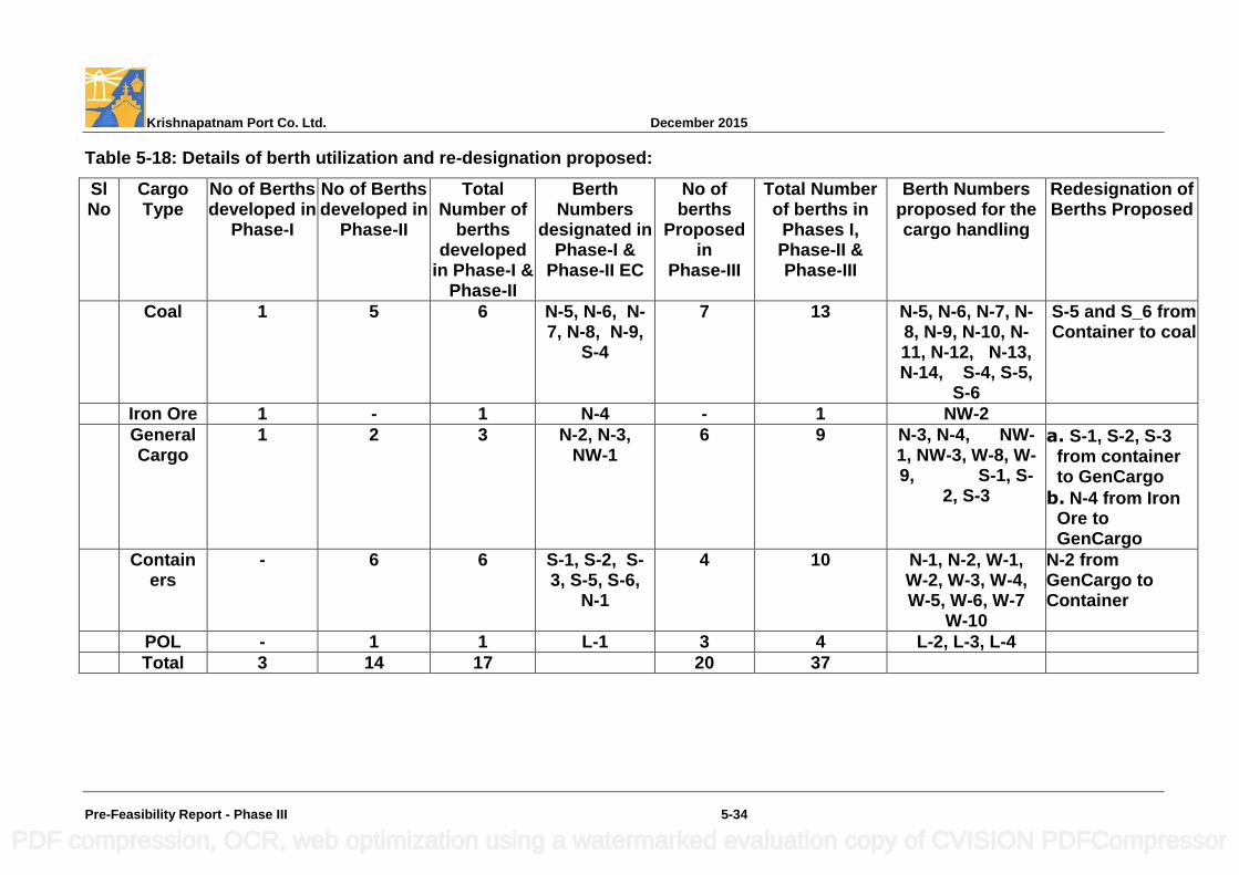
Krishnapatnam Port Co. Ltd. December 2015
Pre-Feasibility Report - Phase III 5-34
Table 5-18: Details of berth utilization and re-designation proposed:
Sl No
Cargo Type
No of Berths developed in
Phase-I
No of Berths developed in
Phase-II
Total Number of
berths developed
in Phase-I & Phase-II
Berth Numbers
designated in Phase-I &
Phase-II EC
No of berths
Proposed in
Phase-III
Total Number of berths in
Phases I, Phase-II & Phase-III
Berth Numbers proposed for the cargo handling
Redesignation of Berths Proposed
Coal 1 5 6 N-5, N-6, N-7, N-8, N-9,
S-4
7 13 N-5, N-6, N-7, N-8, N-9, N-10, N-11, N-12, N-13, N-14, S-4, S-5,
S-6
S-5 and S_6 from Container to coal
Iron Ore 1 - 1 N-4 - 1 NW-2
General Cargo
1 2 3 N-2, N-3, NW-1
6 9 N-3, N-4, NW-1, NW-3, W-8, W-9, S-1, S-
2, S-3
a. S-1, S-2, S-3 from container to GenCargo
b. N-4 from Iron Ore to GenCargo
Containers
- 6 6 S-1, S-2, S-3, S-5, S-6,
N-1
4 10 N-1, N-2, W-1, W-2, W-3, W-4, W-5, W-6, W-7
W-10
N-2 from GenCargo to Container
POL - 1 1 L-1 3 4 L-2, L-3, L-4
Total 3 14 17 20 37
PDF compression, OCR, web optimization using a watermarked evaluation copy of CVISION PDFCompressor
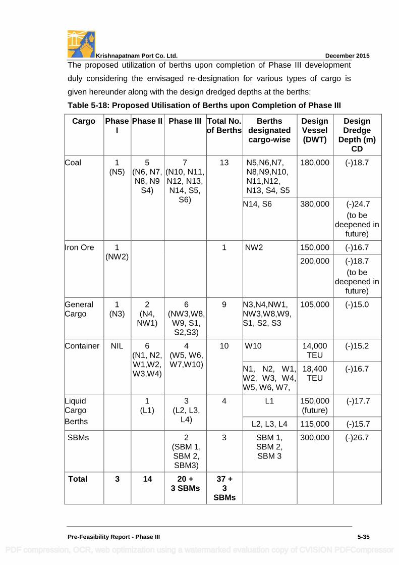
Krishnapatnam Port Co. Ltd. December 2015
Pre-Feasibility Report - Phase III 5-35
The proposed utilization of berths upon completion of Phase III development
duly considering the envisaged re-designation for various types of cargo is
given hereunder along with the design dredged depths at the berths:
Table 5-18: Proposed Utilisation of Berths upon Completion of Phase III
Cargo Phase I
Phase II Phase III Total No. of Berths
Berths designated cargo-wise
Design Vessel (DWT)
Design Dredge
Depth (m) CD
Coal 1 (N5)
5 (N6, N7, N8, N9
S4)
7 (N10, N11, N12, N13, N14, S5,
S6)
13 N5,N6,N7, N8,N9,N10, N11,N12, N13, S4, S5
180,000 (-)18.7
N14, S6 380,000 (-)24.7
(to be deepened in
future)
Iron Ore 1 (NW2)
1 NW2 150,000 (-)16.7
200,000 (-)18.7
(to be deepened in
future)
General Cargo
1 (N3)
2 (N4,
NW1)
6 (NW3,W8,W9, S1, S2,S3)
9 N3,N4,NW1, NW3,W8,W9, S1, S2, S3
105,000 (-)15.0
Container NIL 6 (N1, N2, W1,W2, W3,W4)
4 (W5, W6, W7,W10)
10 W10 14,000 TEU
(-)15.2
N1, N2, W1, W2, W3, W4, W5, W6, W7,
18,400 TEU
(-)16.7
Liquid Cargo
Berths
1 (L1)
3 (L2, L3,
L4)
4 L1 150,000 (future)
(-)17.7
L2, L3, L4 115,000 (-)15.7
SBMs 2 (SBM 1, SBM 2, SBM3)
3 SBM 1, SBM 2, SBM 3
300,000 (-)26.7
Total 3 14 20 + 3 SBMs
37 + 3
SBMs
PDF compression, OCR, web optimization using a watermarked evaluation copy of CVISION PDFCompressor
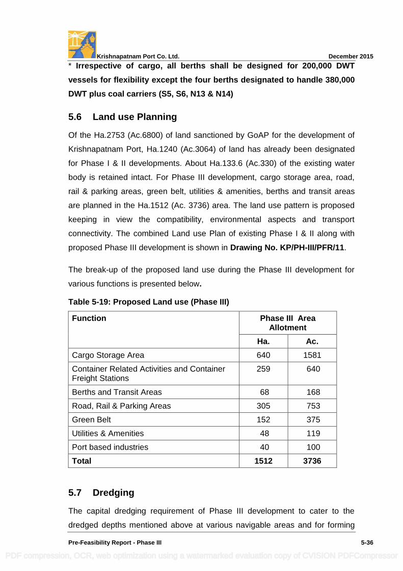
Krishnapatnam Port Co. Ltd. December 2015
Pre-Feasibility Report - Phase III 5-36
* Irrespective of cargo, all berths shall be designed for 200,000 DWT
vessels for flexibility except the four berths designated to handle 380,000
DWT plus coal carriers (S5, S6, N13 & N14)
5.6 Land use Planning
Of the Ha.2753 (Ac.6800) of land sanctioned by GoAP for the development of
Krishnapatnam Port, Ha.1240 (Ac.3064) of land has already been designated
for Phase I & II developments. About Ha.133.6 (Ac.330) of the existing water
body is retained intact. For Phase III development, cargo storage area, road,
rail & parking areas, green belt, utilities & amenities, berths and transit areas
are planned in the Ha.1512 (Ac. 3736) area. The land use pattern is proposed
keeping in view the compatibility, environmental aspects and transport
connectivity. The combined Land use Plan of existing Phase I & II along with
proposed Phase III development is shown in Drawing No. KP/PH-III/PFR/11.
The break-up of the proposed land use during the Phase III development for
various functions is presented below.
Table 5-19: Proposed Land use (Phase III)
Function Phase III Area Allotment
Ha. Ac.
Cargo Storage Area 640 1581
Container Related Activities and Container Freight Stations
259 640
Berths and Transit Areas 68 168
Road, Rail & Parking Areas 305 753
Green Belt 152 375
Utilities & Amenities 48 119
Port based industries 40 100
Total 1512 3736
5.7 Dredging
The capital dredging requirement of Phase III development to cater to the
dredged depths mentioned above at various navigable areas and for forming
PDF compression, OCR, web optimization using a watermarked evaluation copy of CVISION PDFCompressor
Krishnapatnam Port Co. Ltd. December 2015
Pre-Feasibility Report - Phase III 5-37
the second lane of the approach channel to cater to 18,400 TEU / 14,000 TEU
container vessels, a total quantity of about 63 million cum of soft soil dredging
is assessed.
The material to be dredged mainly comprises of sand and silty soil which can
be used for reclamation of the low lying areas to be used for development of
port infrastructure including back up areas for berths to the extent needed.
Out of the 63 million cum to be dredged, a quantity of about 28 million cum
would be utilized for reclamation of low lying areas to be utilized as back up
areas and the balance i.e., about 35 million cum would be disposed-off in the
sea at the disposal areas already identified during Phase II in deeper areas i.e.,
beyond (-) 20 m contour. A total of 25 million cum of dredged material was
disposed-off during Phase II at the disposal area as against 43 (52-9) million
cum planned and no significant build up in the bed contours is noticed due to
uniform spreading in a large area and effective dispersion.
As the quantity of dredged material proposed to be disposed-off at the
identified disposal area of (35 sq. km) 7 km x 5 km in the sea is 35 million cum
spread in about 4 years (time frame assessed for implementation of Phase III
development), with an average of about 8.75 million cum per year, the
bathymetry of the dredge dumping ground is not likely to cause any concern.
All precautions now being followed for disposal of dredged material will be
continued to be followed during the implementation of Phase III also and the
dredge disposal area will be continued to be monitored as of now.
Further capital dredging for deepening of the navigable water ways to cater to
380,000 DWT coal vessels / 200,000 DWT iron ore vessels and dredging
associated with SBMs will be undertaken depending upon the readiness of the
loading / unloading ports and chartering of such vessels to the port.
The proposed dredging layout is shown in Drawing No. KP/PH-III/PFR/12. The
location plan of the dredged material disposal areas is shown in
Drawing No. KP/PH-III/PFR/13.
PDF compression, OCR, web optimization using a watermarked evaluation copy of CVISION PDFCompressor
Krishnapatnam Port Co. Ltd. December 2015
Pre-Feasibility Report - Phase III 5-38
5.8 Maintenance Dredging
M/s HR Wallingford have carried out simulation of the spring and neap tidal
conditions at Krishnapatnam Port using SANDFLOW 2D and TELEMAC 2D
models and have calculated the tidally induced sedimentation, both sand and
mud, in the approach channel and harbor areas. The annual maintenance
dredging anticipated upon completion of envisaged Phase III development is
about 1.02 million cum. The same is proposed to be disposed off at the
identified disposal areas beyond (-) 20 m CD Contour.
5.9 Reclamation
The proposed finished ground level of the land developed in Phases I & II is (+)
3.9 m CD. An area of about Ha.1512 (Ac.3736) is proposed to be developed in
Phase III also to the same level. This also include reclamation of areas in the
water bodies lying in the west port area measuring about Ha.133.80 (Ac.330)
adjacent to the Ipuru Forest area and Ha.32 (Ac. 80) in between the existing
breakwaters and the proposed Shore protection at North & South sides. The
areas proposed to be reclaimed are shown in Drawing No. KP/PH-III/PFR/14.
The quantity of material required for reclamation of Phase III land is about 39
million cum. While considering that the top 0.50 m of the fill is gravel or hard-
standing / pavement, about 29 million cum of the dredged material will be used
for reclamation of the low lying areas. The existing ephemeral drains proposed
to be integrated with the project area are also shown in this drawing.
5.10 Assessment of Infrastructure Demand
5.10.1 Road Connectivity
A 23 km long 4 lane wide dedicated port road connectivity has been formed
connecting the National Highway (NH 16) by GoAP as an external
infrastructure. It is feasible to widen the same to 6 lanes as and when needed
to meet increasing traffic. Thus, the local roads will not experience any impact
on account of the proposed Phase II development of Krishnapatnam Port.
To optimally utilize the land in the north, south and west ports connectivity to
external road network is required. Accordingly, in continuation to the roads
PDF compression, OCR, web optimization using a watermarked evaluation copy of CVISION PDFCompressor
Krishnapatnam Port Co. Ltd. December 2015
Pre-Feasibility Report - Phase III 5-39
planned in the south and west port required bridges are planned across the
Khandaleru Creek, Buckingham Canal and the existing creek in the north port
to facilitate continuity of road access.
The main internal roads catering to the container yard, bulk cargo yards,
general cargo are planned for 4 lane development. The other internal roads
shall be of 2 lane width, roads with nominal traffic and the peripheral road along
the boundary shall be of single lane width. A total length of 97 km of 4 lane
roads, 69 km of 2 lane roads, 7 Km of Single lane road and 5 nos of Road
Flyovers on Railway lines would be formed in Phase III. Suitably designed
storm water drains are also planned adjacent to the roads.
5.10.2 Railway Connectivity
A 19.4 km long dedicated double line electrified port rail connectivity has been
formed by RVNL in JV with KPCL, GoAP and NMDC. Internal railway lines
shall cater to all the cargo yards namely containers, bulk cargo, fertiliser, liquid
cargoes and general cargoes.
To optimally utilize the land in the north, south and west ports connectivity to
the external rail network is required. Accordingly, in continuation to the rail
sidings and lines planned in the north, south and west ports, required number
of rail bridges are planned across the Khandaleru Creek, Upputeru Creek and
Buckingham Canal.
To improve the overall efficiency of the operations, a merry go round system is
planned as being insisted by the trunk railways. Adequate loop lines, lines for
engine escape, break vans; sick wagons and repair facilities are also catered to
in the planning. In the Phase III, 168.0 TKM of broad gauge railway line with
provision for electrification is provided. Krishnapatnam Port owns 4 (four)
locomotives, it is proposed to increase the same to 6 nos to cater to the
increasing demand of the Phase III development. Three yard master buildings,
one each in the north, south and west ports are proposed to ensure proper
signaling and railway operations. Three loco parking bays, one each in the
north, west and south ports are proposed to for repair and maintenance of the
PDF compression, OCR, web optimization using a watermarked evaluation copy of CVISION PDFCompressor
Krishnapatnam Port Co. Ltd. December 2015
Pre-Feasibility Report - Phase III 5-40
locomotives. The layout of railway yards including take off points for various
yard etc., would be firmed up during further detailing
The internal road and rail network of Krishnapatnam Port is as shown in
Drawing No. KP/PH-III/PFR/15.
5.10.3 Bridges
To connect the port‟s operational area lying towards south of Khandaleru Creek
and east of the Buckingham Canal with road and railway network on the west
(exit corridor) in the north and to facilitate faster deployment of heavy duty
trucks and railways for transport of cargo to / from port and hinterland as well
as reduce smoke emissions from cargo trucks, following bridges / culverts are
required to be taken up during the proposed Phase III development in addition
to those formed during the Phase I & II developments of the port:
Development of Road Bridge RB22 & Rail Bridge RB-11
Relocation of Road Bridge RB-7 & Railway Bridge RB10 is proposed on
the Khandaleru Creek.
Two road bridges (RB21 & RB 23) & one Road Bridge – cum - Flyover
(RB12) are proposed on Buckingham Canal.
Two Road Bridges (RB19 & RB20) on the diverted drain / creek.
To provide railway and road connectivity between iron ore yard in the
west port area and coal yards in the north port area for movement of
empty iron ore rakes for effective utilization for coal loading etc., the
existing road bridge “EX1” across Upputeru Creek is proposed to be
modified as road-cum-rail Bridge.
Strengthening of 3 existing bridges / culverts on Buckingham Canal
(RB16, RB17, RB18) to integrate the Port‟s operational area separated
by creek system and to facilitate faster deployment of heavy duty trucks
and railways for transport of cargo to / from port and hinterland as well
as reduce smoke emissions from cargo trucks are also proposed.
PDF compression, OCR, web optimization using a watermarked evaluation copy of CVISION PDFCompressor
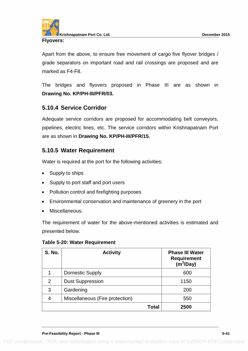
Krishnapatnam Port Co. Ltd. December 2015
Pre-Feasibility Report - Phase III 5-41
Flyovers:
Apart from the above, to ensure free movement of cargo five flyover bridges /
grade separators on important road and rail crossings are proposed and are
marked as F4-F8.
The bridges and flyovers proposed in Phase III are as shown in
Drawing No. KP/PH-III/PFR/03.
5.10.4 Service Corridor
Adequate service corridors are proposed for accommodating belt conveyors,
pipelines, electric lines, etc. The service corridors within Krishnapatnam Port
are as shown in Drawing No. KP/PH-III/PFR/15.
5.10.5 Water Requirement
Water is required at the port for the following activities:
Supply to ships
Supply to port staff and port users
Pollution control and firefighting purposes
Environmental conservation and maintenance of greenery in the port
Miscellaneous.
The requirement of water for the above-mentioned activities is estimated and
presented below.
Table 5-20: Water Requirement
S. No. Activity Phase III Water Requirement
(m3/Day)
1 Domestic Supply 600
2 Dust Suppression 1150
3 Gardening 200
4 Miscellaneous (Fire protection) 550
Total 2500
PDF compression, OCR, web optimization using a watermarked evaluation copy of CVISION PDFCompressor
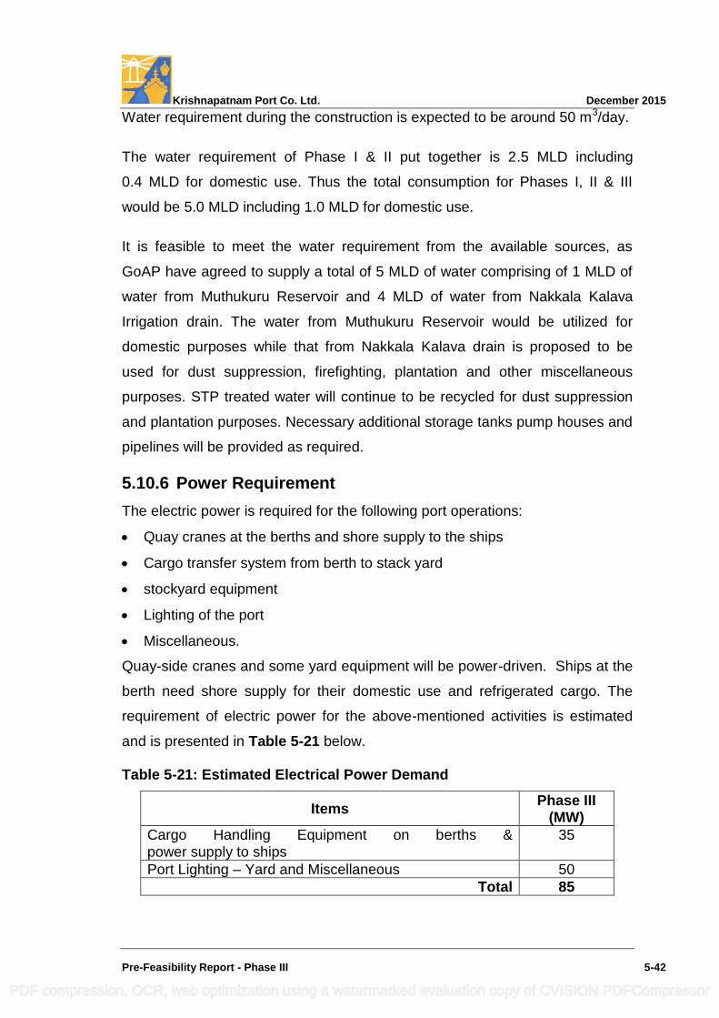
Krishnapatnam Port Co. Ltd. December 2015
Pre-Feasibility Report - Phase III 5-42
Water requirement during the construction is expected to be around 50 m3/day.
The water requirement of Phase I & II put together is 2.5 MLD including
0.4 MLD for domestic use. Thus the total consumption for Phases I, II & III
would be 5.0 MLD including 1.0 MLD for domestic use.
It is feasible to meet the water requirement from the available sources, as
GoAP have agreed to supply a total of 5 MLD of water comprising of 1 MLD of
water from Muthukuru Reservoir and 4 MLD of water from Nakkala Kalava
Irrigation drain. The water from Muthukuru Reservoir would be utilized for
domestic purposes while that from Nakkala Kalava drain is proposed to be
used for dust suppression, firefighting, plantation and other miscellaneous
purposes. STP treated water will continue to be recycled for dust suppression
and plantation purposes. Necessary additional storage tanks pump houses and
pipelines will be provided as required.
5.10.6 Power Requirement
The electric power is required for the following port operations:
Quay cranes at the berths and shore supply to the ships
Cargo transfer system from berth to stack yard
stockyard equipment
Lighting of the port
Miscellaneous.
Quay-side cranes and some yard equipment will be power-driven. Ships at the
berth need shore supply for their domestic use and refrigerated cargo. The
requirement of electric power for the above-mentioned activities is estimated
and is presented in Table 5-21 below.
Table 5-21: Estimated Electrical Power Demand
Items Phase III
(MW)
Cargo Handling Equipment on berths & power supply to ships
35
Port Lighting – Yard and Miscellaneous 50
Total 85
PDF compression, OCR, web optimization using a watermarked evaluation copy of CVISION PDFCompressor
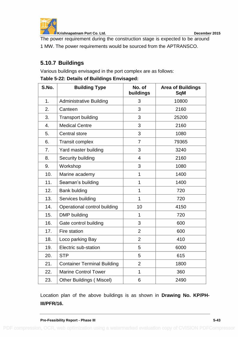
Krishnapatnam Port Co. Ltd. December 2015
Pre-Feasibility Report - Phase III 5-43
The power requirement during the construction stage is expected to be around
1 MW. The power requirements would be sourced from the APTRANSCO.
5.10.7 Buildings
Various buildings envisaged in the port complex are as follows:
Table 5-22: Details of Buildings Envisaged:
S.No. Building Type No. of buildings
Area of Buildings SqM
1. Administrative Building 3 10800
2. Canteen 3 2160
3. Transport building 3 25200
4. Medical Centre 3 2160
5. Central store 3 1080
6. Transit complex 7 79365
7. Yard master building 3 3240
8. Security building 4 2160
9. Workshop 3 1080
10. Marine academy 1 1400
11. Seaman‟s building 1 1400
12. Bank bulding 1 720
13. Services building 1 720
14. Operational control building 10 4150
15. DMP building 1 720
16. Gate control building 3 600
17. Fire station 2 600
18. Loco parking Bay 2 410
19. Electric sub-station 5 6000
20. STP 5 615
21. Container Terminal Building 2 1800
22. Marine Control Tower 1 360
23. Other Buildings ( Miscel) 6 2490
Location plan of the above buildings is as shown in Drawing No. KP/PH-
III/PFR/16.
PDF compression, OCR, web optimization using a watermarked evaluation copy of CVISION PDFCompressor
Krishnapatnam Port Co. Ltd. December 2015
Pre-Feasibility Report - Phase III 5-44
5.11 Amenities / Facilities
5.11.1 Navigational Aids
The following navigational aids are proposed for Phase III of Krishnapatnam
Port:
Fairway buoys
Channel marker buoys
Front and rear leading light towers
5.11.2 Port Craft
The port should provide pilot assistance for safe maneuvering of ships and
suitable capacity tugs to bring vessels safely along the berths. Two tugs of
capacity 70 T bollard pull, two tugs of 50T bollard pull and a 25 knots speed
pilot launch are required in addition to mooring launches. As in Phase II, the
port crafts required in Phase III are proposed to be procured by outsourcing
from suitable agencies.
5.11.3 General Lighting
General lighting of the port will be provided using light towers of suitable height
and at appropriate spacing. The average lighting level will be 50 Lux. Additional
lighting will be provided where required for special purposes.
5.11.4 Storm Water Drainage
A network of storm water drains will be provided. The entire storage area, quay
aprons and traffic lanes will be provided with sloping surfaces towards drainage
canals. Run off from the coal storage areas will be routed through collection
pits and guard ponds with re-circulation facility.
In order to avoid contamination of the harbour basin, the following design
features will be applied:
Truck wash areas will be provided with suitable oil and grease separation
facilities for recirculation and re-cycling of water.
Dust suppression systems are proposed in the stockyard to reduce air
pollution caused by handling coal. A network of surface drains is proposed
to collect water flowing from the stockyards and lead into the guard ponds.
PDF compression, OCR, web optimization using a watermarked evaluation copy of CVISION PDFCompressor
Krishnapatnam Port Co. Ltd. December 2015
Pre-Feasibility Report - Phase III 5-45
5.11.5 Bunkering
Provision for supply of fuel oil and fresh water bunkering will be made.
5.11.6 Environmental Aspects
At the bulk cargo storage and vehicular movement areas, dust suppression
measures by mechanized spraying of water shall be resorted to. Further details
as required would be incorporated during implementation stage to confirm to
the EMP proposed in the EIA report.
In Phase III, green belt development is planned along the boundary (50 m
wide) and along periphery of dust generating cargoes (20 m wide) to contain
the dust / pollution. It is also proposed to develop 13 ha of green pastures on
the southern beach. In addition, avenue plantation is proposed along the
median and alongside the road. About 152 ha of greenbelt development is
proposed during the Phase-III development of the port.
The berths and aprons will be provided with a slope towards drains and the
wash / runoff waters from these areas will be routed to suitable solids collection
pits.
Monitoring of the environmental parameters of ambient air quality, noise,
marine and ground water quality will be carried out confirming to statutory
standards. General environmental protection works also include:
a. Environmental studies during Phase III development
b. STPs for treatment of waste water
c. Alteration of drainage features within the port boundary
d. Dust suppression
e. Replacement of mangroves
f. Oil spill contingency measures
g. Road sweeping equipment
h. Augmentation of continuous AAQ monitoring equipment
The mechanical cargo handling system cost estimates provide for necessary
dust suppression measures. For all other works mentioned above, provision is
made in the cost estimate under the head „environmental protection works.
PDF compression, OCR, web optimization using a watermarked evaluation copy of CVISION PDFCompressor
Krishnapatnam Port Co. Ltd. December 2015
Pre- Feasibility Report - Phase III 6-1
6 PROPOSED INFRASTRUCTURE
This chapter describes details of infrastructure proposed for Phase III development
in the processing and non-processing areas with due attention to environmental
aspects.
6.1 Port Area (Processing Area)
6.1.1 Infrastructure Proposed in Phase III
The infrastructures proposed in Phase III are as follows:
o 20 berths and 3 SBMs to handle the following cargo:
o 7 berths to handle 88 MTPA of coal
o 6 berths to handle 14 MTPA of general cargo like (Fertilizer, agri-products,
granite, edible oil, lube oil, barytes and others)
o 4 berths to handle 2.2 MTEUs of container cargo and commensurate
equipment to rationalize the requirement planned in Phase II
o 3 berths to handle 25 MTPA of liquid cargo (Crude oil, POL, LNG, LPG) and
o 3 SBMs to handle 18 MTPA of crude oil and 9 MTPA of Products
o Cargo Storage area for the envisaged Phase-III Traffic demand is Ha. 973
(Ac.2402).
o Storage area for cargoes other than containers is Ha.900 (Ac.2220)
o Coal - Ha.204 (Ac.504)
o Fertiliser & Agri Products - Ha. 57 (Ac.140)
o Other general cargo - Ha.193 (Ac.477)
o Liquid cargo - Ha.186 (Ac.460)
o Area for Container storage and related activities is Ha.259 (Ac.640)
o Container storage - Ha.239 (Ac.590)
o Container related activities like refers etc,. - Ha. 9 (Ac. 23)
o Container freight station - Ha. 20 (Ac. 50)
o Berths and transit areas - Ha. 40 (Ac.100)
o Road, rail & parking areas - Ha. 72 (Ac.178)
o Green belt - Ha.152 (Ac.375)
o Utilities & amenities - Ha. 49 (Ac.120)
o Port based industries - Ha. 40 (Ac.100)
Total area required for Phase III development - Ha.1512 (Ac.3736)
PDF compression, OCR, web optimization using a watermarked evaluation copy of CVISION PDFCompressor
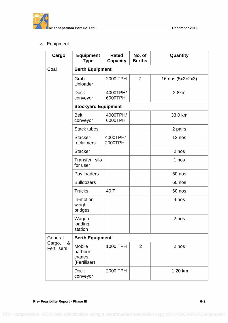
Krishnapatnam Port Co. Ltd. December 2015
Pre- Feasibility Report - Phase III 6-2
o Equipment
Cargo Equipment Type
Rated Capacity
No. of Berths
Quantity
Coal Berth Equipment
Grab Unloader
2000 TPH 7 16 nos (5x2+2x3)
Dock conveyor
4000TPH/ 6000TPH
2.8km
Stockyard Equipment
Belt conveyor
4000TPH/ 6000TPH
33.0 km
Stack tubes 2 pairs
Stacker-reclaimers
4000TPH/ 2000TPH
12 nos
Stacker 2 nos
Transfer silo for user
1 nos
Pay loaders 60 nos
Bulldozers 60 nos
Trucks 40 T 60 nos
In-motion weigh bridges
4 nos
Wagon loading station
2 nos
General Cargo, & Fertilisers
Berth Equipment
Mobile harbour cranes (Fertiliser)
1000 TPH 2 2 nos
Dock conveyor
2000 TPH 1.20 km
PDF compression, OCR, web optimization using a watermarked evaluation copy of CVISION PDFCompressor
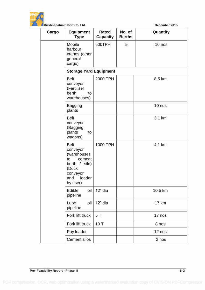
Krishnapatnam Port Co. Ltd. December 2015
Pre- Feasibility Report - Phase III 6-3
Cargo Equipment Type
Rated Capacity
No. of Berths
Quantity
Mobile harbour cranes (other general cargo)
500TPH 5 10 nos
Storage Yard Equipment
Belt conveyor (Fertiliser berth to warehouses)
2000 TPH 8.5 km
Bagging plants
10 nos
Belt conveyor (Bagging plants to wagons)
3.1 km
Belt conveyor (warehouses to cement berth / silo) (Dock conveyor and loader by user)
1000 TPH 4.1 km
Edible oil pipeline
12” dia 10.5 km
Lube oil pipeline
12” dia 17 km
Fork lift truck 5 T 17 nos
Fork lift truck 10 T 8 nos
Pay loader 12 nos
Cement silos 2 nos
PDF compression, OCR, web optimization using a watermarked evaluation copy of CVISION PDFCompressor
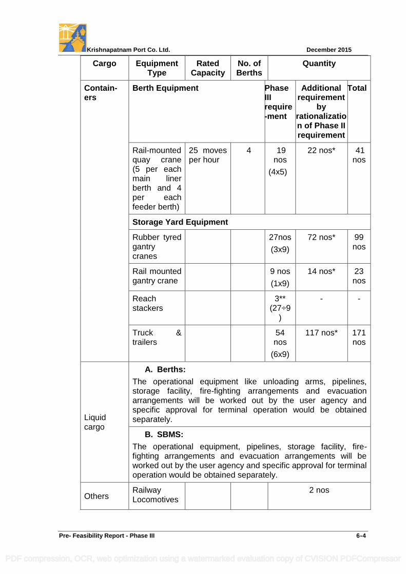
Krishnapatnam Port Co. Ltd. December 2015
Pre- Feasibility Report - Phase III 6-4
Cargo Equipment Type
Rated Capacity
No. of Berths
Quantity
Contain-ers
Berth Equipment Phase III require -ment
Additional requirement
by rationalization of Phase II requirement
Total
Rail-mounted quay crane (5 per each main liner berth and 4 per each feeder berth)
25 moves per hour
4 19 nos
(4x5)
22 nos* 41 nos
Storage Yard Equipment
Rubber tyred gantry cranes
27nos
(3x9)
72 nos* 99 nos
Rail mounted gantry crane
9 nos
(1x9)
14 nos* 23 nos
Reach stackers
3** (27÷9
)
- -
Truck & trailers
54 nos
(6x9)
117 nos* 171nos
Liquid cargo
A. Berths:
The operational equipment like unloading arms, pipelines, storage facility, fire-fighting arrangements and evacuation arrangements will be worked out by the user agency and specific approval for terminal operation would be obtained separately.
B. SBMS:
The operational equipment, pipelines, storage facility, fire-fighting arrangements and evacuation arrangements will be worked out by the user agency and specific approval for terminal operation would be obtained separately.
Others Railway Locomotives
2 nos
PDF compression, OCR, web optimization using a watermarked evaluation copy of CVISION PDFCompressor
Krishnapatnam Port Co. Ltd. December 2015
Pre- Feasibility Report - Phase III 6-5
* Container Handling Equipment Envisaged during Phase III for Rationalization
of Phase II Provisions is shown in Table 5-16.
** The Phase III requirement of 3 reach stackers will be met from the surplus
provision available in Phase II as shown in Table (5-16).
o Dredging and disposal of dredged spoil
(including the 2nd lane of the approach channel)
o Capital dredging - 63 million cum
o Dredge material to be used for reclamation - 29 million cum
o Disposal of dredged spoil at identified disposal areas beyond (-) 20 mCD - 34 million cum
o Annual maintenance dredging and disposal of dredged spoil at identified disposal areas beyond (-) 20 mCD Contour - 1.02 million cum
o Rubble mound Shore Protection along the shoreward reclamation of the
South & North breakwater about 1300 m and 1050m long respectively
o Reclamation of the enclosed area between the breakwaters and the rubble
mound shore protection ( about Ac. 41 on the southern side and Ac. 40 on the
northern side) and to utilize the same for pipeline corridors for the LNG, LPG,
POL & crude oil and to accommodate related essential control / safety
installations and allied infrastructure including breakwater maintenance
facility.
o Reclamation of 39 million cum comprising of 29 million cum of dredged
material. The remaining 10 million cum would comprise of gravel / hard-
standing / pavement.
o Straightening of Khandaleru Creek by forming straight cut across the existing
sand bar and thereafter reclamation of meandering north and south arms (Ha.
133.80) to develop back space required for the berths
o Development of mangroves in replacement of those existing in the project
area to suitable area in the proximity of the port
o Internal roads
o 4 lane roads - 97 km
o 2 lane roads - 69 km;
o Single Lane - 7 km
o Adequate truck parking – Ha.60 (Ac.100)
PDF compression, OCR, web optimization using a watermarked evaluation copy of CVISION PDFCompressor
Krishnapatnam Port Co. Ltd. December 2015
Pre- Feasibility Report - Phase III 6-6
o Internal railway lines and sidings 168 TKM with 3 numbers of loco Parking Bay
for day to day repairs & maintenance of the locomotives
o Bridges
o Bridges on Khandaleru Creek
Two road bridges (RB7 & RB22)
Two railway bridge (RB10, RB11)
o Bridges on Buckingham Canal
Two road bridges (RB21 & RB 23)
One Road bridge-cum-flyover (RB12)
o Bridges on drain / creek
Two road bridges (RB19 & RB20)
o Modification / Relocation of existing road bridge (EX1) as road-cum-rail bridge on
Upputeru Creek
o Strengthening of existing bridges / Culverts on Buckingham Canal
Three Road Bridges (RB16, RB17, RB18)
o Five flyovers (F4,F5,F6,F7 & F8)
o Gate complexes, weigh bridges, administrative, operational and functional,
welfare and amenities buildings.
o 10 control buildings - Two near corners of North dock (CB-1 & CB-2), One along
western end of the Northern Arm (CB-3), Two near corners of the North-West
dock (CB-4 & CB-5), four on the corners of the Western Dock (CB-6,CB-7,CB-8 &
CB-9) and one near western end of the Southern berthing front (CB-10).
o Port craft jetty - 800m long
o Coast Guard Jetty - 200m long
o Dry Dock & Repair facility
Repair dry dock No 1- 150 m length, 40 m width and 12.0 m depth
(with -9.5 m sill level at entrance) with repair quay - 200 m long
Repair dry dock No 2- 335 m length, 65 m width and 15.0 m depth (with
-12.5 m sill level at entrance) with a leading in jetty of 100 m long and repair
quay/ Fit out wharf - 250 m long
o Utilities like Power, Water supply. Sewage treatment plant etc.
o Environmental works like STP, dust suppression measures, mangrove development and greenbelt development.
o Development of green pastures on southern beach for aesthetic upgradation.
PDF compression, OCR, web optimization using a watermarked evaluation copy of CVISION PDFCompressor
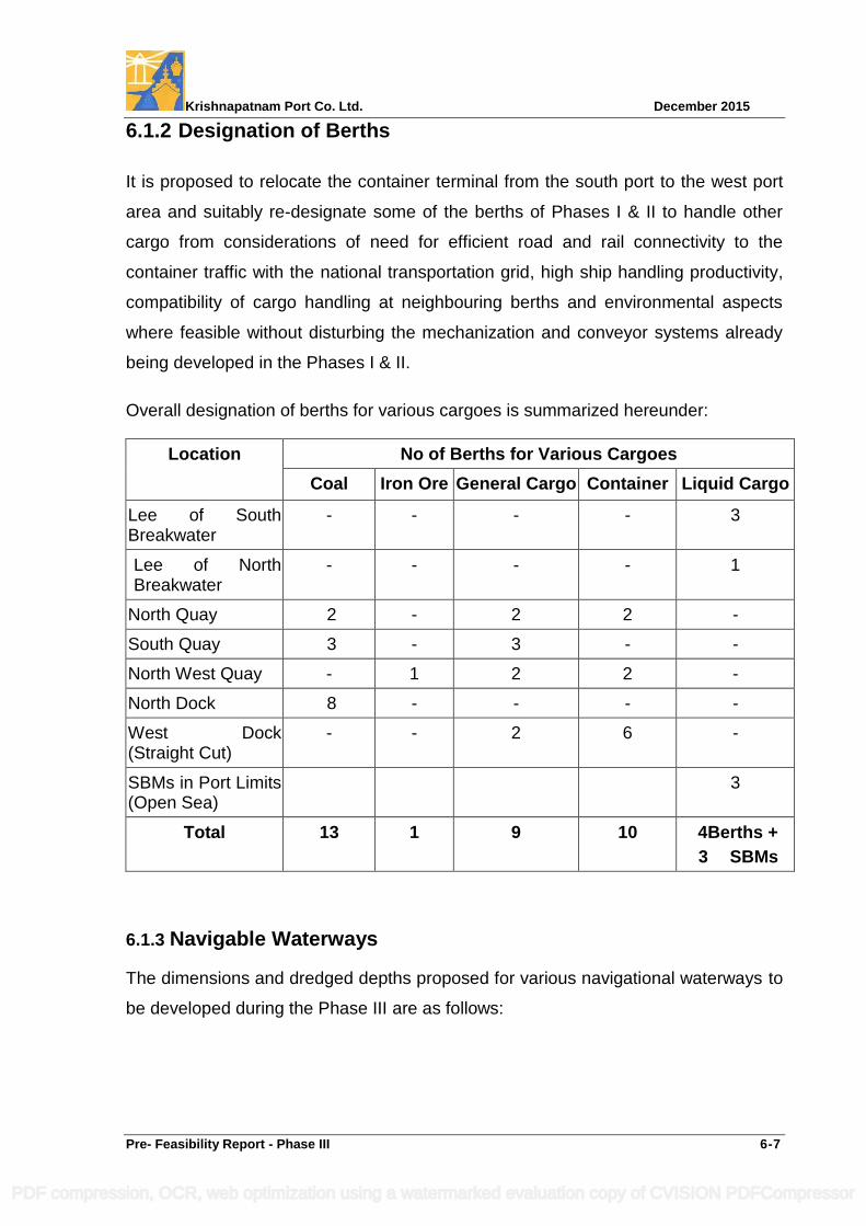
Krishnapatnam Port Co. Ltd. December 2015
Pre- Feasibility Report - Phase III 6-7
6.1.2 Designation of Berths
It is proposed to relocate the container terminal from the south port to the west port
area and suitably re-designate some of the berths of Phases I & II to handle other
cargo from considerations of need for efficient road and rail connectivity to the
container traffic with the national transportation grid, high ship handling productivity,
compatibility of cargo handling at neighbouring berths and environmental aspects
where feasible without disturbing the mechanization and conveyor systems already
being developed in the Phases I & II.
Overall designation of berths for various cargoes is summarized hereunder:
Location No of Berths for Various Cargoes
Coal Iron Ore General Cargo Container Liquid Cargo
Lee of South Breakwater
- - - - 3
Lee of North Breakwater
- - - - 1
North Quay 2 - 2 2 -
South Quay 3 - 3 - -
North West Quay - 1 2 2 -
North Dock 8 - - - -
West Dock (Straight Cut)
- - 2 6 -
SBMs in Port Limits (Open Sea)
3
Total 13 1 9 10 4Berths +
3 SBMs
6.1.3 Navigable Waterways
The dimensions and dredged depths proposed for various navigational waterways to
be developed during the Phase III are as follows:
PDF compression, OCR, web optimization using a watermarked evaluation copy of CVISION PDFCompressor
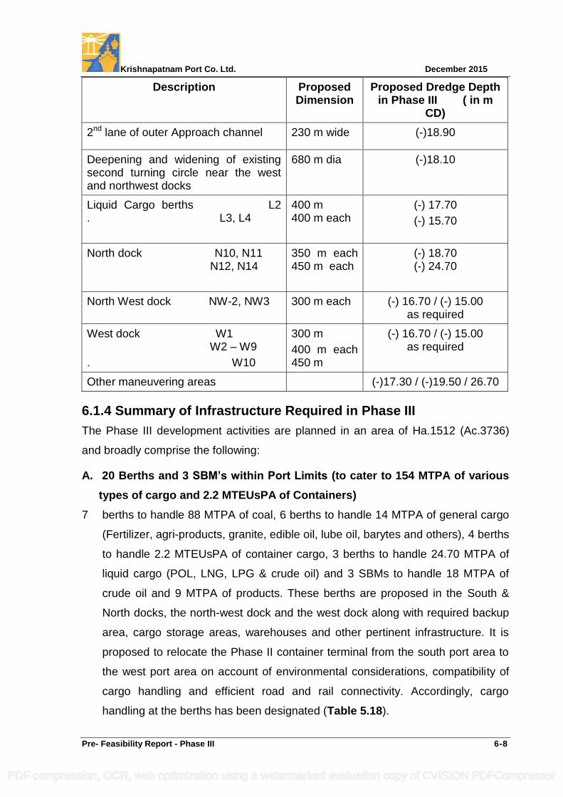
Krishnapatnam Port Co. Ltd. December 2015
Pre- Feasibility Report - Phase III 6-8
Description Proposed Dimension
Proposed Dredge Depth in Phase III ( in m
CD)
2nd lane of outer Approach channel 230 m wide (-)18.90
Deepening and widening of existing second turning circle near the west and northwest docks
680 m dia (-)18.10
Liquid Cargo berths L2 . L3, L4
400 m 400 m each
(-) 17.70
(-) 15.70
North dock N10, N11 . N12, N14
.
350 m each 450 m each
(-) 18.70 (-) 24.70
North West dock NW-2, NW3 300 m each (-) 16.70 / (-) 15.00 as required
West dock W1 . W2 – W9
. W10
300 m
400 m each 450 m
(-) 16.70 / (-) 15.00 as required
Other maneuvering areas (-)17.30 / (-)19.50 / 26.70
6.1.4 Summary of Infrastructure Required in Phase III
The Phase III development activities are planned in an area of Ha.1512 (Ac.3736)
and broadly comprise the following:
A. 20 Berths and 3 SBM’s within Port Limits (to cater to 154 MTPA of various
types of cargo and 2.2 MTEUsPA of Containers)
7 berths to handle 88 MTPA of coal, 6 berths to handle 14 MTPA of general cargo
(Fertilizer, agri-products, granite, edible oil, lube oil, barytes and others), 4 berths
to handle 2.2 MTEUsPA of container cargo, 3 berths to handle 24.70 MTPA of
liquid cargo (POL, LNG, LPG & crude oil) and 3 SBMs to handle 18 MTPA of
crude oil and 9 MTPA of products. These berths are proposed in the South &
North docks, the north-west dock and the west dock along with required backup
area, cargo storage areas, warehouses and other pertinent infrastructure. It is
proposed to relocate the Phase II container terminal from the south port area to
the west port area on account of environmental considerations, compatibility of
cargo handling and efficient road and rail connectivity. Accordingly, cargo
handling at the berths has been designated (Table 5.18).
PDF compression, OCR, web optimization using a watermarked evaluation copy of CVISION PDFCompressor
Krishnapatnam Port Co. Ltd. December 2015
Pre- Feasibility Report - Phase III 6-9
B. Dredging
About 63 million cum of dredging in soft soils for achieving required depths in the
navigable waterways and alongside Berths.
Out of the total dredging quantity, it is proposed to use about 29 million cum for
reclamation of port lands and the balance 34 million cum of dredge material is
proposed for disposal at the dumping ground identified in Phase II beyond (-) 20m
contour.
C. Straightening of Khandaleru Creek
Straightening of Khandaleru Creek by forming a straight cut across the existing sand
bar in Khandaleru Creek near the west port for development of west dock and
thereafter reclaim the meandering north and south arms of the creek (Ha.133.80) to
serve as back space required for the berths.
D. Shore Protection for reclamation area near South and North Breakwaters
It is proposed to construct suitably designed rubble mound structures of about 1300
m long on the southern side and 1000 m long on the northern side which would act
as shore protection for the accretion observed near coast at the land fall points of the
breakwaters and conserve the said area by reclaiming these areas to uniform level
by utilizing dredged sand. The sheltered areas (Ac. 41 on the southern side & Ac.
40 on the northern side) between the existing breakwater the shore protection
mound are proposed to be utilized for pipeline corridors for the LNG, LPG, POL &
Crude oil and to accommodate related essential control / safety installations and
allied infrastructure including breakwater maintenance facility by suitably reclaiming
the same with dredge sand.
E. Replacement of the existing mangroves
Mangroves existing in the project area would be replaced at suitable areas within the
proximity of the port.
PDF compression, OCR, web optimization using a watermarked evaluation copy of CVISION PDFCompressor
Krishnapatnam Port Co. Ltd. December 2015
Pre- Feasibility Report - Phase III 6-10
F. Changes in Water Bodies
Four ephemeral drains exist in the development area; one of them serving as an
agricultural drain and the rest as drainage path for the defunct salt pans. The
agricultural drain would be diverted and maintained. A culvert is proposed for one
drain in the south which is crossing the port boundary and meeting the Buckingham
Canal. The other two local drains would be reclaimed along with salt pans and the
fish ponds except the part of one drain being maintained for tidal exchange to the 9
acres of mangrove being protected.
G. Bridges
Development of two road (RB7 & RB22) and four railway bridges (RB10, RB10A,
RB11& RB11A) on Khandaleru Creek, one railway bridge (RB14) and four road
bridges (RB12, RB13, RB21 & RB 23) on Buckingham Canal, two road bridges
(RB19 & RB20) on drain / creek, modification of the existing bridge (EX1) on
Upputeru creek as Rail-Cum-Road Bridge and strengthening of 5 existing bridges /
culverts on Buckingham Canal (RB15, RB16, RB17, RB18 & EX2) to integrate the
Port’s operational area separated by creek system and to facilitate faster deployment
of heavy duty trucks and railways for transport of cargo to / from port and hinterland
as well as reduce smoke emissions from cargo trucks..
H. Operational Control Buildings
Two near corners of North dock (CB-1 & CB-2), One along western end of the
Northern Arm (CB-3), Two near corners of the North-West dock (CB-4 & CB-5), four
on the corners of the Western Dock (CB-6,CB-7,CB-8 & CB-9) and one near western
end of the Southern berthing front (CB-10).
I. Port Craft Jetty, Repair Dry Dock and Coast Guard Jetty
Development of two jetty’s 800 m long for Port Crafts and 200 m long Coast Guard
vessels, a Repair Dry Dock 150 m long, 40 m wide and 12.0 m depth with (-) 9.5
m sill level at entrance) with a 200 m long repair quay and another Repair dry dock
335 m in length, 65 m in width and 15.0 m in depth (with -12.5 m sill level at
entrance) with repair quay of 200 m long
PDF compression, OCR, web optimization using a watermarked evaluation copy of CVISION PDFCompressor
Krishnapatnam Port Co. Ltd. December 2015
Pre- Feasibility Report - Phase III 6-11
6.2 Non-Operational Area (Non Processing Area)
The non-operational area comprises of residential area, hospitals, training centers
and commercial establishments like banks, etc. An area of 20 acres is allotted for
institutional area like banks, etc and an area of 35 acres is provided for fuel storage
and other services. About 10 acres is allotted for residential bachelor
accommodation.
6.3 Green Belt
In Phase III, green belt development is required along the boundary of the western
port and also around the storages to be developed in Phase III.
As the area south of the west port is reserve forest land and also as the cargo
storage proposed in west port is for containers, the green belt width proposed along
the west port boundary is 50 m. A 20 m wide Greenbelt is proposed around the dry
bulk storages.
In addition, avenue plantation is proposed along the median and alongside the road.
It is also proposed to develop 13 ha of green pastures on the southern beach for
aesthetic up-gradation.
It is proposed to develop 152 ha of green belt in Phase III.
6.4 Social Infrastructure
The proposed Phase III expansion of Krishnapatnam Port is located within the limits
of the area sanctioned for the development of the port by GoAP. The proposed
Phase III development of the port does not involve any resettlement and
rehabilitation activity. Phase I & II developments of Krishnapatnam Port involved
resettlement and rehabilitation for which GoAP has already implemented appropriate
resettlement and rehabilitation plans. KPCL also voluntarily supplemented to the
R&R schemes under its CSR initiatives.
CSR activities implemented through CVR foundation in the neighbouring villages are
aimed at improving overall living standards in the neighbouring villages, catering to
the following aspects:
PDF compression, OCR, web optimization using a watermarked evaluation copy of CVISION PDFCompressor
Krishnapatnam Port Co. Ltd. December 2015
Pre- Feasibility Report - Phase III 6-12
o Housing,
o Education,
o Health,
o Protected water supply
o Imparting vocational skills – driving, welding,
o Women empowerment – tailoring, embroidery, pickle making, etc.
o Community services like old age homes, places of worship, community halls
and supply cooking gas
Under the CSR activities of the Krishnapatnam Port, CVR Foundation runs 27
schools in nearby villages and has established a hostel building in Nellore for the
students pursuing higher education i.e. from Intermediate to Post Graduate level
standard with free boarding & lodging facilities. It has also developed NAVANEETHA
PUBLIC SCHOOL, a school of international standard for the benefit of the local
population. It has Academic and a Hostel facility in an iconic building with a
total built-up area is over 65,000 Sft, complete with modern infrastructure
facilities.
Up to the year 2014-15, Krishnapatnam Port has undertaken CSR activities
amounting to Rs. 75.3 Crores including supplementing the R & R measures. Funds
are allocated for CSR activities annually. An amount of Rs 14.0 crores is budgeted
for the year 2015-16 towards CSR activities.
6.5 Connectivity (Traffic &Transportation Road/Rail/Water ways etc.)
6.5.1 Rail Double line electrified rail connectivity has been developed from Venkatachalam on
the main line to Krishnapatnam Port connecting the port with the Chennai-Howrah
trunk line.
6.5.2 Road
A four lane expressway was developed by R&B department from Venkatachalam on
NH-16 (old NH-5) to Krishnapatnam Port. It is feasible to widen the same to 6 lanes.
The developed connectivity with the port ensures quick movement of goods and
personnel. In view of the exclusive connectivity to the NH-16 which forms a part of
Golden quadrilateral the impact on the existing traffic in the region is minimal.
PDF compression, OCR, web optimization using a watermarked evaluation copy of CVISION PDFCompressor
Krishnapatnam Port Co. Ltd. December 2015
Pre- Feasibility Report - Phase III 6-13
Further, NHAI proposes to develop NH-16 as six lane road (from Ichapuram to Tada)
considering the future traffic.
6.5.3 Waterways
The waterway passing through Krishnapatnam Port is Buckingham Canal is under
the control of Inland Waterways Authority of India, which was developed for inland
navigation during the British regime. Presently it is defunct. The flow regime of
Buckingham Canal is preserved.
6.6 Drinking Water Management (Source & Supply of Water)
In Phase III, about 600 KLD of water is estimated for domestic purposes and 1900
KLD for dust suppression, plantation and fire-fighting purposes etc., totaling to 2500
KLD. The planned water consumption for Phase II is 2.5 MLD with about 400 KLD of
for domestic purposes. Thus, the total drinking / potable water demand would be
about 1.0 MLD and the overall water requirement shall be 5.0 MLD.
GoAP has allocated 1 MLD of potable water from the nearby Muthukuru reservoir in
terms of the Concession Agreement and laying of pipe lines from Muthukuru
Reservoir to the port boundary is on hand. Irrigation department of GoAP has also
permitted the drawal of 4 MLD of water from the nearby Nakkala Kalava irrigation
drain.
The domestic water requirement of 1.0 MLD would be met from the Muthukuru
Reservoir supplies and the requirement of 4.0 MLD towards dust suppression,
plantation, firefighting etc., would be drawn from Nakkala Kalava irrigation drain.
Necessary additional storage tanks, pump houses and pipelines will be provided as
required.
Rainwater harvesting pits are provided to recharge ground water.
6.7 Sewerage System
One 300 KLD STP is under operation. Additional STPs, with a total of about
700 KLD are proposed be established in the port to cater to the sewage that would
be generated from the Phase III domestic demand. The treated effluent shall be
recycled for dust suppression and plantation purposes.
PDF compression, OCR, web optimization using a watermarked evaluation copy of CVISION PDFCompressor
Krishnapatnam Port Co. Ltd. December 2015
Pre- Feasibility Report - Phase III 6-14
Isolated buildings will be provided with septic tanks and soak pits.
6.8 Industrial Waste Management
As a port is not an industry no industrial wastes are generated. Leachate and runoff
from coal storage areas shall be routed through garland drains and collection pits
into guard ponds and shall be recycled for dust suppression.
6.9 Solid Waste Management
The solid waste from the utilities like canteen are being segregated as biodegradable
and non-biodegradable waste and collected separately by providing bins at
respective places.
About 90% of the waste which is likely to be generated at the port amounting to
about 900 kg/day is biodegradable and would be subjected to composting for use as
manure for green belt within the port.
About 10% of the waste likely to be generated at the port is non-biodegradable like
plastic, shall be collected and disposed through approved vendors of APPCB duly
following the norms. The non-biodegradable waste is about 100kg/day.
The composting site shall be located at a suitable location.
6.10 Power Requirement & Supply / Source
The power requirement is about 45 MW for the Phases I & II and it would increase to
130 MW for the Phase III. GoAP has agreed to provide power supply as an external
infrastructure, in terms of the Concession Agreement. To meet power requirements,
a 132/33 kV substation was built by KPCL in the port limits and APTRANSCO has
provided power supply of 45 MW, from the grid to meet the demand of Phases I & II.
Additional power supply for Phase-III would be provided by the GoAP from the
APTRANSCO’s power grid. Five additional sub-stations are proposed within the port
boundary to cater to the Phase III power requirement.
However DG sets are proposed as back-up for safety lighting and safety equipment
during power failures
PDF compression, OCR, web optimization using a watermarked evaluation copy of CVISION PDFCompressor
Krishnapatnam Port Co. Ltd. December2015
Pre- Feasibility Report -Phase III 7-1
7 REHABILITATION AND RESETTLEMENT (R&R) PLAN
GoAP is the owner of the entire land earmarked for the development of
Krishnapatnam Port and the same is being transferred on lease basis to KPCL in
terms of the Concession Agreement.
The proposed Phase III development of the port does not involve any
resettlement and rehabilitation activity.
The Phase I & II developments of the Krishnapatnam Port involved resettlement of
four villages and local fishermen for which GoAP sanctioned R & R measures
amounting to Rs 58.06 Crores for the project affected families (PAFs) in the villages.
GoAP has rehabilitated them by building 500 houses. In addition to the GoAP’s
share, Krishnapatnam Port have voluntarily supplemented the R& R schemes by
development of social infrastructure like improved housing, road, water supply,
power supply, community facilities, along with green belt zones in the resettlement
areas. Krishnapatnam Port is committed to balanced and sustainable development in
harmony with the surrounding environment and has taken up several socio-
economic growth initiatives besides other clean and green measures as part of CSR
initiatives in line with applicable guidelines being implemented through CVR
foundation.
The community infrastructure has improved also on account of CSR activities being
undertaken by the port in the neighbouring villages.
Up to the year 2014-15, Krishnapatnam Port has undertaken CSR activities
amounting to Rs. 139.70 Crores including supplementing the R & R measures.
Funds are allocated for CSR activities annually. An amount of Rs 10.70 crores is
budgeted for the year 2015-16 towards CSR activities.
PDF compression, OCR, web optimization using a watermarked evaluation copy of CVISION PDFCompressor
Krishnapatnam Port Co. Ltd. December 2015
Pre- Feasibility Report -Phase III 8-1
8 PROJECT IMPLEMENTATION SCHEDULE AND COST
ESTIMATES
8.1 General
The implementation schedule aims at completing the proposed development of
Phase III facilities of Krishnapatnam Port within a fixed time frame and is prepared
considering the various activities involved in the project and duration of each activity.
8.2 Proposed Development
The main components for the Phase III development of Krishnapatnam Port
comprises of:
Pre-development Activities
Field surveys and investigations
o Topographic surveys
o Geotechnical investigations (terrestrial)
o Oceanographic surveys
o HTL - LTL & CRZ demarcation
Baseline environment survey (marine and terrestrial) & EIA Report
Environment and CRZ clearance from MoEF
Detailed Project Report
Technical closure
Financial closure
Development Activities
Area development
Capital dredging and reclamation
Construction of berths
Development of cargo storage areas and ware houses
On-shore infrastructure including supply and installation of material
handling equipment, conveyors, pipelines etc.
Internal road and railway networks, water supply and drainage
Power supply, switch gear and area illumination
Services, utilities, environmental works
Operational, functional, administrative, welfare and amenities buildings.
PDF compression, OCR, web optimization using a watermarked evaluation copy of CVISION PDFCompressor
Krishnapatnam Port Co. Ltd. December 2015
Pre- Feasibility Report -Phase III 8-2
8.3 Time Schedule
Following pre-development activities are expected to take about 12 months time
upon approval of the TOR by MoEF:
Field surveys and investigations
Environmental and CRZ Clearance by MoEF
CFE by APPCB
Technical Closure and Financial Closure are to be achieved prior to the
commencement of Phase III development of the port. These activities would require
about 12 to 18 months for completion and shall be taken simultaneously with the pre-
development activities.
Implementation of the envisaged Phase III Development i.e., port construction is
expected to take about 60 months after grant of CRZ & EC Clearance by MoEF.
The project implementation schedule for the development activities is depicted by a
bar chart in Drawing No. KP/PH-III/PFR/17.
Details of the main development activities / items identified are given below.
8.3.1 Civil Works
8.3.1.1 Dredging and Reclamation
The estimated quantity of capital dredging is about 63 million cum.
About 29 million cum of the dredged material will be used for reclamation and 34
million cum is proposed to be disposed off at the approved disposal area beyond (-)
20 m CD. The time estimate for completing the dredging and reclamation is about 54
months.
8.3.1.2 Berth Construction
During Phase III, it is proposed to develop 20 berths within the protected water areas
of the port comprising of 7 berths for dry bulk cargo, 6 berths for general cargo, 4
berths for container cargo and, 3 berths for liquid cargo in addition to the 3 SBMS for
liquid cargo in deep waters within port limits. The quay wall for all dry bulk, general
cargo and container cargo berths shall be relieving platform type construction
comprising of a substructure of RCC diaphragm wall with combination of vertical and
raker piles and an RCC deck super structure.
PDF compression, OCR, web optimization using a watermarked evaluation copy of CVISION PDFCompressor
Krishnapatnam Port Co. Ltd. December 2015
Pre- Feasibility Report -Phase III 8-3
Liquid cargo berths shall be dolphin type structures formed with RCC pile
substructure and RCC deck superstructure connected with walkways supported on
RCC piles. These berths will be connected by means of piled approaches to the
respective breakwaters on the Southern & Northern sides. Construction of all the
berths will be completed in about 45 months.
The SBMs comprises of readily fabricated bought out steel buoy with standard
anchorage & evacuation pipe system.
8.3.1.3 Shore Protection on the windward side of the Breakwaters
Development of rubble mound shore protection structures 1300 m & 1000 m long are
proposed windward of the existing South & North breakwater respectively.
The rubble mound breakwater shall be suitable designed and formed with rock
under-layers protected by armour layer. The placement of rock / quarry run will be
progressed by end on dumping method. A 0.5 m thick quarry run i.e., filter layer will
be placed over the bed before the placement of core material. It is envisaged the
construction of rubble mound breakwater can be completed in 36 months.
8.3.2 Mechanical and Electrical Works
Mechanical and electrical works relate to cargo handling equipment, electrical
system, control system, communication system etc. The estimated time for
completion of these works is about 54 months.
8.3.3 Onshore Development
8.3.3.1 Buildings
A suitable number of buildings as per their functional requirements shall be provided
at the port like administrative building, warehouses, port operation building, canteen,
gate house, fire station building, sub-station with control room etc. The total
construction of these buildings will take 45 months.
8.3.3.2 Stockyards
Stockyards are proposed for stacking of coal with suitable ground improvement and
drainage facilities. The estimated time for completion of these works is about 46
months.
PDF compression, OCR, web optimization using a watermarked evaluation copy of CVISION PDFCompressor
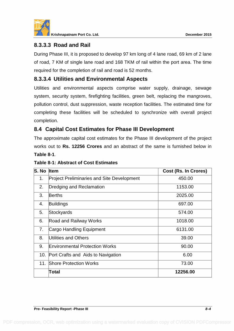
Krishnapatnam Port Co. Ltd. December 2015
Pre- Feasibility Report -Phase III 8-4
8.3.3.3 Road and Rail
During Phase III, it is proposed to develop 97 km long of 4 lane road, 69 km of 2 lane
of road, 7 KM of single lane road and 168 TKM of rail within the port area. The time
required for the completion of rail and road is 52 months.
8.3.3.4 Utilities and Environmental Aspects
Utilities and environmental aspects comprise water supply, drainage, sewage
system, security system, firefighting facilities, green belt, replacing the mangroves,
pollution control, dust suppression, waste reception facilities. The estimated time for
completing these facilities will be scheduled to synchronize with overall project
completion.
8.4 Capital Cost Estimates for Phase III Development
The approximate capital cost estimates for the Phase III development of the project
works out to Rs. 12256 Crores and an abstract of the same is furnished below in
Table 8-1.
Table 8-1: Abstract of Cost Estimates
S. No Item Cost (Rs. In Crores)
1. Project Preliminaries and Site Development 450.00
2. Dredging and Reclamation 1153.00
3. Berths 2025.00
4. Buildings 697.00
5. Stockyards 574.00
6. Road and Railway Works 1018.00
7. Cargo Handling Equipment 6131.00
8. Utilities and Others 39.00
9. Environmental Protection Works 90.00
10. Port Crafts and Aids to Navigation 6.00
11. Shore Protection Works 73.00
Total 12256.00
PDF compression, OCR, web optimization using a watermarked evaluation copy of CVISION PDFCompressor

DRAWINGS
PDF compression, OCR, web optimization using a watermarked evaluation copy of CVISION PDFCompressor