Embed Size (px)
Citation preview

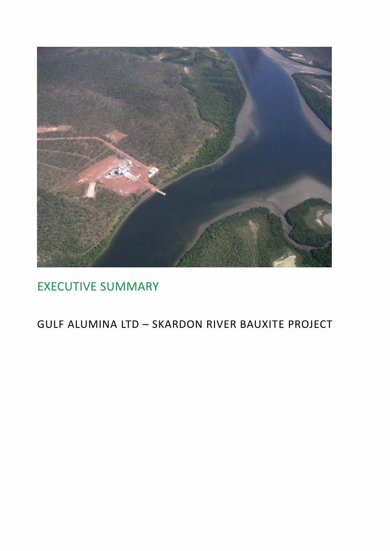
EXECUTIVE SUMMARY
GULF ALUMINA LTD – SKARDON RIVER BAUXITE PROJECT
Skardon River Bauxite Project Executive Summary
Page 1-i
TABLE OF CONTENTS
ES1.1 Project Overview and Proponent ........................................................................1-1 ES1.2 Purpose of the Environmental Impact Statement ................................................1-1 ES1.3 Economic and Social Benefits ..............................................................................1-1 ES1.4 Project Location .................................................................................................1-2 ES1.5 Project Description .............................................................................................1-4 ES1.6 Approvals Process ..............................................................................................1-7 ES1.7 Public Consultation ............................................................................................1-7 ES1.8 Water Management ...........................................................................................1-7 ES1.9 Rehabilitation and Decommissioning ..................................................................1-8 ES1.10 Non-mining Waste .............................................................................................1-9 ES1.11 Climate ..............................................................................................................1-9 ES1.12 Geology, Topography and Soils ......................................................................... 1-10 ES1.13 Land Use .......................................................................................................... 1-11 ES1.14 Land Contamination ......................................................................................... 1-12 ES1.15 Water Bodies and Water Quality ...................................................................... 1-13 ES1.16 Hydrology and Hydrogeology ............................................................................ 1-14 ES1.17 Flooding ........................................................................................................... 1-16 ES1.18 Terrestrial Ecology ............................................................................................ 1-16 ES1.19 Aquatic Ecology and Stygofauna ....................................................................... 1-18 ES1.20 Coastal Processes ............................................................................................. 1-19 ES1.21 Marine Ecology ................................................................................................ 1-20 ES1.22 Air Quality and Greenhouse Gases .................................................................... 1-22 ES1.23 Noise and Vibration .......................................................................................... 1-23 ES1.24 Landscape and Visual Amenity .......................................................................... 1-24 ES1.25 Transport and Maritime Operations .................................................................. 1-25 ES1.26 Hazards and Safety ........................................................................................... 1-26 ES1.27 Cultural Heritage and Native Title ..................................................................... 1-27 ES1.28 Social and Economic Impacts ............................................................................ 1-28 ES1.29 Matters of National Environmental Significance ................................................ 1-29 ES1.30 Cumulative Impacts .......................................................................................... 1-29 ES1.31 Conclusion ....................................................................................................... 1-30
Figures
Figure ES1-1 Project Location, Mining Leases and Activity Areas ................................................... 1-3 Figure ES1-2 Proposed Project Layout ............................................................................................ 1-6
Skardon River Bauxite Project Executive Summary
Page 1-1
ES1. EXECUTIVE SUMMARY
ES1.1 Project Overview and Proponent
Gulf Alumina Ltd (Gulf Alumina) is a public company registered on 23 February 2004 in Sydney, NSW to explore and develop bauxite deposits in and around Australia.
Gulf Alumina is the proponent for the proposed Skardon River Bauxite Project (the Project). The Project involves mining of a bauxite ore body of 50 million tonnes (Mt) in the Cape York region of Queensland. The planned mine production rate would initially be 3 million tonnes per annum (Mtpa) and would rise to 5 Mtpa subject to market conditions. The operational Project life is expected to be 10 years, with a construction period of approximately 1 year and post mining decommissioning and final rehabilitation period.
ES1.2 Purpose of the Environmental Impact Statement
The purpose of this Environmental Impact Statement (EIS) document is to provide information to support the Project’s environmental authority (EA) amendment application under the Environmental Protection Act 1994 (EP Act) and Referral under the Environment Protection and Biodiversity Conservation Act 1999 (EPBC Act).
ES1.3 Economic and Social Benefits
The social and economic benefits of the Project are summarised as follows:
Capital expenditure of approximately $61 million will be invested into the economy.
Operational expenditure of approximately $134 million per annum will be invested into the economy.
Approximately 160 direct jobs and many more indirect jobs will be created during operations.
Approximately 100 direct jobs and many more indirect jobs will be created during construction.
Royalties of approximately $325 million over the life of the Project will be generated.
Taxes of approximately $434 million over the life of the Project will be generated.
Indigenous groups will receive benefits under the current traditional owner agreement.
Indigenous landowners will receive a share of mining lease royalty payments.
The Port of Skardon River (as operated by Ports North) will be further developed.
Infrastructure (airstrip, accommodation, dams, roads and Port) will be upgraded or developed. In
agreement with the landowners (traditional owners), these may be retained to improve the
functionality of the land.
Commitments by the proponent to assist with land management type activities (e.g. weed and pest
management and fire management) will be implemented.
Economic stimulation generated as a result of wages and additional demand for goods and services is expected to have beneficial effects at the local level. Revenue generated for the State and Federal government in the form of taxes and royalties will assist in the funding of a wide range of services to the benefit of the community. The Project is expected to have a beneficial impact on Indigenous people residing in the local area and Cape York region through the provision of increased business opportunities, employment, education and training opportunities.

Skardon River Bauxite Project Executive Summary
Page 1-2
ES1.4 Project Location
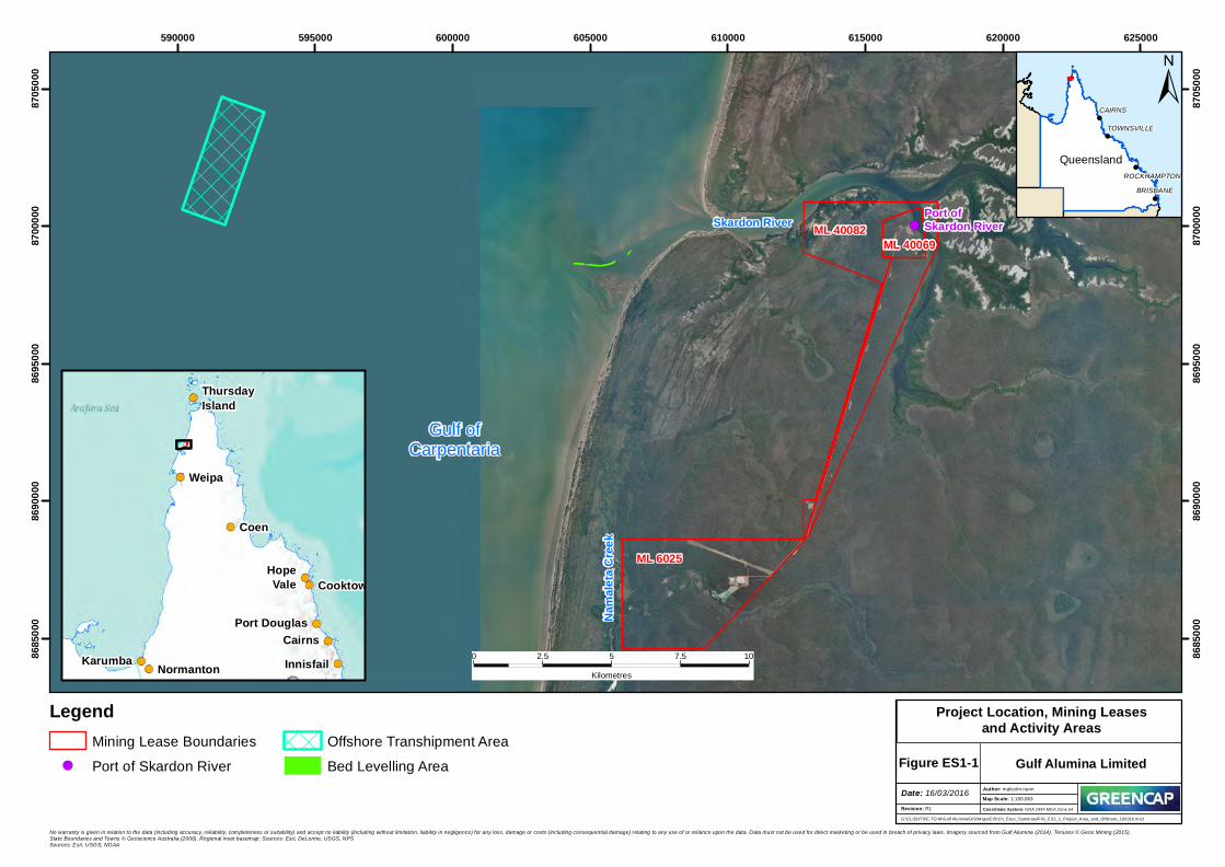
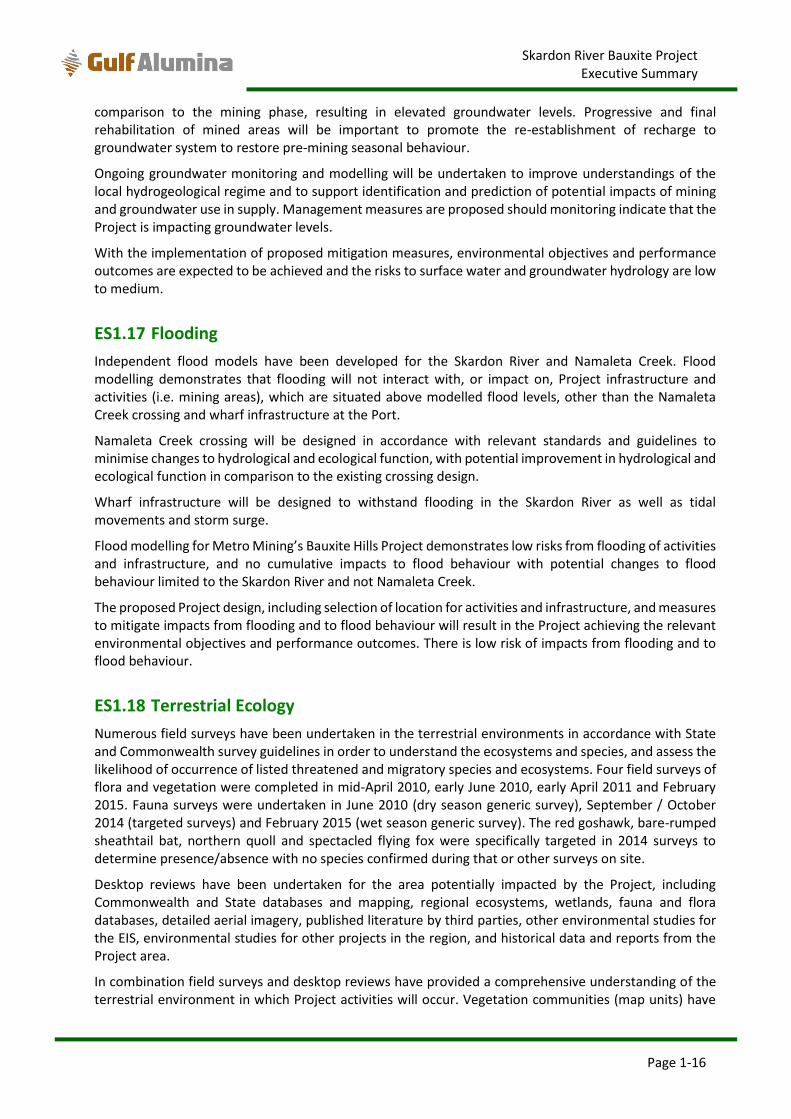
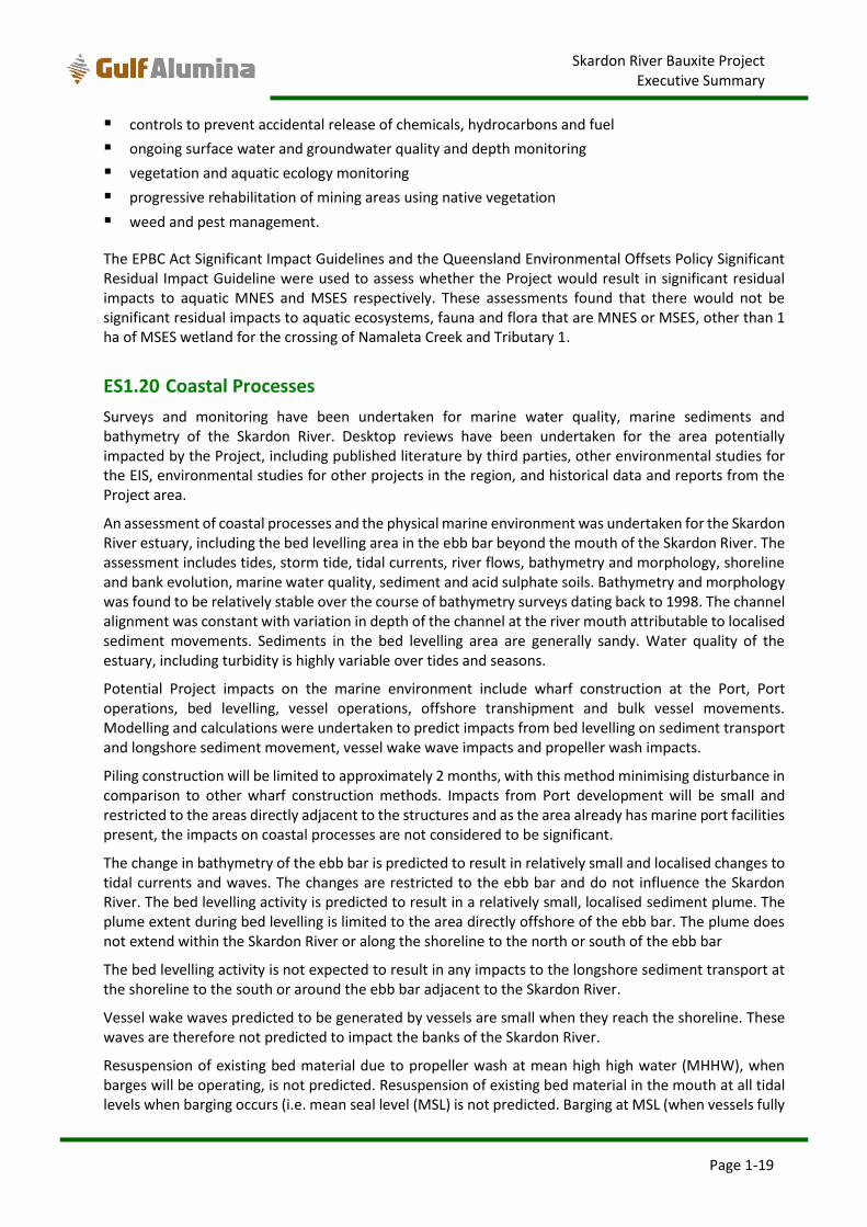
The Project will be located on Cape York Peninsula, approximately 90 km north of Weipa. The relevant mining tenures are granted mining leases (MLs) 6025, ML 40069 and ML 40082. The Port of Skardon River is within the Project’s mining leases. Some Project activities will occur outside of the mining leases such as barging of bauxite on the Skardon River, bed levelling and offshore transhipment. The Project location, mining leases and activity areas is shown in Figure ES1-1.
!(Skardon River ML 40082ML 40069
Port ofSkardon River
ML 6025
Gulf ofCarpentaria
Nama
leta C
reek
590000 595000 600000 605000 610000 615000 620000 62500086
8500
0
8685
000
8690
000
8690
000
8695
000
8695
000
8700
000
8700
000
8705
000
8705
000
!
!
!
!
ROCKHAMPTONBRISBANE
CAIRNS
TOWNSVILLE
Queensland
No warranty is given in relation to the data (including accuracy, reliability, completeness or suitability) and accept no liability (including without limitation, liability in negligence) for any loss, damage or costs (including consequential damage) relating to any use of or reliance upon the data. Data must not be used for direct marketing or be used in breach of privacy laws. Imagery sourced from Gulf Alumina (2014). Tenures © Geos Mining (2015).State Boundaries and Towns © Geoscience Australia (2006). Regional inset basemap: Sources: Esri, DeLorme, USGS, NPSSources: Esri, USGS, NOAA
±
Figure ES1-1 Gulf Alumina Limited
LegendMining Lease Boundaries
!( Port of Skardon RiverOffshore Transhipment AreaBed Levelling Area
0 2.5 5 7.5 10Kilometres
G:\CLIENTS\E-TO-M\Gulf Alumina\GIS\Maps\EIS\Ch_Exec_Summary\FIG_ES1_1_Project_Area_and_Offshore_160316.mxd
Revision: R1
Date: 16/03/2016 Author: malcolm.nunn1:150,063Map Scale:
Coordinate System: GDA 1994 MGA Zone 54
Project Location, Mining Leasesand Activity Areas
Cooktown
Weipa
InnisfailCairns
Karumba Normanton
ThursdayIsland
Coen
HopeVale
Port Douglas
Skardon River Bauxite Project Executive Summary
Page 1-4
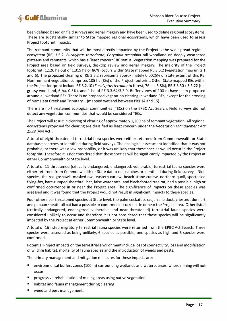
ES1.5 Project Description
The Project involves the construction and operation of an open cut bauxite mine in Western Cape York Peninsula. The Project involves mining a bauxite ore body of around 50 million tonnes (Mt) and is anticipated to initially produce 3 million tonnes per annum (Mtpa) bauxite suitable as direct shipping ore (DSO), which is expected to rise to 5 Mtpa subject to market conditions.
The DSO bauxite mining method involves vegetation clearing and grubbing, harvesting topsoil and subsoil, mining bauxite, placing mined subsoil on mined pit floor, placing harvested topsoil on subsoil and rehabilitating mined areas. The bauxite within the mining leases is less than 3 m thick, with an average DSO thickness of 1.7 m, and does not extend more than 6 m below the surface. Conventional open cut mining will be carried out after removing the topsoil and subsoil. Mining will occur 24 hours per day, 7 days per week. Mining of DSO bauxite is planned to occur during the dry season with shut down during heavy rain periods of the wet season, approximately 3 months from January to March.
DSO does not require beneficiation of the bauxite and hence beneficiation and associated tailings management are not part of the Project. The option for DSO bauxite therefore results in lower environmental impact than beneficiation of bauxite by avoiding tailings management and associated additional water and energy requirements.
The bauxite ore will be mined and transported via existing, upgraded haul roads to a crushing and stock pile facility at the Port of Skardon River. The bauxite product will be barged to bulk carrier vessels in deep water approximately 15 km beyond the mouth of the river for export. Construction is planned to commence in 2016 with bauxite mining and shipping in 2017 after the wet season period. For the purpose of feasibility study mine planning, it is assumed that mining commences in April 2017.
Life of Project activities and infrastructure that form part of the EIS assessment for the Project include:
A new wharf / barge loading facility within the Project’s existing mining leases and the gazetted Port
of Skardon River, constructed using piles and dolphins.
Barging of bauxite to the offshore transhipment location in deep water approximately 15 km offshore
from the Skardon River mouth, and transfer from barges to bulk carriers.
Bulk carrier movements with Australian waters.
Bed-levelling at the mouth of Skardon River to a depth of approximately 2.2 m below lowest
astronomical tide (LAT). Bed levelling would involve underwater reprofiling of shallow areas at the
seaward extent of the Skardon River mouth by pushing the crests of sand banks into deeper gutters.
No dredging is proposed; however, annual maintenance bed levelling is likely to be required.
Upgrade of the existing boat ramp and jetty infrastructure at the Port to improve access for vessel
supply of fuel, consumables, materials and site equipment.
New bauxite ore dump facility, mobile crushers, conveyor belt system and bauxite product stockpile
facility, all adjacent to the Port of Skardon River landing.
New workshop, warehouse, administration and crib room at the Port of Skardon River.
Upgrade of the existing bulk fuel storage, new fuel transfer pipeline, diesel transfer tanks and export
waste storage at the Port of Skardon River.
Use of existing landfill and a new landfill with leachate management, for limited waste disposal.
Upgrade of the existing 15 km north-south haul road from the Port to the former wet plant area; a
new haul road system surrounding the kaolin mine overburden piles, upgrade of the crossing of
Namaleta Creek and an additional 1.5 km of haul roads south of Namaleta Creek.
Temporary branch haul roads would be used to link with the existing haul road.
Skardon River Bauxite Project Executive Summary
Page 1-5
Upgrade of the existing accommodation camp from 50 beds to 150 beds for the construction
workforce and maintained for mining operation, and upgrade of the sewage treatment system.
Use of the existing airstrip and relocated airstrip later in mine life, primarily for transport of workers.
A process water pumping station at the existing kaolin mine water storage pits with existing pipeline
to transfer water to water storage tanks at the Port of Skardon River. This pipeline will run adjacent
to the existing north- south haul road.
Installation of a new sediment pond, and retention of the existing sediment pond for stormwater run-
off from infrastructure and stockpile areas at the Port of Skardon River.
Power will be supplied by three 1MW generators fitted on semi-trucks.
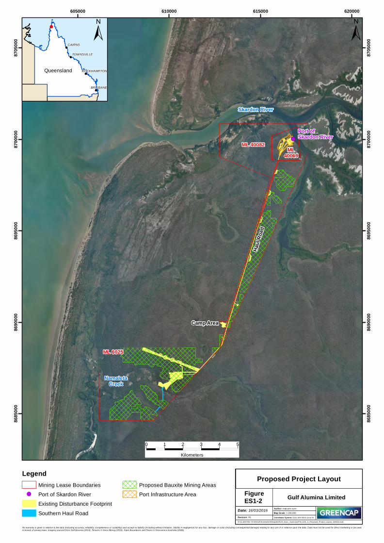
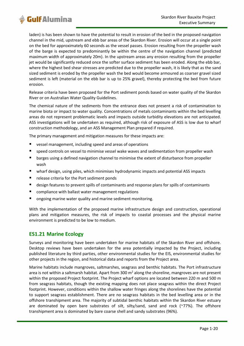
The proposed Project layout, with all mining areas and the Port infrastructure area is shown in Figure ES1-2.
Water demand, water supply and mine site water management are described in Section ES1.8. The annual water requirements for dust suppression, watering haul roads and plant and equipment washdown would be sourced from the existing kaolin mine water storages and shallow groundwater aquifers.
The offshore transhipment would occur in a defined area where bulk carriers (e.g. Panamax ships) will anchor. Barges will anchor adjacent to the bulk carriers for loading of bauxite ore.
Two barges, with a capacity of about 4,000 to 7,000 t per barge, will transfer bauxite ore to the bulk carriers, which will have an approximate capacity of 75,000 deadweight tonnes (dwt). Barges would work 24 hours (although crossing of the Skardon River mouth would be limited to approximately 18 hours of the day to avoid low tide), 7 days a week with a loading rate up to 2,000 tonnes/hour, for approximately 40 weeks per annum (i.e. excluding the wet season). At a bauxite production rate of 5 Mtpa, this will result in approximately 1.5 bulk carrier shipping movement per week, or 65 to 70 bulk vessel movements per annum.
It is expected that an average of 100 people will need to be accommodated during the bauxite infrastructure construction period of 30 weeks with a maximum workforce of 120 people. The Project would require approximately 160 employees during operation. Employees will be on a shift roster and hence not all employees will be at site at any one time. Employees would be accommodated in the upgraded accommodation camp during the construction and the mining operation phases. The Project workforce will be transported to the site by air and will be accommodated in the camp on the Project area. The workforce will be 100% fly in fly out (FIFO), including from nearby areas such as Weipa and Mapoon, as it is not practical for the workforce to access the Project by road.
!(
ML40069
ML 6025
ML 40082
Port ofSkardon River
Skardon River
NamaletaCreek
Camp Area
Haul
Road
605000 610000 615000 62000086
8500
0
8685
000
8690
000
8690
000
8695
000
8695
000
8700
000
8700
000
8705
000
8705
000±
FigureES1-2
LegendMining Lease Boundaries
!( Port of Skardon RiverExisting Disturbance FootprintSouthern Haul Road
Proposed Bauxite Mining AreasPort Infrastructure Area
G:\CLIENTS\E-TO-M\Gulf Alumina\GIS\Maps\EIS\Ch_Exec_Summary\FIG_ES1_2_Proposed_Project_Layout_160316.mxd
Revision: R1
Date: 16/03/2016 Author: malcolm.nunn1:100,000Map Scale:
Coordinate System: GDA 1994 MGA Zone 54
Proposed Project Layout
0 1 2 3 4 5Kilometers
Gulf Alumina Limited
!
!
!
!
Queensland
CAIRNS
BRISBANE
TOWNSVILLE
ROCKHAMPTON
±
No warranty is given in relation to the data (including accuracy, reliability, completeness or suitability) and accept no liability (including without limitation, liability in negligence) for any loss, damage or costs (including consequential damage) relating to any use of or reliance upon the data. Data must not be used for direct marketing or be used in breach of privacy laws. Imagery sourced from Gulf Alumina (2014). Tenures © Geos Mining (2015). State Boundaries and Towns © Geoscience Australia (2006).
Skardon River Bauxite Project Executive Summary
Page 1-7
ES1.6 Approvals Process
The existing mining leases are subject to an existing EA. This EA relates to mining of kaolin on the mining leases, which has ceased. On 20 January 2014, the Department of Natural Resources and Mines (DNRM) approved the existing mining leases to include mining bauxite. Gulf applied for an amendment for bauxite mining within the existing mining leases in March 2014 as the current EA only allows for mining kaolin and operating an associated kaolin plant. The Department of Environment and Heritage Protection (EHP) decided that the proposed amendment was a major amendment under sections 228 and 229 of the EP Act. On 19 May 2014, EHP notified Gulf that the amendment application required assessment by EIS.
In May 2015, Gulf proposed a change to the EA amendment application under Sections 236 – 238 of the EP Act to include additional bauxite resources. In May 2015, EHP determined that the proposed changes would be assessed as part of this EIS.
The proposed Project was referred on 14 August 2014 to the Commonwealth Department of the Environment (DoE) (EPBC 2014/7305). On 11 September 2014, the Commonwealth Government Minister for the Environment determined the proposed Project to be a controlled action under the Commonwealth EPBC Act. The controlling provisions are sections 18 and 18A (listed threatened species and communities), 20 and 20A (listed migratory species) and 23 and 24A (Commonwealth marine areas). On 18 February 2015 DoE approved an application to vary the original Referral to include resource extraction within ML 6025 south of Namaleta Creek. On 22 April 2015, DoE approved an application to vary the original Referral to increase the depth of bed levelling and the volume of material to be transferred by bed levelling.
Gulf submitted an Initial Advice Statement (IAS) and the draft Terms of Reference (ToR) for the Project’s EIS in September 2014. Following Gulf’s responses to the comments received on the draft ToR (under Section 45 of the EP Act), the final ToR was approved on 15 January 2015.
The Project will be assessed under the bilateral agreement between the Commonwealth and the State of Queensland using the EIS prepared under the EP Act.
Approvals will be required under the Sustainable Planning Act 2009 for a tidal works permit for the bed levelling activities including initial bed levelling and subsequent maintenance bed levelling within the defined navigation channel.
ES1.7 Public Consultation
Consultation has been undertaken by Gulf Alumina with key Project stakeholders. Consultation occurred with a wide group of Traditional Owner groups during kaolin mine operations and as part of native title negotiations. Statutory and non-statutory consultation has continued as part of the EIS process with Traditional Owners, native title groups and a wide range of government stakeholders, local bodies and regional bodies. Consultation has informed the EIS process and studies. Gulf is committed to ongoing consultation with stakeholders through statutory and non-statutory processes, and to the implementation of a stakeholder management system, including issues and complaints resolution.
ES1.8 Water Management
Water management for mine site involves managing runoff from the following mine domains:
mine pits
Port infrastructure area
other infrastructure and activities (e.g. construction activities, haul roads, limited soil stockpiles).
Skardon River Bauxite Project Executive Summary
Page 1-8
During operational periods, it is intended that rainfall runoff entering the pit will be drained internally and contained within the pit, to be lost as evaporation and as recharge to local aquifers. The bauxite pits are located at the top of the local catchments and hence external catchments reporting to the pits will be minimal. Based on modelling of runoff and sediment volumes, in-pit sediment ponds will occupy a minor portion of each pit and the pit itself will act to capture any runoff should the sediment basins overtop.
One existing and one proposed sediment pond will be required at the Port infrastructure area to capture runoff from disturbance areas, including the bauxite stockpile, paved areas and haul roads. A preliminary assessment in accordance with the Manual for Assessing Consequence Categories and Hydraulic Performance of Structures (EHP, 2013) has determined that Port area sediment ponds are not regulated structures.
Operational measures have been proposed for the ongoing, effective functioning of water management infrastructure.
A water balance for the Project has been developed. Water demand is driven by dust suppression, bauxite moisture content requirements, vehicle washdown, potable water and construction water. Maximum demand is estimated as 1,653 m3/d (predominantly for dust suppression estimated as 1,177 m3/d), which occurs annually towards the end of the dry season. There is considerable seasonal variability in water demand, particularly in the larger demands related to dust control on haul roads and in the product stockpile.
A water supply strategy has been proposed which makes use of existing water supply sources, namely the existing kaolin mine water storages (581 m3/d) and existing shallow aquifer bores in the Namaleta Creek and Lunette aquifers (670 m3/d). These existing supply sources are not predicted to meet the required demand and hence six additional shallow aquifer bores (490 m3/d) are proposed, with three bores near the Port area, two in the Lunette aquifer and one in the Namaleta Creek aquifer.
Water supply is not proposed from other sources such as the Great Artesian Basin (GAB) or from the construction of dams.
There is opportunity to reduce demand or increase supply, and hence reduce the number of new shallow aquifer bores required, by using water collected in sediment ponds or using dust suppressant binding agents on roads.
ES1.9 Rehabilitation and Decommissioning
Geological, soils and landform data for the Project were gathered for the Project area to inform rehabilitation objectives and strategies for the various mine domains. These were based on the guidelines ‘Rehabilitation requirements for mining projects’ (EHP, 2014) and the ‘Technical Guidelines for the Environmental Management of Exploration and Mining in Queensland’ (DME, 1995).
A Rehabilitation Management Plan (RMP) will be developed to ensure that land disturbed by mining operations is effectively rehabilitated such that:
the agreed post-mining land use is achieved
the site is stable, non-polluting and safe to humans and animals
stable environmental conditions are established which are able to be sustained
all relevant statutory requirements are complied with.
Progressive rehabilitation will occur throughout the life of the Project. Decommissioning and final rehabilitation of areas used for mining will be outlined in a Mine Closure Plan (MCP) and specific rehabilitation completion criteria, indicators and monitoring methods, will be provided in the RMP. Rehabilitation of each mine domain will occur on a staged basis over a number of years.
Skardon River Bauxite Project Executive Summary
Page 1-9
On the completion of mining, the following treatments will be undertaken:
Infrastructure will be removed and dismantled where required unless Traditional Owners requests
otherwise.
Vegetation cover will be restored and land will be returned to its agreed post-mining land use native
vegetation).
Erosion and sediment control structures will be constructed to maintain topsoil cover, landform
stability and prevent sedimentation of waterways.
Contaminated land will be remediated and assessed for any potential future contamination issues.
Rehabilitated areas will be monitored in order to identify any areas in need of maintenance at an early stage and any areas not responding to rehabilitation methods will be addressed in accordance with the RMP. Following mine closure in accordance with the MCP and RMP, all rehabilitation goals and objectives are expected to be achieved.
ES1.10 Non-mining Waste
Non-mining waste streams which are likely to be generated during the construction, operation, rehabilitation and decommissioning phases of the Project have been identified and potential impacts on relevant environmental values described.
Measures are proposed to manage those wastes to ensure that regulatory requirements and identified objectives and criteria for waste management are addressed and options for waste treatment and minimisation are identified.
Opportunities will be sought to reduce, reuse or recycle all non-mining waste streams. Regulated wastes will be tracked and transferred off-site by ship to an appropriately licensed waste disposal facility. Non-regulated wastes will be disposed of to an on-site landfill with leachate management system. Bunds will be constructed around the perimeter of the landfill to divert surface flows away from the pit. When a landfill cell has attained maximum storage capacity, it will be capped with bauxite waste, kaolin clay overburden material and topsoil, and revegetated.
Sewage will be treated on-site and treated effluent will be irrigated to land subject to contaminant release limits. A wet weather storage pond will provide a back-up effluent storage. Biosolids in the sewage treatment system tanks will be remediated on the bioremediation pad.
Waste management strategies have been proposed to manage wastes in accordance with the waste management hierarchy, minimise environmental harm and to ensure proper storage containment and disposal of the waste streams identified where reuse and recycling are not available. A detailed Waste Management Plan (WMP) will be developed and will form part of the Project’s overall environmental management systems.
With the appropriate management, non-mining waste streams are expected to have a low risk of impact on environmental values.
ES1.11 Climate
Assessment of current climate information available for the Project region reveals the following:
The Project area experiences a tropical climate characterised by high rainfall in the wet season
(December to March) that is variable between years, depending on the influence of tropical lows
(cyclones).
The Project region experiences hot, humid and wet conditions during the wet season.
Skardon River Bauxite Project Executive Summary
Page 1-10
Temperatures are relatively consistent during the entire year with a marginally cooler dry season
between May and September. Maximum temperatures are experienced in the months of October
and November prior to the wet season.
Winds experienced for the region are predominantly from the east and south east with approximately
65% of the annual winds recorded from these sectors.
The mean annual rainfall is 1,782 mm, with 85% of the annual mean rainfall occurring between
December and March.
Extremes of climates which may impact the Project include temperature extremes, droughts, floods, extreme winds, tropical cyclones, storm surges and bushfire risk. Risks to the environment associated with impacts to the Project caused by extremes of climate were assessed as low to medium for all potential impacts except for the risk of release of sediments or contaminants to waterways during a cyclone event, which was assessed as having a high risk.
Medium risk scores relate to extreme rainfall events and cyclones (release of hazardous waste, damage to infrastructure and impaired rehabilitation success) or bushfire causing harm or damage to people, infrastructure or rehabilitation areas.
As the Project has a proposed 10 year life, it is expected that changes to climate as a result of increased greenhouse gas emissions in the atmosphere will be within the natural variability of the extremes of climate currently experienced at the Project site. Hence measures to mitigate risks of extremes of climate will also mitigate risks related to climate change.
Gulf Alumina will continually monitor actual and predicted changes in climate to determine the likely success of rehabilitation strategies. These will be amended over the life of the mine to provide the best probability of rehabilitation success, considering a range of inputs such as climate, ecology and soils.
Current and future controls, including engineering of infrastructure for extremes of climate, are expected to reduce the risk of potential impacts (under the current climate experienced at the Project site) to an acceptable level.
ES1.12 Geology, Topography and Soils
Existing geological, soils and landform data for the Project was derived from publically available data, historical reporting and field investigations. The Project area is close to the coast, generally low lying and flat with bauxite deposits located at the higher elevations of local catchments.
The geology of the Project area comprises the Rolling Downs Group, (Mesozoic clays of marine origin) below the Bulimba Formation, (Tertiary sands and clayey sands), below the surface lying Valley Fill Deposits, (Pleistocene and Quaternary sands, silty sands and clays). The geology that sub-crops across the Project area is generally the Tertiary age Bulimba Formation which is formed by deposits from rivers and streams. The sands and clayey sands of the Bulimba Formation are deeply weathered and host the bauxite resource. Formation of the bauxite deposits is a result of the weathering process known as lateritisation that leads to the oxidation and dissolution of reactive components of the rock matrix and the oxidation of any mineral sulphides.
The Project is unlikely to lead to the sterilisation of other mineral resources and quarry resources.
Holocene age sediments have also been identified within and directly adjacent to Namaleta Creek. These sediments contain soft sulphidic estuarine muds and sands. There will be no Project activities, other than the crossing of Namaleta Creek, within the Holocene age sediments.
The soil of the bauxite plateau is predominantly Red Kandosol soil type which is underlain by ironstone. These soils are well drained and leached, having low moisture holding capacity, low organic content and
Skardon River Bauxite Project Executive Summary
Page 1-11
mineral deficiencies. They are of neutral to moderate acidity (pH 5-7). The Kandosol soil types have low potential to develop accelerated erosion when cleared of vegetation, the predominantly sandy surface soils, together with the low slopes on the bauxite plateau, facilitate infiltration and reduce the rate of runoff. Drop-off-slope areas, particularly near drainage lines have a higher erosion potential and will be avoided in mining.
An erosion and sediment control plan (ESCP) for the management of runoff from disturbed areas will be developed and implemented prior to commencement of mining activities. This will be complemented by water management measures to limit the release of sediment affected water from active mining areas.
Topsoil and subsoil will generally be stripped in advance of mining and will be placed immediately on other mining areas to be rehabilitated. Mined areas, once backfilled, will form shallow depressions in the landscape. Soil handling and management measures are proposed to maintain soil quality for rehabilitation. The removal of the bauxite layer is expected to result in wet season inundation of some mine areas, thereby altering the suite of native vegetation within rehabilitated areas compared to pre-disturbance conditions.
The deep weathering and oxidation (as part of lateritisation) process has resulted in the oxidation of any sulphide minerals associated with the bauxite deposits and is therefore expected to present a very low risk of acid mine drainage resulting from the excavation of the bauxite. There will be no material on site that has the potential for acid mine drainage.
Regional Australian Atlas of Acid Sulphate Soils mapping indicated areas of ‘high’ potential acid sulphate soil (PASS) risk, generally located adjacent to Skardon River or close to Namaleta Creek. An acid sulphate soil (ASS) investigation was undertaken in the vicinity of Namaleta Creek in 2004 to identify whether sediments were PASS. The investigation identified that Holocene age sediments associated with the Namaleta Creek channel were PASS. Geological investigations in the Port infrastructure area in 1994 identified that the geological formations are not considered to be acid sulphate soil risk material. ASS investigations were also undertaken for sediments within the Skardon River (refer to Section ES1.20).
None of the areas planned for bauxite mining are in acid sulphate soil zones and bauxite mining is unlikely to go below 5 m AHD. In low lying areas bauxite is either absent or becomes too thin to be economic. At the Skardon River Port infrastructure area, some construction activities over water (i.e. pile driving) may occur in areas of PASS. However, during these activities, PASS will remain below water level and therefore not oxidise and generate acid. At the Namaleta Creek crossing construction may result in small volumes of acid sulphate soil being exposed.
Where there is a risk of PASS or ASS, investigations will be undertaken and any identified ASS managed in accordance with the Queensland Acid Sulphate Soil Technical Manual Soil Management Guidelines. Gulf Alumina developed a procedure for early detection and treatment of ASS and an ASS Management Plan will be prepared if required.
With the implementation pf proposed mitigation measures, the risk of impacts to topography is medium, the risk of impacts to soil suitability is low, and the risk of impacts from exposure of ASS or from acid mine drainage is low.
ES1.13 Land Use
The Project is located within the Cape York Regional Plan area in a rural setting with mining proposed adjacent to the Project (Metro Mining Ltd’s Bauxite Hills Project). Existing mining (Rio Tinto Alcan’s Weipa and South of Embley projects) occur in the wider region.
The Project MLs contain existing kaolin mine and Port infrastructure which will be upgraded to facilitate bauxite mining.
Skardon River Bauxite Project Executive Summary
Page 1-12
There are two properties intersected by the Project MLs, of which only Lot 11 SP204113 will be directly affected by the Project footprint. The land is owned by the Old Mapoon Aboriginal Corporation (OMAC) and is currently used for cultural activities, recreation, hunting and fishing. The Project will result in approximately 1,315 ha of new land disturbance, affecting 8.1% of Lot 11 SP204113.
There are no dwellings in the Project area. The closest residences are the receptors identified at Mapoon (more than 10 km south of the southern ML boundary) and there will be no direct impact on these residences or their use.
OMAC, as owners of the land under the Aboriginal Land Act 1991 directly impacted by the Project, will receive a share of the royalty payments paid to the State government.
Land use mitigation inherent in the design of the Project includes water management, waste management, and spills and emissions management, which will prevent emissions having and irreversible or widespread impact on adjacent areas.
As the haul road will intersect the existing four wheel drive track allowing access to the west of the mining leases, a dedicated and controlled haul road crossing will be retained to allow ongoing use of the track. Other potential crossing points of Project linear infrastructure (e.g. the haul road) will be discussed with the landowner, as required.
Progressive rehabilitation of mined areas will be implemented with the intention of achieving of similar post mine land use to that which existed before mining (i.e. native vegetation). Cattle grazing and forestry will only be considered for the final land use within the Project MLs where specifically requested by, and in agreement with, landowners. Retention of mine infrastructure (e.g. the accommodation camp, water management dams, airstrip and roads) will considered for the final land use within the Project MLs where specifically requested by, and in agreement with, the landowners. The post bauxite mining land use is proposed to be regeneration of native vegetation.
The Cape York Peninsula Land Use Strategy identified land suitable for cropping and horticulture and that all soil types would be suitable for low intensity grazing of native pastures. However, due to the low mineral content in the soil, irrigation requirements and distance from markets, it is unlikely that any cropping or pastoral activities would be viable.
No areas of regional interest under the Regional Planning Interests Act 2014 (RPI Act) or areas designated for protection in the Cape York Regional Plan (CYRP) will be impacted as a result of the Project’s activities.
The proponent will comply with all regulatory requirements to notify and consult overlapping tenure holders.
The proposed Project design, including selection of location for activities and infrastructure, and measures to mitigate impacts to land use will result in the Project achieving the relevant performance outcomes for site suitability, location on site and critical design requirements. Following mitigation measures, the risk from impacts to land uses is low to medium.
ES1.14 Land Contamination
Project activities are proposed in potential areas of existing contamination from the former kaolin mine. These potential contamination areas have been identified based on historical land uses, aerial imagery and historical reporting relating to the kaolin mine.
Prior to bauxite mining occurring in any area identified or suspected as being contaminated (following a pre-construction contaminated land assessment), management measures will be implemented to avoid, contain, remediate or otherwise manage potential spread of contamination as required.
The Project’s activities and associated infrastructure have the potential to cause land contamination including via the following:
Skardon River Bauxite Project Executive Summary
Page 1-13
mining
hydrocarbon and chemical transport, storage and handling
transport, storage and handling of regulated waste
waste management including recyclable waste and non-recyclable waste and sewerage effluent and
sludge management.
management of contaminated soil/substrate (waste) from hydrocarbon or chemical spills
Specific management measures to minimise the potential for contamination of identified environmental values have been addressed in the relevant chapters of this EIS. Management measures have been proposed for transportation of dangerous goods and hazardous materials; storage, handling and disposal of hydrocarbons dangerous goods and hazardous materials; and bio-remediation of contaminated soils.
The level of impact to the environmental values will depend on the nature and extent of the contaminating activity or contamination event. The risk of contamination will be minimised through design of infrastructure and activities, monitoring programs, regular auditing of infrastructure and site processes and providing appropriate training to all site personnel.
The proposed Project design, including selection of location for activities and infrastructure, and measures to mitigate impacts will result in the Project achieving the relevant performance outcomes for managing existing contamination and reducing the potential for the Project to cause contamination.
ES1.15 Water Bodies and Water Quality
The watercourses and catchments potentially impacted by the Project are the Skardon River and Namaleta Creek. The Skardon River is considered a predominantly estuarine system, consisting of freshwater systems within its upper reaches. The Skardon River catchment is approximately 480 km2, which is relatively small compared to other catchments on Cape York. Namaleta Creek is a localised drainage, tidally influenced in its lower reaches and with a catchment of 37 km2, of which 21 km2 lies upstream of the eastern mine boundary.
The freshwater wetland ecosystems within and surrounding the Project area are Lunette Swamp, Bigfoot Swamp, Namaleta Creek, a tributary of Namaleta Creek, supratidal wetlands to the west of the Skardon River South Arm and wetland complexes to the west and north of the Project area.
Environmental values and water quality objectives have been nominated for the Project based on the requirements of the Queensland Water Quality Guidelines (QWQG) (EHP, 2009). Sufficient data is available for some water quality parameters to set local water quality objectives. Where there is an absence of sufficient information to set local water quality objectives, default water quality objectives based on the Australian Water Quality Guidelines (AWQG) (ANZECC, 2000) have been proposed.
Surface water quality and surface water depths have been monitored at locations within and surrounding the Project area. Surface water level in all locations is seasonally variable, with elevated water levels in the period February to March each year, co-incident with the wet season. pH is moderately acidic to neutral, which is a reflection of the geology of the catchment. The majority of electrical conductivity (EC) is very low, with the 80th percentile value of 50 µS/cm. Dissolved metals values are very low across almost all sites, when compared with the AWQG, other than copper. Most samples results are below the detection limit. Nutrient values (total nitrogen (TN), total phosphorous (TP)) are low across all sites.
Groundwater quality and groundwater levels have been monitored at bores within and surrounding the Project area. Groundwater level in all aquifers is seasonally variable, with elevated groundwater levels in the period February to March each year, co-incident with the wet season. pH is slightly acidic in all aquifers, which is a reflection of the geology of the site. EC is low across all aquifers. Dissolved metals
Skardon River Bauxite Project Executive Summary
Page 1-14
values are very low across almost all bores in all aquifers, when compared with the AWQG trigger values, with the exception of dissolved copper and dissolved zinc. Nutrient values (TN, TP) are low across all bores.
The potential impacts to surface water quality are:
low risk of uncontrolled release of water with high sediment loads from bauxite mining areas (not
expected as mining areas will be internally draining)
stormwater runoff with sediment from haul roads, including the Namaleta Creek crossing area
increased sedimentation of waterways during construction and vegetation clearing
uncontrolled release of hydrocarbon and chemical contaminated water from infrastructure areas.
The potential impacts to groundwater quality are:
localised impacts to groundwater quality hydraulically down-gradient from the landfill, treated
effluent irrigation area and bio-remediation pad through seepage
uncontrolled release of hydrocarbons and chemicals.
The Project’s water management strategy has been designed to minimise the potential for release of sediment laden water from mining areas and to control runoff from the Port infrastructure area.
Vegetation buffer zones have been proposed around wetlands. These buffer zones will act to reduce potential impacts from sediment laden runoff.
Measures have been proposed to prevent contamination of surface water and groundwater from hydrocarbons and chemicals in infrastructure areas, and from the bio-remediation pad. The proposed measures will minimise the risk of release of contaminants to water bodies. Design and management of the landfill and waste storage areas will minimise the risk of release of contaminants to water bodies.
Design and mitigation measures to prevent or minimise impacts to water quality from construction of the Namaleta Creek crossing and the crossing of the mapped wetland to the south have been proposed.
An erosion and sediment control plan (ESCP) will be developed for the Project construction and operations, with localised erosion and sediment control structures to be designed within the recommended guidelines of the International Erosion Control Association (IECA) Manual (IECA, 2008).
A comprehensive surface water and groundwater monitoring plan has been proposed to assist in determining potential Project impacts and to inform potential mitigation measures. With the implementation of proposed mitigation measures, environmental objectives and performance outcomes are expected to be achieved and the risks to surface water and groundwater quality are low to medium.
ES1.16 Hydrology and Hydrogeology
The hydrological and hydrogeological contexts of the Project area have been described. Rainfall, intensity-frequency-duration relationships, evaporation, flow regimes and runoff have been estimated and modelled for the Project area, demonstrating the relationship between wet season rainfall and hydrological response.
The groundwater resources in the area lie within the Carpentaria Basin. The stratigraphy of the Project area from oldest to youngest is Helby Beds / Garraway Beds / Gilbert River Formation, Rolling Downs Formation, Bulimba Formation, alluvium / valley cut and fill deposits, and surficial beach sand deposits. The shallow aquifer is significant to the Project as a potential water supply. The water table in the Skardon River area is a subdued reflection of the local topography with deeper levels on the bauxite plateau and shallower levels in the low lying drainage areas. The bauxite deposit is located on the Weipa Plateau at 10 - 20 m AHD, and is partly dissected by drainage channels and consists of deeply weathered profile of bauxite, ferricrete and clay capping the Bulimba Formation. The Project area is made complex by the
Skardon River Bauxite Project Executive Summary
Page 1-15
depositional history which has resulted in local alluvial aquifer systems that are associated with palaeochannels, including along Namaleta Creek and the Lunette Swamp area.
The Rolling Downs Group extends to between 530 and 600 m below ground level and confines the GAB. Hence it is believed that any groundwater dependent ecosystems in the Project area are not linked to the GAB.
The potential impacts to surface water hydrology are a result of changes to runoff and baseflow stemming from mining. The potential impacts on groundwater hydrology are result of use of shallow aquifer water for mine water supply and changes in the hydrogeological regime resulting from clearing and mining activities.
Modelling of altered surface water and groundwater flows in response to changes in the catchments affected by mining demonstrates that small net increases can be expected to dry season flows as a consequence of increased recharge. There is also likely to be a reduction of wet season peak runoff - particularly in areas where a significant component of the upstream catchment has been recently mined - because of the effect of clearing and mining in promoting recharge of the groundwater store.
Modelling of the hydrology of Bigfoot Swamp and Lunette Swamp was undertaken by considering runoff, baseflow, seepage, rainfall, evaporation and surface outflow. The model was used to predict water levels in wetlands for ‘natural’, ‘mined’ and ‘rehabilitated’ periods over a wet and dry season period. Very minor drawdowns in level are evident as a result of the reduction in overland runoff for mined and rehabilitated conditions during the wet season months from January to March, with the maxima as 3.5 cm (Bigfoot Swamp) and 4.2 cm (Lunette Swamp).
The direct impact of mining on each of the local catchments is relatively small (1% to 10%), with natural flow behaviour retained for the majority of the catchment. Therefore, despite the potential for mining to temporarily alter runoff and baseflow characteristics at the top of these catchments, this impact will be moderated by the continuing, natural flows downstream.
Groundwater modelling demonstrates that there are a number of complex interactions of Project impacts on groundwater hydrology that may result in either increases or decreases to groundwater levels.
Modelling predicts that the water supply bores to the north of the Project area will have little or no effect on surrounding surface water bodies. The southern water supply bores could have an effect on the reach of Namaleta Creek adjacent to existing kaolin mine where levels are shown to be drawn down to between 0.1 and 0.2 m.
Modelled impacts from mining on groundwater levels at Namaleta Creek, Lunette Swamp, Bigfoot Swamp and Skardon River demonstrates the following potential changes in groundwater levels during mining operations:
between 0.4 m drawdown and 0.2 m elevation along Namaleta Creek
between 0.1 m drawdown and 0.1 m elevation at Lunette Swamp
between 0.1 m drawdown and 0.3 m elevation at Bigfoot Swamp
between 0.2 m and 0.3 m drawdown along Skardon River South Arm supratidal wetland
no modelled changes in groundwater levels at the wetland complexes to the west.
As mining progresses it is predicted to result in short term, local drawdown in groundwater levels near mining areas, however once rehabilitation has commenced it is expected that recovery (elevation) in groundwater levels will occur. As both active mining areas and progressive rehabilitation areas will exist in close proximity simultaneously, the modelled impacts on groundwater levels vary between drawdown and increased elevation. Following mining and progressive rehabilitation, it is expected that groundwater will be elevated at Namaleta Creek, Lunette Swamp, Bigfoot Swamp and Skardon River by between 0.1 m and 0.3 m. This demonstrates the dominance of increased recharge during the rehabilitation phase in
Skardon River Bauxite Project Executive Summary
Page 1-16
comparison to the mining phase, resulting in elevated groundwater levels. Progressive and final rehabilitation of mined areas will be important to promote the re-establishment of recharge to groundwater system to restore pre-mining seasonal behaviour.
Ongoing groundwater monitoring and modelling will be undertaken to improve understandings of the local hydrogeological regime and to support identification and prediction of potential impacts of mining and groundwater use in supply. Management measures are proposed should monitoring indicate that the Project is impacting groundwater levels.
With the implementation of proposed mitigation measures, environmental objectives and performance outcomes are expected to be achieved and the risks to surface water and groundwater hydrology are low to medium.
ES1.17 Flooding
Independent flood models have been developed for the Skardon River and Namaleta Creek. Flood modelling demonstrates that flooding will not interact with, or impact on, Project infrastructure and activities (i.e. mining areas), which are situated above modelled flood levels, other than the Namaleta Creek crossing and wharf infrastructure at the Port.
Namaleta Creek crossing will be designed in accordance with relevant standards and guidelines to minimise changes to hydrological and ecological function, with potential improvement in hydrological and ecological function in comparison to the existing crossing design.
Wharf infrastructure will be designed to withstand flooding in the Skardon River as well as tidal movements and storm surge.
Flood modelling for Metro Mining’s Bauxite Hills Project demonstrates low risks from flooding of activities and infrastructure, and no cumulative impacts to flood behaviour with potential changes to flood behaviour limited to the Skardon River and not Namaleta Creek.
The proposed Project design, including selection of location for activities and infrastructure, and measures to mitigate impacts from flooding and to flood behaviour will result in the Project achieving the relevant environmental objectives and performance outcomes. There is low risk of impacts from flooding and to flood behaviour.
ES1.18 Terrestrial Ecology
Numerous field surveys have been undertaken in the terrestrial environments in accordance with State and Commonwealth survey guidelines in order to understand the ecosystems and species, and assess the likelihood of occurrence of listed threatened and migratory species and ecosystems. Four field surveys of flora and vegetation were completed in mid-April 2010, early June 2010, early April 2011 and February 2015. Fauna surveys were undertaken in June 2010 (dry season generic survey), September / October 2014 (targeted surveys) and February 2015 (wet season generic survey). The red goshawk, bare-rumped sheathtail bat, northern quoll and spectacled flying fox were specifically targeted in 2014 surveys to determine presence/absence with no species confirmed during that or other surveys on site.
Desktop reviews have been undertaken for the area potentially impacted by the Project, including Commonwealth and State databases and mapping, regional ecosystems, wetlands, fauna and flora databases, detailed aerial imagery, published literature by third parties, other environmental studies for the EIS, environmental studies for other projects in the region, and historical data and reports from the Project area.
In combination field surveys and desktop reviews have provided a comprehensive understanding of the terrestrial environment in which Project activities will occur. Vegetation communities (map units) have
Skardon River Bauxite Project Executive Summary
Page 1-17
been defined based on field surveys and aerial imagery and have been used to define regional ecosystems. These are substantially similar to State mapped regional ecosystems, which have been used to assess Project footprint impacts.
The remnant community that will be most directly impacted by the Project is the widespread regional ecosystem (RE) 3.5.2, Eucalyptus tetrodonta, Corymbia nesophila tall woodland on deeply weathered plateaus and remnants, which has a ‘least concern’ RE status. Vegetation mapping was prepared for the Project area based on field surveys, desktop review and aerial imagery. The majority of the Project footprint (1,126 ha out of 1,315 ha or 86%) occurs within State mapped RE 3.5.2 (vegetation map units 1 and 6). The proposed clearing of RE 3.5.2 represents approximately 0.0025% of state extent of this RE. Non-remnant vegetation comprises 105 ha (8%) of the Project footprint. Other State mapped REs within the Project footprint include RE 3.2.10 (Eucalyptus tetrodonta forest, 76 ha, 5.8%), RE 3.3.50 / 3.5.22 (tall grassy woodland, 6 ha, 0.5%), and 1 ha of RE 3.3.64/3.3.9. Buffer zones of 100 m have been proposed around all wetland REs. There is no proposed vegetation clearing in wetland REs, except for the crossing of Namaleta Creek and Tributary 1 (mapped wetland between Pits 14 and 15).
There are no threatened ecological communities (TECs) on the EPBC Act Search. Field surveys did not detect any vegetation communities that would be considered TECs.
The Project will result in clearing of clearing of approximately 1,209 ha of remnant vegetation. All regional ecosystems proposed for clearing are classified as least concern under the Vegetation Management Act 1999 (VM Act).
A total of eight threatened terrestrial flora species were either returned from Commonwealth or State database searches or identified during field surveys. The ecological assessment identified that it was not probable, or there was a low probability, or it was unlikely that these species would occur in the Project footprint. Therefore it is not considered that these species will be significantly impacted by the Project at either Commonwealth or State level.
A total of 11 threatened (critically endangered, endangered, vulnerable) terrestrial fauna species were either returned from Commonwealth or State database searches or identified during field surveys. Nine species, the red goshawk, masked owl, eastern curlew, beach-stone curlew, northern quoll, spectacled flying-fox, bare-rumped sheathtail bat, false water rate, and black-footed tree rat, had a possible, high or confirmed occurrence in or near the Project area. The significance of impacts on these species was assessed and it was found that the Project would not result in significant impacts to these species.
Four other near threatened species at State level, the palm cockatoo, radjah shelduck, chestnut dunnart and papuan sheathtail bat had a possible or confirmed occurrence in or near the Project area. Other listed (critically endangered, endangered, vulnerable and near threatened) terrestrial fauna species were considered unlikely to occur and therefore it is not considered that these species will be significantly impacted by the Project at either Commonwealth or State level.
A total of 16 listed migratory terrestrial fauna species were returned from the EPBC Act Search. Three species were assessed as being unlikely, 6 species as possible, one species as high and 6 species were confirmed.
Potential Project impacts on the terrestrial environment include loss of connectivity, loss and modification of wildlife habitat, mortality of fauna species and the introduction of weeds and pests.
The primary management and mitigation measures for these impacts are:
environmental buffers zones (100 m) surrounding wetlands and watercourses where mining will not
occur
progressive rehabilitation of mining areas using native vegetation
habitat and fauna management during clearing
weed and pest management.
Skardon River Bauxite Project Executive Summary
Page 1-18
The EPBC Act Significant Impact Guidelines and the Queensland Environmental Offsets Policy Significant Residual Impact Guideline were used to assess whether the Project would result in significant residual impacts to terrestrial matters of national environment significance (MNES) and matters of state environment (MSES) respectively. These assessments found that there would not be significant residual impacts to terrestrial ecosystems, fauna and flora that are MNES or MSES.
ES1.19 Aquatic Ecology and Stygofauna
A field survey for freshwater aquatic flora and fauna was conducted in March 2015. Vegetation and flora surveys, including wetland and watercourse vegetation and flora were completed in mid-April 2010, early June 2010, early April 2011 and February 2015. A stygofauna survey at 10 bores in or near the Project area was completed in April 2015.
Desktop reviews have been undertaken for the area potentially impacted by the Project, including Commonwealth and State databases and mapping, regional ecosystems, wetlands, fauna and flora databases, detailed aerial imagery, published literature by third parties, other environmental studies for the EIS, environmental studies for other projects in the region, and historical data and reports from the Project area.
Vegetation communities (regional ecosystems) have been defined based on field surveys and aerial imagery. These vegetation communities include the wetland and watercourse ecosystems in the Project area. State mapped regional ecosystems have been adopted for assessing impacts on REs associated with wetlands.
Aquatic flora and fauna surveys and desktop reviews did not identify any EPBC Act and NC Act listed threatened freshwater species with a possible / moderate, high / likely or confirmed occurrence in the Project area. One near-threatened flora species under the Nature Conservation Act 1992 (NC Act) has a moderate likelihood of occurrence in wetland habitat.
Surveys revealed low macroinvertebrate taxonomic richness within the lotic environment of Namaleta Creek (likely due to survey within the monsoon season) and the wetland systems Lunette Swamp and Bigfoot Swamp. The macroinvertebrate communities present at the time of the survey, are likely to be representative of undisturbed systems within the catchment, sampled during the monsoon season.
A total of seven species of fish (none listed under the NC Act or EPBC Act) were captured and/or observed within the survey. The low number and diversity of fish species recorded may be representative of the timing of the survey, but is likely to be representative of undisturbed systems within the catchment.
Of the ten bores surveyed for stygofauna, six bores each contained an individual stygofaunal specimen. Only two stygofaunal taxa were found, oligocheates (segmented worms) and acarina (freshwater mites), which are commonly found in a range of aquatic and terrestrial (surface freshwater, groundwater and marine) habitats.
Potential impacts on aquatic ecology and stygofauna include direct impacts associated with the crossing of Namaleta Creek (less than 1 ha) and the State mapped HES wetland (less than 1 ha, noting that this is unlikely to be a wetland), indirect impacts associated with changes to hydrology and water quality from mining activities, and the introduction of weeds and pests.
The primary management and mitigation measures for these impacts are:
environmental buffers zones (100 m) surrounding wetlands and watercourses where mining will not
occur
controls on vegetation clearing and haul road usage
design, timing and construction methodology for wetland / watercourse crossings
mine site water management to minimise impacts to water quality
Skardon River Bauxite Project Executive Summary
Page 1-19
controls to prevent accidental release of chemicals, hydrocarbons and fuel
ongoing surface water and groundwater quality and depth monitoring
vegetation and aquatic ecology monitoring
progressive rehabilitation of mining areas using native vegetation
weed and pest management.
The EPBC Act Significant Impact Guidelines and the Queensland Environmental Offsets Policy Significant Residual Impact Guideline were used to assess whether the Project would result in significant residual impacts to aquatic MNES and MSES respectively. These assessments found that there would not be significant residual impacts to aquatic ecosystems, fauna and flora that are MNES or MSES, other than 1 ha of MSES wetland for the crossing of Namaleta Creek and Tributary 1.
ES1.20 Coastal Processes
Surveys and monitoring have been undertaken for marine water quality, marine sediments and bathymetry of the Skardon River. Desktop reviews have been undertaken for the area potentially impacted by the Project, including published literature by third parties, other environmental studies for the EIS, environmental studies for other projects in the region, and historical data and reports from the Project area.
An assessment of coastal processes and the physical marine environment was undertaken for the Skardon River estuary, including the bed levelling area in the ebb bar beyond the mouth of the Skardon River. The assessment includes tides, storm tide, tidal currents, river flows, bathymetry and morphology, shoreline and bank evolution, marine water quality, sediment and acid sulphate soils. Bathymetry and morphology was found to be relatively stable over the course of bathymetry surveys dating back to 1998. The channel alignment was constant with variation in depth of the channel at the river mouth attributable to localised sediment movements. Sediments in the bed levelling area are generally sandy. Water quality of the estuary, including turbidity is highly variable over tides and seasons.
Potential Project impacts on the marine environment include wharf construction at the Port, Port operations, bed levelling, vessel operations, offshore transhipment and bulk vessel movements. Modelling and calculations were undertaken to predict impacts from bed levelling on sediment transport and longshore sediment movement, vessel wake wave impacts and propeller wash impacts.
Piling construction will be limited to approximately 2 months, with this method minimising disturbance in comparison to other wharf construction methods. Impacts from Port development will be small and restricted to the areas directly adjacent to the structures and as the area already has marine port facilities present, the impacts on coastal processes are not considered to be significant.
The change in bathymetry of the ebb bar is predicted to result in relatively small and localised changes to tidal currents and waves. The changes are restricted to the ebb bar and do not influence the Skardon River. The bed levelling activity is predicted to result in a relatively small, localised sediment plume. The plume extent during bed levelling is limited to the area directly offshore of the ebb bar. The plume does not extend within the Skardon River or along the shoreline to the north or south of the ebb bar
The bed levelling activity is not expected to result in any impacts to the longshore sediment transport at the shoreline to the south or around the ebb bar adjacent to the Skardon River.
Vessel wake waves predicted to be generated by vessels are small when they reach the shoreline. These waves are therefore not predicted to impact the banks of the Skardon River.
Resuspension of existing bed material due to propeller wash at mean high high water (MHHW), when barges will be operating, is not predicted. Resuspension of existing bed material in the mouth at all tidal levels when barging occurs (i.e. mean seal level (MSL) is not predicted. Barging at MSL (when vessels fully
Skardon River Bauxite Project Executive Summary
Page 1-20
laden) is has been shown to have the potential to result in erosion of the bed in the proposed navigation channel in the mid, upstream and ebb bar areas of the Skardon River. Erosion will occur at a single point on the bed for approximately 60 seconds as the vessel passes. Erosion resulting from the propeller wash of the barge is expected to predominantly be within the centre of the navigation channel (predicted maximum width of approximately 20m). In the upstream areas any erosion resulting from the propeller jet would be significantly reduced once the softer surface sediment has been eroded. Along the ebb bar, where the highest bed shear stresses are predicted due to the propeller wash, it is likely that as the sand sized sediment is eroded by the propeller wash the bed would become armoured as coarser gravel sized sediment is left (material on the ebb bar is up to 25% gravel), thereby protecting the bed from future erosion.
Release criteria have been proposed for the Port sediment ponds based on water quality of the Skardon River or on Australian Water Quality Guidelines.
The chemical nature of the sediments from the entrance does not present a risk of contamination to marine biota or impact to water quality. Concentrations of metals contaminants within the bed levelling areas do not represent problematic levels and impacts outside turbidity elevations are not anticipated. ASS investigations will be undertaken as required, although risk of exposure of ASS is low due to wharf construction methodology, and an ASS Management Plan prepared if required.
The primary management and mitigation measures for these impacts are:
vessel management, including speed and areas of operations
speed controls on vessel to minimise vessel wake waves and sedimentation from propeller wash
barges using a defined navigation channel to minimise the extent of disturbance from propeller
wash
wharf design, using piles, which minimises hydrodynamic impacts and potential ASS impacts
release criteria for the Port sediment ponds
design features to prevent spills of contaminants and response plans for spills of contaminants
compliance with ballast water management regulations
ongoing marine water quality and marine sediment monitoring.
With the implementation of the proposed marine infrastructure design and construction, operational plans and mitigation measures, the risk of impacts to coastal processes and the physical marine environment is predicted to be low to medium.
ES1.21 Marine Ecology
Surveys and monitoring have been undertaken for marine habitats of the Skardon River and offshore. Desktop reviews have been undertaken for the area potentially impacted by the Project, including published literature by third parties, other environmental studies for the EIS, environmental studies for other projects in the region, and historical data and reports from the Project area.
Marine habitats include mangroves, saltmarshes, seagrass and benthic habitats. The Port infrastructure area is not within a saltmarsh habitat. Apart from 300 m2 along the shoreline, mangroves are not present within the proposed Project footprint. The Project wharf options are located between 220 m and 500 m from seagrass habitats, though the existing mapping does not place seagrass within the direct Project footprint. However, conditions within the shallow water fringes along the shorelines have the potential to support seagrass establishment. There are no seagrass habitats in the bed levelling area or in the offshore transhipment area. The majority of subtidal benthic habitats within the Skardon River estuary are dominated by open bare substrates of silt, silty/sand, sand and rock (~77%). The offshore transhipment area is dominated by bare coarse shell and sandy substrates (96%).
Skardon River Bauxite Project Executive Summary
Page 1-21
There are some small inner reef systems over 6 km from the proposed bed levelling locations. The proposed Project activities will not occur near these offshore reef habitats and modelled sediment plumes from bed levelling are not predicted to impact these reefs.
Of the listed threatened marine fauna species, five species of turtles, the speartooth shark and three species of sawfishes were considered likely to occur in the Project activity area. Another eight species listed under the EPBC Act as migratory, marine or whales and other cetaceans (but not EPBC Act listed threatened species) are likely to occur in the Project activity area. Of these EPBC Act migratory, marine or whales and other cetaceans species, two are listed as threatened at State level (estuarine crocodile and dugong) and two are listed as near threatened at State Level (Indo Pacific humpback dolphin and Australian snubfin dolphin). In addition, two species groupings (seasnakes and pipefish) listed as marine species are likely to occur in the Project activity area. All other Commonwealth and State listed marine fauna species were considered unlikely to occur.
The Commonwealth marine area stretches from 3 to 200 nautical miles (nm) from the coast. Bed levelling activities occur within coastal waters, approximately 4 km from the coastal waters boundary with the Commonwealth marine waters. Mining and Port activities occur approximately 15 km upstream of Commonwealth marine waters. Activities proposed in the Commonwealth marine area are offshore transhipment of bauxite and bulk vessel movements. The Commonwealth has prepared the Marine Bioregional Plan for the North Marine Region. The 6 conservation values in the Plan are all relevant to the Project, and the listed marine species comprising these conservation values have been assessed. The Project will result in an increase of approximately 3% in the annual number of bulk carriers and supply vessels in the Gulf of Carpentaria.
Potential Project impacts on the marine environment include wharf construction at the Port, Port operations, bed levelling, vessel operations, offshore transhipment and bulk vessel movements. . There is no dredging proposed at the Port.
Vessel wake waves predicted to be generated by vessels are small when they reach the shoreline. These waves are therefore not predicted to impact the banks of the Skardon River., including mangrove vegetation.
No significant impacts to saltmarsh, mangrove, seagrasses or other benthic habitats are predicted. There are potential impacts to seagrasses near the wharf from propeller wash during construction and from propeller wash, although seagrasses are adapted to any short duration change in water quality that may result from Project activities. A monitoring program is proposed to determine if the Project is impacting on sensitive marine habitats.
The potential impacts on turtles attributable to lighting are not considered a significant issue given the distance between the nesting beaches and proposed Port activities (10 km) within the upper reaches of the Skardon River. Increased vessel movements within the Skardon River and adjacent coastal regions present the greatest potential for interaction with turtles, though the risks are considered minor given the slow speed of vessel activities and habituation of these species to shipping and Port development.
There is potential for permanent or temporary hearing loss or behavioural responses in cetaceans, dugongs and turtles (to a lesser extent) from underwater piling noise. Therefore underwater noise mitigation measures are proposed during the 2 month piling program. Shipping and vessels pose a potential risk to marine megafauna through collisions and general disturbance. Given the slow speed of vessel (barge) movements within the operational Port limits, vessel strike on cetaceans is not considered a risk requiring specific mitigation.
Sawfishes and the speartooth shark habitats will not be impacted to the extent that recovery of sawfishes and river sharks will be negatively affected and migration of animals will not be impacted.
The primary management and mitigation measures for these impacts are:
marine vessel operations plan to identify restricted access areas and speed zones
Skardon River Bauxite Project Executive Summary
Page 1-22
habitat management, including minimising vegetation clearing and restricted access
wharf design, using piles, which minimises impacts to the marine environment
underwater noise mitigation measures for piling (e.g. fauna spotter and soft start)
compliance with ballast water management regulations and other pollution prevention measures
monitoring of turbidity, seagrasses, pest species and bank vegetation
pre-disturbance surveys of the proposed offshore mooring areas.
The EPBC Act Significant Impact Guidelines and the Queensland Environmental Offsets Policy Significant Residual Impact Guideline were used to assess whether the Project would result in significant residual impacts to marine ecology MNES and MSES, and Commonwealth marine areas. These assessments found that there would not be significant residual impacts to marine ecosystems, fauna and flora that are MNES or MSES, or to Commonwealth marine areas, except for clearing of mangroves at the Port.
ES1.22 Air Quality and Greenhouse Gases
The air pollutant emitted from the Project with the greatest potential for impacts is particulate matter or dust. The Project activities that contribute to the dust emissions include bauxite mining (excavation), bauxite material handling, haul truck movements on unpaved roads and barge loading of bauxite at the Port.
The location of the Project is relatively remote. The nearest existing sensitive receptors are located approximately 11 km southwest of the nearest proposed mine area and 30 km south of the Port of Skardon River. Mapoon is approximately 16 km southwest of the nearest proposed mine area.
Air quality criteria for the Project were derived from the Environmental Protection (Air) Policy and the Model Mining Conditions.
The meteorological conditions in the region have been inferred from data measured at Weipa Airport and show a dominance of winds from an east to southeast direction. Therefore, the most likely areas to be impacted by emissions from the Project would be in a westerly to northwesterly direction (i.e. away from receptors in and near Mapoon).
A dust emissions inventory was calculated for the Project based on expected operational parameters and Project information (including haulage options), and modelling assumptions.
Air quality impacts for the Project have been inferred from an approved air quality assessment report for a mining activity that has a similar dust emissions inventory, the South of Embley Project located in western Cape York to the south of Weipa. The South of Embley Project EIS was approved in 2012 and included a dispersion modeling study of dust emissions from a proposed 50 Mtpa bauxite mine. The dispersion modelling study indicated that air quality impacts would not occur at distances greater than 5 km from mining areas.
Using the air quality results from the South of Embley EIS it can be inferred that the air quality impacts from the Project would have a low risk of exceeding air quality criteria at the nearest existing sensitive residential receptors (located at Mapoon). This is due to the large buffer distance of 11 km and the fact that the predominant prevailing wind direction is from the east to southeast.
The proposed Bauxite Hills Project is a 2 Mtpa bauxite mine that would be located in the area adjacent to Gulf's Project. Assuming the Bauxite Hills Project has similar activities to Gulf's Project and is less than half the size (2 Mtpa), air quality impacts are assumed not to occur beyond 2.5 km from their mining activities. Conservatively, cumulative air impacts are therefore not predicted to occur beyond 7.5 km from both projects. Therefore there would be a low risk of exceeding air quality criteria at the nearest existing sensitive receptors.
Skardon River Bauxite Project Executive Summary
Page 1-23
The Bauxite Hills Project's accommodation camp is the only other potential sensitive receptor. The exact location of this accommodation camp is unknown at the time of reporting however a published conceptual location for the camp positions it adjacent to the far north east corner of the proponent’s southern ML (ML6025). It is expected that a mutual agreement between Gulf and Metro Mining will be entered into later in the development of the Project to manage air quality impacts at the respective accommodation camps. In addition the Project will implement measures to achieve workplace health and safety air quality criteria. This agreement could involve operational controls to reduce dust, construction methods for the camp accommodation to limit dust within accommodation units, timing and location of mining activities, air quality monitoring at camps and plans to alter mining activities should air quality levels at the camps not achieve compliance. There is a medium risk of exceedance of air quality criteria at each Project’s nearby accommodation camp.
Notwithstanding the low risk to air quality at existing sensitive receptors from the Project, operational management practices will be implemented to minimise dust emissions, including dust suppression of haul roads and stockpiles, and the progressive rehabilitation of mined areas.
Due to the insignificant extent of burning proposed for cleared vegetation in comparison to the extent of burning in Cape York, and the predominant south easterly wind carrying particulate matter offshore, there is low risk of nuisance impacts to sensitive receptors.
The greenhouse gas (GHG) assessment has been conducted with conservative operational data and annual Scope 1 and Scope 2 GHG emissions have been calculated. The total annual GHG emissions for the Project (including an annualised value land clearing) are estimated to be 69,296 t CO2-e per year. The total life of Project emissions (including land clearing) are estimated at 692,964 t CO2-e. A comparison of the estimated annual Scope 1 and Scope 2 GHG emissions from the Project against total GHG emissions for Queensland and Australia showed that Project GHGs represent approximately 0.05% of total Queensland 2010/11 emissions and around 0.01% of total Australian 2012 emissions. The majority of the Project’s GHG emissions are from land clearing, however this will be offset through carbon sequestration by native vegetation used in rehabilitation.
Following the implementation of the mitigation measures, the objectives and performance outcomes in relation to air quality and GHG are expected to be achieved for the Project. All risks from air emissions to existing sensitive receptors and the environment have been assessed as low. The risk of significant GHG emissions is medium.
ES1.23 Noise and Vibration
The noise impact assessment defines the objectives for protecting or enhancing identified environmental values from noise impacts, it describes the existing noise environment and predicts the noise impacts from the construction and operation of the Project. It also details how the identified objectives will be achieved, and outlines how monitoring and management measures will be used to meet those objectives.
Background noise levels were used to evaluate appropriate noise criteria for the Project. The adopted criteria were derived from the relevant legislation, specifically the Environmental Protection (Noise) Policy 2008 (EPP Noise) and the guideline ‘Assessment for Low Frequency Noise’.
The nearest existing sensitive receptors are located at least 11 km south of the Project’s southernmost mining lease, in and around Mapoon.
Noise modelling was undertaken using conservative assumptions about the proximity of construction and operational activities to the nearest existing sensitive receptors. The noise model considered the sound power levels of the expected vehicles, equipment and machinery proposed for the Project.
Modelling demonstrates that all noise criteria will be achieved at the nearest existing sensitive receptor during construction and operations. No mitigation measures are required to achieve compliance with
Skardon River Bauxite Project Executive Summary
Page 1-24
noise criteria, never-the-less potential noise controls and management measures are identified. If required noise monitoring will be undertaken in response to noise complaints.
In addition cumulative noise impacts from the Gulf’s Project and the Bauxite Hills project were qualitatively assessed and there were no predicted exceedances of noise criteria at the nearest existing sensitive receptors.
No blasting will be undertaken for the Project and therefore there is a negligible risk to existing sensitive receptors due to their separation distance from mining activities.
The Bauxite Hills Project's accommodation camp is the only other potential sensitive receptor. As both projects are planning accommodation camps and it is likely that both projects will generate noise levels at the adjacent accommodation camp in excess of the noise criteria, it is expected that a mutual agreement will be entered into between Gulf and Metro Mining later in the development of the Project to manage noise impacts at the respective accommodation camps. This agreement could involve construction methods for the camp accommodation to achieve compliance with noise criteria, timing and location of mining activities, noise monitoring at camps and plans to alter mining activities should noise levels at the camps not achieve compliance. There is a medium risk of exceedance of noise criteria at each Project’s nearby accommodation camp.
Potential levels of underwater noise arising from the Project and possible mitigation measures were outlined to minimise impacts to marine and aquatic fauna. This information has been used to inform the marine ecology assessments.
The objectives and performance outcomes in relation to noise and vibration are expected to be achieved for the Project. Risks from noise and vibration impacts to existing sensitive receptors have been assessed as low.
ES1.24 Landscape and Visual Amenity
A study was conducted to assess the risk of impacts on landscape character, visual amenity and lighting from the Project on the identified landscape character and visual amenity values.
The landscape character and visual amenity assessment viewpoints were identified. Potential sensitive receptors (potential residences and road users) were identified within a 20 km radius of the Project study area.
The assessment areas for the Project included the Landscape Character Assessment Area (the same as the Project area) and the Visual Amenity Assessment Area (covering the Project area plus a 5 km buffer).
An assessment was undertaken to determine the risk of impacts of the Project on the landscape character within the Landscape Character Assessment Area and the visual amenity of the Project activities on identified potential receptors within the Visual Amenity Assessment Area.
During operation of the mine the landscape character impact level would be low. The impact would be reduced in the longer term through decommissioning and rehabilitation. Hence, the residual landscape character impact at the end of the mine life would be insignificant.
Potential sensitive receptors (occupied residences) located further than 5 km away from the Project footprint (i.e. outside the Visual Amenity Assessment Area) are assumed to be outside the area for which visual change can reasonably be considered to be of significant concern. The nearest receptor is 10.8 km away with intervening topography and vegetation, there will be no views from roads within 5 km of Project activities, and therefore impacts will be insignificant.
The sensitivity of recreational users of the area to changes in visual amenity is assessed as insignificant given the transient nature of views into the site, historical use of the site for Port and mining infrastructure, and lack of knowledge of visual amenity related complaints. Therefore there would be an
Skardon River Bauxite Project Executive Summary
Page 1-25
insignificant risk of significant visual amenity impacts to stationary sensitive receptors and transient recreational users surrounding the Project. Any impacts will be further reduced through progressive rehabilitation.
The existing night-time visual environment of this region is, to some degree, one historically affected by the kaolin mine. Lighting will be designed to ensure any impact to surrounding viewpoints will be minimised. However, there are a number of components of the mine requiring lighting at night such as mining vehicles and equipment, the port, airstrip and accommodation areas. Given the distance between sources of light and potential human permanent and transient receptors; and existing extent of lighting in the locality, the magnitude of change in lighting is expected to be insignificant.
Project lighting has low potential to affect marine fauna. Measured have been proposed to mitigate light spill into the marine environment, if required.
Activities that disturb landforms will be managed in a way that minimises adverse effects on the identified environmental values, and components of the activity will be carried out in a way that minimises adverse effects on the use of surrounding land. With the implementation of the proposed mitigation measures the prescribed environmental objectives and performance outcomes will be achieved.
ES1.25 Transport and Maritime Operations
Due the inaccessibility of the Project area by road, people will be transported to site by air, and equipment, fuels and material transported by sea. Therefore the Project will have an insignificant impact and low risks on public road infrastructure, safety of road users and the level of service of roads in the region.
It is estimated that approximately 2 flights per week will be required to transport workers to site, with charter flights from Cairns (via Weipa) and potentially Mapoon and Bamaga. The estimated aircraft and passenger numbers are unlikely to impact the operability of regional airports, with low risk of disruption to existing services.
The Projects maritime activities will occur within the Port limits and external to the Port. Activities within the Port comprise:
construction of wharf / barge load out infrastructure on piles
barging of bauxite
bed levelling to allow barge movements
supply of materials, equipment and fuel.
Project related maritime operations outside the Port limits comprise:
barging of bauxite to the transhipment area
loading of bauxite onto bulk vessel from barges
bulk vessel movements and anchoring
vessels supplying materials, equipment and fuel prior to entry into the Port limits.
The only other known regular, future potential user of the Port area is Metro Mining, for the Bauxite Hills Project. Activities within the Port limits, between the Port and the transhipment area, and transhipment area will therefore, almost entirely, result from Gulf’s and Metro Mining’s bauxite projects. There is limited recreational and commercial fishing within the Skardon River.
The Project will result in an increase in the annual number of bulk carriers and supply vessels in the Gulf of Carpentaria of approximately 100, which is 3% of the existing estimate of 3,500 large vessel movements. This increase in vessel movements is not considered significant, with low risk of impacts to
Skardon River Bauxite Project Executive Summary
Page 1-26
other vessels. All supply vessels and bulk carriers servicing the Project will be subject to all relevant international and Australian legislation, conventions and rules governing shipping.
Gulf has prepared a number of draft management plans for maritime operations in accordance with the Maritime Safety Queensland Guidelines for Major Development Proposals. These management plans will be progressed throughout the EIS process and subsequent to the EIS with the regulatory bodies.
Draft management plans have been prepared for:
Vessel Traffic
Vessel Management in Channels
Ship Anchorage
Maritime Operations Management Systems and Resources
Emergency Management
Vessel Strike of Marine Fauna
Aids to Navigation Management Plan
Ship-sourced Pollution Prevention Management Plan
Release of Ballast Water and Introduction of Exotic Marine Organisms
Release of Shipping Waste
Spills
Ship Sourced Pollution
These management plans detail a range of management measures to maintain safe, efficient and effective vessel operations in the Port of Skardon River and transhipment area. The proposed measures include:
design, development and maintenance of marine infrastructure and navigation areas (channel depth,
channel width)
minimum ship under keel clearance rules
aids to navigation
marine operations management systems including vessel traffic management and tracking systems,
staffing of the Port, real time tide and weather information systems and electronic navigation aids
emergency management plans and procedures, including for oil spills, cyclones and extreme weather
events
measures to maintain safety for recreational and other craft using the Port.
It is expected that Metro Mining will develop similar maritime management plans, With the implementation and ongoing development of measures described in these management plans in consultation with relevant regulatory agencies and compliance with maritime legislation, it is expected that the potential risk of impacts on Port operations from Gulf’s and Metro Mining’s activities will be low to medium.
ES1.26 Hazards and Safety
Potential hazards and risk to people and property were identified through a preliminary risk assessment for the Project, undertaken in accordance AS/NZSS ISO 31000:2009 Risk Management – Principles and Guidelines.
The focus of the hazard identification and risk assessment was on abnormal hazardous events and conditions. Potential health and safety hazards that may affect site workers in normal on site day to day
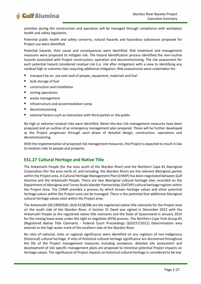
Skardon River Bauxite Project Executive Summary
Page 1-27
activities during the construction and operation will be managed through compliance with workplace health and safety legislation.
Potential public health and safety concerns, natural hazards and hazardous substances proposed for Project use were identified.
Potential hazards, their cause and consequences were identified. Risk treatment and management measures were proposed to mitigate risk. The hazard identification process identified the non-routine hazards associated with Project construction, operation and decommissioning. The risk assessment for each potential hazard considered residual risk (i.e. risk after mitigation) with a view to identifying any residual high or extreme risks requiring additional mitigation. Risk assessments were undertaken for:
transport by air, sea and road of people, equipment, materials and fuel
bulk storage of fuel
construction and installation
mining operations
waste management
infrastructure and accommodation camp
decommissioning
external factors such as interaction with third parties or the public.
No high or extreme residual risks were identified. Never-the-less risk management measures have been proposed and an outline of an emergency management plan prepared. These will be further developed as the Project progresses through each phase of detailed design, construction, operations and decommissioning.
With the implementation of proposed risk management measures, the Project is expected to result in low to medium risks to people and property.
ES1.27 Cultural Heritage and Native Title
The Ankamuthi People (for the area south of the Skardon River) and the Northern Cape #1 Aboriginal Corporation (for the area north of, and including, the Skardon River) are the relevant Aboriginal parties within the Project area. A Cultural Heritage Management Plan (CHMP) has been negotiated between Gulf Alumina and the Ankamuthi People. There are two Aboriginal cultural heritage sites recorded on the Department of Aboriginal and Torres Strait Islander Partnerships (DATSIP) cultural heritage register within the Project Area. The CHMP provides a process by which known heritage values and other potential heritage values within the Project area can be managed. There is the potential that additional Aboriginal cultural heritage values exist within the Project area.
The Ankamuthi (QC1999/026; QUD 6158/98) are the registered native title claimants for the Project area on the south side of the Skardon River. A Section 31 Deed was signed in December 2013 with the Ankamuthi People as the registered native title claimants and the State of Queensland in January 2014 for the mining lease areas under the right to negotiate (RTN) process. The Northern Cape York Group #1 (Registered Native Title Claimants - Federal Court Proceedings QUD157/2011) Determination area extends to the high water mark of the southern side of the Skardon River.
No sites of national, state or regional significance were identified on any registers of non-Indigenous (historical) cultural heritage. If sites of historical cultural heritage significance are discovered throughout the life of the Project management measures including avoidance, detailed site assessment and development of site specific management plans are proposed to minimise potential Project impacts on heritage values. The significance of Project impacts on historical cultural heritage is considered to be low.
Skardon River Bauxite Project Executive Summary
Page 1-28
ES1.28 Social and Economic Impacts
The socio-economic impact assessment identifies the nature and extent to which Project impacts the social and economic environment. The socio-economic baseline was assessed for the local and regional areas, it characterised social values (through desktop assessment and direct consultation) and identified potential Project effects against those values.
Project related impacts were identified using an impact significance assessment methodology by considering the sensitivity of a particular social value and the magnitude of a predicted impact.
Mitigation and management measures were derived through direct consultation with the community, examination of Project’s potential effects and negotiations between the proponent and governmental and non-governmental stakeholders.
The most significant adverse impacts identified as arising from the Project relate to population growth placing demand on social infrastructure, such as housing, commercial property, education, healthcare and ports.
However, it has been assessed that following the application of appropriate mitigation and management measures, the Project will have a generally positive social and economic effect on the local and regional area through increased economic activity, employment and incomes and direct benefits for industries other than mining (e.g. construction, port activities and retail).
The most significant positive social and economic impacts within the study area includes the following:
The Project has the potential for medium to long term beneficial impacts to local and regional
communities through employment of construction (100 people) and operational phase (160 people)
workers and the associated economic benefits in the supply of goods and services to the Project.
It is anticipated that approximately 40% of the workforce will be sourced from local populations
residing in or near Mapoon, Northern Peninsula Area (NPA), Napranum, Weipa and Aurukun.
Workforce members would FIFO to site but those sourced from local communities are anticipated to
already be residing in the local area and would be unlikely to create additional pressure on housing
stocks.
The proponent will actively encourage local and regional residents to take up employment
opportunities at the Project through the procurement of contractors who enhance employment
opportunities for all groups including underrepresented groups. The procurement of contractors will
include an Indigenous Training Program (ITP) and ‘Preferential Contracting Policy’ as described in the
Section 31 Deed and an Ancillary Agreement for ‘Local Aboriginal People’ (defined in the Ancillary
Agreement as Aboriginal people who either have Traditional Rights, or are normally resident in ‘North
Western Cape York’).
For tenders relating to a ‘Contracting Opportunity’, the proponent has agreed to give first preference
to tenders from a ‘Local Aboriginal Business’ and thereafter to the tenderer who best involves
Traditional Owners and Local Aboriginal Business in its tender. These recruitment and business
development measures will be delivered through a Local Aboriginal Business Opportunity Plan
(Business Opportunity Plan).
The Project will generate revenue for the State and Federal government in the form of taxes and
royalties. The Project is predicted to result in approximately $325 million of royalty payments to State
government over the life of the Project, a portion of which will be returned to Traditional Owners.
The contributions through proceeds from royalty payments are expected to assist in the funding of a
wide range of services to the benefit of the community. This includes the management and
maintenance of critical social and economic infrastructure such as local roads, libraries, sporting
Skardon River Bauxite Project Executive Summary
Page 1-29
grounds and swimming pools, parks and playgrounds, community halls, and street lighting, as well as
providing services such as waste collection, information and economic development.
Based on estimated annual wages of the construction and operational workforce the Queensland
State Government could expect to receive approximately $600,000 per annum in payroll tax per
annum over the Project life (based only on the mine’s direct employment effects). Additional revenue
is expected to be generated through Port dues and other State duties and taxes. It is estimated that
Project will contribute $434 million in Federal taxes over the life of the Project.
The Project is expected to have a beneficial impact on Indigenous people residing in the socio-economic study area through the provision of increased business opportunities, employment, education and training opportunities.
Overall the Project is expected to meet the environmental objectives and performance outcomes for social and economic values.
ES1.29 Matters of National Environmental Significance
An assessment of the significance of impacts, in accordance with the Commonwealths Significant Impact Guidelines, was undertaken for Commonwealth marine areas and all EPBC Act listed species and ecosystems considered to have a moderate / possible, likely / high or confirmed occurrence in the Project activity areas. These assessments concluded that, following mitigation measures, there would be no significant impacts to any Commonwealth marine areas or MNES listed species or ecosystems. Offsets are proposed for significant residual impacts to MSES for clearing of 1 ha MSES wetland for the crossing of Namaleta Creek and Tributary 1, and for clearing of 0.03 ha of mangroves at the Port.
ES1.30 Cumulative Impacts
Cumulative impacts are considered for all known or reasonably foreseeable projects with the potential for spatial and temporal impacts in combination with the Skardon River Bauxite Project. The projects in the Cape York region which potentially meet these criteria are:
Metro Mining Ltd’s (formerly Cape Alumina Ltd’s) Bauxite Hills project
Rio Tinto’s existing bauxite mining operation near Weipa
Rio Tinto’s proposed South of Embley Project
Rio Tinto’s existing and proposed projects are not considered to have a cumulative impact on environmental values with the Skardon River Bauxite Project as the projects are approximately 90 km apart, do not share the same catchments or hydrology and do not operate in the same near shore waters. Rio Tinto’s existing and proposed projects have been considered for cumulative social and economic impacts in the Cape York region.
The Bauxite Hills project is considered to have a cumulative environmental impact with the Skardon River Bauxite Project. Based on publically available information, the Bauxite Hills project would be for an integrated bauxite mine adjacent (east and west) to the Project and port located to the immediate south of the Port of Skardon River. The EPBC Act Referral information for the Bauxite Hills project describes a 2 Mtpa bauxite mine with over 21 year mine life (subsequently revised to 5 Mtpa over 12 years) and a 61.5 Mt indicated and inferred resource. The Bauxite Hills project includes a new barge loading facility on the Skardon River, barging of bauxite to an offshore transhipment area, workers camp and haul road transport corridor. A conceptual mine plan for the Bauxite Hills project shows mining to the east and west of the Skardon River Bauxite Project.
Skardon River Bauxite Project Executive Summary
Page 1-30
Cumulative environmental impacts with Bauxite Hills project have been assessed for land values, land use, water quality (surface water and groundwater), hydrology (surface water and groundwater), flooding, terrestrial ecology, aquatic ecology, coastal processes, marine ecology, air quality, noise and vibration, marine transport, hazards and safety, social and economic impacts and MNES.
Following implementation of proposed mitigation, residual environmental risks from the Skardon River Bauxite Project are low to medium. It is assumed that Metro Mining will implement similar mitigation measures to reduce the risk of impacts to environmental values, thereby reducing potential cumulative impacts.
There are likely to be moderate cumulative social and economic impacts from all projects in the region, with Rio Tinto having a greater contribution to these cumulative impacts in and around Weipa such as an increase in demand on health services and emergency services. The cumulative economic benefits of all proposed projects to the region and local areas are expected to be of high beneficial significance as a result of wages and additional demand for goods and services.
Gulf Alumina will seek to cooperate and consult with Metro Mining on all aspects of potential cumulative environmental and social impacts, including information sharing of baseline environmental data and identification of measures to mitigate impacts.
ES1.31 Conclusion
This EIS provides a thorough assessment of environmental and social values that may be impacted by the Project, potential impacts to those values and measures to mitigate impacts, in accordance with the requirements of the EP Act and EPBC Act.
Residual risk assessments (i.e. after consideration of proposed mitigation measures) for impacts to environmental and social values demonstrate that the Project will have a low to medium level of risk for all environmental and social values. Proposed mitigation measures are expected to result in the achievement of environmental objectives and performance outcomes specified in the EP Regulation.
The Project is expected to bring significant economic and social benefits to the region, which when combined with the generally low to medium risk of impacts to environmental and social values, will result in a Project with net benefits to the State, region and local community.