Embed Size (px)
Citation preview

CHAPTER 2 – PROJECT APPROVALS
GULF ALUMINA LTD – SKARDON RIVER BAUXITE PROJECT

Skardon River Bauxite Project Chapter 2 – Project Approvals
Page 2-i
TABLE OF CONTENTS
2.1 Introduction .......................................................................................................2-1 2.2 Existing Approvals ..............................................................................................2-1 2.3 Activities Authorised on the Mining Lease ...........................................................2-1 2.4 Environmental Authority Amendment Application ..............................................2-1 2.5 Terms of Reference for the EIS ............................................................................2-1 2.6 Commonwealth Approvals .................................................................................2-2 2.7 EIS Process and Public Submissions .....................................................................2-2 2.8 Purpose of the EIS ..............................................................................................2-3 2.9 Environmental Authority Process ........................................................................2-4 2.10 Environmentally Relevant Activities ....................................................................2-4 2.11 Resource Activity – Aggregate Environmental Score ............................................2-5 2.12 Notifiable Activities ............................................................................................2-5 2.13 Approvals for Activities in the Marine Environment ............................................2-5 2.13.1 Maritime Zones .......................................................................................................... 2-6 2.13.2 Australian Waters ....................................................................................................... 2-7 2.13.3 Waters within the Limits of a State (Internal Waters) ............................................... 2-7 2.13.4 Tidal Waters ............................................................................................................... 2-7 2.13.5 Port of Skardon River ................................................................................................. 2-8 2.13.6 Offshore Transhipment Area ...................................................................................... 2-8 2.13.7 Environment Protection (Sea Dumping) Act 1981 (Cth) .......................................... 2-12 2.13.8 Coastal Protection and Management Act 1995 ....................................................... 2-12 2.13.9 Tidal Works ............................................................................................................... 2-12 2.13.10 Owner’s Consent ...................................................................................................... 2-12 2.13.11 Prescribed Tidal Works ............................................................................................. 2-13 2.13.12 Development Assessable under a Planning Scheme ................................................ 2-13 2.13.13 Coastal Management District and Coastal Hazard Area .......................................... 2-13 2.13.14 Disposal of Dredge Spoil or Other Solid Waste Material in Tidal Water .................. 2-13 2.13.15 Environmentally Relevant Activity 16 – Extractive and Screening Activities ........... 2-14 2.13.16 Fisheries Act 1994 .................................................................................................... 2-14 2.13.16.1 Marine Plants ........................................................................................................... 2-14 2.13.16.2 Declared Fish Habitat Area ....................................................................................... 2-14 2.13.16.3 Waterway Barrier Works .......................................................................................... 2-14 2.13.17 Maritime Operations, Pollution and Safety ............................................................. 2-15 2.14 Approvals Related to Native Title and Cultural Heritage .................................... 2-15 2.14.1 Aboriginal and Torres Strait Islander Heritage Protection Act 1984 ........................ 2-15 2.14.2 Aboriginal Cultural Heritage Act 2003 ...................................................................... 2-15 2.14.3 Native Title Act 1993 ................................................................................................ 2-16 2.15 Other Approvals ............................................................................................... 2-16 2.15.1 Sustainable Planning Act 2009 ................................................................................. 2-16 2.15.2 Air Transport ............................................................................................................ 2-16 2.15.3 Building Act 1975 ..................................................................................................... 2-17 2.15.4 Land Protection (Pests and Stock Route Management) Act 2002 ........................... 2-17 2.15.5 National Greenhouse and Energy Report Act 2007 ................................................. 2-17 2.15.6 Nature Conservation Act 1992 ................................................................................. 2-17 2.15.7 Queensland Heritage Act 1992 ................................................................................ 2-18 2.15.8 Regional Planning Interests Act 2014 and Cape York Regional Plan ........................ 2-19 2.15.9 Transport Infrastructure Act 1994 ........................................................................... 2-19 2.15.10 Transport Operations (Road Use Management) Act 1995 ....................................... 2-19
Skardon River Bauxite Project Chapter 2 – Project Approvals
Page 2-ii
2.15.11 Vegetation Management Act 1999 .......................................................................... 2-20 2.15.12 Water Act 2000 ........................................................................................................ 2-20 2.15.13 Water Supply (Safety and Reliability) Act 2008 ....................................................... 2-21
Figures
Figure 2-1 Relationship of Maritime Features, Limits and Zones ................................................ 2-6 Figure 2-2 Maritime Zones Schematic ......................................................................................... 2-7 Figure 2-3 Maritime Zones and Boundaries in Vicinity of Skardon River .................................... 2-9 Figure 2-4 Maritime Boundaries and the Offshore Transhipment Area ................................... 2-10 Figure 2-5 Tidal Waters, Coastal Management District & Erosion Prone Area – Skardon
River ......................................................................................................................... 2-11

Skardon River Bauxite Project Chapter 2 – Project Approvals
Page 2-1
2. PROJECT APPROVALS
2.1 Introduction
This chapter describes the approvals required for the Project, including the environmental impact statement (EIS) and environmental authority (EA) process under the Environmental Protection Act 1994 (EP Act), approval for a controlled action under the Commonwealth’s Environment Protection and Biodiversity Conservation Act 1999 (EPBC Act), and other approvals under the State and Commonwealth legislation.
2.2 Existing Approvals
The existing mining leases are subject to an existing EA, number MIN104486212. This EA relates to mining of kaolin on the mining leases, which has ceased. The existing EA conditions relate to the ongoing rehabilitation, decommissioning and management of the former kaolin mine.
2.3 Activities Authorised on the Mining Lease
The relevant mining tenures for the Project are granted mining lease (ML) 6025, ML 40069 and ML 40082. On 9 April 2014, the Mining Registrar under the Mineral Resources Act 1989 (MR Act) approved the addition of bauxite mining on the three MLs.
In addition, one of the stated purposes of the ML 40082 and ML 40069 is “loading facilities”. These MLs overlap the sections of the Skardon River where port development (Port of Skardon River) is proposed for loading of bauxite onto barges, and supply of equipment and materials. Gulf has confirmed with Department of Natural Resources and Mines (DNRM) that “loading facilities” includes port development. Therefore port development activities will be approved under the Project’s environmental authority.
2.4 Environmental Authority Amendment Application
Gulf applied for an EA amendment for bauxite mining within the existing mining leases in March 2014 as the current EA only allows for mining kaolin and operating an associated pilot plant. Environment and Heritage Protection (EHP) decided that the proposed amendment was a major amendment under sections 228 and 229 of the EP Act. On 19 May 2014, EHP notified Gulf that the amendment application required assessment by EIS.
In May 2015, Gulf proposed a change to the EA amendment application under Sections 236 – 238 of the EP Act to include additional bauxite resources. In May 2015, EHP determined that the proposed changes would be assessed as part of this EIS.
2.5 Terms of Reference for the EIS
Gulf submitted an Initial Advice Statement (IAS) and the draft Terms of Reference (ToR) for the Project’s EIS in September 2014. The draft TOR was advertised for the period beginning 13 October 2014 until 24 November 2014. Comments on the draft TOR were received from the following government agencies, regional bodies and the community during the public submission period:
1. Department of Environment and Heritage Protection (EHP) 2. North Queensland Bulk Ports Corporation

Skardon River Bauxite Project Chapter 2 – Project Approvals
Page 2-2
3. Queensland Treasury and Trade 4. Department of Energy and Water Supply (DEWS) 5. Department of Natural Resources and Mines (DNRM) 6. Department of National Parks, Recreation, Sport and Racing (DNPRSR) 7. Department of Aboriginal and Torres Strait and Multicultural Affairs (DATSMA) 8. Public Safety Business Agency (PSBA), including Queensland Fire and Emergency Services (QFES) 9. Department of Tourism, Major Events, Small Business and the Commonwealth Games 10. Department of Agriculture, Fisheries and Forestry (DAFF) 11. Department of Transport and Main Roads (DTMR) 12. Queensland Ambulance Service (QAS) 13. Department of the Environment (Australian Government) (DoE) 14. Department of Education, Training and Employment (DETE) 15. Department of Housing and Public Works (DHPW) 16. Queensland Health 17. Metro Mining Ltd. (formerly Cape Alumina Ltd.) 18. Department of State Development, Infrastructure and Planning (DSDIP)
Following Gulf’s responses to the comments received on the draft ToR (under Section 45 of the EP Act), the final ToR was approved on 15 January 2015.
2.6 Commonwealth Approvals
The proposed Project was referred on 14 August 2014 to the Commonwealth Department of the Environment (DoE) (EPBC 2014/7305). On 11 September 2014, the Minister for the Environment determined the proposed Project to be a controlled action under the EPBC Act. The controlling provisions are sections 18 and 18A (listed threatened species and communities), 20 and 20A (listed migratory species) and 23 and 24A (Commonwealth marine areas).
The Project will be assessed under the bilateral agreement between the Commonwealth and the State of Queensland using the EIS prepared under the EP Act.
On 18 February 2015 DoE approved an application to vary the original Referral to include resource extraction within ML 6025 south of Namaleta Creek.
On 22 April 2015, DoE approved an application to vary the original Referral to increase the depth of bed levelling and the volume of material to be transferred by bed levelling.
It is expected that approval for the Project from the DoE will be subject to a number of conditions of approval related to matters of national environmental significance.
2.7 EIS Process and Public Submissions
Following submission of the EIS, EHP will decide if the EIS can proceed to public notice. Within 20 days of receiving a notice to proceed from EHP, Gulf will:
give written notice of the Project to each affected and interested person for the Project
publish a notice of the EIS in one or more newspapers
make a copy of the submitted EIS available on Gulf’s website.
The EIS notice will state:
a description of the Project and the operational land
where the submitted EIS may be inspected
where copies of, or extracts from, the submitted EIS may be obtained
Skardon River Bauxite Project Chapter 2 – Project Approvals
Page 2-3
that anyone may make a submission to the chief executive of EHP about the submitted EIS
the period (the submission period) during which submissions may be made (minimum 30 business
days)
how to make a properly made submission
another matter prescribed under a regulation.
A submission is properly made if it:
is written; and
is signed by or for each person (signatory) who made the submission; and
states the name and address of each signatory; and
is made to the chief executive of EHP; and
is received on or before the last day of the submission period.
Gulf will provide a response to submissions received on the EIS and amend the EIS as required. EHP will then decide if the response to submissions is adequate and whether the EIS can proceed. EHP then prepare an EIS Assessment Report, which once finalised, completes the EIS process.
This EIS addresses the requirements of the EP Act administered by EHP and the EPBC Act administered by DoE. The key information requirements of the EP Act that are addressed in this EIS are:
the requirements of section 40 of the EP Act, which specifies the purpose of an EIS and of the EIS
process
sections 125 and 126 which set out the general information requirements for applications for an EA
schedule 1 of the Environmental Protection Regulation 2008 (EP Regulation)—matters to be
addressed by assessment under the bilateral agreement between the Commonwealth and the State
of Queensland
the environmental objectives and performance outcomes specified in schedule 5, part 3, table 1 of
the EP Regulation.
2.8 Purpose of the EIS
The purposes of an EIS, as addressed in this EIS are as follows—
to assess the potential adverse and beneficial environmental, economic and social impacts of the
Project; and management, monitoring, planning and other measures proposed to minimise any
adverse environmental impacts of the Project
to consider feasible alternative ways to carry out the Project
to give enough information about the above matters to the Commonwealth and State authorities
and the public
to prepare or propose an environmental management plan for the Project to inform the
environmental authority application
to give information to other Commonwealth and State authorities to help them make informed
decisions
to meet any assessment requirements under the EPBC Act as the Project is a controlled action under
a bilateral agreement;
to allow the State to meet its obligations under a bilateral agreement.

Skardon River Bauxite Project Chapter 2 – Project Approvals
Page 2-4
2.9 Environmental Authority Process
The EA process commenced on lodgement of the environmental authority amendment application. EHP will commence the decision stage for the grant of the EA once the EIS Assessment Report has been finalised.
As the mining leases are granted, the EA will take effect on the day the EA is issued.
Chapter 4 of the EP Regulation prescribes the regulatory requirements with which the administering authority is required to comply for making environmental management decisions — including the issuing of an EA. To facilitate this, EHP has developed a set of model conditions for resource projects, which form the basis for proposed EA conditions and general environmental protection commitments in the EIS. The EIS describes impact mitigation measures in the context of these model conditions.
Gulf Alumina has proposed draft environmental authority conditions, which are provided in Appendix 14, based on the commitments and management measures proposed in EIS and the environmental management plan (EM Plan) (Appendix 13).
2.10 Environmentally Relevant Activities
Environmentally relevant activities (ERAs) are prescribed activities for which approval is required. A full list of all of the prescribed ERAs can be found in schedule 2 of the EP Regulation. The following ERAs will potentially be triggered by the Project:
ERA 8 Chemical storage - storing 500 m3 or more of chemicals of class C1 or C2 combustible liquids
under AS 1940 or dangerous goods class 3 with an aggregate environmental score (AES) of 85.
ERA 15 Fuel burning – using fuel burning equipment that is capable of burning at least 500kg of fuel
in an hour.
ERA 33 Crushing, milling, grinding or screening more than 5000 t of material in a year with an AES of
0.
ERA 56 Regulated waste storage – operating a facility for receiving and storing regulated waste for
more than 24 hours with AES of 211.
ERA 58 Regulated waste treatment – operating a facility for receiving and treating regulated waste
or contaminated soil to render the waste or soil non-hazardous or less hazardous, with an AES of 90.
ERA 60 Waste disposal – operating a facility for disposing of less than 50,000t per year of limited
regulated waste and general waste AES of 50.
ERA 63 Sewage treatment – operating sewage treatment works at a site that have a total daily peak
design capacity of at least 21 equivalent persons (EP); or operating a sewage pumping station with a
total design capacity of more than 40 KL in an hour with AES of 27 (100 to 1,500 equivalent persons
with treated effluent discharged through an irrigation scheme).
The applicability of ERA 16 – Extractive and screening activities to the Project’s bed levelling activities is discussed in Section 2.13.15.
ERA 31 - Mineral processing - is not triggered as the Project does not involve beneficiation of the bauxite ore. The bauxite is mined and then directly shipped to market.
1 Gulf does not intend to store regulated waste, other than temporarily prior to removal to an appropriately licensed waste disposal facility. ERA 56 does not apply to storing regulated waste in transit. Hence ERA 56 may not be applicable to the Project.

Skardon River Bauxite Project Chapter 2 – Project Approvals
Page 2-5
ERA 53 Composting and soil conditioner manufacturing , from organic material or organic waste 200t or more of compost or soils conditioners per year, is not expected to be triggered as bio-remediation of biosolids from sewerage treatment is expected to be less than 200 t per annum.
ERA 57 - Regulated waste transport - is not triggered as Gulf will engage an appropriately licensed waste contractor to remove all regulated waste from the Project area.
2.11 Resource Activity – Aggregate Environmental Score
Under Schedule 2A of the EP Act, the Project is for ‘mining bauxite’ which has an AES of 97.
2.12 Notifiable Activities
Under Section 371 of the EP Act, an owner or occupier of land must notify EHP if a ‘notifiable activity’ is being carried out on the land. A list of notifiable activities is provided in Schedule 3 to the EP Act and includes activities such as storing mine wastes, mineral processing and fuel storage.
The effect of this notification is that information about the activity will be made publicly available on EHP’s Environmental Management Register.
The following notifiable activities may potentially occur within the Project area (i.e. the Project’s mining leases):
7 Chemical Storage (other than petroleum products or oil) – storing more than 10 t of chemicals that are dangerous goods.
20 Landfill—disposing of waste (excluding inert construction and demolition waste).
23 Metal treatment or coating – treating or coating metal including, for example, anodising, galvanising, pickling, electroplating, heat treatment using cyanide compounds and spray painting using more than 5 L of paint per week.
24 Mine wastes—
(a) storing hazardous mine or exploration wastes, including, for example, tailings dams, overburden or waste rock dumps containing hazardous contaminants; or
(b) exploring for, or mining or processing, minerals in a way that exposes faces, or releases groundwater, containing hazardous contaminants.
27 Pest control—commercially operating premises, other than premises operated for farming crops or stock, where—
(a) more than 200 L of pesticide are stored; and
(b) filling or washing of tanks used in pest control operations occurs.
29 Petroleum product or oil storage – storing petroleum or oil products that are class C1 or C2 combustible liquids in above ground tanks with more than 25,000L capacity.
37 Waste storage, treatment or disposal – storing or disposing of regulated waste.
2.13 Approvals for Activities in the Marine Environment
This section describes approvals that are potentially required for Project activities in the marine environment: Port development at the Port of Skardon River, bed levelling in the mouth of the Skardon River, barging of bauxite, supply via ship of materials and equipment, and offshore transhipment of bauxite to bulk carrier vessels. These activities are described in Chapter 5.

Skardon River Bauxite Project Chapter 2 – Project Approvals
Page 2-6
As noted in Section 2.3, Port development activities are an authorised purpose of the mining lease and will be approved under the Project’s EA.
2.13.1 Maritime Zones
Maritime zones are defined below and illustrated in Figure 2-1 and Figure 2-2. In relation activities in the marine environment the definitions of relevance are:
Territorial Sea Baseline
Coastal Waters
Territorial Sea
The term Territorial Sea Baseline refers to the line from which the seaward limits of Australia's Maritime Zones are measured. These include the breadth of the territorial sea; the seaward limits of the contiguous zone, the exclusive economic zone and, in some cases, the continental shelf. The normal baseline corresponds with the low water line along the coast, including the coasts of islands. Normal baseline corresponds to the level of Lowest Astronomical Tide (LAT). Bay or river closing lines are straight lines drawn between the respective low-water marks of the natural entrance points of bays or rivers.
Coastal Waters is a belt of water between the limits of the Australian States and the Northern Territory and a line 3 nautical miles (M) seaward of the territorial sea baseline. Jurisdiction over the water column and the subjacent seabed is vested in the adjacent State or Territory as if the area formed part of that State or Territory.
The Territorial Sea is a belt of water not exceeding 12 M in width measured from the territorial sea baseline. Australia's sovereignty extends to the territorial sea, its seabed and subsoil, and to the air space above it.
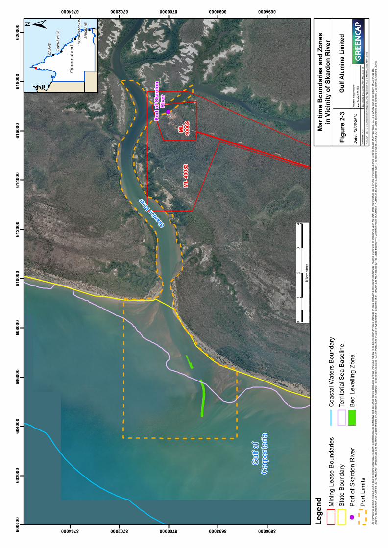
The maritime zones in vicinity of Skardon River are shown in Figure 2-3 and Figure 2-4.
Figure 2-1 Relationship of Maritime Features, Limits and Zones

Skardon River Bauxite Project Chapter 2 – Project Approvals
Page 2-7
Figure 2-2 Maritime Zones Schematic
2.13.2 Australian Waters
Australian waters means the territorial sea of Australia and any sea that is on the landward side of the territorial sea of Australia, other than any part of the sea that is within the limits of a State (see Section 2.13.3) or of the Northern Territory.
The territorial sea in the vicinity of the Skardon River is shown in Figure 2-3 and Figure 2-4.
2.13.3 Waters within the Limits of a State (Internal Waters)
Waters within the limits of a State (Internal Waters) are those waters that lie within the constitutional limits of the State as determined by Letters Patent issued to the Governors of each of the States at Federation. They can include features such as bays, gulfs, estuaries, rivers, creeks, inlets, ports or harbours. Generally, the limits of the States are low water along the coastline together with bay closing lines (usually of no more than 6 nm in length) and also river closing lines. In some areas of the coastline, locating the limits of the State may be difficult. This can occur particularly where islands lie very close to the coastline and in relation to certain bays. In such cases there are detailed legal principles that must be applied to determine the exact location of the State limits.
The approximate state boundary in the vicinity of the Skardon River is shown in Figure 2-3.
2.13.4 Tidal Waters
Land under tidal water (tidal land) includes land lying below the level of mean high water at spring tide (MHWS), also referred to as the high-water mark (HWM), within the sea or the waters of any harbour, including any navigable river up to the upstream limit of influence of the spring tide on the river.
The proposed area of bed levelling will occur in an area demarcated as tidal waters on State government mapping (refer Figure 2-5).

Skardon River Bauxite Project Chapter 2 – Project Approvals
Page 2-8
2.13.5 Port of Skardon River
Far North Queensland Ports Corporation Limited, trading as Ports North, is a company Queensland Government Owned Corporation responsible for the development and management of the declared Port of Skardon River, as well as other ports in north Queensland. The port limits for the Port of Skardon River are shown in Figure 2-3. The Port of Skardon River is not defined ‘strategic port land’.
2.13.6 Offshore Transhipment Area
The offshore transhipment area is beyond the defined Coastal Waters administered by the State, but within the Territorial Sea area, as shown in Figure 2-4. Activities within the transhipment area will be subject to approval by the Commonwealth under the EPBC Act.
! (
Gulf o
fCa
rpenta
ria
Skardon
River
ML 40
082
ML 4006
9Port
of Sk
ardon
Rive
r
6000
0060
2000
6040
0060
6000
6080
0061
0000
6120
0061
4000
6160
0061
8000
6200
008696000
8696000
8698000
8698000
8700000
8700000
8702000
8702000
8704000
8704000
!
!
!
!
ROCK
HAMP
TON
BRIS
BANE
CAIR
NS
TOW
NSVIL
LE
Quee
nslan
d
No w
arran
ty is
given
in re
lation
to th
e data
(inclu
ding a
ccura
cy, re
liabil
ity, c
omple
tenes
s or s
uitab
ility)
and a
ccep
t no l
iabilit
y (inc
luding
with
out li
mitat
ion, li
abilit
y in n
eglig
ence
) for a
ny lo
ss, d
amag
e or c
osts
(inclu
ding c
onse
quen
tial d
amag
e) rel
ating
to an
y use
of or
relia
nce u
pon t
he da
ta. D
ata m
ust n
ot be
used
for d
irect
marke
ting o
r be u
sed i
n bre
ach o
f priv
acy l
aws.
ELP
is a w
holly
owne
d sub
sidiar
y of G
reenc
ap Lt
d.Im
agery
sourc
ed fro
m Gu
lf Alum
ina (2
014).
Mari
time T
errito
rial S
ea an
d Mari
time C
oasta
l Wate
rs ©
Comm
onwe
alth o
f Aus
tralia
- Geo
scien
ce Au
strali
a (20
15). P
ort Li
mits
© St
ate of
Que
ensla
nd - D
epart
ment
of Tra
nspo
rt and
Main
Roa
ds (2
015).
Stat
e Bou
ndary
© C
ommo
nwea
lth of
Aus
tralia
- Aus
tralia
n Bure
au of
Stat
istics
(201
1). Te
nure
s © G
eos M
ining
(201
5). S
tate B
ound
aries
and T
owns
© G
eosc
ience
Aus
tralia
(200
6).
±
Figur
e 2-3
Gulf A
lumina
Limi
ted
Lege
nd Minin
g Lea
se B
ound
aries
State
Boun
dary
! (Po
rt of S
kardo
n Rive
rPo
rt Lim
its
Coas
tal W
aters
Boun
dary
Territ
orial
Sea B
aseli
neBe
d Lev
elling
Zone
01
23
4Kil
omete
rs
G:\C
LIENT
S\E-TO
-M\G
ulf Al
umina
\GIS
\Map
s\EIS\
Ch02
_App
rovals
\FIG_
2_3_
Mariti
meZo
nes_
1508
12.m
xd
Revis
ion: R
1
Date:
12/08
/2015
Auth
or: m
alcolm
.nunn
1:75,0
00Ma
p Sca
le:
Coor
dinate
Sys
tem: G
DA 19
94 M
GA Zo
ne 54
Marit
ime B
ound
aries
and Z
ones
in Vic
inity
of Sk
ardon
Rive
r

! (
Gulf o
fCa
rpenta
ria
ML 60
25
Skardon
River
ML 40
082
ML 4006
9Port
of Sk
ardo
nRi
ver
5700
0057
5000
5800
0058
5000
5900
0059
5000
6000
0060
5000
6100
0061
5000
6200
008685000
8685000
8690000
8690000
8695000
8695000
8700000
8700000
8705000
8705000
8710000
8710000
8715000
8715000
!
!
!
!
ROCK
HAMP
TON
BRIS
BANE
CAIR
NS
TOW
NSVIL
LE
Quee
nslan
d
No w
arran
ty is
given
in re
lation
to th
e data
(inclu
ding a
ccura
cy, re
liabil
ity, c
omple
tenes
s or s
uitab
ility)
and a
ccep
t no l
iabilit
y (inc
luding
with
out li
mitat
ion, li
abilit
y in n
eglig
ence
) for a
ny lo
ss, d
amag
e or c
osts
(inclu
ding c
onse
quen
tial d
amag
e) rel
ating
to an
y use
of or
relia
nce u
pon t
he da
ta. D
ata m
ust n
ot be
used
for d
irect
marke
ting o
r be u
sed i
n bre
ach o
f priv
acy l
aws.
ELP
is a w
holly
owne
d sub
sidiar
y of G
reenc
ap Lt
d.Im
agery
sourc
ed fro
m Gu
lf Alum
ina (2
014).
Mari
time T
errito
rial S
ea, M
aritim
e Coa
stal W
aters,
Mari
ne C
ontig
uous
Zone
© C
ommo
nwea
lth of
Aus
tralia
- Geo
scien
ce A
ustra
lia (2
015).
Port
Limi
ts ©
State
of Q
ueen
sland
- Dep
artme
nt of
Trans
port a
nd M
ain R
oads
(201
5). S
tate B
ound
ary ©
Com
monw
ealth
of Au
strali
a - Au
strali
an B
ureau
of S
tatist
ics (2
011).
Tenu
res ©
Geo
s Mini
ng (2
015)
. Stat
e Bou
ndari
es an
d Tow
ns ©
Geo
scien
ce Au
strali
a (20
06).
±
Figur
e 2-4
Gulf A
lumina
Limi
ted
Lege
nd Minin
g Lea
se B
ound
aries
State
Boun
dary
! (Po
rt of S
kardo
n Rive
rPo
rt Lim
its
Territ
orial
Sea B
aseli
neCo
astal
Wate
rs Bo
unda
ryTe
rritori
al Se
a Bou
ndary
Conti
guou
s Zon
e
Offsh
ore Tr
ansh
ipmen
t Area
Bed L
evell
ing Zo
ne
02.5
57.5
10Kil
omete
rs
G:\C
LIENT
S\E-TO
-M\G
ulf Al
umina
\GIS
\Map
s\EIS\
Ch02
_App
rovals
\FIG_
2_4_
Mariti
meZo
nes_
Overv
iew_1
5081
2.mxd
Revis
ion: R
1
Date:
12/08
/2015
Auth
or: m
alcolm
.nunn
1:200
,000
Map S
cale:
Co
ordin
ate S
ystem
: GDA
1994
MGA
Zone
54
Mari
time B
ound
aries
and t
heOf
fshor
e Tran
shipm
ent A
rea

! (
Gulf o
fCa
rpenta
ria
Skardon
River
ML 40
082
ML 4006
9
Port
of Sk
ardon
Rive
r
6040
0060
6000
6080
0061
0000
6120
0061
4000
6160
0061
8000
8696000
8696000
8698000
8698000
8700000
8700000
8702000
8702000
8704000
8704000
!
!
!
!
ROCK
HAMP
TON
BRIS
BANE
CAIR
NS
TOW
NSVIL
LE
Quee
nslan
d
No w
arran
ty is
given
in re
lation
to th
e data
(inclu
ding a
ccura
cy, re
liabil
ity, c
omple
tenes
s or s
uitab
ility)
and a
ccep
t no l
iabilit
y (inc
luding
with
out li
mitat
ion, li
abilit
y in n
eglig
ence
) for a
ny lo
ss, d
amag
e or c
osts
(inclu
ding c
onse
quen
tial d
amag
e) rel
ating
to an
y use
of or
relia
nce u
pon t
he da
ta. D
ata m
ust n
ot be
used
for d
irect
marke
ting o
r be u
sed i
n brea
ch of
priva
cy la
ws. E
LP is
a wh
olly o
wned
subs
idiary
of G
reenc
ap Lt
d.Im
agery
sourc
ed fro
m Gu
lf Alum
ina (2
014).
Mari
time T
errito
rial S
ea an
d Mari
time C
oasta
l Wate
rs ©
Comm
onwe
alth o
f Aus
tralia
- Geo
scien
ce A
ustra
lia (2
015).
Port
Limi
ts ©
State
of Q
ueen
sland
- Dep
artme
nt of
Trans
port a
nd M
ain R
oads
(201
5). S
tate B
ound
ary ©
Com
monw
ealth
of A
ustra
lia - A
ustra
lian B
ureau
of S
tatist
ics (2
011).
Tenu
res ©
Geo
s Mini
ng (2
015).
Stat
e Bou
ndari
es an
d Tow
ns ©
Geo
scien
ce Au
strali
a (20
06).
Quee
nslan
d Wate
rway
s for
Water
way B
arrier
Work
s - A
reas ©
Stat
e of Q
ueen
sland
- Dep
artme
nt of
Agric
ulture
, Fish
eries
and F
orestr
y (20
13).
Eros
ion P
rone A
reas ©
Stat
e of Q
ueen
sland
- Dep
artme
nt of
Envir
onme
nt an
d Heri
tage P
rotec
tion (
2015
).
±
Figur
e 2-5
Gulf A
lumina
Limi
ted
Lege
nd Minin
g Lea
se B
ound
aries
! (Po
rt of S
kardo
n Rive
rBe
d Lev
elling
Zone
Tidal
Water
sCo
astal
Man
agem
ent C
ontro
l Dist
ricts
Eros
ion P
rone A
reas
01
23
4Kil
omete
rs
G:\C
LIENT
S\E-TO
-M\G
ulf Al
umina
\GIS
\Map
s\EIS
\Ch0
2_Ap
prova
ls\FIG
_2_5
_Coa
stalM
gmt_1
5081
2.mxd
Revis
ion: R
1
Date:
12/08
/2015
Auth
or: m
alcolm
.nunn
1:60,0
00Ma
p Sca
le:
Coor
dinat
e Sys
tem: G
DA 19
94 M
GA Zo
ne 54
Tidal
Water
s, Co
astal
Man
agem
ent D
istric
tan
d Ero
sion P
rone
Area
- Vici
nity o
f Ska
rdon
Rive
r

Skardon River Bauxite Project Chapter 2 – Project Approvals
Page 2-12
2.13.7 Environment Protection (Sea Dumping) Act 1981 (Cth)
As advised by DoE, a Sea Dumping Permit under the Environment Protection (Sea Dumping) Act 1981 is not required for bed levelling activities as bed levelling is confined to underwater works whereby material on the sea floor is to be moved from one area to another.
The Commonwealth’s National Assessment Guidelines for Dredging (NAGD) consider an activity to involve dredging if there is “loading” and “dumping” of material. The NAGD defines ‘dumping’ as deliberate disposal into the sea of wastes or other materials from vessels….” and therefore bed levelling does not fall within this definition. The NAGD describes loading and, again, bed levelling does not meet the description of loading. Therefore the NAGD do not consider bed levelling to be dredging.
2.13.8 Coastal Protection and Management Act 1995
The Coastal Protection and Management Act 1995 (Qld) (CPM Act) provides for the protection, conservation, rehabilitation and management of the coastal zone, including its resources and biological diversity. It applies to areas within the coastal zone, as defined in the Queensland Coastal Plan 2012.
2.13.9 Tidal Works
No tidal works may be carried out in, on or above land under tidal water in the State of Queensland without a development approval in the form of a development permit pursuant to the provisions of the Sustainable Planning Act 2009 (SP Act).
Under the CPM Act:
Tidal works include works in, on or above land under tidal water.
Tidal works include the construction or demolition of a basin, boat ramp, breakwater, bridge, dam,
dock, dockyard, embankment, groyne, jetty, pipeline, pontoon, powerline, seawall, slip, small craft
facility, training wall or wharf.
Tidal works does not include works that are assessable development, carried out within a coastal
management district for the disposal of dredge spoil or other solid waste material in tidal water.
Bed levelling will be undertaken within a navigation channel in the Skardon River that will be defined based on current and future bathymetrical surveys. Bathymetry surveys conducted to date, including in 2009 by Ports North and 2015 by Gulf Alumina, are reported in Chapter 17.
A tidal works permit will be required for the bed levelling activities including initial bed levelling and subsequent maintenance bed levelling within the defined navigation channel. The tidal works development authority application will be supported by the information on coastal processes and marine ecology provided in this EIS (Chapter 17 and Chapter 18).
2.13.10 Owner’s Consent
Where the Queensland Government has jurisdiction over land below high water mark (HWM), the State has two roles in the assessment of a development proposal:
Owner of the resource—providing owner’s consent to support a development application, indicating
that the proposed development is an appropriate use of the State land or resource, in accordance
with Queensland Government laws and policies.
Development assessment authority — assessing the impacts of the development to the extent of its
jurisdictional responsibilities.
Skardon River Bauxite Project Chapter 2 – Project Approvals
Page 2-13
Application for owner’s consent is evidence that the owner of land that is the subject of a development application has consented to the making of the application. The tenure of land below HWM is generally unallocated state land, overseen on behalf of the State by the DNRM.
For assessable development that is tidal works, owner’s consent is required from DNRM.
Note that the provision of owner's consent does not:
imply endorsement or approval of the related development
affect other functions exercised by the entity giving owner's consent
authorise a right to occupy and/ or use the state land under tidal water.
2.13.11 Prescribed Tidal Works
Prescribed tidal work is tidal work that is completely or partly within a local government tidal area and includes integral parts of the structure that extends onto land above high water mark.
On the open coast the local government tidal area is the seaward area within 50 metres of the high water mark. In rivers and estuaries if the same local government is on both sides of a river or estuary (waterway), the local government tidal area includes the entire width of the river or estuary up to high water mark, and from the mouth of the river or delta to as far up the river or estuary as the spring tides ordinarily flow and reflow.
The Cook Shire local government is on both sides of the Skardon River.
Bed-levelling is not within 50m of high water mark and therefore the activity is not prescribed tidal work.
2.13.12 Development Assessable under a Planning Scheme
The relevant Planning Scheme for the area is the Cook Shire Planning Scheme.
Based on a review of the Cook Shire Planning Scheme, an activity in coastal waters such as bed levelling is not covered by the Scheme and is therefore not assessable development under the Scheme.
2.13.13 Coastal Management District and Coastal Hazard Area
The proposed area of bed levelling will occur in a defined coastal management district, as shown on Figure 2-4.
The Project’s coastal areas are mapped by the State as ‘indicative coastal management district for Cook Shire to Burke Shire’, and are in a mapped ‘erosion prone area’ (refer Figure 2-5). In accordance with the CPM Act, a coastal management district includes erosion prone areas in Cook Shire.
The proposed area of bed levelling will occur in a defined coastal hazard area – erosion prone areas, as shown on Figure 2-5.
2.13.14 Disposal of Dredge Spoil or Other Solid Waste Material in Tidal Water
Operational work involving the disposal of dredge spoil or other solid waste material in tidal water, carried out completely or partly within a coastal management district, is deemed assessable development under the SP Regulation.
Per the Guideline ‘Disposing of material in tidal water’:
“Disposing of dredge spoil or other solid waste material in tidal water refers to dumping material and substances of any kind at sea (except as part of normal operations) from vessels, aircraft and platforms or other man-made structures. It also includes moving material under the mean high water mark to another location under tidal water.”

Skardon River Bauxite Project Chapter 2 – Project Approvals
Page 2-14
Bed levelling, although occurring in a coastal management district, is not considered to be disposal of dredge spoil in tidal water that involves dumping materials and substances of any kind at sea. In addition bed levelling does not result in the removal of material to another location outside of the navigation channel. As described in Section 2.13.9, bed levelling within the navigation channel will be authorised under a development authority for tidal works.
2.13.15 Environmentally Relevant Activity 16 – Extractive and Screening Activities
Proposed bed levelling activities are described in Chapter 5 and an assessment of the potential impacts of bed levelling on coastal processes and marine ecology is provided in Chapter 17 and Chapter 18 respectively.
ERA 16 – Extractive and screening activities is triggered if dredging a total of 1000 t or more of material from the bed of naturally occurring surface waters in a year.
Based on discussions with EHP, bed levelling is not considered to be dredging and hence approval for ERA 16 is not required.
2.13.16 Fisheries Act 1994
The following development related activities, as potentially relevant to the Project, may require a fisheries development approval under the SP Act:
removal, destruction or damage of marine plants
building or operational works in a declared Fish Habitat Area
waterway barrier works.
Fisheries development approval is not required for activities authorised under an environmental authority on the mining leases (including Port are development and the crossing of Namaleta Creek).
2.13.16.1 Marine Plants
Marine plants are defined in the Fisheries Act 1994 and include mangroves, seagrass, saltcouch, samphires and algae growing on or adjacent to tidal lands.
If bed levelling involves removal, destruction or damage of marine plants than a separate development approval will be required. Based on the marine ecology impact assessment (Chapter 18) it is unlikely that bed levelling will involve removal, destruction or damage of marine plants.
Port development is within the mining lease and will be conditioned through the environmental authority, and hence does not require approval for removal, destruction or damage of marine plants, if this were to occur.
Other activities in the marine environment within the State’s jurisdiction (i.e. barging of bauxite and supply vessel movements) are unlikely to involve removal, destruction or damage of marine plants.
Gulf will make application for a fisheries development approval for removal, destruction or damage of marine plants if it is likely that this will occur.
2.13.16.2 Declared Fish Habitat Area
There are no declared Fish Habitat Areas in the area of the Project’s marine activities.
2.13.16.3 Waterway Barrier Works
Waterway barrier works means a dam, weir or other barriers across a waterway if the barrier limits fish access and movement along a waterway.

Skardon River Bauxite Project Chapter 2 – Project Approvals
Page 2-15
Namaleta Creek, within the mining leases, is shown as having a ‘moderate’ risk of impact under the Queensland waterways for waterway barrier works mapping.
The Project potentially involves waterway barriers with the proposed crossing options of Namaleta Creek. However, these crossings are on the mining lease and hence will be approved and conditioned under the Project’s environmental authority.
In addition, any waterway barriers are likely to be constructed in accordance with the Code for self-assessable development: Minor waterway barrier works; Part 3: culvert crossings (DAFF, 2013).
2.13.17 Maritime Operations, Pollution and Safety
International policies, and Commonwealth and State legislation affecting maritime operations, pollution and safety are described in Chapter 22. Chapter 22 also describes the roles of Maritime Safety Queensland (MSQ) and Ports North in the ongoing management of Project related maritime operations.
2.14 Approvals Related to Native Title and Cultural Heritage
2.14.1 Aboriginal and Torres Strait Islander Heritage Protection Act 1984
The protection of Indigenous heritage is predominantly governed by Queensland’s Aboriginal Cultural Heritage Act 2003 (Section 2.14.2). The Aboriginal and Torres Strait Islander Heritage Protection Act 1984 (Cth) (ATSIHP Act) operates to provide additional levels of protection.
The purpose of the ATSIHP Act, as described under section 4 of the Act, is to provide for the ‘preservation and protection from injury or desecration of areas and objects in Australia and in Australian waters, being areas and objects that are of particular significance to Aboriginals in accordance with Aboriginal tradition’.
The ATSIHP Act enables an application to be made on behalf of an Aboriginal person or an Aboriginal group to the Minister administering the Act to declare certain areas or objects as protected on either an emergency or ongoing basis. The proponent is obligated to ensure that any area or an object declared under Part II, Divisions 1 or 2 of the ATSIHP Act is protected or preserved.
Furthermore, in accordance with section 20 of the ATSIHP Act, if the proponent discovers anything it has ‘reasonable grounds to suspect to be Aboriginal remains’, the proponent will need to report the ‘discovery to the Minister, giving particulars of the remains and of their location’.
Any requirements for the proponent to take actions under the ATSIHP Act will be determined during Project activities if and when the need arises.
2.14.2 Aboriginal Cultural Heritage Act 2003
The Aboriginal Cultural Heritage Act 2003 (Qld) (ACH Act) provides a system to protect, preserve and manage Aboriginal cultural heritage areas and objects. The object of the ACH Act is to provide recognition, protection and conservation of Aboriginal cultural heritage.
The ACH Act establishes a ‘duty of care’ that requires anyone conducting activities on land to take all reasonable and practicable measures to ensure the activity does not harm Aboriginal cultural heritage. The Duties of Care Guidelines outline reasonable and practicable measures for ensuring activities are managed to avoid or minimise harm to cultural heritage values. Penalties apply for causing unauthorised harm.
The ACH Act also:
establishes the process for identifying the relevant Aboriginal parties

Skardon River Bauxite Project Chapter 2 – Project Approvals
Page 2-16
requires a cultural heritage management plan (CHMP) be developed and approved when an EIS is
required for the approval of any project
establishes a cultural heritage database maintained by the Department of Aboriginal and Torres
Strait Islander and Multicultural Affairs (DATSIMA)
vests ownership of Aboriginal cultural heritage with Aboriginal People.
Information on the proponent’s compliance with the ACH Act is provided in Chapter 24.
2.14.3 Native Title Act 1993
The Native Title Act 1993 (Cth) (NT Act) recognises native title rights and provides the government with ways in which to validate or legitimise past acts such as the granting of leases. This legislation provides for the determination of native title claims, the treatment of future acts which may impact on native title rights and the requirement for consultation and/or notification to relevant native title claimants, where future acts are involved.
The Ankamuthi (QC1999/026; QUD 6158/98) are the registered native title claimants for the Project area on the south side of the Skardon River. Gulf has entered into a native title agreement with the Ankamuthi.
The Northern Cape York Group #1 (Registered Native Title Claimants - Federal Court Proceedings QUD157/2011) Determination area extends to the High Water Mark of the southern side of the Skardon River.
2.15 Other Approvals
This section describes approvals required for the Project, other than for the EIS Assessment Report, EA, EPBC Act controlled action decision, activities in the marine environment, native title and cultural heritage.
Other than bed levelling in the mouth of the Skardon River, there are no other Project activities with a direct impact on State land or waters outside of the Project’s mining leases.
2.15.1 Sustainable Planning Act 2009
The purpose of the SP Act is to seek to achieve ecological sustainability by:
managing the process by which development takes place, including ensuring the process is
accountable, effective and efficient and delivers sustainable outcomes
managing the effects of development on the environment, including managing the use of premises
continuing the coordination and integration of planning at the local, regional and State levels.
Part 8 of the MR Act states the SP Act does not apply to development authorised under the MR Act, other than when administering the QH Act or in relation to the Building Act.
Approvals under the SP Act are required for bed levelling, further described under Section 2.13.9.
Development associated with the Building Act and the QH Act has been addressed in Sections 2.15.3 and 2.15.7.
2.15.2 Air Transport
The legislation and policies governing the aircraft movements proposed for the Project are described in Chapter 22.
Skardon River Bauxite Project Chapter 2 – Project Approvals
Page 2-17
2.15.3 Building Act 1975
The Building Act 1975 (Qld) (Building Act) sets out what building works constitute assessable development under the Sustainable Planning Act 2009 (Qld) (SP Act) and sets out additional requirements for making a building development application. The Building Act also provides that buildings should be constructed in accordance with the building regulations set out in either the Building Code of Australia 2012 (BCA) or the Queensland Development Code 2012 (QDC).
Under section 319(3) of the MR Act, carrying out building work for development authorised under the MR Act is regarded as ‘self-assessable’ for the purposes of the SP Act. Accordingly, a development permit is not required for any building work undertaken within the boundaries of the MLs. All work associated with the assessment under this EA application will be undertaken within the boundaries of the MLs.
Section 21 of the Building Act provides that for self-assessable development (i.e. building works within the boundaries of the Project area), the proponent must still comply with the relevant provisions of the BCA or QDC when undertaking the work.
2.15.4 Land Protection (Pests and Stock Route Management) Act 2002
The Land Protection (Pest and Stock Route Management) Act 2002 (Qld) (LP Act) provides for the management of pests and the stock route network.
The LP Act outlines provisions for preventing the spread of declared pest species and identifies declared plants and animals that are targeted for control because they are pest species. Landowners must take reasonable steps to keep land free of class 1 and class 2 pests, and control class 3 pests, where the land is in or adjacent to an environmentally sensitive area.
Field assessments have been undertaken within the Project area which identified various weed and pest species. On the basis of this information, the proponent will prepare a Pest Management Plan to manage pests and weeds during both the construction and operation phases of the Project. No approval is required under the LP Act for the preparation of a Pest Management Plan.
The LP Act also provides that a person must not, without reasonable excuse, obstruct the movement of stock on a stock route (section 179), burn or remove pasture on a stock route (section 180) and place things on a stock route that may harm travelling stock (section 181). Stock routes are managed by the regional council. There are no stock routes in the Project area.
2.15.5 National Greenhouse and Energy Report Act 2007
The National Greenhouse and Energy Report Act 2007 (Cth) introduces a single national framework for the reporting of information relating to GHG emissions by requiring the submission of an annual report to the Commonwealth Department of Climate Change and Energy Efficiency recording GHG emissions, energy produced and energy consumed.
The proponent will meet its annual reporting requirement upon commencement.
2.15.6 Nature Conservation Act 1992
The Nature Conservation Act 1992 (Qld) (NC Act) provides for the conservation of Queensland’s biodiversity. In support of the purpose and the provisions of the NC Act, the Nature Conservation (Wildlife) Regulation 2006 (Qld) lists all flora and fauna species which are considered to be ‘extinct in the wild’, ‘endangered’, ‘vulnerable’, ‘near threatened’ and ‘least concern’ wildlife.
The following approvals are required from EHP under the NC Act when dealing with protected plants and animals:
Protected Animals Movement Permit (section 88 of the NC Act).

Skardon River Bauxite Project Chapter 2 – Project Approvals
Page 2-18
Protected Plants Clearing Permit (section 89 of the NC Act).
Wildlife Movement Permit (section 97 of the NC Act).
On 31 March 2014, the Nature Conservation (Protected Plants) Conservation Plan 2000 was repealed and section s89(1)(h)(iii) of the Nature Conservation Act 1992, which provided an exemption for taking protected plants for mining or petroleum activities, was removed. Before any clearing commences, a mining lease holder will be required to determine if clearing will occur in mapped ‘high risk’ areas and conduct a protected plant survey if this is the case. If protected plants are identified an application to clear will be required.
Section 332 of the Nature Conservation (Wildlife Management) Regulation 2006 (Qld) provides that a person must not, without a reasonable excuse, tamper with an animal breeding place that is being used by a protected animal to incubate or rear the animal’s offspring. This requirement will not apply where the proponent has put in place a species management program approved by EHP.
The protected plants and animals occurring within the Project area are identified in Chapter 15, Chapter 16 and Chapter 18. The proponent will secure the approvals listed above, in consultation with the EHP, prior to undertaking Project activities that could potentially impact protected flora and fauna.
The NC Act also dedicates and declares protected areas under thirteen classes for the conservation of natural and cultural heritage within national parks, conservation parks or resource reserves. The NC Act sets out management principles for each class of protected area. The Act also requires the declaration of ‘management intent’ with regards to significant cultural and/or natural resources and values for any proposed protected area. Under the NC Act, it is an offence to take, use, keep, or interfere with a cultural or natural resource in a protected area except in accordance with the interim or declared management intent, or under a permit from the Department of National Parks, Recreation, Sports and Racing (DNPRSR). The Project will not impact any protected areas.
2.15.7 Queensland Heritage Act 1992
The Queensland Heritage Act 1992 (QH Act) provides:
For the establishment of the Queensland Heritage Register – a register of places significant to the
State of Queensland.
A process for entering new places onto the Queensland Heritage Register.
For the protection for places entered in the register.
For the establishment of local heritage registers to be maintained by local government authorities.
A process for reporting discoveries of artefacts with potential historical cultural heritage
significance.
A detailed process for managing historical cultural heritage items, sites or places during project
activities that may have an impact on cultural heritage values.
The QH Act places restrictions on development within Queensland heritage places and archaeological places listed in the Queensland Heritage Register and protected areas listed under the regulation. If any aspect of the Project is likely to occur on a place listed on the Queensland Heritage Register, a development permit must be obtained. No areas of the Project have currently been identified which are listed on the Queensland Heritage Register and, accordingly, this approval is not required.
Section 89 of the QH Act requires that anyone who discovers an archaeological artefact that may be an important source of information about an aspect of Queensland’s history must report it to EHP. Under section 90 of the QH Act, it is an offence to interfere with any archaeological discovery for at least 20 business days after EHP has been notified, unless consent has been granted under the QH Act to do so.

Skardon River Bauxite Project Chapter 2 – Project Approvals
Page 2-19
The proponent will notify EHP in accordance with these requirements if any archaeological artefacts are discovered within the Project area.
2.15.8 Regional Planning Interests Act 2014 and Cape York Regional Plan
The Regional Planning Interests Act 2014 (RPI Act) requires resource activities authorised under resource acts and other regulated activities to align with the regional land use policies in the regional plans as well as other government policy. Currently, there are only two regional plans that incorporate areas of regional interest under the RPI Act (for Central Queensland and Darling Downs regions) and the Project does not fall within these regional planning areas.
The RPI Act introduces an assessment framework to manage the impact of resource activities on areas of the state identified in the bill as an “area of regional interest” — priority agricultural areas (PAAs), priority living areas (PLAs), strategic environmental areas (SEAs) and strategic cropping areas (SCAs). Under the RPI Act, a resource activity, and other identified activities, cannot occur in these areas unless a regional interests development approval (RIDA) has been given for the activity.
The RPI Act repealed the SCL Act on 13 June 2013. Land mapped as SCL anywhere in Queensland when the SCL Act was repealed became an ‘area of regional interest’. This applied regardless of whether a regional plan exists for the area. A RIDA is required to operate in areas of regional interest, including SCAs (formerly called SCL).
Based on government maps, the Project area is not within an area of regional interest.
The Cape York Regional Plan (CYRP) was made on 8 August 2014 and publicly notified by Gazette on 15 August 2014. The Project is within the defined CYRP area, which incorporates the majority of Cape York Peninsula. The CYRP has been prepared to facilitate appropriate economic development in the region and identifies strategic land-use classifications to manage competing economic and environmental state interests in the region. These classifications include SEAS, National Parks, PAAs and PLAs. The Project is not within, and does nor adjoin, any strategic land sue classification areas (areas of regional interest), as defined under the CYRP.
2.15.9 Transport Infrastructure Act 1994
The Transport Infrastructure Act 1994 (Qld) (TI Act) was established to allow for and encourage effective integrated planning and efficient transport infrastructure management. The TI Act provides for the planning and management of road, rail, and air infrastructure.
DTMR manages the Queensland State-controlled road network. Under section 50 of the TI Act, works to construct, maintain, operate or conduct ancillary works and encroachment on state roads (e.g. intersection upgrades, water and gas supply pipelines traversing under the road) will require an Ancillary Works and Encroachment Permit under the TI Act. As described in Chapter 5, the Project will not involve works to construct, maintain, operate or conduct ancillary works and encroachment on state roads.
2.15.10 Transport Operations (Road Use Management) Act 1995
The Transport Operations (Road Use Management) Act 1995 (Qld) provides for the effective and efficient management of road use in the State. The Transport Operations (Road Use Management – Mass, Dimensions and Loading) Regulation 2005 (Qld), pursuant to section 51, requires that approval be granted prior to the transport by road of over-mass or over-dimensions loads.
As described in Chapter 22 the Project will not be accessible by road and therefore approval for transport of over-dimension loads by road to site will not be required. There is a possibility that over-mass or over-dimensions loads will be transported by road to Ports in Queensland (e.g. Cairns or Weipa) before being shipped to site.

Skardon River Bauxite Project Chapter 2 – Project Approvals
Page 2-20
The Transport Operations (Road Use Management – Fatigue Management) Regulation 2008 (Qld) also requires that heavy vehicles must not be driven by persons impaired by fatigue (sections 21 and 22). This requirement will be addressed by the proponent as part of its general health and safety obligations.
2.15.11 Vegetation Management Act 1999
The Vegetation Management Act 1999 (Qld) (VM Act) regulates the conservation and management of vegetation communities and clearing of vegetation. It provides protection for regional ecosystems classified as ‘endangered’, ‘of concern’ or ‘least concern’ under the VM Act. The application for approval to clear vegetation is made under the SP Act.
Approval for vegetation clearing within the Project area will occur as a result of the grant of the EA. As no vegetation will be cleared outside of the tenement boundaries, no additional development permits will be required.
Information about the vegetation types located within the Project area, and potential offsets, is provided in Chapter 15 and Chapter 16.
2.15.12 Water Act 2000
The proposed water management strategy for the Project is described in Chapter 6. In order to supplement water supply, groundwater will be extracted from shallow aquifers within the mining leases. The Project is situated within the Great Artesian Basin (GAB), however the GAB waters are hundreds of meters deep in the Project area, and Gulf has no intention to access water from the GAB. Further information is provided in Chapter 6.
In respect of groundwater, the Water Resource (Great Artesian Basin) Plan 2006 includes groundwater from the Cape Management Area of GAB in the Project area. The Cape Management Area comprises the aquifers associated with the Helby Beds, Gilbert River Formation and Garraway Beds. As the Project will not be extracting water from these deep aquifers or impacting these deep aquifers in any way through bauxite mining, approval to take or interfere with groundwater from the GAB is not required.
The Water Reform and Other Legislation Amendment Act 2014 was passed by Queensland Parliament on 26 November 2014. The changes involved bringing mining and petroleum and gas sectors in Queensland under one consistent framework for groundwater management. A mining lease holder may apply for a water licence for taking water from an aquifer beneath the mining lease. Gulf will apply for a water licence for taking of water from shallow aquifers beneath the mining lease.
The provisions regarding the ability to apply for and grant a water licence are specified in the relevant Water Resource Plan and associated Resource Operations Plan if one exists for the area; however there is no Water Resource Plan for the waterways in Cape York that may be impacted by the Project.
It has been assumed the Namaleta Creek is a defined watercourse under the Water Act 2000. Two options for crossing Namaleta Creek have been proposed, both involving culverts. As described in Section 2.13.16, potential waterway barriers are within the mining leases and will be approved under the Project’s EA. The Project does not involve diversion of any watercourses.
As the proponent will hold an environmental authority for a resource activity (mining leases), conducting activities in a watercourse, lake or spring necessary for and associated with mining operations, may be carried by the proponent without the need for a Riverine Protection Permit under the Water Act 2000, so long as the proposed activity is carried out in accordance with the departmental Guideline - Activities in a watercourse, lake or spring associated with a resource activity or mining operations (DNRM 2012). Activities carried out within a defined watercourse, lake or spring (i.e. destroying native vegetation, excavating or placing fill), that do not comply with the Guideline - Activities in a watercourse, lake or spring associated with a resource activity or mining operations, will be authorised by a Riverine Protection Permit under the Water Act 2000.

Skardon River Bauxite Project Chapter 2 – Project Approvals
Page 2-21
2.15.13 Water Supply (Safety and Reliability) Act 2008
Under the Water Supply (Safety and Reliability) Act 2008 (Qld), any proposed dam for which a failure impact assessment is required is termed a ‘referable dam’. Pursuant to section 343, a failure impact assessment must be undertaken prior to the construction of dams that are more than 10 m in height and either have a storage capacity of more than 1,500 ML or have a storage capacity of more than 750 ML and a catchment area that is more than three times its maximum surface area at full supply level.
It is not anticipated that the Project will require the construction of any dam for which a failure impact assessment will be required. Detailed information about the dams that will be constructed as part of the Project is provided in Chapter 6.