Embed Size (px)
Citation preview
1
Excavations at Bunkle Medieval Village
By Richard Carlton with contributions by Peter Ryder, Rob Engl, Andrew Morrison,
George R. Haggarty, Anne Crone, Alex Wood and Jackaline Robertson
Thanks are due to many people for their involvement in and support for the project, not least the volunteers, who took part in excavations and surveys in all weathers. Projects like this exist because of the wealth of passion and knowledge that volunteers bring to the table, so we are most grateful to you all for your time, effort and enthusiasm:
Yvonne Buskie Deborah Campbell
Billy Campbell Frank Chambers
Annabel Crawford Liz Curtis
Hamish Darrah Alun Davies
Anna Derricourt Richard Gillanders
Ian Hawkins Sam Hope
Siena Hutton Jill and Amelie Hyslop
Fiona Keightly Robert Keightly
Sam Kinirons Louisa Love
Don Matthews Colin Macaulay
Jean McKinnon Clive McLachlan Powell Fiona McLachlan Powell
Sally Metcalf Kate Moulin and Felix
Gordon Neil Geoff Parkhouse
Daniel Proven Susan Reid, Camille and Alice
Jakki Rose Matthew Rodgers
Linda Scott Neil Simpson Rob Stirling
Richard Strathie Rachel Sutherland
Alan Wightman Val Wilson
Georgia, Harry Sonia and Tim Susie, Rory and Dillon
Our fieldwork was made possible thanks to kind permission of:
James and Joy Dobie William and Charlotte Dobie
Kate and Richard Bogie Neil Anderson Doreen Calder Scottish Water
The project was conceived by Chris Bowles, previously of Scottish Borders Council but he has since moved on to pastures new. We are grateful that Chris has continued to offer support from afar. Many thanks to Keith Elliott, who stepped in after Chris’ departure, and to Mark Douglas, also of Scottish Borders Council, who is, we hope, enjoying his retirement. Many thanks also to Stephanie Leith and Andrew Robertson of East Lothian Council.
Thanks are due to Richard Carlton, Betty Snow and the Bunkle and Preston History Group as well.
Lastly, thanks also to Stratford Halliday, Kristian Pedersen, Piers Dixon, Dave Cowley, George Geddes and Peter Corser for their professional advice to the project.
CONTENTS
Introduction and Background 3
Archaeological Investigations 8
Artefacts 16
The Palaeoenvironmental Evidence 23
Discussions and Conclusions 29
3
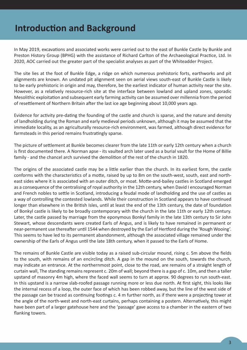
In May 2019, excavations and associated works were carried out to the east of Bunkle Castle by Bunkle and Preston History Group (BPHG) with the assistance of Richard Carlton of the Archaeological Practice, Ltd. In 2020, AOC carried out the greater part of the specialist analyses as part of the Whiteadder Project.
The site lies at the foot of Bunkle Edge, a ridge on which numerous prehistoric forts, earthworks and pit alignments are known. An undated pit alignment seen on aerial views south-east of Bunkle Castle is likely to be early prehistoric in origin and may, therefore, be the earliest indicator of human activity near the site. However, as a relatively resource-rich site at the interface between lowland and upland zones, sporadic Mesolithic exploitation and subsequent early farming activity can be assumed over millennia from the period of resettlement of Northern Britain after the last ice age beginning about 10,000 years ago.
Evidence for activity pre-dating the founding of the castle and church is sparse, and the nature and density of landholding during the Roman and early medieval periods unknown, although it may be assumed that the immediate locality, as an agriculturally resource-rich environment, was farmed, although direct evidence for farmsteads in this period remains frustratingly sparse.
The picture of settlement at Bunkle becomes clearer from the late 11th or early 12th century when a church is first documented there. A Norman apse - its vaulted arch later used as a burial vault for the Home of Billie family - and the chancel arch survived the demolition of the rest of the church in 1820.
The origins of the associated castle may be a little earlier than the church. In its earliest form, the castle conforms with the characteristics of a motte, raised by up to 8m on the south-west, south, east and north-east sides where it is associated with an outer ditch, or moat. Motte-and-bailey castles in Scotland emerged as a consequence of the centralising of royal authority in the 12th century, when David I encouraged Norman and French nobles to settle in Scotland, introducing a feudal mode of landholding and the use of castles as a way of controlling the contested lowlands. While their construction in Scotland appears to have continued longer than elsewhere in the British Isles, until at least the end of the 13th century, the date of foundation of Bonkyl castle is likely to be broadly contemporary with the church in the late 11th or early 12th century. Later, the castle passed by marriage from the eponymous Bonkyl family in the late 13th century to Sir John Stewart, whose descendants were created Earls of Angus, and is likely to have remained in permanent or near-permanent use thereafter until 1544 when destroyed by the Earl of Hertford during the ‘Rough Wooing’. This seems to have led to its permanent abandonment, although the associated village remained under the ownership of the Earls of Angus until the late 18th century, when it passed to the Earls of Home.
The remains of Bunkle Castle are visible today as a raised sub-circular mound, rising c. 5m above the fields to the south, with remains of an encircling ditch. A gap in the mound on the south, towards the church, may indicate an entrance. At the northernmost point, close to the road, are remains of a straight length of curtain wall, The standing remains represent c. 20m of wall; beyond there is a gap of c. 10m, and then a taller upstand of masonry 4m high, where the faced wall seems to turn at approx. 90 degrees to run south-east. In this upstand is a narrow slab-roofed passage running more or less due north. At first sight, this looks like the internal recess of a loop, the outer face of which has been robbed away, but the line of the west side of the passage can be traced as continuing footings c. 4 m further north, as if there were a projecting tower at the angle of the north-west and north-east curtains, perhaps containing a postern. Alternatively, this might have been part of a larger gatehouse here and the ‘passage’ gave access to a chamber in the eastern of two flanking towers.
Introduction and Background

Figure 1: Site loca on plan
Esri UK, Esri, HERE, Garmin, INCREMENT P, USGS
6600
0065
9000
381000380000
Esri UK, Esri, HERE, Garmin, INCREMENT P, USGS, METI/NASA, NGA
6700
0066
5000
6600
0065
5000
395000390000385000380000375000
0 500m1:10,000 @ A4
S
Castle
ite Boundary
N
Trenching
4
Introduction and Background
5
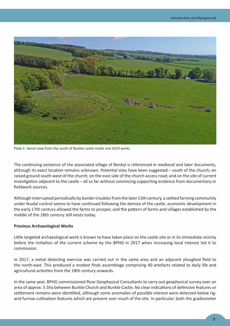
Figure 3: Bunkle Castle as marked on the OS 1st edition 6 inch map of Berwickshire, Sheet X, Surveyed: 1857, Published: 1862
Introduction and Background
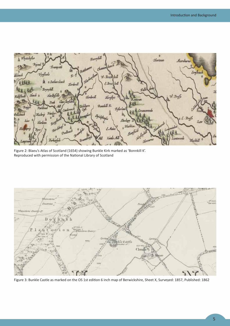
Figure 2: Blaeu’s Atlas of Scotland (1654) showing Bunkle Kirk marked as ‘Bonnkill K’. Reproduced with permission of the National Library of Scotland
6
Introduction and Background
Plate 1: Aerial view from the south of Bunkle castle motte and 2019 works
The continuing existence of the associated village of Bonkyl is referenced in medieval and later documents, although its exact location remains unknown. Potential sites have been suggested – south of the church; on raised ground south-west of the church; on the east side of the church access road; and on the site of current investigation adjacent to the castle – all so far without convincing supporting evidence from documentary or fieldwork sources.
Although interrupted periodically by border troubles from the later 13th century, a settled farming community under feudal control seems to have continued following the demise of the castle. economic development in the early 17th century allowed the farms to prosper, and the pattern of farms and villages established by the middle of the 18th century still exists today.
Previous Archaeological Works
Little targeted archaeological work is known to have taken place on the castle site or in its immediate vicinity before the initiation of the current scheme by the BPHG in 2017 when increasing local interest led it to commission.
In 2017, a metal detecting exercise was carried out in the same area and an adjacent ploughed field to the north-east. This produced a modest finds assemblage comprising 40 artefacts related to daily life and agricultural activities from the 18th century onwards.
In the same year, BPHG commissioned Rose Geophysical Consultants to carry out geophysical survey over an area of approx. 5.5ha between Bunkle Church and Bunkle Castle. No clear indications of defensive features or settlement remains were identified, although some anomalies of possible interest were detected below rig-and-furrow cultivation features which are present over much of the site. In particular, both the gradiometer
7
Introduction and Background
and resistance surveys identified anomalies just to the south-east of the castle which, it was suggested, would benefit from further study.
In May 2018, BPHG carried out exploratory trenching, testing some of the anomalies revealed in 2018. Trench 1, excavated south of the south gate of the castle in a position designed to intercept any ribbon development along a putative N-S road out of the castle, exposed the boulder-clay subsoil at very shallow depths, revealing no features save for a modern pipe trench.
Trench 2 was positioned to examine an apparent terrace forming the western slope into a dry valley, now marked by the course of a modern water pipe. A strip trench revealed deep deposits of topsoil overlying a moist, silty subsoil in which were seen a curving line of over 30 truncated wooden posts of ash, alder, and oak. Subsequent widening of the trench exposed more of the curving line of posts and, also, the remains of additional posts which may form a parallel line to the south. The southern line contained wattle infill, although only a short section was revealed, making its relation to the northern line unclear.
A small assemblage of pottery was also recovered from Trench 2, mostly apparently of 14th/15th century origin and also a significant assemblage of reduced greenware with applied and impressed decoration, perhaps all from one vessel. Several white/buff firing fabrics were also recovered, including one strap handle fragment, in buff fabric with grey core, an everted rim in relatively fine fabric and several green-glazed body sherds.
Palaeo-environmental analysis of samples from the waterlogged deposit forming the base of T2 provided evidence for waterlogged preservation, with indications that the feature held standing water at least periodically. A small charred assemblage of organic material is characteristic of domestic hearth waste and included cereal crops typical of medieval and post-medieval sites, while a grape pip reflects the use of imported dried fruits at the site. Radiocarbon dating of material derived from palaeo-environmental analysis produced the following dates from two samples, suggesting very early, potentially pre-Conquest occupation of the site:
o Waterlogged wood from silty deposit (equivalent to BK19 (207)): 1267-1381 AD (95% prob.)
o Charred grain from silty deposit (equivalent to BK19 (207)) between lines of posts at west end: 1032-1157 AD (95% prob.)
Trench 3 was placed on a slight ridge in the north-central part of the site to investigate an anomaly identified in the geophysical survey, but produced no results of significance, encountering subsoil at very shallow depths.
Trench 4 was excavated in the east part of the site to investigate an area of geophysical anomaly adjacent to the churchyard. Excavation here encountered worked stone rubble at very shallow depths, some of which may be the remains of a built structure, but time constraints prevented full exploration of these remains and no diagnostic evidence was found for its date of origin.
Objectives of Works in 2019
The excavations took place on the east and south-east sides of Bunkle Castle, between the south-east side of the castle moat and the east side of the churchyard wall, a linear distance of some 300m. The objective of the fieldwork programme was to identify and record any archaeological features uncovered during groundworks, with the intention of adding to knowledge previously gained through documentary work by BPHG members of medieval settlement at Bunkle.
0 20 40 60 80 100 120 140 160 180 200M
138.7m
163.7m
160.9m
160.9m
Drain?
edge of ditch?
edge of deep ditch?
edge of deep ditch?
bottom of deep ditch?
top of cut?
base of cut?
top & bottom of cut?
top & bottom of cut?
top of slope?
bottom
of shallow
cut
Stones
10M
Castle
T2
T5
T6
T7
T8
T9
T4T10
T11
Fnc.
Fnc.
Ch.
KEY: 2019 trenches
2018 trenches
8
Archaeological Investigations
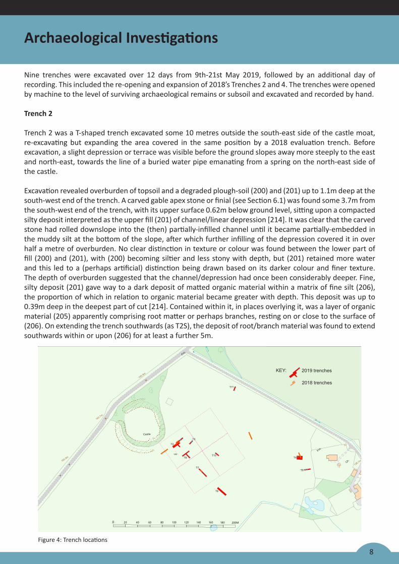
Nine trenches were excavated over 12 days from 9th-21st May 2019, followed by an additional day of recording. This included the re-opening and expansion of 2018’s Trenches 2 and 4. The trenches were opened by machine to the level of surviving archaeological remains or subsoil and excavated and recorded by hand.
Trench 2
Trench 2 was a T-shaped trench excavated some 10 metres outside the south-east side of the castle moat, re-excavating but expanding the area covered in the same position by a 2018 evaluation trench. Before excavation, a slight depression or terrace was visible before the ground slopes away more steeply to the east and north-east, towards the line of a buried water pipe emanating from a spring on the north-east side of the castle.
Excavation revealed overburden of topsoil and a degraded plough-soil (200) and (201) up to 1.1m deep at the south-west end of the trench. A carved gable apex stone or finial (see Section 6.1) was found some 3.7m from the south-west end of the trench, with its upper surface 0.62m below ground level, sitting upon a compacted silty deposit interpreted as the upper fill (201) of channel/linear depression [214]. It was clear that the carved stone had rolled downslope into the (then) partially-infilled channel until it became partially-embedded in the muddy silt at the bottom of the slope, after which further infilling of the depression covered it in over half a metre of overburden. No clear distinction in texture or colour was found between the lower part of fill (200) and (201), with (200) becoming siltier and less stony with depth, but (201) retained more water and this led to a (perhaps artificial) distinction being drawn based on its darker colour and finer texture. The depth of overburden suggested that the channel/depression had once been considerably deeper. Fine, silty deposit (201) gave way to a dark deposit of matted organic material within a matrix of fine silt (206), the proportion of which in relation to organic material became greater with depth. This deposit was up to 0.39m deep in the deepest part of cut [214]. Contained within it, in places overlying it, was a layer of organic material (205) apparently comprising root matter or perhaps branches, resting on or close to the surface of (206). On extending the trench southwards (as T2S), the deposit of root/branch material was found to extend southwards within or upon (206) for at least a further 5m.
Figure 4: Trench locations
9
Archaeological Investigations
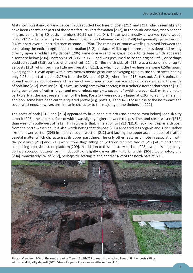
Plate 4: View from NW of the central part of Trench 2 with T2S to rear, showing two lines of timber posts sitting within reddish, silty deposit (207). View of a part of post-and-wattle feature [212].
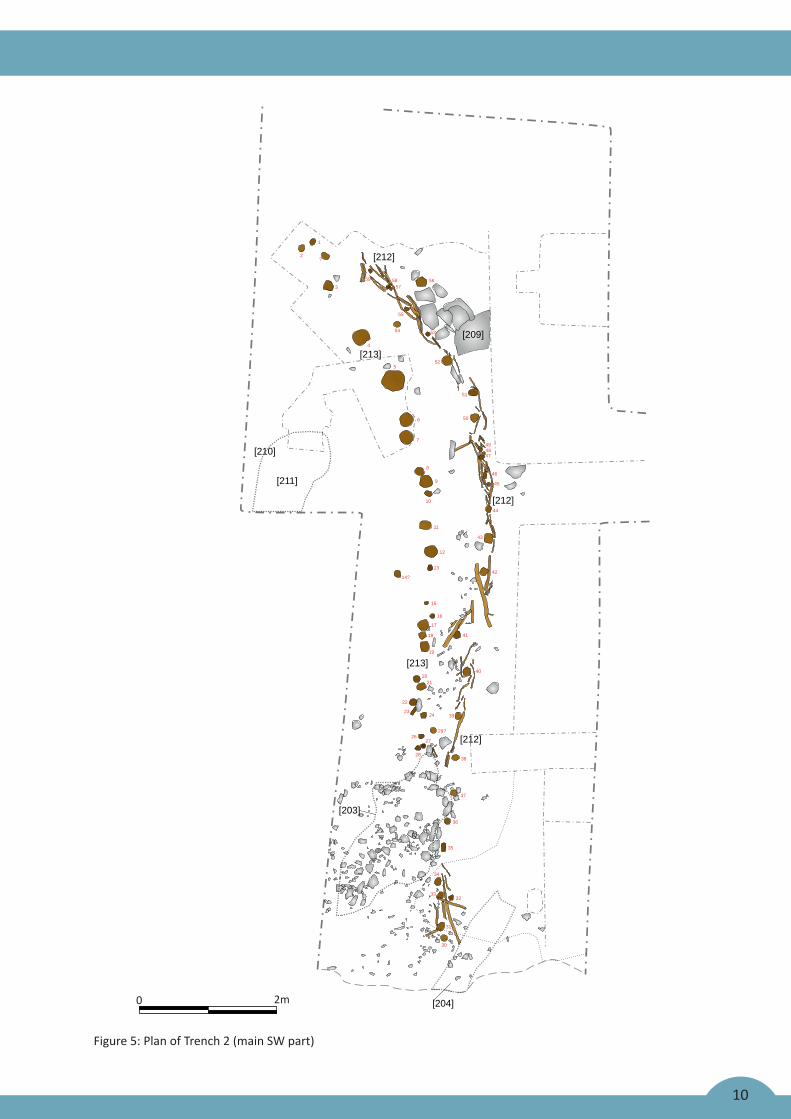
At its north-west end, organic deposit (205) abutted two lines of posts [212] and [213] which seem likely to have been constituent parts of the same feature. Post formation [212], in the south-east side, was S-shaped in plan, comprising 30 posts (numbers 30-59 on Illus. 04). These were mostly unworked round-wood, 0.06m-0.12m diameter, in places clustered together (as between posts 44 & 49) but generally spaced around 0.40m apart over a linear distance of some 11.75m. The remains of coarse wattling survived between the posts along the entire length of post formation [212], in places visible up to three courses deep and resting directly upon a reddish silty deposit (206) some coarse sand or gravel close to its base which appeared elsewhere below (206) - notably SE of [212] in T2S - and was presumed to be the original infill, or perhaps puddled subsoil (215) surface of channel cut [214]. On the north side of [212] was a second line of up to 29 posts [213] which begins a little north-east of [212], at which point the two lines are some 0.50m apart, diverging to c. 0.85m apart within two metres before gradually converging again to the south-west, ending only 0.25m apart at a point 2.75m from the SW end of [212], where line [213] runs out. At this point, the ground becomes much stonier and may once have formed a rough surface (203) which extended to the inside of post line [212]. Post line [213], as well as being somewhat shorter, is of a rather different character to [212] being comprised of rather larger and more robust uprights, several of which are over 0.15 m in diameter, particularly at the north-eastern half of the line. Posts 5-7 were notably larger at 0.20m-0.28m diameter. In addition, some have been cut to a squared profile (e.g. posts 3, 9 and 14). Those close to the north-east and south-west ends, however, are similar in character to the majority of the timbers in [212].
The posts of both [212] and [213] appeared to have been cut into (and perhaps even below) reddish silty deposit (207), the upper surface of which was slightly higher between the post lines and north-west of [213] than west or south-west of [212]. This suggests that, in relation to [212]/[213], (207) built up as a deposit from the north-west side. It is also worth noting that deposit (206) appeared less organic and siltier, rather like the lower part of (206) in the area south-west of [212] and lacking the upper accumulation of matted vegetal matter which characterises its upper part there. The only other features of note in association with the post lines [212] and [213] were stone flags sitting on (207) on the east side of [212] at its north end, comprising a possible stone platform [209]. In addition to this and stony surface (203), two possible, poorly-defined scooped features, or infill deposits of slightly darker silty material within (206), were noted, one [204] immediately SW of [212], perhaps truncating it, and another NW of the north part of [213].
0 2m
474849
50
51
52
5354
5
4
3
1
2?
6
7
8
9
10
11
12
13
15
16
17
18
19
35
34
3332
31
30
36
29?
37
38
39
40
41
42
43
44
45
46
2120
22
2324
2627
28
14?
55
575859 56
[204]
[203]
[211]
[210]
[212]
[212]
[213]
[213]
[212]
[209]
10
Figure 5: Plan of Trench 2 (main SW part)
11
Archaeological Investigations
Trench 2 was extended to the north-east end, to investigate a slight N-S raised linear earthwork which it was thought might define the edge of channel cut [214]. In fact, the channel edge subsequently traced to a point just north-east of the north ends of [212] & [213], whereas the additional slip trench somewhat surprisingly revealed a ditch cut [210], 2.7m wide and up to 0.80m deep, running underneath and parallel with the slightly raised linear earthwork. The primary fill of the ditch was a dense, dark silty deposit (208) containing some preserved roundwood twigs, below a secondary deposit of silty loam (202). No further features were revealed beyond this to the north-east, the top-soil overburden giving way at 0.25m-30m depth to the natural subsoil (215) (or, potentially, compacted deposited subsoil).
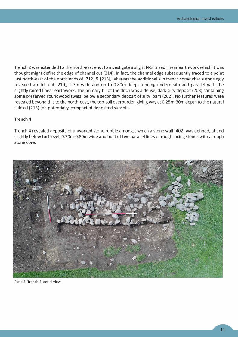
Trench 4
Trench 4 revealed deposits of unworked stone rubble amongst which a stone wall [402] was defined, at and slightly below turf level, 0.70m-0.80m wide and built of two parallel lines of rough facing stones with a rough stone core.
Plate 5: Trench 4, aerial view
12
Archaeological Investigations
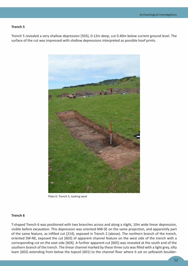
Trench 5
Trench 5 revealed a very shallow depression [503], 0.12m deep, cut 0.40m below current ground level. The surface of the cut was impressed with shallow depressions interpreted as possible hoof prints.
Plate 6: Trench 5, looking west
Trench 6
T-shaped Trench 6 was positioned with two branches across and along a slight, 10m wide linear depression, visible before excavation. This depression was oriented NW-SE on the same projection, and apparently part of the same feature, as infilled cut [214], exposed in Trench 2 (above). The northern branch of the trench, oriented SW-NE, exposed the cut [603] of apparent channel feature on the west side of the trench with a corresponding cut on the east side [604]. A further apparent cut [605] was revealed at the south end of the southern branch of the trench. The linear channel marked by these three cuts was filled with a light grey, silty loam (602) extending from below the topsoil (601) to the channel floor where it sat on yellowish boulder-
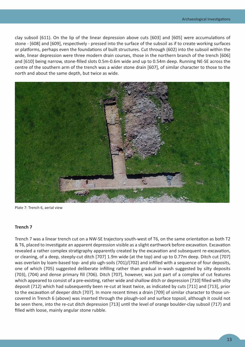
13
Archaeological Investigations
clay subsoil (611). On the lip of the linear depression above cuts [603] and [605] were accumulations of stone - [608] and [609], respectively - pressed into the surface of the subsoil as if to create working surfaces or platforms, perhaps even the foundations of built structures. Cut through (602) into the subsoil within the wide, linear depression were three modern drain courses, those in the northern branch of the trench [606] and [610] being narrow, stone-filled slots 0.5m-0.6m wide and up to 0.54m deep. Running NE-SE across the centre of the southern arm of the trench was a wider stone drain [607], of similar character to those to the north and about the same depth, but twice as wide.
Plate 7: Trench 6, aerial view
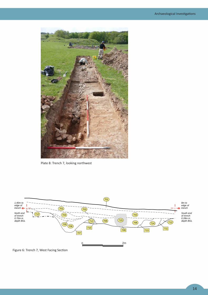
Trench 7
Trench 7 was a linear trench cut on a NW-SE trajectory south-west of T6, on the same orientation as both T2 & T6, placed to investigate an apparent depression visible as a slight earthwork before excavation. Excavation revealed a rather complex stratigraphy apparently created by the excavation and subsequent re-excavation, or cleaning, of a deep, steeply-cut ditch [707] 1.9m wide (at the top) and up to 0.77m deep. Ditch cut [707] was overlain by loam-based top- and plo ugh-soils (701)/(702) and infilled with a sequence of four deposits, one of which (705) suggested deliberate infilling rather than gradual in-wash suggested by silty deposits (703), (704) and dense primary fill (706). Ditch [707], however, was just part of a complex of cut features which appeared to consist of a pre-existing, rather wide and shallow ditch or depression [710] filled with silty deposit (712) which had subsequently been re-cut at least twice, as indicated by cuts [711] and [713], prior to the excavation of deeper ditch [707]. In more recent times a drain [709] of similar character to those un-covered in Trench 6 (above) was inserted through the plough-soil and surface topsoil, although it could not be seen there, into the re-cut ditch depression [713] until the level of orange boulder-clay subsoil (717) and filled with loose, mainly angular stone rubble.
0 2m
7018m toedge oftrench
South endof trench0.28m indepth BGL
701
712 704
705706
703
702
712 708708 714 712
707
710713709
711
1.40m toedge oftrench
North endof trench0.70m indepth BGL 715
14
Archaeological Investigations
Plate 8: Trench 7, looking northwest
Figure 6: Trench 7, West Facing Section
0 2m
N
Machining
902 904
903907
905
900 ?
901
904 906902
905 907905903
15
Archaeological Investigations
Trench 8
Trench 8 was excavated south-east of Trench 7 to investigate an apparent roadway running E-W across the south part of the field. The roadway [803] was found to be an ad hoc modern construction directly upon the subsoil, containing modern brick and tile at its surface with no indication that earlier surfaces had existed be-neath. A stone drain [804] cut into the subsoil ran through the centre of the trench from NW to SE.
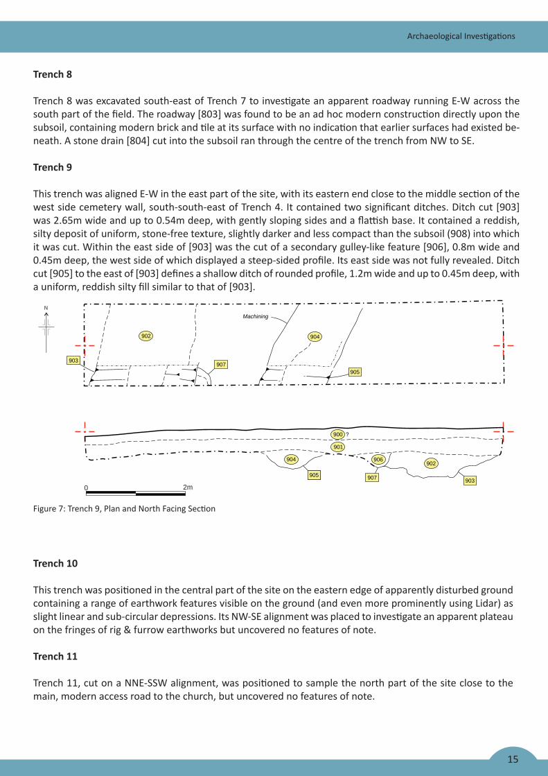
Trench 9
This trench was aligned E-W in the east part of the site, with its eastern end close to the middle section of the west side cemetery wall, south-south-east of Trench 4. It contained two significant ditches. Ditch cut [903] was 2.65m wide and up to 0.54m deep, with gently sloping sides and a flattish base. It contained a reddish, silty deposit of uniform, stone-free texture, slightly darker and less compact than the subsoil (908) into which it was cut. Within the east side of [903] was the cut of a secondary gulley-like feature [906], 0.8m wide and 0.45m deep, the west side of which displayed a steep-sided profile. Its east side was not fully revealed. Ditch cut [905] to the east of [903] defines a shallow ditch of rounded profile, 1.2m wide and up to 0.45m deep, with a uniform, reddish silty fill similar to that of [903].
Figure 7: Trench 9, Plan and North Facing Section
Trench 10
This trench was positioned in the central part of the site on the eastern edge of apparently disturbed ground containing a range of earthwork features visible on the ground (and even more prominently using Lidar) as slight linear and sub-circular depressions. Its NW-SE alignment was placed to investigate an apparent plateau on the fringes of rig & furrow earthworks but uncovered no features of note.
Trench 11
Trench 11, cut on a NNE-SSW alignment, was positioned to sample the north part of the site close to the main, modern access road to the church, but uncovered no features of note.
16
Artefacts
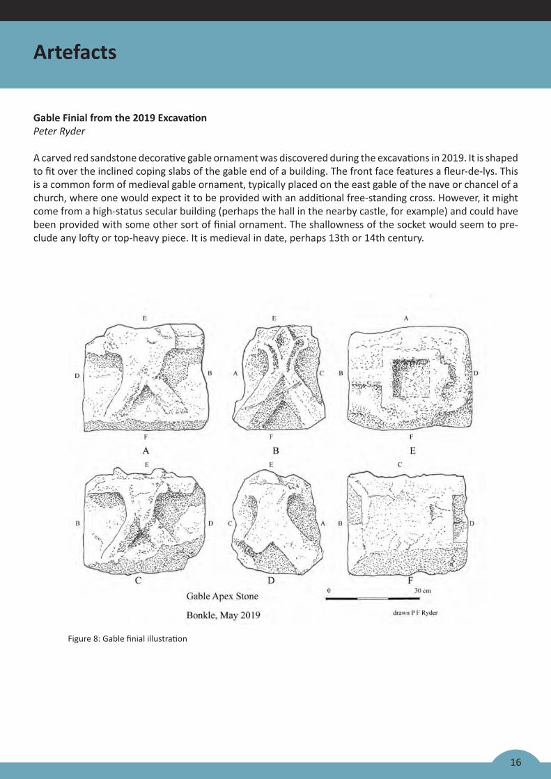
Figure 8: Gable finial illustration
Gable Finial from the 2019 ExcavationPeter Ryder
A carved red sandstone decorative gable ornament was discovered during the excavations in 2019. It is shaped to fit over the inclined coping slabs of the gable end of a building. The front face features a fleur-de-lys. This is a common form of medieval gable ornament, typically placed on the east gable of the nave or chancel of a church, where one would expect it to be provided with an additional free-standing cross. However, it might come from a high-status secular building (perhaps the hall in the nearby castle, for example) and could have been provided with some other sort of finial ornament. The shallowness of the socket would seem to pre-clude any lofty or top-heavy piece. It is medieval in date, perhaps 13th or 14th century.
17
Artefacts
Chipped StoneRob Engl
A single secondary flint flake was retrieved from the second phase of works undertaken at Bunkle. The flake was white in colour with evidence of burning in the form of crazing. The flake had a simple corticated striking platform and a pronounced bulb of percussion.
Dimensions; 10.5mm x 22.5mm x 5.6mm
The Metal-Detected FindsAndrew Morrison
A total of 40 finds from metal-detecting surveys span in date from the medieval to modern periods, the majority being 18th century or later in origin. They represent the remains of daily living, casual losses and the remains of agricultural activities and refuse incorporated into the plough-soils.
The Medieval PotteryGeorge R. Haggarty
The medieval pottery assemblage from Bunkle comprised around 130 sherds, a significant amount of which are from unstratified contexts.
During the high medieval period, in ceramic terms, Bunkle village lay within the Scottish White Gritty Ware (SWGW) tradition. White Gritty fabrics are usually hard with a quite finely grained matrix, often encompassing a range of rock fragments and inclusions which makes them gritty to the touch. In colour the vessels range, when oxidised, from the very common white or cream to the occasional buff or pink. Fired under reduction, they are generally a light to medium grey, and occasionally almost black. The main vessel forms are jars/cooking pots and jugs, although a very limited range of other vessel types have been recorded. There is slight evidence for Scottish regionalism, especially in the 12th and 13th centuries, perhaps in the Borders, Lothian and Fife. Above the River Tay, pottery was usually produced from red firing clay. Rim morphology has proven to be almost ineffectual, with as many variations as vessels, while attempts to subdivide SWGW based on the size of its quartz tempering have merely resulted in lots of problematic sub-groups. Results from the Historic Scotland funded ICP-OES Scottish White Gritty Ware project suggests that many undiscovered production centres await discovery (Haggarty, Hall, & Jones 2012), but presently only three have been identified: at Colstoun in East Lothian (Brooks 1980; Hall 2007); Ceres (Jones et al 2003; GSB 2014) and Coaltown of Wemyss in Fife (AOC Archaeology unpub.).
We still have much to learn on the dating of SWGW, but it is generally accepted that Scotland’s wheel-thrown ceramic industry was introduced along with monasticism, probably in the second quarter of the 12th century (Haggarty 1984, 395-8). Confirmation for this date is still lacking, but there is good evidence that the industry was flourishing by the third quarter of the century.
It may be that good white surface clays were used up by the 15th century or that there was a change fashion – at any rate, Scottish pottery produced using white clays all but disappear after this time. Unfortunately, most of the SWGW sherds from Bunkle are unstratified and in the main small and without a small program of ICP chemical analysis it’s impossible to suggest an area of production or indeed a close date, but almost certainly all were produced between the late 12th and 14th centuries.
18
Artefacts
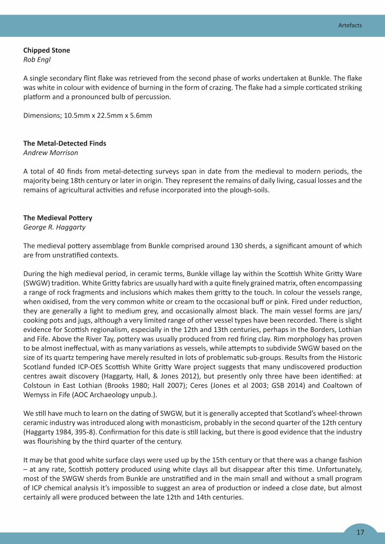
Medieval Imports
Somewhat similar white gritty wares were also produced in the North East of England and by the late 12th century, jugs decorated with a copper rich lead suspension glaze were exported north from Yorkshire in some quantity. In particular this was to the large east coast burghs, but sherds can be found in most Scottish east coast medieval assemblages especially those dating from c. AD 1250-AD 1350. In particular, Brandsby type and York glazed wares seem to dominate this trade (Jennings 1992, 18-25). The proportion of possible Yorkshire vessels recovered from Bunkle is quite high at 10 finds in total.
Among the material from Bunkle was an assemblage of 36 sherds (SF 14), of which 31 conjoin to form the rim, neck, shoulder and strap handle of a jug in an off-white lightly sandy and slightly gritty fabric covered with a light green suspension glaze. The interior has a large grey reduced area and the exterior has been decorated with 16 bands of chequered rouletting. This is almost certainly a 13th or 14th century Yorkshire import, possibly from the Brandsby area where kiln material has been identified (Le Patourel 1979).
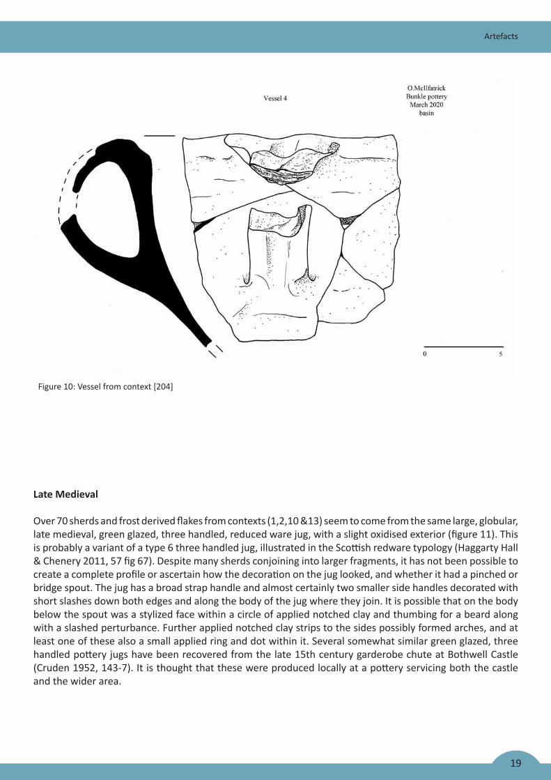
From context [204] are five sherds which conjoin to form a large fragment of a thick, crudely made, handled vessel with a light green lead glaze on the lower part of its interior, and sooting on its exterior. The red sandy fabric has a reduced core and no visible large inclusions. It is somewhat similar in appearance to late 16th century, Scottish Post Medieval Oxidised Wares, but given that the rest of the pottery sherds in the context are medieval, this vessel may be from an as yet unidentified Scottish kiln site or possibly an English import.
Figure 9: Impoted Medieval Pottery
19
Artefacts
Late Medieval
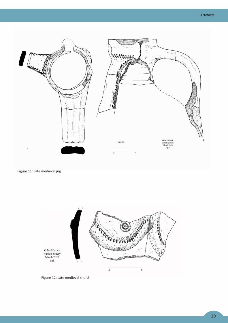
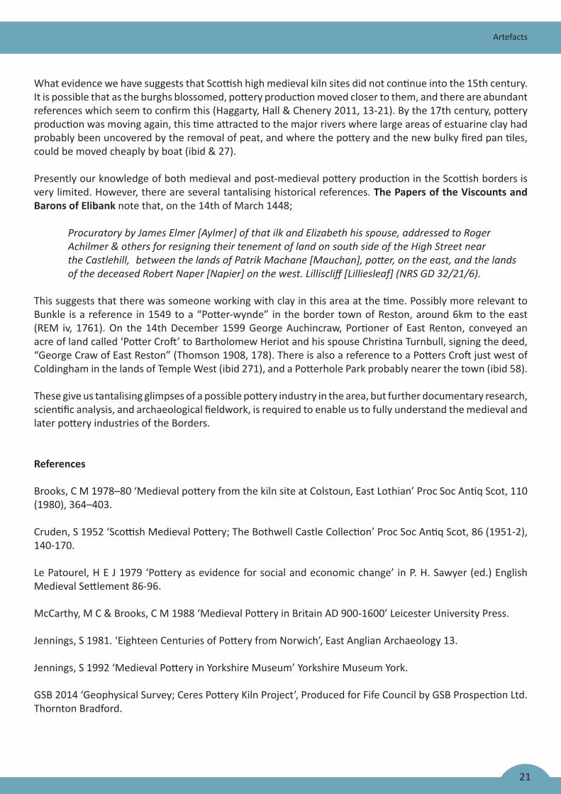
Over 70 sherds and frost derived flakes from contexts (1,2,10 &13) seem to come from the same large, globular, late medieval, green glazed, three handled, reduced ware jug, with a slight oxidised exterior (figure 11). This is probably a variant of a type 6 three handled jug, illustrated in the Scottish redware typology (Haggarty Hall & Chenery 2011, 57 fig 67). Despite many sherds conjoining into larger fragments, it has not been possible to create a complete profile or ascertain how the decoration on the jug looked, and whether it had a pinched or bridge spout. The jug has a broad strap handle and almost certainly two smaller side handles decorated with short slashes down both edges and along the body of the jug where they join. It is possible that on the body below the spout was a stylized face within a circle of applied notched clay and thumbing for a beard along with a slashed perturbance. Further applied notched clay strips to the sides possibly formed arches, and at least one of these also a small applied ring and dot within it. Several somewhat similar green glazed, three handled pottery jugs have been recovered from the late 15th century garderobe chute at Bothwell Castle (Cruden 1952, 143-7). It is thought that these were produced locally at a pottery servicing both the castle and the wider area.
Figure 10: Vessel from context [204]
20
Artefacts
Figure 11: Late medieval jug
Figure 12: Late medieval sherd
21
Artefacts
What evidence we have suggests that Scottish high medieval kiln sites did not continue into the 15th century. It is possible that as the burghs blossomed, pottery production moved closer to them, and there are abundant references which seem to confirm this (Haggarty, Hall & Chenery 2011, 13-21). By the 17th century, pottery production was moving again, this time attracted to the major rivers where large areas of estuarine clay had probably been uncovered by the removal of peat, and where the pottery and the new bulky fired pan tiles, could be moved cheaply by boat (ibid & 27).
Presently our knowledge of both medieval and post-medieval pottery production in the Scottish borders is very limited. However, there are several tantalising historical references. The Papers of the Viscounts and Barons of Elibank note that, on the 14th of March 1448;
Procuratory by James Elmer [Aylmer] of that ilk and Elizabeth his spouse, addressed to Roger Achilmer & others for resigning their tenement of land on south side of the High Street near theCastlehill,betweenthelandsofPatrikMachane[Mauchan],potter,ontheeast,andthelands ofthedeceasedRobertNaper[Napier]onthewest.Lilliscliff[Lilliesleaf](NRSGD32/21/6).
This suggests that there was someone working with clay in this area at the time. Possibly more relevant to Bunkle is a reference in 1549 to a “Potter-wynde” in the border town of Reston, around 6km to the east (REM iv, 1761). On the 14th December 1599 George Auchincraw, Portioner of East Renton, conveyed an acre of land called ‘Potter Croft’ to Bartholomew Heriot and his spouse Christina Turnbull, signing the deed, “George Craw of East Reston” (Thomson 1908, 178). There is also a reference to a Potters Croft just west of Coldingham in the lands of Temple West (ibid 271), and a Potterhole Park probably nearer the town (ibid 58).
These give us tantalising glimpses of a possible pottery industry in the area, but further documentary research, scientific analysis, and archaeological fieldwork, is required to enable us to fully understand the medieval and later pottery industries of the Borders.
References
Brooks, C M 1978–80 ‘Medieval pottery from the kiln site at Colstoun, East Lothian’ Proc Soc Antiq Scot, 110 (1980), 364–403.
Cruden, S 1952 ‘Scottish Medieval Pottery; The Bothwell Castle Collection’ Proc Soc Antiq Scot, 86 (1951-2), 140-170.
Le Patourel, H E J 1979 ‘Pottery as evidence for social and economic change’ in P. H. Sawyer (ed.) English Medieval Settlement 86-96.
McCarthy, M C & Brooks, C M 1988 ‘Medieval Pottery in Britain AD 900-1600’ Leicester University Press.
Jennings, S 1981. ‘Eighteen Centuries of Pottery from Norwich’, East Anglian Archaeology 13.
Jennings, S 1992 ‘Medieval Pottery in Yorkshire Museum’ Yorkshire Museum York.
GSB 2014 ‘Geophysical Survey; Ceres Pottery Kiln Project’, Produced for Fife Council by GSB Prospection Ltd. Thornton Bradford.
22
Artefacts
Haggarty, G 1984 ‘Observations on the ceramic material from phase 1 pits BY and AQ’ in Tabraham, C ‘Excavations at Kelso Abbey’ Proc Soc Antiq Scot, 114 (1984), 395–7.
Haggarty, G & Will, R 1995 ‘The Pottery’ in Lewis, J and Ewart, G (eds) ‘Jedburgh Abbey: the archaeology and architecture of a Border Abbey’, 117–130. Edinburgh (= Soc Antiq Scot Monogr Ser, 10) 98-105.
Haggarty, G Hall, D & Chenery, S 2011 ‘Sourcing Scottish redwares’ Medieval Pottery Research Group, Occasional Paper 5.
Haggarty, G Hall, D W & Jones, R 2012 ‘Sourcing Scottish medieval ceramics-the use and success of chemical analysis’ Proc Soc Antiq Scot Vol 141 (2011), 249-267.
Hall, D W 2007 ‘Excavations at the pottery production centre of Colstoun, East Lothian in 1939, 1969, 1971, 1977 and 1999/2000’ Medieval Ceramics 28 (2004) 34–73.
Holmes, N Mc 1995, ‘Coins’ in Lewis, J and Ewart, G (eds) ‘Jedburgh Abbey: the archaeology and architecture of a Border Abbey’, 117–130. Edinburgh (= Soc Antiq Scot Monogr Ser, 10) 94.
Jones, R Will, B Haggarty, G and Hall, D 2003 Sourcing Scottish white gritty ware’ Medieval Ceramics 26 and 27, (2002–3), 45–84.
National Records Scotland; GD 32/21/6.
REM: Thomson, J M et al (eds) 1882–1914 Registrum Magni Sigilli Regum Scotorum, 11 vols, Edinburgh (reprinted 1984).
Thomson, A 1908 ‘Coldingham Parish & Priory’, Craighead Brothers Galashiels.
23
The Palaeoenvironmental Evidence
Waterlogged WoodAnne Crone and Alex Wood
An assemblage of waterlogged wood from Trenches 2 and 7 was analysed. The assemblage was recorded and catalogued, a sub-sample were identified to species, and an oak sample was dendrochronologically dated. The results are reported here and incorporated with the results from earlier investigations, by Charlotte O’Brien (2018) and Coralie Mills (2020).
Trench 2
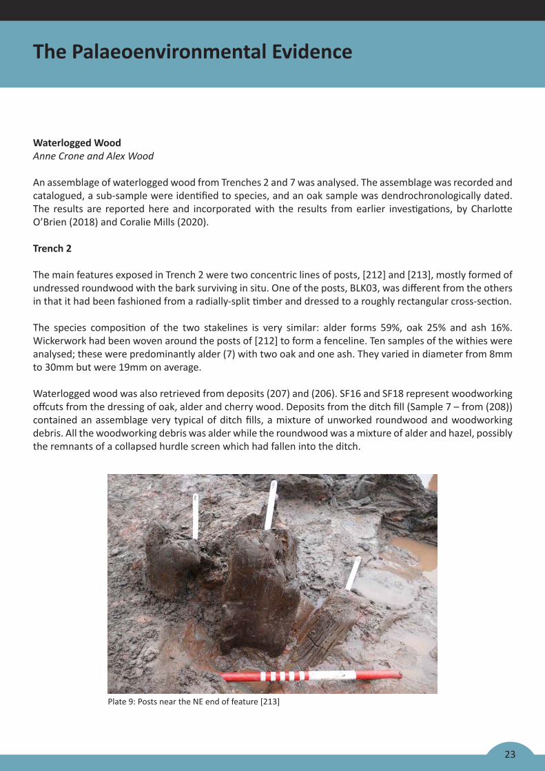
The main features exposed in Trench 2 were two concentric lines of posts, [212] and [213], mostly formed of undressed roundwood with the bark surviving in situ. One of the posts, BLK03, was different from the others in that it had been fashioned from a radially-split timber and dressed to a roughly rectangular cross-section.
The species composition of the two stakelines is very similar: alder forms 59%, oak 25% and ash 16%. Wickerwork had been woven around the posts of [212] to form a fenceline. Ten samples of the withies were analysed; these were predominantly alder (7) with two oak and one ash. They varied in diameter from 8mm to 30mm but were 19mm on average.
Waterlogged wood was also retrieved from deposits (207) and (206). SF16 and SF18 represent woodworking offcuts from the dressing of oak, alder and cherry wood. Deposits from the ditch fill (Sample 7 – from (208)) contained an assemblage very typical of ditch fills, a mixture of unworked roundwood and woodworking debris. All the woodworking debris was alder while the roundwood was a mixture of alder and hazel, possibly the remnants of a collapsed hurdle screen which had fallen into the ditch.
Plate 9: Posts near the NE end of feature [213]
24
The Palaeoenvironmental Evidence
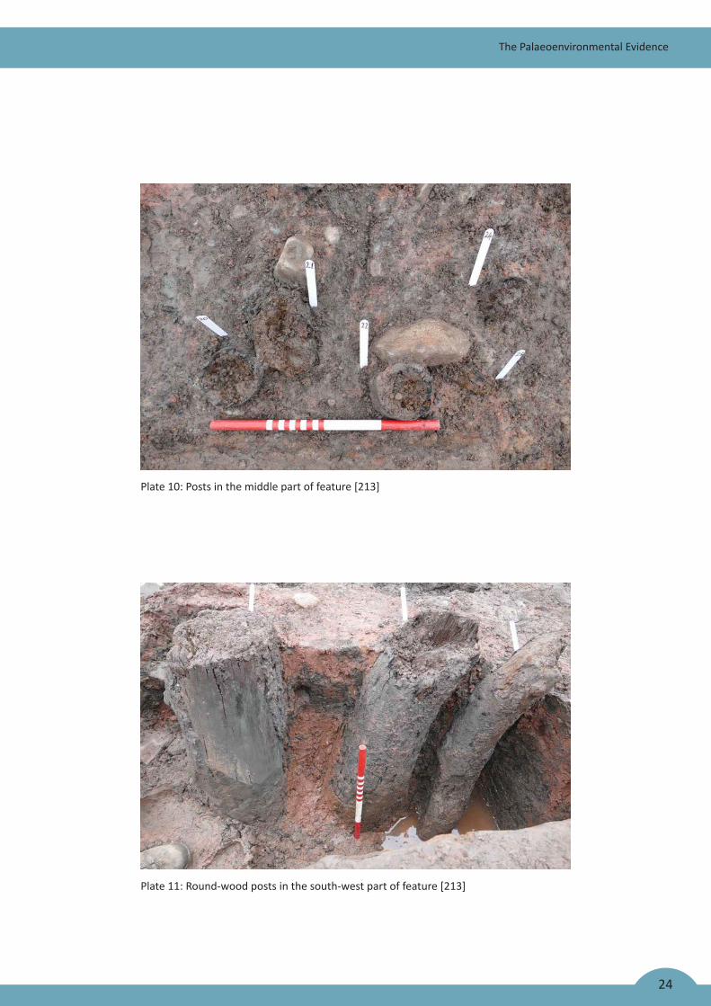
Plate 10: Posts in the middle part of feature [213]
Plate 11: Round-wood posts in the south-west part of feature [213]
25
The Palaeoenvironmental Evidence
Trench 7
All the waterlogged wood from this trench came from the ditch fill. The three samples contain a mixture of unworked roundwood, a sub-sample of which was identified as alder and cherry, and woodworking offcuts, a sub-sample of which was identified as oak. Some of the roundwood had been burnt before deposition in the ditch.
Dendrochronological analysis
Dendrochronological analysis was undertaken on two pieces of wood: BLK03, one of the posts from inner line [213] was analysed by Coralie Mills (2020); and a sample ‘top of post 3’ was analysed by AOC. It seems likely to have come from the same post as BLK03; there are no sawmarks on either end so it may have rotted off the top of the post and come to rest beside it. Dendrochronological analysis supports this: the two sequences correlated very strongly with each other and a mean chronology, 112 years in length, was constructed. This was compared against a suite of dated reference chronologies from the British Isles, northern Europe and Scandinavia. It produced consistent correlations with many northern European chronologies dating it to AD 1479-AD 1590. The highest correlations were with chronologies from Germany so it is likely that this timber was imported. Almost all building timber was being imported into Scotland by this time but it was mostly coming from Scandinavia (Crone & Mills 2012; Crone et al 2017); the Bunkle oak post is currently the only identified example of German timber in Scotland.
The post had been squared, removing all sapwood and possibly some heartwood. A terminus post quem for the felling of the oak is calculated by adding a minimum number of sapwood rings to the outermost ring, and as Germany was the likely source of the timbers a sapwood estimate of 10-30 rings is used (Haneca et al 2009, 5), meaning that the oak was probably felled sometime after AD 1600. However, it is possible that the timber had been re-used, in which case the post could have been inserted much later.
References
Crone, B A & Mills, CM 2012 ‘Timber in Scottish buildings, 1450 - 1800; a dendrochronological perspective’, Proc Soc Antiq Scot 142, 329-69.
Crone, A, Bath, M & Pearce, M 2017 The dendrochronology and art history of a sample of 16th and 17th Century painted ceilings. Historic Environment Scotland Research Report. https://www.historicenvironment.scot/archives-and-research/publications/publication/?publicationId=535234b2-8dc1-42f8-8d1b-a73600c76fee
Mills, C 2020 SESOD report.
O’Brien, C 2018 Palaeoenvironmental assessment. ASDU [Report 4939]
Haneca, K, Cufar, K & Beeckman, H 2009 ‘Oaks, tree-rings and wooden cultural heritage: a review of the main characteristics and applications of oak dendrochronology in Europe’, Journ. Archaeological Science 36, 1–11.
26
The Palaeoenvironmental Evidence
Sediment Assessment Report
Four sediment samples were collected in monolith tins from Trench 2, collecting the main deposits in their stratigraphic sequence so that they may be characterised, and the main formation processes of these sedi-ments may be identified.
The sample sequence examined provided evidence for a range of site formation processes including delib-erate dumping of deposits, and gradual infilling during periods in which the ditch was left open. Contexts (017/13) and (017/17) were formed within an open vegetated area in damp conditions exacerbated by the ditch in which the deposits were located. It is likely that the major post-burial modification of ditch sediments was through faunal activity and through mobilisation and deposition of iron and manganese (Lindbo et al 2010).
The ditch excavated within Trench 17 has experienced multiple phases of use, discard, re-use and acciden-tal or intentional infilling. The fill of the ditch bears testimony to a range of formation processes. However, despite evidence for a deeply stratified sequence of ditch infill depoists, there were very few indicators of human activities; just rare charcoal flecks. No material of archaeological interest was recovered. No organic deposits, alluvium or peat were observed, proving the deposits from the ditch to be of limited palaeoenvi-ronmental interest.
References
British Geological Survey (BGS) (2019). Geology of Britain Viewer. URL: www.bgs.ac.uk/geologyofbritain.Date accessed: 16th September 2019.
Lindbo, D.L., Stolt, M.H. and Vepraskas, M.J 2010 Redoximorphic Features In Stoops, G Marcelineo, V and Mees F Interpretation of Micromorphological Features of Soils and Regoliths Elsevier, Oxford. 129-147.
Milek K B 2012 Floor formation processes and the interpretation of site activity areas: an ethnoarchaeologi-cal study of turf buildings at Thverá, northeast Iceland. J Anthropol Archaeol 31:119–137
Potten, S 2019 Dogger Bank Creyke Beck Offshore Wind Farms Data Structure Report Unpub grey lit. rept.
Tröels-Smith, J. 1955 Karakterisering af løse jordater (Characterisation of unconsolidated sediments),Danm. Geol. Unders., Ser IV 3, 73.
27
The Palaeoenvironmental Evidence
The Macroplant and Charcoal evidenceJackaline Robertson
Factual Data
Four bulk samples were submitted for environmental analyses from the excavation undertaken at Bunkle Village, Berwickshire. Three samples were collected from an organic deposit (206) in trench 2 and one from a ditch in trench 7 believed to date to the medieval period. The ecofact assemblage was composed of both waterlogged and carbonised macroplants along with a small assemblage of charcoal.
Cereal
The cereal assemblage was composed of hulled barley, bread/club wheat and oat which are all typical finds from medieval Scotland. Given the small size of this assemblage it is impossible to state which species, if any, was the more important and what their economic role within this site was. What can be ascertained is that these carbonised caryopses represent food and cooking residue which were deposited in context (206).
Nuts and fruits
Possible remains of food included hazelnut (represented by the shells), raspberry and blackberry, which were present in all three samples associated with context (206). Hazelnut shell is a common find at most archaeological sites as they were a popular and seasonally available food resource with the shells often exposed to heat during roasting. The shells were often recycled as a kindling material or disposed of in the fires during cleaning. The raspberry and blackberry like the hazelnut could have been collected deliberately as a source of food when it became seasonally available. It’s incorporation within samples from (206) could represent the disposal of faecal matter within this deposit along with other domestic refuse. Alternatively, raspberry and blackberry which grows wild could have been accidently deposited along with the other inva-sive weed taxa.
Woodland
Evidence of species of a woodland environment were noted in all four samples and included fragments of wood, alder fruits and buds. The waterlogged wood fragments from trench 2 could have formed part of the wattle structure located in this area although this could not be confirmed.
Weeds/Wasteground
The weed assemblage was varied and included plants which are found on a range of habitats. These includ-ed plants found growing in arable/waste grounds, damp wet landscapes and habitats with standing water. There is no evidence to suggest that any of these plants were collected deliberately for food, fuel or building. Instead these taxa were likely growing nearby in the surrounding landscape or in the standing water present in the ditches. The plant taxa from trench 2 which included both damp and aquatic species indicates that this ditch was consistently wet whereas the sample from trench 7 was more prone to periodic drying out as there was no evidence of any of these species.
Arable/wasteground species present comprised a mix of thistle, fat hen, hemp-nettle, cinquefoils, wild rad-ish, dock, elderberry, prickly sowthistle, common chickweed, chickweed and common nettle. These species were scattered among all four samples. These species likely grew nearby and were accidently deposited within these four samples.
28
The Palaeoenvironmental Evidence
Weed taxa which favour damp and aquatic habitats were concentrated within the three samples associated with trench 2. The species were sedge, blinks, pale periscaria, knotweed, buttercup and broad-leaved pond-weed. These species probably grew on the damp edges or within the wet confines of context (206).
Charcoal
40 fragments of charcoal were identified to species. Oak formed over 42% of the charcoal identified to spe-cies, followed by alder at 22.5%, with smaller amounts of birch, hazel, willow, alder and apple/hawthorn/rowan.
The charcoal assemblage is composed entirely of fuel debris which was scattered among these four deposits. The tree species would have been easily accessible to the medieval community living at Bunkle. Alder, birch and willow normally favour damper habitats, hazel tends to grow in hedgerows, oak will grow wherever the soil and climate will allow whereas apple/ hawthorn/rowan is likely to be found on more dry acidic soils (Linford 2009; Martynoga 2012).
References
Cappers R.T.J., Bekker R.M. and Jans J.E.A. (2006) Digital seed atlas of the Netherlands (Barkhuis Publishing and Groningen University Library, Groningen).
Jacomet, S. 2006. Identification of cereal remains from archaeological sites. (2nd ed) Archaeobotany Lab IPAS, Basel University.
Hather, J G, 2000 The identification of the Northern European Woods: a guide for archaeologists and con-servators. London.
Kenward, H. K., Hall, A. R. and Jones, A. K. G. (1980). A tested set of techniques for the extraction of plant and animal macrofossils from waterlogged archaeological deposits. Science and Archaeology 22, 3-15.
Linford, J. 2009. A concise guide to trees. Baker and Taylor (UK)Ltd, Bicester, Oxfordshire.
Martynoga, F. 2012. A handbook of Scotland’s Trees. (2nd ed) Saraband.
Stace,C. 2010. New Flora of the British Isles. 3rd Edition. Cambridge University Press.
Schweingruber, F H, 1990 Microscopic wood anatomy. Birmensdorf.
Stace, C, 2010 New Flora of the British Isles. Cambridge.
29
Discussions and Conclusions
Summary
Remains uncovered adjacent to Bunkle castle in 2019 added to the findings of a smaller excavation in 2018 in confirming the presence of channel and ditch-like features which appear, in origin, to date from as early as the early 12th century, but in some cases continued in use until as late as the early 16th century.
Foremost among these features was a channel-like feature, some 11m-13m wide, perhaps up to 48m long and at least 0.7m deep which runs on a NW-SE trajectory from the south-east side of the castle moat, with which it may once have been connected. Within this channel, running SW-NE across the north-east end of the excavated portion, is a feature comprising two lines of wooden posts, that on the SE side furnished with wattle infill, which has been dated by means of three radiocarbon dates to the 14th century. Dendrochronological analysis of a large oak post within this feature indicated Germany as a possible source fort the post, and produced a rather anomalous late 16th or early 17th-century date, which might indicate re-use of this feature in the 17th century or later.
It is clear that these two features were both in use in the 14th century and the channel, at least, remained open until at least the early 16th century. However, the combined functions of these features are rather more obscure. It does seem clear that the large, channel-like feature contained standing water for long periods and that deposits accumulated within it at different rates and were subject to varying levels of disturbance. Whilst other options remain open, including a defensive purpose perhaps associated with an early phase of the castle or previous use of the site, these characteristics all point to the use of the cut feature as a fish pond in the 13th and 14th century.
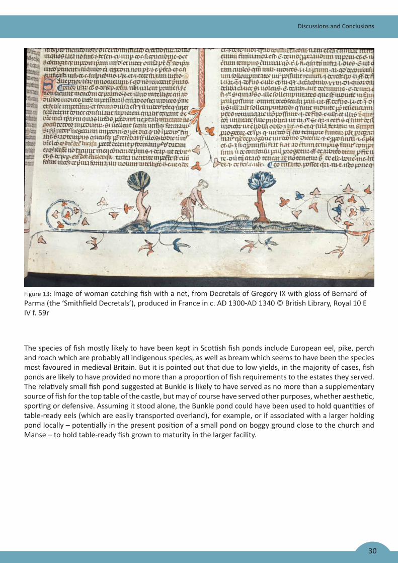
Fish played a vital part in the medieval diet as a relatively cheap source of protein and because of religious prohibitions on meat-eating. From the late 12th century, fish are frequently mentioned in accounts and court records. The number of fish pond sites claimed in Scotland is relatively small compared to England and Wales and it has even been suggested that medieval Scotland possessed no recognisable freshwater fish culture at all, but such features have nevertheless been identified at numerous medieval sites, including defensible ones.
Post feature comprising [212] & [213] is interpreted as perhaps some sort of barrier, perhaps as a combined barrier and walkway with planking nailed onto or across the upper surface of the uprights. It is possible (but unproven) that the channel and moat may once have been connected; in that case, it becomes possible to see the post feature as a barrier between the two, perhaps serving as a device to regulate water levels or related to fish management.
Fish ponds are usually recognised by a variety of physical and contextual factors (and documentary evidence, if available) but specific diagnostic features are rare. Amongst their potential physical features are water channels, sluices, spillways and dams for water management, as well as clay linings and wattle hurdles at entry and exits points or used as aids for fish catching. The Moravian engineer Dubravius (1559) specifically recommended strengthening dams with rows of stakes or posts of elm, oak or ash to contain a core of brushwood or clay.
30
The species of fish mostly likely to have been kept in Scottish fish ponds include European eel, pike, perch and roach which are probably all indigenous species, as well as bream which seems to have been the species most favoured in medieval Britain. But it is pointed out that due to low yields, in the majority of cases, fish ponds are likely to have provided no more than a proportion of fish requirements to the estates they served. The relatively small fish pond suggested at Bunkle is likely to have served as no more than a supplementary source of fish for the top table of the castle, but may of course have served other purposes, whether aesthetic, sporting or defensive. Assuming it stood alone, the Bunkle pond could have been used to hold quantities of table-ready eels (which are easily transported overland), for example, or if associated with a larger holding pond locally – potentially in the present position of a small pond on boggy ground close to the church and Manse – to hold table-ready fish grown to maturity in the larger facility.
Discussions and Conclusions
Figure 13: Image of woman catching fish with a net, from Decretals of Gregory IX with gloss of Bernard of Parma (the ‘Smithfield Decretals’), produced in France in c. AD 1300-AD 1340 © British Library, Royal 10 E IV f. 59r


![walk4life.info · Web viewLYONSHALL MEDIEVAL WALKS Walk No. 1. [Lyonshall Village Hall - circuitous route taking approximately one hour]. Start point: The Village “Memorial” Hall](https://img.pdfslide.us/doc/110x75/5e6525335a9331133070ecd5/web-view-lyonshall-medieval-walks-walk-no-1-lyonshall-village-hall-circuitous.jpg)