Embed Size (px)
Citation preview
sustainability
Article
Examining the Social Outcomes from Urban TransportInfrastructure: Long-Term Consequences of SpatialChanges and Varied Interests at Multiple Levels
Juhyun Lee 1,* , Jos Arts 1 , Frank Vanclay 1 and John Ward 2
1 Faculty of Spatial Science, University of Groningen, 9700 AV Groningen, The Netherlands;[email protected] (J.A.); [email protected] (F.V.)
2 The Bartlett School of Planning, University College London, London WC1H 0NN, UK; [email protected]* Correspondence: [email protected]
Received: 26 June 2020; Accepted: 20 July 2020; Published: 22 July 2020�����������������
Abstract: This paper investigates how social outcomes from urban transport projects typically playout by reflecting on multi-scale spatial changes induced by projects over time, and the extent to whichsuch changes meet varied interests in project outcomes. We use a multi-methods case study approachusing two exemplars, a metro project in London and Seoul, which established extensive publictransport networks to support urban growth. Our study highlighted that urban transport networkexpansion does not always enhance life opportunities for all due to intermediate and cumulativeimpacts of spatial changes induced by projects. Immediate benefits such as enhanced accessibilitywere often undermined by long-term consequences of incremental spatial changes at local scales.This study also indicated that differential patterns of spatial changes around nodes between centreand periphery could be attributed to multiple negative impacts on people living in the most deprivedareas. To enhance social outcomes, we suggest an integrated approach to urban transport and spatialdevelopment that focuses on scale and temporal dimensions of spatial transformation enacted byprojects. In conclusion, achieving sustainable and equitable effects from urban transport infrastructurerequires careful examination of broader societal consequences of long-term spatial changes andlocational contexts, especially function and socio-economic conditions.
Keywords: urban spatial transformation; public transport; land usetransport integration; spatialequity; integrated planning; megacities; megaprojects; sustainable transport
1. Introduction
Urban transport infrastructure development is often seen as a critical catalyst in the process ofnation building and in urban and regional development, providing step changes in connectivity forthe development of society and the economy [1,2]. Such development is emphasized as a means ofpromoting economic growth, both in the West and increasingly in Asia [3]. Many megacities acrossthe globe make huge investment in mega urban transport infrastructure. Arguably, an overemphasishas been placed on the economic goal of infrastructure development at a macro level (e.g., nationaland metropolitan level), while the varied interests in such projects and social outcomes over timeand space have been under-assessed in planning and decision making, especially at a local level ofneighbourhoods [4–6].
Rodrigue [7] and Lee [8] noted that there is only limited investigation of the socio-spatialimplications of urban transport infrastructure development, often via simplistic forms of distributionalanalysis of travel time gains. It was argued that infrastructure development has a strong influence onurban spatial structure and form, and that the long-term consequences of spatial changes enacted at
Sustainability 2020, 12, 5907; doi:10.3390/su12155907 www.mdpi.com/journal/sustainability
Sustainability 2020, 12, 5907 2 of 21
multiple scales also need to be considered in order to understand the outcomes of transport development.Several authors (e.g., [9]) have emphasized that these consequences affect various socio-economicindicators, and that urban infrastructure development does not always improve wellbeing, as it oftenfails to meet many of the varied interests over time and space [10,11]. In practice, the relation betweentransport development and urban form has been much discussed [12,13]. However, there has only beenlimited research on how the long-term spatial changes at macro and micro scales influence the socialoutcomes of urban infrastructure development over time and space [14,15]. Moreover, the outcomesare rarely examined in terms of the specific context of each setting, even though the spatial changes andlong-term consequences are much influenced by the context [16,17]. In practice, the long-term socialoutcomes of urban infrastructure development are rarely assessed (ex-ante) or evaluated (ex post),especially in terms of how the respective interests are or will be affected by the multi-scale spatialchanges generated by the projects.
The purpose of this paper is to analyse how the social outcomes from urban transport infrastructureprojects typically play out, given the long-term spatial changes and the varied interests in the outcomesof projects. We do this by examining the long-term consequences at multiple scales of the spatialchanges facilitated by two exemplars, metro projects in two metropolises, London (UK) and Seoul(Korea). These two cities are examples of metropolitan cities with a population of approximately10 million that have established extensive public urban transport networks (i.e., metro) in response totheir need for sustaining economic growth and improving accessibility to opportunities. We considerthe respective interests in the two projects from the perspectives of transport and urban spatialdevelopment at multiple levels (i.e., national, city, neighbourhood levels), and we reflect on the extentto which these interests were met by project outcomes. Using a case study approach [18], we investigatethe social outcomes of the projects by considering the specific context of each case.
By ‘social outcomes’, we mean the societal consequences that actually occur at multiple scalesover time as a result of the implementation of urban infrastructure projects, as well as the spatialtransformation enacted by such projects. The outcomes include, for example, enhanced mobilityand accessibility, improved wellbeing, and increased livelihood opportunities for urban populations.Ultimately, we seek to contribute to planning practice by addressing how the ultimate benefits oftransport development are shaped by multi-scale spatial changes over time, and by the context.Furthermore, we discuss how integrated approaches to transport and urban spatial development atmacro and micro scale contribute to social outcomes at all levels.
2. Urban Infrastructure Development and Spatial Changes at Multiple Scales
Urban infrastructure is a critical agent of change in the current era of globalisation andthe market-driven economy [2]. Infrastructure development plays a key role in increasing thecompetitiveness of cities and the socio-economic wellbeing of urban populations [1]. City rankings,such as the Global City Power Index [19], often include infrastructure as a key element in theirassessments. The experience of urban infrastructure investment suggests there is an intertwinedrelationship between infrastructure development and urban growth [20], and possibly decline [21].Infrastructure plays a critical role in the construction and development of urban territory, especially inthe formation of networks and linkages (of all kinds), which create connections and interdependencieswithin and between places and their users, and designate the form and function of the space in physicaland socio-economic terms [22–24].
Urban infrastructure facilitates spatial changes at a macro scale (i.e., change in spatial structure ofa city) and a micro scale (i.e., change in land use and physical environment in a local neighbourhood)as it interacts with urban (re)development processes at city and local neighbourhood levels [7,20,25,26].At the macro scale, transport infrastructure can enhance connectivity to major nodes, facilitating spatial(re)organisation, e.g., the concentration of social and economic activities in the core of cities [7,27]At the micro scale, an increase in urban transport capacity could facilitate high-density, mixed-usedevelopment at the nodes, enhancing attractiveness of a location for certain land uses [28,29]. Urban
Sustainability 2020, 12, 5907 3 of 21
infrastructure development not only connects areas, but also causes spatial severance, fragmentation,and the physical displacement of communities [6,30]. These spatial changes often occur over the longterm and are cumulative in nature [15].
Various authors have argued that the spatial changes facilitated by urban infrastructure influencethe socio-economic wellbeing of society (e.g., accessibility and quality of life of urban population)at macro and micro levels (e.g., [31,32]). Macro-scale spatial transformation induced by urbaninfrastructure (e.g., a city’s polycentric spatial structure) contributes to increasing economic productionand an increased supply of labour [1]. Local-scale changes arising from infrastructure developmentinfluence the way people live, work, and play, which affects the overall quality of everyday life oflocal communities [15,30]. A few scholars [14,33] emphasised that transport development shouldenhance people’s life opportunities by facilitating improvement in accessibility for all. However, inpractice, long-term changes related to infrastructure projects often facilitate a spatially-differentiateddistribution of benefits over time and gentrification effects, gradually affecting the social equity ofcities [34,35], e.g., spatial mismatches between low income groups and job opportunities [36].
3. Varied Interests and Long-Term Consequences at Multiple Levels
The long-term consequences of urban infrastructure development projects are closely related tourban (re)development policies [10,37]. The consequences are complex, and are influenced by theinteractions between various actors who have varied interests [38,39]. The diversity and complexityof the interests vary across urban areas and by scale [40]. Giddens [41] emphasized that urbantransformation should be examined at macro and micro levels. At the macro perspective, infrastructuredevelopment is viewed as a means to achieve the macro-economic goals of cities and regions, andis considered to be a catalyst for spatial development [2,11]. The micro perspective relates to howinfrastructure projects interface with the spaces in which everyday life occurs [42], e.g., enhancing accessto local infrastructure and services being important to improve the wellbeing of local communities [3].Madanipour [42] argued that interests from macro and micro perspective need to be met by thespatial transformation that is triggered by urban development projects. Understanding the long-termconsequences of infrastructure development requires investigating the processes of spatial change inconjunction with considering the interests at the multiple levels [41].
In practice, decision making has often been framed by politics that reflect macro-scaleeconomic goals, thus influencing the long-term consequences likely to arise from urban developmentprojects [2,43]. With political and economic interests typically being dominant in the decision-makingprocess, the high-level goals (i.e., increasing access to economic centres of cities) are often prioritizedover lower-level goals through top-down planning process [44,45]. Moreover, despite claims thattransport development needs to address broader long-term goals of urban development by anintegrated approach [46], transport planning and spatial planning still occur in separate silos, andaddress different priorities [47,48]. In fact, how the multi-scale spatial changes induced by urbantransport projects actually influence the project outcomes is rarely considered [14,49]. Rydin [50] arguedthat the consequences are not addressed with respect to the varying socio-economic needs of localneighbourhoods across cities. In our paper, we address this lack of consideration of the consequencesof the multi-scale spatial changes that are triggered by mega urban infrastructure projects and how theyaffect the varied interests by developing a conceptual framework for examining the social outcomes ofurban infrastructure development projects.
4. A Framework to Examine the Social Outcomes from Urban Infrastructure Development
Although we have provided a literature review above, in order to develop our framework,here we specifically focus on how the social outcomes from urban transport infrastructure projectstypically play out, given the long-term spatial changes and varied interests in projects. First, urbantransport development creates winners and losers, especially from the standpoints of mobility,accessibility, and environmental and economic concerns [9]. Second, by overlooking the long-term
Sustainability 2020, 12, 5907 4 of 21
social consequences of transport decision making at every level of the project process, infrastructuredevelopment undermines the quality of life and wellbeing of urban populations [15]. Third,the outcomes of urban spatial development should be understood by considering the diverse needs ofthe urban population who live and work in the city [39,51]. Fourth, there is need for comprehensiveinvestigation of the diversity of contextual circumstances in order to understand the long-term outcomesof urban projects [16]. Therefore, the ultimate outcomes of urban infrastructure development needto be evaluated by examining the extent to which the long-term consequences of spatial changesassociated with infrastructure development meet the varied interests over the long term.
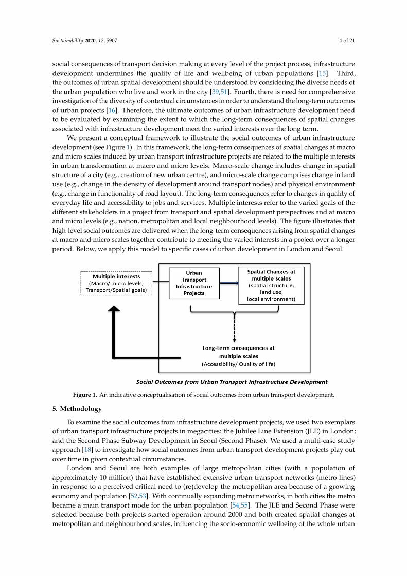
We present a conceptual framework to illustrate the social outcomes of urban infrastructuredevelopment (see Figure 1). In this framework, the long-term consequences of spatial changes at macroand micro scales induced by urban transport infrastructure projects are related to the multiple interestsin urban transformation at macro and micro levels. Macro-scale change includes change in spatialstructure of a city (e.g., creation of new urban centre), and micro-scale change comprises change in landuse (e.g., change in the density of development around transport nodes) and physical environment(e.g., change in functionality of road layout). The long-term consequences refer to changes in quality ofeveryday life and accessibility to jobs and services. Multiple interests refer to the varied goals of thedifferent stakeholders in a project from transport and spatial development perspectives and at macroand micro levels (e.g., nation, metropolitan and local neighbourhood levels). The figure illustrates thathigh-level social outcomes are delivered when the long-term consequences arising from spatial changesat macro and micro scales together contribute to meeting the varied interests in a project over a longerperiod. Below, we apply this model to specific cases of urban development in London and Seoul.
Figure 1. An indicative conceptualisation of social outcomes from urban transport development.
5. Methodology
To examine the social outcomes from infrastructure development projects, we used two exemplarsof urban transport infrastructure projects in megacities: the Jubilee Line Extension (JLE) in London;and the Second Phase Subway Development in Seoul (Second Phase). We used a multi-case studyapproach [18] to investigate how social outcomes from urban transport development projects play outover time in given contextual circumstances.
London and Seoul are both examples of large metropolitan cities (with a population ofapproximately 10 million) that have established extensive urban transport networks (metro lines)in response to a perceived critical need to (re)develop the metropolitan area because of a growingeconomy and population [52,53]. With continually expanding metro networks, in both cities the metrobecame a main transport mode for the urban population [54,55]. The JLE and Second Phase wereselected because both projects started operation around 2000 and both created spatial changes atmetropolitan and neighbourhood scales, influencing the socio-economic wellbeing of the whole urban
Sustainability 2020, 12, 5907 5 of 21
population [52,56–58]. However, these two cities differ in some aspects, such as their pattern and stageof urban development.
As indicated in Figure 1, the mid- to long-term consequences (i.e., approximately 15 years) of thetwo projects were evaluated in relation to spatial changes and the varied interests in the projects atmultiple levels. Given the complexity of evaluating outcomes [59], we used multiple methods in apragmatic and contextualised approach [60] to investigate each exemplar. Our research included ananalysis of primary source documents (e.g., key project documents); secondary sources (e.g., newsreports, journal articles); official data (e.g., census data); in-depth interviews with experts and keystakeholders; semi-structured interviews with residents; and onsite observation.
Using multiple methods, data about interests and outcomes were collected and analysed atmultiple levels and across the different areas (i.e., local neighbourhoods) in each city. To understandthe interests related to the projects, although arguably conceptually different, we used stated projectgoals as a proxy for the interests of certain stakeholders. To understand the outcomes, quantitativeand qualitative measures were used to investigate the multi-scale spatial changes (i.e., change inspatial structure, land use, and physical environment) and long-term consequences (i.e., accessibility toopportunities and quality of life at multiple scales) in line with the conceptual framework in Figure 1.As not all the relevant concepts are readily measurable, some proxy measures were used (see Table 1).
Table 1. Criteria and indicative measures used to examine outcomes from infrastructure development.
ScaleUrban Spatial Changes Long-Term Consequences Associated with Spatial Changes
Construct Example Proxy Measures Construct Example Proxy Measures
Macro Change in spatialstructure of cities
- number, size and type oftransport/regeneration projectsimplemented, and employmentdensity in (newly created)centres (e.g., within 500 mfrom stations)
Accessibility andquality of life atmacro scale
- number and % of populationcommuting over 60 mins
- number and % of population withaccess to subway within 500 m
MicroChange in land useand physicalenvironment
- pattern and density of landdevelopment along corridors(e.g., within 500 m of station)
- quality and quantity of newlycreated and existing publicinfrastructure around nodes
- quality and quantity ofpedestrian access aroundtransport nodes
- functionality of road layout
Accessibility andquality of life atmicro scale
- local safety; range oflocal amenities
- accessibility to jobs and services,and public transport (e.g., no. ofjobs within 30 min journey time;commuting time)
- differential outcomes among localneighbourhoods (e.g., % ofpopulation commuting less than60 min by local district; % of areawithout subway within 500 m bylocal district)
To identify the interests and understand the context of each case, we examined all relevantdocuments, including official project documents, White Papers, territorial policy, transport plans atdifferent scales, strategic urban plans, and local development plans and policies. To understand theoutcomes of each case, we examined impact assessment reports, results of local surveys, historic maps,and empirical studies on the spatial changes and long-term consequences of each project. Officialdata and surveys were also examined, including journey-to-work time, public transport accessibilitydata, and annual business surveys. Income data and the deprivation index across cities providedinformation about differential outcomes between and within neighbourhoods. Various time periodsand scales of data were used to identify the changes taking place in London and Seoul over time andspace. Onsite observation was also undertaken, especially to validate information relating to ease ofaccess, and quality of public space in proximity to nodes.
Some 22 in-depth interviews were conducted in 2018 with a range of key stakeholders (16 inSeoul and 6 in London). They included people working for government or policy institutes (urban andtransport development) at national, metropolitan, or local neighbourhood levels, on matters concerningtransport, territorial (spatial) planning, project development. Interviewees were selected accordingto their role in the planning process (i.e., key decision makers or technical planners in spatial and/or
Sustainability 2020, 12, 5907 6 of 21
transport planning involved in the actual projects). Interviewees were identified through snowballing.Collection of interview data ceased when recurring viewpoints occurred with additional interviewsand saturation was achieved [61]. The interviews were structured along the lines of the conceptualframework (Figure 1), identifying policy goals and key interests in the project at multiple levels,and views on spatial changes and associated long-term consequences. The interviewees were askedwhich interests were prioritized during planning and implementation of the project. Intervieweeswere also asked to give their opinions on the extent to which the project met the various interests andto identify any other factors that affected the project process and outcomes. The interviews were donein a manner consistent with ethical social research [62].
In London, in addition to the in-depth interviews with key stakeholders, 29 semi-structuredinterviews were conducted with Canning Town residents in July 2016. These interviews investigatedthe spatially-differentiated outcomes and interests among the different social groups. Canning Townwas one of the most deprived neighbourhoods along the JLE [63], even though regeneration schemeshad been implemented there since the JLE opened. Questions were structured around three topics:the life pattern of these residents; the positive and negative changes experienced; and the impacts ofthese changes on their quality of life.
The long-term consequences of the projects were evaluated by analysing all data collected.The transcripts of interviews were coded and analysed using ATLAS.ti. The analysis was based aroundthe following specific questions: (1) to what extent did the spatial transformation triggered by theproject bring positive consequences at the local scale as well as the macro scale? (2) to what extentwere the varied interests of the population (at neighbourhood and metropolitan and national levels)addressed in the long term? (3) to what extent were the interests of different parts of the cities (i.e.,centre and periphery, most deprived and least deprived) addressed in a fair manner?
6. Exemplar 1: Jubilee Line Extension in London
6.1. Background
London experienced much urban expansion and transformation in the 20th century [64].This transformation was largely possible because of its network of metropolitan railways, the backboneof which was developed between 1850 and 1930 [32]. London’s expansion was not without somesetbacks. Economic decline following World War II up until the early 1990s led to net out-migration [64].The London Docklands, in east London, was particularly affected by this decline. Traditionally animportant port and warehousing district, containerisation and the shift to large freight ships diminishedits status. With poor land transport links to London central city, the Docklands was effectively cut off
and its local economy floundered, leading to widespread deprivation [57]. In the 1980s, the nationalgovernment, Greater London Council, and five local borough governments in the Docklands put mucheffort into regenerating the area. One important project was the Docklands Light Rail, which wasopened in 1987 to improve access and provide the transport infrastructure necessary to stimulatedevelopment in east London. Economic and population growth across London in the 1990s ledto discussion about the need for new economic centres and to extend and enhance London’s masstransport system.
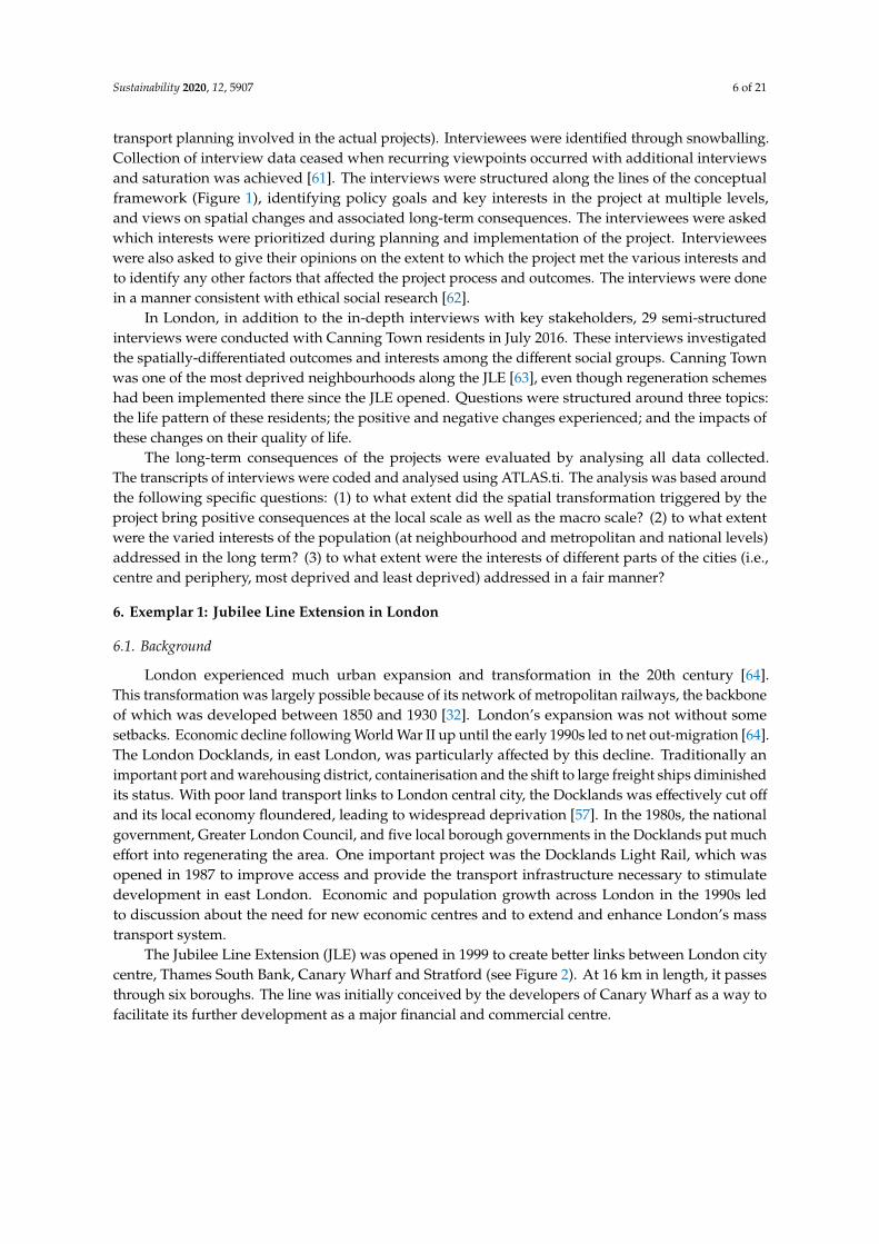
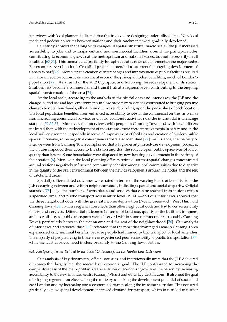
The Jubilee Line Extension (JLE) was opened in 1999 to create better links between London citycentre, Thames South Bank, Canary Wharf and Stratford (see Figure 2). At 16 km in length, it passesthrough six boroughs. The line was initially conceived by the developers of Canary Wharf as a way tofacilitate its further development as a major financial and commercial centre.
Sustainability 2020, 12, 5907 7 of 21
Figure 2. The Jubilee Line Extension in east London (note: the JLE is the dark grey line running fromWestminster to Stratford) (source: adapted from london-tube.com [65]).
6.2. Key Interests Related to the Jubilee Line Extension at Multiple Levels
The analysis of documents and interviews enabled the varying interests in the outcomes of theJLE to be identified, and were affected by level (e.g., national, city, and neighbourhood) and sector (e.g.,transport and urban development). The principal transport planners for the JLE project (whom weinterviewed) emphasised that the main intention of the decision makers at the national level was forthe JLE to contribute to sustaining London’s dominant position as a financial centre by facilitatingthe further development of Canary Wharf. The top priority of central government and the ownerof Canary Wharf was to increase accessibility to Canary Wharf by ensuring there was a direct linkbetween it and the city centre, as well as to the mainline rail terminals (e.g., Waterloo) [66]. As indicatedby our interviews with local planning officers and our document analysis, the key interests at the citylevel were to reduce development pressure in the city centre by encouraging development of housingand office projects in east and south London; and provide better access to the Underground, especiallyfor people who were previously underserviced [52].
At the local level, we identified that the major interests were increased accessibility to variousdestinations and job creation. A transport planner we interviewed indicated that local authoritieshad different levels of interest in the secondary development effects (i.e., housing, office, commercialdevelopment) around the new and redeveloped stations built for the JLE due to the differing prioritiesof the local authorities. Some aspired to have high-density mixed-use development, which wouldflow from the development of stations, while others (e.g., some boroughs in south London, such asSouthwark) were not interested in such development [52,67]. Furthermore, in the interviews withlocal residents in Canning Town, different interests in urban regeneration associated with JLE wereidentified among different groups of people. Some anticipated a better living environment and businessopportunities, while others were concerned that the development opportunities would be inconsistentwith the needs of local people in their neighbourhood. Table 2 presents a summary of the interestsidentified in our study.
Sustainability 2020, 12, 5907 8 of 21
Table 2. Interests related to the outcomes of the Jubilee Line Extension at multiple levels.
Level Interests Related toTransport Development Interests Related to Urban Development
National andregional levels
Increase access to a newly developedeconomic hub from central hubs and
wider areas
Support continuation of investment andeconomic growth by establishing a
financial centre
City levelGive better access to Underground services
for a wider area (i.e., east and southeastLondon), and relieve traffic and congestion
Support development and enhanceregeneration along the routes, and reducedevelopment pressure in the city centre
Neighbourhoodlevel
Increase accessibility to jobs and services inthe centre and local areas (the aspiration
since 1980s)
Job creation and better businessopportunities, provide modern facilities
and housing, and develop public services
6.3. Spatial Changes and Associated Long-Term Consequences at Macro and Micro Scales
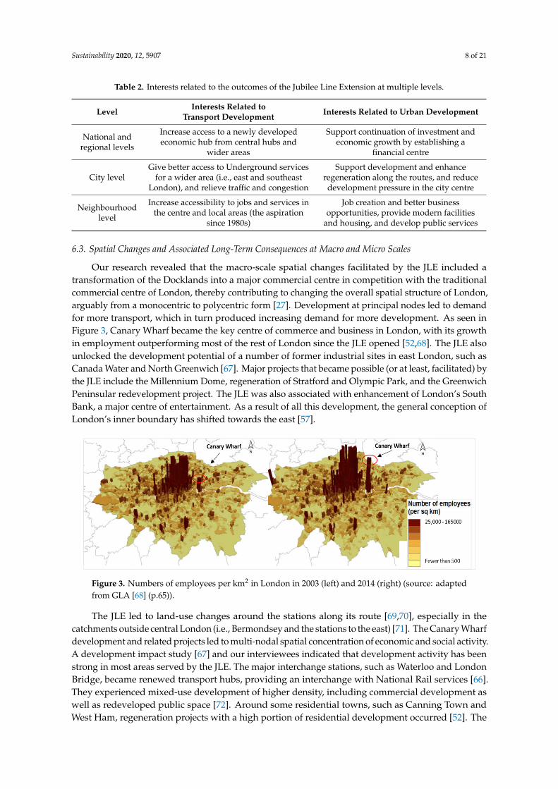
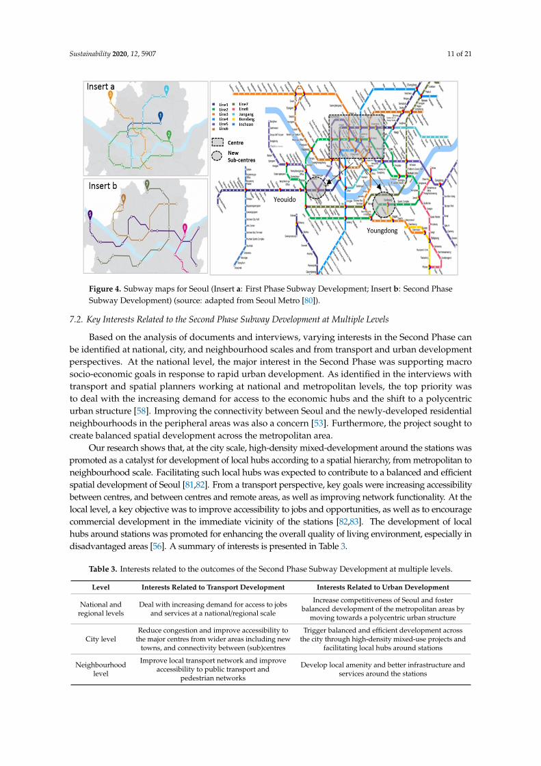
Our research revealed that the macro-scale spatial changes facilitated by the JLE included atransformation of the Docklands into a major commercial centre in competition with the traditionalcommercial centre of London, thereby contributing to changing the overall spatial structure of London,arguably from a monocentric to polycentric form [27]. Development at principal nodes led to demandfor more transport, which in turn produced increasing demand for more development. As seen inFigure 3, Canary Wharf became the key centre of commerce and business in London, with its growthin employment outperforming most of the rest of London since the JLE opened [52,68]. The JLE alsounlocked the development potential of a number of former industrial sites in east London, such asCanada Water and North Greenwich [67]. Major projects that became possible (or at least, facilitated) bythe JLE include the Millennium Dome, regeneration of Stratford and Olympic Park, and the GreenwichPeninsular redevelopment project. The JLE was also associated with enhancement of London’s SouthBank, a major centre of entertainment. As a result of all this development, the general conception ofLondon’s inner boundary has shifted towards the east [57].
Figure 3. Numbers of employees per km2 in London in 2003 (left) and 2014 (right) (source: adaptedfrom GLA [68] (p.65)).
The JLE led to land-use changes around the stations along its route [69,70], especially in thecatchments outside central London (i.e., Bermondsey and the stations to the east) [71]. The Canary Wharfdevelopment and related projects led to multi-nodal spatial concentration of economic and social activity.A development impact study [67] and our interviewees indicated that development activity has beenstrong in most areas served by the JLE. The major interchange stations, such as Waterloo and LondonBridge, became renewed transport hubs, providing an interchange with National Rail services [66].They experienced mixed-use development of higher density, including commercial development aswell as redeveloped public space [72]. Around some residential towns, such as Canning Town andWest Ham, regeneration projects with a high portion of residential development occurred [52]. The
Sustainability 2020, 12, 5907 9 of 21
interviews with local planners indicated that this involved re-designing underutilised sites. New localroads and pedestrian routes between stations and their catchments were gradually developed.
Our study showed that along with changes in spatial structure (macro scale), the JLE increasedaccessibility to jobs and to major cultural and commercial facilities around the principal nodes,contributing to economic growth at the metropolitan and national scales, but not necessarily in alllocalities [67,71]. This increased accessibility brought about further development at the major nodes.For example, even London’s CrossRail project is intended to support the ongoing development ofCanary Wharf [73]. Moreover, the creation of interchanges and improvement of public facilities resultedin a vibrant socio-economic environment around the principal nodes, benefiting much of London’spopulation [72]. As a result of the 2012 Olympics, and following the redevelopment of its station,Stratford has become a commercial and transit hub at a regional level, contributing to the ongoingspatial transformation of the area [74].
At the local scale, according to the analysis of the official data and interviews, the JLE and thechange in land use and local environments in close proximity to stations contributed to bringing positivechanges to neighbourhoods, albeit in unique ways, depending upon the particulars of each location.The local population benefited from enhanced accessibility to jobs in the commercial centres, as well asfrom increasing commercial services and socio-economic activities near the intermodal interchangestations [52,55,72]. Moreover, the interviews with people in Canning Town and with local officersindicated that, with the redevelopment of the stations, there were improvements in safety and in thelocal built environment, especially in terms of improvement of facilities and creation of modern publicspaces. However, some negative consequences were also identified [72], for instance, the majority ofinterviewees from Canning Town complained that a high-density mixed-use development project atthe station impeded their access to the station and that the redeveloped public space was of lowerquality than before. Some households were displaced by new housing developments in the vicinity oftheir station [8]. Moreover, the local planning officers pointed out that spatial changes concentratedaround stations negatively influenced community cohesion among local communities due to disparityin the quality of the built environment between the new developments around the nodes and the restof catchment areas.
Spatially differentiated outcomes were noted in terms of the varying levels of benefits from theJLE occurring between and within neighbourhoods, indicating spatial and social disparity. Officialstatistics [75]—e.g., the numbers of workplaces and services that can be reached from stations withina specified time, and public transport accessibility level (PTAL)—and our interviews showed thatthe three neighbourhoods with the greatest income deprivation (North Greenwich, West Ham andCanning Town) [63] had less regeneration effects than other neighbourhoods and had lower accessibilityto jobs and services. Differential outcomes (in terms of land use, quality of the built environment,and accessibility to public transport) were observed within some catchment areas (notably CanningTown), particularly between the station area and the rest of the neighbourhood [76]. Our analysisof interviews and statistical data [63] indicated that the most disadvantaged areas in Canning Townexperienced only minimal benefits, because people had limited public transport or local amenities.The majority of people living in these areas experienced poor accessibility to public transportation [77],while the least deprived lived in close proximity to the Canning Town station.
6.4. Analysis of Issues Related to the Social Outcomes from the Jubilee Line Extension
Our analysis of key documents, official statistics, and interviews illustrate that the JLE deliveredoutcomes that largely met the macro-level economic goal. The JLE contributed to increasing thecompetitiveness of the metropolitan area as a driver of economic growth of the nation by increasingaccessibility to the new financial centre (Canary Wharf) and other key destinations. It also met the goalof bringing regeneration effects along the route by unlocking the development potential of south andeast London and by increasing socio-economic vibrancy along the transport corridor. This occurredgradually as new spatial development increased demand for transport, which in turn led to further
Sustainability 2020, 12, 5907 10 of 21
development. As such, the JLE met the objectives of enhancing access to the new economic hub andbetter access to the Underground, especially for those living further away.
At the local level, however, it is not clear whether the JLE and the associated spatial changesbrought about net improvement in the quality of life in all local neighbourhoods, or met the variedrespective interests. Our analysis indicated that neighbourhoods in east London (e.g., Canning Town)experienced poor accessibility to opportunities and public transport, because of the local consequencesof the regeneration projects (e.g., poorly integrated designs blocking public passages and poor qualityof the regenerated public space adjacent to nodes). The regeneration projects hardly addressed theinterests of some neighbourhoods for improved social infrastructure, as they mainly resulted inhigh-density mixed-use development. Moreover, our research identified that local neighbourhoodsbenefited from reduced journey time once the project opened. However, there was spatial and socialdifferentiation in the benefits over time. This study showed that the differential levels of accessibility toinfrastructure were exacerbated by regeneration projects targeted only to specific locations (e.g., areasadjacent to transport nodes), and by the loss of local amenities in locations at the edge of catchmentareas. Such consequences are related to multiple negative impacts on accessibility for people livingin the most deprived areas within neighbourhoods, negatively influencing social cohesion. Overall,it is questionable whether the JLE brought about positive net change in the wellbeing of all localcommunities over time, or in meeting the interests of all stakeholders in a balanced manner.
As confirmed by the interviews with principal transport planners at national and metropolitanlevels, key decision makers were mainly concerned about the cost efficiency of development andquickly increasing connectivity to Canary Wharf and between the principal nodes. The centralgovernment took control of local planning, and the differing priorities and concerns of the variousboroughs were not taken into consideration, even though some local authorities including those insouth London expressed concerns about the negative consequences their neighbourhoods wouldexperience. In practice, the primary concern of the planners was to enhance the mobility of the urbanpopulation rather than to increase overall accessibility to opportunities and connectivity to stations.Interestingly, the planner at one local borough suggested that the key objective of the regenerationprojects was not increasing overall social wellbeing, but increasing density through more privateresidential housing.
7. Exemplar 2: The Second Phase Subway Development in Seoul
7.1. Background
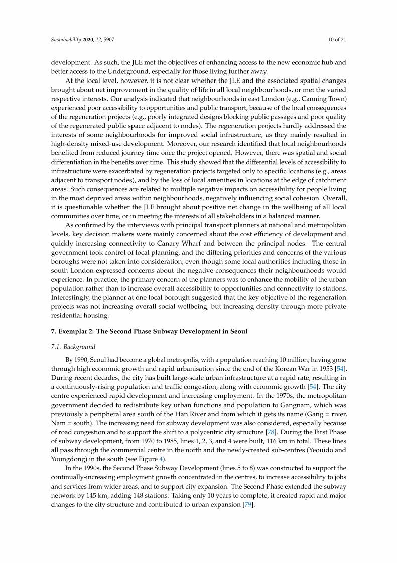
By 1990, Seoul had become a global metropolis, with a population reaching 10 million, having gonethrough high economic growth and rapid urbanisation since the end of the Korean War in 1953 [54].During recent decades, the city has built large-scale urban infrastructure at a rapid rate, resulting ina continuously-rising population and traffic congestion, along with economic growth [54]. The citycentre experienced rapid development and increasing employment. In the 1970s, the metropolitangovernment decided to redistribute key urban functions and population to Gangnam, which waspreviously a peripheral area south of the Han River and from which it gets its name (Gang = river,Nam = south). The increasing need for subway development was also considered, especially becauseof road congestion and to support the shift to a polycentric city structure [78]. During the First Phaseof subway development, from 1970 to 1985, lines 1, 2, 3, and 4 were built, 116 km in total. These linesall pass through the commercial centre in the north and the newly-created sub-centres (Yeouido andYoungdong) in the south (see Figure 4).
In the 1990s, the Second Phase Subway Development (lines 5 to 8) was constructed to support thecontinually-increasing employment growth concentrated in the centres, to increase accessibility to jobsand services from wider areas, and to support city expansion. The Second Phase extended the subwaynetwork by 145 km, adding 148 stations. Taking only 10 years to complete, it created rapid and majorchanges to the city structure and contributed to urban expansion [79].
Sustainability 2020, 12, 5907 11 of 21
Figure 4. Subway maps for Seoul (Insert a: First Phase Subway Development; Insert b: Second PhaseSubway Development) (source: adapted from Seoul Metro [80]).
7.2. Key Interests Related to the Second Phase Subway Development at Multiple Levels
Based on the analysis of documents and interviews, varying interests in the Second Phase canbe identified at national, city, and neighbourhood scales and from transport and urban developmentperspectives. At the national level, the major interest in the Second Phase was supporting macrosocio-economic goals in response to rapid urban development. As identified in the interviews withtransport and spatial planners working at national and metropolitan levels, the top priority wasto deal with the increasing demand for access to the economic hubs and the shift to a polycentricurban structure [58]. Improving the connectivity between Seoul and the newly-developed residentialneighbourhoods in the peripheral areas was also a concern [53]. Furthermore, the project sought tocreate balanced spatial development across the metropolitan area.
Our research shows that, at the city scale, high-density mixed-development around the stations waspromoted as a catalyst for development of local hubs according to a spatial hierarchy, from metropolitan toneighbourhood scale. Facilitating such local hubs was expected to contribute to a balanced and efficientspatial development of Seoul [81,82]. From a transport perspective, key goals were increasing accessibilitybetween centres, and between centres and remote areas, as well as improving network functionality. At thelocal level, a key objective was to improve accessibility to jobs and opportunities, as well as to encouragecommercial development in the immediate vicinity of the stations [82,83]. The development of localhubs around stations was promoted for enhancing the overall quality of living environment, especially indisadvantaged areas [56]. A summary of interests is presented in Table 3.
Table 3. Interests related to the outcomes of the Second Phase Subway Development at multiple levels.
Level Interests Related to Transport Development Interests Related to Urban Development
National andregional levels
Deal with increasing demand for access to jobsand services at a national/regional scale
Increase competitiveness of Seoul and fosterbalanced development of the metropolitan areas by
moving towards a polycentric urban structure
City levelReduce congestion and improve accessibility to
the major centres from wider areas including newtowns, and connectivity between (sub)centres
Trigger balanced and efficient development acrossthe city through high-density mixed-use projects and
facilitating local hubs around stations
Neighbourhoodlevel
Improve local transport network and improveaccessibility to public transport and
pedestrian networks
Develop local amenity and better infrastructure andservices around the stations
Sustainability 2020, 12, 5907 12 of 21
7.3. Spatial Changes and Associated Long-Term Consequences at Macro and Micro Scales
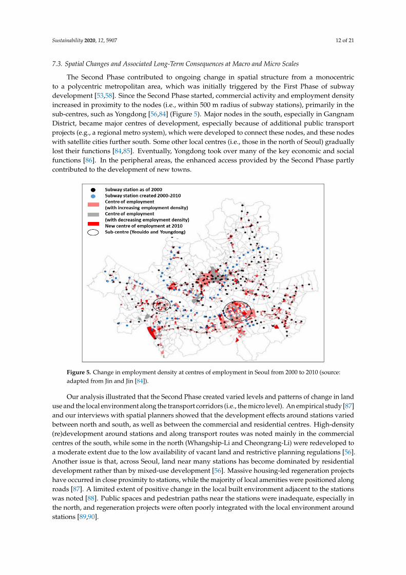
The Second Phase contributed to ongoing change in spatial structure from a monocentricto a polycentric metropolitan area, which was initially triggered by the First Phase of subwaydevelopment [53,58]. Since the Second Phase started, commercial activity and employment densityincreased in proximity to the nodes (i.e., within 500 m radius of subway stations), primarily in thesub-centres, such as Yongdong [56,84] (Figure 5). Major nodes in the south, especially in GangnamDistrict, became major centres of development, especially because of additional public transportprojects (e.g., a regional metro system), which were developed to connect these nodes, and these nodeswith satellite cities further south. Some other local centres (i.e., those in the north of Seoul) graduallylost their functions [84,85]. Eventually, Yongdong took over many of the key economic and socialfunctions [86]. In the peripheral areas, the enhanced access provided by the Second Phase partlycontributed to the development of new towns.
Figure 5. Change in employment density at centres of employment in Seoul from 2000 to 2010 (source:adapted from Jin and Jin [84]).
Our analysis illustrated that the Second Phase created varied levels and patterns of change in landuse and the local environment along the transport corridors (i.e., the micro level). An empirical study [87]and our interviews with spatial planners showed that the development effects around stations variedbetween north and south, as well as between the commercial and residential centres. High-density(re)development around stations and along transport routes was noted mainly in the commercialcentres of the south, while some in the north (Whangship-Li and Cheongrang-Li) were redeveloped toa moderate extent due to the low availability of vacant land and restrictive planning regulations [56].Another issue is that, across Seoul, land near many stations has become dominated by residentialdevelopment rather than by mixed-use development [56]. Massive housing-led regeneration projectshave occurred in close proximity to stations, while the majority of local amenities were positioned alongroads [87]. A limited extent of positive change in the local built environment adjacent to the stationswas noted [88]. Public spaces and pedestrian paths near the stations were inadequate, especially inthe north, and regeneration projects were often poorly integrated with the local environment aroundstations [89,90].
Sustainability 2020, 12, 5907 13 of 21
According to our analysis of documents and our interviews, the changes in the spatial structure ofSeoul associated with the Second Phase contributed to the socio-economic development of the cityat the macro scale. The centres of commerce and employment in Seoul, which were well connectedto each other as well as to their wider areas, had a continuously-increasing role as a socio-economichub. However, it was difficult to confirm whether the subway development actually increased accessto opportunities for the whole urban society. Our research identified a growing percentage of thepopulation who commuted by subway more than one hour [91–93]. Moreover, various studies [84,85]have indicated that different levels of job accessibility were observed in different parts of the city.Districts in the south (e.g., Gangnam District and Seocho District) have the highest level of jobaccessibility with the highest rates of increase, while north and east Seoul did not see much changesince 2000.
Interviews with transport planners and a few studies on accessibility to public transport (e.g.,9589,90]) indicated that there were limited consequences on quality of life at the local level, especiallyin local residential areas, due to the moderate level of station area development and poor connectivitybetween stations and the rest of the neighbourhoods (see also [56]). Station areas appeared to haveplayed only a limited role as a socio-economic hub, given the dominance of residential projects as wellas many of the local amenities located along roads [87,88]. Much of the population (except for thoseliving in the sub-centres in the south) needed to travel to access services [94]. Some negative impacts ofthe housing-led regeneration projects were noted within the neighbourhood areas. Large-scale housingdevelopments adjacent to stations often restricted mobility within the neighbourhoods, affecting thefunctionality of pedestrian pathways, and contributed to the loss of local identity [89,95]. We alsoidentified that some local communities were displaced to make way for new housing developments inthe vicinity of stations, although many of these developments were already planned, and were notstrictly due to the subway expansion.
Our analysis revealed that there were spatially differential outcomes (e.g., accessibility to jobsand public transport) across the urban area, especially between the least and most deprived areas.In the districts with highest income (of households) [96,97], such as Gangnam, approximately 70%of residents commuted to work within one hour, while less than half of the residents in the areas oflowest income (e.g., Gangbuk District) could travel to work within one hour [92,93]. Such a differencewas also seen with accessibility to public transport; the areas of highest income had much greateraccessibility to public transport than the poorest areas. Almost half of Gangnam District had subwaystations within a short walking distance (i.e., within 500 m), while Gangbuk in the north has highestproportion of areas without a subway station within 500 m [98,99].
7.4. Analysis of Issues Related to Social Outcomes from the Second Phase Subway Development
Our study suggests that the Second Phase appeared to contribute to achieving the macro scaleeconomic goals of the city. Within a short time period, the project increased connectivity to the majornodes from wider areas. However, it is not clear whether the Second Phase contributed to facilitatingbalanced development across the whole metropolitan area, even though this was a stated goal. In thecentres, especially in the south, the positive impacts increased due to the iterative effect betweendevelopment and the provision of transport infrastructure, while the peripheral areas experiencedonly limited positive impacts. The sub-centres in the south have seen an increasing concentration ofjobs, while other sub-centres and local centres only had a limited amount of change around the nodes,especially in the peripheral areas. As a result, more people have to commute a longer time, especiallythose living in peripheral areas although subway lines have served a wider population.
The extent to which the respective interests at the local level were met by the outcomes of theSecond Phase was less clear due to the limited level of spatial change around stations and the differentiallevel of increase in accessibility between the centres and the rest of the city. Despite strong interest inspatial development around the stations, the subway development facilitated only a limited amountof high-density commercial development, especially in local centres in the peripheral areas, and the
Sustainability 2020, 12, 5907 14 of 21
station areas only played a limited role as a local hub. The positive consequences on quality of dailylife in local neighbourhoods were limited due to the inadequacy of the pedestrian pathways thatconnected to the stations, as well as the poor connectivity between subways and neighbourhoods,especially in the peripheral areas. Our research identified that the long-term spatial changes wereclosely related to multiple negative impacts on people living in low-income districts in the peripheralareas. They travelled further to access jobs and services, and were influenced by a lower quality of theliving environment around the transport nodes. Overall, it is not clear whether the Second Phase hascontributed to enhancing accessibility to opportunities for the whole urban population, or meeting thestrong interests in obviating socio-economic disparity across the city.
Interviews with a principal transport planner and a project manager suggested that, becauseof the rapidly growing economy and population, the central government only focused on achievingimmediate outcomes. Cost efficiency and increasing connectivity between principal nodes, and betweenthe nodes and the new residential developments, were the main issues that were considered. Interviewswith spatial planners indicated that developing station areas as a catalyst for the development of localhubs was little considered or discussed in the project planning process, despite being a stated goal ofthe official spatial plan [80,81]. Planners only considered station area development to a limited extent,and rarely took connectivity to public transport or the lack of pedestrian paths into consideration.Furthermore, meeting the differential needs of the different parts of the city (e.g., centres and peripheralareas) was hardly discussed, even though facilitating balanced development was a key policy goal.
8. Discussion on Social Outcomes from Urban Transport Development
The two exemplars of London and Seoul have illustrated that social outcomes from urbaninfrastructure development are produced in a complex manner, and are influenced by spatial changesand varied contexts. Our study showed that evaluating social outcomes from transport projectsrequires careful consideration of the consequences of multi-scale spatial changes over time, as wellas of the varied interests in the project in the specific context of the city in question. In this section,we discuss the importance of understanding the interaction between transport and spatial developmentat macro and micro scales. We also discuss our insights related to how the social outcomes could beenhanced to better address the varied interests in urban transport development.
8.1. Multi-Scale Spatial Development and Long-Term Consequences of Transport Development
The two exemplars demonstrate the importance of understanding how spatial changes induced byurban transport infrastructure development at various scales influence the ultimate benefits for societythat arise from such development. Our study revealed that benefits such as enhanced accessibility canbe undermined by incremental spatial changes. In the case of the London, the JLE contributed to thesuccess of a new economic centre (Canary Wharf) and to facilitating regeneration around the nodes,which resulted in enhanced accessibility to opportunities for many members of society. However,various negative consequences from spatial changes that were triggered by the regeneration projectsdetracted from the benefits of accessibility gains and enhanced living environments around stations.In the Seoul subway case, despite increased mobility at the macro level, the positive changes to qualityof life were limited because of the low level of spatial change at many nodes (except for the commercialcentres), and poor accessibility to jobs and services (concentrated in commercial centres) for most ofthe urban population.
Our study also indicated that expansion of transport networks does not guarantee increasedaccess to opportunities for all because of the differential patterns and scales of the spatial changesoccurring across cities. Both in Seoul and London, differential outcomes across urban areas can beattributed to the varied pace and scope of spatial development occurring over time in the differentlocations across each city, and among different social groups. In Seoul, the high-income districts inthe commercial centre of the south benefited from enhanced accessibility that arose from increasingjob density and improved transport networks. However, people in most other districts, especially
Sustainability 2020, 12, 5907 15 of 21
those in the low-income peripheral areas, received only limited benefits and experienced multiplenegative impacts, due to longer travelling time to jobs (which were being concentrated in the centres),limited development of local amenities, and little improvement in the built environment. In London,our study identified differential levels of benefits within and between neighbourhoods, and amongdifferent social groups. Such differences were closely related to the varied scales of the regenerationprojects, as well as to varying accessibility to opportunities between the centre and peripheral areas,and between least and most deprived areas. Both cases also indicated that the long-term spatialchanges created negative influences on social cohesion among local populations at city and local levels.
These results suggest that evaluating social outcomes requires investigating the interactionbetween transport and spatial development at macro and micro scales over time, and reflecting onhow the consequences of such multi-scale interactions affect accessibility and the quality of life oflocal neighbourhoods across a city. Our research illustrated that the spatial changes occurring aroundtransport nodes were incremental, and that the societal consequences of this cannot be fully foreseenwhen infrastructure development planning takes place. Therefore, to enhance the achievement ofpositive long-term social change in the future, rather than primarily focusing on enhancing ex-anteevaluation (see [100]), what is perhaps more needed is improving ex post evaluation, especially inrelation to examining what actually happens from the spatial changes created. Such ex post evaluationneeds to consider changes in the patterns and scale of land use around nodes, changes in the level ofintegration between stations and (re)developed local environments, changes in connectivity of the localroad network, as well as connectivity to major destinations. Moreover, our study indicates that thereneeds to be explicit attention to the cumulative effects from the multi-scale spatial changes for specificpopulations and areas, especially those who experience multiple negative impacts [8]. Urban transportprojects alone will not always bring about positive changes to the wellbeing of the whole society,nor facilitate a fair distribution of benefits across society [9,14,101]. The consequences of unbalancedspatial development across cities on the most and least deprived groups need to be evaluated andmonitored to ensure that urban transport development bring desired outcomes across varied localitiesand social groups.
8.2. Social Outcomes within Specific Contexts
Our study illustrated that the social outcomes from urban infrastructure projects were relatedto the specific context of each case, such as the pattern and stage of urban spatial development andbroader socio-economic contexts. These factors varied between Seoul and London, which createddifferent issues that had to be addressed. In Seoul, the Second Phase resulted in only a limited levelof spatial development around nodes and a limited role of the station areas as local hubs. Manyinterviewees emphasised that the linear pattern of urban development along roads resulted from thecar-oriented, rapid urban development of Seoul, as well as from the restrictive planning regulationson land development at transport nodes. Conversely, in London, the JLE facilitated refurbishment ofstation areas and regeneration of the vicinity of stations, due to the rail-oriented urban (re)development(i.e., spatial development concentrated around nodes), as well as the availability of developable landaround station areas.
These differences between the two exemplars imply that each case had different issues to dealwith. In London, priority needed to be given to mitigating the various negative social consequences ofthe long-term spatial changes triggered by the (re)development of station areas. In Seoul, the key issueto enhance social outcomes appeared to be dealing with the increased commuting time for many localresidents. Explicit attention is needed to consider how to trigger the appropriate spatial developmentat nodes in the peripheral areas of the city. Overall, our research clearly shows that an approachto enhance social outcomes should carefully address the huge diversity of local contexts that affectlong-term consequences, and that such approach should be moving beyond panacea thinking [16].
Sustainability 2020, 12, 5907 16 of 21
8.3. Implications for an Integrated Approach to Enhance Social Outcomes of Urban Infrastructure
Our research suggests that discrepancies between transport planning and spatial developmentplanning (see [47]) might result in limited benefits from urban infrastructure projects for society. Thesediscrepancies may lead to a failure to deal with the long-term societal consequences arising fromthe multi-scale spatial changes. Our study indicates that, to ultimately enhance social outcomes,an integrated approach to transport and spatial development is needed [12,46], and that it shouldgive attention to the scale and time dimensions of the spatial changes triggered by urban transportdevelopment projects.
The study findings suggest that a multi-level integrated approach needs to facilitate planningand evaluation of social outcomes, focusing on the long-term consequences of spatial changes on thequality of life of urban populations. A macro-level urban policy needs to address a broader range ofgoals of urban transport projects, as well as the social consequences that arise from unbalanced spatialdevelopment across cities. Such a policy needs to consider integration of spatial development andtransport development at strategic locations (e.g., commercial centres in sub-centre and periphery),especially those with potential to become regional transit hubs. At the micro level, an area-basedapproach to planning and evaluation of projects, e.g., integrating infrastructure development intoadjacent land uses and assessing the consequences of spatial changes on local environments, shouldbe considered. In addition, there needs to be a tailor-made approach to integrated planning andevaluation that carefully addresses the interests and priorities of the local population in specific contexts,according to location (e.g., city centre, local centre, and regional centre), function (e.g., commercial andresidential areas), socio-economic conditions (e.g., high-income and low-income areas), and the overalldevelopment stage of the city (e.g., rapidly expanding or renewing existing cities).
9. Conclusions
By examining urban transport development projects in megacities, London and Seoul, this paperinvestigated how the social outcomes from such projects play out by reflecting on the long-term spatialchanges and on the varied interests in the outcomes of the projects at multiple levels. Our researchclearly shows the need for an integrated and broader approach to urban transport infrastructuredevelopment that addresses social consequences of multi-scale spatial changes induced by projects,including those that are unexpected or unintended. Our research indicated that the expansion ofurban transport networks by itself does not guarantee increased accessibility or quality of life for thewhole of the society, due to the differential pace and scope of the spatial changes that occur across acity, as well as the unexpected or unintended negative impacts of spatial transformation at the localneighbourhood scale. The two case studies (London and Seoul) revealed that interactions betweentransport development and spatial development at multiple scales will cause unbalanced developmentacross a city (e.g., concentrated commercial development in city centres) and negative consequences forneighbourhoods (e.g., physical severance and disparity around nodes). Such multi-scale consequencesresult in limited social outcomes from urban transport development—specifically, uneven distributionof accessibility and quality of life across local areas and groups.
We have established that the social outcomes are closely related to each specific context, such asthe patterns of urban spatial development in a city. We argue that there is a need for a context-specificapproach to evaluate outcomes and for adaptive management. In a city like London, which experiencedspatial development occurring around the main nodes over a long period of time, attention needs tobe given to the increasingly differentiated outcomes between nodes and the rest of their catchmentareas. In rapidly growing cities, such as Seoul, which experienced high agglomeration effects in theCBD, priorities for enhancing social outcomes should be: dealing with the limited spatial developmentaround nodes in the peripheries; and reducing the disparity between the centre(s) and peripheries.
To ensure sustainable and equitable outcomes from urban transport projects, our research suggeststhat an integrated approach to transport and spatial development at multiple levels is essential.In developing a macro-level strategy for transport network development, urban policy makers and

Sustainability 2020, 12, 5907 17 of 21
transport planners should consider a broader range of goals of urban transport projects, especiallybalanced development across the metropolitan area. At the local level, there needs to be an area-basedapproach to the planning (e.g., integrating infrastructure into land use) and to the evaluation ofprojects (e.g., ex post evaluation of the social impacts of spatial changes, including changes in localenvironmental quality and the functionality of local road networks). Such an integrated approachshould carefully address the varying priorities of the various localities (e.g., city centre or local centre;commercial or residential areas) with their different socio-economic conditions. Overall, enhancingsocial outcomes requires careful consideration of the diversity of contextual circumstances that affectsspatial changes and thus long-term consequences.
We recommend that to understand and enhance social outcomes at all scales, further examinationof the contextual and institutional factors that affect the planning process and delivery of urbaninfrastructure development projects is required. For social outcomes to be the overarching objectiveof development projects, urban transport planning needs to be supported, not only by an integratedapproach to transport and land-use planning, but also by appropriate institutional arrangementsto support the delivery of integrated outcomes. Further research is needed to explore how specificinstitutional conditions (e.g., formal and informal rules) influence the way interests are identified andmanaged at multiple levels, so that, overall, social outcomes will be enhanced. Research about howplanning rules might lead to different outcomes in different contexts will contribute to understandingthe interrelations between local socio-economic conditions and resultant social outcomes. Moreover,by examining local stakeholder perspectives, in-depth investigation of the social consequences ofspatial changes at varied localities will be of great value. Such research will enhance understandingof the social outcomes in different local contexts, such as those with varying levels of densification,gentrification, pedestrian traffic, and the socio-economic conditions of the neighbourhood.
Author Contributions: J.L.: content planning, literature search and review, data collection, data analysis,manuscript writing, and revising; J.A.: content planning and manuscript revising; F.V.: content planning andmanuscript revising; J.W.: content planning and manuscript revising. All authors have read and agreed to thepublished version of the manuscript.
Funding: This research and APC has been funded by University of Groningen.
Acknowledgments: The authors would like to thank the various key informants and local residents whocontributed their comments about the urban transport projects and their neighbourhoods. This work has beenfinancially supported by University of Groningen.
Conflicts of Interest: There is no conflict of interest to declare.
References
1. ADB. Sustainable Urban Transport in Asia: Making the Vision a Reality Asian Development Bank: Manila,Philippines. 2006. Available online: https://www.adb.org/publications/sustainable-urban-transport-asia-makingvision-reality (accessed on 3 May 2018).
2. Dimitriou, H.; Ward, J.; Wright, P. Lessons for Mega Transport Project Developments and the Future of UKCities and Regions 2015. Available online: https://assets.publishing.service.gov.uk/government/uploads/system/uploads/attachment_data/file/499051/future-of-cities-mega-transport-projects.pdf (accessed on 18February 2018).
3. ADBI. Infrastructure for Asian Connectivity; Asia Development Bank Institute: Manila, Philippines, 2017.4. Beyazit, E. Evaluating social justice in transport: Lessons to be learned from the capability approach. Transp.
Rev. 2010, 31, 117–134. [CrossRef]5. Geurs, T.; Boon, W.; van Wee, B. Social impacts of transport: Literature review and the state of the practice of
transport appraisal in the Netherlands and the United Kingdom. Trans. Rev. 2009, 29, 69–90. [CrossRef]6. Stolp, A.; Groen, W.; van Vliet, J.; Vanclay, F. Citizen values assessment: Incorporating citizens’ value
judgements in environmental impact assessment. Impact Assess. Proj. Apprais. 2002, 20, 11–23. [CrossRef]7. Rodrigue, J. The Geography of Transport Systems; Routledge: New York, NY, USA, 2017.
Sustainability 2020, 12, 5907 18 of 21
8. Lee, J. Spatial ethics as an evaluation tool for the long-term impacts of mega urban projects: An applicationof spatial ethics multi-criteria assessment to Canning Town regeneration projects. Int. J. Sustain. Dev. Plan.2018, 13, 541–555. [CrossRef]
9. Levinson, D. Identifying winners and losers in transportation. Transp. Res. Rec. J. Transp. Res. Board. 2002,1812, 179–185. [CrossRef]
10. Brenner, N. The urban question: Reflections on Henri Lefebvre, urban theory and the politics of scale. Int. J.Urban Reg. Res. 2000, 24, 361–378. [CrossRef]
11. Graham, S.; Marvin, S. Splintering Urbanism: Networked Infrastructures, Technological Motilities and the UrbanCondition; Routledge: London, UK, 2001.
12. Bertolini, L. Integrating mobility and urban development agendas: A manifesto. Disp Plan. Rev. 2012, 48,16–26. [CrossRef]
13. Wegener, M.; Fürst, F. Land-Use Transport Interaction: State of the Art; IRPUD: Dortmund, Germany, 1999.14. Martens, K. Justice in transport as justice in accessibility: Applying Walzer’s ‘Spheres of Justice’ to the
transport sector. Transportation 2012, 39, 1035–1053. [CrossRef]15. Jones, P.; Lucas, K. The social consequences of transport decision-making: Clarifying concepts, synthesising
knowledge and assessing implications. J. Trans. Geogr. 2012, 21, 4–16. [CrossRef]16. Healey, P. Collaborative planning in perspective. Plan. Theory 2003, 2, 101–123. [CrossRef]17. Switzer, A.; Bertolini, L.; Grin, J. Transitions of mobility systems in urban regions: A heuristic framework.
J. Envion. Policy Plan. 2013, 15, 141–160. [CrossRef]18. Flyvbjerg, B. Case Study. In The Sage Handbook of Qualitative Research, 4th ed.; Denzien, N., Lincoln, Y., Eds.;
Sage: Thousand Oaks, CA, USA, 2011; pp. 301–316.19. IUS. Global Power City Index 2018; The Mori Memorial Foundation: Tokyo, Japan, 2018.20. UN-HABITAT. Planning Sustainable Cities: Global Report on Human Settlements; UN-HABITAT: Nairobi, Kenya,
2009.21. Bhatta, B. Analysis of Urban Growth and Sprawl from Remote Sensing Data; Springer: Berlin, Germany, 2010.22. Castells, M. The Rise of Network Society; Wiley: Hoboken, NJ, USA, 2010.23. Pflieger, G.; Rozenblat, C. Urban networks and network theory: The city as the connector of multiple
networks. Urban Stud. 2010, 47, 2723–2735. [CrossRef]24. Zanon, B. Infrastructure network development, re-territorialisation process and multilevel territorial
governance: A case study in northern Italy. Plan. Pract. Res. 2011, 26, 325–347. [CrossRef]25. Geurs, T.; van Wee, B. Accessibility evaluation of land-use and transport strategies: Review and research
directions. J. Trans. Geogr. 2004, 12, 127–140. [CrossRef]26. Vecchio, G.; Porreca, R.; Rivera, D. Socio-spatial concerns in urban mobility planning: Insights from
competing policies in Quito. Sustainability 2020, 12, 2923. [CrossRef]27. Hall, P.; Pain, K. The Polycentric Metropolis; Earthscan: London, UK, 2006.28. Bertolini, L.; Curtis, C.; Renne, J. Station area projects in Europe and beyond: Towards transit-oriented
development? Built Envion. 2012, 38, 31–50. [CrossRef]29. Gospodini, A. Urban development, redevelopment and regeneration encouraged by transport infrastructure
projects: The case study of 12 European cities. Eur. Plan. Stud. 2005, 13, 108–111. [CrossRef]30. Vanclay, F. Conceptualising social impacts. Envion. Impact Assess. Rev. 2002, 22, 183–211. [CrossRef]31. Cervero, R. Transport infrastructure and global competitiveness: Balancing mobility and livability. Ann. Am.
Acad. Political Soc. Sci. 2009, 626, 210–225. [CrossRef]32. Hall, P. Cities of Tomorrow: An Intellectual History of Urban Planning and Design in the Twentieth Century;
Blackwell: Oxford, UK, 2002.33. Pereira, R.; Schwanen, T.; Banister, D. Distributive justice and equity in transportation. Transp. Rev. 2017, 37,
170–191. [CrossRef]34. Lucas, K.; van Wee, B.; Maat, K. A method to evaluate equitable accessibility: Combining ethical theory and
accessibility-based approaches. Transportation 2016, 43, 473–490. [CrossRef]35. Revington, N. Gentrification, transit and land use: Moving beyond neoclassical theory. Geogr. Compass 2015,
9, 152–163. [CrossRef]36. Ong, P.; Miller, D. Accessible Cities and Regions: A Framework for Sustainable Transport and Urbanism in the 21st
Century; UC Berkely Centre for Future Urban Transport: Berkely, CA, USA, 2005.37. Hall, P. Great Planning Disasters; Penguin: Berkeley, CA, USA, 1980.
Sustainability 2020, 12, 5907 19 of 21
38. Marsden, G.; May, D. Do institutional arrangement make a difference to transport policy and implementation?Lesson for Britain. Envion. Plan. C Gov. Policy. 2006, 24, 771–789. [CrossRef]
39. Healey, P. In search of the ‘strategic’ in spatial strategy making. Plan. Theory Pract. 2009, 10, 439–457.[CrossRef]
40. Heeres, N.; Tillema, T.; Arts, J. Integration in Dutch planning of motorways: From ‘line’ towards ‘area-oriented’approaches. Transp. Policy 2012, 24, 148–158. [CrossRef]
41. Giddens, A. Time, space and regionalization. In Social Relations and Spatial Structures; Gregory, D., Urry, J., Eds.;Macmillan: London, UK, 1985; pp. 265–295.
42. Madanipour, A. Design of Urban Space: An Inquiry into a Social-Spatial Process; Wiley: Chichester, UK, 1996.43. Priemus, H.; Flyvbjerg, B.; van Wee, B. Decision-Making on Mega-Projects: Cost-Benefit Analysis, Planning and
Innovation; Edward Elgar Publishing: Cheltenham, UK, 2008.44. Baker, M.; Hinks., S. Infrastructure delivery and spatial planning: The case of English local development
frameworks. Town Plan. Rev. 2009, 80, 173–199. [CrossRef]45. Fainstein, S. Mega-projects in New York, London and Amsterdam. Int. J. Urban Reg. Res. 2008, 32, 768–785.
[CrossRef]46. Straatemeier, T.; Bertolini, L. Joint accessibility design: Framework developed with practitioners to integrate
land use and transport planning in the Netherlands. J. Transp. Res. Board. 2008, 77, 1–8. [CrossRef]47. Legacy, C.; Curtis, C.; Sturup, S. Is there a good governance model for the delivery of contemporary transport
policy and practice? An examination of Melbourne and Perth. Transp. Policy. 2012, 19, 8–16. [CrossRef]48. Te Brommelstroet, M.; Bertolini, L. Integrating land use and transport knowledge in strategy-making.
Transportation 2010, 37, 85–104. [CrossRef]49. Miller, D.; Patassini, D. Beyond Benefit Cost Analysis: Accounting for Non-Market Values in Planning Evaluation;
Ashgate: Aldershot, UK, 2005.50. Rydin, Y. Governing for Sustainable Urban Development; Earthscan: London, UK, 2010.51. Hoekveld, G.; Needham, B. Planning practice between ethics and the power games: Making and applying
an ethical code for planning agencies. Int. J. Urban Reg. Res. 2013, 37, 1638–1653. [CrossRef]52. OMEGA Centre. Project Profile UK Jubilee Line Extension; OMEGA Centre: London, UK, 2011.53. SMG. 30 Year History of Subway Development of Seoul; Seoul Metropolitan Government: Seoul, Korea, 2003.54. SMG. Sync Seoul; Seoul Metropolitan Government: Seoul, Korea, 2015.55. TfL. Travel in London; Report 6. 2013. Available online: http://content.tfl.gov.uk/travel-in-london-report-6.
pdf (accessed on 1 November 2018).56. Choi, J.; Gu, J.; Lee, S.; Kim, T.; Seung, H. History, current issues, and perspectives of station area development
of Seoul. J. Korea Plan. Assoc. 2012, 376, 3–19.57. Hall, P.; Hickman, R. Moving the city East: Explorations into contextual public transport-orientated. Dev. Plan.
Pract. Res. 2008, 23, 323–339.58. Kim, K.; Suh, Y. The impacts of city comprehensive plans on the urban spatial structure of Seoul since 1960s:
Focused on the implementation of ‘the Multi-Centric City Concept’. J. Urban Des. Ins. Korea Urban Des. 2016,17, 5–23.
59. Vanclay, F. The potential application of qualitative evaluation methods in European regional development:Reflections on the use of Performance Story Reporting in Australian natural resource management.Reg. Studies. 2015, 49, 1326–1339. [CrossRef]
60. Hoch, C. Evaluating plans pragmatically. Plan. Theory 2002, 1, 53–75. [CrossRef]61. Hennink, M.; Hutter, I.; Bailey, A. Qualitative Research Methods; Sage: London, UK, 2010.62. Vanclay, F.; Baines, J.; Taylor, C.N. Principles for ethical research involving humans: Ethical professional
practice in impact assessment Part I. Impact Assess. Proj. Apprais. 2013, 31, 243–253. [CrossRef]63. ONS. Indices of Deprivation in 2015. Available online: http://dclgapps.communities.gov.uk/imd/idmap.html
(accessed on 1 December 2018).64. Hamnett, C. Unequal City: London in the Global Arena; Routledge: London, UK, 2004.65. London-tube.com. London Tubemap—A new angle on the London Underground. Available online:
http://www.london-tubemap.com/ (accessed on 4 December 2018).66. Willis, J. Extending the Jubilee Line: The Planning Story; London Transport: London, UK, 1997.67. Pharoah, T. Jubilee Line Extension Development Impact Study; University of Westminster: London, UK, 2003.
Sustainability 2020, 12, 5907 20 of 21
68. GLA. Economic Evidence Base for London 2016. Available online: https://www.london.gov.uk/what-we-do/research-and-analysis/economic-analysis/economic-evidence-base-london-2016 (accessed on 30November 2018).
69. MHCLG. Land Use by Borough and Ward 2005. Available online: https://data.london.gov.uk/dataset/(accessed on 28 October 2018).
70. MHCLG. Land Use by Borough and Ward 2011. Available online: https://data.london.gov.uk/dataset/(accessed on 28 October 2018).
71. Mitchell, B. Jubilee Line Extension: From Concept to Completion; ICE Publishing: London, UK, 2003.72. JLEISU. Working Paper No. 54 Summary Final Report; Jubilee Line Extension Impact Study Unit, University of
Westminster: London, UK, 2004.73. Mboumoua, I. Revisiting the growth coalition concept to analyse the success of the Crossrail London
megaproject. Eur. Plan. Stud. 2017, 25, 314–331. [CrossRef]74. CABE. Stratford Station 2009. Available online: http://www.cabe.org.uk/case-studies/stratford-station
(accessed on 15 November 2018).75. TfL. WebCAT 2019. Available online: https://tfl.gov.uk/info-for/urban-planning-and-construction/planning-
with-webcat (accessed on 1 February 2019).76. ONS. LSOA Atlas 2015. Available online: https://data.london.gov.uk/dataset/lsoa-atlas (accessed on 1
February 2019).77. TfL. WebCAT 2014. Available online: https://tfl.gov.uk/info-for/urban-planning-and-construction/planning-
with-webcat/ (accessed on 7 June 2018).78. KOTI. History of Subway Development of Korea; Ministry of Land and Infrastructure: Seoul, Korea, 2012.79. Lee, K. History of Transport Policy of Seoul; Seoul Development Institute: Seoul, Korea, 2017.80. Seoul Metro. Subway Map. Available online: http://www.seoulmetro.co.kr/kr/index.do?device=PC (accessed
on 8 August 2018).81. SMG. Seoul Plan for 2000s; Seoul Metropolitan Government: Seoul, Korea, 1990.82. SMG. Seoul Development Plan; Seoul Metropolitan Government: Seoul, Korea, 1997.83. OGD. 1995 District Plan; Office of Gangnam District: Seoul, Korea, 1995.84. Jin, J.; Jin, E. The effects of changes in subway system and job accessibility on changes in employment density
of employment centers in Seoul. J. Korea Plan. Assoc. 2015, 50, 111–130. [CrossRef]85. Lee, J.; Kim, I. Polycentric City Development of Seoul to Become a Megacity; Seoul Institute: Seoul, Korea, 2009.86. Maeng, D. Change in Spatial Structure of Seoul; Seoul Development Institute: Seoul, Korea, 2010.87. Lim, H.; Kim, Y. Investigation of mixed nature of urban spatial structure of station areas in Seoul. J. Envion.
Stud. 2011, 50, 47–61.88. Lim, H. Developing Transit-Supportive Neighbourhood Model in Seoul Development; Seoul Development Institute:
Seoul, Korea, 2007.89. Go, J. Improving Accessibility to Public Transportation Through the Analysis of Subway Structure of Seoul; Seoul
Institute: Seoul, Korea, 2008.90. Lee, C.; Lee, K.; Chung, S. Role of Transportation Planning for Urban Regeneration Projects in Seoul; Seoul Institute:
Seoul, Korea, 2015.91. KOSIS. Percentage of Population Who Travelled by Subway more than One Hour to Work by District. 2000.
Available online: http://kosis.kr/index/index.do (accessed on 30 November 2018).92. KOSIS. Percentage of Population Who Travelled by Subway more than One Hour to Work by District. 2010.
Available online: http://kosis.kr/index/index.do (accessed on 30 November 2018).93. KOSIS. Percentage of Population Who Travelled by Subway more than One Hour to Work by District. 2015.
Available online: http://kosis.kr/index/index.do (accessed on 30 November 2018).94. Jeong, I.l.; Lee, B.; Kim, H. Improving Fairness of Infrastructure Development Policy for the Fair Society; Korea
Research Institute of Human Settlement: Anyang, Korea, 2011.95. Chang, N.; Kim, S.; Lee, H. Key Issues of Urban Regeneration of Seoul; Seoul Institute: Seoul, Korea, 2007.96. SRDS. Household Incomes of Seoul 2008. Available online: http://data.si.re.kr (accessed on 30 November 2018).97. SRDS. Household Incomes of Seoul 2011. Available online: http://data.si.re.kr (accessed on 30 November 2018).98. KRA. Map of Public Transport Accessibility. Available online: http://www.korass.or.kr/ (accessed on 7
August 2018).

Sustainability 2020, 12, 5907 21 of 21
99. Lee, W.; Na, Y.; Park, S.; Lee, B.; Cho, C. Transportation equity analysis based on the metropolitan householdsurvey. J. Korean Urban Geogr. Assoc. 2012, 15, 75–86.
100. Van Wee, B. How suitable is CBA for the ex-ante evaluation of transport projects and policies? A discussionfrom the perspective of ethics. Transp. Policy. 2012, 19, 1–7. [CrossRef]
101. Adli, S.; Chowdhury, S.; Shiftan, Y. Justice in public transport systems: A comparative study of Auckland,Brisbane, Perth and Vancouver. Cities 2019, 90, 88–89. [CrossRef]
© 2020 by the authors. Licensee MDPI, Basel, Switzerland. This article is an open accessarticle distributed under the terms and conditions of the Creative Commons Attribution(CC BY) license (http://creativecommons.org/licenses/by/4.0/).