Embed Size (px)
Citation preview
Bulletin of the Seismological Society of America, Vol. 80, No. 2, pp. 474-482, April 1990
THE 3 DECEMBER 1988 PASADENA, CALIFORNIA EARTHQUAKE: EVIDENCE FOR STRIKE-SLIP MOTION ON THE RAYMOND FAULT
BY LUCILE M. JONES, KERRY E. SIEH, EGILL HAUKSSON, AND L. KATHERINE HUTTON
ABSTRACT
The Pasadena earthquake (ML ~- 4.9) occurred on 3 December 1988, at a depth of 16 km. The hypocenters of the earthquake and its aftershocks define a east- northeast striking, steeply northwest-dipping surface that projects up to the active surficial trace of the Raymond fault. One of the nodal planes of the focal mechanism of the earthquake parallels the Raymond fault with left-lateral strike- slip movement on that plane, and is consistent with geomorphic and paleoseismic evidence that the Raymond fault is dominantly a left-lateral strike-slip fault. The existence of a component of sinistral slip along the Raymond fault had been suspected prior to the earthquake, but the northward dip of the fault and the prominent scarp along the western portion of its trace had led most workers to conclude that slip along the fault was dominantly reverse.
INTRODUCTION
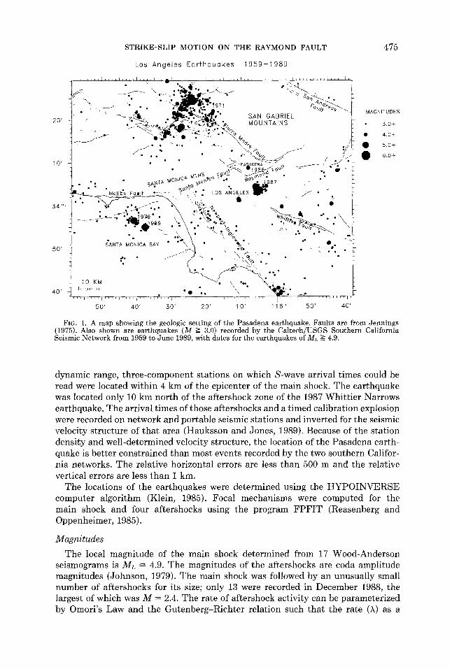
An earthquake with a local magnitude of 4.9 occurred on 3 December 1988, 16 km below the city of Pasadena, in the northeastern Los Angeles basin (Fig. 1). This earthquake is the largest recorded in the vicinity of Pasadena since the installation of the Pasadena and Mount Wilson seismic stations in the 1920s, and no other earthquake of ML >= 2.5 can be associated with any of the mapped faults in the area. The epicenter of this earthquake lies south of the north-dipping Sierra Madre fault, which crops out at the base of the San Gabriel Mountains (Crook et al., 1987) and north of the Elysian Park fold and thrust system that produced the M L = 5.9 Whittier Narrows earthquake of 1987 (Davis et al., 1989; Hauksson, 1990; Hauksson and Jones, 1989). The closest recognized active fault in the vicinity of the Pasadena earthquake is the Raymond fault, a fault for which the nature of slip has been a matter of debate for several decades.
Because the Pasadena earthquake occurred at 16 km depth and did not cause surface rupture, it is not possible to determine unambiguously which fault produced the earthquake. Nonetheless, the seismological data are most consistent with the earthquake having been generated by the Raymond fault. The hypocenters of the earthquake and its aftershocks are coplanar with the surficial trace of the steeply north-dipping Raymond fault. However, the focal mechanism of the earthquake indicates that motion on this plane was left-lateral strike-slip, contrary to the conclusion of Buwalda (1940) that the Raymond fault is a reverse fault. In fact, our geomorphologic and geologic analysis of the fault zone provide a strong basis for the argument that the fault is, indeed, dominantly left-lateral. Thus, the Pasadena earthquake appears to have resolved a significant ambiguity concerning the nature of the Raymond fault. This paper presents the seismologic and geologic evidence for sinistral strike-slip movement on the Raymond fault.
DATA AND ANALYSIS
The Pasadena earthquake was recorded by the Caltech-USGS Southern Califor- nia Seismic Network and the USC Los Angeles Basin Seismic Network. Two wide-
474
STRIKE-SLIP MOTION ON THE RAYMOND FAULT 475
Los Ange les Ear fhquQkes 1 9 5 9 - 1 9 8 9
MAGNITUDES
20' ~ ~ ~ . ~%~ MOUNTAINS 3.0+
• • " - . - ' - - % / • 5 . 0 +
t ~ ~ " - ~ ""
~ ~ Z ios ~GEIES ~ 71 • - •
: : " j - - - . . • . .
\ " ' .
4 0 l i [ ] . . . . ' . . . . ~ . . . . ~ ' I ' I . . . . ' . . . . ~ . . . . . . . . . I . . . . ' . . . . I ' ~ ~ : [ i ~ ' ] . . . . . . . . .
50' 40' 30' 20' 10' 118 ° 50' 40'
FIG. 1. A map showing the geologic setting of the Pasadena earthquake. Faults are from Jennings (1975). Also shown are earthquakes (M _-__ 3.0) recorded by the Caltech/USGS Southern California Seismic Network from 1959 to June 1989, with dates for the earthquakes of ML -> 4.9.
dynamic range, three-component stations on which S-wave arrival times could be read were located within 4 km of the epicenter of the main shock. The earthquake was located only 10 km north of the aftershock zone of the 1987 Whittier Narrows earthquake. The arrival times of those aftershocks and a timed calibration explosion were recorded on network and portable seismic stations and inverted for the seismic velocity structure of that area (Hauksson and Jones, 1989). Because of the station density and well-determined velocity structure, the location of the Pasadena earth- quake is better constrained than most events recorded by the two southern Califor- nia networks. The relative horizontal errors are less than 500 m and the relative vertical errors are less than 1 km.
The locations of the earthquakes were determined using the HYPOINVERSE computer algorithm (Klein, 1985). Focal mechanisms were computed for the main shock and four aftershocks using the program FPFIT (Reasenberg and Oppenheimer, 1985).
Magnitudes The local magnitude of the main shock determined from 17 Wood-Anderson
seismograms is ML -- 4.9. The magnitudes of the aftershocks are coda amplitude magnitudes (Johnson, 1979). The main shock was followed by an unusually small number of aftershocks for its size; only 13 were recorded in December 1988, the largest of which was M -- 2.4. The rate of aftershock activity can be parameterized by Omori's Law and the Gutenberg-Richter relation such that the rate (X) as a
476 L. M. J O N E S ET AL.
function of t ime (t) and magnitudes of the aftershocks (M) and main shock (M~) is:
X(t, M) = 1 0 a -b(M~-M) • ( t -t- c ) - p
where a, b, p, and c are constants (Reasenberg and Jones, 1989). The mean values for 70 California aftershock sequences are a = -1.67, b = 0.92 and p -- 1.03, while the values for the Pasadena aftershock sequence are a = -3.53, b = 1.19 __ 0.32, and p -- 1.44. Thus, the Pasadena sequence has both a high b-value and high p-value (fast decay rate). The a-value, or productivi ty of the sequence, is the lowest yet determined for a California aftershock sequence. The high b-value and low a value mean very few aftershocks of small magnitude. For comparison, the values for the 1987 Whit t ier Narrows aftershock sequence are a = -1.41, b = 0.67 _ 0.05, and p -- 1.51 (Hauksson and Jones, 1989). The 1987 event had relatively few aftershocks but their magnitudes were large, so tha t the overall productivi ty of the sequence was close to average. The one similarity between the 1987 and 1988 sequences is the relatively rapid decay of both sequences.
Locations and Focal Mechanisms
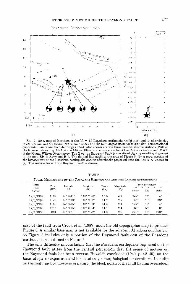
The Pasadena ear thquake was located at 34°8.47'N, 118°7.96'W, at a depth of 16 km (Fig. 2). The nearest seismic station was less than i km to the southeast on the Caltech campus. Wi th five well distributed stations located within a focal depth of the earthquakes and S-wave arrival t imes determined from horizontal compo- nents at three of the five stations even for the main shock, the hypocenters of main shock and aftershocks are exceptionally well constrained. The aftershock epicenters form a narrow east -nor theast t rending distribution, parallel to the strike of the Raymond fault, about 3 km long with the main shock in the middle. The aftershocks are all located in a 3 km band above the main shock.
The focal mechanism of the main shock determined from first motion polarities can be interpreted as dominant ly left-lateral strike-slip motion on a plane striking N67°E and dipping 75 ° to the nor th (Fig. 2). A very slight rake of 4 ° indicates a minor component of reverse slip. The focal mechanism is well constrained with 157 first motions used. Four aftershocks are large enough to determine focal mechanisms and these also show left-lateral strike-slip on an east-northeast-s t r iking planes (Table 1, Fig. 2). The locations and focal mechanisms taken together show tha t the Pasadena ear thquake resulted from left-lateral strike-slip motion (a rake of 2 ° to 8 °) at a depth of 13 to 16 km on a fault striking N65°E to N70°E and dipping 70 ° to 75 °.
Geologic Evidence
The Raymond fault is coplanar with the fault tha t produced the Pasadena earthquake. The Raymond fault strikes N65°E to N85°E and dips northward, towards the source of the earthquake. The 70 ° to 75 ° dip of the Raymond fault preferred by Buwalda (1940) on the basis of admit tedly sparse and poor exposures is nearly equal to the 75 ° dip of the nor theas t - t rending plane of the main shock's focal mechanism. This 75° plane projects from the hypocenter of the ear thquake to within a kilometer of the surface trace of the fault.
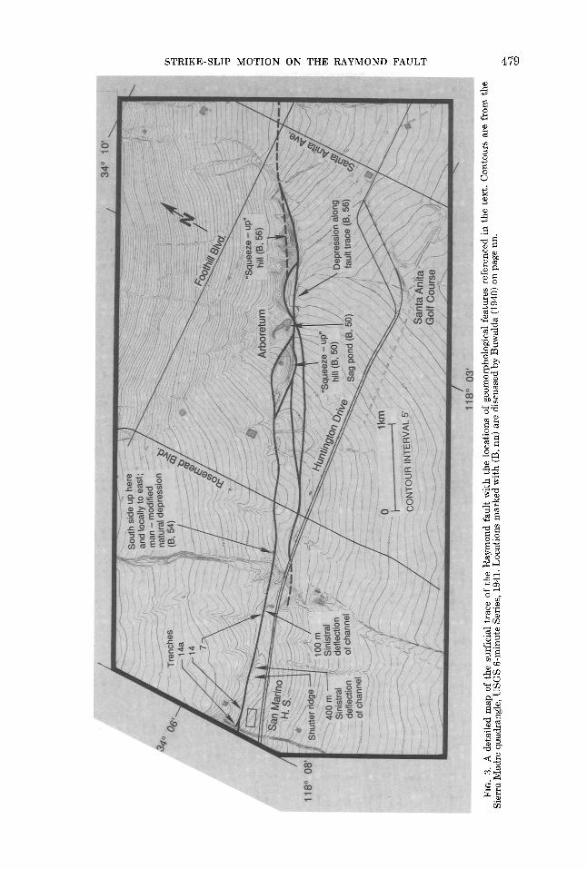
The most detailed map of the surface traces of the Raymond fault is tha t of Crook et al. (1987). The best topographic map of the region is a special edition of the Sierra Madre quadrangle (USGS, 6-minute series, 1941) which was published without cultural information obscuring the topography. We have overlain the
STRIKE-SLIP MOTION ON THE RAYMOND FAULT 4 7 7
15'
12'
11'
10'
9'
8'
7'
6'
5'
5 4 c
1 1 8 °
Pesodene December 1988
v J v v ~
\ ~ierre @Odr
o 0 z \
,5 KM I r I i
12' 11' 10' 9' 8' 7' 6' 5' 4' .~' 2'
(a)
c~
Raymon , A F0ult /~
°t ,, - 4
- 5
6
- 7
- 8
- 9
10
11
12
13 o~
14 ~:~o°
16
0 2 4 D~stance (Km~
(b) FIG. 2. (a) A map of locations of the ML = 4.9 Pasadena earthquake (solid star) and its aftershocks.
Focal mechanisms are shown for the main shock and the four largest aftershocks with dark compressional quadrants. Faults are from Jennings (1975). Also shown are the three nearest seismic stations, PAS at the Kresge Laboratory, GSA at the USGS Office on the western edge of the Caltech campus, and MWC at the Mount Wilson Observatory. The X on the Raymond Fault is the site of the stream offset discussed in the text. RH is Raymond Hill. The dashed line outlines the area of Figure 3. (b) A cross section of the hypocenters of the Pasadena earthquake and its aftershocks projected onto the line A-A' shown in (a). The surface trace of the Raymond fault is shown.
TABLE i
FOCAL M E C H A N I S M S OF THE P A S A D E N A E A R T H Q U A K E AND THE LARGER AFTERSHOCKS
Origin Time Latitude Longitude Depth Magnitude D ate
(UT) (N) (W) (kin) (ML) (m/d/y)
Focal Mechanism
Strike Dip Rake
12/3/1988 1138 34 ° 8.47' 118 ° 7.96' 15.6 4.9 247 ° 75 ° 4 ° 12/3/1988 1149 34 ° 7.90' 118 ° 9.03' 14.7 2.2 55 ° 70 ° 30 ° 12/3/1988 1156 34 ° 8.38' 118 ° 7.63' 14.4 2.4 247 ° 75 ° 4 ° 12/3/1988 1215 34 ° 8.08' 118 ° 8.64' 14.1 2.4 35 ° 85 ° 0 ° 12/4/1988 801 34 ° 8.21' 118 ° 7.78' 14.0 2.0 340 ° 75 ° 170 °
m a p o f t h e f a u l t f r o m C r o o k e t al. ( 1 9 8 7 ) u p o n t h e o l d t o p o g r a p h i c m a p t o p r o d u c e
F i g u r e 3. A s i m i l a r b a s e m a p is n o t a v a i l a b l e for t h e a d j a c e n t A l t a d e n a q u a d r a n g l e ,
so F i g u r e 3 i n c l u d e s o n l y a p o r t i o n o f t h e R a y m o n d f a u l t e a s t o f t h e P a s a d e n a e a r t h q u a k e , as o u t l i n e d i n F i g u r e 2.
T h e o n l y d i f f i c u l t y i n c o n c l u d i n g t h a t t h e P a s a d e n a e a r t h q u a k e o r g i n a t e d o n t h e
R a y m o n d f a u l t a r i s e s f r o m t h e g e n e r a l p e r c e p t i o n t h a t t h e s e n s e o f m o t i o n o n
t h e R a y m o n d f a u l t h a s b e e n r e v e r s e . B u w a l d a c o n c l u d e d ( 1 9 4 0 , p. 4 2 - 4 5 ) , o n t h e
b a s i s o f s p a r s e e x p o s u r e s a n d h i s d e t a i l e d g e o m o r p h o l o g i c a l o b s e r v a t i o n s , t h a t s l ip
o n t h e f a u l t h a s b e e n r e v e r s e i n n a t u r e , t h e b l o c k n o r t h o f t h e f a u l t h a v i n g o v e r r i d d e n
478 L. M. J O N E S E T AL.
the block south of the fault. His conclusion was strongly influenced by the prominent south-facing scarp along the western portion of the fault and the northward dips he observed in a quarry east of Raymond Hill. He also argued that the nonlinearity of the trace of the fault ruled out any significant component of lateral slip. Crook et al. (1987) concurred with Buwalda's conclusion, but acknowledged evidence for "significant" left-lateral displacement as well.
Buwalda's conclusion is suspect, for several reasons. First, many strike-slip faults show a high degree of irregularity. A comparison of the irregularity of the trace of the fault (Fig. 3) with that of the San Andreas (as shown by Vedder and Wallace, 1970, for example) shows that the Raymond is not more irregular than parts of the San Andreas. Second, a dominantly reverse sense of motion is not consistent with several specific observations made by Buwalda himself. He noted many geomorphic features common along strike-slip faults, some of which are noted in Figure 3. In particular, he describes landforms along the eastern portion of the fault that he acknowledged were reminiscent of landforms along the San Andreas fault (Buwalda, 1940, p. 53-54). These include "steep scarps occasionally facing north as well as south, closed depressions and fault ridges" (Buwalda, 1940, p. 42). The reversal of scarp direction, which Buwalda noted as common, is particularly troublesome, unless the sense of fault slip is dominantly lateral. Also difficult to explain are elongate ridges and hillocks within the fault zone.
Crook et al. (1987) concluded, on the basis of their review of Buwalda's observa- tions, coupled with their own, that left-lateral slip constitutes at least a small portion of the slip along the Raymond fault. Actually, their excavations 7, 14, 14a, and 15, dug across the central and eastern portions of the fault (Fig. 3), exposed compelling evidence that lateral slip is dominant over dip slip. Excavation 14, for example, shows a nearly vertical fault that juxtaposes late Pleistocene fluvial beds. None of these beds is traceable across the fault. The Holocene soil which caps these beds is faulted, but no vertical separation is apparent. In these exposures lateral slip must be far greater than vertical slip. For all three excavations where sense of slip could be inferred, Crook et al. (1987) conclude that the sense of motion is predominately strike-slip.
Along the western part of the Raymond fault, the basement is higher south of the fault than north of it (Crook et al., 1987, p. 57). This is another indication that slip along the fault has not been predominantly reverse.
A few stream channels crossing the Raymond fault display sinistral deflections along the fault that could reasonably be interpreted as sinistral offsets (Fig. 3). One tenuous calculation of the ratio of horizontal to vertical slip can be offered, based upon landforms along the western portion of the fault, at the locality shown on Figure 2. Buwalda (1940, p. 46) notes a 1400-foot (427 m) long left-lateral separation of "the drainage channel formed by the uniting of the ravines followed by South Los Robles and South E1 Molino Avenues" along the base of the scarp. We measure a separation of 330 m to 500 m from Crook et al. (1987, Plate 2.4). The height of the scarp at this locality is about 30 m. If the sinistral channel separation is, in fact, a left-lateral offset, the horizontal slip is about an order of magnitude greater than the vertical slip. Farther to the east, where the scarp is lower or non-existent, one would expect the ratio of horizontal to vertical offset to be even higher. It is interesting to note that the rake of the slip vector calculated from the stream channel is 3.4 ° to 5.2 ° . The rake of the slip vector for the short-period mechanism of the Pasadena earthquake, between 2 ° and 8 °, is compatible.
STRIKE-SLIP MOTION ON THE RAYMOND FAULT 479
O
O
~ o
480 L. M. JONES ET AL.
DISCUSSION
The generation of the 1987 Whittier Narrows earthquake by a blind thrust, and new seismological and geologic evidence of active folding in the Los Angeles basin (Davis et al., 1989; Hauksson, 1990) have required a re-evaluation of the tectonics of the Los Angeles basin and the southern margin of the central Transverse Ranges. The Pasadena earthquake and associated sinistral slip on the Raymond fault need to be interpreted in this context.
The Raymond fault is located between the Santa Monica Mountains anticlinor- ium (also called the Elysian Park antiform; Hauksson et al., 1988) and the southern edge of the San Gabriel Mountains and Verdugo Mountains-San Rafael Hills (Fig. 1) (Davis et al., 1989). The Santa Monica Mountains anticlinorium is associ- ated with blind thrusts whereas the thrusts of the Verdugo-San Gabriel Mountains outcrop at the surface. These fold and thrust belts reflect north-south compression across the central Transverse Ranges and the Los Angeles basin, caused by the movement of the Pacific Plate around the "Big Bend" of the San Andreas fault.
Crook et al. (1987) interpreted the Raymond fault as the southernmost thrust fault of the Verdugo-San Gabriel thrust system. However, the Whittier Narrows earthquake demonstrated that active thrust faulting is occurring even farther south, along the Santa Monica Mountains anticlinorium. Furthermore, the Pasadena earthquake demonstrated that the Raymond fault is a small, sinistral strike-slip fault between and at an angle to two thrust systems. This configuration might be explained by variable slip rates along the thrust systems. The Santa Monica Mountains anticlinorium has significantly greater topographic relief west of its intersection with the Raymond fault (the Santa Monica Mountains) than to the south (the Repetto Hills). If this topographic relief is an expression of a greater slip rate to the west, the Raymond fault could be a sinistral tear fault required by the rate differential.
Hauksson (1990) interprets the tectonics of the Los Angeles basin in terms of decoupled, overlapping strike-slip and thrust faulting systems. The thrust faulting results in uplift and crustal thickening while the strike-slip faulting results in lateral motion and possibly rotations of large crustal blocks around the "Big Bend" of the San Andreas fault. The recognition of the Raymond fault as a strike-slip fault between two active thrust fault systems further emphasizes the importance of slip partitioning in the tectonics of the Los Angeles basin.
The Pasadena earthquake occurred less than 10 km from the rupture zone of the Whittier Narrows earthquake (Fig. 1). Having two moderate earthquakes in close proximity and only 14 months apart, after 60 years of seismic quiescence, strongly suggests a genetic relationship between the two events. In fact, the coplanarity of the northerly striking focal planes and hypocenters of the Pasadena earthquake and the largest aftershock of the Whittier Narrows earthquake led to an early hypothesis that the source of both earthquakes was a north-northwest trending dextral fault. The alignment of aftershocks along a east-northeast strike contra- dicted this hypothesis. Morever, the hypothesis had no geologic support, because there is no structural or geomorphological evidence for a steeply dipping, active fault along this trend. Although short segments of the Eagle Rock fault, which trends west-northwesterly through the hills west of the hypocenter, show Holocene offsets (Ziony and Jones, 1989), its trend is too westerly to fit either focal mechanism.
Although the Pasadena earthquake clearly resulted from rupture of a different fault than that which produced the Whittier Narrows earthquake, it is still probable
STRIKE-SLIP MOTION ON THE RAYMOND FAULT 481
that the two earthquakes are related in some way. The number of Whit t ier Narrows aftershocks increased noticeably in the week before and after the Pasadena event. The spatial relationship of the Pasadena and Whit t ier Narrows earthquakes is also quite interesting. Two faults were active in the Whit t ier Narrows sequence: a shallow-dipping, east-str iking thrus t fault on which the main shock occurred, and a steeply dipping, northerly striking strike-slip fault on which the largest aftershock occurred. The hypocenter of the Pasadena earthquake lies at the intersection of the projection of the two faults tha t were active in the Whit t ier Narrows earthquake and the Raymond fault. The Raymond fault also changes strike at this site. This level of geometrical complexity at one point suggests that it could be a site of particular stress concentration. This is consistent with the high stress drop for the Pasadena earthquake calculated by Kanamori et al. (1990).
CONCLUSIONS
The strike-slip focal mechanism of the Pasadena earthquake of 3 December 1988 is compatible with left-lateral strike-slip movement along the Raymond fault. Not only does the hypocenter of the earthquake lie near the projected surface trace of the steeply north-dipping fault, but its dominant ly sinistral mechanism is quite compatible with geological evidence for past activity on the Raymond fault. The nor th-south compression of the Los Angeles basin thus results in a complex interaction of both thrus t and strike-slip faulting, causing crustal thickening and lateral movement or rotat ion of crustal blocks.
ACKNOWLEDGMENTS
We thank Jim Mori and Donna Eberhart-Phillips for constructive reviews. E. Hauksson was supported by USGS Grant 14-08-0001-G1328. L.K. Hutton was supported by USGS Cooperative Agreement 14-08-001-A0613. This study would have been impossible without the hard work and dedication of the analysts who process the data of the Southern California Seismic Network. Contribution Number 4774, Division of Geological and Planetary Sciences, California Institute of Technology, Pasadena, California.
REFERENCES
Buwalda, J. P. (1940). Geology of the Raymond Basin. Report to Pasadena Water Department, 131 pp. Crook, R., Jr., C. R. Allen, B. Kamb, C. M. Payne, and R. J. Proctor (1987). Quaternary geology and
seismic hazard of the Sierra Madre and associated faults, western San Gabriel Mountains, California, in Recent Reverse Faulting in the Transverse Ranges, California, U.S. Geol. Surv. Profess. Pap. 1399, 27-64.
Davis T. L., J. Namson, and R. Yerkes (1989). Structural analysis of seismically active compression in the Los Angeles basin and implications for seismic risk, J. Geophys. Res. 94, 9644-9664.
Hauksson, E. (1990). Earthquakes, active faulting and stress in the Los Angeles Basin, J. Geophys. Res. (in press).
Hauksson, E., L. M. Jones, T. L. Davis, L. K. Hutton, A. G. Brady, P. A. Reasenberg, A. J. Michael, R. F. Yerkes, P. Williams, G. Reagor, C. W. Stover, A. L. Bent, A. K. Shakal, E. Etheredge, R. L. Porcella, C. G. Bufe, M. J. S. Johnston, E. Cranswick (1988). The 1987 Whittier Narrows earthquake in the Los Angeles metropolitan area, California, Science 239, 1409-1412.
Hauksson, E. and L. M. Jones (1989). The 1987 Whittier Narrows earthquake sequence in Los Angeles, southern California: seismological and tectonic analysis, J. Geophys. Res. 94, 9569-9590.
Jennings, C. W. (1975). Fault Map O f California with Volcanoes, Thermal Springs and Thermal Wells (Scale 1:750.000), California Division of Mines and Geology Geologic Data Map No. 1.
Johnson, C. E. (1979). I. CEDAR: An approach to the computer automation of short-period local seismic networks; II. Seismotectonics of the Imperial Valley of southern California, Ph.D. Thesis, California Institute of Technology, Pasadena, California.
Klein, F. W. (1985). User's Guide to HYPOINVERSE, a Program for VAX and PC350 Computers to Solve for Earthquake Locations, U.S. Geol. Surv. Open-file Rept. 85-515, 24 pp.
482 L. M. JONES E T AL.
Kanamori, H., J. Mori, and T. H. Heaton (1990). The 3 December 1988 Pasadena earthquake (ML = 4.9) recorded with the very broadband system at Pasadena, Bull. Seism. Soc. Am. 80, 483-487.
Reasenberg, P. A. and L. M. Jones (1989). Earthquake hazard after a main shock in California, Science 243 , 1173-1176.
Reasenberg, P. and D. Oppenheimer (1985). FPFIT, FPPLOT, and FPPAGE: Fortran computer programs for calculating and displaying earthquake fault-plane solutions, U.S. Geol. Surv. Open-file Rept. 85-739, 109 pp.
Vedder, J. G. and R. E. Wallace (1970). Map showing recently active breaks along the San Andreas and related faults between Cholame Valley and Tejon Pass, California, U.S. Geol. Surv. Misc. Geol. Inv. Map 1-574.
Ziony, J. I. and R. F. Yerkes (1985). Evaluating earthquake and surface faulting potential, in Evaluating Earthquake Hazards in the Los Angeles Region: An Earth-Science Perspective, U. S. Geol. Surv. Profess. Pap. I360, 43-92.
Ziony, J. I. and L. M. Jones (1989). Map showing late Quaternary faults and 1978-1984 seismicity of the Los Angeles region, California, U. S. Geol. Surv. Misc. Series Map MF-1964.
U. S. GEOLOGICAL SURVEY 525 WILSON AVENUE PASADENA, CALIFORNIA 91106
(L.M.J.)
DIVISION OF GEOLOGICAL AND PLANETARY SCIENCES
CALIFORNIA INSTITUTE OF TECHNOLOGY PASADENA, CALIFORNIA 91125
(K.E.S.)
DEPARTMENT OF GEOLOGICAL SCIENCES UNIVERSITY OF SOUTHERN CALIFORNIA LOS ANGELES, CALIFORNIA 90089-0740
(E.H.)
SEISMOLOGICAL LABORATORY CALIFORNIA INSTITUTE OF TECHNOLOGY PASADENA, CALIFORNIA 91125
(L.K.H.)
Manuscript received 18 September 1989


![SHOCK[1] - Hypovolemic Shock](https://img.pdfslide.us/doc/110x75/58edc1bc1a28abae538b4711/shock1-hypovolemic-shock.jpg)