Embed Size (px)
Citation preview

Evaluation Report: Roadway Projects
June 2013
Steering Committee Draft June 3, 2013

Steering Committee Draft June 3, 2013

3
Table o
f Co
nten
ts
Table of Contents
Introduction . . . . . . . . . . . . . . . . . . . . . . . . . . . . . . . . . . . . . . . . . . . . . . . . . . . . . . . . . . . . . . . .5
Project Descriptions and Evaluation . . . . . . . . . . . . . . . . . . . . . . . . . . . . . . . . . . . . . . . . . . . . .8
South Portland Circulation and Connectivity (1044) . . . . . . . . . . . . . . . . . . . . . . . . . . . . . . . . . . . . . . .8
Naito/ South Portland Improvements (5013) . . . . . . . . . . . . . . . . . . . . . . . . . . . . . . . . . . . . . . . . . . . .10
Barbur Boulevard Road Diet (5006, 1019) . . . . . . . . . . . . . . . . . . . . . . . . . . . . . . . . . . . . . . . . . . . . . .12
Capitol to Hamilton (1019) Terwilliger to Capitol Highway (5006)
Barbur Boulevard Multimodal Improvements . . . . . . . . . . . . . . . . . . . . . . . . . . . . . . . . . . . . . . . . . . .14 SW 3rd - Terwilliger (4002) Terwilliger - City Limits (5005)
SW Portland I-5 Partial Split Spring Garden Interchange (1037) . . . . . . . . . . . . . . . . . . . . . . . . . . . . .16
SW Portland/Crossroads Multimodal Project (5059) . . . . . . . . . . . . . . . . . . . . . . . . . . . . . . . . . . . . . .18
Capitol Highway Improvements (5009) . . . . . . . . . . . . . . . . . . . . . . . . . . . . . . . . . . . . . . . . . . . . . . . .20
Boones Ferry Road Improvements - Madrona to Kruse Way (5004) . . . . . . . . . . . . . . . . . . . . . . . . . .22
Highway 217 Overcrossing-Hunziker Hampton Connection (1107) . . . . . . . . . . . . . . . . . . . . . . . . . .24
Upper Boones Ferry at 72nd and Durham (1121) . . . . . . . . . . . . . . . . . . . . . . . . . . . . . . . . . . . . . . . .26
Highway 217 / 72nd Avenue Interchange Improvements (1149) . . . . . . . . . . . . . . . . . . . . . . . . . . . .28
Boones Ferry Road: Martinazzi to Lower Boones Ferry (1134) . . . . . . . . . . . . . . . . . . . . . . . . . . . . . .30
I-5 Southbound Auxiliary Lane: Lower Boones Ferry Interchange (1008B) . . . . . . . . . . . . . . . . . . . .32
Tualatin-Sherwood Rd . Widening (1154) . . . . . . . . . . . . . . . . . . . . . . . . . . . . . . . . . . . . . . . . . . . . . . .34
Arrow (Herman Road) (1062) . . . . . . . . . . . . . . . . . . . . . . . . . . . . . . . . . . . . . . . . . . . . . . . . . . . . . . . .36
Narrowing Methodology . . . . . . . . . . . . . . . . . . . . . . . . . . . . . . . . . . . . . . . . . . . . . . . . . . . . .39
Summary table of roadway project capital costs and right of way impacts . . . . . . . . . . . .40
Steering Committee Draft June 3, 2013

4
Intro
du
ction
List of Figures
Figure 1 South Portland Circulation and Connectivity Project . . . . . . . . . . . . . . . . . . . . . . . . . . . . . . . . . . . . . . . 8
Figure 2 South Portland Circulation and Connectivity Project and Modeling Influence Areas . . . . . . . . . . . . . 8
Figure 3 South Portland Circulation and Connectivity Travel Time Routes . . . . . . . . . . . . . . . . . . . . . . . . . . . . . 9
Figure 4 Naito/ South Portland Improvements Project . . . . . . . . . . . . . . . . . . . . . . . . . . . . . . . . . . . . . . . . . . . . 10
Figure 5 Naito/ South Portland Improvements Project and Modeling Influence Areas . . . . . . . . . . . . . . . . . . 10
Figure 6 Barbur Boulevard Road Diet Project and Modeling Influence Areas . . . . . . . . . . . . . . . . . . . . . . . . . . 12
Figure 7 Barbur Boulevard Road Diet Travel Time Routes . . . . . . . . . . . . . . . . . . . . . . . . . . . . . . . . . . . . . . . . . . 13
Figure 8 Barbur Boulevard Multimodal Improvements Project Area . . . . . . . . . . . . . . . . . . . . . . . . . . . . . . . . . 14
Figure 9 Barbur Boulevard Multimodal Improvements Civic Corridors . . . . . . . . . . . . . . . . . . . . . . . . . . . . . . . 15
Figure 10 SW Portland I-5 Partial Split Spring Garden Interchange Project . . . . . . . . . . . . . . . . . . . . . . . . . . . . 16
Figure 11 SW Portland I-5 Partial Split Spring Garden Interchange Modeling Influence Area . . . . . . . . . . . . . 16
Figure 12 SW Portland I-5 Partial Split Spring Garden Interchange Travel Time Routes . . . . . . . . . . . . . . . . . . 17
Figure 13 SW Portland/Crossroads Multimodal Project . . . . . . . . . . . . . . . . . . . . . . . . . . . . . . . . . . . . . . . . . . . . 18
Figure 14 SW Portland/Crossroads Multimodal Project and Modeling Influence Areas . . . . . . . . . . . . . . . . . . 18
Figure 15 Capitol Highway Improvements Project Area . . . . . . . . . . . . . . . . . . . . . . . . . . . . . . . . . . . . . . . . . . . 20
Figure 16 Capitol Highway Improvements Cross-section . . . . . . . . . . . . . . . . . . . . . . . . . . . . . . . . . . . . . . . . . . . 21
Figure 17 Boones Ferry Road Improvements - Madrona to Kruse Way Project Area . . . . . . . . . . . . . . . . . . . . 22
Figure 18 Boones Ferry Road Improvements - Madrona to Kruse Way Project . . . . . . . . . . . . . . . . . . . . . . . . . 23
Figure 19 Highway 217 Overcrossing-Hunziker Hampton Connection Project Location . . . . . . . . . . . . . . . . . 24
Figure 20 Highway 217 Overcrossing-Hunziker Hampton Connection Project and Modeling Influence Areas 24
Figure 21 Highway 217 Overcrossing-Hunziker Hampton Connection Travel Time Route . . . . . . . . . . . . . . . . 25
Figure 22 Upper Boones Ferry at 72nd and Durham Project and Modeling Influence Areas . . . . . . . . . . . . . . 26
Figure 23 Upper Boones Ferry at 72nd and Durham Travel Time Route . . . . . . . . . . . . . . . . . . . . . . . . . . . . . . 27
Figure 24 Highway 217 / 72nd Avenue Interchange Improvements Project and Modeling Influence Areas . . 28
Figure 25 Highway 217 / 72nd Avenue Interchange Improvements Project . . . . . . . . . . . . . . . . . . . . . . . . . . . 28
Figure 26 Boones Ferry Road: Martinazzi to Lower Boones Ferry Project Area . . . . . . . . . . . . . . . . . . . . . . . . . 30
Figure 27 Boones Ferry Road: Martinazzi to Lower Boones Ferry Modeling Influence Area . . . . . . . . . . . . . 30
Figure 28 I-5 Southbound Auxiliary Lane: Lower Boones Ferry Interchange Modeling Influence Area . . . . . 28
Figure 29 I-5 Southbound Auxiliary Lane: Lower Boones Ferry Interchange Travel Time Route . . . . . . . . . . . 28
Figure 30 Tualatin-Sherwood Rd . Widening Project and Modeling Influence Areas . . . . . . . . . . . . . . . . . . . . 28
Figure 31 Arrow (Herman Road) Project Area . . . . . . . . . . . . . . . . . . . . . . . . . . . . . . . . . . . . . . . . . . . . . . . . . . . 28
List of Tables
Table 1 Major Roadway Project Bundles . . . . . . . . . . . . . . . . . . . . . . . . . . . . . . . . . . . . . . . . . . . . . . . . . . . . . . . . 7
Table 2 Summary Table of Capital Costs and Right of Way Impacts . . . . . . . . . . . . . . . . . . . . . . . . . . . . . . . . . . 40
Steering Committee Draft June 3, 2013
5
Purpose
The purpose of the Southwest Corridor Plan evaluation process is to assist in and support identifying a preferred strategy for the corridor. The purpose of this report is to document the analysis of a subset of the roadway projects that met the initial project screening for the Southwest Corridor Transportation Plan. The subset of projects described and evaluated in this report include those with:
• Traffic impacts that could be measured by the regional travel demand model
• Relatively high costs.
This report focuses on roadway projects and the evaluation focuses on the transportation-related impacts of roadway projects. A companion report focuses on active transportation projects and impacts to the active transportation system.
Methodology
Evaluation framework
The analysis in this report is derived from the vision adopted by the SW Corridor Plan Steering Committee and the following goals and objectives:
Goal: Accountability and partnership – Manage resources responsibly, foster collaborative investments, implement strategies effectively and fairly, and reflect community support.
Objectives:
• Build upon existing plans, private development and investments in public infrastructure
• Make investments that maximize limited resources
• Equitably distribute the benefits and burdens of growth geographically and demographically
Measures used to evaluate the accountability and partnership goal and objectives include:
• Cost
• Support for transit investment
IntroductionIntroduction
Goal: Prosperity – People can live, work, play and learn in thriving and economically vibrant communities where everyday needs are easily met.
Objectives:
• Develop communities that provide education, jobs, services, shopping and recreation
• Stimulate potential for private investment
• Support a wide variety of employment
• Improve opportunities for affordable living, considering the combined housing, transportation and utility costs
Goal: Health – An environment that supports the health of the community and ecosystems.
• Develop transportation facilities and urban form that enhance the natural environment
• Support active and healthy lifestyles
• Strive to enhance the natural environment to improve ecosystem function and air and water quality
Goal: Access and mobility – People have a safe, efficient and reliable network that enhances economic vitality and quality of life.
Objectives:
• Improve access to places where people live, work, play and learn
• Improve access, mobility and safety for all transportation modes, ages and physical abilities
• Improve the freight transportation system to ensure that the region and its businesses stay economically competitive.
Steering Committee Draft June 3, 2013

6
Measures used to evaluate the access and mobility goal and objectives include:
• Travel time
• Vehicle hours of delay (VHD)
• Change in travel patterns
• Vehicles miles travelled (VMT)
• Connectivity
• Pedestrian/Bicycle impacts
Bundles
The approach adopted for this evaluation was to combine the roadway and active transportation projects into “bundles” with each of the five high capacity transit projects. Table 1 on the following page shows which projects were included in each bundle. The affects of projects combined in the bundles, if any, on the model results are discussed in this report.
Costs
Capital costs are planning-level costs escalated to 2022, to represent year-of-expenditure dollars and maintain a consistent base of comparison. This report uses the planning-level estimates of projects from source documents, for example, the 2035 Regional Transportation Plan, a transportation system plan, or a corridor plan. If the source document did not include cost estimates, project staff used professional judgment to produce planning-level estimates.
Modeling
Metro’s regional travel demand model was used to perform a planning-level assessment of major roadway projects. All modeling results reported are for the evening peak one hour, 5-6 PM. The model determines the changes in vehicle travel patterns and travel times expected to result from changes to the roadway network, providing a means of testing candidate roadway projects. The model is an estimate of future 2035 vehicle demand based on land use and roadway and transit
IntroductionIntroduction
network assumptions, and it provides a means for determining the relative changes in transportation performance. Performance measures such as roadway traffic volumes, vehicle delay, and changing travel times can be estimated for each project bundle, allowing the roadway impacts of each project to be estimated.
Narrowing
The evaluation of projects in this document focuses on transportation performance, however planning for the SW Corridor focuses on the desire for transportation investments to support the desired land use. The goals and objectives adopted for the plan provide the criteria for this narrowing. In addition to the transportation performance, a narrowing process provides an opportunity to evaluate projects against all the goals and objectives for the plan. A section on narrowing in this report explains the methodology and criteria used for narrow.
Steering Committee Draft June 3, 2013

7
Intro
du
citon
Project #
Project Title A: LRT Tigard
B: BRT Tigard
C: BRT Tualatin
D: BRT Sherwood
E: Hub & Spoke
1044 South Portland Circulation and Connectivity
X X
5013 Naito/South Portland Improvements
X
1019, 5006
Barbur Lane Diet X X
4002, 5005
Barbur Blvd. Multi-modal Improvements
X X X X
1037 SW Portland I-5 Partial Split Spring Garden Interchange
X
5059 SW Portland/ Crossroads Multimodal Project
X X
5009 Capitol Highway Improvements X5004 Boones Ferry Road Improvements
- Madrona to Kruse WayX
1107 Highway 217 Over-crossing - Hunziger Hampton Connection
X X X X X
1121 Upper Boones Ferry at 72nd and Durham
X X
1149 Highway 217/72nd Ave. Interchange Improvements
X
1134 Boones Ferry Road: Martinazzi to Lower Boones Ferry
X X X
1008B I-5 Southbound Auxiliary lane: Lower Boones Ferry interchange
X X
1154 Tualatin-Sherwood Rd. Widening X X X X
1062 Arrow Street (Herman Road) X X
Table 1 Major Roadway Project Bundles
Introduction
Steering Committee Draft June 3, 2013

8
Roadways: South Portland C
irculation and Connectivity (1044)
Project description
$28.4M (2022)
Restores the neighborhood grid and connectivity along Naito Parkway by restoring seven at-grade intersections from SW Sheridan to SW Grover St.
Adds new signalized intersections at SW Naito Parkway/Hooker and SW Kelly/Water.
Builds a new signalized intersection at SW Naito Parkway and Ross Island Bridge access that allows for removal of several existing roadways and ramp connections.
Adds a new ramp connection from SW Kelly (southbound) that passes beneath the Ross Island Bridge west of SW Hood Avenue.
Provides a revised southbound connection between US 26 and I-405 along Kelly Avenue.
South Portland Circulation and Connectivity (1044)
Figure 2 South Portland Circulation and Connectivity Project and Modeling Influence Areas
Project purpose
Enhance neighborhood connectivity across SW Naito Parkway.
Improve connectivity, safety, and street environment for cyclists and pedestrians; shift through traffic from neighborhood streets onto Kelly Avenue.
Modeling assumptions
• Removes several existing ramp connections to and from the Ross Island Bridge
• Adds a new ramp connection from SW Kelly (southbound) to the Ross Island Bridge eastbound
• Maintains two lanes in each direction on SW Naito Parkway north of Ross Island Bridge
• Adds new signalized intersections along SW Naito Parkway at Ross Island Bridge and at SW Hooker Street
• Adds two signalized connections along Kelly Avenue north of the Ross Island Bridge off-ramp.
.5 Miles
Figure 1 South Portland Circulation and Connectivity Project
Project Area
Steering Committee Draft June 3, 2013

9
Roadways: South Portland C
irculation and Connectivity (1044)
Evaluation results
Summary
The project performs consistently with its purpose of redirecting the Ross Island Bridge traffic along Kelly Avenue. Some redirection of auto traffic from Naito to Kelly occurs, although a substantial amount remains on Naito. Overall vehicle delay increases as the system capacity is reduced.
Change in travel patterns
• This project converts the ramps between the Ross Island Bridge and Naito into an at-grade intersection, and increases the use of Kelly to access the bridge.
• Traffic from the west on US 26 (Arthur) continues on Kelly rather than turning south onto Naito to access the bridge. As a result, traffic on Kelly increases 7% while traffic on Naito Parkway south of Arthur/Kelly drops by 15%-25%.
• Traffic on the bridge drops 3% due to the revised access.
• Freeway travel patterns do not measurably change.
Route travel time
• During the PM peak hour, the average auto travel time between I-405 and the Ross Island Bridge increases by about 5 seconds northbound and 20 seconds southbound.
Area-wide delay
• This project increases vehicle hours of delay (VHD) in the influence area by 4%. Most of the additional delay is for vehicles accessing the Ross Island Bridge from the west.
• This project reduces vehicle miles traveled (VMT) in the influence area by 2%.
South Portland Circulation and Connectivity (1044)
Connectivity
These projects (5013 and 1044) increase connectivity in a neighborhood with a fragmented street grid.
Bike/Pedestrian
This project improves walking and bicycling conditions in the neighborhood by restoring street connectivity across Naito Parkway.
Figure 3 South Portland Circulation and Connectivity Travel Time Routes
Exisiting northbound - Ross Island Bridge to 12th Ave. I-405 off-ramp
Existing southbound - I-405 6th Ave. off-ramp to Ross Island Bridge
Steering Committee Draft June 3, 2013

10
Roadways: N
aito/South Portland improvem
ents (5013)
Project description
$51.2M (2022)
Reconstructs Naito Parkway as a two-lane neighborhood collector street with bike lanes, sidewalks, left turn pockets and on-street parking.
Removes grade separations along Naito at Barbur, the Ross Island Bridge, Arthur/Kelly, and the Gibbs pedestrian bridge.
Restores the neighborhood grid along Naito Parkway by restoring 17 at-grade intersections from SW Sheridan to SW Lowell St.
Reconfigures Naito Parkway and Kelly Avenue as an at-grade signalized intersection.
Reconfigures and realigns Naito Parkway and Barbur Blvd. as an at-grade signalized intersection.
Naito/South Portland Improvements (5013)
Figure 5 Naito/ South Portland Improvements Project and Modeling Influence Areas
Project purpose
Improve connectivity and create a multimodal neighborhood street character on Naito Parkway
Modeling assumptions
• Reduces vehicle capacity on SW Naito Parkway to one lane in each direction with turn lanes.
• Adds signalized intersections on Naito Parkway at Kelly Avenue and at Barbur Blvd.
• Removes existing ramp connections between Ross Island Bridge and Naito Parkway.
• For modeling this project does not stand alone in any bundle. This project is in the BRT to Sherwood run with the South Portland Circulation project (1044)
Roadways: N
aito/South Portland Improvem
ents (5013)
.5 Miles
Figure 4 Naito/ South Portland Improvements Project
Project Area
Steering Committee Draft June 3, 2013

11
Roadways: N
aito/South Portland improvem
ents (5013)
Evaluation results
Summary
The project performs consistently with its purpose of converting Naito to a neighborhood-scale street, and redirecting the Ross Island Bridge traffic along Kelly Avenue. About half of Naito’s auto traffic is diverted to other streets, especially Kelly and Barbur. Overall vehicle delay increases as the system capacity is reduced.
Change in travel patterns
• This project, in conjunction with South Portland Circulation and Connectivity (1044), reconstructs Naito Parkway as a neighborhood collector type street, and removes grade separations at Arthur/Kelly and Barbur. The result is reduced vehicle demand on Naito Parkway.
• Traffic accessing the bridge from the west and north is primarily directed along Kelly. As a result, traffic on Kelly increases 23% while traffic on Naito south of Arthur/Kelly drops by 45%-60%.
• Traffic on Barbur (parallel to Naito) increases by 22% as through traffic diverts from Naito to Barbur, which has available capacity.
• Traffic on the bridge drops 5% due to the revised travel patterns.
• Freeway travel patterns do not measurably change.
Naito/South Portland Improvements (5013)Roadw
ays: Naito/South Portland Im
provements (5013)
Area-wide delay
• In conjunction with South Portland Circulation and Connectivity (1044), this project increases VHD in the influence area by 7%. Most of the additional delay is for vehicles accessing the Ross Island Bridge from the west.
Connectivity
• These projects (5013 and 1044) increase connectivity in a fragmented neighborhood by converting a 1940s-era expressway into a neighborhood-scale street with crossings.
Bike/Pedestrian
• These projects add and improve sidewalks to fill gaps, add pedestrian crossings, add transit amenities, and add or improve bike lanes to fill gaps.
Steering Committee Draft June 3, 2013

12
Project description
$0.3M (2022)
Reduces the number of northbound lanes on Barbur from three to two from Capitol Highway (north) to 1/4 mile south of Hamilton.
Adds buffered bike lanes.
Barbur Boulevard Road Diet (5006, 1019)Roadways: Barbur Boulevard Road D
iet (5006, 1019)
Capitol to Hamilton (1019)
Project description
$0.3M (2022)
Reduces number of northbound lanes on Barbur from two to one from SW Miles Street to Capitol Highway.
Adds bike lanes and widens sidewalks over Newberry and Vermont bridges.
Terwilliger to Capitol Highway (5006)
Project purpose
Reduce vehicle speeds, improve cyclist and pedestrian safety, and close a major bicycle route gap. Intended to reduce speeds and improve safety and improve pedestrian/bike crossing safety.
Modeling assumptions (5006, 1019)
• Reduces northbound lanes and capacity on Barbur Blvd. from Terwilliger to Hamilton Street.
Figure 6 Barbur Boulevard Road Diet Project and Modeling Influence Areas
1 Miles
Steering Committee Draft June 3, 2013

13
Evaluation results
Summary
The proposed road diet projects remove a northbound vehicle travel lane on Barbur Blvd. in order to provide better bicycle facilities. Northbound traffic is the predominant movement in the AM peak, but the study period for the project bundles was the PM peak. Additional analysis is therefore needed to draw conclusions about these two projects. Tools such as Synchro and dynamic traffic assignment models may be employed in a more detailed evaluation.
Bike/Pedestrian
• The removal of a travel lane provides space for improved bicycle and/or pedestrian facilities improving the comfort of people walking and bicycling.
• A reduction in the number of vehicle lanes would be expected to reduce average vehicle speeds, improving the comfort and safety of people walking and bicycling.
Barbur Boulevard Road Diet (5006, 1019)Roadw
ays: Barbur Boulevard Road Diet (5006, 1019)
Figure 7 Barbur Boulevard Road Diet Travel Time Routes
Barbur -Naito Parkway to Terwilliger
I-5 Terwilliger on-ramp to Hood Avenue off-ramp
Steering Committee Draft June 3, 2013

14
Barbur Boulevard Multimodal Improvements (4002, 5005)Roadways: Barbur Boulevard M
ultimodal Im
provements (4002, 5005)
Project description
$8.5M (2022)
Make improvements for pedestrians and transit riders, including filling sidewalk gaps and making crossing improvements.
Provide transit and roadway improvements including preferential signals, pullouts, shelters, left turn lanes and sidewalks.
Fill bike lane gaps.
SW 3rd to Terwilliger (4002)
Terwilliger to city limits (5005)
Project description
$32M (2022)
Complete boulevard design improvements including adding sidewalks and street trees, filling bike gaps and creating safe pedestrian crossings.
Enhance transit access and stop locations, and bike lanes from Terwilliger Blvd. to 64th Ave.
Project purpose
Improve safety, connectivity, and comfort for transit users, cyclists, and pedestrians
Modeling assumptions (5006, 1019)
• Reduce northbound lanes and capacity on Barbur Blvd. from Terwilliger to Hamilton Street.
• Convert northbound lane to bus only; southbound buses are in mixed traffic.
1 Mile
Figure 8 Barbur Boulevard Multimodal Improvements Project Area
Steering Committee Draft June 3, 2013

15
Evaluation results
Bike/Pedestrian
These projects add and improve sidewalks to fill gaps, add pedestrian crossings, add transit amenities, and add or improve bike lanes to fill gaps.
Barbur Boulevard Multimodal Improvements (4002, 5005)Roadw
ays: Barbur Boulevard Multim
odal Improvem
ents (4002, 5005)
CIVIC CORRIDORS
A civic corridors approach to Barbur Boulevard would tie together Barbur’s transportation modes, increase greenspace and incorporate new urban design prototypes.
Figure 9 Barbur Boulevard Multimodal Improvements
Steering Committee Draft June 3, 2013

16
Project description
$103.1 M (2022)
Reconfigures the I-5 Spring Garden interchange as a partial split.
Creates new I-5 southbound on- and off-ramps to and from Barbur Blvd. just south of SW
26th.
Creates new I-5 northbound on- and off-ramps at Spring Garden Street.
Closes existing southbound off-ramps at Spring Garden and northbound off-ramp at Taylor’s Ferry.
Rebuilds structure over I-5 on Spring Garden Street and widens Spring Garden east of Barbur Blvd.
Project purpose
Create additional access to I-5 southbound; reduce use of Barbur for longer, higher-speed southbound trips; reduce vehicle demand at the Crossroads intersection.
Modeling assumptions
• Adds I-5 southbound on- and off-ramps to and from Barbur Blvd just south of SW 26th
• Adds I-5 northbound off-ramp at Spring Garden Street
SW Portland I-5 Partial Split Spring Garden Interchange (1037)
Figure 11 SW Portland I-5 Partial Split Spring Garden Interchange Modeling Influence Area
Roadways: SW
Portland I-5 Partial Split Spring Garden Interchange (1037)
• Removes existing I-5 northbound off-ramp to Taylor’s Ferry Road
• Removes existing I-5 southbound off-ramps at Spring Garden
• Adds capacity to Spring Garden Street between Barbur Blvd. and SW 19th Ave.
Evaluation results
Summary
The project shifts a substantial amount of traffic from Barbur to I-5 between the new interchange and 65th/Hwy 99-W. Traffic volumes decrease on Taylors Ferry, where the existing off-ramp is removed. System delay increases as additional traffic is attracted to a constrained segment of I-5.
Change in travel patterns
• This project shifts traffic away from Barbur Blvd. to I-5 on the nearby portions of these regional facilities. In the future Barbur Blvd. has very little congestion between Terwilliger and Taylors Ferry Road.
• I-5 northbound, north of Taylors Ferry Road increases by 8% or 440 vehicles/hour, and by 12% or about 600 vehicles/hour southbound (south of the Barbur on-ramp).
.5 Miles
Figure 10 SW Portland I-5 Partial Split Spring Garden Interchange
Steering Committee Draft June 3, 2013
17
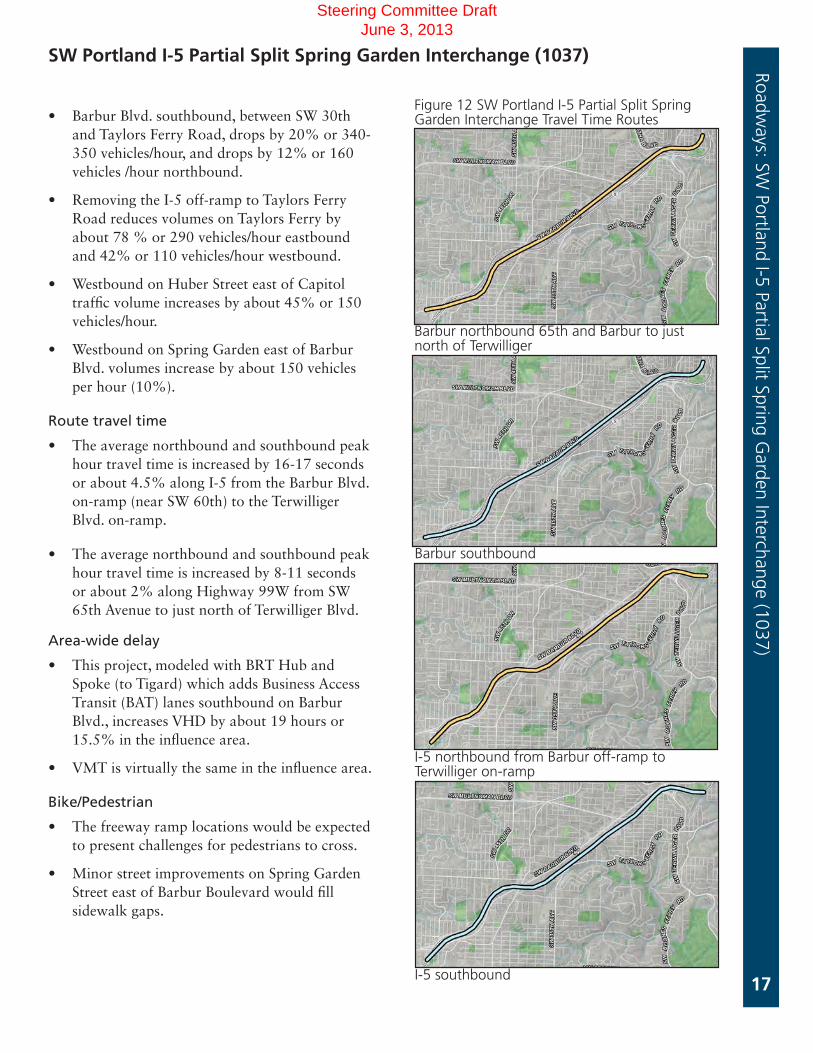
• Barbur Blvd. southbound, between SW 30th and Taylors Ferry Road, drops by 20% or 340-350 vehicles/hour, and drops by 12% or 160 vehicles /hour northbound.
• Removing the I-5 off-ramp to Taylors Ferry Road reduces volumes on Taylors Ferry by about 78 % or 290 vehicles/hour eastbound and 42% or 110 vehicles/hour westbound.
• Westbound on Huber Street east of Capitol traffic volume increases by about 45% or 150 vehicles/hour.
• Westbound on Spring Garden east of Barbur Blvd. volumes increase by about 150 vehicles per hour (10%).
Route travel time
• The average northbound and southbound peak hour travel time is increased by 16-17 seconds or about 4.5% along I-5 from the Barbur Blvd. on-ramp (near SW 60th) to the Terwilliger Blvd. on-ramp.
• The average northbound and southbound peak hour travel time is increased by 8-11 seconds or about 2% along Highway 99W from SW 65th Avenue to just north of Terwilliger Blvd.
Area-wide delay
• This project, modeled with BRT Hub and Spoke (to Tigard) which adds Business Access Transit (BAT) lanes southbound on Barbur Blvd., increases VHD by about 19 hours or 15.5% in the influence area.
• VMT is virtually the same in the influence area.
Bike/Pedestrian
• The freeway ramp locations would be expected to present challenges for pedestrians to cross.
• Minor street improvements on Spring Garden Street east of Barbur Boulevard would fill sidewalk gaps.
SW Portland I-5 Partial Split Spring Garden Interchange (1037)Roadw
ays: SW Portland I-5 Partial Split Spring G
arden Interchange (1037)
Figure 12 SW Portland I-5 Partial Split Spring Garden Interchange Travel Time Routes
Barbur northbound 65th and Barbur to just north of Terwilliger
I-5 southbound
I-5 northbound from Barbur off-ramp to Terwilliger on-ramp
Barbur southbound
Steering Committee Draft June 3, 2013

18
Project description
$51.6 M (2022)
Modifies Barbur Blvd., Capitol Highway, and the I-5 southbound on-ramp.
Project includes various intersection improvement types (such as roundabouts) and roadway realignments to be refined.
Implements Barbur Concept Plan walk audit recommendations in the SW Portland Town Center.
Project includes maintaining two lanes in each direction on Barbur Blvd. between new intersection improvements from Huber Street north to Barbur Transit Station entrance. Project is illustrative of a group of concepts that would change circulation in this area.
SW Portland/Crossroads Multimodal Project (5059)
Figure 14 SW Portland/Crossroads Multimodal Project and Modeling Influence Areas
Project purpose
Support safer and more efficient movements for motorists, transit vehicles, cyclists, and pedestrians
Modeling assumptions
• Adds three roundabouts on Barbur Blvd., (one at north Transit Station entrance, one at Taylors Ferry Road and one at Capitol Highway)
• Adds a signal at Barbur and Huber and restricts southbound left turns from Barbur to Huber Street
• Adds a signal at Capitol Highway and Taylors Ferry Road with added capacity for turn lanes
Roadways: SW
Portland/Crossroads M
ultimodal Project (5059)
1 Mile
Figure 13 SW Portland/Crossroads Multimodal Project
Steering Committee Draft June 3, 2013

19
Evaluation results
Summary
The project shifts traffic away from Barbur Blvd. on onto I-5 on the nearby portions of these parallel regional facilities. The assumed project configuration increases influence area delay, which is primarily due to the roundabout at Barbur Blvd. and Capitol Highway (includes the southbound on-ramp to I-5) being overwhelmed by traffic headed for the I-5 southbound ramp. Further project refinement would be needed to address this demand.
Change in travel patterns
• This project shifts traffic away from Barbur Blvd. onto I-5 on the close by portions of these regional facilities.
• Barbur Blvd. southbound, north of Taylors Ferry Road, drops by 26% or 450 vehicles/hour, and drops by 26 % or 340 vehicles /hour northbound.
• I-5 southbound, north of Taylors Ferry Road increases by 5.5 % or 300 vehicles/hour) and increases by about 2% or 90 vehicles/hour northbound.
• Demand on the Barbur/Capitol roundabout (includes the I-5 on ramp) is about 2,200 vehicles/hour, which is close to the expected capacity.
Route travel time
• See figure 12 travel time route for Spring Garden interchange project on previous page.
• The average northbound and southbound peak hour travel time increases by about 12 seconds or 3.2% along I-5 from the Barbur Blvd. on-ramp (near SW 60th) to the Terwilliger Blvd. on-ramp.
SW Portland/Crossroads Multimodal Project (5059)Roadw
ays: SW Portland/C
rossroads Multim
odal Project (5059)
• The average northbound and southbound peak hour travel time is increased by 38-40 seconds or 8-8.4% along Highway 99W from SW 65th Avenue to just north of Terwilliger Blvd.
Area-wide delay
• With this project VHD iincreases about 16 hours or 13% within the influence area.
• The increase in delay is primarily due to the shift in traffic away from Barbur Blvd. on to I-5, which accounts for additional delay on I-5 both northbound and southbound between Highway 99W and Capitol Highway.
• Increased delay also occurs on Capitol Highway approaching Huber St. and southbound approaching the roundabout at Barbur Blvd.
• VMT decreases by about 1% within the influence area.
Connectivity
• Project maintains existing street connectivity while improving pedestrian and bicycle connectivity with more pedestrian/bike crossings of Barbur Blvd. and Capitol Highway
Bike/Pedestrian
• The intension of the project is to enhance pedestrian and bicycle facilities and create more and safer pedestrian/bike crossings of Barbur Blvd. and Capitol Highway.
Steering Committee Draft June 3, 2013

20
Roadways: N
aito/South Portland improvem
ents (5013)
Project description
$24.6 M (2022)
Improves SW Capitol Highway from SW Multnomah Boulevard to SW Taylors Ferry Road per the Capitol Highway Plan
Replaces existing roadway and adds sidewalks, bike lanes and green stormwater features
Capitol Highway Improvements (5009)
Figure 15 Capitol Highway Improvements Project Area
Modeling assumptions
No modeling impact.
Roadways: C
apitol Highw
ay Improvem
ents (5009)
Steering Committee Draft June 3, 2013

21
Roadways: N
aito/South Portland improvem
ents (5013)
Project purpose
Improve connectivity, safety, and comfort for cyclists and pedestrians
Evaluation results
Bike/Pedestrian
• This project adds sidewalks and bike lanes to a street to improve safety and comfort for people walking and biking.
Capitol Highway Improvements (5009)Roadw
ays: Capitol H
ighway Im
provements (5009)
Figure 16 Capitol Highway Improvements Cross-section
Steering Committee Draft June 3, 2013

22
Boones Ferry Road Improvements – Madrona to Kruse Way (5004)Roadways: Boones Ferry Road Im
provements – M
adrona to Kruse W
ay (5004)
Phase 1
Project description
Phase 2: Oakridge/Reese to Kruse Way
$11.6 M (2022)
Widen to include bike lanes and sidewalks with street trees, lighting and landscaping, median and turn lanes.
Phase 1, Madrona to Oakridge/Reese will be constructed by Lake Oswego within the next five years.
Phase 1 will widen Boones Ferry to include bike lanes, sidewalks with street trees, lighting, street furniture, landscaping, median, and turn lanes, add new signal at Madrona Street and improved pedestrian crosswalks including signalized pedestrian crossing at Lanewood. It will maintain four vehicular travel lanes.
Phase 2
Figure 17 Boones Ferry Road Improvements - Madrona to Kruse Way Project Area
Steering Committee Draft June 3, 2013

23
Project purpose
Improve connectivity, safety, and street environment for cyclists and pedestrians
Modeling assumptions
No modeling impacts.
Evaluation results
Bike/Pedestrian
• This project improves sidewalks and adds pedestrian crossings, transit amenities, and bike lanes along an active retail corridor with the potential for increased walking and biking activity.
Boones Ferry Road Improvements – Madrona to Kruse Way (5004)Roadw
ays: Boones Ferry Road Improvem
ents – Madrona to K
ruse Way (5004)
Figure 18 Boones Ferry Road Improvements - Madrona to Kruse Way Project
Steering Committee Draft June 3, 2013

24
Project description
$66.3M (2022)
Builds new connection of Hunziker Road to 72nd Avenue at or near Hampton St. with a new over-crossing of Highway 217.
Signalizes new roadway connection at 72nd Avenue.
Modifies existing 72nd Avenue/Hunziker intersection/connection.
Project purpose
Provide improved multimodal access between the Tigard Triangle and downtown Tigard. The intent is to improve operations at the ramp terminals, 72nd Avenue and streets intersecting 72nd Avenue, not the mainline of Highway 217.
Modeling assumptions
• Adds a new two-lane roadway connection Hunziker Road to 72nd Avenue at Hampton Street (over-crossing of Highway 217).
• Removes the existing link on Hunziker Road that connects to 72nd Avenue south of Highway 217.
Evaluation results
Summary
• The new bridge carries about 1,400 vehicles during the PM peak hour. The new route shifts some traffic away from the Dartmouth/99-W intersection, which is constrained, and adds connectivity for all modes between the Tigard Triangle and downtown Tigard. The additional traffic attracted to Hunziker creates additional demand for the Hall/Hunziker/Scoffins intersection realignment project (1100).
Highway 217 Overcrossing - Hunziker Hampton Connection (1107)
Figure 20 Hwy 217 Overcrossing-Hunziker Hampton Connection Project and Modeling Influence Areas
Roadways: H
ighway 217 O
vercrossing-Hunziker H
ampton C
onnection (1107)
Project Area .5 Miles
Figure 19 Highway 217 Overcrossing-Hunziker Hampton Connection Project Location in SW Corridor
Steering Committee Draft June 3, 2013

25
Change in travel patterns
• Westbound traffic increases by about 53 % or 300 vehicles/hour on Hunziker Street; eastbound remains about the same. The westbound traffic increase will put pressure on the Hunziker/ Hall/ Scoffins intersection.
• In combination with the Atlanta Street Extension (1078), this project takes about 300 vehicles/hour, a 28 to 38% decrease, off of Dartmouth Street (west of 72nd) in each direction.
• Dartmouth Street peak hour volumes at the westbound approach to Highway 99W will cause some congestion that would be relieved by the new Hunziker Hampton connection.
Route travel time
• The average westbound and eastbound auto travel times are reduced by 25 – 30 seconds between SW Main/SW Tigard Street in downtown Tigard and SW 66th Ave. /SW Hampton Street. Westbound this is an 8 – 9% reduction in travel time.
Area-wide delay
• This project, High Capacity Transit (HCT), and the Atlanta Street Extension, all would affect the VHD within the influence area.
• With the addition of HCT and without the 72nd Ave. minor widening projects, VHD is reduced by 1.6 to 1.9%.
• With HCT and the 72nd Ave. projects included, VHD in the influence area remains about the same.
• Vehicle miles traveled (VMT) remains the same with this project
Highway 217 Overcrossing-Hunziker Hampton Connection (1107) Roadways: H
ighway 217 O
vercrossing-Hunziker H
ampton C
onnection (1107)
Connectivity
This project provides a faster, more direct connection for motorist, transit riders, bicyclist and pedestrians between downtown Tigard and the Tigard Triangle and supports the use of HCT (with transit on the new structure) and provides a new roadway with bike lanes and sidewalks.
Bike/Pedestrian
This project would provide the only ped/bike route free of freeway ramp crossings between the Tigard Triangle and downtown Tigard. It provides for the increase in daily bicyclists travelling on Hunziker and on 72nd from 99W to Bridgeport Village. This project increases the pedestrian connections west of the Tigard Triangle and thereby supports a HCT station in the Tigard Triangle, especially an HCT alignment on 72nd.
Figure 21 Highway 217 Overcrossing-Hunziker Hampton Connection Travel Time Route (current route)
Steering Committee Draft June 3, 2013

26
Project description
$15.0 M (2022)
Realigns and reconfigures the intersection of 72nd/Upper Boones Ferry so that Upper Boones Ferry Road is the through route, creating a more direct route between Durham Road at Upper Boones Ferry Road & I-5/Carman Interchange;
Widens intersection of Durham & Upper Boones Ferry Road;
Widens Upper Boones Ferry to 5 lanes between Durham and I-5.
Project purpose
Create a more efficient and direct vehicle connection between Durham Road and I-5.
Modeling assumptions
• Widens (adds capacity) Upper Boones Ferry Road from 3 lanes to 5 lanes between Durham Road and 72nd/Carman Drive
• Adds capacity for turn lanes at Upper Boones Ferry Road and 72nd Avenue
• Adds capacity for left turn lanes at northbound approach of Upper Boones Ferry/72nd/Carman intersection
Roadways: U
pper Boones Ferry at 72nd and Durham
(1121)
Upper Boones Ferry at 72nd and Durham (1121)
Figure 22 Upper Boones Ferry at 72nd and Durham Project and Modeling Influence Areas
.5 Miles
Steering Committee Draft June 3, 2013

27
Evaluation results
Summary
The creation of a more direct route with additional capacity attracts a substantial amount of traffic along Upper Boones Ferry Road to Durham. No substantial decreases are evident on surrounding streets. The additional capacity results in less overall vehicle delay.
Change in travel patterns
• During the PM peak hour, traffic on Upper Boones Ferry Road north of Durham Road is increased by about 880 vehicles (56%) due to the increased capacity and more direct route.
• During the PM peak hour, traffic on Durham Road at Upper Boones Ferry increased by about 400 vehicles (16%) due to the increased capacity and more direct route.
Route travel time
• The average peak hour auto travel time along 72nd/Upper Boones Ferry Road from Highway 217 to Lower Boones Ferry Road is reduced by 26 to 30 seconds, about 6.5%.
• The average peak hour auto travel time along I-5 is reduced by 7 to 13 seconds, about 2 to 3%.
Area-wide delay
• With the addition of this project, VHD is reduced by about 11% (58 VHD) in the influence area.
• With the addition of this project, VMT is increased by about 2% in the influence area.
Bike/Pedestrian
• This project would fill some sidewalk and bike lane gaps along Upper Boones Ferry Road.
• The widening of Upper Boones Ferry Road and Durham Road would typically be expected to make crossings of the roadway more difficult for pedestrians due to the increased volume, speed, and roadway width.
Upper Boones Ferry at 72nd and Durham (1121) Roadways: U
pper Boones Ferry at 72nd and Durham
(1121)
Figure 23 Upper Boones Ferry at 72nd and Durham Travel Time Route (southbound and northbound)
Steering Committee Draft June 3, 2013

28
Project description
$47.7 M (2022)
Completes interchange reconstruction of new diamond interchange with new ramp alignments or alternative design options
Removes Highway 217 northbound loop on-ramp and replaces with direct northbound on-ramp
New Hunziker-Hampton connection over Highway 217 removes Hwy 217 southbound off-ramp and replaces with direct southbound off-ramp to 72nd
Widens 72nd Avenue overcrossing of Hwy 217 to four lanes plus left-turn lanes between Hampton Street and Varns Street
Highway 217 / 72nd Avenue Interchange Improvements (1149)Roadways: H
ighway 217 / 72nd A
venue Interchange Improvem
ents (1149)
Figure 24 Highway 217 / 72nd Avenue Interchange Improvements Project and Modeling Influence Areas
Modeling Assumptions
Convert existing two-quadrant interchange to diamond interchange
Add lanes and capacity on 72nd Avenue between Hampton Street and Varns Street
Project Area .5 Mile
s
Figure 25 Highway 217 / 72nd Avenue Interchange Improvements Project
Steering Committee Draft June 3, 2013

29
Evaluation results
Summary
• The reconstruction of the interchange as a diamond interchange creates a slightly more attractive route to OR 217 via 72nd Avenue. Overall, changes in traffic patterns and delay are relatively minor.
Change in travel patterns
• Traffic along 72nd Avenue increases 20% north of the interchange and 3% south of the interchange with the added capacity.
• Traffic using the on or off-ramps between OR 217 and 72nd Avenue increases about 10% with the more direct ramp configuration.
Route travel time
• The average travel time along 72nd Avenue is reduced by 5 – 10 seconds, about 3%, northbound and 30 – 35 seconds, about 12%, southbound in the PM peak hour.
• The average travel time along OR 217 and I-5 is not affected.
Highway 217 / 72nd Avenue interchange improvements (1149) Roadways: H
ighway 217 / 72nd A
venue Interchange Improvem
ents (1149)
Area-wide delay
• With the addition of this project, VHD is changed by less than 1% in the influence area.
• With the addition of this project, VMT is changed by less than 1% in the influence area.
Bike/Pedestrian
• The reconstruction of the interchanges could be expected to restore the missing crosswalk at the northbound ramps.
• The widening of 72nd Avenue and addition of multiple ramp turn lanes could be expected to make crossings more difficult for pedestrians.
Steering Committee Draft June 3, 2013

30
Roadways: N
aito/South Portland improvem
ents (5013)
Project description
$15.9 M(2022)
Reconstructs and widens Boones Ferry Road to five lanes from Martinazzi to Lower Boones Ferry Road, including bridge over the Tualatin River.
Project purpose
Reduce congestion on Boones Ferry Road.
Boones Ferry Road: Martinazzi to Lower Boones Ferry (1134)Roadways: Boones Ferry Road: M
artinazzi to Lower Boones Ferry (1134)
Figure 26 Boones Ferry Road: Martinazzi to Lower Boones Ferry Project Area
Figure 27 Boones Ferry Road: Martinazzi to Lower Boones Ferry Modeling Influence Area
.5 Miles
Steering Committee Draft June 3, 2013

31
Roadways: N
aito/South Portland improvem
ents (5013)
Boones Ferry Road: Martinazzi to Lower Boones Ferry (1134)Roadw
ays: Boones Ferry Road: Martinazzi to Low
er Boones Ferry (1134)
Evaluation results
Summary
Project reduces delay on Boones Ferry Road from Lower Boones Ferry to Martinazzi. Additional traffic attracted to Boones Ferry Road is able to be dispersed onto Lower Boones Ferry Road at the north end and onto Martinazzi at the south end of the project without causing another traffic bottleneck. Project is supportive of transit access if High Capacity Transit is built to Tualatin or continues to Sherwood. Project fills key sidewalk gap at the Tualatin River and adds to pedestrian connectivity.
Change in travel patterns
• This project removes a traffic bottleneck during the PM peak in both directions on Boones Ferry Road.
• This project adds about 340 vehicles /hour southbound, about a 25% increase and 320 vehicles/hour, about 24%, northbound south of Lower Boones Ferry Road.
• On Boones Ferry Road west of Martinazzi, this project attracts an additional 13% or 110 westbound vehicles/hour and about 10% more or 90 eastbound vehicles/hour, which along with about 340 vehicles/hour (+23%) more Boones Ferry Road’s southbound approach to Martinazzi, will put pressure on the Boones Ferry/Martinazzi and the Boones Ferry/Tualatin Road intersections.
• Project modestly reduces I-5 volumes (north of Tualatin exit) by about 60 vehicles/hour southbound and 80 – 90 vehicles per hour northbound.
Route travel time
• The average northbound peak hour auto travel times are reduced by 37 – 40 seconds or 15% on Boones Ferry Road and Bridgeport Road from Nyberg/Martinazzi to Bridgeport at Lower Boones Ferry.
• The average southbound peak hour auto travel times are reduced by 16 – 17 seconds or 7% on Boones Ferry Road and Bridgeport Road from Bridgeport at Lower Boones Ferry to Nyberg/Martinazzi.
• The average southbound peak hour auto travel times are reduced by 5 seconds on I-5.
Area-wide delay
• With BRT to Sherwood and the Tualatin-Sherwood Road widening, VHD is reduced by 47 hours or 14.6% in the influence area.
• VMT increases by 2.5% in the influence area.
Bike/pedestrians
• Project adds sidewalks on widened bridge crossing of the Tualatin River, which is a key gap in the sidewalk network.
• Widening would typically be expected to make crossings of the roadway more difficult for pedestrians due to the increased volume, speed, and roadway width.
Steering Committee Draft June 3, 2013

32
Roadways: N
aito/South Portland improvem
ents (5013)
Project description
$9.7 M (2022)
Extends the I-5 southbound auxiliary lanes from the Lower Boones Ferry Road exit ramp to the Lower Boones Ferry entrance ramp. (Project is early phase of #1008)
Project purpose
Reduce congestion, improve safety, and improve reliability on southbound I-5.
I-5 Southbound Auxiliary Lane: Lower Boones Ferry Interchange (1008B)Roadways: I-5 Southbound A
uxiliary Lane (1008B)
Figure 28 I-5 Southbound Auxiliary Lane: Lower Boones Ferry Interchange Modeling Influence Area
Project Area .5 Miles
Steering Committee Draft June 3, 2013

33
Roadways: N
aito/South Portland improvem
ents (5013)
I-5 Southbound Auxiliary Lane: Lower Boones Ferry Interchange (1008B)
Figure 29 I-5 Southbound Auxiliary Lane: Lower Boones Ferry Interchange Travel Time Route
Roadways: I-5 Southbound A
uxiliary Lane (1008B)
Southbound on I-5 Dartmouth to I-205
Evaluation results
Summary
Project reduces southbound congestion in the auxiliary lane section.
Change in travel patterns
• This project was not isolated in the model runs and the results include the impacts of the Upper Boones Ferry at 72nd and Durham project on I-5
• I-5 is heavily congested both north and south of the project location (Lower Boones Ferry overcrossing) with or without the project.
• Southbound auxiliary lane attracts an additional 240 vehicles per hour, a 4% increase.
• Southbound I-5 volume increases are minor, an additional 60 – 130 vehicles per hour between Highway 217 and I-205, which does not impact level of service.
Route travel time
• The average southbound peak hour auto travel time is reduced by 10 seconds, about 2%, on I-5 from Dartmouth St. to I-205, when combined with the Upper Boones Ferry at 72nd and Durham intersection project.
Area-wide delay
• With the impact of the Upper Boones Ferry at 72nd and Durham intersection project, delay for I-5 Southbound Auxiliary Lane project could not be determined.
Bike/pedestrians
• This project is entirely on the freeway mainline and does not have bicycle or pedestrian impacts.
Steering Committee Draft June 3, 2013

34
Project description
$46.4M (2022)
Widens from three to five lanes with bike lanes and sidewalks from Langer Parkway to Teton Avenue.
Project purpose
Improve mobility for freight and autos, while maintaining connections for cyclists and pedestrians
Tualatin-Sherwood Road Widening (1154)
Figure 30 Tualatin-Sherwood Rd. Widening Project and Modeling Influence Areas
Modeling assumptions
• Adds two through lanes on Tualatin-Sherwood Road from Langer Parkway to Teton Avenue.
Roadways: Tualatin-Sherw
ood Road Widening (1154)
1 Mile
Steering Committee Draft June 3, 2013

35
Tualatin-Sherwood Road Widening (1154) Roadways: Tualatin-Sherw
ood Road Widening (1154)
Evaluation results
Summary
• Tualatin-Sherwood Road is used by trucks for freight movement in the industrial employment areas between Tualatin and Sherwood. The project reduces delay by adding capacity in a constrained section of roadway. It attracts traffic to the widened roadway, with a small reduction in demand along Highway 99W. Travel times along Tualatin-Sherwood Road are significantly reduced.
Change in travel patterns
• Project would improve mobility on Tualatin-Sherwood Road between Oregon Street in Sherwood and Avery Street in Tualatin.
• Westbound traffic increases 37 to 38%, or 420 – 470 vehicles/hour.
• Eastbound traffic increases 28 to 38%, or 350 – 470 vehicles/hour.
• Project does not measurably change traffic volumes on Tualatin-Sherwood Road in downtown Tualatin.
• Project does create added pressure on Tualatin-Sherwood Road just east of Highway 99W in Sherwood, with the potential need to examine changes to the Tualatin-Sherwood Road/Highway 99W intersection.
Route travel time
• The average westbound and eastbound peak hour auto travel times are reduced by 52 – 55 seconds from Nyberg Road at I-5 (downtown Tualatin) to Highway 99W at Sunset Blvd. in Sherwood, when the Tualatin-Sherwood Rd. widening is combined with the new Arrow Street (Herman) project in Sherwood. This is a reduction of about 6%.
• The average westbound and eastbound peak hour auto travel times are reduced by 37 – 39 seconds from Nyberg Road at I-5 (downtown Tualatin) to Highway 99W at Sunset Blvd. in Sherwood, when the Tualatin-Sherwood Rd. widening is combined with the Boones Ferry Road widening project in Tualatin. This is a reduction of about 4.5%.
• The average southbound peak hour travel time is reduced by 44 seconds along Highway 99W from SW 65th to Sunset Blvd. in Sherwood, when the Tualatin-Sherwood Rd. widening is combined with the new Arrow Street (Herman) project in Sherwood. This is a reduction of about 3%.
• I-5 southbound travel time is reduced by less than 1% with the Tualatin-Sherwood Road widening and the Boones Ferry Road widening (1134) projects.
Area-wide delay
• With the addition of BRT to Sherwood and the Boones Ferry Road widening project, VHD is reduced by four hours or 3.8%. (VMT increases by about 3%)
• Without BRT south of Tigard and the new Arrow Street (Herman) project, VHD is reduced by five hours or 4.7%. (VMT increases by 4%)
Bike/Pedestrian
• This project replaces existing sidewalks and bike lanes along Tualatin-Sherwood Road, and does not add to the pedestrian and bicycle connections that already exist between Tualatin and Sherwood.
Steering Committee Draft June 3, 2013

36
Project description
$10.6 M (2022)
Constructs new road to collector standards.
Builds new 3-lane roadway, including a new stream crossing , with bike lanes and sidewalks from Phase 2 of Langer Farms Parkway (north of Tualatin-Sherwood Road) to Gerda Lane/Galbreath Drive.
New roadway utilizes the existing Arrow Street.
Project purpose
Create new multimodal connection between Langer Farms Parkway and Gerda/Galbreath Drive.
Arrow (Herman Road ) (1062)
Modeling assumptions
• Adds new roadway links between Langer Farms Parkway and Gerda Lane/Galbreath Drive
• Adds roadway links for Gerda Lane (existing) and Galbreath Drive/Cipole Road (existing) connection to Herman Road in Tualatin
• Roadways have capacity for one lane in each direction with turn lanes.
Figure 31 Arrow (Herman Road) Project Area
Roadways: A
rrow (H
erman Road) (1062)
Steering Committee Draft June 3, 2013

37
Arrow (Herman Road ) (1062)
Evaluation results
Summary:
Project provides a new multimodal connection that is well utilized between Langer Farms Parkway and Gerda/Galbreath Drive. Project provides access to new businesses and connectivity for bicycles and pedestrian on a lower volume, safer east-west connection than Tualatin-Sherwood Road. Project reduces traffic on a widened Tualatin-Sherwood Rd. westbound approaching Langer Parkway.
Change in travel patterns
• New Arrow Street connection is well utilized with about 600 vehicles/hour westbound and 370 eastbound in the PM peak.
• Compared to the BRT to Sherwood with the Tualatin-Sherwood Rd. widening (and no Arrow Street), the congestion on Tualatin-Sherwood Rd. remains minor.
• This project reduces minor congestion by reducing traffic on a widened Tualatin-Sherwood Rd. westbound (approaching Langer Parkway) by 170 vehicles/hour.
• This project reduces Highway 99W southbound traffic by about 6% or 120 vehicles/hour north of Sherwood, however, Highway 99W is not congested in this section.
Connectivity
• Provides street connectivity in an area that has no other east-west connection than Tualatin Sherwood Road. Provides access to new businesses and freight activity.
Bike/Pedestrian
• This project adds a new street with sidewalks and bike lanes between Langer Farms Parkway and Gerta Street in Sherwood (north of Tualatin Sherwood Road).
Roadways: A
rrow (H
erman Road) (1062)
Steering Committee Draft June 3, 2013

38
Project n
arrow
ing
This page intentionally left blank
Steering Committee Draft June 3, 2013

39
Narrowing Methodology Project Narrow
ing Methodology
Project staff evaluated and are recommending a list of roadway projects based on rating projects on the following criteria:
• Critical for safe access to HCT
• Highly supportive of the land use vision in essential or priority places
Safe access to HCT
For this criterion each project was rated critical, high, medium or low as described below.
Critical
• Does it create or improve pedestrian access on a connection HCT will use?
• Does it help people safely access a station by walking or bicycling within 1/4 - 1/2 mile or a trail within 2 miles?
Medium
• Does it help people safely access a station by walking or bicycling within 1/2 - 1 mile or a trail within 3 miles?
• Does it improve local transit service accessing the HCT?
• Does it improve road connections to an end-of-line park and ride?
Low
• None of the above, or covered by another project
Land use goals in essential/priority places
• Is the project in an essential/priority place?
• Is the project supportive of the local land use vision for the place?
• Does the project support land use by providing safe crossings or pedestrian/bicycle connections (active transportation)?
Steering Committee Draft June 3, 2013

40
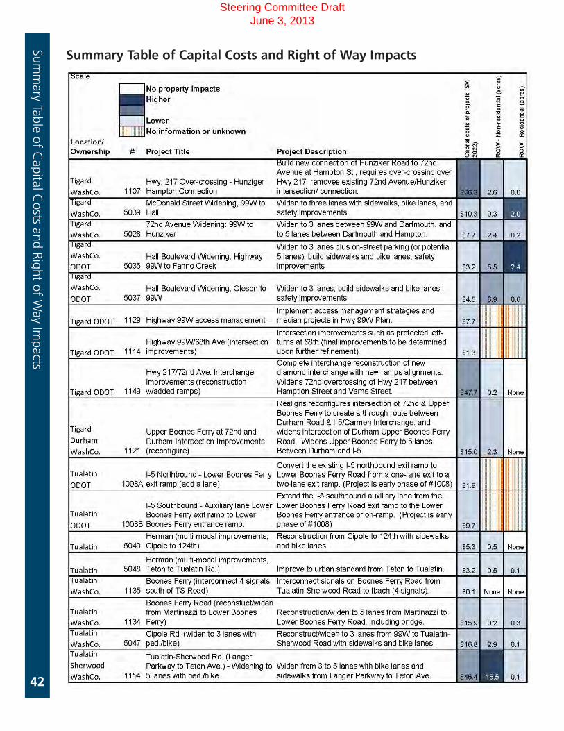
Summary Table of Capital Costs and Right of Way ImpactsSum
mary Tab
le of C
apital C
osts an
d R
igh
t of W
ay Imp
acts
Table 2
Steering Committee Draft June 3, 2013

41
Summary Table of Capital Costs and Right of Way ImpactsSum
mary table of C
apital Costs and Right of W
ay Impacts
Steering Committee Draft June 3, 2013
42
Summary Table of Capital Costs and Right of Way Impacts
Summ
ary Table of Capital C
osts and Right of Way Im
pacts
Steering Committee Draft June 3, 2013

43
Summary Table of Capital Costs and Right of Way ImpactsSum
mary table of C
apital Costs and Right of W
ay Impacts
Steering Committee Draft June 3, 2013