Embed Size (px)
Citation preview
Versão online: http://www.lneg.pt/iedt/unidades/16/paginas/26/30/185 Comunicações Geológicas (2014) 101, Especial II, 1051-1054 IX CNG/2º CoGePLiP, Porto 2014 ISSN: 0873-948X; e-ISSN: 1647-581X
Estimative of sediment yield in mountainous catchments: a pilot study in a meso-scale catchment of the Douro Basin, Northern Portugal Estimativa de transporte de sedimentos em bacias de montanha: um estudo piloto numa sub-bacia de dimensão média da Bacia do Douro, NE de Portugal A. R. Reis1,2*, J. M. M. Lourenço3, A. Parker4, A. Alencoão1,2
© 2014 LNEG – Laboratório Nacional de Geologia e Energia IP
Abstract: This study describes the preliminary results of a GIS-based mass balance model of overland sediment transport in the River Corgo catchment, located in the River Douro basin. The erosion, the first step of sediment transport, was estimated by an empirical model - The Revised Universal Soil Loss Equation (RUSLE). The objective is to construct a GIS based potential soil loss spatial index model and posteriorly estimate the sediment yield for different locations within the catchment. The preliminary results show that about 2% of the study area is classified as highest erosion risk potential, and 22% area is under low to moderate erosion risk; these locate in the west, northwest and southern regions of the study area. The estimated soil losses are related, essentially, with one of the lithologies outcropping in the catchment area (48%). Keywords: Soil erosion, USLE, GIS, Lithology, Sediment. Resumo: O estudo apresentado descreve os resultados preliminares de um modelo de balanço de massa, desenvolvido em ambiente SIG, relativo ao transporte de sedimentos na bacia hidrográfica do rio Corgo, a qual se integra na bacia hidrográfica do rio Douro. A erosão, a primeira fase do transporte de sedimentos, foi estimada pelo método empírico – A Equação Universal de Perda de Solo. O objetivo é desenvolver um modelo do índice espacial de perda do solo, em ambiente SIG, e posteriormente estimar a produção de sedimentos em diversos locais da bacia de drenagem, em função da litologia. Os resultados preliminares mostram que cerca de 2% da área de estudo apresenta risco de erosão potencial elevado, e cerca de 22% da área é classificada com risco de erosão potencial baixo a moderado, estando neste caso as zonas oeste, noroeste e sul da área de estudo. As perdas de solo estimadas estão relacionadas, essencialmente, com uma das litologias aflorantes na área da bacia (48%). Palavras-chave: Erosão do solo, USLE, SIG, Litologia, Sedimentos. 1Department of Geology, University of Trás-os-Montes e Alto Douro (UTAD), Quinta de Prados, 5000-801 Vila Real, Portugal. 2Center for Geophysics from the University of Coimbra, Coimbra, Portugal. 3Center for Geosciences, University of Coimbra, Coimbra, Portugal. 4Soil Research Group, School of Human and Environmental Sciences, University of Reading, Reading, UK. *Corresponding author / Autor correspondente: [email protected]
1. Introduction
Modelling the transport of sediment and adsorbed contaminants within catchments can help to identify possible contaminant sources, as well as to estimate the delivered quantities of eroded material and associated contaminants. The present study considers a meso-scale mountainous rural catchment, in a temperate climate, which integrates the transboundary River Douro Basin, in the northeast of Portugal.
Previous studies performed in this catchment show that, on the one hand, the intrinsic morphological features of this mountainous catchment raise some issues concerning the monitoring in situ of transported sediments: (a) the low mass yield of suspended sediment from river water, under low-flow conditions; (b) the maintenance of the sediment sampler's devices in the streams, in periods of high-flow or storm events. On the other hand, a geochemical survey on oxic fluvial sediments of the river network shows considerable contents of metals associated to the finer particles (< 63 µm). The results on the study of the sediment properties indicate that these are essentially detrital in origin, derived from soils and weathering products. Moreover, taking into account the hydrological pattern of the catchment, the seasonal and spatial variability of metal contents associated to the sediments suggests that the control of metal in the sediments by their mineralogical, geochemical and physical properties is governed primarily at the level of the basin soils system, especially in the Wet Period, when the sediments are frequently remobilised (Reis, 2010). Although the soil particles are a common pathway of transport and entrance of metals in the fluvial network by runoff derived erosion, this mechanism is naturally more marked in mountainous catchments.
The aim of this study is to develop, in a first stage, a GIS based potential soil loss spatial index model and posteriorly estimate the sediment yield from different locations within the catchment. The final objective is to
Artigo Curto Short Article
1052 A. R. Reis et al. / Comunicações Geológicas (2014) 101, Especial II, 1051-1054
combine data on rates of soil erosion, and inherent sediment production, and sediment quality (related, in particular, with lithology and land use) transported in the drainage network. Hence, it is described the preliminary results related with the assessment of the annual soil erosion vulnerability of the studied catchment.
2. Study area
The study area is located in the transboundary River Douro basin (northern Portugal); it comprises the major part of the River Corgo fluvial network to the gauge station Ermida, which drains a meso-scale rural catchment with an area of 295 km2, in a temperate climate. The land use is mainly forest and agriculture, with scattered urban settlements. The industrial activity is scarce.
The geology comprises crystalline rocks: in the southern part Paleozoic metasediments outcrop, which are composed essentially of schists, greywackes and quartzites; in the northern part of the basin, granites intruded the older metamorphic rocks. Locally the crystalline rocks are covered by Quaternary deposits, with major expression in two agricultural valleys: Campeã valley in the southwest area, and Vila Pouca de Aguiar valley, in the northern area. The altitudes in the basin vary between 300-1400m.
3. Methodology
The erosion (the first step of sediment transport), was estimated by an empirical model - The Universal Soil Loss Equation (USLE) - developed by Wischmeier & Smith (1978). A comprehensive methodology that integrates this Equation and Geographic Information Systems (GIS) techniques was adopted.
The R factor (rainfall – erosivity index) was obtained applying the model proposed by Ferro et al. (1991), adapted to the portuguese continental territory by Brandão et al. (2001), using the values of 24 udometric stations. The K factor (soil erodibility index) was derived from the Soil Map of Trás-os-Montes (Agroconsultores, 1991), applying the values proposed by Pimenta (1998). The combined determination of LS factor (slope length and stepness factor) was calculated from the digital terrain model (DEM) of the area under study, by applying the methodology proposed by Moore & Burche (1986a, b); to avoid the influence of the areas corresponding to the bottom of the valleys, where the accumulated flows are higher and do not translate any relationship with the lengths of slopes, there was attributed the value corresponding to the maximum length of the slopes in the DEM (750 m/25 m). The C factor (land cover management index) was calculated from the Corine Land Cover 2006 coverage and land use map published for continental Portugal, at scale 1:100.000 (Caetano et al., 2009), assigning, to the different classes, the values recommended by Pimenta (1998). The P (conservation practice index) values resulted from the adaptation of the values proposed by Wischmeier & Smith (1978) and Tomás (1993) to the agricultural areas of the Corine Land Cover 2006 map
(Caetano et al., 2009), classified by slopes (from the DEM) and according to the configuration of agricultural crops, obtained by analysis of aerial photographs from 2004 to 2006.
4. Results and discussion
The preliminary results indicate that the model is in accordance with the knowledge of the study area, and can be used as an initial indicator of areas of potential sediment source. So, the results show that potential loss is typically higher along the areas where the tributaries are deeply incised and bordered by steeper slopes, with locally extreme values.
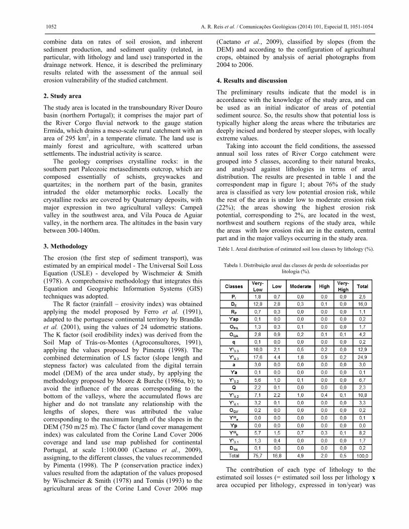
Taking into account the field conditions, the assessed annual soil loss rates of River Corgo catchment were grouped into 5 classes, according to their natural breaks, and analysed against lithologies in terms of areal distribution. The results are presented in table 1 and the correspondent map in figure 1; about 76% of the study area is classified as very low potential erosion risk, while the rest of the area is under low to moderate erosion risk (22%); the areas showing the highest erosion risk potential, corresponding to 2%, are located in the west, northwest and southern regions of the study area, while the areas with low erosion risk are in the eastern, central part and in the major valleys occurring in the study area. Table 1. Areal distribution of estimated soil loss classes by lithology (%).
Tabela 1. Distribuição areal das classes de perda de soloestiadas por
litologia (%).
The contribution of each type of lithology to the
estimated soil losses (= estimated soil loss per lithology x area occupied per lithology, expressed in ton/year) was

Sediment yield in mountainous catchments 1053
also analysed (Table 2 and Fig. 2). The results suggest that almost half of the estimated soil losses are related to one type of outcropping lithologies. The lithology ϒI4.3 (medium-to-coarse-grained, with scarce phenocrysts, two-mica granite – patch 123) contributes 48% of the estimated soil loss, although the respective occupied area is only 12% of the study area. Furthermore, the assemblage of the lithological units ϒI4.3 (medium-to-coarse-grained, with scarce phenocrysts, two-mica granite – patch 123), DE (Desejosa Formation – patch 119) and ϒIIIb (coarse-to-medium-grained porphyritic biotite granite – patch 152), which occur spatially in contiguous areas in the south-western area of the catchment, contribute 69.7% of the estimated soil loss. An interconnected drainage network drains these lithologies.
Fig 1. Estimated soil loss map of River Corgo catchment. Fig 1. Mapa de perda de solo estimada para a bacia hidrográfica do Rio Corgo.
In the central and north areas of the Corgo basin, the contribution of each type of lithology to the estimated soil losses is more uniformly distributed by lithology, though the lithology ϒIIIb (coarse-to-medium-grained porphyritic biotite granite – patch 251), which also outcrops in the north limit area of the basin, shows slightly higher values, in relation to the surrounding lithologies.
The results of this study, obtained by the application of USLE model in a GIS environment, allowed to identify the spatial patterns of the soil erosion risk in a mountainous rural catchment, developed in crystalline rocks. The model outcomes need to be validated and further investigation is
in development. This includes field work with the aim of assess sediment volumes transported in specific sites of the drainage network, and its relation with different drained lithologies, to provide quantitative predictions of river sediment yield. The analysis of potential/possible relationships between the mineralogical and chemical characteristics of the oxic sediments, and transport of associated contaminants will also be considered.
Table 2. Estimated soil losses per lithological patch.
Tabela 2. Perdas de solo estimadas por mancha litológica.
Fig 2. Estimated soil loss per lithological patch for the Corgo River catchment. Fig 2. Perda de solo estimada por mancha litológica para a bacia hidrográfica do Rio Corgo.
1054 A. R. Reis et al. / Comunicações Geológicas (2014) 101, Especial II, 1051-1054
References Agroconsultores, Coba, 1991. Carta de solos, carta do uso actual da
terra e carta de aptidão da terra do nordeste de Portugal. Relatório técnico. Universidade de Trás-os-Montes e Alto Douro, 311 p.
Brandão, C., Rodrigues, R., Costa, J.P., 2001. Análise de fenómenos extremos, precipitações intensas em Portugal continental. Direcção dos Serviços de Recursos Hídricos, Instituto da Água. Lisboa. 57 p.
Caetano, M., Nunes, V., Nunes, A., 2009. CORINE Land Cover 2006 for Continental Portugal. Technical Report. Instituto Geográfico Português.
Ferro, V., Giordano, G., Iovino, M., 1991. Isoerosivity and erosion risk map for Sicily. Hydrological Sciences Journal, 36(6), 549-564.
Moore, I.D., Burch, G.J., 1986a. Physical basis of the length slope factor in the Universal Soil Loss Equation. Soil Science Society of America, 50(5), 1294-1298.
Moore, I.D., Burch, G.J., 1986b. Modeling erosion and deposition. Topographic effects. Transactions of American Society of Agriculture Engineering, 29(6), 1624-1630.
Pimenta, M.T., 1998. Directrizes para a aplicação da equação universal de perda dos solos em SIG: factor de cultura C e factor de erodibilidade do Solo K. Direcção de Serviços de Recursos Hídricos, Instituto da Água. Lisboa. 12 p.
Reis, A.R., 2010. Occurrence and mobilisation of non-organic micro-pollutants in mountainous riverine systems. PhD Thesis, University of Trás-os-Montes e Alto Douro (unpublished), 453 p.
Tomás, P., 1993. Erosão hídrica do solo em pequenas bacias hidrográficas: Aplicação da equação universal de perda de solo. Lisboa.
Wischmeier, W., Smith, D., 1978. Predicting rainfall erosion losses: a Guide to conservation planning. Department of Agriculture Handbook, N.º 537, USDA, Washington.