Embed Size (px)
Citation preview
ESA Integrated Applications Programme (IAP)
Stimulating User Driven Projects
TSB, BNSC & ESA Forum on Transport, Safety and Energy challenges - New Opportunities and Call for Projects Proposals
Nov. 12th 2009, Harwell
A. Ginati, European Space Agency (ESA)
2
•• IntroductionIntroduction•• ESA & IAP ESA & IAP ProgrammeProgramme Objectives Objectives •• Demonstration Projects, Illustrative ExamplesDemonstration Projects, Illustrative Examples•• FlySafeFlySafe & European AIS Mission& European AIS Mission•• ConclusionConclusion
Table of content Table of content
3
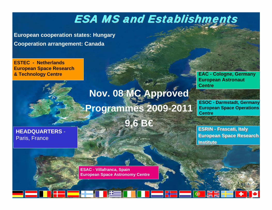
ESA MS and EstablishmentsESA MS and Establishments
ESTEC - NetherlandsEuropean Space Research& Technology Centre EAC - Cologne, Germany
European AstronautCentre
ESOC - Darmstadt, GermanyEuropean Space Operations Centre
HEADQUARTERS -Paris, France
European cooperation states: HungaryCooperation arrangement: Canada
ESRIN - Frascati, ItalyEuropean Space ResearchInstitute
ESRIN - Frascati, ItalyEuropean Space ResearchInstitute
Nov. 08 MC Approved Programmes 2009-2011
9,6 B€
ESAC - Villafranca, SpainEuropean Space Astronomy Centre
4
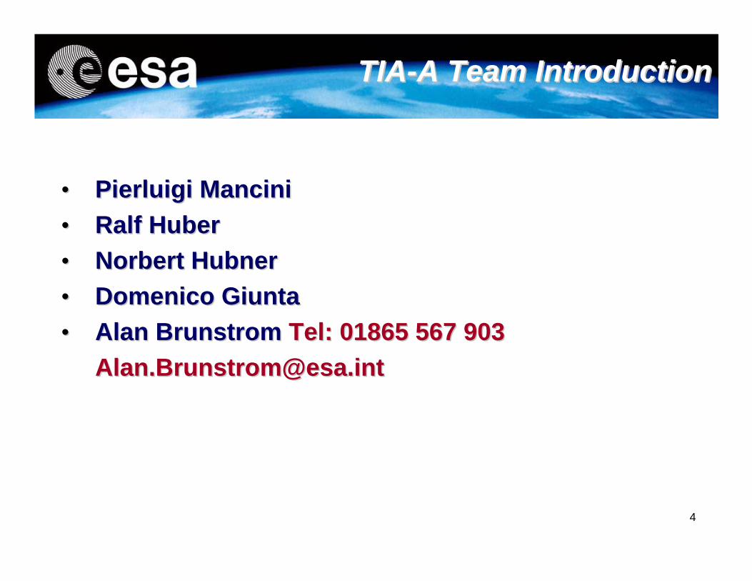
•• PierluigiPierluigi Mancini Mancini •• Ralf HuberRalf Huber•• Norbert Norbert HubnerHubner•• DomenicoDomenico GiuntaGiunta•• Alan Alan BrunstromBrunstrom Tel: 01865 567 903 Tel: 01865 567 903
[email protected]@esa.int
TIATIA--A Team IntroductionA Team Introduction
5
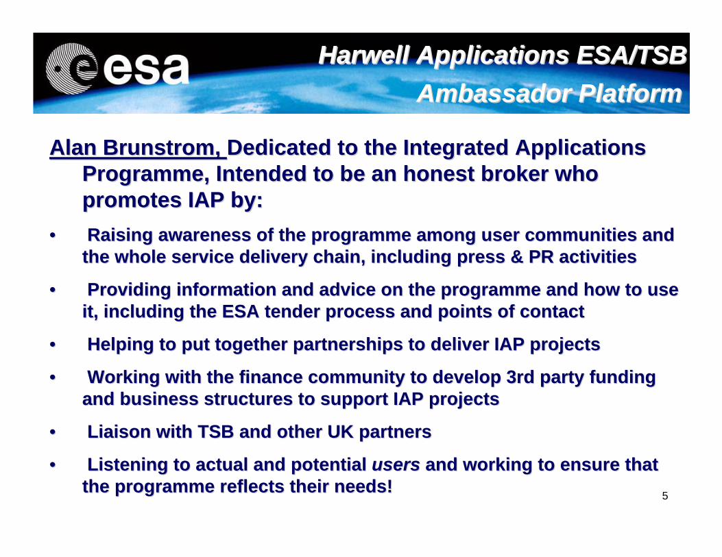
Alan Alan BrunstromBrunstrom, , Dedicated to the Integrated Applications Dedicated to the Integrated Applications Programme, Intended to be an honest broker who Programme, Intended to be an honest broker who promotes IAP by:promotes IAP by:
•• Raising awareness of the programme among user communities and Raising awareness of the programme among user communities and the whole service delivery chain, including press & PR activitiethe whole service delivery chain, including press & PR activitiess
•• Providing information and advice on the programme and how to usProviding information and advice on the programme and how to use e it, including the ESA tender process and points of contactit, including the ESA tender process and points of contact
•• Helping to put together partnerships to deliver IAP projects Helping to put together partnerships to deliver IAP projects
•• Working with the finance community to develop 3rd party fundingWorking with the finance community to develop 3rd party fundingand business structures to support IAP projectsand business structures to support IAP projects
•• Liaison with TSB and other UK partnersLiaison with TSB and other UK partners
•• Listening to actual and potential Listening to actual and potential usersusers and working to ensure that and working to ensure that the programme reflects their needs!the programme reflects their needs!
Harwell Applications ESA/TSB Harwell Applications ESA/TSB Ambassador PlatformAmbassador Platform
6
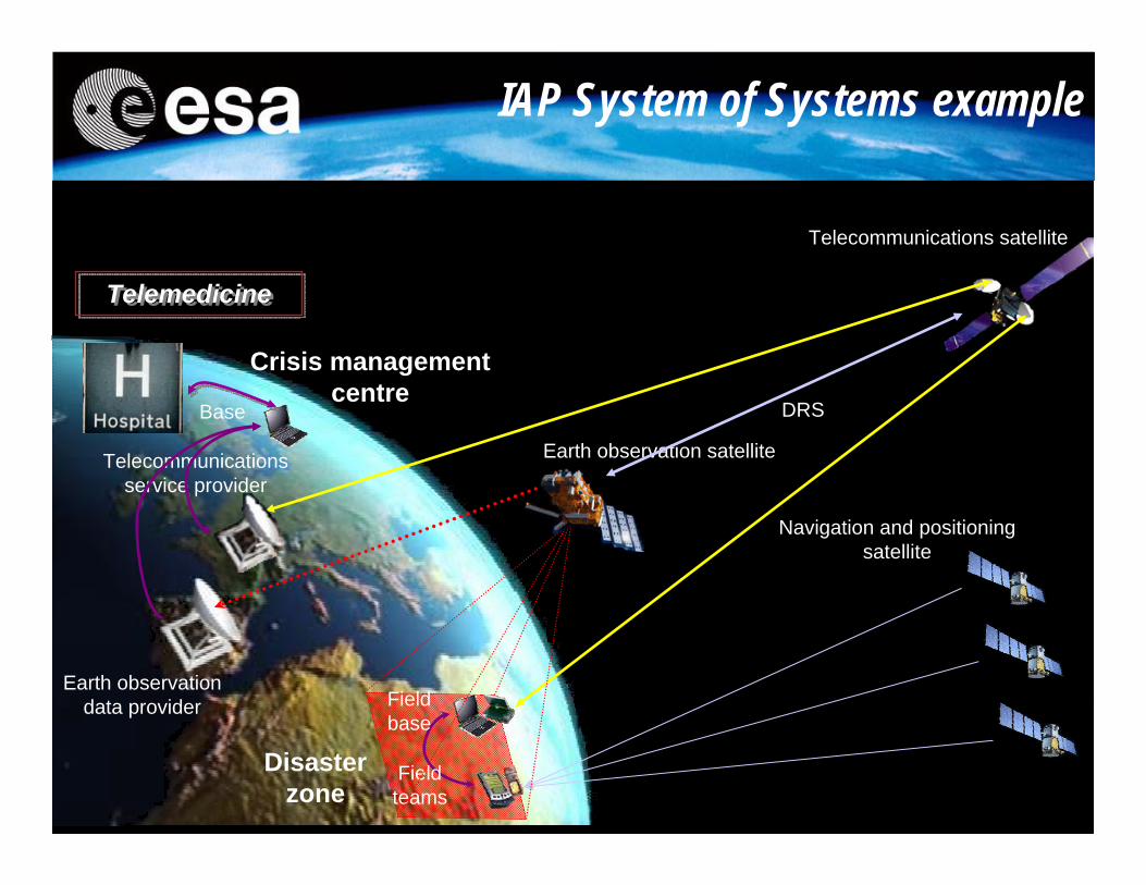
IAP System of Systems example
Disaster zone
Navigation and positioning satellite
Field teams
Field base
Telecommunications satellite
Telecommunications service provider
Base
Crisis management centre
Earth observation satellite
Earth observation data provider
DRS
TelemedicineTelemedicine
7
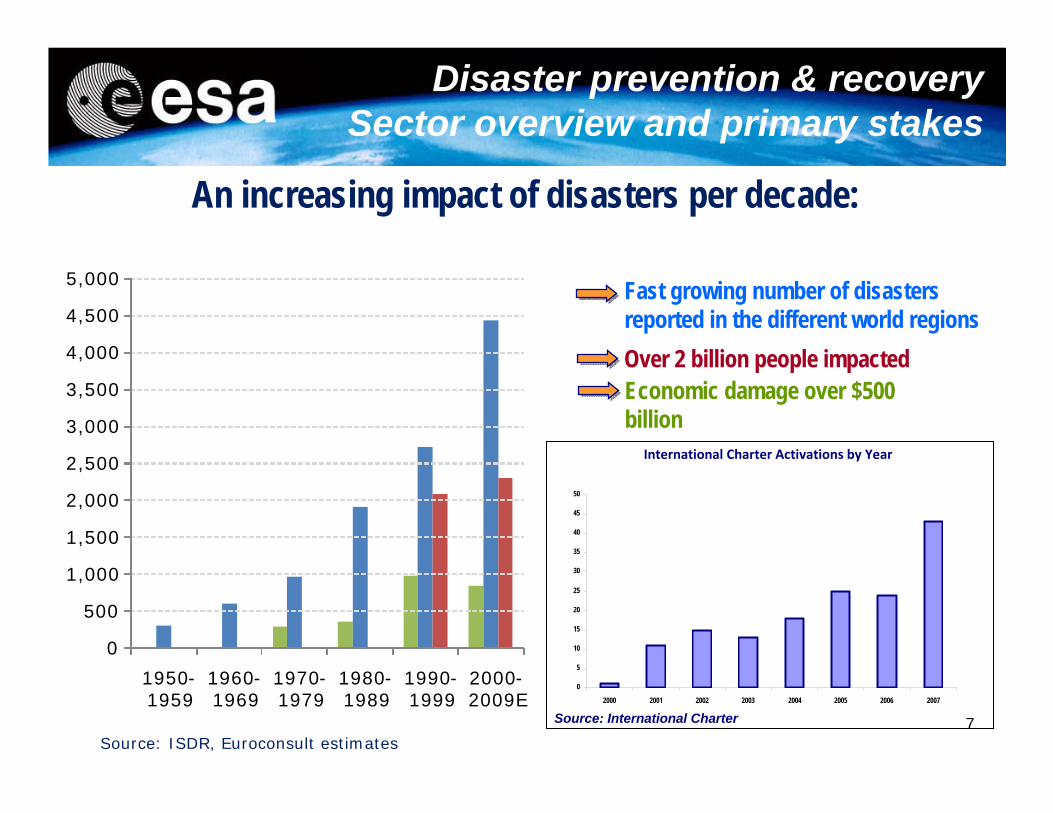
International Charter Activations by Year
Source: International Charter
0
5
10
15
20
25
30
35
40
45
50
2000 2001 2002 2003 2004 2005 2006 2007
An increasing impact of disasters per decade:
Source: ISDR, Euroconsult estimates
Disaster prevention & recoverySector overview and primary stakes
Economic damage over $500 billion
Fast growing number of disasters reported in the different world regionsOver 2 billion people impacted
0
500
1,000
1,500
2,000
2,500
3,000
3,500
4,000
4,500
5,000
1950-1959
1960-1969
1970-1979
1980-1989
1990-1999
2000-2009E
8
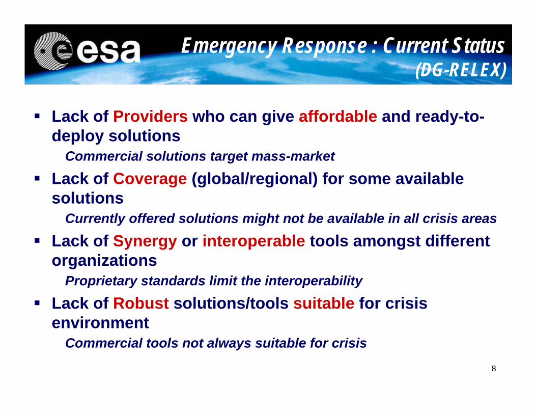
Lack of Providers who can give affordable and ready-to-deploy solutions
Commercial solutions target mass-market
Lack of Coverage (global/regional) for some available solutions
Currently offered solutions might not be available in all crisis areas
Lack of Synergy or interoperable tools amongst different organizations
Proprietary standards limit the interoperability
Lack of Robust solutions/tools suitable for crisis environment
Commercial tools not always suitable for crisis
Emergency Response : Current Status(DG-RELEX)
9
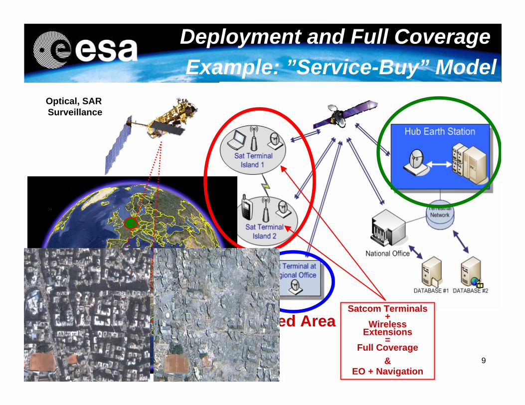
Affected AreaSatcom Terminals
+Wireless
Extensions=
Full Coverage&
EO + Navigation
Optical, SAR Surveillance
Deployment and Full Coverage Example: ”Service-Buy” Model
10
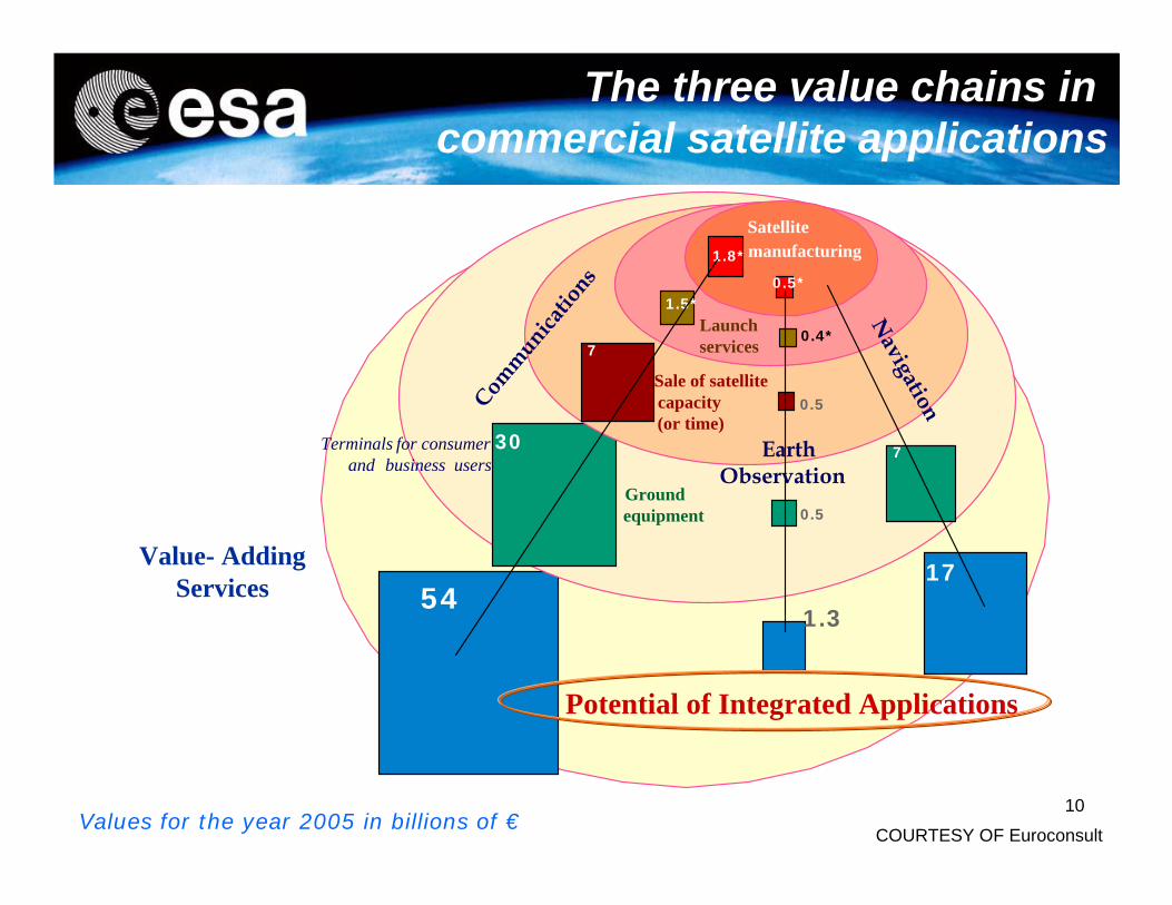
5417
1.3
Value- Adding Services
Groundequipment
30 7
0.5
Terminals for consumer and business users
Sale of satellite capacity(or time)
7
0.5
Launchservices
1.5*
0.4*
Satellitemanufacturing1.8*
0.5*
Communications
EarthObservation
Navigation
COURTESY OF EuroconsultValues for the year 2005 in billions of €
Potential of Integrated Applications
The three value chains in commercial satellite applications
11
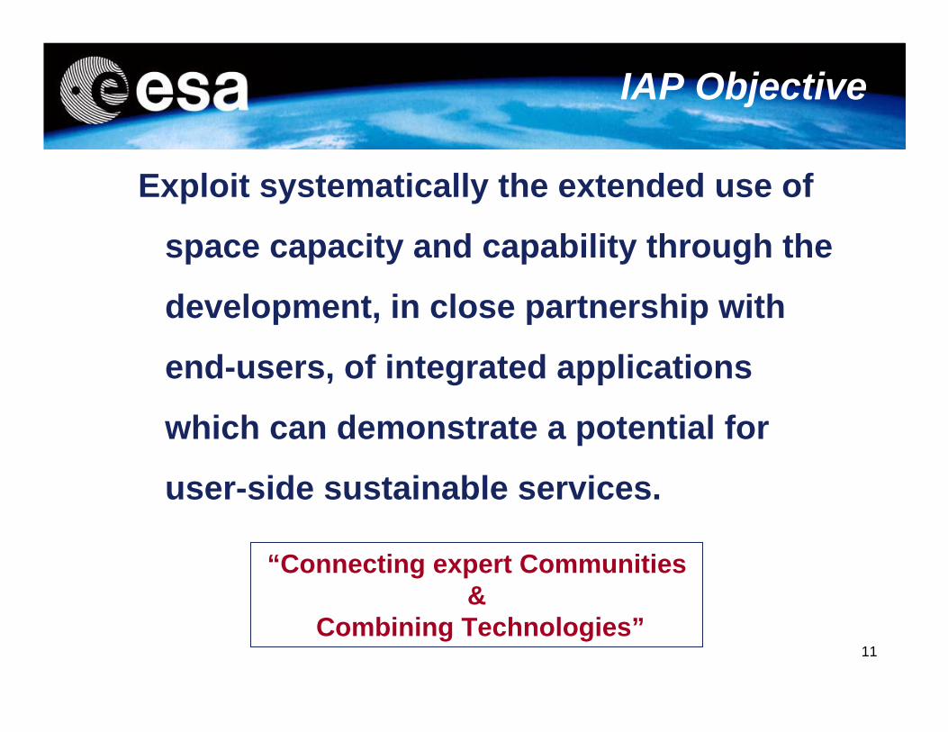
IAP Objective
“Connecting expert Communities &
Combining Technologies”
Exploit systematically the extended use of
space capacity and capability through the
development, in close partnership with
end-users, of integrated applications
which can demonstrate a potential for
user-side sustainable services.
12
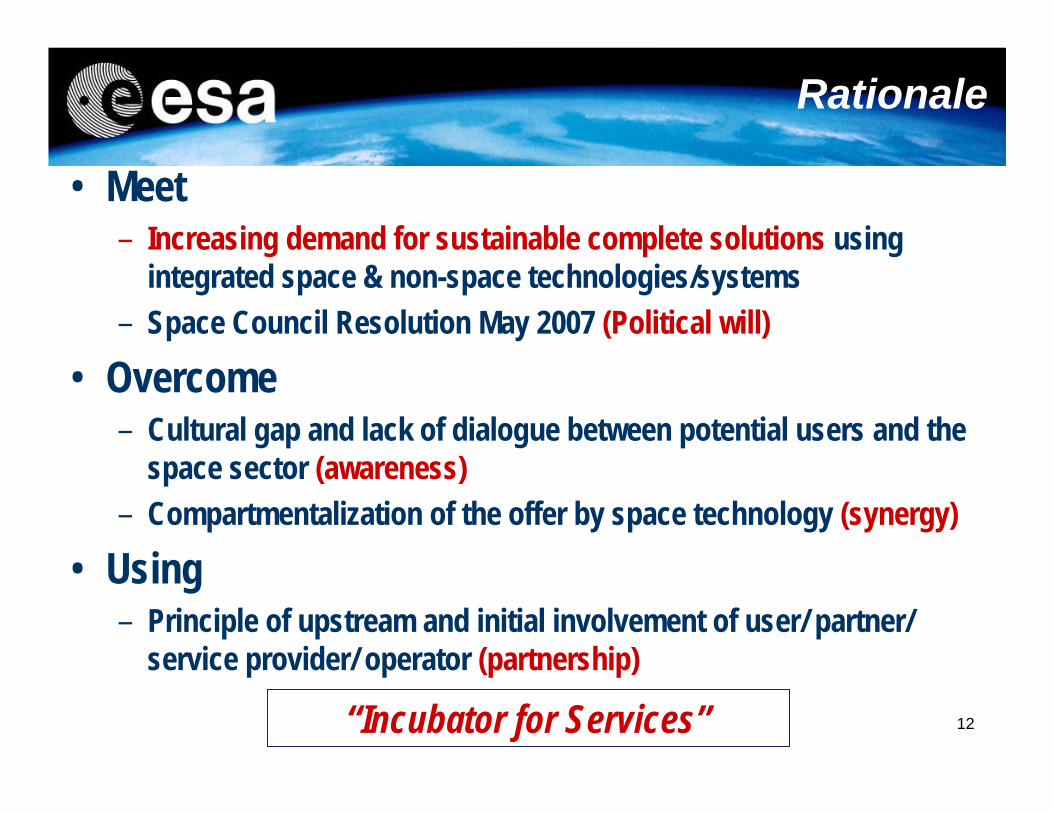
Rationale
• Meet– Increasing demand for sustainable complete solutions using
integrated space & non-space technologies/systems– Space Council Resolution May 2007 (Political will)
• Overcome – Cultural gap and lack of dialogue between potential users and the
space sector (awareness)– Compartmentalization of the offer by space technology (synergy)
• Using – Principle of upstream and initial involvement of user/ partner/
service provider/ operator (partnership)
“Incubator for Services”
13
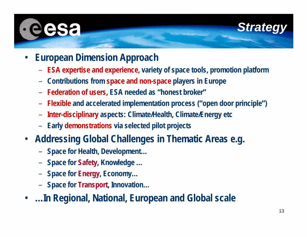
Strategy
• European Dimension Approach– ESA expertise and experience, variety of space tools, promotion platform – Contributions from space and non-space players in Europe– Federation of users, ESA needed as “honest broker”– Flexible and accelerated implementation process (“open door principle”)– Inter-disciplinary aspects: Climate/Health, Climate/Energy etc– Early demonstrations via selected pilot projects
• Addressing Global Challenges in Thematic Areas e.g. – Space for Health, Development…– Space for Safety, Knowledge …– Space for Energy, Economy…– Space for Transport, Innovation…
• …In Regional, National, European and Global scale
14
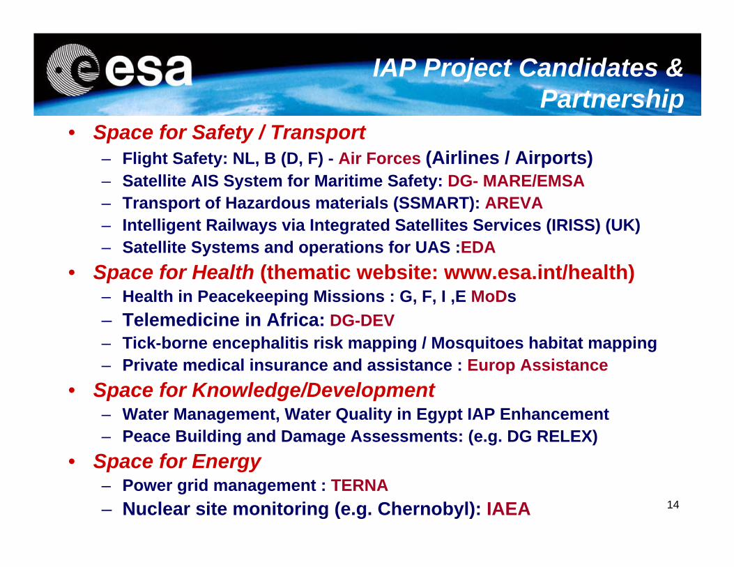
IAP Project Candidates & Partnership
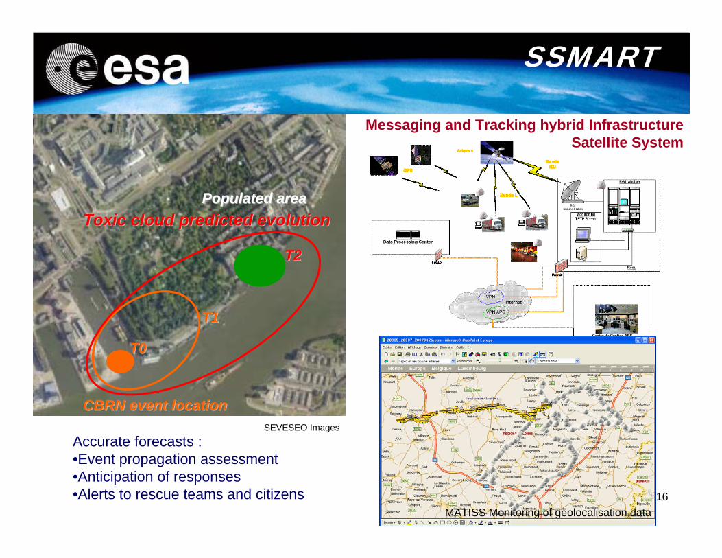
• Space for Safety / Transport– Flight Safety: NL, B (D, F) - Air Forces (Airlines / Airports)– Satellite AIS System for Maritime Safety: DG- MARE/EMSA– Transport of Hazardous materials (SSMART): AREVA– Intelligent Railways via Integrated Satellites Services (IRISS) (UK)– Satellite Systems and operations for UAS :EDA
• Space for Health (thematic website: www.esa.int/health)– Health in Peacekeeping Missions : G, F, I ,E MoDs– Telemedicine in Africa: DG-DEV– Tick-borne encephalitis risk mapping / Mosquitoes habitat mapping– Private medical insurance and assistance : Europ Assistance
• Space for Knowledge/Development– Water Management, Water Quality in Egypt IAP Enhancement– Peace Building and Damage Assessments: (e.g. DG RELEX)
• Space for Energy– Power grid management : TERNA– Nuclear site monitoring (e.g. Chernobyl): IAEA
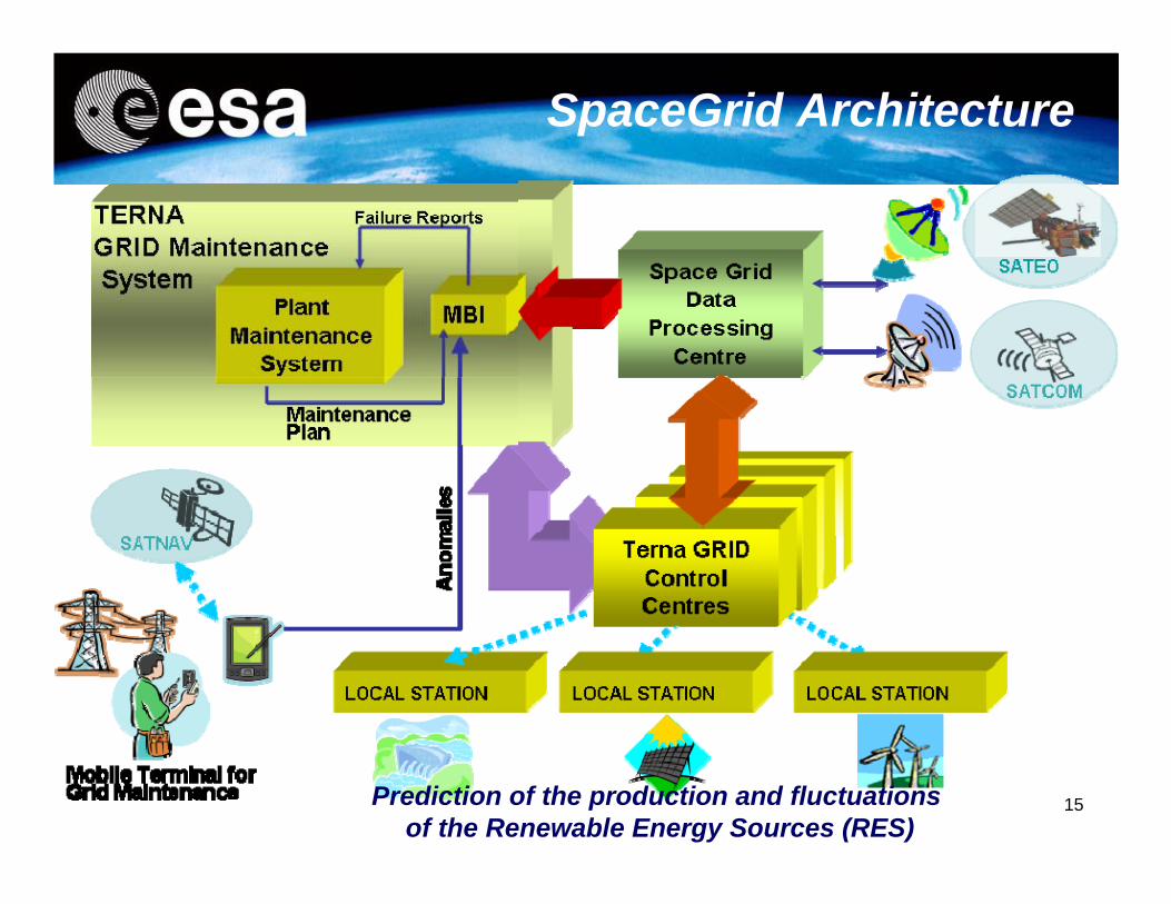
15Prediction of the production and fluctuations of the Renewable Energy Sources (RES)
SpaceGrid Architecture
16
SEVESEO Images
MATISS Monitoring of geolocalisation data
Messaging and Tracking hybrid Infrastructure Satellite System
SSMART
Toxic cloud predicted evolutionToxic cloud predicted evolution
T0T0
T2T2
T1T1
Populated areaPopulated area
CBRN event locationCBRN event location
Accurate forecasts : •Event propagation assessment•Anticipation of responses•Alerts to rescue teams and citizens
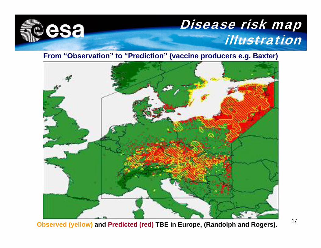
17Observed (yellow) and Predicted (red) TBE in Europe, (Randolph and Rogers).
From “Observation” to “Prediction” (vaccine producers e.g. Baxter)
Disease risk map illustration
18
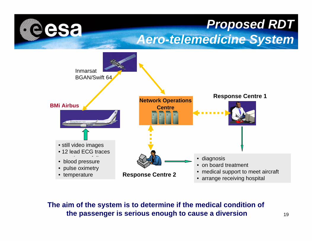
Management of Medical Emergency for commercial aviation: the issue
• In one hand, every year in all world airlines between 700 and 1000 hundred people died during long duration flights (more than 6 hours) due to medical reasons; each day between 1 and 1.5 planes are landing in emergency conditions for medical reasons the statistic data on these landings showed that 45% can be avoid if a single electrocardiogram could be transmitted from the plane to an emergency medical department in an hospital; the cost of such re-routings is about 80K€.
• In the other hand , the travel duration are more and more long i.e. the next A380 planes (more than 15 hours non stop); the number of passengers will increase with the new capacities of the planes
19
Proposed RDT Aero-telemedicine System
Network Operations Centre
Response Centre 1
Response Centre 2
• still video images• 12 lead ECG traces• continuous full duplex voice
BMi Airbus
InmarsatBGAN/Swift 64
• diagnosis• on board treatment• medical support to meet aircraft• arrange receiving hospital
The aim of the system is to determine if the medical condition of the passenger is serious enough to cause a diversion
• blood pressure• pulse oximetry• temperature
20
0
10,000
20,000
30,000
40,000
50,000
60,000
70,000
80,000
90,000
1991 1995 1999 2003 2007
Source: UN
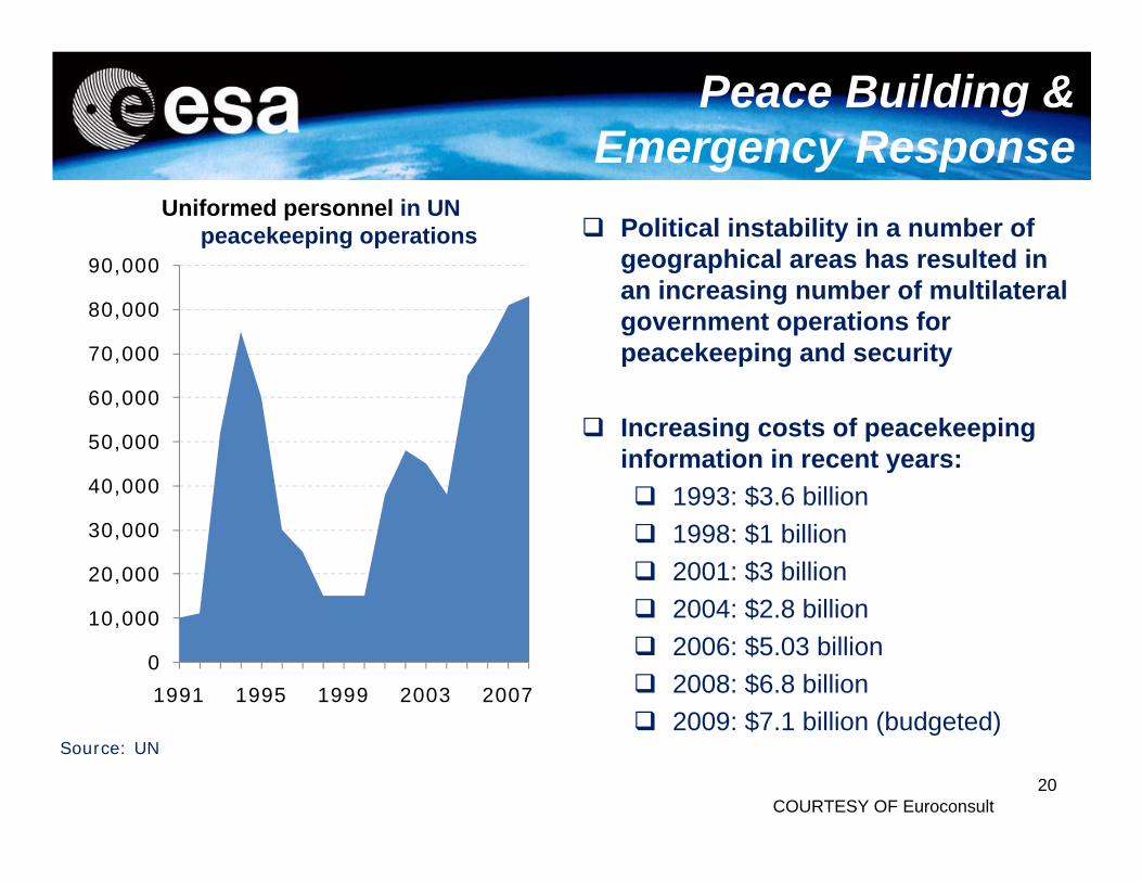
Uniformed personnel in UN peacekeeping operations Political instability in a number of
geographical areas has resulted in an increasing number of multilateral government operations for peacekeeping and security
Increasing costs of peacekeeping information in recent years: 1993: $3.6 billion 1998: $1 billion 2001: $3 billion 2004: $2.8 billion 2006: $5.03 billion 2008: $6.8 billion 2009: $7.1 billion (budgeted)
COURTESY OF Euroconsult
Peace Building & Emergency Response
21
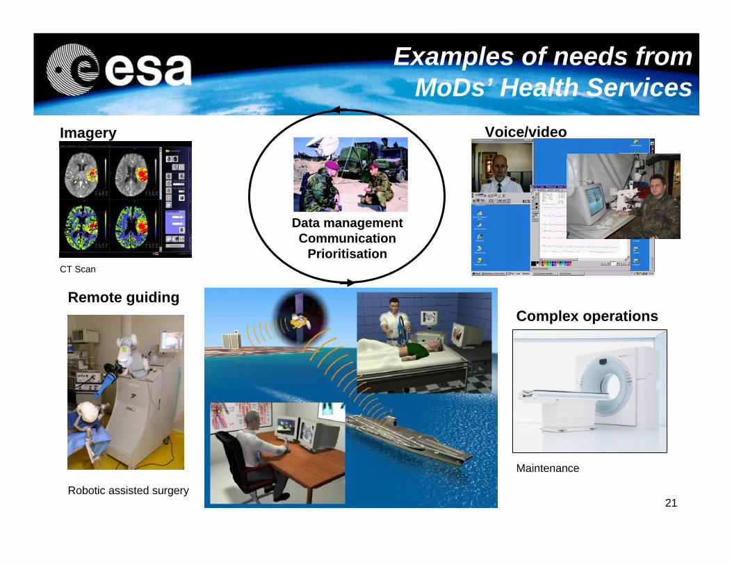
Examples of needs from MoDs’ Health Services
Imagery
CT Scan
Remote guiding
Robotic assisted surgery
Voice/video
Patient/expert
Data managementCommunication
Prioritisation
Complex operations
Maintenance
22
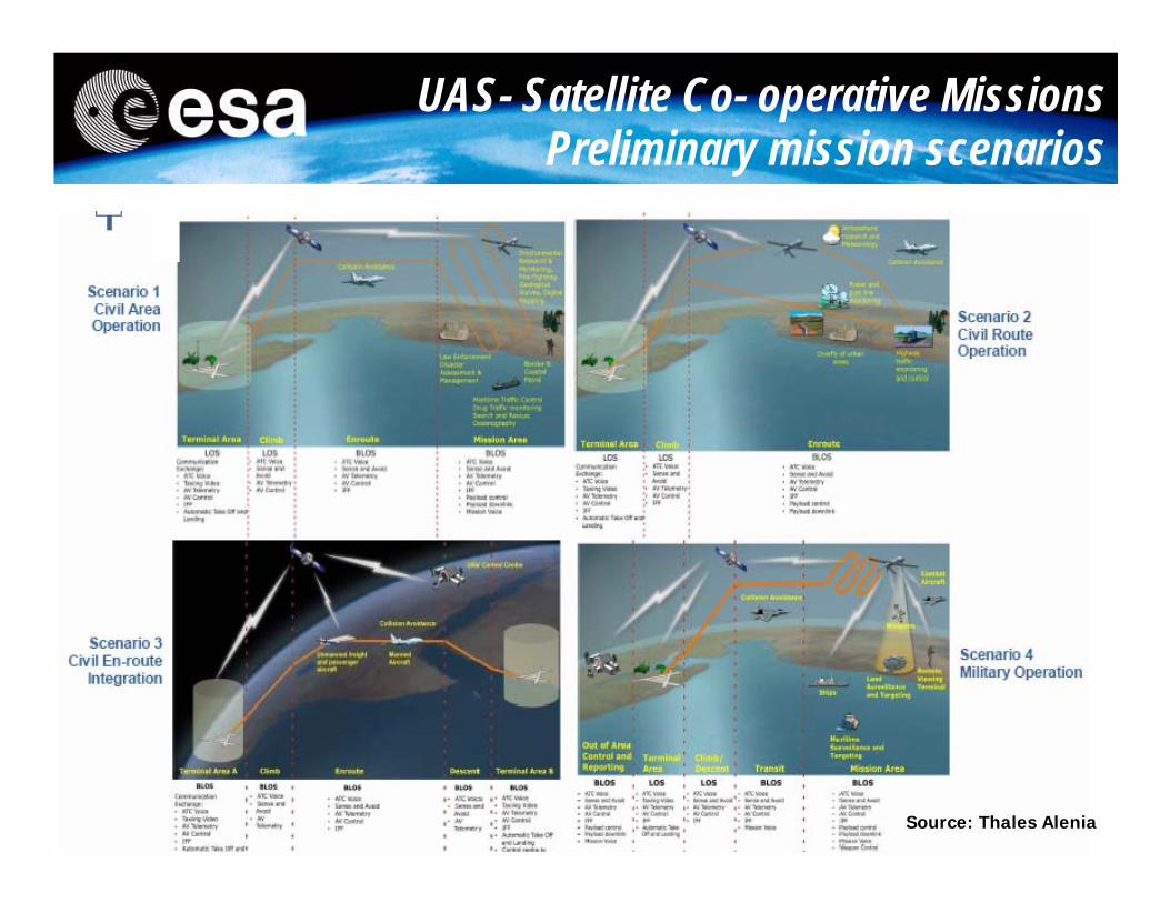
UAS- Satellite Co- operative Missions Preliminary mission scenarios
Source: Thales Alenia
23
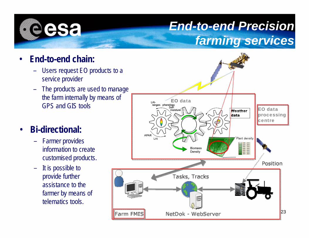
End-to-end Precision farming services
EO data
EO data processing centre
• End-to-end chain:– Users request EO products to a
service provider– The products are used to manage
the farm internally by means of GPS and GIS tools
• Bi-directional:– Farmer provides
information to create customised products.
– It is possible to provide further assistance to the farmer by means of telematics tools.
24
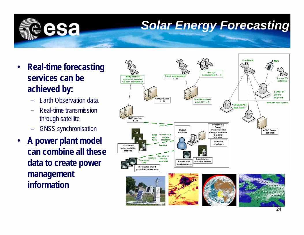
Solar Energy Forecasting
• Real-time forecasting services can be achieved by:
– Earth Observation data.– Real-time transmission
through satellite– GNSS synchronisation
• A power plant model can combine all these data to create power management information
25
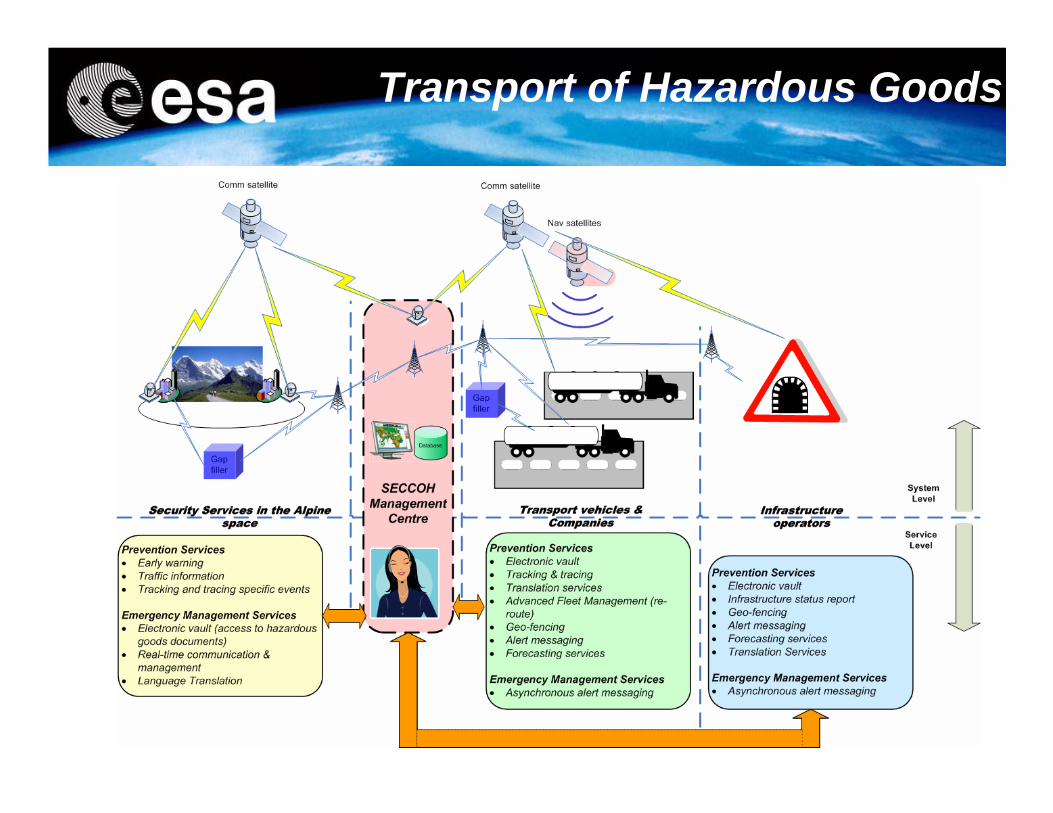
Transport of Hazardous Goods
26
IAP FlySafe Project
27
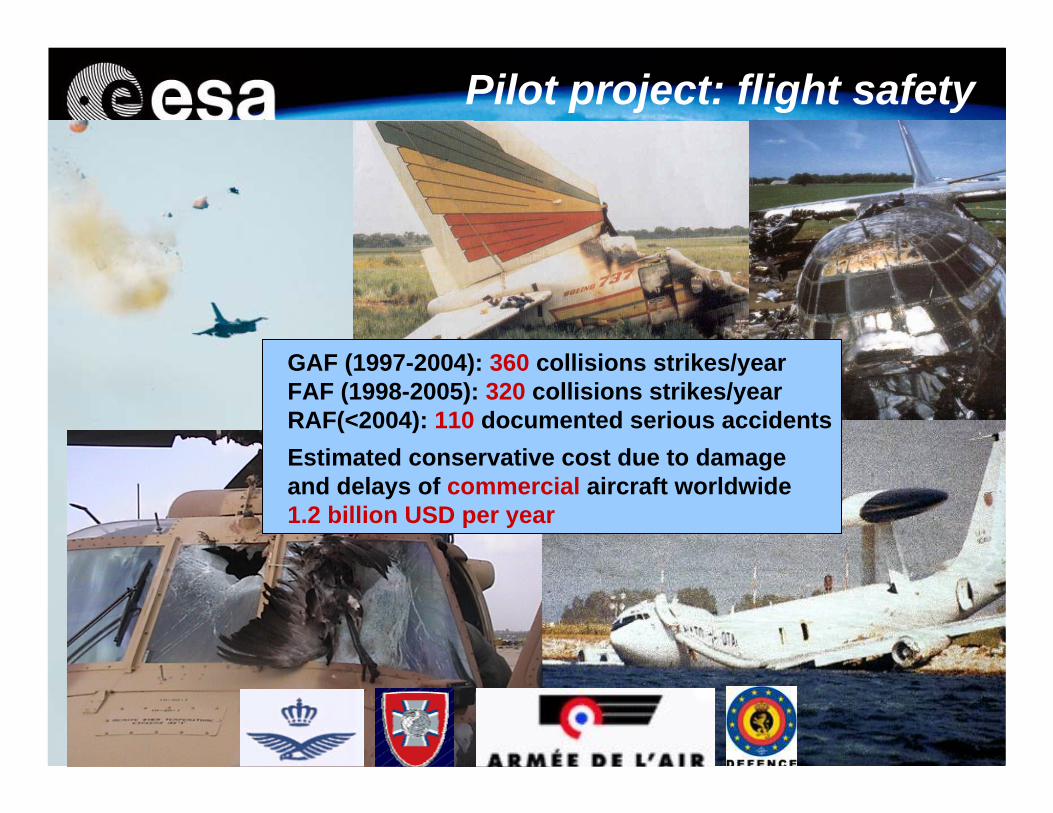
GAF (1997-2004): 360 collisions strikes/yearFAF (1998-2005): 320 collisions strikes/yearRAF(<2004): 110 documented serious accidentsEstimated conservative cost due to damage and delays of commercial aircraft worldwide 1.2 billion USD per year
Pilot project: flight safety
28
29
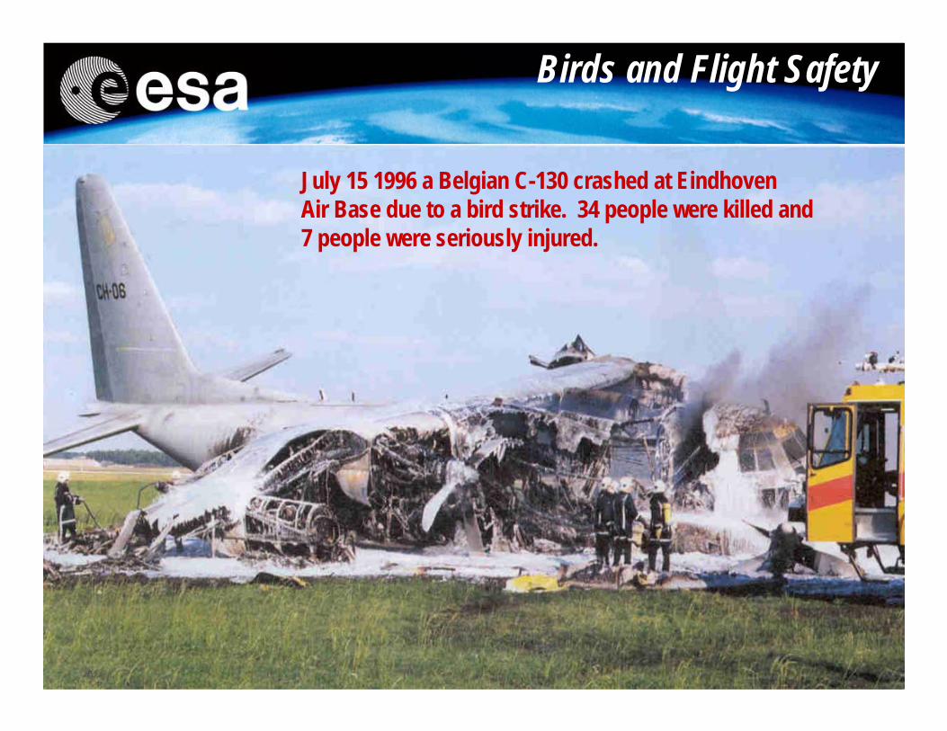
Birds and Flight Safety
July 15 1996 a Belgian C-130 crashed at Eindhoven Air Base due to a bird strike. 34 people were killed and 7 people were seriously injured.
30
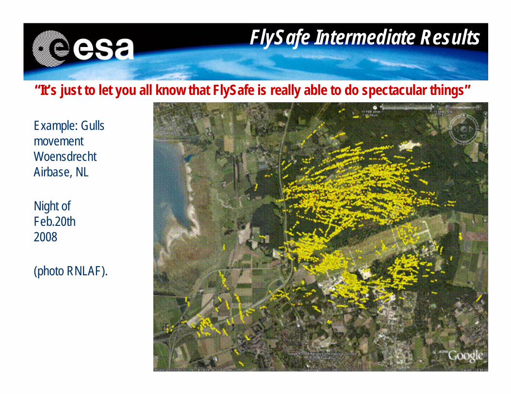
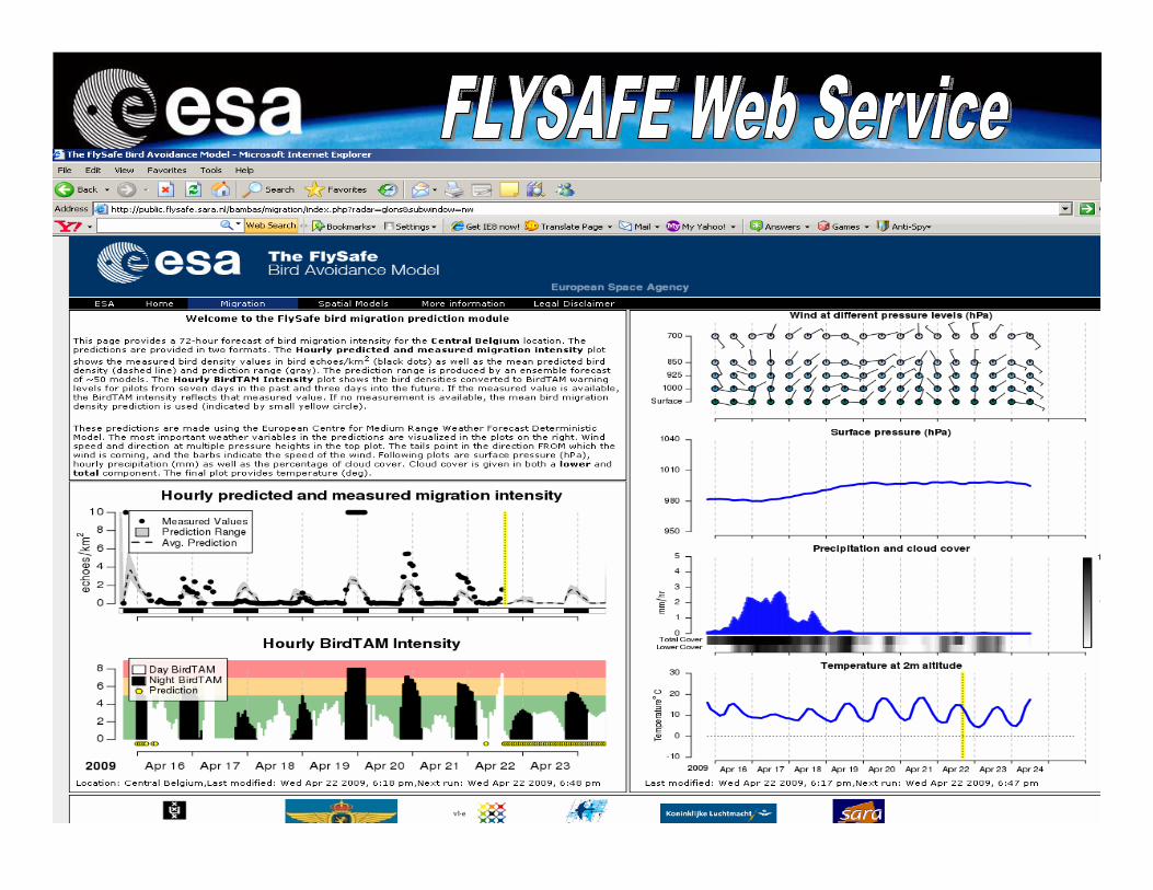
FlySafe Intermediate Results
Example: Gulls movement WoensdrechtAirbase, NL
Night of Feb.20th2008
(photo RNLAF).
“It’s just to let you all know that FlySafe is really able to do spectacular things”
- EO data & meteorology
- Long Range MilitarySurveillance Radars(150km radius,migration)
- Weather radars for migration (altitude distributions migration)
- Short Range Specialized Radarson air fields (local bird behaviour 5-10 km range)
-Individual birdsTracking (species specific information)
FlySafe elements and Sensors
32
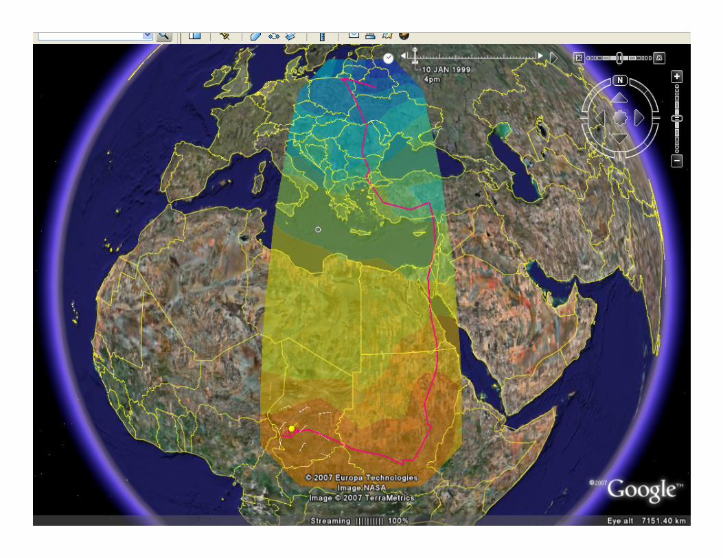
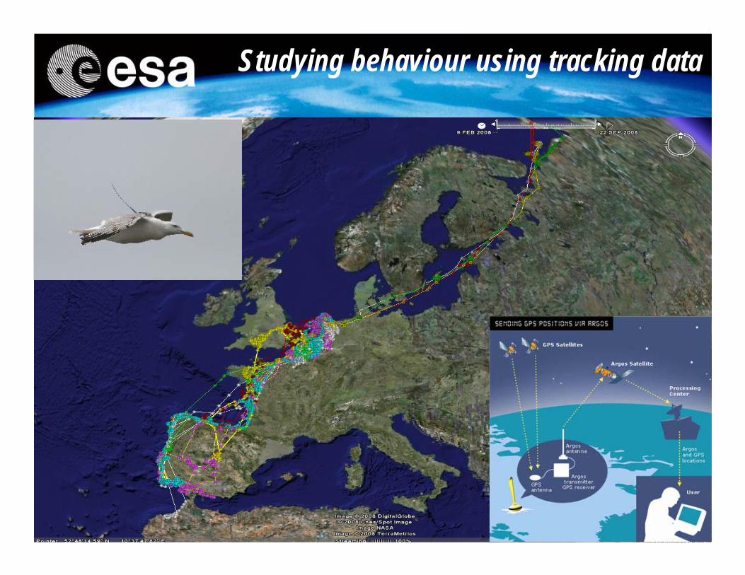
Studying behaviour using tracking data
33
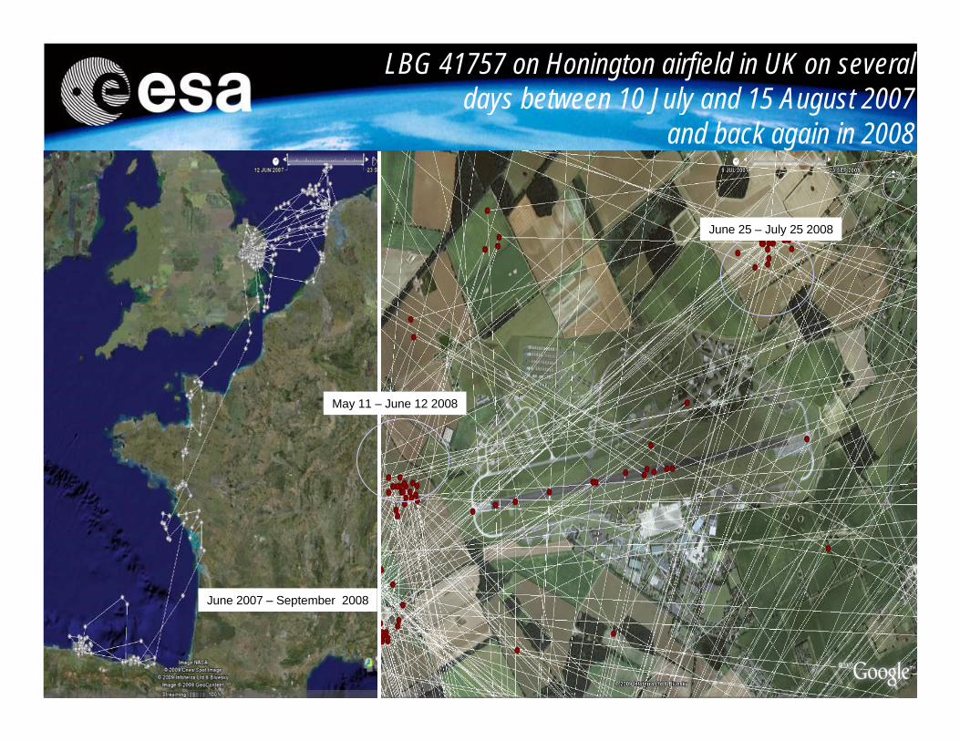
LBG 41757 on Honington airfield in UK on several days between 10 July and 15 August 2007
and back again in 2008
June 25 – July 25 2008
May 11 – June 12 2008
June 2007 – September 2008
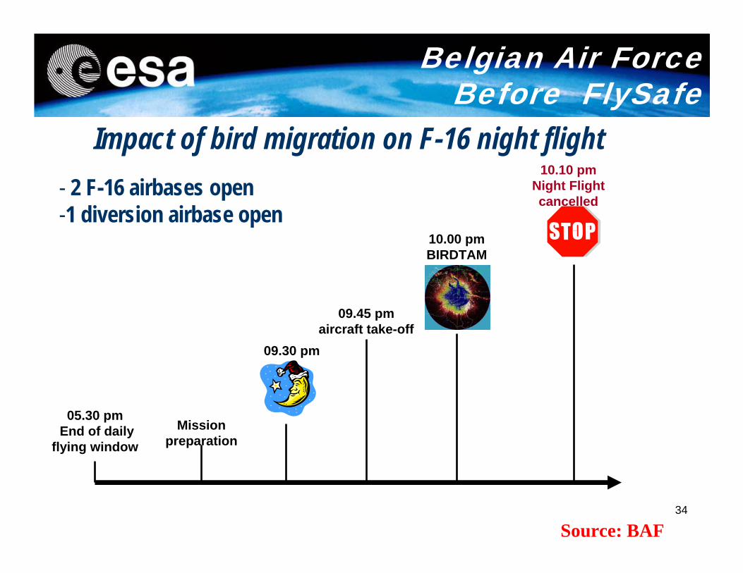
34
05.30 pmEnd of daily
flying window
09.45 pm aircraft take-off
Mission preparation
10.00 pm BIRDTAM
09.30 pm
10.10 pm Night Flight cancelled
- 2 F-16 airbases open-1 diversion airbase open
Belgian Air Force Before FlySafe
Impact of bird migration on F-16 night flight
Source: BAF
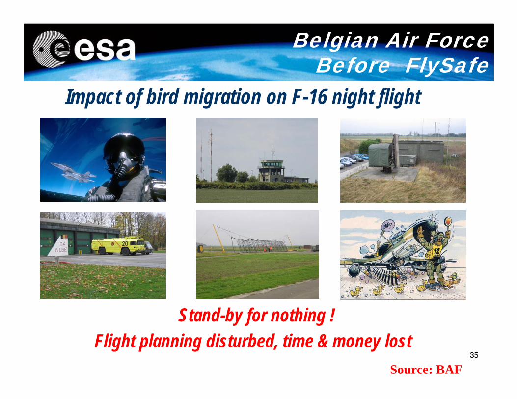
35
Stand-by for nothing !Flight planning disturbed, time & money lost
Belgian Air ForceBefore FlySafe
Impact of bird migration on F-16 night flight
Source: BAF
36
http://public.flysafe.sara.nl/bambas/
37
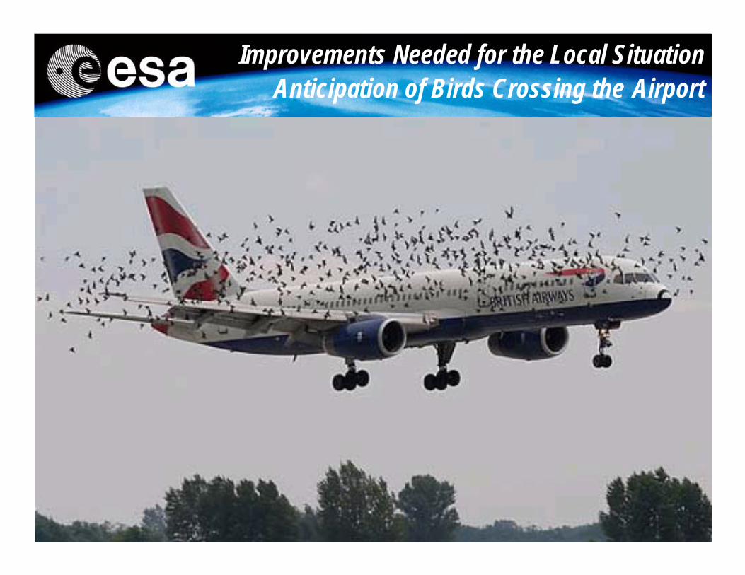
Improvements Needed for the Local Situation Anticipation of Birds Crossing the Airport
Improvements Needed for the Local Situation Anticipation of Birds Crossing the Airport
38
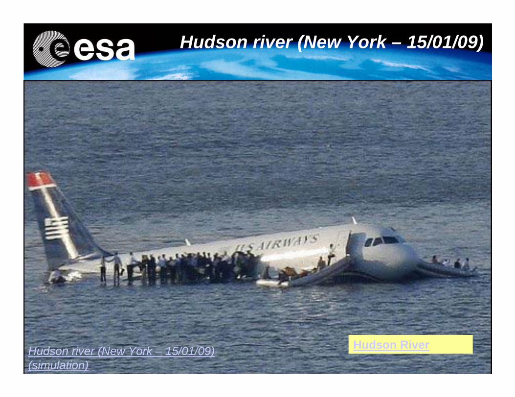
Hudson river (New York – 15/01/09)
Hudson river (New York – 15/01/09)(simulation)
Hudson River
39
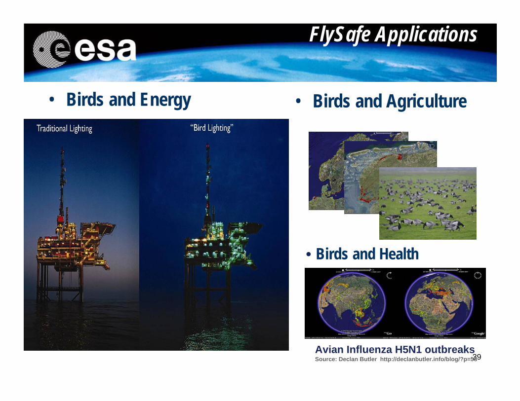
FlySafe Applications
• Birds and Energy • Birds and Agriculture
• Birds and Health
Avian Influenza H5N1 outbreaksSource: Declan Butler http://declanbutler.info/blog/?p=58
40
Application Driven Small Satellite MissionsEuropean AIS Mission
41
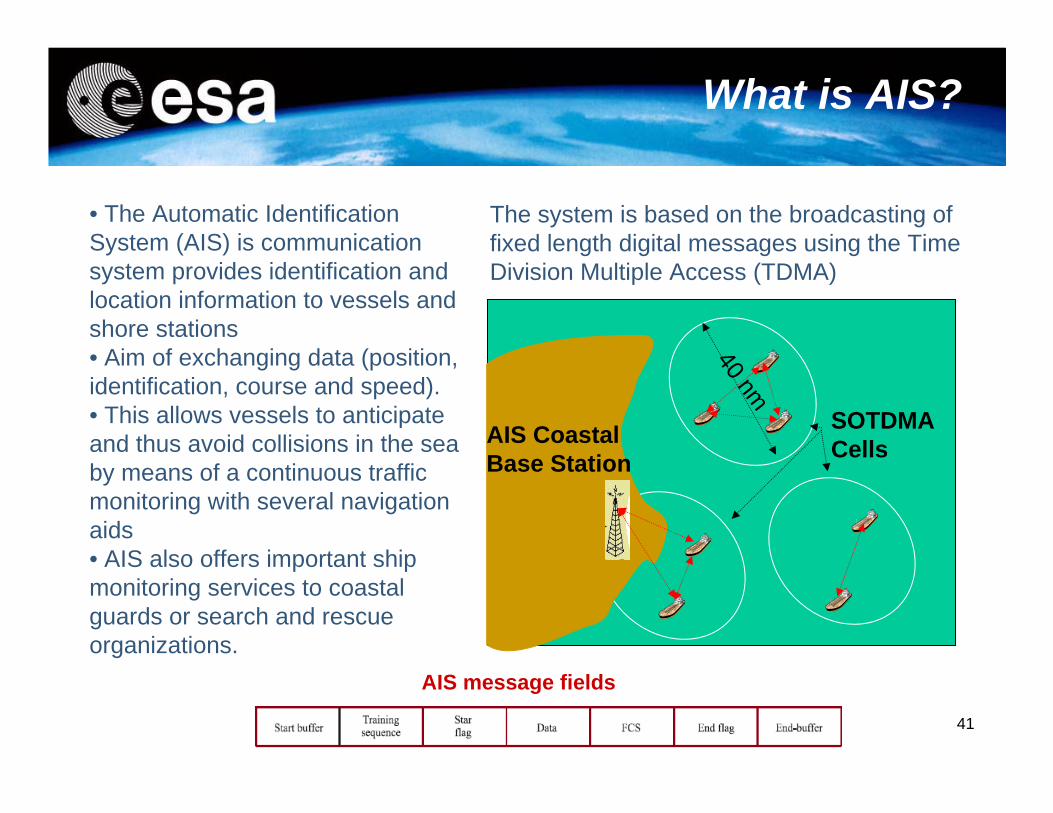
40 nm
AIS Coastal Base Station
SOTDMACells
What is AIS?
• The Automatic Identification System (AIS) is communication system provides identification and location information to vessels and shore stations • Aim of exchanging data (position, identification, course and speed). • This allows vessels to anticipate and thus avoid collisions in the sea by means of a continuous traffic monitoring with several navigation aids• AIS also offers important ship monitoring services to coastal guards or search and rescue organizations.
The system is based on the broadcasting of fixed length digital messages using the Time Division Multiple Access (TDMA)
AIS message fields
42
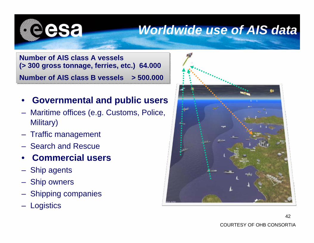
• Governmental and public users– Maritime offices (e.g. Customs, Police,
Military)– Traffic management– Search and Rescue• Commercial users– Ship agents– Ship owners– Shipping companies– Logistics
Worldwide use of AIS data
Number of AIS class A vessels(> 300 gross tonnage, ferries, etc.) 64.000Number of AIS class B vessels > 500.000
Number of AIS class A vessels(> 300 gross tonnage, ferries, etc.) 64.000Number of AIS class B vessels > 500.000
COURTESY OF OHB CONSORTIA
43
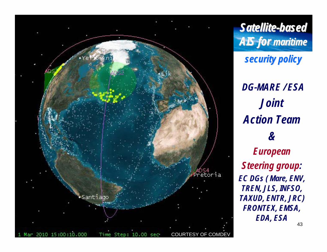
SatelliteSatellite--based based AIS for AIS for maritime maritime
security policysecurity policy
DG-MARE / ESAJoint
Action Team &
European Steering group:
EC DGs ( Mare, ENV, TREN, JLS, INFSO,
TAXUD, ENTR, JRC) FRONTEX, EMSA,
EDA, ESA
COURTESY OF COMDEV
44
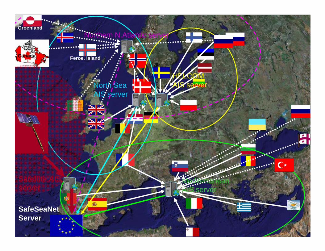
HELCOMAIS serverNorth Sea
AIS server
MediterraneanAIS server
SafeSeaNetServer
Northern N.Atlantic serverGroenland
Feroe. IslandCanada
Satellite AIS server
45COURTESY OF lUXSPACE
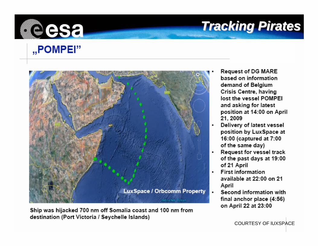
Tracking PiratesTracking Pirates
46
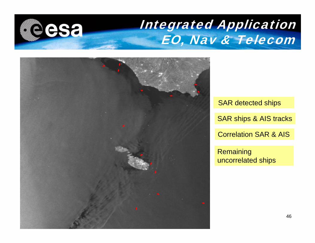
SAR detected ships
SAR ships & AIS tracks
Correlation SAR & AIS
Remaining uncorrelated ships
Integrated Application EO, Nav & Telecom
47
• The IAP initiative is an opportunity for ESA and Europe to demonstrate and promote the added-value of Space in support of Member States, European public policies and citizens in various new domains, beyond current individual space programmes.
• The IAP initiative is an opportunity for European & Canadian operators and Industry to exploit their expertise for the purpose of new initiatives and to identify new lines of business in various fields.
• The leveraging and systematic expansion of the EO, Navigation and Telecom domains through the IAP initiative is expected
Conclusions
48
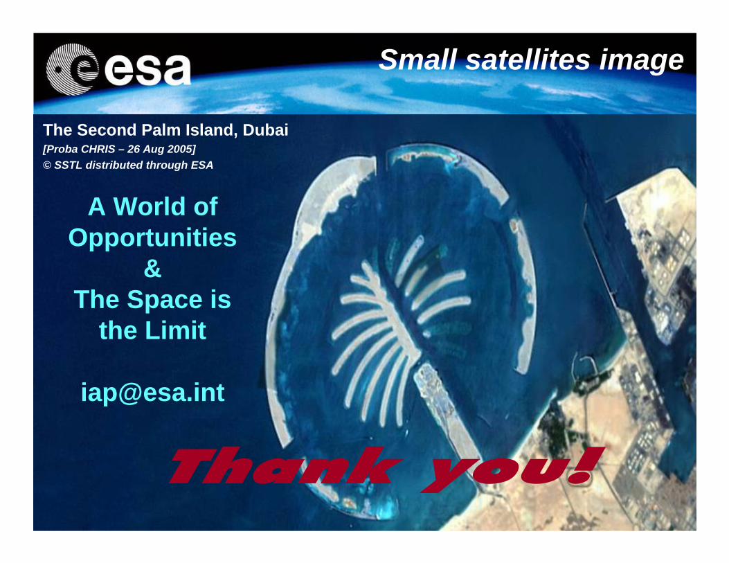
The Second Palm Island, Dubai[Proba CHRIS – 26 Aug 2005] © SSTL distributed through ESA
Small satellites image
A World of Opportunities
&The Space is
the Limit


![IAP antagonists sensitize murine osteosarcoma cells to ... · IAP activity within cells can be reduced by Smac/ Diablo, a natural IAP antagonist protein [14, 15]. A number of “IAP](https://img.pdfslide.us/doc/110x75/5c25d3f409d3f28d198c1460/iap-antagonists-sensitize-murine-osteosarcoma-cells-to-iap-activity-within.jpg)