Embed Size (px)
Citation preview
Rampion Offshore Wind Farm
ES Section 23 – Surface Water Hydrology
and Flood Risk - Appendix 23.2
RSK Environment Ltd Document 6.3.23ii
December 2012
APFP Regulation 5(2)(a)
Revision A
E.ON Climate & Renewables UK Rampion Offshore Wind Limited
NOVEMBER 2012
E.ON
Rampion Substation Flood Risk Assessment
41318 FRA R2 (3)
E.ON
Rampion Substation Flood Risk Assessment
41318- FRA R2 (3)
RSK GENERAL NOTES
Project No.: 41318- FRA R2 (3)
Title: Rampion Substation Flood Risk Assessment
Client: E.ON
Date: November 2012
Office: Helsby
Status: Final
Author C Whittingham Technical reviewer I Clark
Signature
Signature
Date: 27/11/12 Date: 27/11/12
Project manager K Barlow
Signature
Date: 27/11/12
RSK LDE (RSK) has prepared this report for the sole use of the client, showing reasonable skill and care, for the intended purposes as stated in the agreement under which this work was completed. The report may not be relied upon by any other party without the express agreement of the client and RSK. No other warranty, expressed or implied, is made as to the professional advice included in this report.
Where any data supplied by the client or from other sources have been used, it has been assumed that the information is correct. No responsibility can be accepted by RSK for inaccuracies in the data supplied by any other party. The conclusions and recommendations in this report are based on the assumption that all relevant information has been supplied by those bodies from whom it was requested.
No part of this report may be copied or duplicated without the express permission of RSK and the party for whom it was prepared.
Where field investigations have been carried out, these have been restricted to a level of detail required to achieve the stated objectives of the work.
This work has been undertaken in accordance with the quality management system of RSK LDE
E.ON i
Rampion Substation Flood Risk Assessment
41318- FRA R2 (3)
CONTENTS
1 INTRODUCTION ..............................................................................................................................2
2 CONTEXT AND SCOPE OF WORKS .............................................................................................3
3 SITE DESCRIPTION ........................................................................................................................4
3.1 Site Location.............................................................................................................................4
3.2 Study Area Hydrology ..............................................................................................................4
4 DEVELOPMENT PROPOSALS.......................................................................................................5
5 SOURCE OF FLOOD RISK .............................................................................................................6
5.1 Environment Agency Flood Zone .............................................................................................6
5.2 Flooding from Rivers (Fluvial Flood Risk) ................................................................................6
5.3 Flooding from the Sea (Tidal Flood Risk).................................................................................6
5.4 Flooding from the Land (Overland Pluvial Flood Risk).............................................................7
5.5 Flooding from Groundwater......................................................................................................7
5.6 Flooding from Sewers ..............................................................................................................7
5.7 Flooding From Reservoirs, Canals and Other Artificial Structures ..........................................8
5.8 Historic Flooding.......................................................................................................................8
6 SURFACE WATER DRAINAGE......................................................................................................9
6.1 Scope 9
6.2 Existing Site Run-off .................................................................................................................9
6.3 Impact of Proposed Development ..........................................................................................10
6.4 Climate Change......................................................................................................................10
6.5 Ditch Diversion .......................................................................................................................10
7 PLANNING CONTEXT...................................................................................................................12
7.1 Application of Planning Policy ................................................................................................12
7.2 Land Use Vulnerability ...........................................................................................................12
7.3 Sequential and Exception Tests.............................................................................................12
8 MITIGATION MEASURES AND RECOMMENDATIONS .............................................................14
9 CONCLUSIONS AND RECOMMENDATIONS .............................................................................15
10 REFERENCES ...............................................................................................................................16
FIGURES
Figure 1 Site Location Plan
Figure 2 Environment Agency Flood Zone Mapping
APPENDICES
Appendix A Service Constraints
Appendix B SFRA Groundwater Flood Risk Mapping
Appendix C Historic Flood Mapping
Appendix D Microdrainage Calculation Sheet
E.ON 2
Rampion Substation Flood Risk Assessment
41318- FRA R2 (3)
1 INTRODUCTION
RSK LDE Limited has been commissioned by E.ON to undertake a Flood Risk Assessment
(FRA) and review the constraints on a proposed substation site located adjacent to an existing
National Grid Substation near Bolney. This report assesses the flood risk associated with the
development of the proposed onshore substation and is included as an addendum to the
hydrology chapter of the Environmental Statement.
The publication of the National Planning Policy Framework (NPPF, Ref.1) has revoked PPS 25
(Ref. 2) amongst others on 27th April 2012. The Technical Guidance to the National Planning
Policy Framework (April 2012) (Ref. 3) includes flood risk guidance and retains key elements of
PPS 25 (Ref. 3) including the Sequential and Exception Tests, climate change allowances and
development classifications. The information contained in this new technical guidance along with
the NPPF when combined with guidance contained in the Communities and Local Government
“Planning Policy Statement 25: Development and Flood Risk Practice Guide”, Dec 2009 (Ref. 4)
and the British Standard BS 8533-2011 "Assessing and managing flood risk in development
Code of practice" (Ref. 5) will form the basis of any on-going RSK flood risk documentation. This FRA was prepared based on PPS25 and the accompanying guidance documentation as well
as the BS. As a result, the publication of the NPPF containing much of the main criteria for
assessing flood risk will not alter the conclusions or recommendations of this report.
The Environment Agency have confirmed the extent of the Flood Zones adjacent to the site, this
confirms that the latest flood map shows that the site is located wholly within Flood Zone 1.
The comments given in this report and the opinions expressed are subject to RSK Group Service
Constraints provided in Appendix A.
E.ON 3
Rampion Substation Flood Risk Assessment
41318- FRA R2 (3)
2 CONTEXT AND SCOPE OF WORKS
A key element of project development is to prepare a Flood Risk Assessment to establish the risk
associated with the proposed development and to propose suitable mitigation, if required to
reduce the risk to a more acceptable level.
Although officially revoked and replaced by the NPPF (Ref. 1) the scope of work relating to a
flood risk assessment is based on the guidance provided in PPS 25 (Ref. 2) and the
accompanying guidance published by the Communities and Local Government Office (Ref. 4)
and comprise of the following elements:
• To obtain information on the hydrology and hydrological regime in and around the site.
• To obtain the views of the Environment Agency including scope, location and impacts.
• To determine the extent of new flooding provision and the influence on the site.
• To review site surface water drainage based on the proposed layout. To determine the
extent of infrastructure required.
• To review architect plans and planning information and other studies to determine the
existing site conditions.
• To assess the impact on the site from global warming effects and anticipated increases in
rainfall over a 100 year period for residential use or 60 years for commercial uses.
• Preparation of a report including calculations and summaries of the source information
and elements reviewed.
E.ON 4
Rampion Substation Flood Risk Assessment
41318- FRA R2 (3)
3 SITE DESCRIPTION
3.1 Site Location
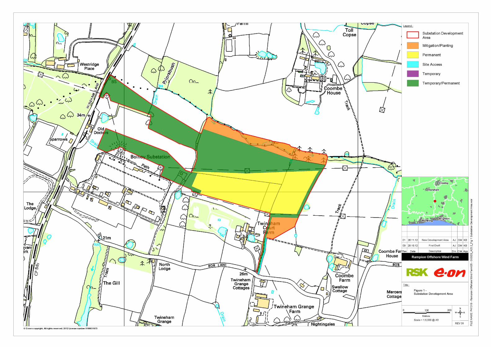
The preferred location for the substation site is located to the north east of the of the existing
Bolney substation located at NGR: TQ 24422 20992, see Figure 1. The site can be divided into
two land areas; the total red line boundary which includes the areas set aside for construction,
this area will be considered to be a temporary construction area, and the second is the
permanent land taker area which will consist of the more permanent infrastructure of the
substation itself. This report will concentrate on the permanent land take area as the temporary
site area will be restored with no permanent features on the site.
The total site is bounded by:
• North –bounded by open agricultural land and woodland. A small watercourse
flows in a easterly direction along the northern boundary.
• East – Directly bounded open agricultural land, the existing overhead connection
to Bolney substation is located to the east of the site
• South – Directly bounded by open agricultural land (Twinham Court Farm) and
the existing Bolney substation to the south west
• West – Directly bounded by the existing Bolney Substation site and open fields.
The calculations in this report are based on a maximum permanent land take area of 7.15 Ha.
Located adjacent to the site are three existing overhead line circuits; these consist of a
distribution Network Operator (DNO) 11kV overhead line running north to south through the
middle of the site for supplying nearby farms and local residents. To the south of the site is a
DNO 132kV overhead line running west to east which is connected into Bolney 132kV Substation
by a cable circuit with 2 off 132kV towers sited within the site. To the north is a 400kV overhead
line double circuit and single tower connected into Bolney 400kV Substation running west to east.
An underground cable circuit has recently been installed through this land to the east of the
National Grid compound and the west of the 132kV terminal tower located in the west of the site.
3.2 Study Area Hydrology
The area surrounding the proposed substation site contains a number of surface water features
including approximately 23 surface water lagoons, possibly associated with water retention for
irrigation purposes. A small drainage ditch is located running parallel to an existing north south
hedge line.
E.ON 5
Rampion Substation Flood Risk Assessment
41318- FRA R2 (3)
4 DEVELOPMENT PROPOSALS
The onshore substation is a key component of the project and will be required to convert
electricity generated at the wind farm to a higher voltage suitable for onward transmission by
National Grid’s electricity transmission system.
The substation will consist of four Super Grid Transformer (SGT) bays, with each bay having a
minimum capacity of 180 MVA. The transformers will step up the voltage of the offshore wind
farm transmission system (which may be 132kV, 150kV or 220kV) up to the National Grid
transmission voltage of 400kV for connection into Bolney substation. The substation will be
directly connected to the National Grid (NGET) 400 kV substation via Gas Insulated Busbar
(GIB).
E.ON 6
Rampion Substation Flood Risk Assessment
41318- FRA R2 (3)
5 SOURCE OF FLOOD RISK
In accordance with NPPF (Ref. 1) and advice from the Environment Agency, a prediction of the
flood sources and levels is required along with the effects of climate change from the present for
the design life of the development (in this case assumed to be 100 years). To consider these
effects of climate change, NPPF Technical Guidance Table 5 recommends consideration of a
30% increase in rainfall intensity and 20% increase in peak river flows over this timeframe.
The flood risk elements that need to be considered for any site are defined in BS 8533 as the
“Forms of Flooding” and are listed as:
• Flooding from Rivers (fluvial flood risk)
• Flooding from the Sea (tidal flood risk)
• Flooding from the Land
• Flooding from Groundwater
• Flooding from Sewers (sewer and drain exceedance, pumping station failure etc)
• Flooding from Reservoirs, Canals and other Artificial Structures
The following section reviews each of these in respect of the subject site.
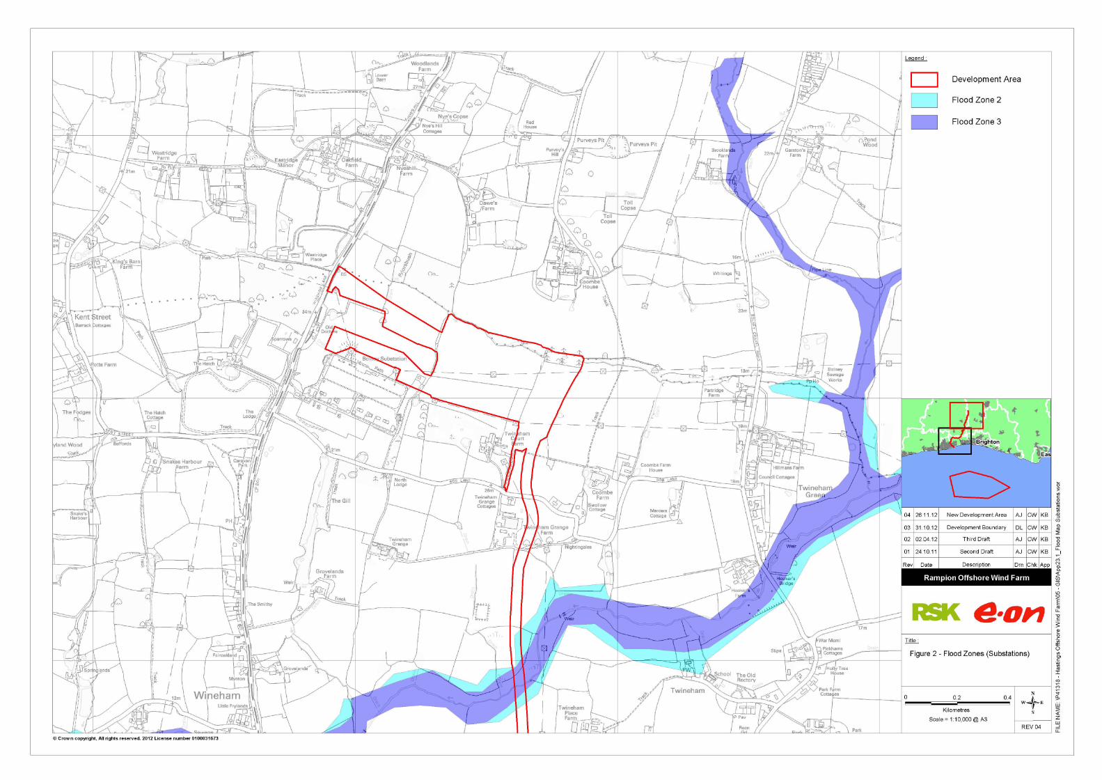
5.1 Environment Agency Flood Zone
The Environment Agency (Environment Agency) has produced Flood Zone maps for much of
England and Wales. The current displayed map is reproduced as Figure 2. The latest Flood
Zone map shows the flood risk to the site from fluvial and tidal sources is low.
5.2 Flooding from Rivers (Fluvial Flood Risk)
As can be seen from the Environment Agency Flood Zone map, the site is located wholly within
Flood Zone 1.
The minor watercourses located to the north of the proposed development site is not shown on
the Environment Agency Flood Zone mapping, however flood risk from this source is considered
low and does not pose a flood risk to the site.
5.3 Flooding from the Sea (Tidal Flood Risk)
On the coast storm surges and high tides can threaten low lying coastal areas, and can be
sometimes large and rapid enough to overtop defence works, causing significantly more damage
than river flooding.
Tidal flood risk is not an issue due to the location inland.

E.ON 7
Rampion Substation Flood Risk Assessment
41318- FRA R2 (3)
5.4 Flooding from the Land (Overland Pluvial Flood Risk)
If intense rain is unable to soak into the ground or be carried through manmade drainage
systems, for a variety of reasons, it can run off over the surface causing localised floods before
reaching a river or other watercourse.
Generally, where there is impermeable surfacing or where the ground infiltration capacity is
exceeded, surface water runoff will occur. Excess surface water flows from the site are believed
to drain naturally to the local water features, either by overland flow or through infiltration.
There is no evidence, that pluvial or overland flooding will affect the site. Flooding from this
source is considered low and will be considered within the layout of the site, ensuring the
development is not at increased risk and overland flow routes will be created within the design of
the site to ensure properties are not at risk of flooding from this source.
Excess surface water flows from the site are believed to drain naturally to the local water
features, either by overland flow or through infiltration. Flooding from this source is considered
low and will be considered within the layout of the site, ensuring the development is not at
increased risk.
Flooding of the site from this source is considered low.
5.5 Flooding from Groundwater
Groundwater flooding is caused by the natural emergence at the ground surface, of water
originating from underlying permeable sediments or rocks (aquifers). The groundwater may
emerge as one or more point discharges (springs) or as diffuse discharge/seepage over an
extended area. Groundwater flooding tends to be more persistent than other sources of flooding,
typically lasting for weeks or months rather than for hours or days.
Groundwater flooding does not generally pose a significant risk to life due to the slow rate at
which the water level rises; however, it can cause significant damage to property, especially in
urban areas. The soils around the substation site are generally impermeable and therefore
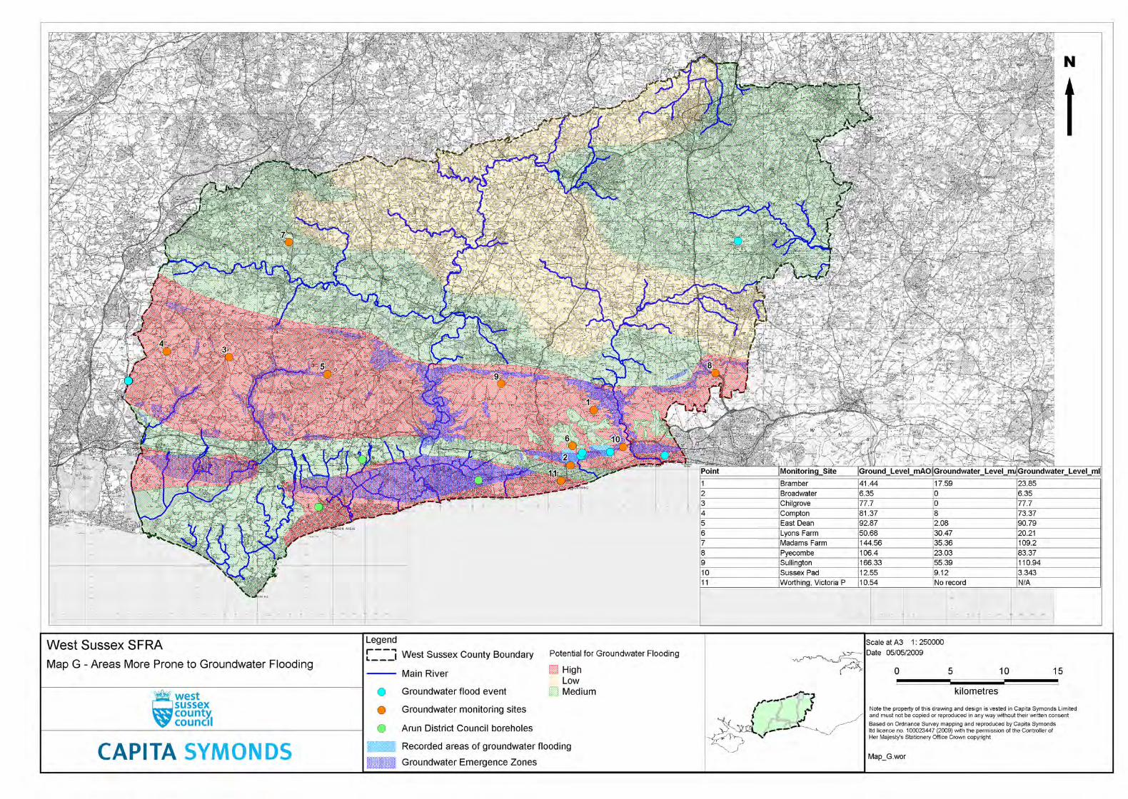
largely unresponsive to groundwater levels due to low infiltration, a copy of the SFRA
Groundwater flood risk map is included as Appendix B.
Due to the type of development proposed, it is not thought that groundwater flooding will impact on the operations on the site.
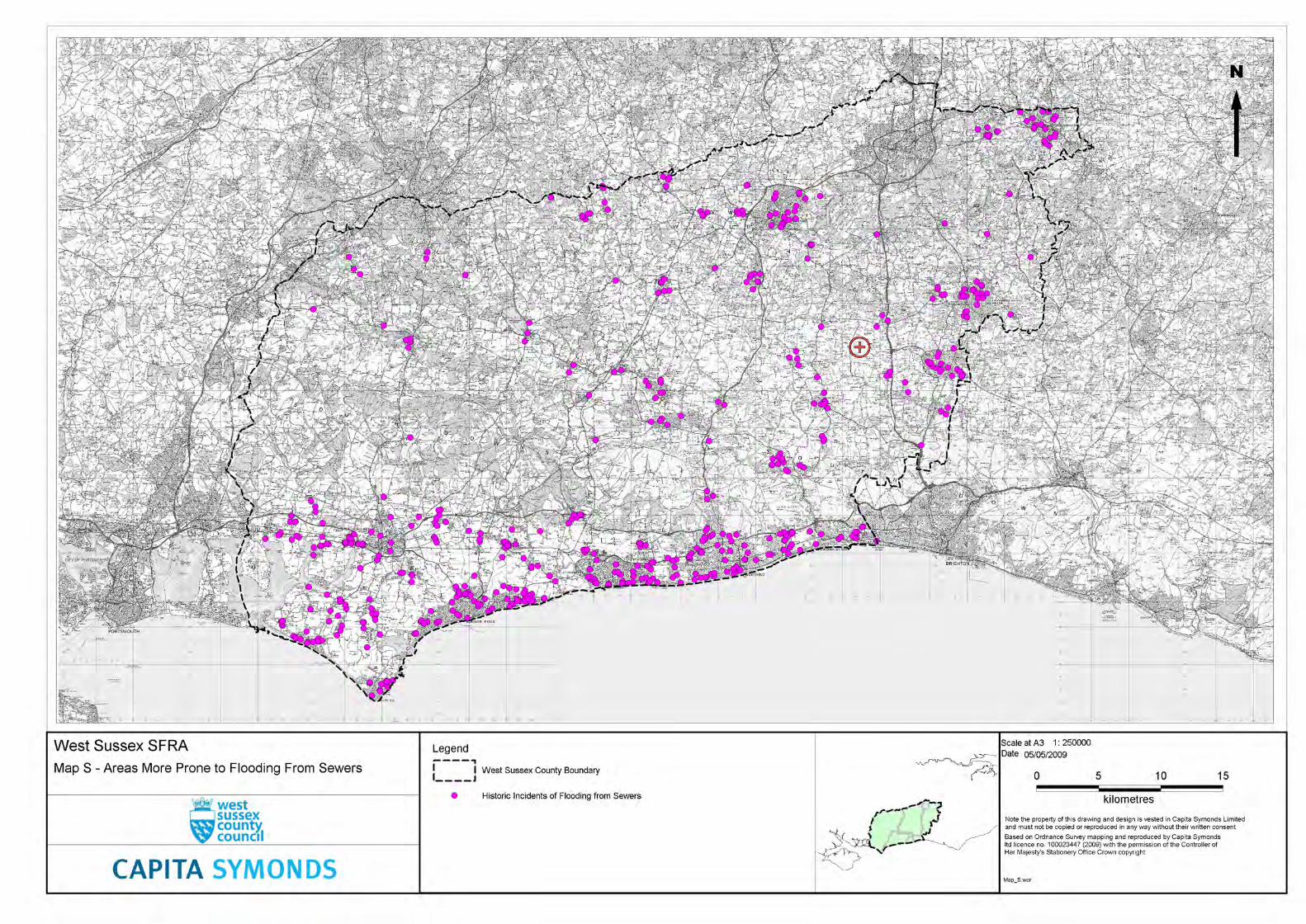
5.6 Flooding from Sewers
Most adopted surface water drainage networks are designed to the criteria set out in Sewers for
Adoption (Ref. 4). One of the design parameters is that sewer systems be designed such that no
flooding of any part of the site occurs in a 1 in 30 year rainfall event. By definition a 1 in 100 year
event would exceed the capacity of the surrounding sewer network as well as any proposed
drainage.
When exceeded, the surcharged pipework will lead to flooding from backed up manholes and
gully connections. This will lead to immediate flooding within highways surrounding the site.
The site does not benefit from a formal sewerage system, therefore flood risk from this source is
low.
E.ON 8
Rampion Substation Flood Risk Assessment
41318- FRA R2 (3)
5.7 Flooding From Reservoirs, Canals and Other Artificial
Structures
A number of small ponded areas have been identified from the OS mapping, following a walk
over of the surrounding area it has been confirmed that all these waterbodies are retained below
the surrounding ground levels and are not retained by embankment. Therefore flooding from
these waterbodies is considered to be low.
There are no other potential sources of flood risk known to the site.
5.8 Historic Flooding
There have been no recorded incidence of flooding in close proximity to the proposed substation
site, Appendix C.
E.ON 9
Rampion Substation Flood Risk Assessment
41318- FRA R2 (3)
6 SURFACE WATER DRAINAGE
6.1 Scope
An outline drainage strategy has been carried out to identify the options for the design of the
surface water drainage system and how it will affect the site layout using the following data:
• estimate the discharge rate for the site. Greenfield discharge rates should be sought
on greenfield sites, and also on brownfield sites (where possible)
• estimate the volume of 1 in 100 year attenuation to be provided
• take into account NPPF’s climate change requirements.
PPS25 states that SuDS should be considered wherever practical. In addition, Building
Regulations Part H requires that the first choice of surface water disposal should be to discharge
to an adequate soakaway or infiltration system, where practicable. If this is not reasonably
practicable then discharge should be to a watercourse, the least favourable option being to a
local sewer. Infiltration techniques should therefore be applied wherever they are appropriate.
The proposed development site currently comprises of open grassland. The site will be
developed to include a substation and will incorporate a substantial area of hardstanding.
Without the inclusion of appropriate mitigation measures the proposed development could,
therefore, increase surface water runoff rates and volumes from the site as a consequence of
increasing the area of built infrastructure and hard landscaping. It is intended that the proposed
development will attenuate surface water run-off rates and volumes from hardstanding and
impermeable roof areas by incorporating SuDs into the design when the scheme progresses to a
more detailed design stage.
6.2 Existing Site Run-off
The site does not benefit from a formal drainage system; it is proposed to design a surface water
system to ensure that discharge from the post development site does not exceed that of the pre-
development situation, whilst managing any potential exceedance of the drainage network. In
addition, PPS 25 (paragraph 5) makes it clear that off-site impacts should not increase flood risk
elsewhere. The Practice Guide (Ref. 5) States:
For the range of annual flow rate probabilities up to and including the one per cent
annual exceedance probability (1 in 100 years) event, including an appropriate
allowance for climate change, the developed rate of run-off into a watercourse, or
other receiving water body, should be no greater than the existing rate of run-off for
the same event. Run-off from previously developed sites should be compared with
existing rates, not greenfield rates for the site before it was developed. Developers
are, however, strongly encouraged to reduce run-off rates from previously developed
sites as much as is reasonably practicable. Volumes of run-off should also be
reduced wherever possible using infiltration and attenuation techniques. Interim
guidance on calculation of site run-off rates can be found at
http://www.ciria.org/suds/pdf/preliminary_rainfall_runoff_mgt_for_development.pdf
E.ON 10
Rampion Substation Flood Risk Assessment
41318- FRA R2 (3)
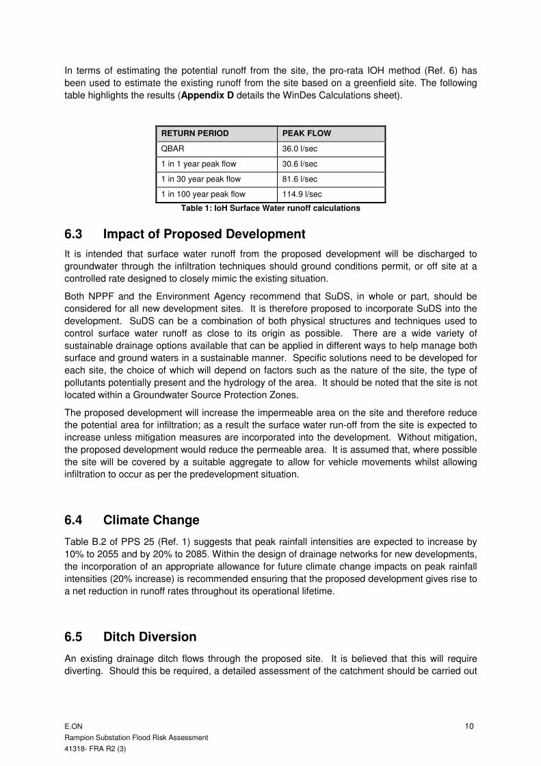
In terms of estimating the potential runoff from the site, the pro-rata IOH method (Ref. 6) has
been used to estimate the existing runoff from the site based on a greenfield site. The following
table highlights the results (Appendix D details the WinDes Calculations sheet).
RETURN PERIOD PEAK FLOW
QBAR 36.0 l/sec
1 in 1 year peak flow 30.6 l/sec
1 in 30 year peak flow 81.6 l/sec
1 in 100 year peak flow 114.9 l/sec
Table 1: IoH Surface Water runoff calculations
6.3 Impact of Proposed Development
It is intended that surface water runoff from the proposed development will be discharged to
groundwater through the infiltration techniques should ground conditions permit, or off site at a
controlled rate designed to closely mimic the existing situation.
Both NPPF and the Environment Agency recommend that SuDS, in whole or part, should be
considered for all new development sites. It is therefore proposed to incorporate SuDS into the
development. SuDS can be a combination of both physical structures and techniques used to
control surface water runoff as close to its origin as possible. There are a wide variety of
sustainable drainage options available that can be applied in different ways to help manage both
surface and ground waters in a sustainable manner. Specific solutions need to be developed for
each site, the choice of which will depend on factors such as the nature of the site, the type of
pollutants potentially present and the hydrology of the area. It should be noted that the site is not
located within a Groundwater Source Protection Zones.
The proposed development will increase the impermeable area on the site and therefore reduce
the potential area for infiltration; as a result the surface water run-off from the site is expected to
increase unless mitigation measures are incorporated into the development. Without mitigation,
the proposed development would reduce the permeable area. It is assumed that, where possible
the site will be covered by a suitable aggregate to allow for vehicle movements whilst allowing
infiltration to occur as per the predevelopment situation.
6.4 Climate Change
Table B.2 of PPS 25 (Ref. 1) suggests that peak rainfall intensities are expected to increase by
10% to 2055 and by 20% to 2085. Within the design of drainage networks for new developments,
the incorporation of an appropriate allowance for future climate change impacts on peak rainfall
intensities (20% increase) is recommended ensuring that the proposed development gives rise to
a net reduction in runoff rates throughout its operational lifetime.
6.5 Ditch Diversion
An existing drainage ditch flows through the proposed site. It is believed that this will require
diverting. Should this be required, a detailed assessment of the catchment should be carried out

E.ON 11
Rampion Substation Flood Risk Assessment
41318- FRA R2 (3)
and any works should ensure that the new diverted ditch can convey the flows without any
additional flood risk.

E.ON 12
Rampion Substation Flood Risk Assessment
41318- FRA R2 (3)
7 PLANNING CONTEXT
7.1 Application of Planning Policy
NPPF includes (Section 10) measures specifically dealing with development planning
and flood risk using a sequential characterisation of risk based on planning zones and
the Environment Agency Flood Map. The main study requirement is to identify the flood
zones and vulnerability classification relevant to the proposed development, based on
an assessment of current and future conditions.
Within NPPF Technical Guidance on flood risk each flood zone has a list of appropriate
land uses dependent on vulnerability to flooding.
7.2 Land Use Vulnerability
From the NPPF Technical Guidance, a “less vulnerable” land use could be appropriate
to Flood Zone 3a (High Probability of flooding at higher than 1 in 100 annual probability)
with the “more vulnerable” use only permitted if the exception test is passed. For a
“more vulnerable” class, development on this site could be appropriate within Flood
Zone 2 (Medium Probability of flooding at less than 1 in 100 but higher than 1 in 1,000
annual probability).
In applying the sequential test, reference is made to the following table (reproduced from
Table 3 contained within NPPF);
Table 7.1 Flood Risk Vulnerability and Flood Zone ‘Compatibility’
Flood Risk Vulnerability Classification
Essential
Infrastructure
Water
Compatible
Highly
Vulnerable
More
Vulnerable
Less
Vulnerable
Zone 1 Appropriate Appropriate Appropriate Appropriate Appropriate
Zone 2 Appropriate Appropriate Exception
Test Required
Appropriate Appropriate
Zone 3a Exception Test
Required Appropriate
Should not be permitted
Exception Test
Required Appropriate
Flood Zone
Zone 3b functional floodplain
Exception Test Required
Appropriate Should not be
permitted
Should not be
permitted
Should not be permitted
7.3 Sequential and Exception Tests
The Sequential Test is required to assess flood risk and NPPF Technical Guidance recommends
that the test be applied at all stages of the planning process to direct new development to areas
with the lowest probability of flooding (Flood Zone 1).
According to NPPF, if there is no reasonably available site in Flood Zone 1, the flood vulnerability
of the proposed development (see NPPF Technical Guidance Table 2) can be taken into account
E.ON 13
Rampion Substation Flood Risk Assessment
41318- FRA R2 (3)
in locating development in Flood Zone 2 and then Flood Zone 3. Within each Flood Zone new
development should be directed to sites at the lowest probability of flooding from all sources.
The site can be classified as greenfield and used as agricultural land, the proposed development
of a substation will change its planning designation to wholly essential infrastructure. From
NPPF, an “essential infrastructure” land use is appropriate within Flood Zone 1. As discussed
above all development on this site is to be located within Flood Zone 1, therefore development
will be possible. The Sequential and Exception Tests are not essential for this development.
E.ON 14
Rampion Substation Flood Risk Assessment
41318- FRA R2 (3)
8 MITIGATION MEASURES AND RECOMMENDATIONS
The site is not a direct risk of tidal or fluvial flooding and hence the mitigation measures relate to
the provision of drainage controls as described in this report.
With the exception of access roads and roofed areas the majority of the site will be covered by a
suitable aggregate to allow for vehicle movements whilst allowing infiltration to occur as per the
predevelopment situation, thus limiting the impact of the development on the existing surface
water regime in the area.
Unless otherwise agreed in writing there is no intention to abstract water from watercourses or
waterbodies adjacent to the site. All existing ditches and field drains in close proximity to the
operational site will be maintained and kept free from potential obstruction. An existing drainage
ditch flows through the proposed site. It is believed that this will require diverting to allow
development to occur. Should this be required, a detailed assessment of the catchment should
be carried out and any works should ensure that the new diverted ditch can convey the flows
without any additional flood risk.
E.ON 15
Rampion Substation Flood Risk Assessment
41318- FRA R2 (3)
9 CONCLUSIONS AND RECOMMENDATIONS
This flood risk assessment for the proposed substation site, located adjacent to the existing
Bolney Substation site has been carried out to ascertain the level of flood risk associated with the
development. This report confirms that the proposed development meets the requirements of the
NPPF in relation to flood risk to the site and posed by the site following development.
The proposed site lie is within Flood Zone 1 according to the latest Environment Agency Flood
Zone map. This FRA has carried out investigations into other potential sources of flood risk and
concludes that the risk to the site remains low.
The surface water drainage scheme for the site should be designed to meet the requirements of
the NPPF by limiting the post development off site run-off to the equivalent predevelopment rate
for the site whilst providing sufficient on site attenuation for rainfall events up to the 1 in 100-year
rainfall event, including a suitable allowance for climate change over the lifetime of the
development.
E.ON 16
Rampion Substation Flood Risk Assessment
41318- FRA R2 (3)
10 REFERENCES
1. Communities and Local Government “National Planning Policy Framework” NPPF,
Mar 2012.
2. Communities and Local Government “Planning Policy Statement – Development
and Flood Risk” PPS 25, Mar 2010.
3. Communities and Local Government “Technical Guidance to the National Planning
Policy Framework”, Mar 2012.
4. DEFRA “Interim Code of Practice for Sustainable Drainage Systems” National
SUDS Working Group, July 2004.
5. BS 8533-2011 Assessing and managing flood risk in development Code of practice,
Nov 2011.
6. Institute of Hydrology (IoH) “Flood Estimation for small catchments” Report 124,
1994

Report No. 41358-FRA R2(3)
FIGURES

Report No. 41358-FRA R2(3)
APPENDIX A
Service Constraints
Report No. 41358-FRA R2(3)
RSK GROUP
SERVICE CONSTRAINTS
1. This report and the Drainage design carried out in connection with the report (together the "Services") were compiled and carried out by RSK LDE Ltd (RSK) for E.On. (the "client") in accordance with the terms of a contract between RSK and the "client" . The Services were performed by RSK with the skill and care ordinarily exercised by a reasonable Civil Engineer at the time the Services were performed. Further, and in particular, the Services were performed by RSK taking into account the limits of the scope of works required by the client, the time scale involved and the resources, including financial and manpower resources, agreed between RSK and the client.
2. Other than that expressly contained in paragraph 1 above, RSK provides no other representation or warranty whether express or implied, in relation to the Services.
3. Unless otherwise agreed the Services were performed by RSK exclusively for the purposes of the client. RSK is not aware of any interest of or reliance by any party other than the client in or on the Services. Unless expressly provided in writing, RSK does not authorise, consent or condone any party other than the client relying upon the Services. Should this report or any part of this report, or otherwise details of the Services or any part of the Services be made known to any such party, and such party relies thereon that party does so wholly at its own and sole risk and RSK disclaims any liability to such parties. Any such party would be well advised to seek independent advice from a competent environmental consultant and/or lawyer.
4. It is RSK’s understanding that this report is to be used for the purpose described in the introduction to the report. That purpose was a significant factor in determining the scope and level of the Services. Should the purpose for which the report is used, or the proposed use of the site change, this report may no longer be valid and any further use of or reliance upon the report in those circumstances by the client without RSK's review and advice shall be at the client's sole and own risk. Should RSK be requested to review the report after the date hereof, RSK shall be entitled to additional payment at the then existing rates or such other terms as agreed between RSK and the client.
5. The passage of time may result in changes in site conditions, regulatory or other legal provisions, technology or economic conditions which could render the report inaccurate or unreliable. The information and conclusions contained in this report should not be relied upon in the future without the written advice of RSK. In the absence of such written advice of RSK, reliance on the report in the future shall be at the client's own and sole risk. Should RSK be requested to review the report in the future, RSK shall be entitled to additional payment at the then existing rate or such other terms as may be agreed between RSK and the client.
6. The observations and conclusions described in this report are based solely upon the Services, which were provided pursuant to the agreement between the client and RSK. RSK has not performed any observations, investigations, studies or testing not specifically set out or required by the contract between the client and RSK. RSK is not liable for the existence of any condition, the discovery of which would require performance of services not otherwise contained in the Services. For the avoidance of doubt, unless otherwise expressly referred to in the introduction to this report, RSK did not seek to evaluate the presence on or off the site of asbestos, electromagnetic fields, lead paint, heavy metals, radon gas or other radioactive or hazardous materials.
7. The Services are based upon RSK's observations of existing physical conditions at the Site gained from a walk-over survey of the site together with RSK's interpretation of information including documentation, obtained from third parties and from the client on the history and usage of the site. The Services are also based on information and/or analysis provided by independent testing and information services or laboratories upon which RSK was reasonably entitled to rely. The Services clearly are limited by the accuracy of the information, including documentation, reviewed by RSK and the observations possible at the time of the walk-over survey. Further RSK was not authorised and did not attempt to independently verify the accuracy or completeness of information, documentation or materials received from the client or third parties, including laboratories and information services, during the performance of the Services. RSK is not liable for any inaccurate information or conclusions, the discovery of which inaccuracies required the doing of any act including the gathering of any information which was not reasonably available to RSK and including the doing of any independent investigation of the information provided to RSK save as otherwise provided in the terms of the contract between the client and RSK.
8. The phase II or intrusive environmental site investigation aspects of the Services is a limited sampling of the site at pre-determined borehole and soil vapour locations based on the operational configuration of the site. The conclusions given in this report are based on information gathered at the specific test locations and can only be extrapolated to an undefined limited area around those locations. The extent of the limited area depends on the soil and groundwater conditions, together with the position of any current structures and underground facilities and natural and other activities on site. In addition chemical analysis was carried out for a limited number of parameters [as stipulated in the contract between the client and RSK] [based on an understanding of the available operational and historical information,] and it should not be inferred that other chemical species are not present.
9. Any site drawing(s) provided in this report is (are) not meant to be an accurate base plan, but is (are) used to present the general relative locations of features on, and surrounding, the site.
Report No. 41358-FRA R2(3)
APPENDIX B
SFRA Groundwater Flood Risk Mapping

Report No. 41358-FRA R2(3)
APPENDIX C
Historic Flood Mapping

Report No. 41358-FRA R2(3)
APPENDIX D
MicroDrainage Calculation Sheets

ICP SUDS Mean Annual Flood
Input
Return Period (years) 100 Soil 0.450
Area (ha) 7.010 Urban 0.000
SAAR (mm) 800 Region Number Region 7
Results l/s
QBAR Rural 36.0
QBAR Urban 36.0
Q100 years 114.9
Q1 year 30.6
Q30 years 81.6
Q100 years 114.9
RSK LDE Ltd
18 Frogmore Road
Hemel Hempstead
Herts, HP3 9RT
Date Nov 2012
File
Elstree Computing Ltd
Rampion
Substation
Greenfield RO
Designed By CW
Checked By
Source Control W.12.5
Page 1
©1982-2010 Micro Drainage Ltd