Embed Size (px)
Citation preview
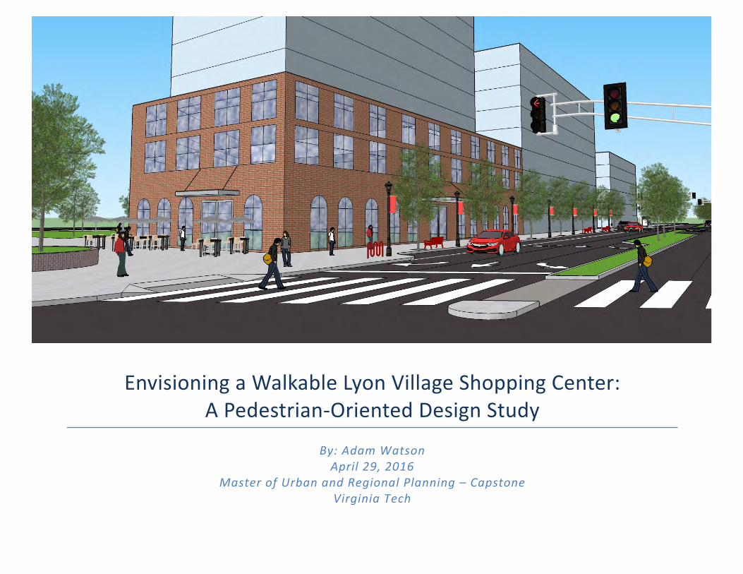
EnvisioningaWalkableLyonVillageShoppingCenter:APedestrian-OrientedDesignStudy
By:AdamWatsonApril29,2016
MasterofUrbanandRegionalPlanning–CapstoneVirginiaTech
2
TableofContentsExecutiveSummary............................................................................................................................................................4ProblemStatementandContext.....................................................................................................................................6LeeHighwayandLyonVillageShoppingCenterHistory.........................................................................................................................................7LeeHighwayVisioning.........................................................................................................................................................................................................9ProblemStatementandResearchObjective.............................................................................................................................................................10StudyArea.............................................................................................................................................................................................................................11SignificanceandBenefitsofaWalkableLyonVillageShoppingCenter..........................................................................................................12
ExistingPlans......................................................................................................................................................................13ArlingtonCountyPlans,Policies,andZoning...........................................................................................................................................................14GeneralLandUsePlan...............................................................................................................................................................................................................................14Zoning...............................................................................................................................................................................................................................................................15HistoricPreservation.................................................................................................................................................................................................................................16MasterTransportationPlan(MTP):GoalsandPoliciesSummary(GPS)............................................................................................................................17MasterTransportationPlan(MTP):StreetsElement..................................................................................................................................................................18MasterTransportationPlan(MTP):PedestrianElement..........................................................................................................................................................20MasterTransportationPlan(MTP):ParkingandCurbSpaceManagement(PCSM),andBicycleElements.......................................................21
CommunityInvolvement&Visioning.........................................................................................................................22Introduction.........................................................................................................................................................................................................................23LeeHighwayVisioning:CommunityInput.................................................................................................................................................................24Corridor-wideInput...................................................................................................................................................................................................................................25StudyArea-specificInput.........................................................................................................................................................................................................................27
InterviewwithBMCPropertyGroup...........................................................................................................................................................................29
BestPracticesinPedestrian-OrientedDesign:LiteratureReview...................................................................30Introduction.........................................................................................................................................................................................................................31DesigningWalkableUrbanThoroughfares:AContextSensitiveApproach(ITE/CNU).................................................................................32MultimodalSystemDesignGuidelines(DRPT)..........................................................................................................................................................34UrbanStreetDesignGuide(NACTO).............................................................................................................................................................................36Pedestrian-andTransit-FriendlyDesign:APrimerforSmartGrowth(Ewing)..............................................................................................37
AnalysisofExistingPhysicalandFunctionalConditions.....................................................................................38Introduction&Methodology..........................................................................................................................................................................................39
3
PedestrianEnvironmentDataScan(PEDS)...............................................................................................................................................................40OverviewofKeyWalkabilityIssues.............................................................................................................................................................................41CommercialParcels...........................................................................................................................................................................................................42LyonVillageShoppingCenter–North................................................................................................................................................................................................42LyonVillageShoppingCenter–South................................................................................................................................................................................................44
LeeHighwayWest(PEDSSegments1&2)................................................................................................................................................................46SpoutRunParkway(PEDSSegments3&4)..............................................................................................................................................................51LeeHighwayEast(PEDSSegments5&6)..................................................................................................................................................................56Intersection–LeeHighway&NorthHighlandStreet.............................................................................................................................................60Intersection–LeeHighway&SpoutRunParkway/NorthKirkwoodRoad....................................................................................................62
Recommendations............................................................................................................................................................65Introduction&Methodology..........................................................................................................................................................................................66Limitations............................................................................................................................................................................................................................67SummaryofRecommendations.....................................................................................................................................................................................68RecommendationsandIllustrations............................................................................................................................................................................75CommercialParcels....................................................................................................................................................................................................................................77LeeHighwayWest.......................................................................................................................................................................................................................................85SpoutRunParkway.....................................................................................................................................................................................................................................89LeeHighwayEast.........................................................................................................................................................................................................................................93Intersection–LeeHighway&SpoutRunParkway/NorthKirkwoodRoad......................................................................................................................96
References............................................................................................................................................................................99
NOTE: All renderings and photos are by the author unless otherwise noted.
4
ExecutiveSummary
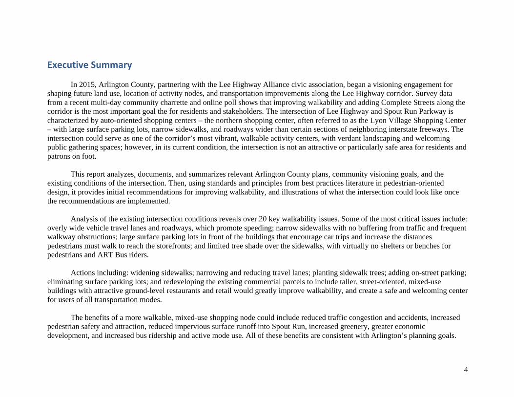
In 2015, Arlington County, partnering with the Lee Highway Alliance civic association, began a visioning engagement for shaping future land use, location of activity nodes, and transportation improvements along the Lee Highway corridor. Survey data from a recent multi-day community charrette and online poll shows that improving walkability and adding Complete Streets along the corridor is the most important goal the for residents and stakeholders. The intersection of Lee Highway and Spout Run Parkway is characterized by auto-oriented shopping centers – the northern shopping center, often referred to as the Lyon Village Shopping Center – with large surface parking lots, narrow sidewalks, and roadways wider than certain sections of neighboring interstate freeways. The intersection could serve as one of the corridor’s most vibrant, walkable activity centers, with verdant landscaping and welcoming public gathering spaces; however, in its current condition, the intersection is not an attractive or particularly safe area for residents and patrons on foot.
This report analyzes, documents, and summarizes relevant Arlington County plans, community visioning goals, and the existing conditions of the intersection. Then, using standards and principles from best practices literature in pedestrian-oriented design, it provides initial recommendations for improving walkability, and illustrations of what the intersection could look like once the recommendations are implemented.
Analysis of the existing intersection conditions reveals over 20 key walkability issues. Some of the most critical issues include: overly wide vehicle travel lanes and roadways, which promote speeding; narrow sidewalks with no buffering from traffic and frequent walkway obstructions; large surface parking lots in front of the buildings that encourage car trips and increase the distances pedestrians must walk to reach the storefronts; and limited tree shade over the sidewalks, with virtually no shelters or benches for pedestrians and ART Bus riders.
Actions including: widening sidewalks; narrowing and reducing travel lanes; planting sidewalk trees; adding on-street parking; eliminating surface parking lots; and redeveloping the existing commercial parcels to include taller, street-oriented, mixed-use buildings with attractive ground-level restaurants and retail would greatly improve walkability, and create a safe and welcoming center for users of all transportation modes.
The benefits of a more walkable, mixed-use shopping node could include reduced traffic congestion and accidents, increased pedestrian safety and attraction, reduced impervious surface runoff into Spout Run, increased greenery, greater economic development, and increased bus ridership and active mode use. All of these benefits are consistent with Arlington’s planning goals.
5
Source: Google
6
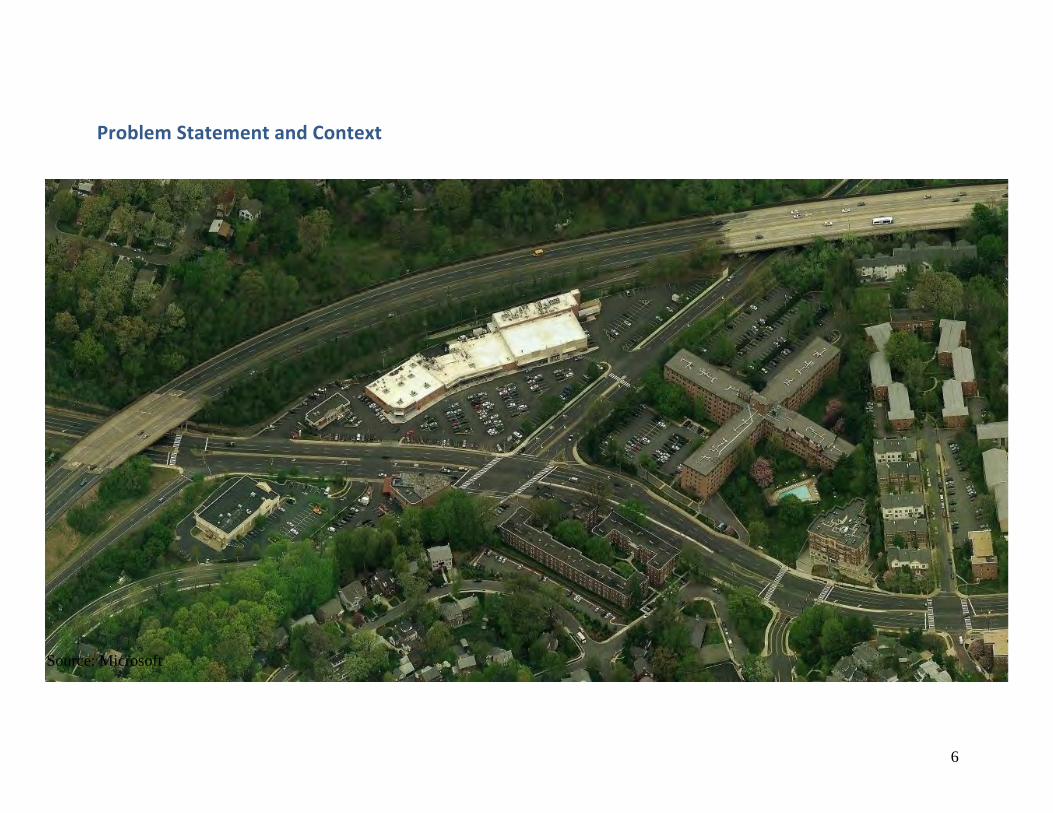
ProblemStatementandContext
Source: Microsoft
7
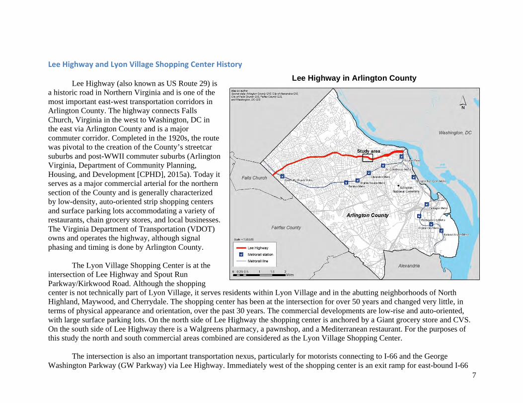
LeeHighwayandLyonVillageShoppingCenterHistory Lee Highway (also known as US Route 29) is
a historic road in Northern Virginia and is one of the most important east-west transportation corridors in Arlington County. The highway connects Falls Church, Virginia in the west to Washington, DC in the east via Arlington County and is a major commuter corridor. Completed in the 1920s, the route was pivotal to the creation of the County’s streetcar suburbs and post-WWII commuter suburbs (Arlington Virginia, Department of Community Planning, Housing, and Development [CPHD], 2015a). Today it serves as a major commercial arterial for the northern section of the County and is generally characterized by low-density, auto-oriented strip shopping centers and surface parking lots accommodating a variety of restaurants, chain grocery stores, and local businesses. The Virginia Department of Transportation (VDOT) owns and operates the highway, although signal phasing and timing is done by Arlington County.
The Lyon Village Shopping Center is at the
intersection of Lee Highway and Spout Run Parkway/Kirkwood Road. Although the shopping center is not technically part of Lyon Village, it serves residents within Lyon Village and in the abutting neighborhoods of North Highland, Maywood, and Cherrydale. The shopping center has been at the intersection for over 50 years and changed very little, in terms of physical appearance and orientation, over the past 30 years. The commercial developments are low-rise and auto-oriented, with large surface parking lots. On the north side of Lee Highway the shopping center is anchored by a Giant grocery store and CVS. On the south side of Lee Highway there is a Walgreens pharmacy, a pawnshop, and a Mediterranean restaurant. For the purposes of this study the north and south commercial areas combined are considered as the Lyon Village Shopping Center.
The intersection is also an important transportation nexus, particularly for motorists connecting to I-66 and the George
Washington Parkway (GW Parkway) via Lee Highway. Immediately west of the shopping center is an exit ramp for east-bound I-66
Lee Highway in Arlington County
8
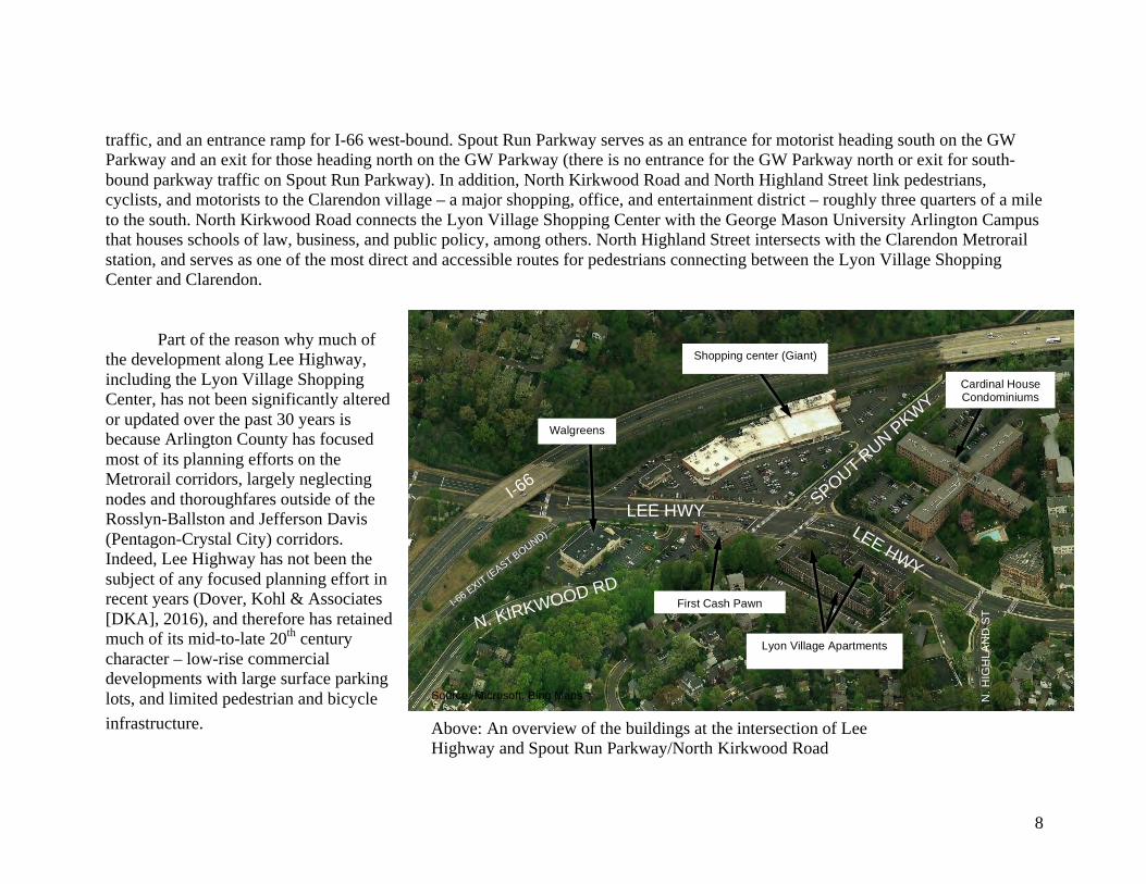
traffic, and an entrance ramp for I-66 west-bound. Spout Run Parkway serves as an entrance for motorist heading south on the GW Parkway and an exit for those heading north on the GW Parkway (there is no entrance for the GW Parkway north or exit for south-bound parkway traffic on Spout Run Parkway). In addition, North Kirkwood Road and North Highland Street link pedestrians, cyclists, and motorists to the Clarendon village – a major shopping, office, and entertainment district – roughly three quarters of a mile to the south. North Kirkwood Road connects the Lyon Village Shopping Center with the George Mason University Arlington Campus that houses schools of law, business, and public policy, among others. North Highland Street intersects with the Clarendon Metrorail station, and serves as one of the most direct and accessible routes for pedestrians connecting between the Lyon Village Shopping Center and Clarendon.
Part of the reason why much of the development along Lee Highway, including the Lyon Village Shopping Center, has not been significantly altered or updated over the past 30 years is because Arlington County has focused most of its planning efforts on the Metrorail corridors, largely neglecting nodes and thoroughfares outside of the Rosslyn-Ballston and Jefferson Davis (Pentagon-Crystal City) corridors. Indeed, Lee Highway has not been the subject of any focused planning effort in recent years (Dover, Kohl & Associates [DKA], 2016), and therefore has retained much of its mid-to-late 20th century character – low-rise commercial developments with large surface parking lots, and limited pedestrian and bicycle infrastructure.
LEE HWY SPOUT RUN PKWY
LEE HWY
N. KIRKWOOD RD
N. H
IGH
LAN
D S
T
I-66
I-66 EXIT (E
AST BOUND)
Lyon Village Apartments
First Cash Pawn
Cardinal House Condominiums
Shopping center (Giant)
Walgreens
Source: Microsoft, Bing Maps
Above: An overview of the buildings at the intersection of Lee Highway and Spout Run Parkway/North Kirkwood Road

9
LeeHighwayVisioning In February 2013, a citizen-led coalition known as the Lee
Highway Alliance (LHA) was formed to begin re-visioning Lee Highway in partnership with Arlington County. The LHA was co-founded by two Arlington citizens, Ginger Brown and Sandra Chesrown, and began moving forward with the support of 15 civic association leaders. The LHA and its partners recognized the generally outmoded nature of the Lee Highway and the development pressure from the nearby Rosslyn-Ballston corridor, and initiated their visioning effort in order to guide future development and improve upon many community goals, such as improved or increased pedestrian and bicycle access, urban design, open space, and affordable housing.
Over the next two years the LHA led several walking tours,
breakfasts, and community meetings focusing on the future planning of Lee Highway. County staff conducted a background analysis and mapping of the corridor, known as the Lee Highway Briefing Book, and in June 2015 the Lee Highway Multimodal Needs Assessment was completed for a portion of Lee Highway. In November 2015 a multi-day community visioning charrette was held to engage a broad range of residents and business owners and capture their perspectives. The results of this charrette are summarized in the February 2016 Draft Lee Highway Visioning Study.
The LHA, with community input, created a list of nine “Guiding Principles” or goals that serve as a baseline for the visioning effort. This study corresponds most closely with the second goal – “provide a complete street safe for everyone – walking, riding, biking, driving.” However, in planning for walkability, it also seeks to fulfill several of the other principles, most notably one, three, four, five, and six.
Lee Highway Alliance Guiding Principles
1. Establish a welcoming, vibrant and attractive corridor of neighborhood places
2. Provide a complete street safe for everyone – walking, riding, biking, driving
3. Enhance character through open space and community gathering places
4. Develop a low- to medium-mixed use character 5. Encourage economic vitality and sustainability 6. Encourage a range of housing choices and staying
in place 7. Promote environmental sustainability and
conservation 8. Encourage and support historic preservation 9. Maintain and promote the corridor
(Source: DKA, 2016)
10
ProblemStatementandResearchObjective Using the ongoing Lee Highway Visioning as a foundation and incentive for exploring how segments of Lee Highway could
be redesigned to meet some of the LHA Guiding Principles, the primary question this study answers is: how could the Lyon Village Shopping Center – the intersection and surrounding built environment – be transformed from an auto-oriented node into a walkable, multimodal place, while recognizing the importance of Lee Highway and Spout Run Parkway as arterial thoroughfares? This study addresses this question by providing design recommendations for the built environment and transportation facilities for creating a walkable Lyon Village Shopping Center that generally aligns with the guiding principles of the LHA. This vision can act as a guide for future public and/or private redevelopment of the sidewalks, bike paths, streets, and commercial parcels within and surrounding the shopping center.
This study focuses on a number of overlapping principles, including “walkability,” “Complete Streets,” and “Smart Growth.” There are multiple definitions for these terms, but they generally describe the same basic ideas. Walkability is a measure of how friendly an area is to walking, and takes into account the quality of pedestrian facilities, roadway conditions, land use patterns, community support, security and comfort for walking (Victoria Transport Policy Institute [VTPI], 2015a). Walkability implementation often begins with Complete Streets policies – multimodal roadway design and operating practices intended to safely accommodate pedestrians, cyclists, motorists, public transport users, and people with disabilities (VTPI, 2015b). Both walkability and Complete Streets can be considered as tools and goals within the broader strategy of Smart Growth. Arlington County defines Smart Growth as a set of ten principles that include mixing land uses, taking advantage of compact building design, creating walkable neighborhoods, and providing a variety of transportation choices (Arlington County Government, 2016).
From these definitions it is clear that there is an important relationship between land use and transportation. Indeed, Arlington County’s Master Transportation (MTP) Goals and Policies Summary notes that integrating transportation with land use and supporting the design and operation of complete streets are two general policies that “form the foundation of the MTP and, therefore, transportation in Arlington in the years ahead” (Arlington Virginia, Department of Environmental Services [DES], 2008). That is why this study will integrate both land use and transportation recommendations for improved walkability.
Walkability is also closely related to multimodal accessibility, since some cyclists, and especially transit users, often begin and end their trips on foot. In their joint publication for designing walkable urban thouroughfares the Institute of Transportation Engineers (ITE) and the Congress for the New Urbanism (CNU) state accommodating pedestrians, bicycles, transit, freight and motor vehicles, as the first principle of walkable communities (Institute of Transportation Engineers, and Congress for the New Urbanism [ITE/CNU], 2010). So, while this study primarily focuses on pedestrian-oriented designs it also considers multimodal improvements as integral for improving walkability.
11
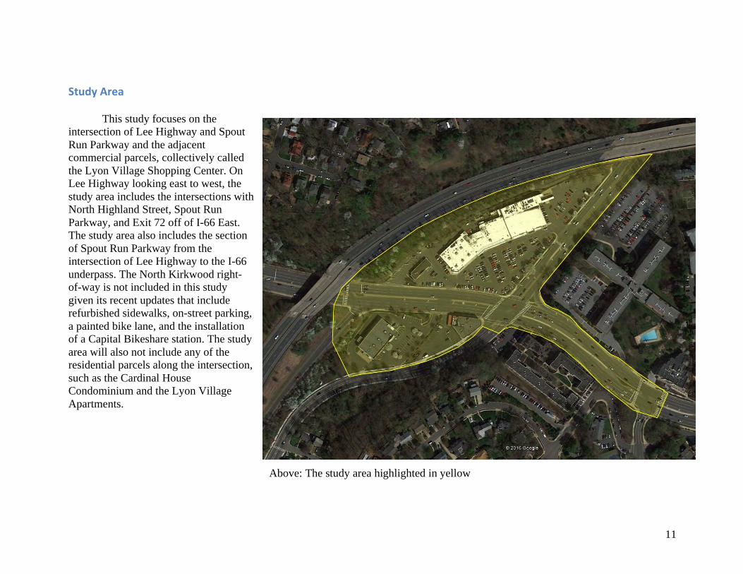
StudyArea This study focuses on the intersection of Lee Highway and Spout Run Parkway and the adjacent commercial parcels, collectively called the Lyon Village Shopping Center. On Lee Highway looking east to west, the study area includes the intersections with North Highland Street, Spout Run Parkway, and Exit 72 off of I-66 East. The study area also includes the section of Spout Run Parkway from the intersection of Lee Highway to the I-66 underpass. The North Kirkwood right-of-way is not included in this study given its recent updates that include refurbished sidewalks, on-street parking, a painted bike lane, and the installation of a Capital Bikeshare station. The study area will also not include any of the residential parcels along the intersection, such as the Cardinal House Condominium and the Lyon Village Apartments.
Above: The study area highlighted in yellow
12
SignificanceandBenefitsofaWalkableLyonVillageShoppingCenter
According to Arlington County civic engagement documents, including the Draft Lee Highway Visioning Study, Lyon Village Shopping Center has been identified as a focus area for improvements/redevelopment; however, no study or small area plan has been developed for the area, given Arlington’s focus on planning and development along the Metrorail corridors. This provides a unique opportunity for applying the best practices in planning concepts related to Smart Growth, Complete Streets, walkability, and multimodal design to an area that has remained auto-oriented for decades.
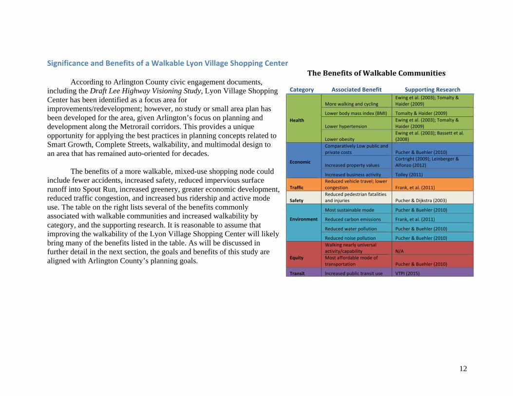
The benefits of a more walkable, mixed-use shopping node could include fewer accidents, increased safety, reduced impervious surface runoff into Spout Run, increased greenery, greater economic development, reduced traffic congestion, and increased bus ridership and active mode use. The table on the right lists several of the benefits commonly associated with walkable communities and increased walkability by category, and the supporting research. It is reasonable to assume that improving the walkability of the Lyon Village Shopping Center will likely bring many of the benefits listed in the table. As will be discussed in further detail in the next section, the goals and benefits of this study are aligned with Arlington County’s planning goals.
Category AssociatedBenefit SupportingResearch
Health
MorewalkingandcyclingEwingetal.(2003);Tomalty&Haider(2009)
Lowerbodymassindex(BMI) Tomalty&Haider(2009)
LowerhypertensionEwingetal.(2003);Tomalty&Haider(2009)
LowerobesityEwingetal.(2003);Bassettetal.(2008)
Economic
ComparativelyLowpublicandprivatecosts Pucher&Buehler(2010)
IncreasedpropertyvaluesCortright(2009);Leinberger&Alfonzo(2012)
Increasedbusinessactivity Tolley(2011)
TrafficReducedvehicletravel;lowercongestion Frank,etal.(2011)
SafetyReducedpedestrianfatalitiesandinjuries Pucher&Dijkstra(2003)
Environment
Mostsustainablemode Pucher&Buehler(2010)
Reducedcarbonemissions Frank,etal.(2011)
Reducedwaterpollution Pucher&Buehler(2010)
Reducednoisepollution Pucher&Buehler(2010)
Equity
Walkingnearlyuniversalactivity/capability N/AMostaffordablemodeoftransportation Pucher&Buehler(2010)
Transit Increasedpublictransituse VTPI(2015)
TheBenefitsofWalkableCommunities
13
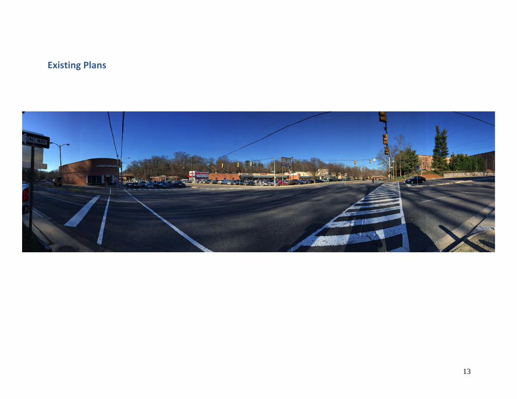
ExistingPlans
14
ArlingtonCountyPlans,Policies,andZoning
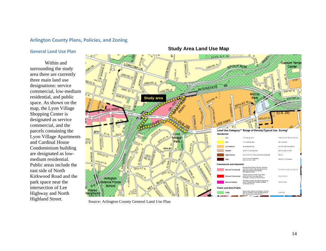
GeneralLandUsePlan
Within and surrounding the study area there are currently three main land use designations: service commercial, low-medium residential, and public space. As shown on the map, the Lyon Village Shopping Center is designated as service commercial, and the parcels containing the Lyon Village Apartments and Cardinal House Condominium building are designated as low-medium residential. Public areas include the east side of North Kirkwood Road and the park space near the intersection of Lee Highway and North Highland Street.
Study area
Source: Arlington County General Land Use Plan
Study Area Land Use Map
15
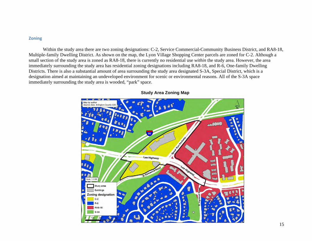
Zoning
Within the study area there are two zoning designations: C-2, Service Commercial-Community Business District, and RA8-18, Multiple-family Dwelling District. As shown on the map, the Lyon Village Shopping Center parcels are zoned for C-2. Although a small section of the study area is zoned as RA8-18, there is currently no residential use within the study area. However, the area immediately surrounding the study area has residential zoning designations including RA8-18, and R-6, One-family Dwelling Districts. There is also a substantial amount of area surrounding the study area designated S-3A, Special District, which is a designation aimed at maintaining an undeveloped environment for scenic or environmental reasons. All of the S-3A space immediately surrounding the study area is wooded, “park” space.
Study Area Zoning Map
16
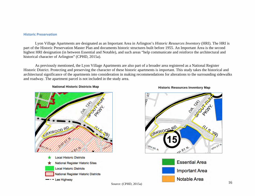
HistoricPreservation Lyon Village Apartments are designated as an Important Area in Arlington’s Historic Resources Inventory (HRI). The HRI is
part of the Historic Preservation Master Plan and documents historic structures built before 1955. An Important Area is the second highest HRI designation (in between Essential and Notable), and such areas “help communicate and reinforce the architectural and historical character of Arlington” (CPHD, 2015a).
As previously mentioned, the Lyon Village Apartments are also part of a broader area registered as a National Register
Historic District. Protecting and preserving the character of these historic apartments is important. This study takes the historical and architectural significance of the apartments into consideration in making recommendations for alterations to the surrounding sidewalks and roadway. The apartment parcel is not included in the study area.
National Historic Districts Map Historic Resources Inventory Map
Source: (CPHD, 2015a)
17
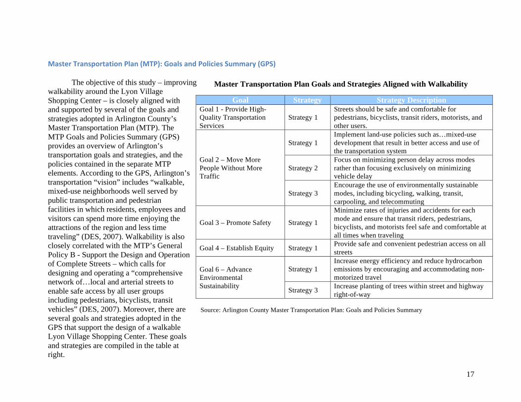
MasterTransportationPlan(MTP):GoalsandPoliciesSummary(GPS) The objective of this study – improving
walkability around the Lyon Village Shopping Center – is closely aligned with and supported by several of the goals and strategies adopted in Arlington County’s Master Transportation Plan (MTP). The MTP Goals and Policies Summary (GPS) provides an overview of Arlington’s transportation goals and strategies, and the policies contained in the separate MTP elements. According to the GPS, Arlington’s transportation “vision” includes “walkable, mixed-use neighborhoods well served by public transportation and pedestrian facilities in which residents, employees and visitors can spend more time enjoying the attractions of the region and less time traveling” (DES, 2007). Walkability is also closely correlated with the MTP’s General Policy B - Support the Design and Operation of Complete Streets – which calls for designing and operating a “comprehensive network of…local and arterial streets to enable safe access by all user groups including pedestrians, bicyclists, transit vehicles” (DES, 2007). Moreover, there are several goals and strategies adopted in the GPS that support the design of a walkable Lyon Village Shopping Center. These goals and strategies are compiled in the table at right.
Goal Strategy Strategy Description Goal 1 - Provide High-Quality Transportation Services
Strategy 1 Streets should be safe and comfortable for pedestrians, bicyclists, transit riders, motorists, and other users.
Goal 2 – Move More People Without More Traffic
Strategy 1 Implement land-use policies such as…mixed-use development that result in better access and use of the transportation system
Strategy 2 Focus on minimizing person delay across modes rather than focusing exclusively on minimizing vehicle delay
Strategy 3 Encourage the use of environmentally sustainable modes, including bicycling, walking, transit, carpooling, and telecommuting
Goal 3 – Promote Safety Strategy 1
Minimize rates of injuries and accidents for each mode and ensure that transit riders, pedestrians, bicyclists, and motorists feel safe and comfortable at all times when traveling
Goal 4 – Establish Equity Strategy 1 Provide safe and convenient pedestrian access on all streets
Goal 6 – Advance Environmental Sustainability
Strategy 1 Increase energy efficiency and reduce hydrocarbon emissions by encouraging and accommodating non-motorized travel
Strategy 3 Increase planting of trees within street and highway right-of-way
Source: Arlington County Master Transportation Plan: Goals and Policies Summary
Master Transportation Plan Goals and Strategies Aligned with Walkability
18
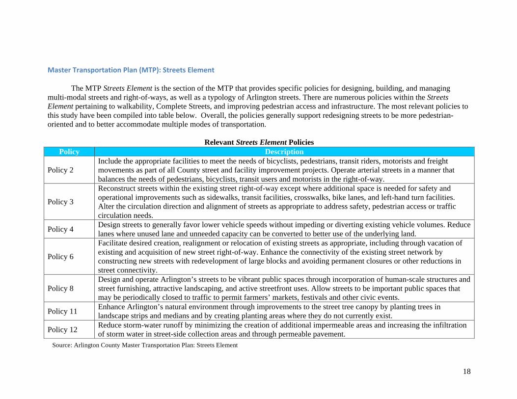
MasterTransportationPlan(MTP):StreetsElement
The MTP Streets Element is the section of the MTP that provides specific policies for designing, building, and managing multi-modal streets and right-of-ways, as well as a typology of Arlington streets. There are numerous policies within the Streets Element pertaining to walkability, Complete Streets, and improving pedestrian access and infrastructure. The most relevant policies to this study have been compiled into table below. Overall, the policies generally support redesigning streets to be more pedestrian-oriented and to better accommodate multiple modes of transportation.
Relevant Streets Element Policies
Policy Description
Policy 2 Include the appropriate facilities to meet the needs of bicyclists, pedestrians, transit riders, motorists and freight movements as part of all County street and facility improvement projects. Operate arterial streets in a manner that balances the needs of pedestrians, bicyclists, transit users and motorists in the right-of-way.
Policy 3
Reconstruct streets within the existing street right-of-way except where additional space is needed for safety and operational improvements such as sidewalks, transit facilities, crosswalks, bike lanes, and left-hand turn facilities. Alter the circulation direction and alignment of streets as appropriate to address safety, pedestrian access or traffic circulation needs.
Policy 4 Design streets to generally favor lower vehicle speeds without impeding or diverting existing vehicle volumes. Reduce lanes where unused lane and unneeded capacity can be converted to better use of the underlying land.
Policy 6
Facilitate desired creation, realignment or relocation of existing streets as appropriate, including through vacation of existing and acquisition of new street right-of-way. Enhance the connectivity of the existing street network by constructing new streets with redevelopment of large blocks and avoiding permanent closures or other reductions in street connectivity.
Policy 8 Design and operate Arlington’s streets to be vibrant public spaces through incorporation of human-scale structures and street furnishing, attractive landscaping, and active streetfront uses. Allow streets to be important public spaces that may be periodically closed to traffic to permit farmers’ markets, festivals and other civic events.
Policy 11 Enhance Arlington’s natural environment through improvements to the street tree canopy by planting trees in landscape strips and medians and by creating planting areas where they do not currently exist.
Policy 12 Reduce storm-water runoff by minimizing the creation of additional impermeable areas and increasing the infiltration of storm water in street-side collection areas and through permeable pavement.
Source: Arlington County Master Transportation Plan: Streets Element
19
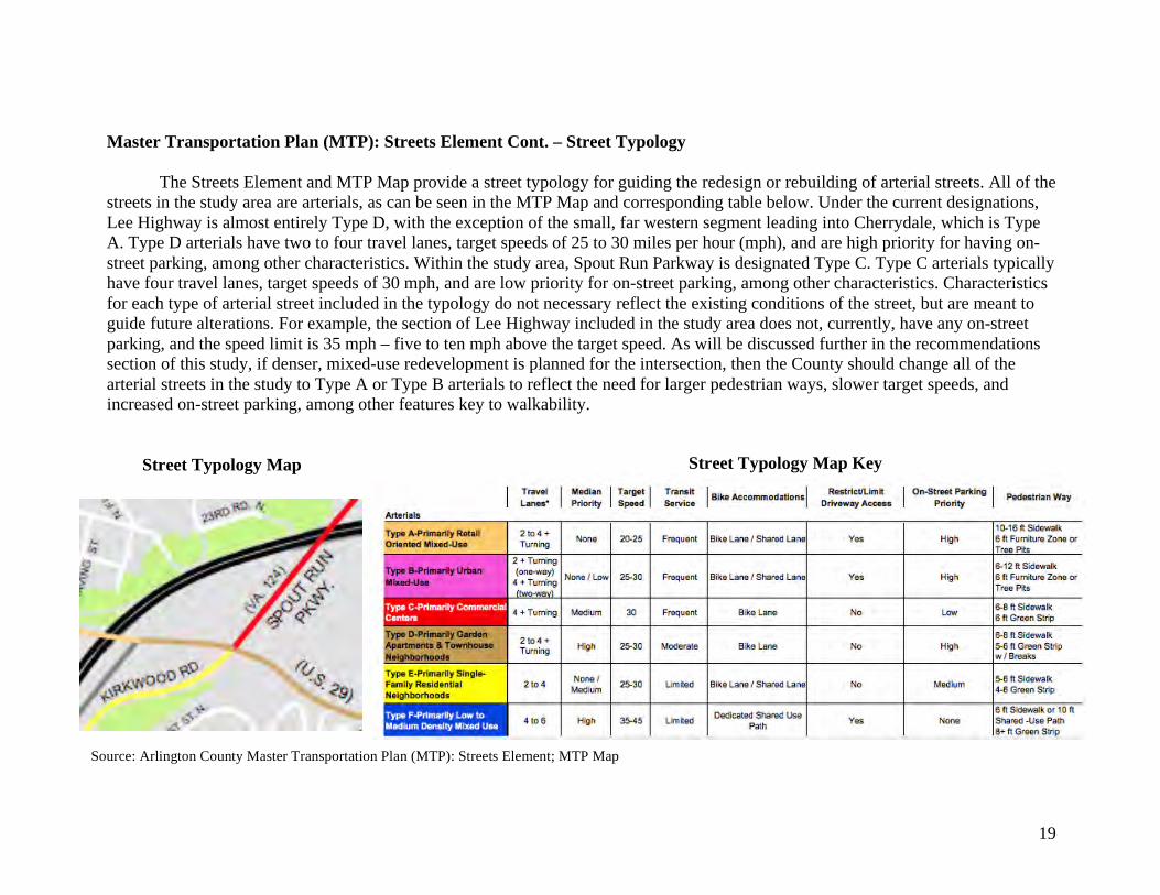
Master Transportation Plan (MTP): Streets Element Cont. – Street Typology
The Streets Element and MTP Map provide a street typology for guiding the redesign or rebuilding of arterial streets. All of the streets in the study area are arterials, as can be seen in the MTP Map and corresponding table below. Under the current designations, Lee Highway is almost entirely Type D, with the exception of the small, far western segment leading into Cherrydale, which is Type A. Type D arterials have two to four travel lanes, target speeds of 25 to 30 miles per hour (mph), and are high priority for having on-street parking, among other characteristics. Within the study area, Spout Run Parkway is designated Type C. Type C arterials typically have four travel lanes, target speeds of 30 mph, and are low priority for on-street parking, among other characteristics. Characteristics for each type of arterial street included in the typology do not necessary reflect the existing conditions of the street, but are meant to guide future alterations. For example, the section of Lee Highway included in the study area does not, currently, have any on-street parking, and the speed limit is 35 mph – five to ten mph above the target speed. As will be discussed further in the recommendations section of this study, if denser, mixed-use redevelopment is planned for the intersection, then the County should change all of the arterial streets in the study to Type A or Type B arterials to reflect the need for larger pedestrian ways, slower target speeds, and increased on-street parking, among other features key to walkability.
Source: Arlington County Master Transportation Plan (MTP): Streets Element; MTP Map
Street Typology Map Street Typology Map Key
20
MasterTransportationPlan(MTP):PedestrianElement
Perhaps the most crucial element of the MTP for this study is the Pedestrian Element. This element establishes that “Arlington would like to have more people walking to more places more often,” and that “creating a high-quality pedestrian-friendly community will be essential for Arlington to achieve its goals for mobility and environmental protection” (DES, 2008). All of the 12 policies included in the Pedestrian Element are relevant to this study; however, Policies 6 and 8 are perhaps the most significant to redesigning the arterial thoroughfares within the study area to better accommodate pedestrians. These policies read:
• Policy 6 - Use measures including street redesign and enforcement aimed at changing motorist behavior to manage
vehicular speed and minimize vehicle/pedestrian conflicts. • Policy 8 - Reconstruct arterial roadways to manage travel speeds, expand sidewalk area, improve the safety and accessibility
of pedestrian crossings and add pedestrian crossings where appropriate.
Some of the corresponding implementation actions for Policy 6 include: altering lane widths and curb return radii as part of street construction projects to manage traffic speeds and reduce the length and difficulty of pedestrian crossings, implementing traffic calming projects, and implementing special treatments such high visibility signage and markings to assist pedestrian crossing and improve safety. Some of the implementation actions for Policy 8 include: reconstructing arterial roadways to enhance sidewalks, minimize vehicle speeds in excess of the posted speed limit and pedestrian crossing distances, adjusting traffic signals to ensure that they provide adequate crossing time for safe travel by all pedestrians, and installing curb extensions to reduce pedestrian crossing distances and increase visibility for both motorists and pedestrians.
This study also takes into consideration the pedestrian accommodation and design principles that are included in the Pedestrian Element; however, additional guidelines and best practices are also used in making recommendations for the future redevelopment of the Lyon Village Shopping Center and the surrounding streetscape. Some of principles incorporated in the Pedestrian Element include standards for Americans with Disabilities Act (ADA) compliance, street tress and landscaping, and crosswalk design.
21
MasterTransportationPlan(MTP):ParkingandCurbSpaceManagement(PCSM),andBicycleElements
The Parking and Curb Space Management (PCSM) and Bicycle Elements are two separate elements of the MTP that have some relevance to the objective of this study. The PCSM provides policy guidance for both on and off-street parking, and notes that the policies support the general policy for Complete Streets (PCSM, p. 3). The Bicycle Element expands on Arlington’s vision for becoming “one of the nation’s best places to bicycle” and notes how the County’s “emphasis on mixed-use development, medium- to high-density and compact neighborhoods, creates an environment that generates many short trips where bicycling is most effective” (Bike Element, p. 2). Notably, this kind of land use development is also highly supportive of walking. The most applicable policies from these two elements are:
• PCSM, Policy 3 - Promote on-street parking within residential neighborhoods and on commercial streets to calm traffic,
support retail activity, and efficiently use public resources. • Bicycle Element, Policy 2 - Provide high-quality bicycling facilities as a part of all street improvement projects. Use marked
bicycle lanes or shared-use lane symbols (“sharrows”) on arterial streets that provide access to commercial centers, schools and government facilities.
Some of the corresponding implementation actions for PCSM Policy 3 entail: Allowing for on-street parking where street widths
and sight lines are adequate for safe travel and emergency vehicle access, and including on-street parking along both sides of streets with abutting high-density residential, retail and commercial uses. One of the key implementation actions for Bicycle Element, Policy 2 is installing bike lanes, signed bike routes, and other bicycle facilities on arterial roadways and neighborhood principal roadways in conjunction with street improvements.
22
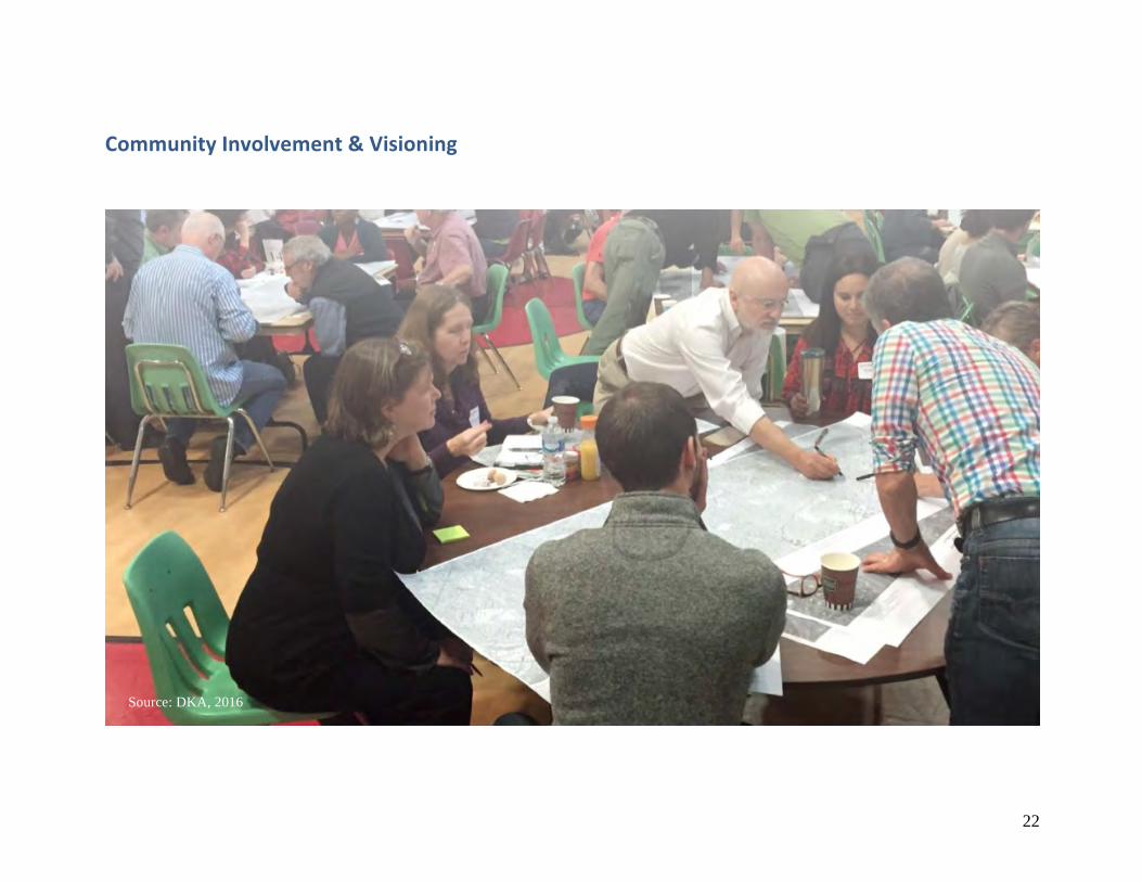
CommunityInvolvement&Visioning
Source: DKA, 2016
23
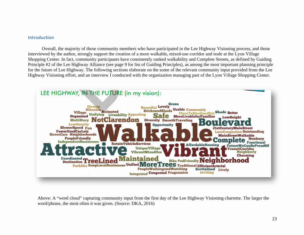
Introduction
Overall, the majority of those community members who have participated in the Lee Highway Visioning process, and those interviewed by the author, strongly support the creation of a more walkable, mixed-use corridor and node at the Lyon Village Shopping Center. In fact, community participants have consistently ranked walkability and Complete Streets, as defined by Guiding Principle #2 of the Lee Highway Alliance (see page 9 for list of Guiding Principles), as among the most important planning principle for the future of Lee Highway. The following sections elaborate on the some of the relevant community input provided from the Lee Highway Visioning effort, and an interview I conducted with the organization managing part of the Lyon Village Shopping Center.
Above: A “word cloud” capturing community input from the first day of the Lee Highway Visioning charrette. The larger the word/phrase, the most often it was given. (Source: DKA, 2016)
24
LeeHighwayVisioning:CommunityInput
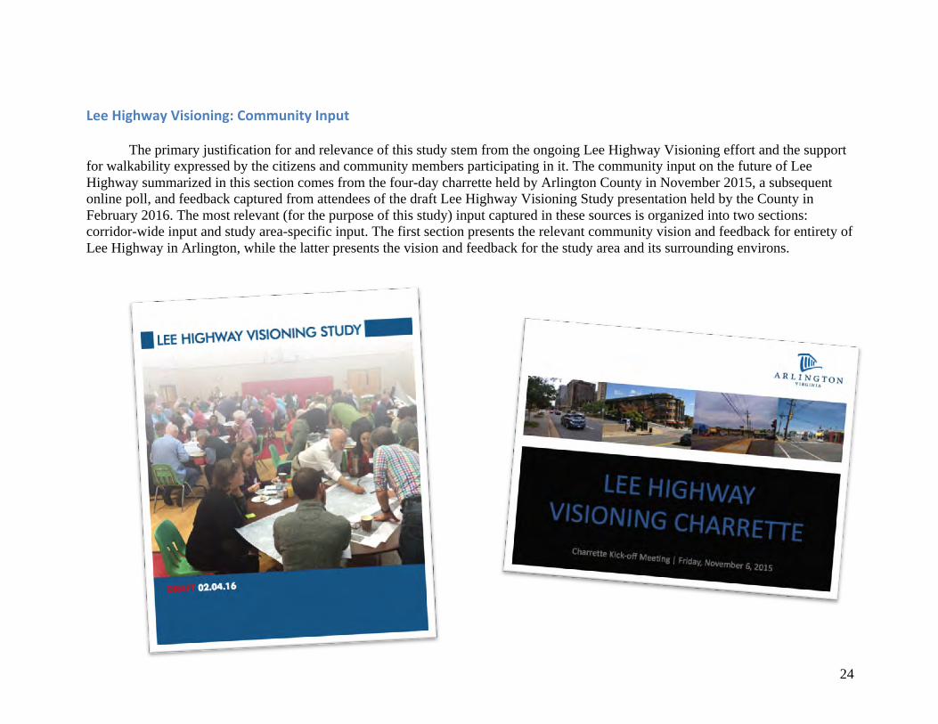
The primary justification for and relevance of this study stem from the ongoing Lee Highway Visioning effort and the support for walkability expressed by the citizens and community members participating in it. The community input on the future of Lee Highway summarized in this section comes from the four-day charrette held by Arlington County in November 2015, a subsequent online poll, and feedback captured from attendees of the draft Lee Highway Visioning Study presentation held by the County in February 2016. The most relevant (for the purpose of this study) input captured in these sources is organized into two sections: corridor-wide input and study area-specific input. The first section presents the relevant community vision and feedback for entirety of Lee Highway in Arlington, while the latter presents the vision and feedback for the study area and its surrounding environs.
25
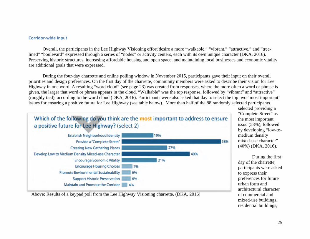
Corridor-wideInput
Overall, the participants in the Lee Highway Visioning effort desire a more “walkable,” “vibrant,” “attractive,” and “tree-lined” “boulevard” expressed through a series of “nodes” or activity centers, each with its own unique character (DKA, 2016). Preserving historic structures, increasing affordable housing and open space, and maintaining local businesses and economic vitality are additional goals that were expressed. During the four-day charrette and online polling window in November 2015, participants gave their input on their overall priorities and design preferences. On the first day of the charrette, community members were asked to describe their vision for Lee Highway in one word. A resulting “word cloud” (see page 23) was created from responses, where the more often a word or phrase is given, the larger that word or phrase appears in the cloud. “Walkable” was the top response, followed by “vibrant” and “attractive” (roughly tied), according to the word cloud (DKA, 2016). Participants were also asked that day to select the top two “most important” issues for ensuring a positive future for Lee Highway (see table below). More than half of the 88 randomly selected participants
selected providing a “Complete Street” as the most important issue (58%), followed by developing “low-to-medium density mixed-use character” (40%) (DKA, 2016).
During the first day of the charrette, participants were asked to express their preferences for future urban form and architectural character of commercial and mixed-use buildings, residential buildings,
Above: Results of a keypad poll from the Lee Highway Visioning charrette. (DKA, 2016)
26
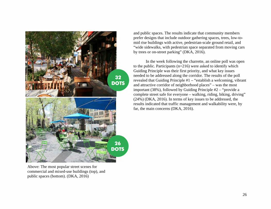
and public spaces. The results indicate that community members prefer designs that include outdoor gathering spaces, trees, low-to-mid rise buildings with active, pedestrian-scale ground retail, and “wide sidewalks, with pedestrian space separated from moving cars by trees or on-street parking” (DKA, 2016).
In the week following the charrette, an online poll was open to the public. Participants (n=216) were asked to identify which Guiding Principle was their first priority, and what key issues needed to be addressed along the corridor. The results of the poll revealed that Guiding Principle #1 – “establish a welcoming, vibrant and attractive corridor of neighborhood places” – was the most important (38%), followed by Guiding Principle #2 – “provide a complete street safe for everyone – walking, riding, biking, driving” (24%) (DKA, 2016). In terms of key issues to be addressed, the results indicated that traffic management and walkability were, by far, the main concerns (DKA, 2016).
Above: The most popular street scenes for commercial and mixed-use buildings (top), and public spaces (bottom). (DKA, 2016)
27
StudyArea-specificInput
In addition to identifying goals and concerns for the entire corridor, community members also gave input on specific sites and areas along Lee Highway, including the study area of this report. Results from the online poll asking participants to identify key concerns were grouped into common themes by area (DKA, 2016). For the Lyon Village Shopping Center and the surrounding area, the key themes included:
• Not walkable • Feels like a highway, not a neighborhood • Many apartments are dated • Big parking lots and not enough green space • I-66 is a barrier
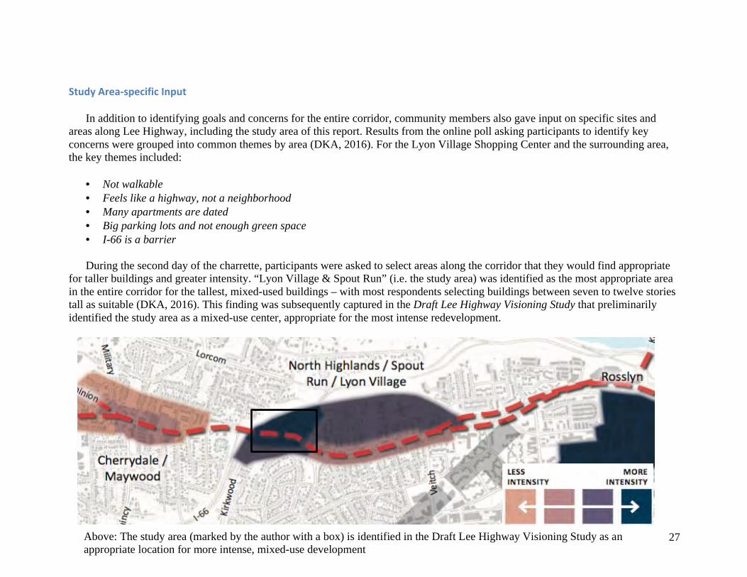
During the second day of the charrette, participants were asked to select areas along the corridor that they would find appropriate
for taller buildings and greater intensity. “Lyon Village & Spout Run” (i.e. the study area) was identified as the most appropriate area in the entire corridor for the tallest, mixed-used buildings – with most respondents selecting buildings between seven to twelve stories tall as suitable (DKA, 2016). This finding was subsequently captured in the Draft Lee Highway Visioning Study that preliminarily identified the study area as a mixed-use center, appropriate for the most intense redevelopment.
Above: The study area (marked by the author with a box) is identified in the Draft Lee Highway Visioning Study as an appropriate location for more intense, mixed-use development
28
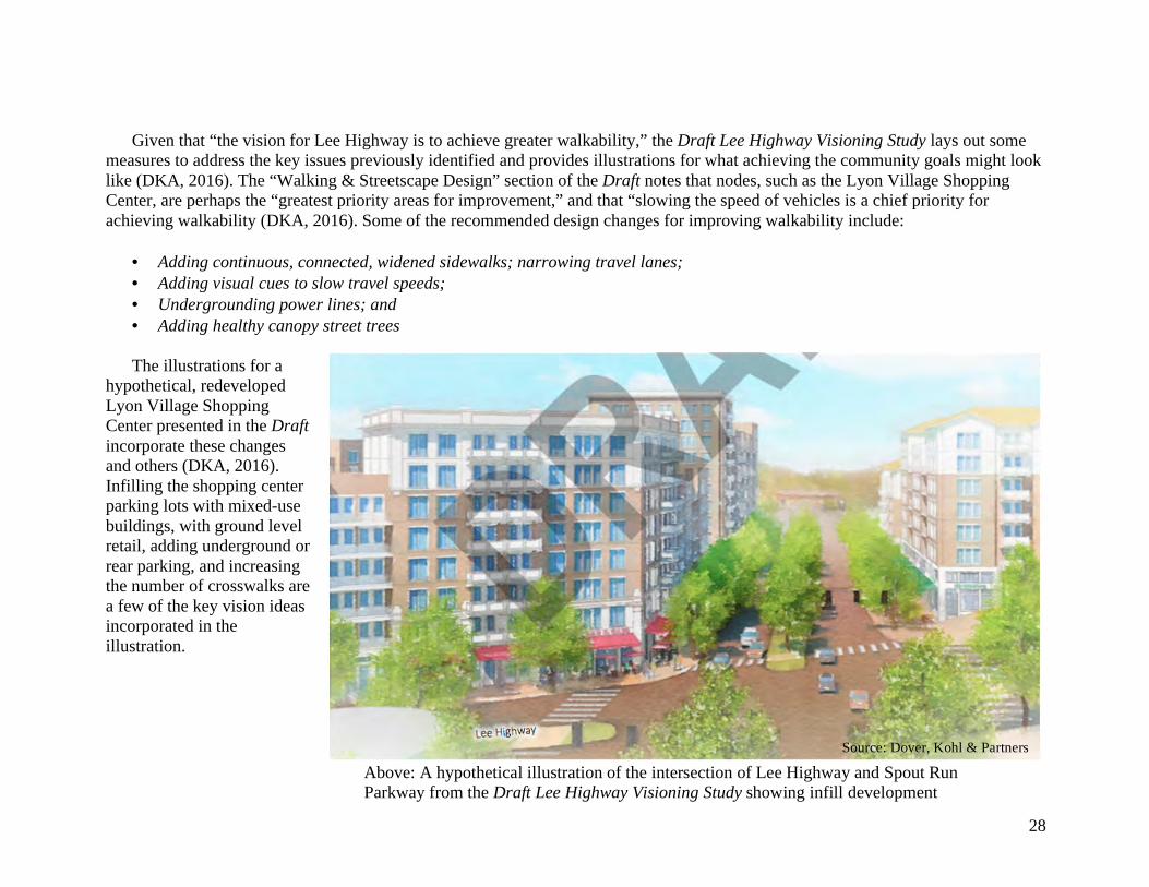
Given that “the vision for Lee Highway is to achieve greater walkability,” the Draft Lee Highway Visioning Study lays out some measures to address the key issues previously identified and provides illustrations for what achieving the community goals might look like (DKA, 2016). The “Walking & Streetscape Design” section of the Draft notes that nodes, such as the Lyon Village Shopping Center, are perhaps the “greatest priority areas for improvement,” and that “slowing the speed of vehicles is a chief priority for achieving walkability (DKA, 2016). Some of the recommended design changes for improving walkability include:
• Adding continuous, connected, widened sidewalks; narrowing travel lanes; • Adding visual cues to slow travel speeds; • Undergrounding power lines; and • Adding healthy canopy street trees
The illustrations for a
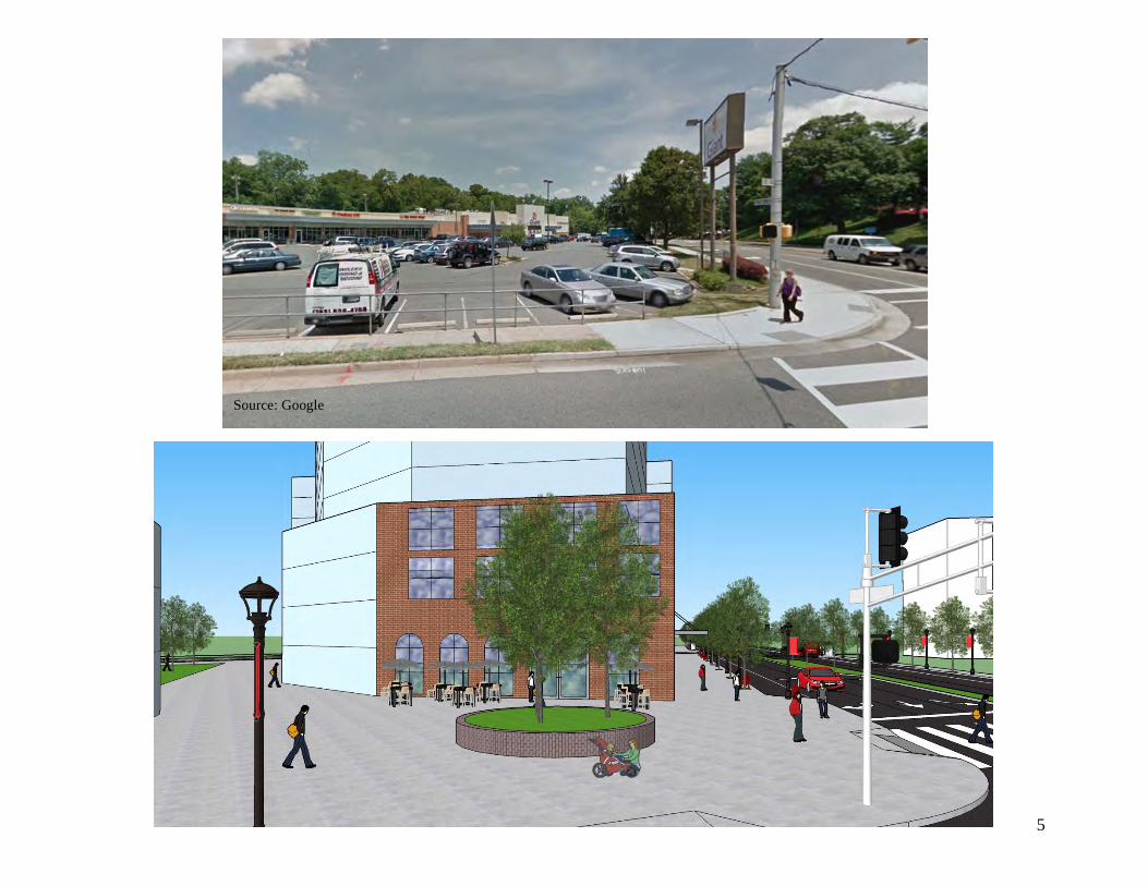
hypothetical, redeveloped Lyon Village Shopping Center presented in the Draft incorporate these changes and others (DKA, 2016). Infilling the shopping center parking lots with mixed-use buildings, with ground level retail, adding underground or rear parking, and increasing the number of crosswalks are a few of the key vision ideas incorporated in the illustration.
Source: Dover, Kohl & Partners
Above: A hypothetical illustration of the intersection of Lee Highway and Spout Run Parkway from the Draft Lee Highway Visioning Study showing infill development
29
InterviewwithBMCPropertyGroup The northern side of the Lyon Village Shopping Center (the side anchored by the Giant grocery store) is owned by the Lyon family and
managed by the BMC Property Group (BMC). In April 2016, I contacted the managing organization to capture their perspective on walkability, the Lee Highway Visioning, and the possibility of mixed-use redevelopment of the shopping center. Through email correspondence, Michele Horowitz Cornwell, Vice President of BMC, shared with me the organization’s preliminary thoughts. The following paragraphs summarize her response. BMC has been actively involved in the Lee Highway Visioning, and agrees “new, mixed-use buildings provide the best way to achieve goals such as more housing, inviting streetscapes and improved pedestrian safety.” For the foreseeable future, likely more than a decade, the group plans to keep the center’s existing layout. However, recognizing that the traditional retail center may one day become obsolete and because of the mounting pressure from e-commerce, redevelopment would be considered. BMC finds that “mixed-use development offers the best opportunity to maintain a vibrant, community-oriented, retail mix in an economically viable project.” In addition, they note that mixed-use development would be contingent on achieving enough density to offset the cost of demolition and underground parking construction. In this case, they believe residential and retail would be the most appropriate uses for the site and the community. In terms of making walkability improvements to the existing shopping center, BMC recognizes the difficulty pedestrians face in crossing Lee Highway and Spout Run Parkway and are ready to work with Arlington County on certain issues. For example, they note that they are “looking at improving entry points/landing spots for pedestrians within [the] perimeter,” and that they “stand ready to work with the county on [the] issue.” In addition, they want to upgrade the auto-oriented Giant monument sign on the corner of Lee Highway and Spout Run Parkway, but state that they are unable to do so under the existing zoning code. Lastly, BMC provided several items they would like the County to assist with in achieving a more walkable center. In the near future, they would like the County to “revisit the zoning code for monument signs to allow upgrades to grandfathered signs, improve pedestrian crosswalks across Lee Highway and Spout Run, [and] upgrade the existing traffic poles.” In the mid-term, BMC advises the County of the need to study the aging storm water box culverts underneath the property and in the immediate vicinity. According to BMC, “moving those culverts to the perimeter of the properties will be necessary before developers can plan for underground parking, and doing so will present an opportunity to coordinate the relocation with new streetscape on both sides of Lee Highway.” Finally, in the long-term, the owners would like to see the vision from the Draft Lee Highway Visioning Study approved in a plan. More specifically, a plan “allowing the nine to twelve stories envisioned by the draft plan for [the] site,” which “would provide sufficient density to economically provide the mixed-use services that the community desires.”
30
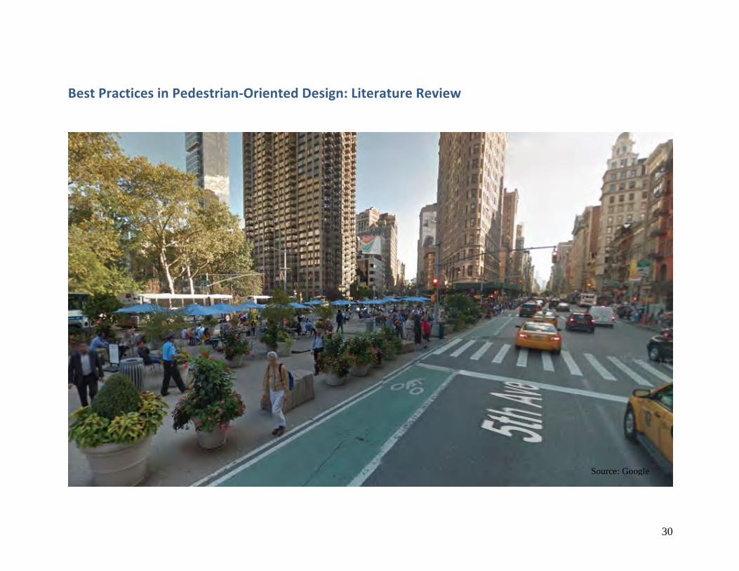
BestPracticesinPedestrian-OrientedDesign:LiteratureReview
Source: Google
31
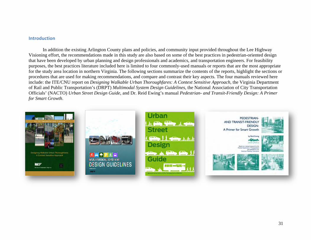
Introduction In addition the existing Arlington County plans and policies, and community input provided throughout the Lee Highway Visioning effort, the recommendations made in this study are also based on some of the best practices in pedestrian-oriented design that have been developed by urban planning and design professionals and academics, and transportation engineers. For feasibility purposes, the best practices literature included here is limited to four commonly-used manuals or reports that are the most appropriate for the study area location in northern Virginia. The following sections summarize the contents of the reports, highlight the sections or procedures that are used for making recommendations, and compare and contrast their key aspects. The four manuals reviewed here include: the ITE/CNU report on Designing Walkable Urban Thoroughfares: A Context Sensitive Approach, the Virginia Department of Rail and Public Transportation’s (DRPT) Multimodal System Design Guidelines, the National Association of City Transportation Officials’ (NACTO) Urban Street Design Guide, and Dr. Reid Ewing’s manual Pedestrian- and Transit-Friendly Design: A Primer for Smart Growth.
32
DesigningWalkableUrbanThoroughfares:AContextSensitiveApproach(ITE/CNU)
The ITE/CNU guidelines for walkable urban thoroughfares are contained in an extensive report that was developed in response to widespread interest for creating and enhancing walkable communities (ITE/CNU, 2010). Throughout thousands of years of human settlement, the report notes, urban streets preformed multiple functions, of which mobility was only one. It was not until the 20th century, and the rise of the automobile, that streets were designed, or redesigned, to separate economic and social functions from mobility functions. The intention of the ITE/CNU report is to “facilitate the restoration of the complex multiple functions of urban streets” (ITE/CNU, 2010). The report provides guidance for the “design of walkable urban thoroughfares in places that currently support the mode of walking and in places where the community desires to provide a more walkable thoroughfare, and the context to support them in the future” (ITE/CNU, 2010). The “context sensitive” approach refers to principles of context sensitive solutions (CSS), where planning is done in an inclusive, multidisciplinary fashion to meet the needs of all stakeholders, be compatible with existing settings, and respect and integrate both design objectives and community values.
The report defines walkable communities as “urban places that support walking as an important part of people’s daily travel through a complementary relationship between transportation, land use and the urban design character of the place” (ITE/CNU, 2010). Additional characteristics of walkable communities include:
• A mix of land uses in close proximity to one another; • A mix of density including relatively compact developments (both residential and commercial); • Building entries that front directly onto the sidewalk without parking between entries and the public right of way; • Building, landscape and thoroughfare design that is pedestrian-scale—in other words, that provides architectural and urban
design features scaled and detailed to be appreciated by persons who are traveling slowly and observing from the sidewalk at street level;
• Thoroughfares designed to serve the activities generated by the adjacent context in terms of the mobility, safety, access and place-making functions of the public right of way; and
• A highly connected, multimodal circulation network, usually with a fine “grain” created by relatively small blocks providing safe, continuous and balanced multimodal facilities that capitalize on compact urban development patterns and densities.
33
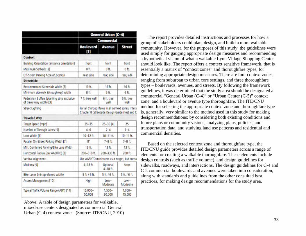
The report provides detailed instructions and processes for how a group of stakeholders could plan, design, and build a more walkable community. However, for the purposes of this study, the guidelines were used simply for gauging appropriate design measures and recommending a hypothetical vision of what a walkable Lyon Village Shopping Center should look like. The report offers a context sensitive framework, that is essentially a matrix of “context zones” and thoroughfare types, for determining appropriate design measures. There are four context zones, ranging from suburban to urban core settings, and three thoroughfare types – boulevards, avenues, and streets. By following the framework guidelines, it was determined that the study area should be designated a commercial “General Urban (C-4)” or “Urban Center (C-5)” context zone, and a boulevard or avenue type thoroughfare. The ITE/CNU method for selecting the appropriate context zone and thoroughfare type is, generally, very similar to the method used in this study for making design recommendations: by considering both existing conditions and future plans or community visions, analyzing plans, policies, and transportation data, and studying land use patterns and residential and commercial densities.
Based on the selected context zone and thoroughfare type, the ITE/CNU guide provides detailed design parameters across a range of elements for creating a walkable thoroughfare. These elements include design controls (such as traffic volume), and design guidelines for sidewalks, roadways, and intersections. The design guidelines for C-4 and C-5 commercial boulevards and avenues were taken into consideration, along with standards and guidelines from the other consulted best practices, for making design recommendations for the study area.
Above: A table of design parameters for walkable, mixed-use centers designated as commercial General Urban (C-4) context zones. (Source: ITE/CNU, 2010)
34
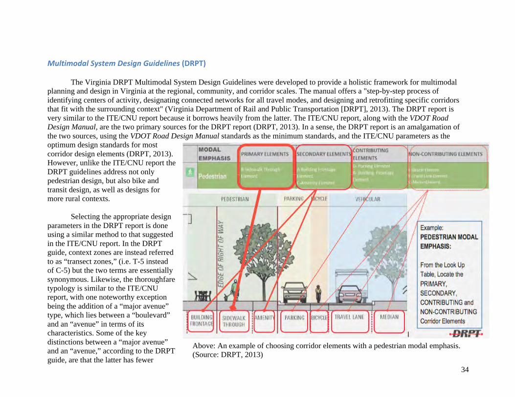
MultimodalSystemDesignGuidelines(DRPT) The Virginia DRPT Multimodal System Design Guidelines were developed to provide a holistic framework for multimodal planning and design in Virginia at the regional, community, and corridor scales. The manual offers a "step-by-step process of identifying centers of activity, designating connected networks for all travel modes, and designing and retrofitting specific corridors that fit with the surrounding context" (Virginia Department of Rail and Public Transportation [DRPT], 2013). The DRPT report is very similar to the ITE/CNU report because it borrows heavily from the latter. The ITE/CNU report, along with the VDOT Road Design Manual, are the two primary sources for the DRPT report (DRPT, 2013). In a sense, the DRPT report is an amalgamation of the two sources, using the VDOT Road Design Manual standards as the minimum standards, and the ITE/CNU parameters as the optimum design standards for most corridor design elements (DRPT, 2013). However, unlike the ITE/CNU report the DRPT guidelines address not only pedestrian design, but also bike and transit design, as well as designs for more rural contexts.
Selecting the appropriate design parameters in the DRPT report is done using a similar method to that suggested in the ITE/CNU report. In the DRPT guide, context zones are instead referred to as “transect zones,” (i.e. T-5 instead of C-5) but the two terms are essentially synonymous. Likewise, the thoroughfare typology is similar to the ITE/CNU report, with one noteworthy exception being the addition of a “major avenue” type, which lies between a “boulevard” and an “avenue” in terms of its characteristics. Some of the key distinctions between a “major avenue” and an “avenue,” according to the DRPT guide, are that the latter has fewer
Above: An example of choosing corridor elements with a pedestrian modal emphasis. (Source: DRPT, 2013)
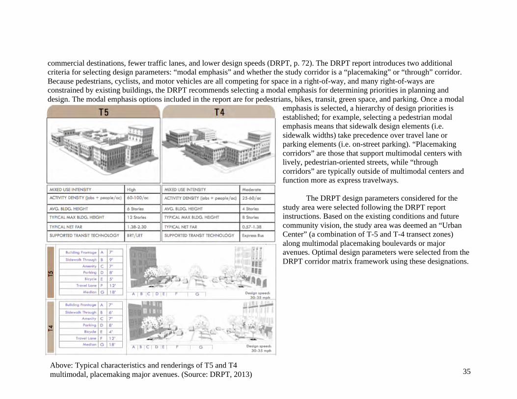
35
commercial destinations, fewer traffic lanes, and lower design speeds (DRPT, p. 72). The DRPT report introduces two additional criteria for selecting design parameters: “modal emphasis” and whether the study corridor is a “placemaking” or “through” corridor. Because pedestrians, cyclists, and motor vehicles are all competing for space in a right-of-way, and many right-of-ways are constrained by existing buildings, the DRPT recommends selecting a modal emphasis for determining priorities in planning and design. The modal emphasis options included in the report are for pedestrians, bikes, transit, green space, and parking. Once a modal
emphasis is selected, a hierarchy of design priorities is established; for example, selecting a pedestrian modal emphasis means that sidewalk design elements (i.e. sidewalk widths) take precedence over travel lane or parking elements (i.e. on-street parking). “Placemaking corridors” are those that support multimodal centers with lively, pedestrian-oriented streets, while “through corridors” are typically outside of multimodal centers and function more as express travelways.
The DRPT design parameters considered for the study area were selected following the DRPT report instructions. Based on the existing conditions and future community vision, the study area was deemed an “Urban Center” (a combination of T-5 and T-4 transect zones) along multimodal placemaking boulevards or major avenues. Optimal design parameters were selected from the DRPT corridor matrix framework using these designations.
Above: Typical characteristics and renderings of T5 and T4 multimodal, placemaking major avenues. (Source: DRPT, 2013)
36
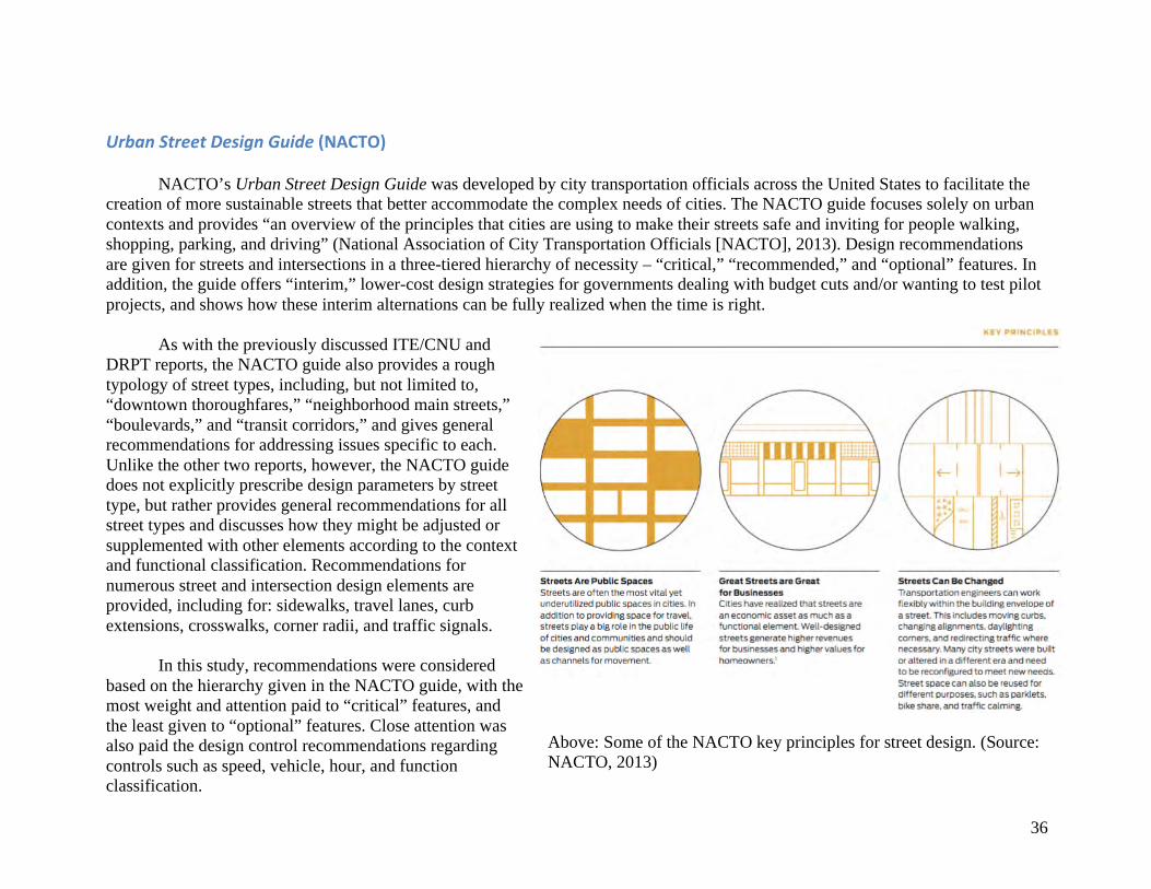
UrbanStreetDesignGuide(NACTO) NACTO’s Urban Street Design Guide was developed by city transportation officials across the United States to facilitate the creation of more sustainable streets that better accommodate the complex needs of cities. The NACTO guide focuses solely on urban contexts and provides “an overview of the principles that cities are using to make their streets safe and inviting for people walking, shopping, parking, and driving” (National Association of City Transportation Officials [NACTO], 2013). Design recommendations are given for streets and intersections in a three-tiered hierarchy of necessity – “critical,” “recommended,” and “optional” features. In addition, the guide offers “interim,” lower-cost design strategies for governments dealing with budget cuts and/or wanting to test pilot projects, and shows how these interim alternations can be fully realized when the time is right.
As with the previously discussed ITE/CNU and DRPT reports, the NACTO guide also provides a rough typology of street types, including, but not limited to, “downtown thoroughfares,” “neighborhood main streets,” “boulevards,” and “transit corridors,” and gives general recommendations for addressing issues specific to each. Unlike the other two reports, however, the NACTO guide does not explicitly prescribe design parameters by street type, but rather provides general recommendations for all street types and discusses how they might be adjusted or supplemented with other elements according to the context and functional classification. Recommendations for numerous street and intersection design elements are provided, including for: sidewalks, travel lanes, curb extensions, crosswalks, corner radii, and traffic signals. In this study, recommendations were considered based on the hierarchy given in the NACTO guide, with the most weight and attention paid to “critical” features, and the least given to “optional” features. Close attention was also paid the design control recommendations regarding controls such as speed, vehicle, hour, and function classification.
Above: Some of the NACTO key principles for street design. (Source: NACTO, 2013)
37
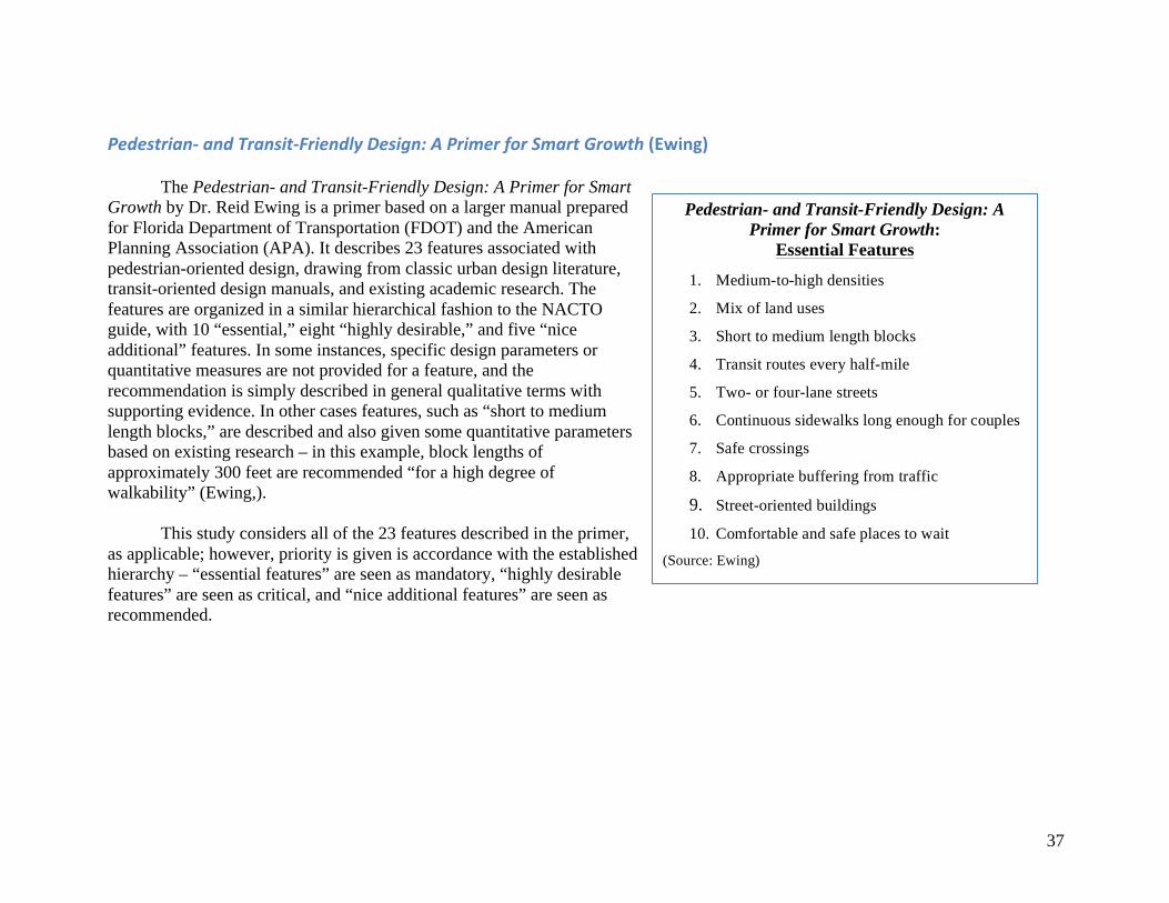
Pedestrian-andTransit-FriendlyDesign:APrimerforSmartGrowth(Ewing) The Pedestrian- and Transit-Friendly Design: A Primer for Smart Growth by Dr. Reid Ewing is a primer based on a larger manual prepared for Florida Department of Transportation (FDOT) and the American Planning Association (APA). It describes 23 features associated with pedestrian-oriented design, drawing from classic urban design literature, transit-oriented design manuals, and existing academic research. The features are organized in a similar hierarchical fashion to the NACTO guide, with 10 “essential,” eight “highly desirable,” and five “nice additional” features. In some instances, specific design parameters or quantitative measures are not provided for a feature, and the recommendation is simply described in general qualitative terms with supporting evidence. In other cases features, such as “short to medium length blocks,” are described and also given some quantitative parameters based on existing research – in this example, block lengths of approximately 300 feet are recommended “for a high degree of walkability” (Ewing,).
This study considers all of the 23 features described in the primer, as applicable; however, priority is given is accordance with the established hierarchy – “essential features” are seen as mandatory, “highly desirable features” are seen as critical, and “nice additional features” are seen as recommended.
Pedestrian- and Transit-Friendly Design: A Primer for Smart Growth:
Essential Features
1. Medium-to-high densities
2. Mix of land uses
3. Short to medium length blocks
4. Transit routes every half-mile
5. Two- or four-lane streets
6. Continuous sidewalks long enough for couples
7. Safe crossings
8. Appropriate buffering from traffic
9. Street-oriented buildings 10. Comfortable and safe places to wait
(Source: Ewing)
38
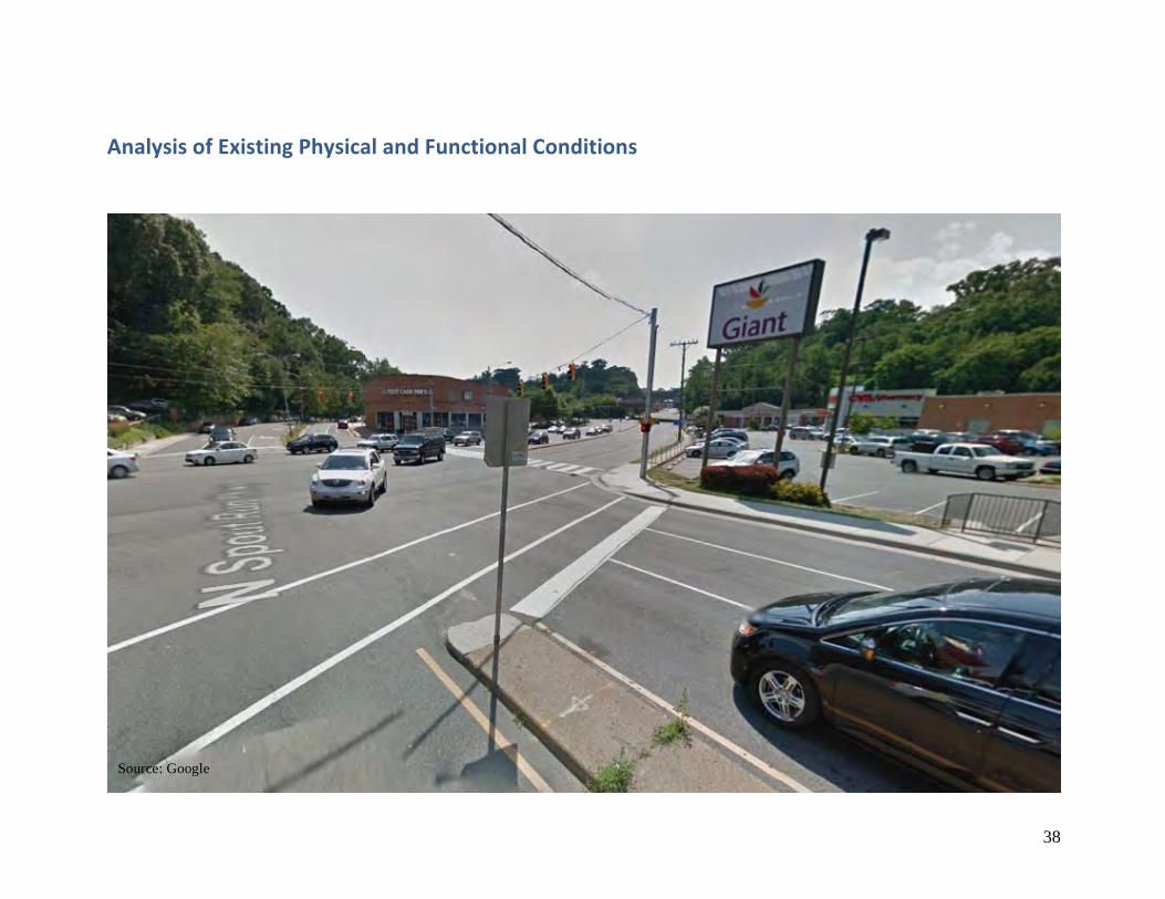
AnalysisofExistingPhysicalandFunctionalConditions
Source: Google
39
Introduction&Methodology
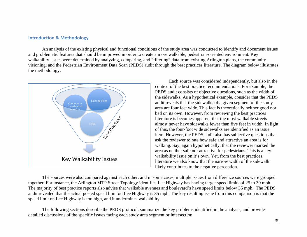
An analysis of the existing physical and functional conditions of the study area was conducted to identify and document issues and problematic features that should be improved in order to create a more walkable, pedestrian-oriented environment. Key walkability issues were determined by analyzing, comparing, and “filtering” data from existing Arlington plans, the community visioning, and the Pedestrian Environment Data Scan (PEDS) audit through the best practices literature. The diagram below illustrates the methodology:
Each source was considered independently, but also in the context of the best practice recommendations. For example, the PEDS audit consists of objective questions, such as the width of the sidewalks. As a hypothetical example, consider that the PEDS audit reveals that the sidewalks of a given segment of the study area are four feet wide. This fact is theoretically neither good nor bad on its own. However, from reviewing the best practices literature is becomes apparent that the most walkable streets almost never have sidewalks fewer than five feet in width. In light of this, the four-foot wide sidewalks are identified as an issue item. However, the PEDS audit also has subjective questions that ask the reviewer to rate how safe and attractive an area is for walking. Say, again hypothetically, that the reviewer marked the area as neither safe nor attractive for pedestrians. This is a key walkability issue on it’s own. Yet, from the best practices literature we also know that the narrow width of the sidewalk likely contributes to the negative perception.
The sources were also compared against each other, and in some cases, multiple issues from difference sources were grouped
together. For instance, the Arlington MTP Street Typology identifies Lee Highway has having target speed limits of 25 to 30 mph. The majority of best practice reports also advise that walkable avenues and boulevard’s have speed limits below 35 mph. The PEDS audit revealed that the actual posted speed limit on Lee Highway is 35 mph. The key resulting issue from this comparison is that the speed limit on Lee Highway is too high, and it undermines walkability.
The following sections describe the PEDS protocol, summarize the key problems identified in the analysis, and provide detailed discussions of the specific issues facing each study area segment or intersection.
KeyWalkabilityIssues
PEDS
CommunityInvovlement&Vision
ExistingPlansBestPractices
40
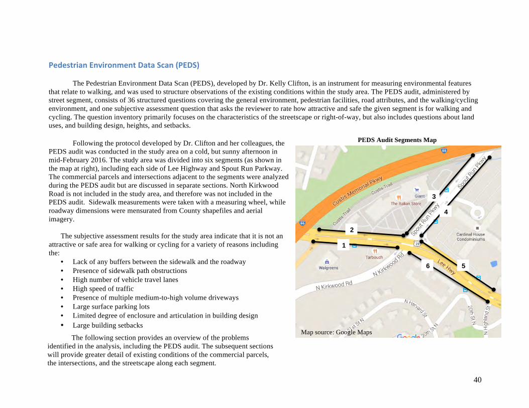
PedestrianEnvironmentDataScan(PEDS)
The Pedestrian Environment Data Scan (PEDS), developed by Dr. Kelly Clifton, is an instrument for measuring environmental features that relate to walking, and was used to structure observations of the existing conditions within the study area. The PEDS audit, administered by street segment, consists of 36 structured questions covering the general environment, pedestrian facilities, road attributes, and the walking/cycling environment, and one subjective assessment question that asks the reviewer to rate how attractive and safe the given segment is for walking and cycling. The question inventory primarily focuses on the characteristics of the streetscape or right-of-way, but also includes questions about land uses, and building design, heights, and setbacks. Following the protocol developed by Dr. Clifton and her colleagues, the PEDS audit was conducted in the study area on a cold, but sunny afternoon in mid-February 2016. The study area was divided into six segments (as shown in the map at right), including each side of Lee Highway and Spout Run Parkway. The commercial parcels and intersections adjacent to the segments were analyzed during the PEDS audit but are discussed in separate sections. North Kirkwood Road is not included in the study area, and therefore was not included in the PEDS audit. Sidewalk measurements were taken with a measuring wheel, while roadway dimensions were mensurated from County shapefiles and aerial imagery.
The subjective assessment results for the study area indicate that it is not an attractive or safe area for walking or cycling for a variety of reasons including the:
• Lack of any buffers between the sidewalk and the roadway • Presence of sidewalk path obstructions • High number of vehicle travel lanes • High speed of traffic • Presence of multiple medium-to-high volume driveways • Large surface parking lots • Limited degree of enclosure and articulation in building design • Large building setbacks
1
2
3
4
5 6
Map source: Google Maps
PEDS Audit Segments Map
The following section provides an overview of the problems identified in the analysis, including the PEDS audit. The subsequent sections will provide greater detail of existing conditions of the commercial parcels, the intersections, and the streetscape along each segment.
41
OverviewofKeyWalkabilityIssues
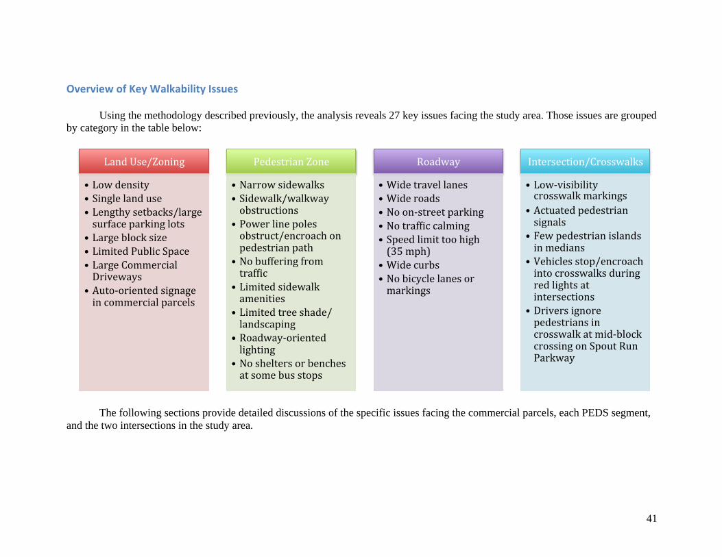
Using the methodology described previously, the analysis reveals 27 key issues facing the study area. Those issues are grouped by category in the table below:
The following sections provide detailed discussions of the specific issues facing the commercial parcels, each PEDS segment, and the two intersections in the study area.
LandUse/Zoning
• Lowdensity• Singlelanduse• Lengthysetbacks/largesurfaceparkinglots
• Largeblocksize• LimitedPublicSpace• LargeCommercialDriveways
• Auto-orientedsignageincommercialparcels
PedestrianZone
• Narrowsidewalks• Sidewalk/walkwayobstructions
• Powerlinepolesobstruct/encroachonpedestrianpath
• Nobufferingfromtrafbic
• Limitedsidewalkamenities
• Limitedtreeshade/landscaping
• Roadway-orientedlighting
• Nosheltersorbenchesatsomebusstops
Roadway
• Widetravellanes• Wideroads• Noon-streetparking• Notrafbiccalming• Speedlimittoohigh(35mph)
• Widecurbs• Nobicyclelanesormarkings
Intersection/Crosswalks
• Low-visibilitycrosswalkmarkings
• Actuatedpedestriansignals
• Fewpedestrianislandsinmedians
• Vehiclesstop/encroachintocrosswalksduringredlightsatintersections
• Driversignorepedestriansincrosswalkatmid-blockcrossingonSpoutRunParkway
42
CommercialParcels
LyonVillageShoppingCenter–North
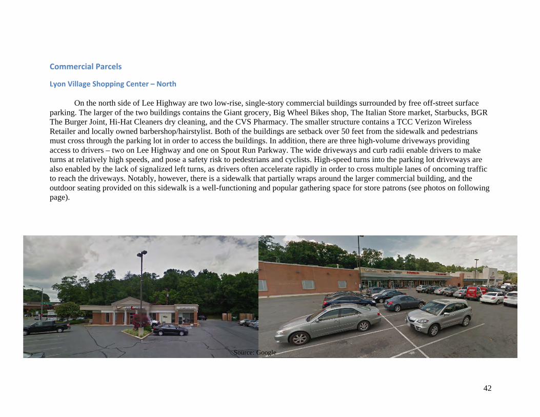
On the north side of Lee Highway are two low-rise, single-story commercial buildings surrounded by free off-street surface parking. The larger of the two buildings contains the Giant grocery, Big Wheel Bikes shop, The Italian Store market, Starbucks, BGR The Burger Joint, Hi-Hat Cleaners dry cleaning, and the CVS Pharmacy. The smaller structure contains a TCC Verizon Wireless Retailer and locally owned barbershop/hairstylist. Both of the buildings are setback over 50 feet from the sidewalk and pedestrians must cross through the parking lot in order to access the buildings. In addition, there are three high-volume driveways providing access to drivers – two on Lee Highway and one on Spout Run Parkway. The wide driveways and curb radii enable drivers to make turns at relatively high speeds, and pose a safety risk to pedestrians and cyclists. High-speed turns into the parking lot driveways are also enabled by the lack of signalized left turns, as drivers often accelerate rapidly in order to cross multiple lanes of oncoming traffic to reach the driveways. Notably, however, there is a sidewalk that partially wraps around the larger commercial building, and the outdoor seating provided on this sidewalk is a well-functioning and popular gathering space for store patrons (see photos on following page).
Source: Google

43
Source: Google
Above: sidewalk seating is popular among patrons
Source: Google
Above: wide driveways and curb radii enable higher speed turns for motorists
Right: Lyon Village Shopping Center – North
44
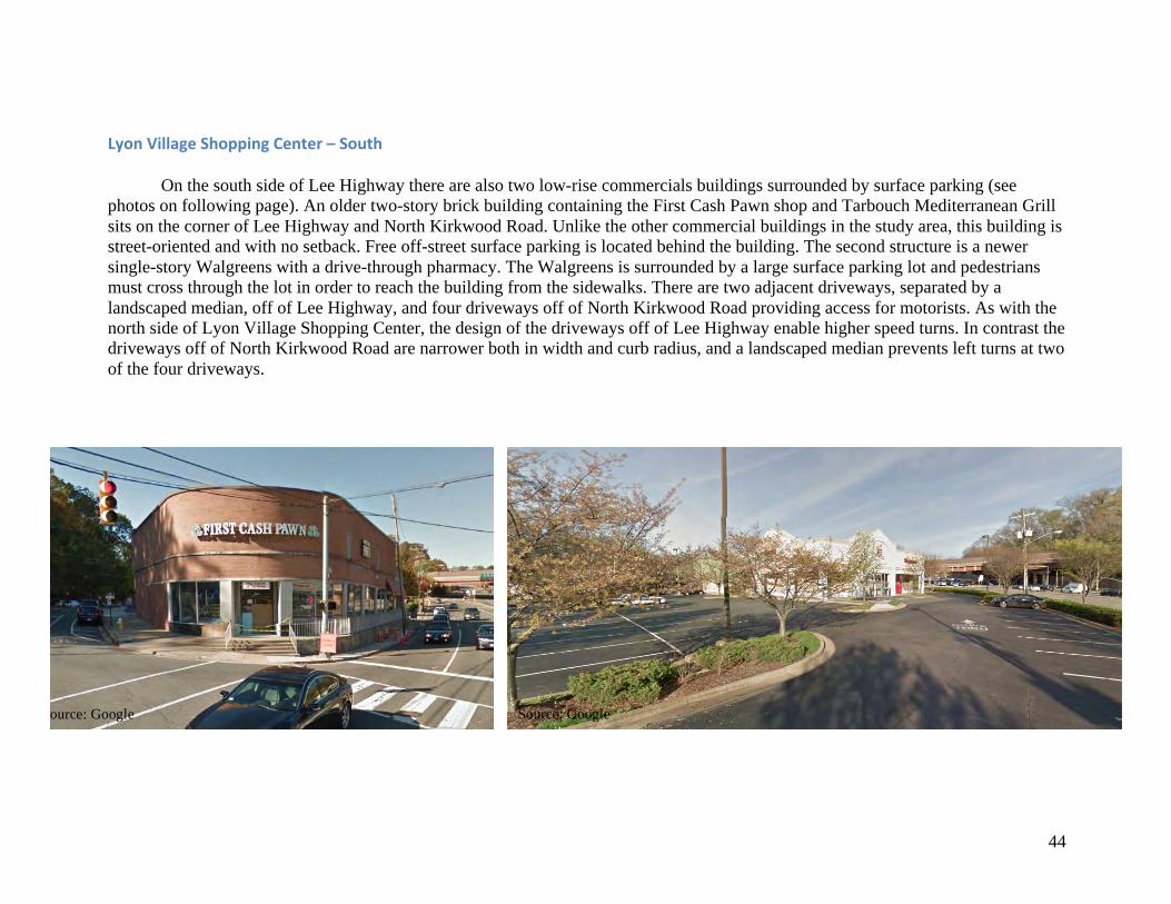
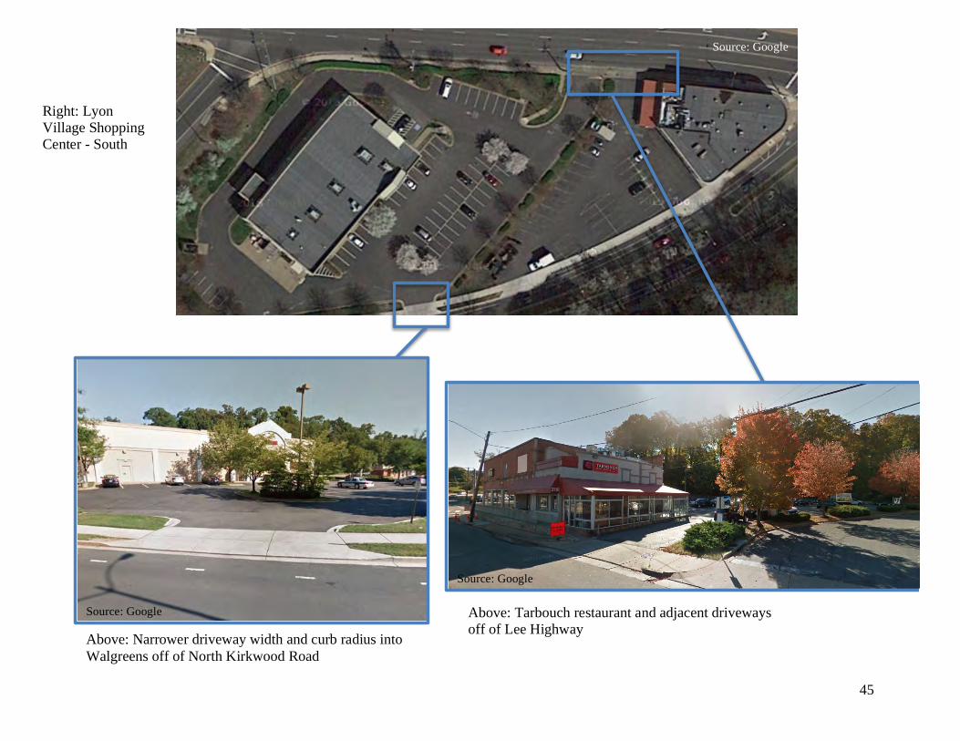
LyonVillageShoppingCenter–South
On the south side of Lee Highway there are also two low-rise commercials buildings surrounded by surface parking (see photos on following page). An older two-story brick building containing the First Cash Pawn shop and Tarbouch Mediterranean Grill sits on the corner of Lee Highway and North Kirkwood Road. Unlike the other commercial buildings in the study area, this building is street-oriented and with no setback. Free off-street surface parking is located behind the building. The second structure is a newer single-story Walgreens with a drive-through pharmacy. The Walgreens is surrounded by a large surface parking lot and pedestrians must cross through the lot in order to reach the building from the sidewalks. There are two adjacent driveways, separated by a landscaped median, off of Lee Highway, and four driveways off of North Kirkwood Road providing access for motorists. As with the north side of Lyon Village Shopping Center, the design of the driveways off of Lee Highway enable higher speed turns. In contrast the driveways off of North Kirkwood Road are narrower both in width and curb radius, and a landscaped median prevents left turns at two of the four driveways.
Source: Google Source: Google
45
Source: Google
Right: Lyon Village Shopping Center - South
Above: Tarbouch restaurant and adjacent driveways off of Lee Highway
Above: Narrower driveway width and curb radius into Walgreens off of North Kirkwood Road
Source: Google
Source: Google
46
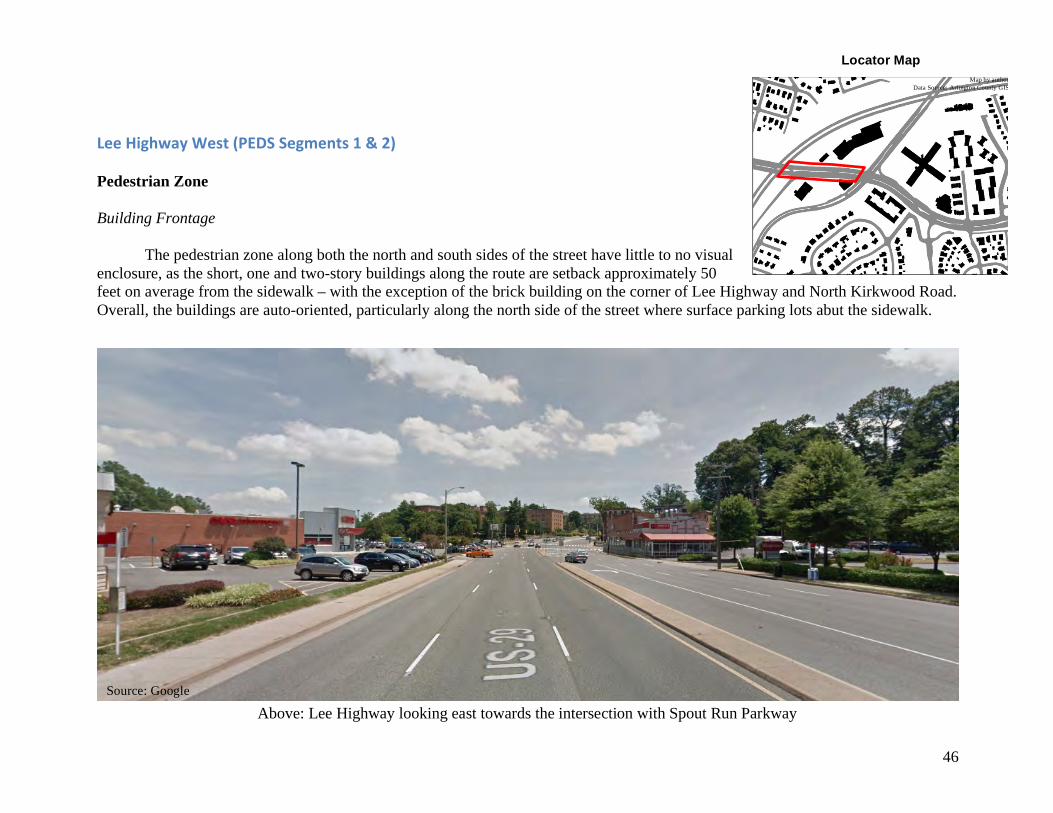
LeeHighwayWest(PEDSSegments1&2) Pedestrian Zone Building Frontage
The pedestrian zone along both the north and south sides of the street have little to no visual enclosure, as the short, one and two-story buildings along the route are setback approximately 50 feet on average from the sidewalk – with the exception of the brick building on the corner of Lee Highway and North Kirkwood Road. Overall, the buildings are auto-oriented, particularly along the north side of the street where surface parking lots abut the sidewalk.
Locator Map Map by author
Data Source: Arlington County GIS
Source: Google
Above: Lee Highway looking east towards the intersection with Spout Run Parkway
47
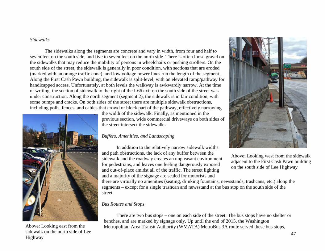
Sidewalks The sidewalks along the segments are concrete and vary in width, from four and half to seven feet on the south side, and five to seven feet on the north side. There is often loose gravel on the sidewalks that may reduce the mobility of persons in wheelchairs or pushing strollers. On the south side of the street, the sidewalk is generally in poor condition, with sections that are eroded (marked with an orange traffic cone), and low voltage power lines run the length of the segment. Along the First Cash Pawn building, the sidewalk is split-level, with an elevated ramp/pathway for handicapped access. Unfortunately, at both levels the walkway is awkwardly narrow. At the time of writing, the section of sidewalk to the right of the I-66 exit on the south side of the street was under construction. Along the north segment (segment 2), the sidewalk is in fair condition, with some bumps and cracks. On both sides of the street there are multiple sidewalk obstructions, including polls, fences, and cables that crowd or block part of the pathway, effectively narrowing
the width of the sidewalk. Finally, as mentioned in the previous section, wide commercial driveways on both sides of the street intersect the sidewalks. Buffers, Amenities, and Landscaping In addition to the relatively narrow sidewalk widths and path obstructions, the lack of any buffer between the sidewalk and the roadway creates an unpleasant environment for pedestrians, and leaves one feeling dangerously exposed and out-of-place amidst all of the traffic. The street lighting and a majority of the signage are scaled for motorists and there are virtually no amenities (seating, drinking fountains, newsstands, trashcans, etc.) along the segments – except for a single trashcan and newsstand at the bus stop on the south side of the street. Bus Routes and Stops
There are two bus stops – one on each side of the street. The bus stops have no shelter or benches, and are marked by signage only. Up until the end of 2015, the Washington Metropolitan Area Transit Authority (WMATA) MetroBus 3A route served these bus stops,
Above: Looking west from the sidewalk adjacent to the First Cash Pawn building on the south side of Lee Highway
Above: Looking east from the sidewalk on the north side of Lee Highway
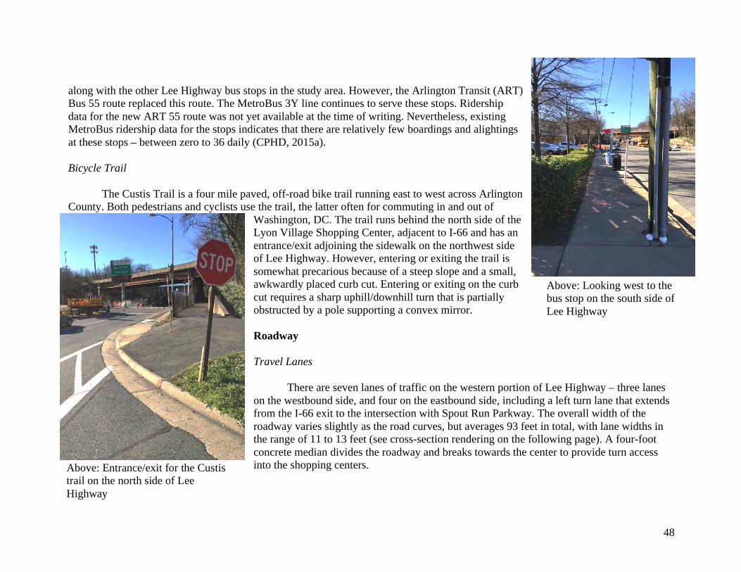
48
along with the other Lee Highway bus stops in the study area. However, the Arlington Transit (ART) Bus 55 route replaced this route. The MetroBus 3Y line continues to serve these stops. Ridership data for the new ART 55 route was not yet available at the time of writing. Nevertheless, existing MetroBus ridership data for the stops indicates that there are relatively few boardings and alightings at these stops – between zero to 36 daily (CPHD, 2015a). Bicycle Trail The Custis Trail is a four mile paved, off-road bike trail running east to west across Arlington County. Both pedestrians and cyclists use the trail, the latter often for commuting in and out of
Washington, DC. The trail runs behind the north side of the Lyon Village Shopping Center, adjacent to I-66 and has an entrance/exit adjoining the sidewalk on the northwest side of Lee Highway. However, entering or exiting the trail is somewhat precarious because of a steep slope and a small, awkwardly placed curb cut. Entering or exiting on the curb cut requires a sharp uphill/downhill turn that is partially obstructed by a pole supporting a convex mirror. Roadway Travel Lanes There are seven lanes of traffic on the western portion of Lee Highway – three lanes on the westbound side, and four on the eastbound side, including a left turn lane that extends from the I-66 exit to the intersection with Spout Run Parkway. The overall width of the roadway varies slightly as the road curves, but averages 93 feet in total, with lane widths in the range of 11 to 13 feet (see cross-section rendering on the following page). A four-foot concrete median divides the roadway and breaks towards the center to provide turn access into the shopping centers.
Above: Looking west to the bus stop on the south side of Lee Highway
Above: Entrance/exit for the Custis trail on the north side of Lee Highway
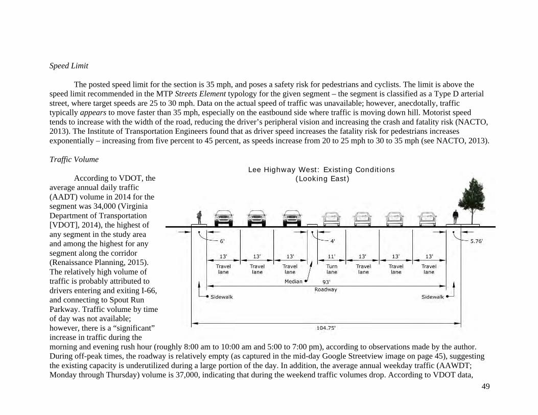
49
Speed Limit
The posted speed limit for the section is 35 mph, and poses a safety risk for pedestrians and cyclists. The limit is above the speed limit recommended in the MTP Streets Element typology for the given segment – the segment is classified as a Type D arterial street, where target speeds are 25 to 30 mph. Data on the actual speed of traffic was unavailable; however, anecdotally, traffic typically appears to move faster than 35 mph, especially on the eastbound side where traffic is moving down hill. Motorist speed tends to increase with the width of the road, reducing the driver’s peripheral vision and increasing the crash and fatality risk (NACTO, 2013). The Institute of Transportation Engineers found that as driver speed increases the fatality risk for pedestrians increases exponentially – increasing from five percent to 45 percent, as speeds increase from 20 to 25 mph to 30 to 35 mph (see NACTO, 2013). Traffic Volume
According to VDOT, the average annual daily traffic (AADT) volume in 2014 for the segment was 34,000 (Virginia Department of Transportation [VDOT], 2014), the highest of any segment in the study area and among the highest for any segment along the corridor (Renaissance Planning, 2015). The relatively high volume of traffic is probably attributed to drivers entering and exiting I-66, and connecting to Spout Run Parkway. Traffic volume by time of day was not available; however, there is a “significant” increase in traffic during the morning and evening rush hour (roughly 8:00 am to 10:00 am and 5:00 to 7:00 pm), according to observations made by the author. During off-peak times, the roadway is relatively empty (as captured in the mid-day Google Streetview image on page 45), suggesting the existing capacity is underutilized during a large portion of the day. In addition, the average annual weekday traffic (AAWDT; Monday through Thursday) volume is 37,000, indicating that during the weekend traffic volumes drop. According to VDOT data,
Lee Highway West: Existing Conditions (Looking East)
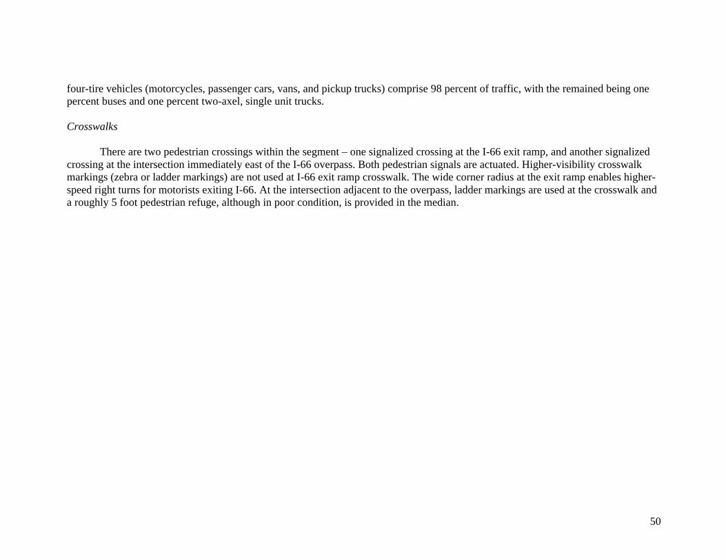
50
four-tire vehicles (motorcycles, passenger cars, vans, and pickup trucks) comprise 98 percent of traffic, with the remained being one percent buses and one percent two-axel, single unit trucks. Crosswalks
There are two pedestrian crossings within the segment – one signalized crossing at the I-66 exit ramp, and another signalized crossing at the intersection immediately east of the I-66 overpass. Both pedestrian signals are actuated. Higher-visibility crosswalk markings (zebra or ladder markings) are not used at I-66 exit ramp crosswalk. The wide corner radius at the exit ramp enables higher-speed right turns for motorists exiting I-66. At the intersection adjacent to the overpass, ladder markings are used at the crosswalk and a roughly 5 foot pedestrian refuge, although in poor condition, is provided in the median.
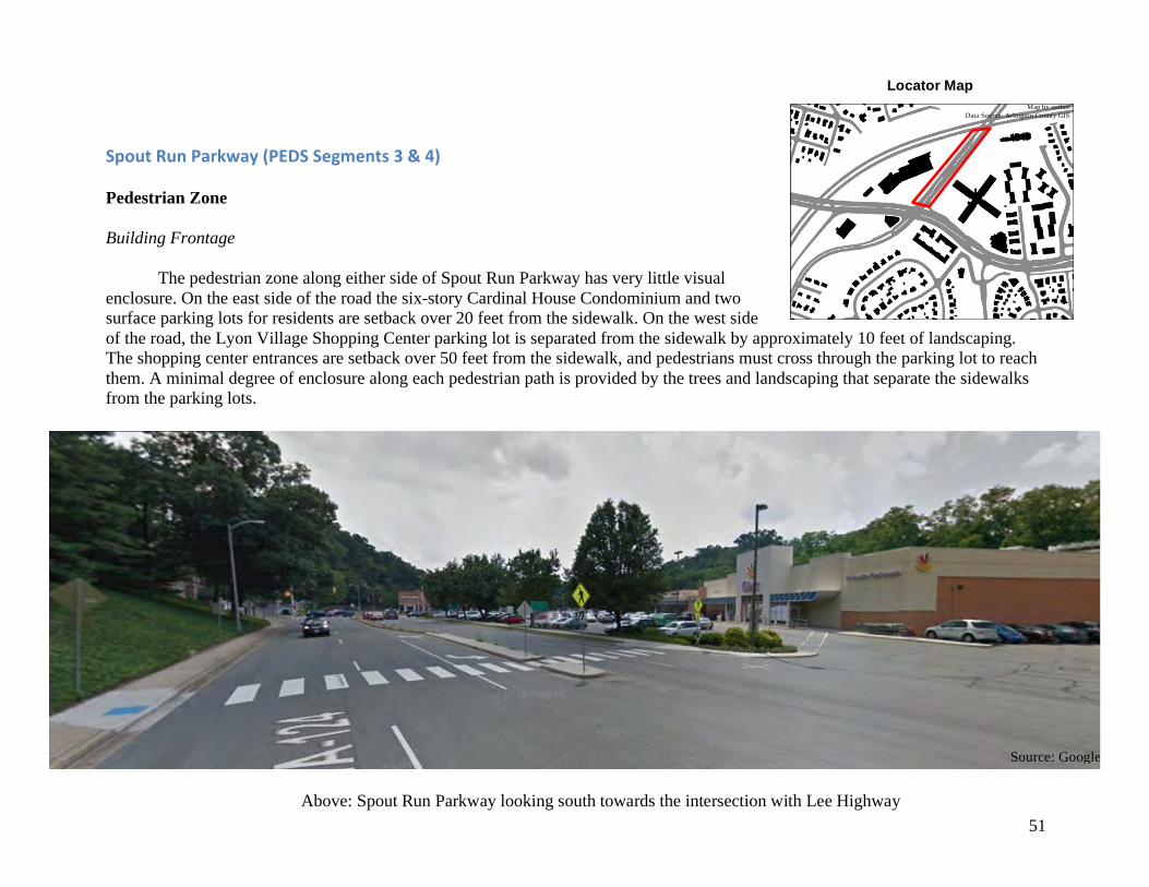
51
SpoutRunParkway(PEDSSegments3&4) Pedestrian Zone Building Frontage
The pedestrian zone along either side of Spout Run Parkway has very little visual enclosure. On the east side of the road the six-story Cardinal House Condominium and two surface parking lots for residents are setback over 20 feet from the sidewalk. On the west side of the road, the Lyon Village Shopping Center parking lot is separated from the sidewalk by approximately 10 feet of landscaping. The shopping center entrances are setback over 50 feet from the sidewalk, and pedestrians must cross through the parking lot to reach them. A minimal degree of enclosure along each pedestrian path is provided by the trees and landscaping that separate the sidewalks from the parking lots.
Locator Map Map by author
Data Source: Arlington County GIS
Source: Google
Above: Spout Run Parkway looking south towards the intersection with Lee Highway
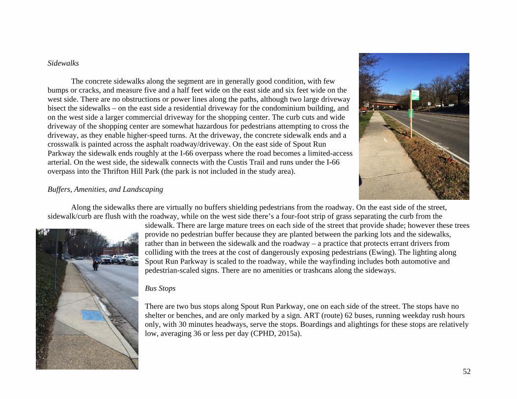
52
Sidewalks The concrete sidewalks along the segment are in generally good condition, with few bumps or cracks, and measure five and a half feet wide on the east side and six feet wide on the west side. There are no obstructions or power lines along the paths, although two large driveway bisect the sidewalks – on the east side a residential driveway for the condominium building, and on the west side a larger commercial driveway for the shopping center. The curb cuts and wide driveway of the shopping center are somewhat hazardous for pedestrians attempting to cross the driveway, as they enable higher-speed turns. At the driveway, the concrete sidewalk ends and a crosswalk is painted across the asphalt roadway/driveway. On the east side of Spout Run Parkway the sidewalk ends roughly at the I-66 overpass where the road becomes a limited-access arterial. On the west side, the sidewalk connects with the Custis Trail and runs under the I-66 overpass into the Thrifton Hill Park (the park is not included in the study area). Buffers, Amenities, and Landscaping Along the sidewalks there are virtually no buffers shielding pedestrians from the roadway. On the east side of the street, sidewalk/curb are flush with the roadway, while on the west side there’s a four-foot strip of grass separating the curb from the
sidewalk. There are large mature trees on each side of the street that provide shade; however these trees provide no pedestrian buffer because they are planted between the parking lots and the sidewalks, rather than in between the sidewalk and the roadway – a practice that protects errant drivers from colliding with the trees at the cost of dangerously exposing pedestrians (Ewing). The lighting along Spout Run Parkway is scaled to the roadway, while the wayfinding includes both automotive and pedestrian-scaled signs. There are no amenities or trashcans along the sideways. Bus Stops There are two bus stops along Spout Run Parkway, one on each side of the street. The stops have no shelter or benches, and are only marked by a sign. ART (route) 62 buses, running weekday rush hours only, with 30 minutes headways, serve the stops. Boardings and alightings for these stops are relatively low, averaging 36 or less per day (CPHD, 2015a).
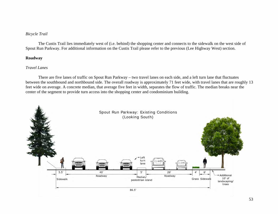
53
Bicycle Trail
The Custis Trail lies immediately west of (i.e. behind) the shopping center and connects to the sidewalk on the west side of Spout Run Parkway. For additional information on the Custis Trail please refer to the previous (Lee Highway West) section. Roadway Travel Lanes There are five lanes of traffic on Spout Run Parkway – two travel lanes on each side, and a left turn lane that fluctuates between the southbound and northbound side. The overall roadway is approximately 71 feet wide, with travel lanes that are roughly 13 feet wide on average. A concrete median, that average five feet in width, separates the flow of traffic. The median breaks near the center of the segment to provide turn access into the shopping center and condominium building.
Spout Run Parkway: Existing Conditions (Looking South)
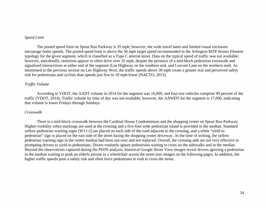
54
Speed Limit
The posted speed limit on Spout Run Parkway is 35 mph; however, the wide travel lanes and limited visual enclosure encourage faster speeds. The posted speed limit is above the 30 mph target speed recommended in the Arlington MTP Streets Element typology for the given segment, which is classified as a Type C arterial street. Data on the typical speed of traffic was not available; however, anecdotally, motorists appear to often drive over 35 mph, despite the presence of a mid-block pedestrian crosswalk and signalized intersections at either end of the segment (Lee Highway on the southern end, and Lorcom Lane on the northern end). As mentioned in the previous section on Lee Highway West, the traffic speeds above 30 mph create a greater real and perceived safety risk for pedestrians and cyclists than speeds just five to 10 mph lower (NACTO, 2013). Traffic Volume
According to VDOT, the AADT volume in 2014 for the segment was 16,000, and four-tire vehicles comprise 99 percent of the traffic (VDOT, 2014). Traffic volume by time of day was not available; however, the AAWDT for the segment is 17,000, indicating that volume is lower Fridays through Sundays. Crosswalk
There is a mid-block crosswalk between the Cardinal House Condominium and the shopping center on Spout Run Parkway. Higher-visibility zebra markings are used at the crossing and a five-foot wide pedestrian island is provided in the median. Standard yellow pedestrian warning signs (W11-2) are placed on each side of the road adjacent to the crossing, and a white “yield to pedestrian” sign is placed on the east side of the street facing the shopping center driveway. At the time of writing, the yellow pedestrian warning sign in the center median had been run over and not replaced. Overall, the crossing aids are not very effective in prompting drivers to yield to pedestrians. Divers routinely ignore pedestrians waiting to cross on the sidewalks and in the median. Beyond the observations captured during the PEDS analysis, historical Google Street View images reveal drivers ignoring a pedestrian in the median waiting to push an elderly person in a wheelchair across the street (see images on the following page). In addition, the higher traffic speeds pose a safety risk and often force pedestrians to rush to cross the street.
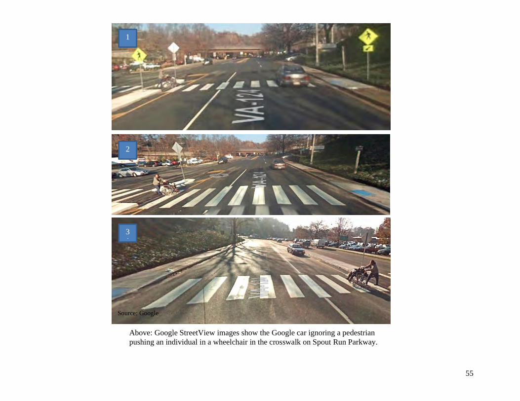
55
Above: Google StreetView images show the Google car ignoring a pedestrian pushing an individual in a wheelchair in the crosswalk on Spout Run Parkway.
Source: Google
1
2
31
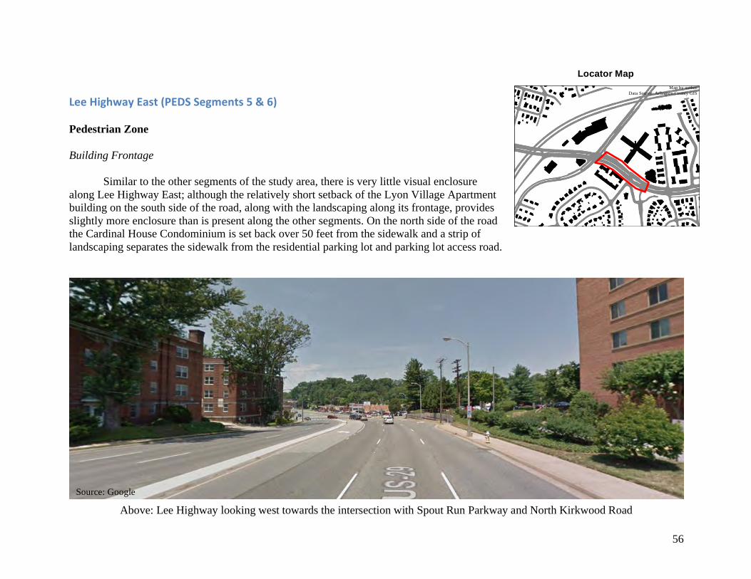
56
LeeHighwayEast(PEDSSegments5&6) Pedestrian Zone Building Frontage
Similar to the other segments of the study area, there is very little visual enclosure along Lee Highway East; although the relatively short setback of the Lyon Village Apartment building on the south side of the road, along with the landscaping along its frontage, provides slightly more enclosure than is present along the other segments. On the north side of the road the Cardinal House Condominium is set back over 50 feet from the sidewalk and a strip of landscaping separates the sidewalk from the residential parking lot and parking lot access road.
Locator Map Map by author
Data Source: Arlington County GIS
Source: Google
Above: Lee Highway looking west towards the intersection with Spout Run Parkway and North Kirkwood Road
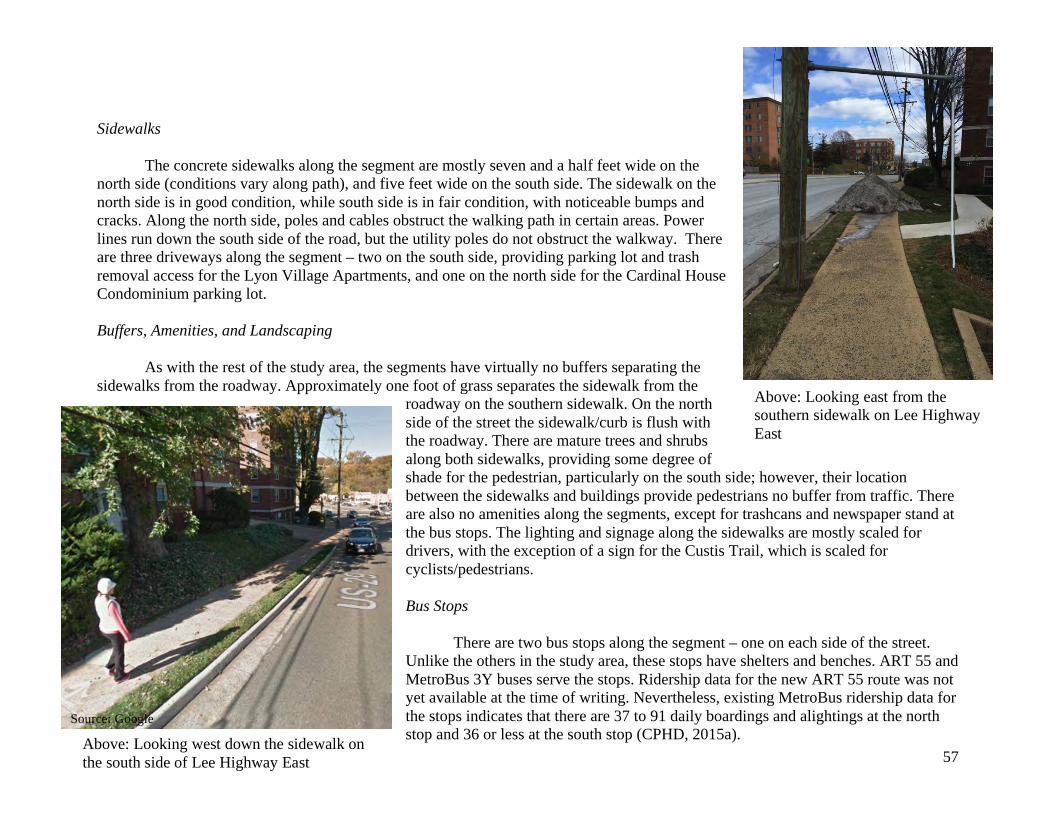
57
Sidewalks
The concrete sidewalks along the segment are mostly seven and a half feet wide on the north side (conditions vary along path), and five feet wide on the south side. The sidewalk on the north side is in good condition, while south side is in fair condition, with noticeable bumps and cracks. Along the north side, poles and cables obstruct the walking path in certain areas. Power lines run down the south side of the road, but the utility poles do not obstruct the walkway. There are three driveways along the segment – two on the south side, providing parking lot and trash removal access for the Lyon Village Apartments, and one on the north side for the Cardinal House Condominium parking lot. Buffers, Amenities, and Landscaping As with the rest of the study area, the segments have virtually no buffers separating the sidewalks from the roadway. Approximately one foot of grass separates the sidewalk from the
roadway on the southern sidewalk. On the north side of the street the sidewalk/curb is flush with the roadway. There are mature trees and shrubs along both sidewalks, providing some degree of shade for the pedestrian, particularly on the south side; however, their location between the sidewalks and buildings provide pedestrians no buffer from traffic. There are also no amenities along the segments, except for trashcans and newspaper stand at the bus stops. The lighting and signage along the sidewalks are mostly scaled for drivers, with the exception of a sign for the Custis Trail, which is scaled for cyclists/pedestrians. Bus Stops There are two bus stops along the segment – one on each side of the street. Unlike the others in the study area, these stops have shelters and benches. ART 55 and MetroBus 3Y buses serve the stops. Ridership data for the new ART 55 route was not yet available at the time of writing. Nevertheless, existing MetroBus ridership data for the stops indicates that there are 37 to 91 daily boardings and alightings at the north stop and 36 or less at the south stop (CPHD, 2015a).
Source: Google
Above: Looking east from the southern sidewalk on Lee Highway East
Above: Looking west down the sidewalk on the south side of Lee Highway East
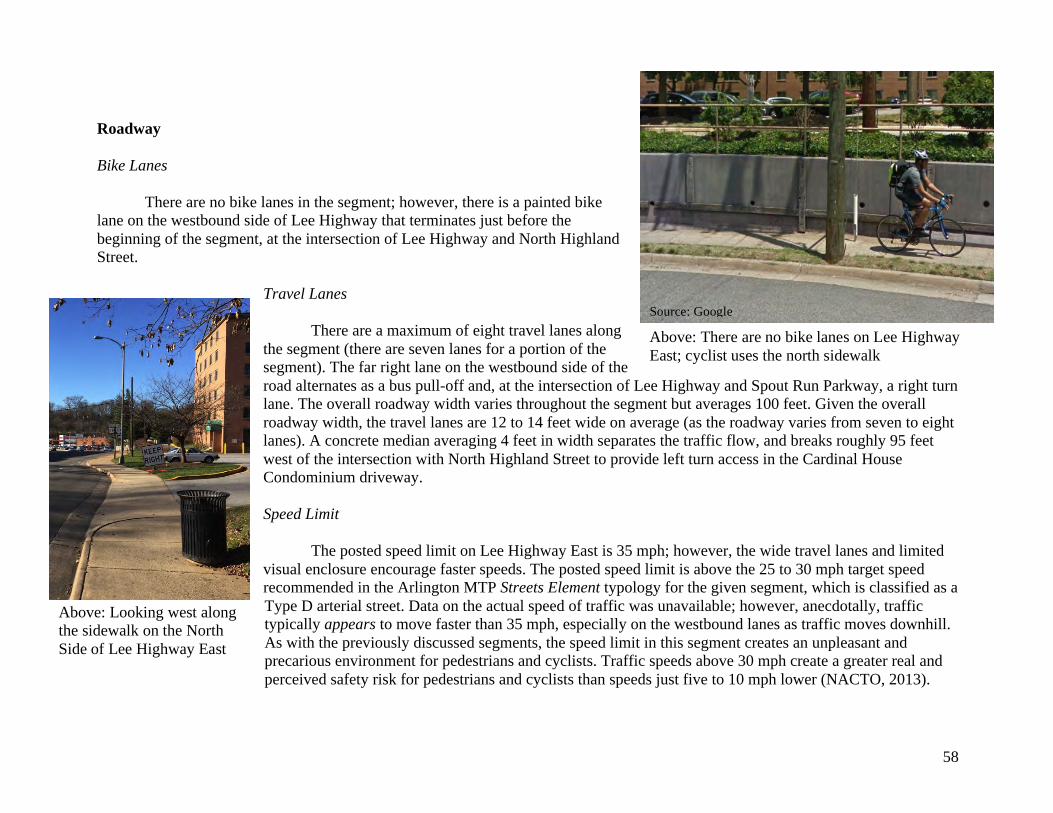
58
Roadway Bike Lanes
There are no bike lanes in the segment; however, there is a painted bike lane on the westbound side of Lee Highway that terminates just before the beginning of the segment, at the intersection of Lee Highway and North Highland Street.
Travel Lanes
There are a maximum of eight travel lanes along the segment (there are seven lanes for a portion of the segment). The far right lane on the westbound side of the road alternates as a bus pull-off and, at the intersection of Lee Highway and Spout Run Parkway, a right turn lane. The overall roadway width varies throughout the segment but averages 100 feet. Given the overall roadway width, the travel lanes are 12 to 14 feet wide on average (as the roadway varies from seven to eight lanes). A concrete median averaging 4 feet in width separates the traffic flow, and breaks roughly 95 feet west of the intersection with North Highland Street to provide left turn access in the Cardinal House Condominium driveway. Speed Limit The posted speed limit on Lee Highway East is 35 mph; however, the wide travel lanes and limited visual enclosure encourage faster speeds. The posted speed limit is above the 25 to 30 mph target speed recommended in the Arlington MTP Streets Element typology for the given segment, which is classified as a Type D arterial street. Data on the actual speed of traffic was unavailable; however, anecdotally, traffic typically appears to move faster than 35 mph, especially on the westbound lanes as traffic moves downhill. As with the previously discussed segments, the speed limit in this segment creates an unpleasant and precarious environment for pedestrians and cyclists. Traffic speeds above 30 mph create a greater real and perceived safety risk for pedestrians and cyclists than speeds just five to 10 mph lower (NACTO, 2013).
Above: There are no bike lanes on Lee Highway East; cyclist uses the north sidewalk
Above: Looking west along the sidewalk on the North Side of Lee Highway East
Source: Google
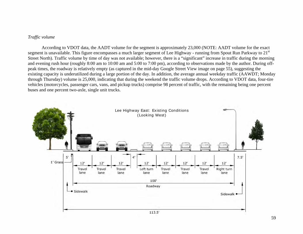
59
Traffic volume
According to VDOT data, the AADT volume for the segment is approximately 23,000 (NOTE: AADT volume for the exact segment is unavailable. This figure encompasses a much larger segment of Lee Highway - running from Spout Run Parkway to 21st Street North). Traffic volume by time of day was not available; however, there is a “significant” increase in traffic during the morning and evening rush hour (roughly 8:00 am to 10:00 am and 5:00 to 7:00 pm), according to observations made by the author. During off-peak times, the roadway is relatively empty (as captured in the mid-day Google Street View image on page 55), suggesting the existing capacity is underutilized during a large portion of the day. In addition, the average annual weekday traffic (AAWDT; Monday through Thursday) volume is 25,000, indicating that during the weekend the traffic volume drops. According to VDOT data, four-tire vehicles (motorcycles, passenger cars, vans, and pickup trucks) comprise 98 percent of traffic, with the remaining being one percent buses and one percent two-axle, single unit trucks.
Lee Highway East: Existing Conditions (Looking West)
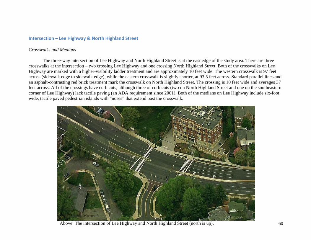
60
Intersection–LeeHighway&NorthHighlandStreet Crosswalks and Medians
The three-way intersection of Lee Highway and North Highland Street is at the east edge of the study area. There are three crosswalks at the intersection – two crossing Lee Highway and one crossing North Highland Street. Both of the crosswalks on Lee Highway are marked with a higher-visibility ladder treatment and are approximately 10 feet wide. The western crosswalk is 97 feet across (sidewalk edge to sidewalk edge), while the eastern crosswalk is slightly shorter, at 93.5 feet across. Standard parallel lines and an asphalt-contrasting red brick treatment mark the crosswalk on North Highland Street. The crossing is 10 feet wide and averages 37 feet across. All of the crossings have curb cuts, although three of curb cuts (two on North Highland Street and one on the southeastern corner of Lee Highway) lack tactile paving (an ADA requirement since 2001). Both of the medians on Lee Highway include six-foot wide, tactile paved pedestrian islands with “noses” that extend past the crosswalk.
Source: Microsoft
Above: The intersection of Lee Highway and North Highland Street (north is up).
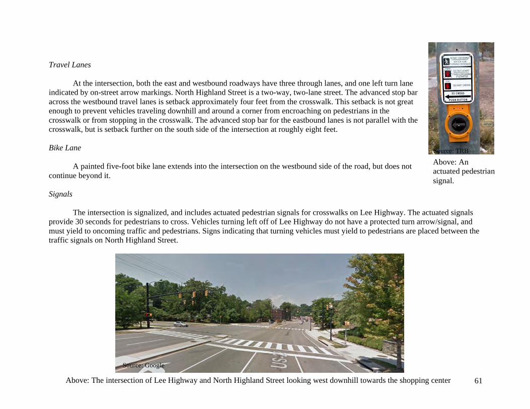
61
Travel Lanes
At the intersection, both the east and westbound roadways have three through lanes, and one left turn lane indicated by on-street arrow markings. North Highland Street is a two-way, two-lane street. The advanced stop bar across the westbound travel lanes is setback approximately four feet from the crosswalk. This setback is not great enough to prevent vehicles traveling downhill and around a corner from encroaching on pedestrians in the crosswalk or from stopping in the crosswalk. The advanced stop bar for the eastbound lanes is not parallel with the crosswalk, but is setback further on the south side of the intersection at roughly eight feet. Bike Lane
A painted five-foot bike lane extends into the intersection on the westbound side of the road, but does not continue beyond it. Signals The intersection is signalized, and includes actuated pedestrian signals for crosswalks on Lee Highway. The actuated signals provide 30 seconds for pedestrians to cross. Vehicles turning left off of Lee Highway do not have a protected turn arrow/signal, and must yield to oncoming traffic and pedestrians. Signs indicating that turning vehicles must yield to pedestrians are placed between the traffic signals on North Highland Street.
Source: TRB
Above: The intersection of Lee Highway and North Highland Street looking west downhill towards the shopping center
Above: An actuated pedestrian signal.
Source: Google
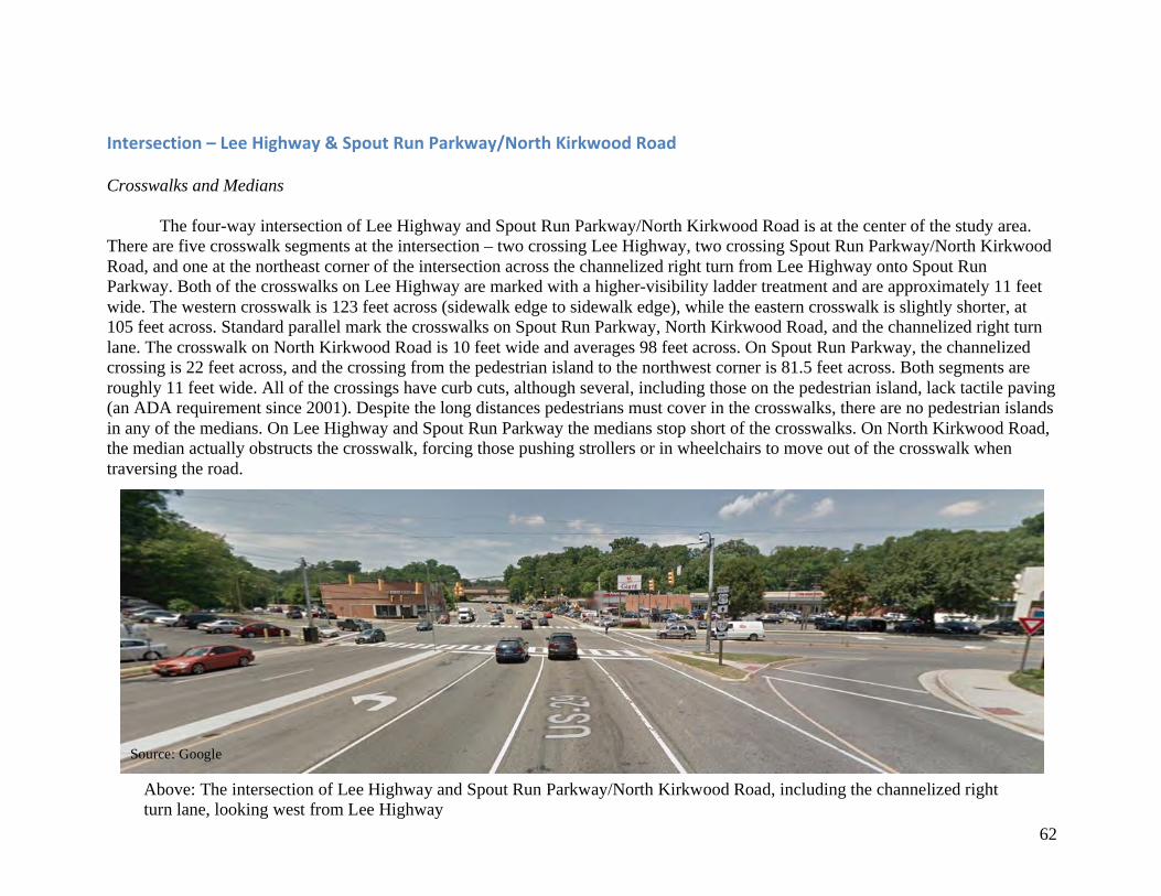
62
Intersection–LeeHighway&SpoutRunParkway/NorthKirkwoodRoad Crosswalks and Medians The four-way intersection of Lee Highway and Spout Run Parkway/North Kirkwood Road is at the center of the study area. There are five crosswalk segments at the intersection – two crossing Lee Highway, two crossing Spout Run Parkway/North Kirkwood Road, and one at the northeast corner of the intersection across the channelized right turn from Lee Highway onto Spout Run Parkway. Both of the crosswalks on Lee Highway are marked with a higher-visibility ladder treatment and are approximately 11 feet wide. The western crosswalk is 123 feet across (sidewalk edge to sidewalk edge), while the eastern crosswalk is slightly shorter, at 105 feet across. Standard parallel mark the crosswalks on Spout Run Parkway, North Kirkwood Road, and the channelized right turn lane. The crosswalk on North Kirkwood Road is 10 feet wide and averages 98 feet across. On Spout Run Parkway, the channelized crossing is 22 feet across, and the crossing from the pedestrian island to the northwest corner is 81.5 feet across. Both segments are roughly 11 feet wide. All of the crossings have curb cuts, although several, including those on the pedestrian island, lack tactile paving (an ADA requirement since 2001). Despite the long distances pedestrians must cover in the crosswalks, there are no pedestrian islands in any of the medians. On Lee Highway and Spout Run Parkway the medians stop short of the crosswalks. On North Kirkwood Road, the median actually obstructs the crosswalk, forcing those pushing strollers or in wheelchairs to move out of the crosswalk when traversing the road.
Source: Google
Above: The intersection of Lee Highway and Spout Run Parkway/North Kirkwood Road, including the channelized right turn lane, looking west from Lee Highway
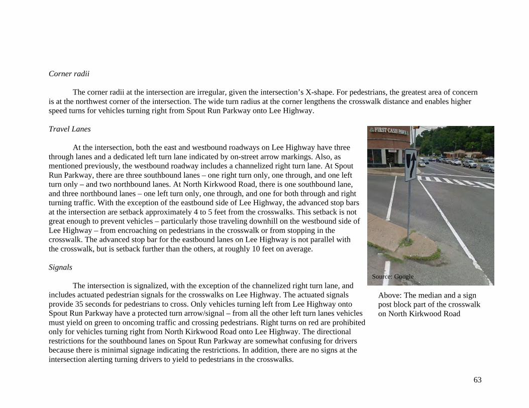
63
Corner radii
The corner radii at the intersection are irregular, given the intersection’s X-shape. For pedestrians, the greatest area of concern is at the northwest corner of the intersection. The wide turn radius at the corner lengthens the crosswalk distance and enables higher speed turns for vehicles turning right from Spout Run Parkway onto Lee Highway. Travel Lanes
At the intersection, both the east and westbound roadways on Lee Highway have three through lanes and a dedicated left turn lane indicated by on-street arrow markings. Also, as mentioned previously, the westbound roadway includes a channelized right turn lane. At Spout Run Parkway, there are three southbound lanes – one right turn only, one through, and one left turn only – and two northbound lanes. At North Kirkwood Road, there is one southbound lane, and three northbound lanes – one left turn only, one through, and one for both through and right turning traffic. With the exception of the eastbound side of Lee Highway, the advanced stop bars at the intersection are setback approximately 4 to 5 feet from the crosswalks. This setback is not great enough to prevent vehicles – particularly those traveling downhill on the westbound side of Lee Highway – from encroaching on pedestrians in the crosswalk or from stopping in the crosswalk. The advanced stop bar for the eastbound lanes on Lee Highway is not parallel with the crosswalk, but is setback further than the others, at roughly 10 feet on average. Signals The intersection is signalized, with the exception of the channelized right turn lane, and includes actuated pedestrian signals for the crosswalks on Lee Highway. The actuated signals provide 35 seconds for pedestrians to cross. Only vehicles turning left from Lee Highway onto Spout Run Parkway have a protected turn arrow/signal – from all the other left turn lanes vehicles must yield on green to oncoming traffic and crossing pedestrians. Right turns on red are prohibited only for vehicles turning right from North Kirkwood Road onto Lee Highway. The directional restrictions for the southbound lanes on Spout Run Parkway are somewhat confusing for drivers because there is minimal signage indicating the restrictions. In addition, there are no signs at the intersection alerting turning drivers to yield to pedestrians in the crosswalks.
Source: Google
Above: The median and a sign post block part of the crosswalk on North Kirkwood Road
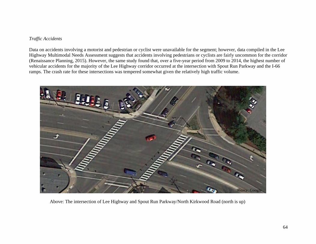
64
Traffic Accidents Data on accidents involving a motorist and pedestrian or cyclist were unavailable for the segment; however, data compiled in the Lee Highway Multimodal Needs Assessment suggests that accidents involving pedestrians or cyclists are fairly uncommon for the corridor (Renaissance Planning, 2015). However, the same study found that, over a five-year period from 2009 to 2014, the highest number of vehicular accidents for the majority of the Lee Highway corridor occurred at the intersection with Spout Run Parkway and the I-66 ramps. The crash rate for these intersections was tempered somewhat given the relatively high traffic volume.
Source: Google
Above: The intersection of Lee Highway and Spout Run Parkway/North Kirkwood Road (north is up)
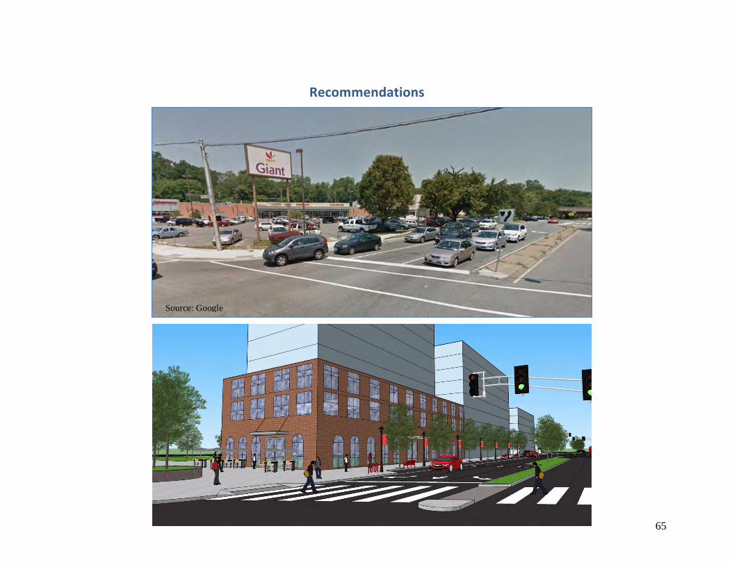
65
Recommendations
Source: Google
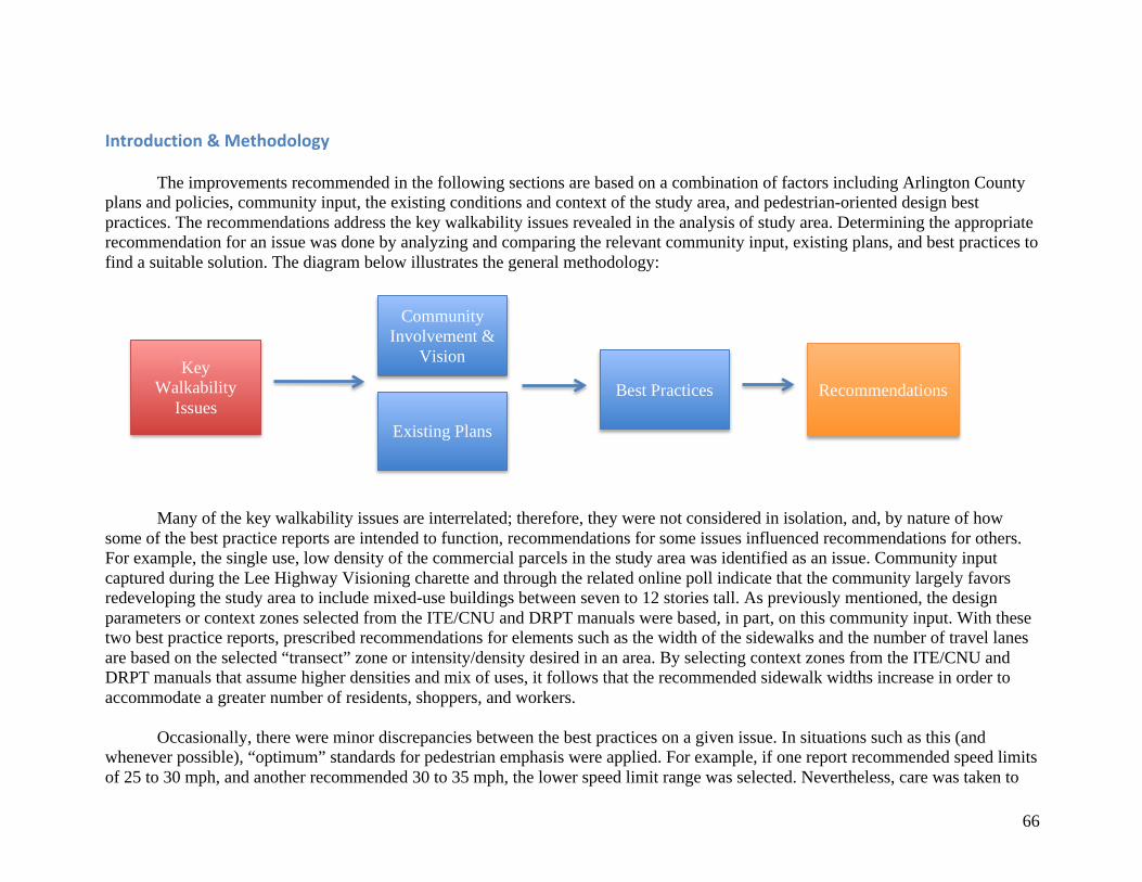
66
Introduction&Methodology
The improvements recommended in the following sections are based on a combination of factors including Arlington County plans and policies, community input, the existing conditions and context of the study area, and pedestrian-oriented design best practices. The recommendations address the key walkability issues revealed in the analysis of study area. Determining the appropriate recommendation for an issue was done by analyzing and comparing the relevant community input, existing plans, and best practices to find a suitable solution. The diagram below illustrates the general methodology:
Many of the key walkability issues are interrelated; therefore, they were not considered in isolation, and, by nature of how some of the best practice reports are intended to function, recommendations for some issues influenced recommendations for others. For example, the single use, low density of the commercial parcels in the study area was identified as an issue. Community input captured during the Lee Highway Visioning charette and through the related online poll indicate that the community largely favors redeveloping the study area to include mixed-use buildings between seven to 12 stories tall. As previously mentioned, the design parameters or context zones selected from the ITE/CNU and DRPT manuals were based, in part, on this community input. With these two best practice reports, prescribed recommendations for elements such as the width of the sidewalks and the number of travel lanes are based on the selected “transect” zone or intensity/density desired in an area. By selecting context zones from the ITE/CNU and DRPT manuals that assume higher densities and mix of uses, it follows that the recommended sidewalk widths increase in order to accommodate a greater number of residents, shoppers, and workers.
Occasionally, there were minor discrepancies between the best practices on a given issue. In situations such as this (and whenever possible), “optimum” standards for pedestrian emphasis were applied. For example, if one report recommended speed limits of 25 to 30 mph, and another recommended 30 to 35 mph, the lower speed limit range was selected. Nevertheless, care was taken to
Existing Plans
Community Involvement &
Vision
Best Practices Key
Walkability Issues
Recommendations
67
limit the overall expansion of the right-of-ways; therefore, for example, the most liberal recommendations for sidewalk width were not always selected.
Limitations
While these recommendations provide a vision and overview of how the study area might be redeveloped to create a walkable and vibrant multimodal center, some of the recommendations will require further analysis and feasibility testing that is beyond the scope of this study. For instance, reducing the number of travel lanes on Lee Highway will most likely impact traffic flow at certain times of day. The extent of the impact, and how the impact could be best mitigated are not covered in this study, but should be addressed through subsequent network and traffic scenario analysis. It is feasible that the impact could be offset through signal phasing and timing adjustments. Likewise, the exact dimensions of corner radii, gutters, and shy distances require greater engineering study. In addition, this study is relatively limited in geographic scope. Additional studies should be completed to examine how areas surrounding the Lyon Village Shopping Center could be improved in coordination. For example, this study does not address how the I-66 overpasses act as barriers between neighborhoods, nor does it discuss how the adjoining Thrifton Hill Park could be better integrated or restored. Finally, this study and the following recommendations assume that walkability is a priority design criteria and highly desired by the community. There is overwhelming evidence to support the community’s desire for better Complete Streets and walkability along Lee Highway; however, in a constricted environment, emphasis given to one mode can reduce the mobility of another. The inherent tradeoffs made in prioritizing pedestrian transport will need to be further examined and discussed by the Arlington community.
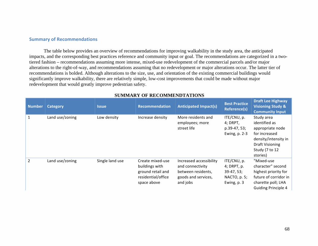
68
SummaryofRecommendations
The table below provides an overview of recommendations for improving walkability in the study area, the anticipated impacts, and the corresponding best practices reference and community input or goal. The recommendations are categorized in a two-tiered fashion – recommendations assuming more intense, mixed-use redevelopment of the commercial parcels and/or major alterations to the right-of-way, and recommendations assuming that no redevelopment or major alterations occur. The latter tier of recommendations is bolded. Although alterations to the size, use, and orientation of the existing commercial buildings would significantly improve walkability, there are relatively simple, low-cost improvements that could be made without major redevelopment that would greatly improve pedestrian safety.
SUMMARY OF RECOMMENDTATIONS
Number Category Issue Recommendation AnticipatedImpact(s) BestPracticeReference(s)
DraftLeeHighwayVisioningStudy&CommunityInput
1 Landuse/zoning Lowdensity Increasedensity Moreresidentsandemployees;morestreetlife
ITE/CNU,p.4;DRPT,p.39-47,53;Ewing,p.2-3
Studyareaidentifiedasappropriatenodeforincreaseddensity/intensityinDraftVisioningStudy(7to12stories)
2 Landuse/zoning Singlelanduse Createmixed-usebuildingswithgroundretailandresidential/officespaceabove
Increasedaccessibilityandconnectivitybetweenresidents,goodsandservices,andjobs
ITE/CNU,p.4;DRPT,p.39-47,53;NACTO,p.5;Ewing,p.3
"Mixed-usecharacter"secondhighestpriorityforfutureofcorridorincharettepoll;LHAGuidingPrinciple4
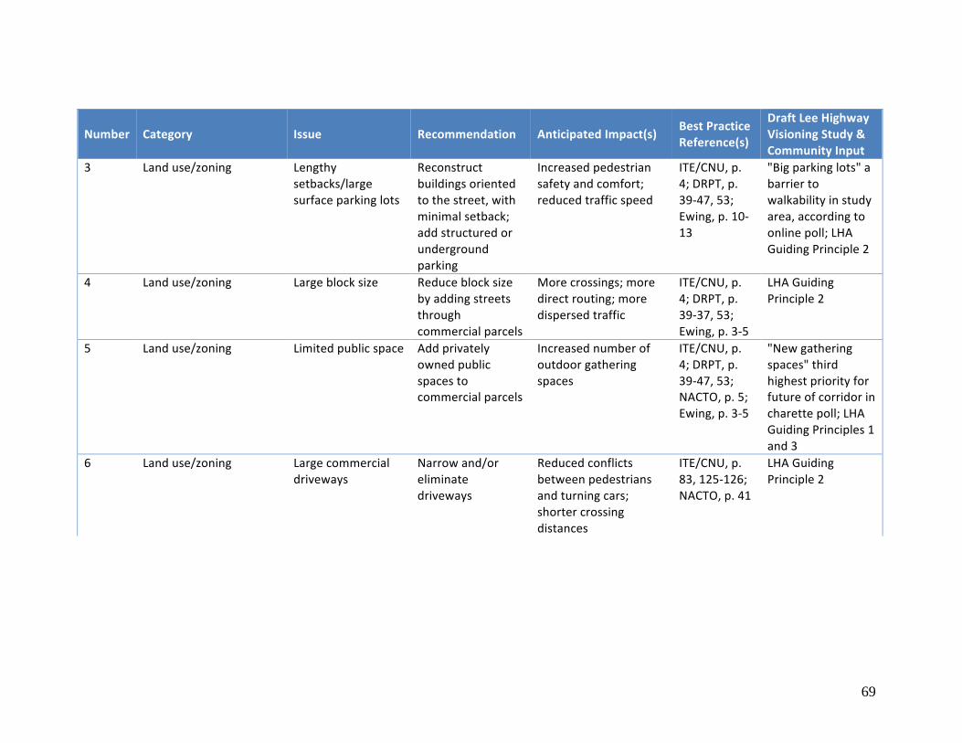
69
Number Category Issue Recommendation AnticipatedImpact(s) BestPracticeReference(s)
DraftLeeHighwayVisioningStudy&CommunityInput
3 Landuse/zoning Lengthysetbacks/largesurfaceparkinglots
Reconstructbuildingsorientedtothestreet,withminimalsetback;addstructuredorundergroundparking
Increasedpedestriansafetyandcomfort;reducedtrafficspeed
ITE/CNU,p.4;DRPT,p.39-47,53;Ewing,p.10-13
"Bigparkinglots"abarriertowalkabilityinstudyarea,accordingtoonlinepoll;LHAGuidingPrinciple2
4 Landuse/zoning Largeblocksize Reduceblocksizebyaddingstreetsthroughcommercialparcels
Morecrossings;moredirectrouting;moredispersedtraffic
ITE/CNU,p.4;DRPT,p.39-37,53;Ewing,p.3-5
LHAGuidingPrinciple2
5 Landuse/zoning Limitedpublicspace Addprivatelyownedpublicspacestocommercialparcels
Increasednumberofoutdoorgatheringspaces
ITE/CNU,p.4;DRPT,p.39-47,53;NACTO,p.5;Ewing,p.3-5
"Newgatheringspaces"thirdhighestpriorityforfutureofcorridorincharettepoll;LHAGuidingPrinciples1and3
6 Landuse/zoning Largecommercialdriveways
Narrowand/oreliminatedriveways
Reducedconflictsbetweenpedestriansandturningcars;shortercrossingdistances
ITE/CNU,p.83,125-126;NACTO,p.41
LHAGuidingPrinciple2
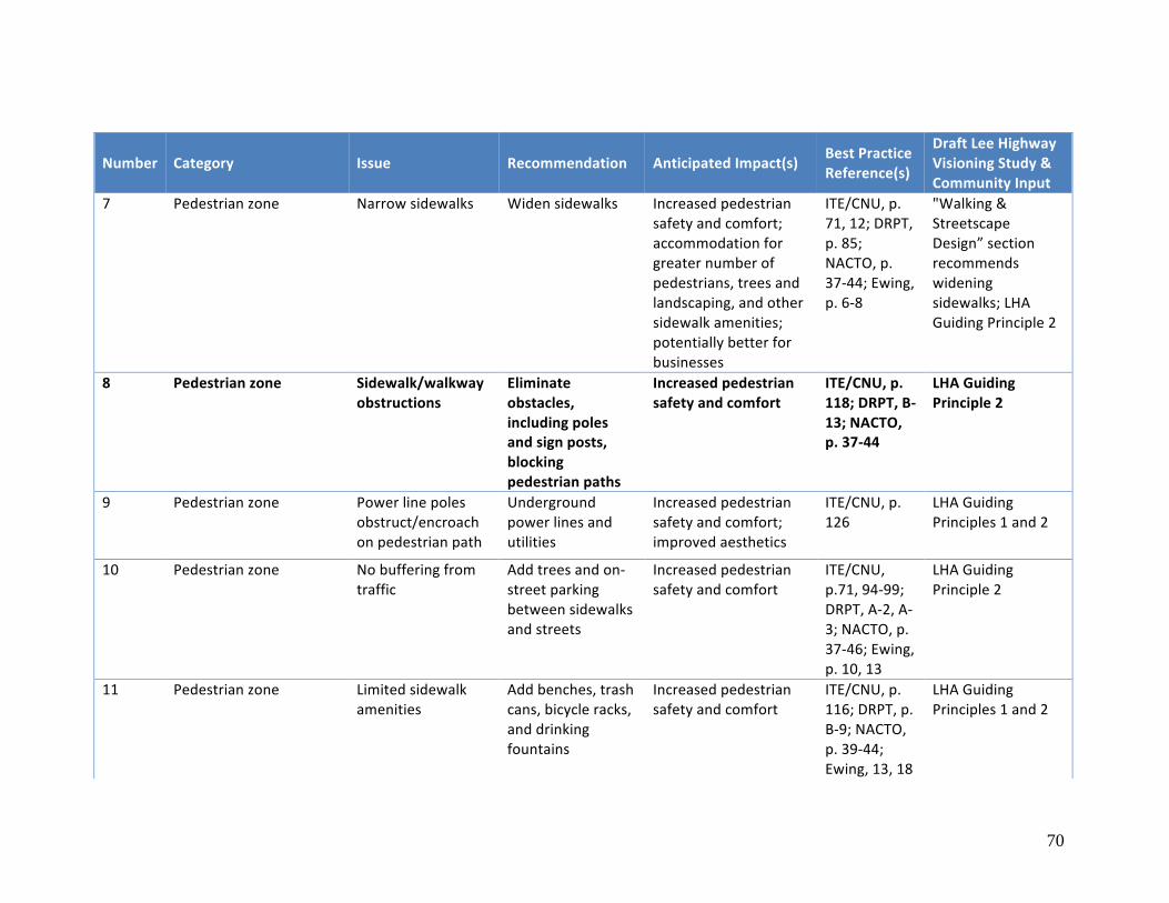
70
Number Category Issue Recommendation AnticipatedImpact(s) BestPracticeReference(s)
DraftLeeHighwayVisioningStudy&CommunityInput
7 Pedestrianzone Narrowsidewalks Widensidewalks Increasedpedestriansafetyandcomfort;accommodationforgreaternumberofpedestrians,treesandlandscaping,andothersidewalkamenities;potentiallybetterforbusinesses
ITE/CNU,p.71,12;DRPT,p.85;NACTO,p.37-44;Ewing,p.6-8
"Walking&StreetscapeDesign”sectionrecommendswideningsidewalks;LHAGuidingPrinciple2
8 Pedestrianzone Sidewalk/walkwayobstructions
Eliminateobstacles,includingpolesandsignposts,blockingpedestrianpaths
Increasedpedestriansafetyandcomfort
ITE/CNU,p.118;DRPT,B-13;NACTO,p.37-44
LHAGuidingPrinciple2
9 Pedestrianzone Powerlinepolesobstruct/encroachonpedestrianpath
Undergroundpowerlinesandutilities
Increasedpedestriansafetyandcomfort;improvedaesthetics
ITE/CNU,p.126
LHAGuidingPrinciples1and2
10 Pedestrianzone Nobufferingfromtraffic
Addtreesandon-streetparkingbetweensidewalksandstreets
Increasedpedestriansafetyandcomfort
ITE/CNU,p.71,94-99;DRPT,A-2,A-3;NACTO,p.37-46;Ewing,p.10,13
LHAGuidingPrinciple2
11 Pedestrianzone Limitedsidewalkamenities
Addbenches,trashcans,bicycleracks,anddrinkingfountains
Increasedpedestriansafetyandcomfort
ITE/CNU,p.116;DRPT,p.B-9;NACTO,p.39-44;Ewing,13,18
LHAGuidingPrinciples1and2
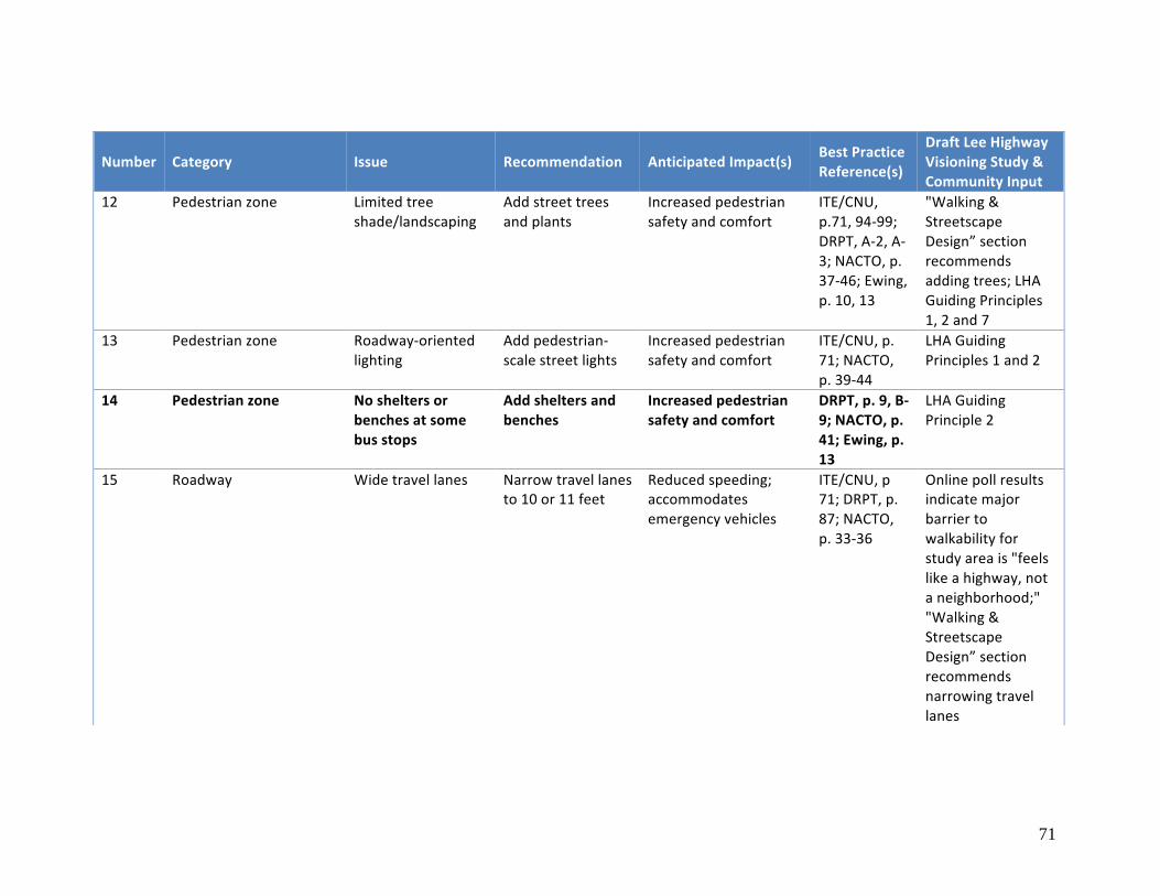
71
Number Category Issue Recommendation AnticipatedImpact(s) BestPracticeReference(s)
DraftLeeHighwayVisioningStudy&CommunityInput
12 Pedestrianzone Limitedtreeshade/landscaping
Addstreettreesandplants
Increasedpedestriansafetyandcomfort
ITE/CNU,p.71,94-99;DRPT,A-2,A-3;NACTO,p.37-46;Ewing,p.10,13
"Walking&StreetscapeDesign”sectionrecommendsaddingtrees;LHAGuidingPrinciples1,2and7
13 Pedestrianzone Roadway-orientedlighting
Addpedestrian-scalestreetlights
Increasedpedestriansafetyandcomfort
ITE/CNU,p.71;NACTO,p.39-44
LHAGuidingPrinciples1and2
14 Pedestrianzone Nosheltersorbenchesatsomebusstops
Addsheltersandbenches
Increasedpedestriansafetyandcomfort
DRPT,p.9,B-9;NACTO,p.41;Ewing,p.13
LHAGuidingPrinciple2
15 Roadway Widetravellanes Narrowtravellanesto10or11feet
Reducedspeeding;accommodatesemergencyvehicles
ITE/CNU,p71;DRPT,p.87;NACTO,p.33-36
Onlinepollresultsindicatemajorbarriertowalkabilityforstudyareais"feelslikeahighway,notaneighborhood;""Walking&StreetscapeDesign”sectionrecommendsnarrowingtravellanes
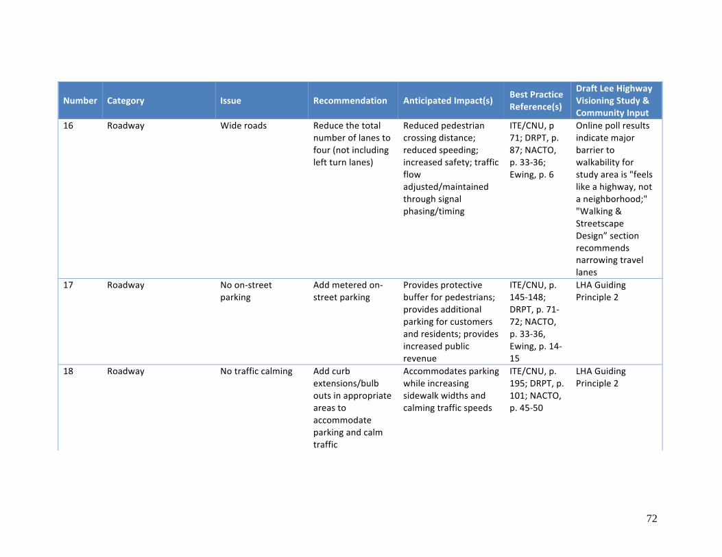
72
Number Category Issue Recommendation AnticipatedImpact(s) BestPracticeReference(s)
DraftLeeHighwayVisioningStudy&CommunityInput
16 Roadway Wideroads Reducethetotalnumberoflanestofour(notincludingleftturnlanes)
Reducedpedestriancrossingdistance;reducedspeeding;increasedsafety;trafficflowadjusted/maintainedthroughsignalphasing/timing
ITE/CNU,p71;DRPT,p.87;NACTO,p.33-36;Ewing,p.6
Onlinepollresultsindicatemajorbarriertowalkabilityforstudyareais"feelslikeahighway,notaneighborhood;""Walking&StreetscapeDesign”sectionrecommendsnarrowingtravellanes
17 Roadway Noon-streetparking
Addmeteredon-streetparking
Providesprotectivebufferforpedestrians;providesadditionalparkingforcustomersandresidents;providesincreasedpublicrevenue
ITE/CNU,p.145-148;DRPT,p.71-72;NACTO,p.33-36,Ewing,p.14-15
LHAGuidingPrinciple2
18 Roadway Notrafficcalming Addcurbextensions/bulboutsinappropriateareastoaccommodateparkingandcalmtraffic
Accommodatesparkingwhileincreasingsidewalkwidthsandcalmingtrafficspeeds
ITE/CNU,p.195;DRPT,p.101;NACTO,p.45-50
LHAGuidingPrinciple2

73
Number Category Issue Recommendation AnticipatedImpact(s) BestPracticeReference(s)
DraftLeeHighwayVisioningStudy&CommunityInput
19 Roadway Speedlimittoohigh(35mph)
Reducespeedlimitto25mph,30mphmaximum
Improvedsafetyforpedestriansanddrivers;reducesseverityofaccidents
ITE/CNU,p.71;DRPT,39-47;NACTO,p.139-141
Onlinepollresultsindicatemajorbarriertowalkabilityforstudyareais"feelslikeahighway,notaneighborhood;""Walking&StreetscapeDesign”sectionrecommendsslowingtrafficspeeds,generally
20 Roadway Widecurbs Narrowcurbradiitopreventdangerous,highspeedturns
Increasedpedestriansafetyandcomfort
ITE/CNU,p.184-187;NACTO,p.117-120;Ewing,p.8-9
LHAGuidingPrinciple2
21 Roadway Nobicyclelanesormarkings
Addbicyclelanesorsharrowmarkings
Increasedcyclistsafetyandcomfort
ITE/CNU,p.143-145;DRPT,p.86-87;NACTO,p.33-36
LHAGuidingPrinciple2
22 Intersections/crosswalks Low-visibilitycrosswalkmarkings
Addhighervisibility"zebrastripe"markingsatallcrosswalks
Increasedpedestriansafetyandcomfort
ITE/CNU,p.193-195;DRPT,p.98;NACTO,p.113
LHAGuidingPrinciple2
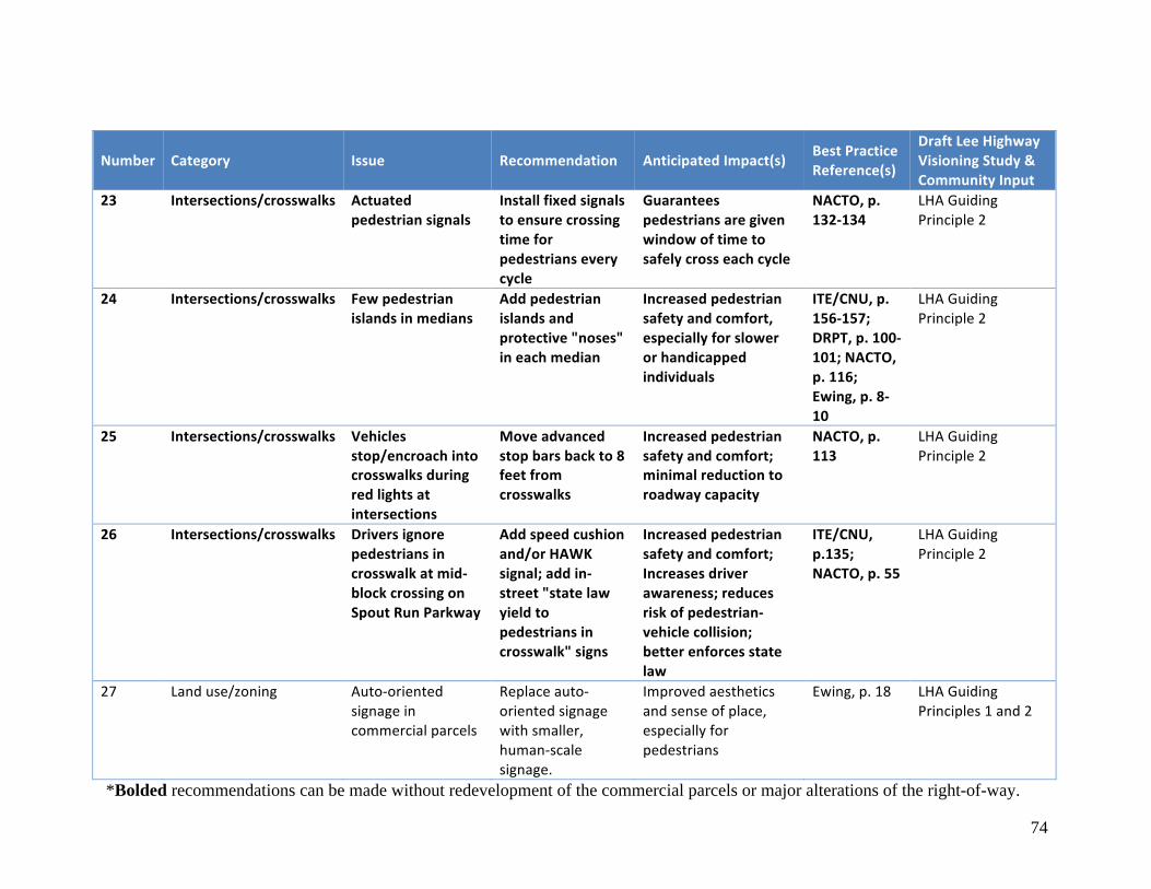
74
Number Category Issue Recommendation AnticipatedImpact(s) BestPracticeReference(s)
DraftLeeHighwayVisioningStudy&CommunityInput
23 Intersections/crosswalks Actuatedpedestriansignals
Installfixedsignalstoensurecrossingtimeforpedestrianseverycycle
Guaranteespedestriansaregivenwindowoftimetosafelycrosseachcycle
NACTO,p.132-134
LHAGuidingPrinciple2
24 Intersections/crosswalks Fewpedestrianislandsinmedians
Addpedestrianislandsandprotective"noses"ineachmedian
Increasedpedestriansafetyandcomfort,especiallyforslowerorhandicappedindividuals
ITE/CNU,p.156-157;DRPT,p.100-101;NACTO,p.116;Ewing,p.8-10
LHAGuidingPrinciple2
25 Intersections/crosswalks Vehiclesstop/encroachintocrosswalksduringredlightsatintersections
Moveadvancedstopbarsbackto8feetfromcrosswalks
Increasedpedestriansafetyandcomfort;minimalreductiontoroadwaycapacity
NACTO,p.113
LHAGuidingPrinciple2
26 Intersections/crosswalks Driversignorepedestriansincrosswalkatmid-blockcrossingonSpoutRunParkway
Addspeedcushionand/orHAWKsignal;addin-street"statelawyieldtopedestriansincrosswalk"signs
Increasedpedestriansafetyandcomfort;Increasesdriverawareness;reducesriskofpedestrian-vehiclecollision;betterenforcesstatelaw
ITE/CNU,p.135;NACTO,p.55
LHAGuidingPrinciple2
27 Landuse/zoning Auto-orientedsignageincommercialparcels
Replaceauto-orientedsignagewithsmaller,human-scalesignage.
Improvedaestheticsandsenseofplace,especiallyforpedestrians
Ewing,p.18 LHAGuidingPrinciples1and2
*Bolded recommendations can be made without redevelopment of the commercial parcels or major alterations of the right-of-way.
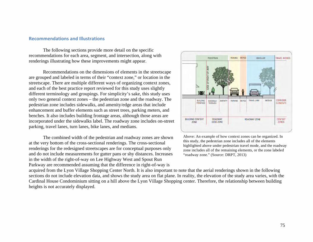
75
RecommendationsandIllustrations
The following sections provide more detail on the specific recommendations for each area, segment, and intersection, along with renderings illustrating how these improvements might appear.
Recommendations on the dimensions of elements in the streetscape are grouped and labeled in terms of their “context zone,” or location in the streetscape. There are multiple different ways of organizing context zones, and each of the best practice report reviewed for this study uses slightly different terminology and groupings. For simplicity’s sake, this study uses only two general context zones – the pedestrian zone and the roadway. The pedestrian zone includes sidewalks, and amenity/edge areas that include enhancement and buffer elements such as street trees, parking meters, and benches. It also includes building frontage areas, although those areas are incorporated under the sidewalks label. The roadway zone includes on-street parking, travel lanes, turn lanes, bike lanes, and medians.
The combined width of the pedestrian and roadway zones are shown at the very bottom of the cross-sectional renderings. The cross-sectional renderings for the redesigned streetscapes are for conceptual purposes only and do not include measurements for gutter pans or shy distances. Increases in the width of the right-of-way on Lee Highway West and Spout Run Parkway are recommended assuming that the difference in right-of-way is acquired from the Lyon Village Shopping Center North. It is also important to note that the aerial renderings shown in the following sections do not include elevation data, and shows the study area on flat plane. In reality, the elevation of the study area varies, with the Cardinal House Condominium sitting on a hill above the Lyon Village Shopping center. Therefore, the relationship between building heights is not accurately displayed.
Above: An example of how context zones can be organized. In this study, the pedestrian zone includes all of the elements highlighted above under pedestrian travel mode, and the roadway zone includes all of the remaining elements, or the zone labeled “roadway zone.” (Source: DRPT, 2013)
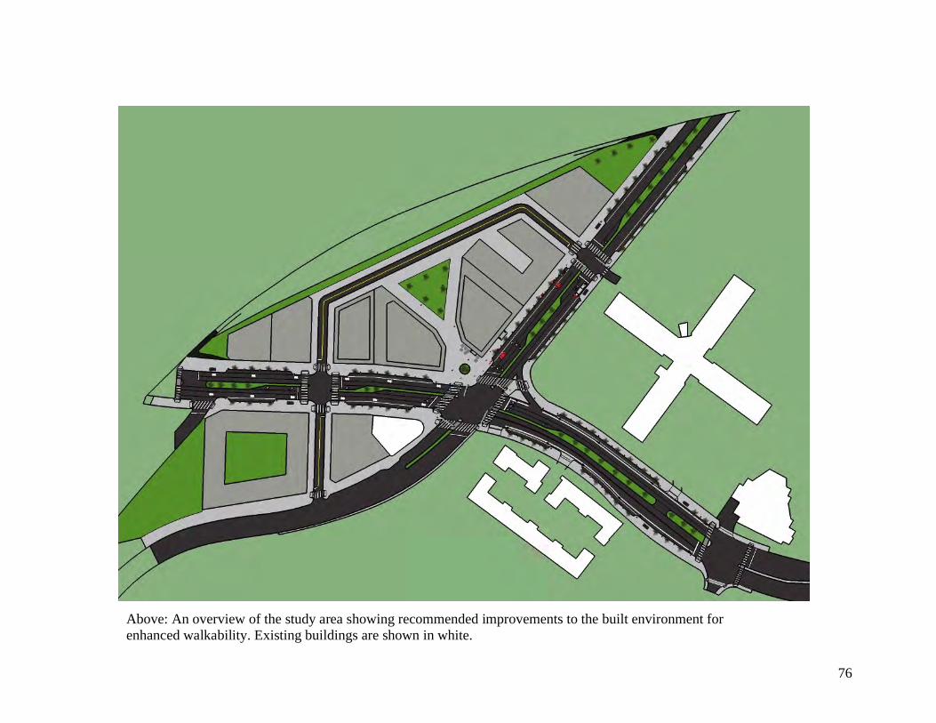
76
Above: An overview of the study area showing recommended improvements to the built environment for enhanced walkability. Existing buildings are shown in white.
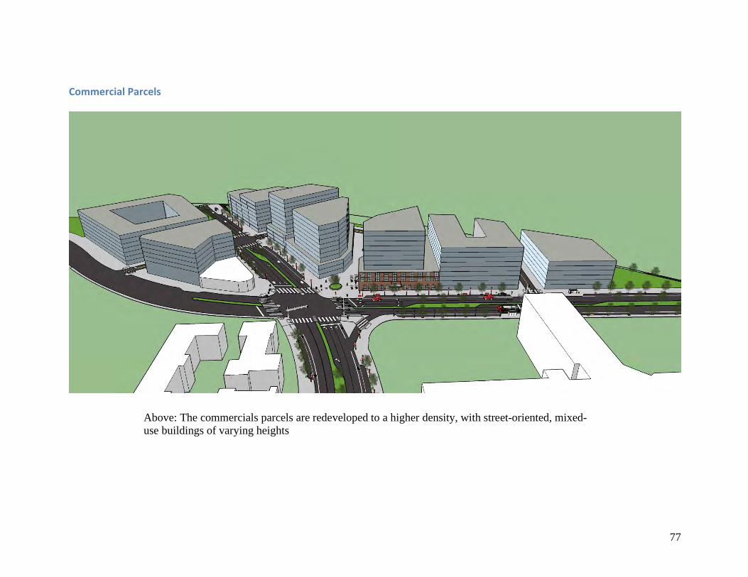
77
CommercialParcels
Above: The commercials parcels are redeveloped to a higher density, with street-oriented, mixed-
use buildings of varying heights
78
Land Use and Zoning
Mixed-use, commercial and residential redevelopment is recommended for the existing commercial parcels. The ground level should ideally contain retail businesses, restaurants, or groceries while the floors above contain residential apartments. Aggressive measures should be taken to retain the local businesses currently operating in the shopping center. Some limited office space on the floors above the ground retail may also be appropriate or desirable.
According to both the ITE/CNU and DRPT reports, and Ewing’s primer, a mix of land uses is essential to creating a walkable community and multimodal center (ITE/CNU, 2010; DRPT, 2013; Ewing). The mix of uses supports pedestrian trips and helps create a vibrant and safe atmosphere during both the day and evening time. Residents generate business for the commercial retailers and the retailers provide convenient goods and services, increasing the livability and economic vitality of the area.
Under the current zoning regulations, the commercial parcels are designated C-2 Service Commercial. In order to achieved mixed-use development, a Unified Commercial Mixed Use Development (UCMUD) use permit must be issued to the developer, since it is not permitted by-right. The County may also wish to investigate rezoning the parcels or allowing other special exceptions in order to achieve the desired mix of uses and building orientation, placement, and heights. Building Orientation
All newly developed or redeveloped buildings should be oriented to the street, with little-to-no setback, other than what is necessary to accommodate outdoor seating along the sidewalk. The buildings should abut one another, leaving little “dead space” except in cases where alleyways are necessary or public spaces are provided. All of the building entrances should be in the front facing the street, and windows should wrap the ground level. Street-oriented buildings fall under Ewing’s list of “essential” pedestrian-friendly features because they increase accessibility, safety, visual enclosure, and transparency (Ewing). The ITE/CNU guidelines also note that street facing buildings are a core characteristic of walkable communities (ITE/CNU, 2010). Building Heights
Building heights should vary depending on their location and the typography; however, heights between seven to 12 stories are appropriate based on the community input reviewed for this report (DKA, 2016).
79
Public Spaces
New public spaces should be included in the redevelopment of the commercial parcels for creating a more attractive and vibrant node, in accordance with community desires. The spaces should include shade trees, public art, and places for people to gather, sit, and relax. The spaces should be highly accessible for pedestrians approaching from different directions. As Ewing notes, nearby parks and other public spaces are attractions for pedestrians, and “people are more likely to walk when they have some place specific, and nearby, to go” (Ewing). Parking
Off-street parking for residents and retail patrons should ideally be placed underground. This may not be feasible at Lyon Village Shopping Center North, because the Spout Run tributary flows underneath the existing commercial development. In the case that underground parking cannot be accommodated, any off-street surface parking should be placed behind the mixed-use buildings or in structured parking garages, with special attention paid and/or materials used to curtail storm water runoff. Overall, parking should be kept to a minimum, since the goal is to encourage active and public transit mode trips. Surface parking lots crowd out active uses, and are often dead space for a significant portion of the day (Ewing). New Roadways
New, minor streets should be added during redevelopment to reduce the lengths of the blocks and increase accessibility for pedestrians, cyclists, and motorists. The roadways could have on-street parking or simply be wide enough to provide access for underground parking, trash removal, and emergency vehicles.
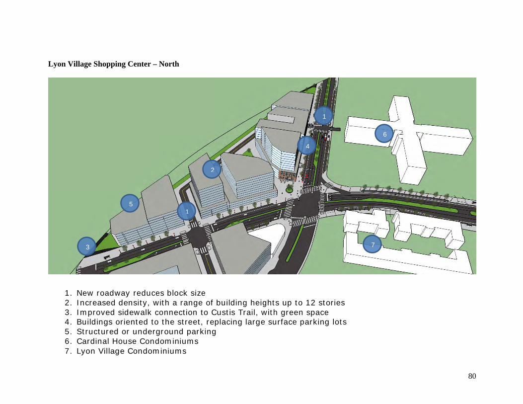
80
Lyon Village Shopping Center – North
1
2
3
4
5
6
7
1. New roadway reduces block size 2. Increased density, with a range of building heights up to 12 stories 3. Improved sidewalk connection to Custis Trail, with green space 4. Buildings oriented to the street, replacing large surface parking lots 5. Structured or underground parking 6. Cardinal House Condominiums 7. Lyon Village Condominiums
1
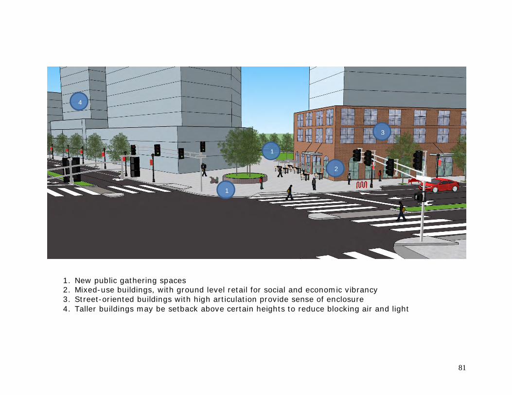
81
1
2
3
4
1
1. New public gathering spaces 2. Mixed-use buildings, with ground level retail for social and economic vibrancy 3. Street-oriented buildings with high articulation provide sense of enclosure 4. Taller buildings may be setback above certain heights to reduce blocking air and light
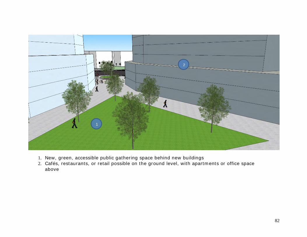
82
1
2
1. New, green, accessible public gathering space behind new buildings 2. Cafés, restaurants, or retail possible on the ground level, with apartments or office space
above
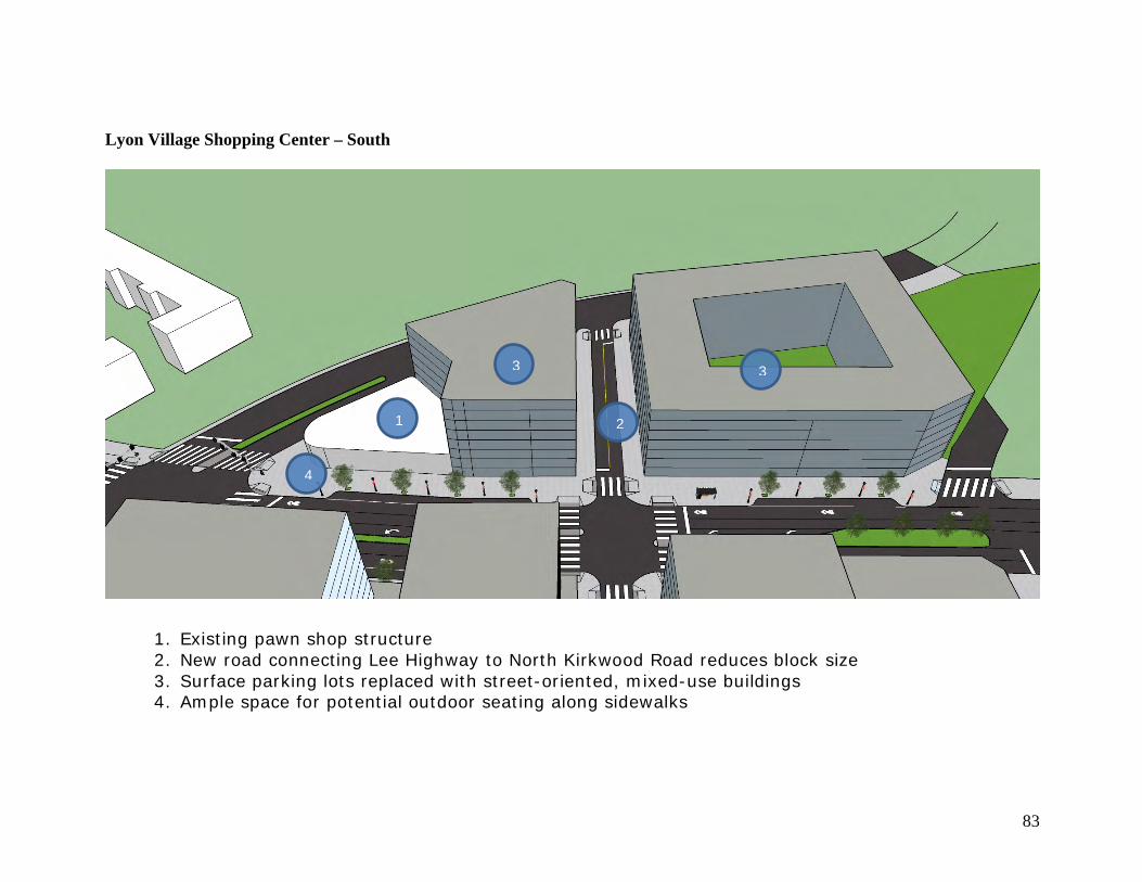
83
Lyon Village Shopping Center – South
1
2
3
4
1. Existing pawn shop structure 2. New road connecting Lee Highway to North Kirkwood Road reduces block size 3. Surface parking lots replaced with street-oriented, mixed-use buildings 4. Ample space for potential outdoor seating along sidewalks
3
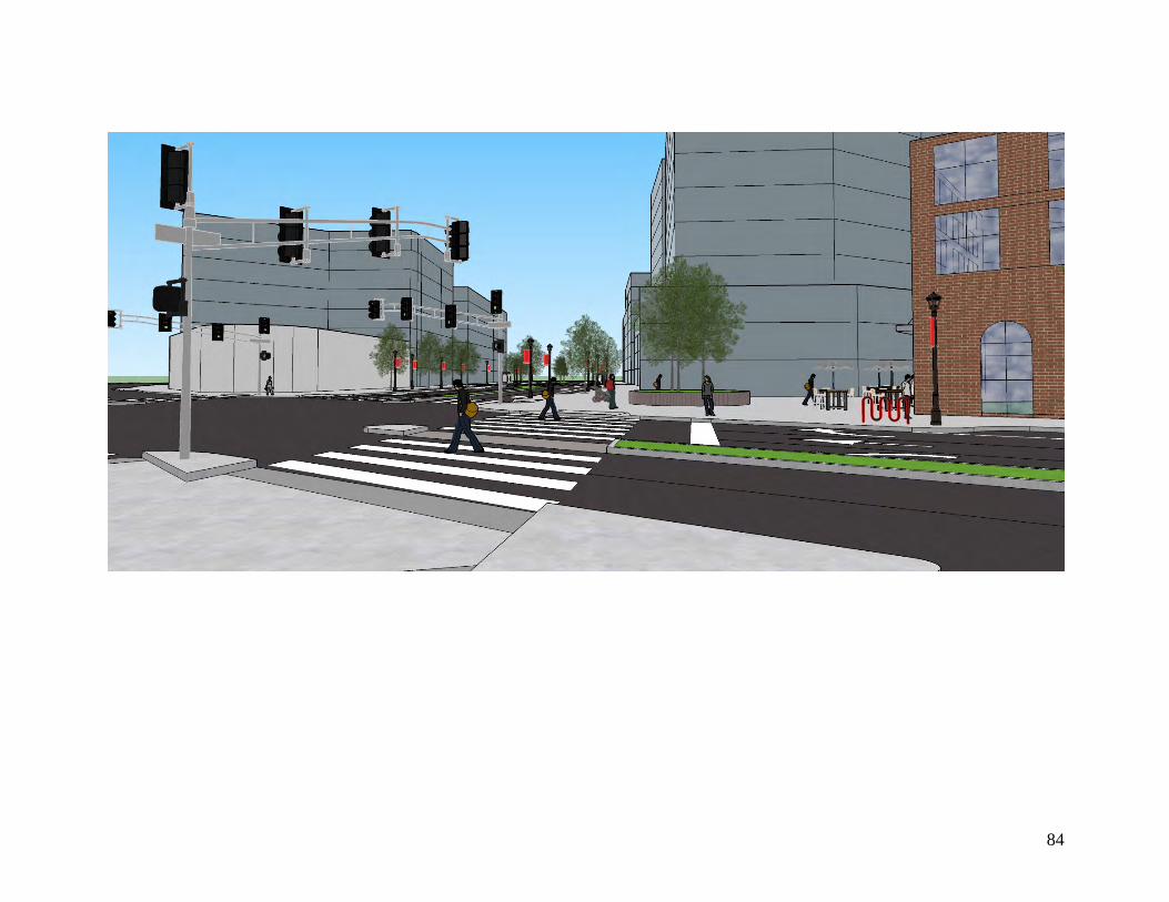
84
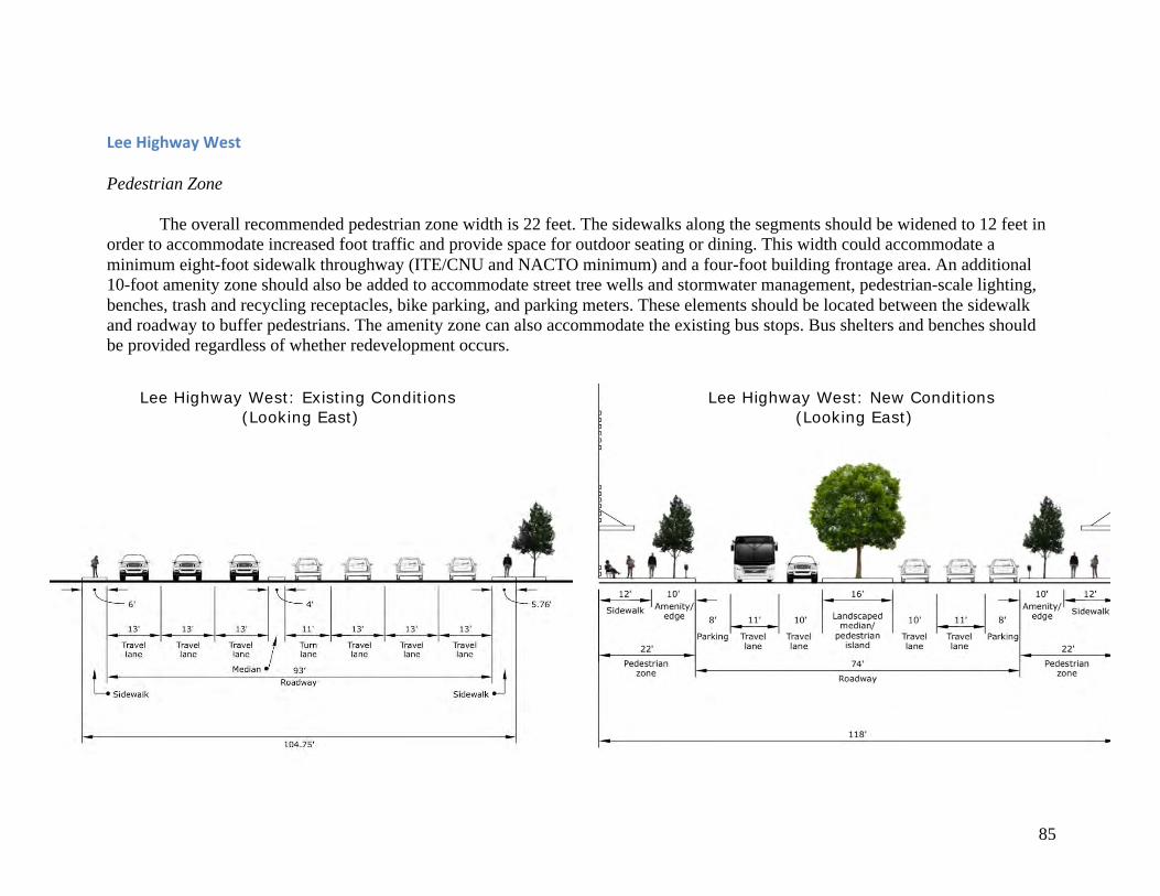
85
LeeHighwayWest Pedestrian Zone The overall recommended pedestrian zone width is 22 feet. The sidewalks along the segments should be widened to 12 feet in order to accommodate increased foot traffic and provide space for outdoor seating or dining. This width could accommodate a minimum eight-foot sidewalk throughway (ITE/CNU and NACTO minimum) and a four-foot building frontage area. An additional 10-foot amenity zone should also be added to accommodate street tree wells and stormwater management, pedestrian-scale lighting, benches, trash and recycling receptacles, bike parking, and parking meters. These elements should be located between the sidewalk and roadway to buffer pedestrians. The amenity zone can also accommodate the existing bus stops. Bus shelters and benches should be provided regardless of whether redevelopment occurs.
Lee Highway West: Existing Conditions (Looking East)
Lee Highway West: New Conditions (Looking East)

86
Roadway
The overall recommended roadway width is 74 feet, a reduction from the existing 93-foot average width (see renderings on the previous page). Eight feet of on-street parking should be added to both sides of the roadway to accommodate the retail businesses and buffer pedestrians. The overall number of travel lanes should be reduced from seven to four. An 11-foot width (wide enough to accommodate buses and emergency vehicles) is recommended for the outer travel lanes, while 10 feet is recommended for the inner travel lanes. The narrower travel lanes reduce unintended speeding (without necessarily reducing traffic flow), reduce crossing distances, and lead to shorter signal cycles and less stormwater runoff (NACTO, 2013). A 16-foot wide, tree-lined or landscaped median separates traffic flow and is wide enough to accommodate a 10-foot left turn lane and 6-foot pedestrian island in the crosswalk at the intersection of Lee Highway and Spout Run Parkway/North Kirkwood Road. In accordance with the existing Arlington County street typology, ITE/CNU guidelines, and NACTO recommendations, the posted speed limit should be reduced from 35 mph to 25 to 30 mph. This speed limit reduction is recommended regardless of redevelopment occurring. As discussed previously, marginally lower traffic speeds can greatly reduce the severity of accidents. A shared lane marking, or “sharrow,” could be added to outer travel lanes to increase driver awareness of cyclists. Intersections and Crosswalks
Assuming a new roadway is constructed through the commercial parcels during redevelopment, a new signalized four-way intersection should be added where the road intersects with Lee Highway – ideally near the center of the segment. Both the new intersection, and the existing intersection with I-66 should include fixed pedestrian signalization. Fixed signalization should be considered in replacement of the existing actuated signals, regardless of redevelopment. High-visibility zebra markings should be used at the crosswalks. Conventional curb extensions should be employed to reduce corner radii and crossing distances, while increasing driver visibility. At all intersections, the advanced stop bars should be moved back to eight feet from the crosswalks in order to better prevent vehicles from stopping in the crosswalks on red lights, especially those travelling downhill.
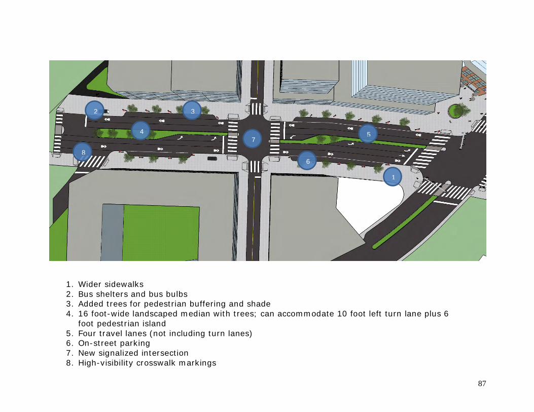
87
1
2 3
4 5
6
7
8
1. Wider sidewalks 2. Bus shelters and bus bulbs 3. Added trees for pedestrian buffering and shade 4. 16 foot-wide landscaped median with trees; can accommodate 10 foot left turn lane plus 6
foot pedestrian island 5. Four travel lanes (not including turn lanes) 6. On-street parking 7. New signalized intersection 8. High-visibility crosswalk markings
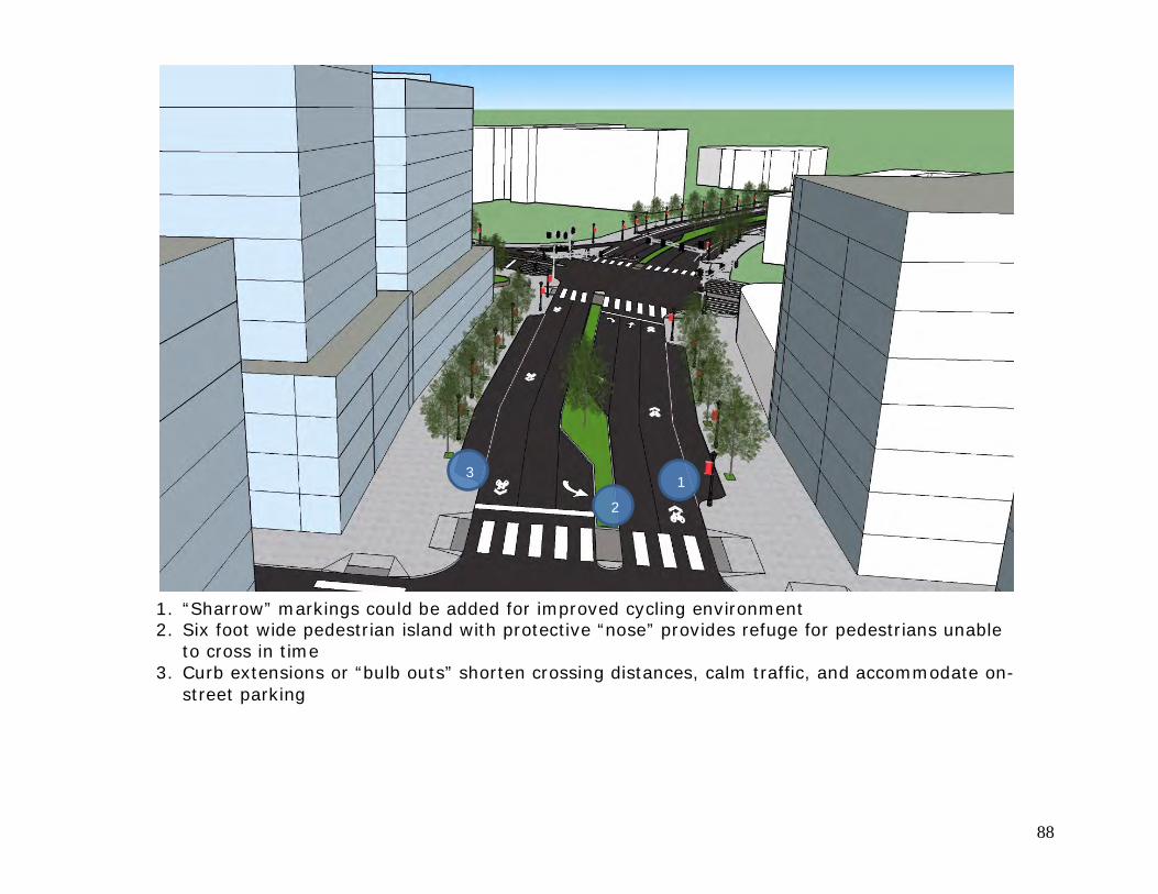
88
1. “Sharrow” markings could be added for improved cycling environment 2. Six foot wide pedestrian island with protective “nose” provides refuge for pedestrians unable
to cross in time 3. Curb extensions or “bulb outs” shorten crossing distances, calm traffic, and accommodate on-
street parking
1 2
3
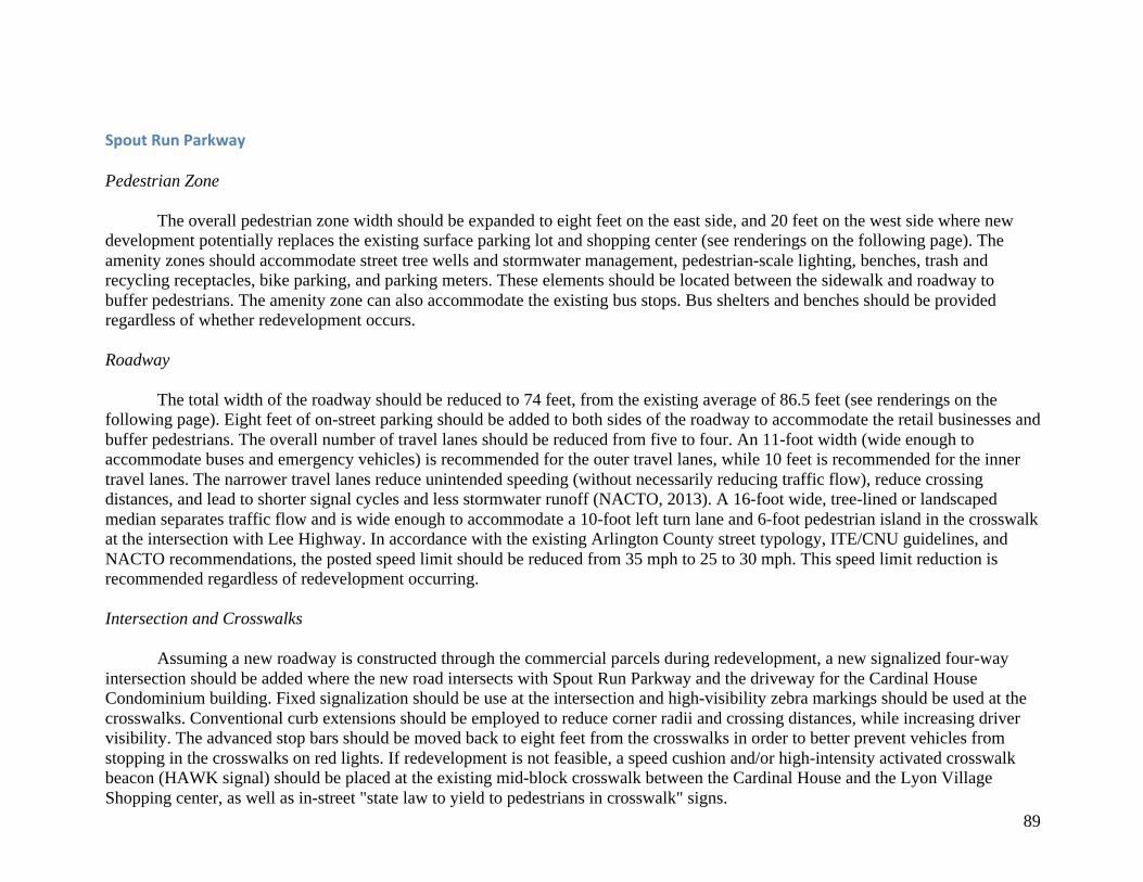
89
SpoutRunParkway Pedestrian Zone
The overall pedestrian zone width should be expanded to eight feet on the east side, and 20 feet on the west side where new development potentially replaces the existing surface parking lot and shopping center (see renderings on the following page). The amenity zones should accommodate street tree wells and stormwater management, pedestrian-scale lighting, benches, trash and recycling receptacles, bike parking, and parking meters. These elements should be located between the sidewalk and roadway to buffer pedestrians. The amenity zone can also accommodate the existing bus stops. Bus shelters and benches should be provided regardless of whether redevelopment occurs. Roadway
The total width of the roadway should be reduced to 74 feet, from the existing average of 86.5 feet (see renderings on the following page). Eight feet of on-street parking should be added to both sides of the roadway to accommodate the retail businesses and buffer pedestrians. The overall number of travel lanes should be reduced from five to four. An 11-foot width (wide enough to accommodate buses and emergency vehicles) is recommended for the outer travel lanes, while 10 feet is recommended for the inner travel lanes. The narrower travel lanes reduce unintended speeding (without necessarily reducing traffic flow), reduce crossing distances, and lead to shorter signal cycles and less stormwater runoff (NACTO, 2013). A 16-foot wide, tree-lined or landscaped median separates traffic flow and is wide enough to accommodate a 10-foot left turn lane and 6-foot pedestrian island in the crosswalk at the intersection with Lee Highway. In accordance with the existing Arlington County street typology, ITE/CNU guidelines, and NACTO recommendations, the posted speed limit should be reduced from 35 mph to 25 to 30 mph. This speed limit reduction is recommended regardless of redevelopment occurring. Intersection and Crosswalks
Assuming a new roadway is constructed through the commercial parcels during redevelopment, a new signalized four-way intersection should be added where the new road intersects with Spout Run Parkway and the driveway for the Cardinal House Condominium building. Fixed signalization should be use at the intersection and high-visibility zebra markings should be used at the crosswalks. Conventional curb extensions should be employed to reduce corner radii and crossing distances, while increasing driver visibility. The advanced stop bars should be moved back to eight feet from the crosswalks in order to better prevent vehicles from stopping in the crosswalks on red lights. If redevelopment is not feasible, a speed cushion and/or high-intensity activated crosswalk beacon (HAWK signal) should be placed at the existing mid-block crosswalk between the Cardinal House and the Lyon Village Shopping center, as well as in-street "state law to yield to pedestrians in crosswalk" signs.
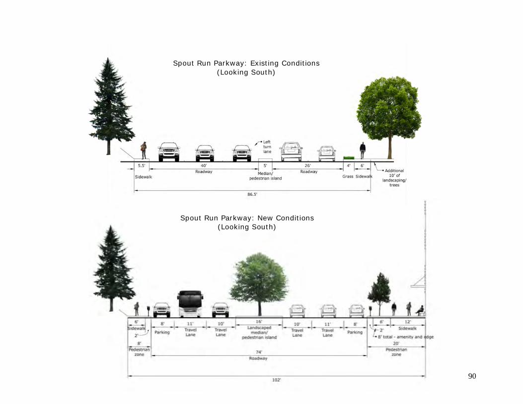
90
Spout Run Parkway: Existing Conditions (Looking South)
Spout Run Parkway: New Conditions (Looking South) (Looking South)
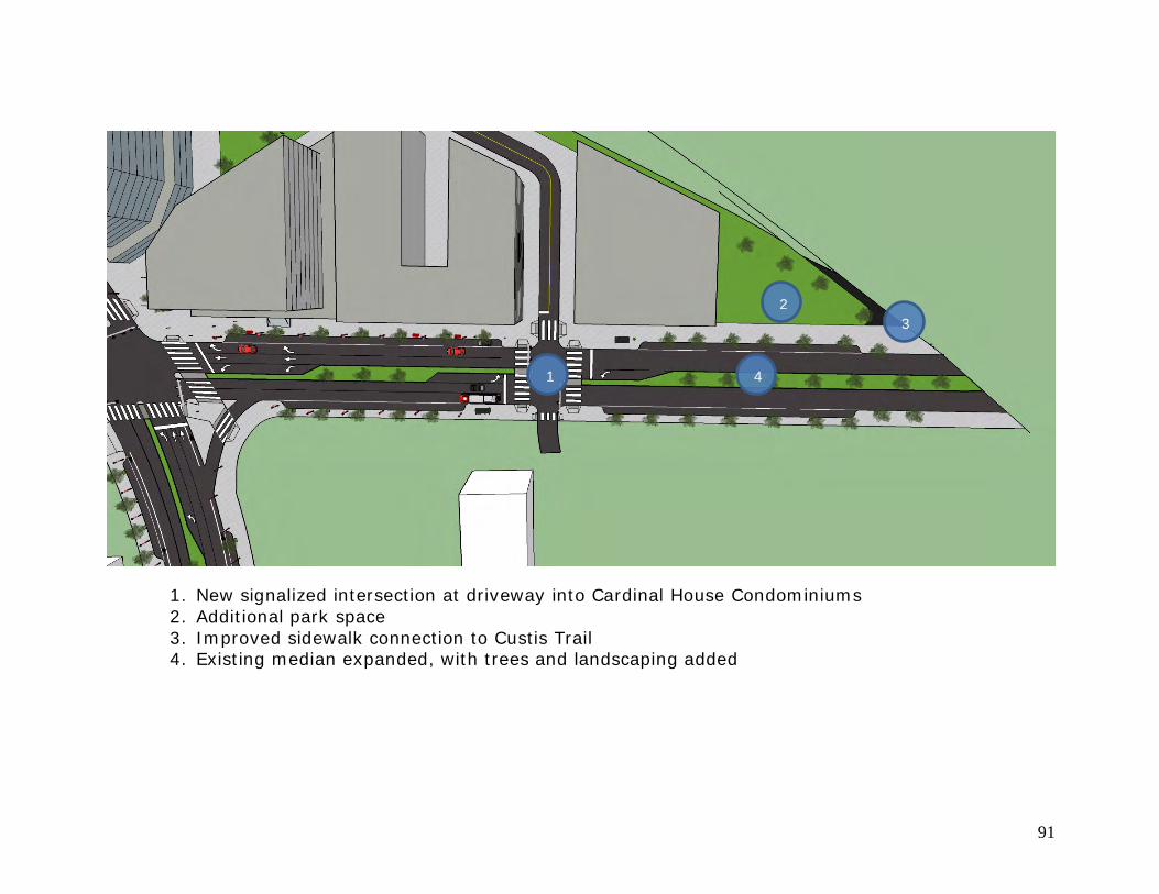
91
1
2 3
4
1. New signalized intersection at driveway into Cardinal House Condominiums 2. Additional park space 3. Improved sidewalk connection to Custis Trail 4. Existing median expanded, with trees and landscaping added
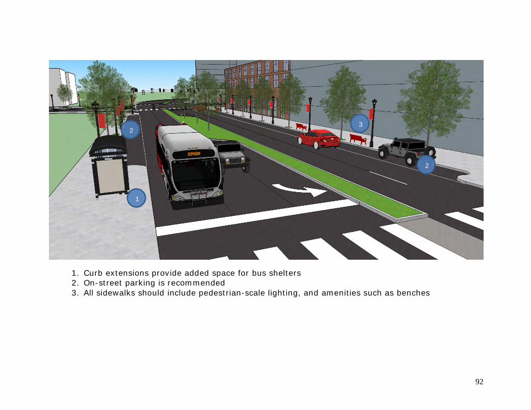
92
1
2
3 2
1. Curb extensions provide added space for bus shelters 2. On-street parking is recommended 3. All sidewalks should include pedestrian-scale lighting, and amenities such as benches
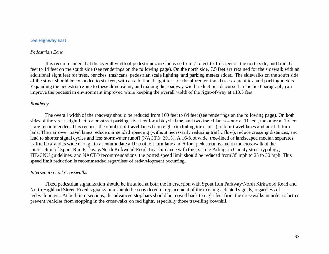
93
LeeHighwayEast Pedestrian Zone
It is recommended that the overall width of pedestrian zone increase from 7.5 feet to 15.5 feet on the north side, and from 6 feet to 14 feet on the south side (see renderings on the following page). On the north side, 7.5 feet are retained for the sidewalk with an additional eight feet for trees, benches, trashcans, pedestrian scale lighting, and parking meters added. The sidewalks on the south side of the street should be expanded to six feet, with an additional eight feet for the aforementioned trees, amenities, and parking meters. Expanding the pedestrian zone to these dimensions, and making the roadway width reductions discussed in the next paragraph, can improve the pedestrian environment improved while keeping the overall width of the right-of-way at 113.5 feet. Roadway
The overall width of the roadway should be reduced from 100 feet to 84 feet (see renderings on the following page). On both sides of the street, eight feet for on-street parking, five feet for a bicycle lane, and two travel lanes – one at 11 feet, the other at 10 feet – are recommended. This reduces the number of travel lanes from eight (including turn lanes) to four travel lanes and one left turn lane. The narrower travel lanes reduce unintended speeding (without necessarily reducing traffic flow), reduce crossing distances, and lead to shorter signal cycles and less stormwater runoff (NACTO, 2013). A 16-foot wide, tree-lined or landscaped median separates traffic flow and is wide enough to accommodate a 10-foot left turn lane and 6-foot pedestrian island in the crosswalk at the intersection of Spout Run Parkway/North Kirkwood Road. In accordance with the existing Arlington County street typology, ITE/CNU guidelines, and NACTO recommendations, the posted speed limit should be reduced from 35 mph to 25 to 30 mph. This speed limit reduction is recommended regardless of redevelopment occurring. Intersection and Crosswalks
Fixed pedestrian signalization should be installed at both the intersection with Spout Run Parkway/North Kirkwood Road and North Highland Street. Fixed signalization should be considered in replacement of the existing actuated signals, regardless of redevelopment. At both intersections, the advanced stop bars should be moved back to eight feet from the crosswalks in order to better prevent vehicles from stopping in the crosswalks on red lights, especially those travelling downhill.
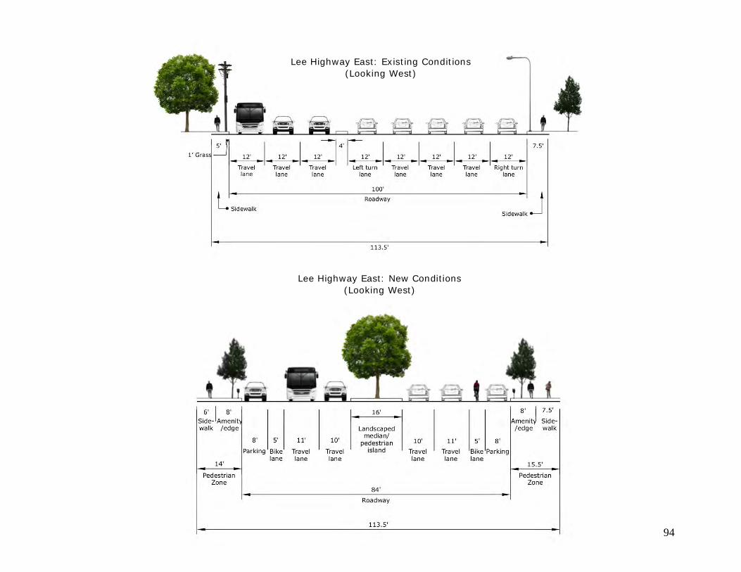
94
Lee Highway East: Existing Conditions (Looking West)
Lee Highway East: New Conditions (Looking West)
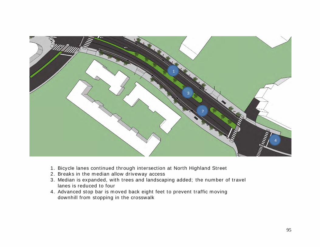
95
2
1
4
1. Bicycle lanes continued through intersection at North Highland Street 2. Breaks in the median allow driveway access 3. Median is expanded, with trees and landscaping added; the number of travel
lanes is reduced to four 4. Advanced stop bar is moved back eight feet to prevent traffic moving
downhill from stopping in the crosswalk
3
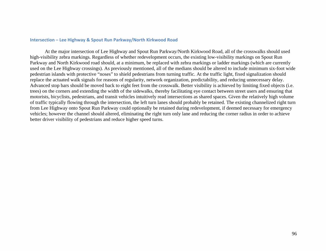
96
Intersection–LeeHighway&SpoutRunParkway/NorthKirkwoodRoad
At the major intersection of Lee Highway and Spout Run Parkway/North Kirkwood Road, all of the crosswalks should used high-visibility zebra markings. Regardless of whether redevelopment occurs, the existing low-visibility markings on Spout Run Parkway and North Kirkwood road should, at a minimum, be replaced with zebra markings or ladder markings (which are currently used on the Lee Highway crossings). As previously mentioned, all of the medians should be altered to include minimum six-foot wide pedestrian islands with protective “noses” to shield pedestrians from turning traffic. At the traffic light, fixed signalization should replace the actuated walk signals for reasons of regularity, network organization, predictability, and reducing unnecessary delay. Advanced stop bars should be moved back to eight feet from the crosswalk. Better visibility is achieved by limiting fixed objects (i.e. trees) on the corners and extending the width of the sidewalks, thereby facilitating eye contact between street users and ensuring that motorists, bicyclists, pedestrians, and transit vehicles intuitively read intersections as shared spaces. Given the relatively high volume of traffic typically flowing through the intersection, the left turn lanes should probably be retained. The existing channelized right turn from Lee Highway onto Spout Run Parkway could optionally be retained during redevelopment, if deemed necessary for emergency vehicles; however the channel should altered, eliminating the right turn only lane and reducing the corner radius in order to achieve better driver visibility of pedestrians and reduce higher speed turns.
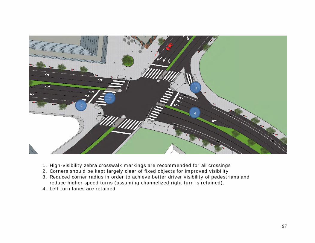
97
1
2
3
4
1. High-visibility zebra crosswalk markings are recommended for all crossings 2. Corners should be kept largely clear of fixed objects for improved visibility 3. Reduced corner radius in order to achieve better driver visibility of pedestrians and
reduce higher speed turns (assuming channelized right turn is retained). 4. Left turn lanes are retained
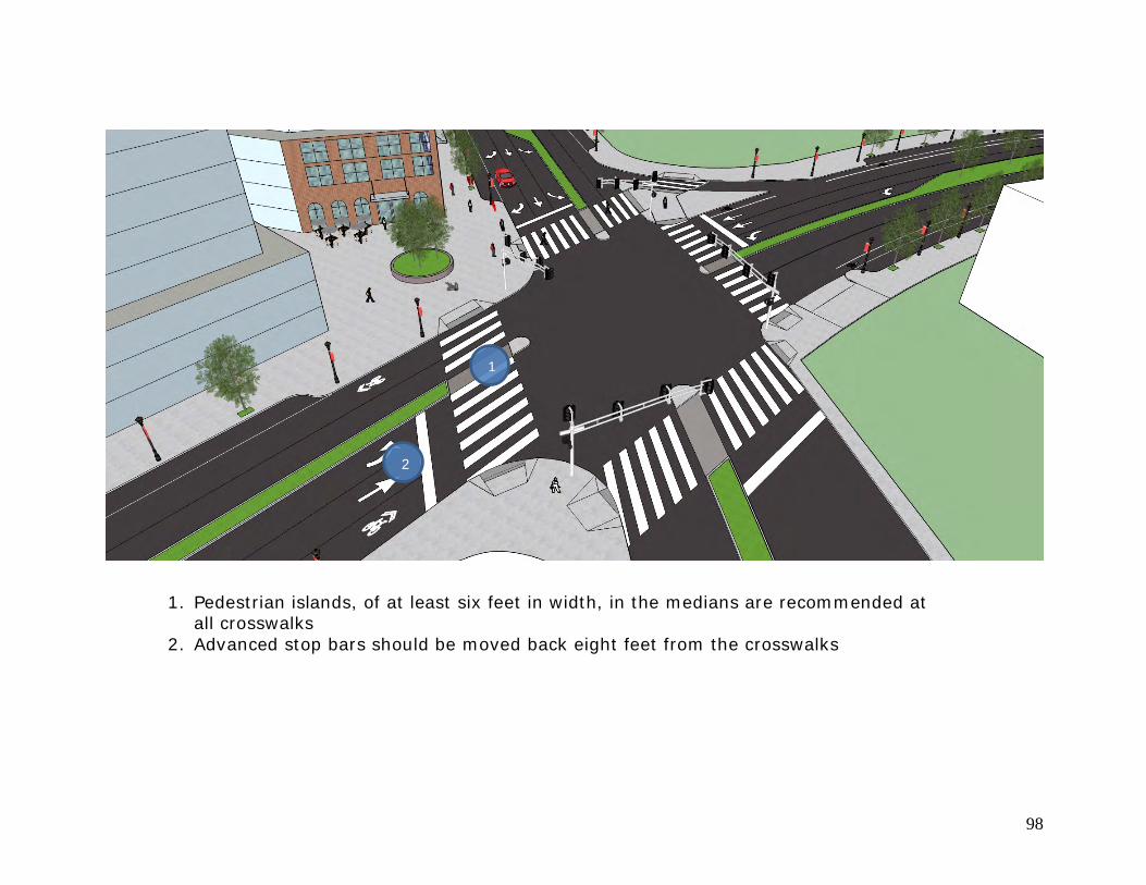
98
1
2
1. Pedestrian islands, of at least six feet in width, in the medians are recommended at all crosswalks
2. Advanced stop bars should be moved back eight feet from the crosswalks
99
References Arlington County GIS Mapping Center. (2015). Roads [GIS data]. Retrieved from http://gisdata.arlgis.opendata.arcgis.com/ Arlington County Government. (2016). “Smart Growth” https://projects.arlingtonva.us/planning/smart-growth/ Arlington Virginia, Department of Environmental Services. (2007). Arlington Master Transportation Plan – Goals and Policies Summary. Arlington, VA:
Author. Retrieved from http://arlingtonva.s3.amazonaws.com/wp-content/uploads/sites/31/2014/02/DES-MTP-Goals-and-Policies-Summary.pdf Arlington Virginia, Department of Environmental Services. (2008). Arlington Master Transportation Plan – Bicycle Element. Arlington, VA: Author. Retrieved
from http://arlingtonva.s3.amazonaws.com/wp-content/uploads/sites/31/2014/02/DES-MTP-Bicycle-Element.pdf Arlington Virginia, Department of Environmental Services. (2009). Arlington Master Transportation Plan – Parking and Curb Space Management. Arlington,
VA: Author. Retrieved from http://arlingtonva.s3.amazonaws.com/wp-content/uploads/sites/31/2014/02/DES-MTP-Parking-and-Curb-Space-Management-Element.pdf
Arlington Virginia, Department of Environmental Services. (2008). Arlington Master Transportation Plan – Pedestrian Element. Arlington, VA: Author.
Retrieved from http://arlingtonva.s3.amazonaws.com/wp-content/uploads/sites/31/2014/02/DES-MTP-Pedestrian-Element.pdf Arlington Virginia, Department of Environmental Services. (2011). Arlington Master Transportation Plan – Streets Element. Arlington, VA: Author. Retrieved
from http://arlingtonva.s3.amazonaws.com/wp-content/uploads/sites/31/2014/02/DES-MTP-Streets-Element.pdf Arlington Virginia, Department of Community Planning, Housing, and Development. (2015a). Lee Highway
Briefing Book. Retrieved from http://arlingtonva.s3.amazonaws.com/wp-content/uploads/sites/31/2015/02/Lee-Highway-briefing-book-final-022415.pdf Arlington Virginia, Department of Community Planning, Housing, and Development. (2015b). Lee Highway
Visioning Charrette: Charrette Kickoff Meeting [PDF of PowerPoint slides]. Retrieved from http://arlingtonva.s3.amazonaws.com/wp-content/uploads/sites/31/2015/11/LeeHighway_KickoffPresentation_2015-1106.pdf
Arlington Virginia, Department of Community Planning, Housing, and Development. (2015c). Lee
Highway: County Planning and Existing Conditions, presentation for Lyon Village Civic Association [PDF of PowerPoint slides]. Retrieved from http://arlingtonva.s3.amazonaws.com/wp-content/uploads/sites/31/2014/12/LeeHighway_Presentation-2014-1202LV.pdf
Bassett, D. Jr., Pucher, J., Buehler, R., Thompson, D.L., & Crouter, S.E. (2008). Walking, Cycling, and Obesity Rates in Europe, North America, and Australia.
Journal of Physical Activity and Health, 5, 795-814. Clifton, K., Livi, A., & Rodríguez, D. (2004). Pedestrian Environment Data Scan (PEDS). University of North Carolina. Retrieved from
http://planningandactivity.unc.edu/PEDS%20Instrument%20v.2.pdf
100
Cortright, J. (2009). Walking the Walk: How Walkability Raises Home Values in U.S. Cities. CEOs for Cities. Retrieved from http://www.reconnectingamerica.org/assets/Uploads/2009WalkingTheWalkCEOsforCities.pdf
Dover, Kohl & Associates. (2016). Lee Highway Visioning Study, Draft 02.04.16. Retrieved from
http://arlingtonva.s3.amazonaws.com/wp-content/uploads/sites/31/2016/02/LeeHwy_Visioning-Report_2016-0204_Lores.pdf Ewing, R., Schmid, T., Killingsworth, R., Zlot, A., & Raudenbush, S. (2003). Relationship Between Urban Sprawl and Physical Activity, Obesity, and
Morbidity. American Journal of Health Promotion, 18(1), 47-57. Ewing, R. Pedestrian- and Transit-Oriented Design: A Primer for Smart Growth. Smart Growth Network. Retrieved from
http://www.fta.dot.gov/documents/ptfd_primer.pdf Frank, L.D., Greenwald, M.J., Kavage, S., & Devlin, A. (2011). An Assessment of Urban Form and Pedestrian and Transit Improvements as an Integrated GHG
Reduction Strategy. Seattle, WA: Washington State Department of Transportation. Retrieved from http://www.wsdot.wa.gov/research/reports/fullreports/765.1.pdf
Institute of Transportation Engineers. (2004). Promoting Sustainable Transportation Through Site Design. Washington, DC: Author. Retrieved from
http://www.cite7.org/resources/documents/ITERP-PromotingSustainableTransportationThroughSiteDesign.pdf Institute of Transportation Engineers, and Congress for the New Urbanism. (2010). Designing Walkable Urban Thoroughfares: A Context Sensitive Approach.
Washington, DC: Institute of Transportation Engineers. Retrieved from http://library.ite.org/pub/e1cff43c-2354-d714-51d9-d82b39d4dbad Lee Highway Alliance. (2014). http://www.leehighwayalliance.com Leinberger, C.B., & Alfonzo, M. (2012). Walk this Way: The Economic Promise of Walkable Places in Metropolitan Washington, D.C. Washington, DC:
Brookings Institute. Retrieved from http://www.brookings.edu/research/papers/2012/05/~/media/Research/Files/Papers/2012/5/25%20walkable%20places%20leinberger/25%20walkable%20places%20leinberger.pdf
National Association of City Transportation Officials. (2013). Urban Street Design Guide. Washington, DC: Island Press. Pucher, J., & Buehler, R. (2010). Walking and Cycling for Healthy Cities. Built Environment, 36(4), 391- 414. Pucher, J., & Dijkstra, L. (2000). Making Walking and Cycling Safer: Lessons from Europe. Transportation Quarterly, 54(3), 25-50. Renaissance Planning. (2015). Lee Highway Multimodal Needs Assessment. Retrieved from
http://arlingtonva.s3.amazonaws.com/wp-content/uploads/sites/31/2015/07/LeeHwyTLC_ReportwithAppendices_7.2.15-Compressed.pdf Tolley, R. (2011). Good For Busine$$ - The Benefits Of Making Streets More Walking And Cycling Friendly. National Heart Foundation of Australia. Retrieved
from https://heartfoundation.org.au/images/uploads/publications/Good-for-business.pdf
101
Tomalty, R., & Haider, M. (2009). 2009 BC Sprawl Report: Walkability and Health. Vancouver, BC: Smart Growth BC. Victoria Transport Policy Institute. (2015a). TDM Encyclopedia, “Complete Streets: Designing Roads For Diverse Modes, Users and Activities.”
http://www.vtpi.org/tdm/tdm133.htm Victoria Transport Policy Institute. (2015b). TDM Encyclopedia, “Walkability Improvements: Strategies to Make Walking Convenient, Safe and Pleasant.”
http://www.vtpi.org/tdm/tdm92.htm Virginia Department of Rail and Public Transportation. (2013). Multimodal System Design Guidelines. Richmond, VA: Author. Retrieved from
http://www.drpt.virginia.gov/media/1055/drpt_mmsdg_final_full.pdf
Virginia Department of Transportation. (2014). Virginia Department of Transportation Daily Traffic Volume Estimates Including Vehicle Classification Estimates: Jurisdiction Report 00. Richmond, VA: Author. Retrieved from http://www.virginiadot.org/info/resources/Traffic_2014/AADT_000_Arlington_2014.pdf.
![Walkable Katipunan 1penoy.admu.edu.ph/~pedlab/wp-content/.../2014/10/Walkable-Katipu… · Microsoft PowerPoint - Walkable Katipunan 1 [Compatibility Mode] Author: Teknomo Created](https://img.pdfslide.us/doc/110x75/601a4955d3ffd756a8146466/walkable-katipunan-pedlabwp-content201410walkable-katipu-microsoft-powerpoint.jpg)