Embed Size (px)
Citation preview

TURLEYASSOCIATES
GLENMONANon-Technical Summary
SEPTEMBER 2010
Environmental Statement
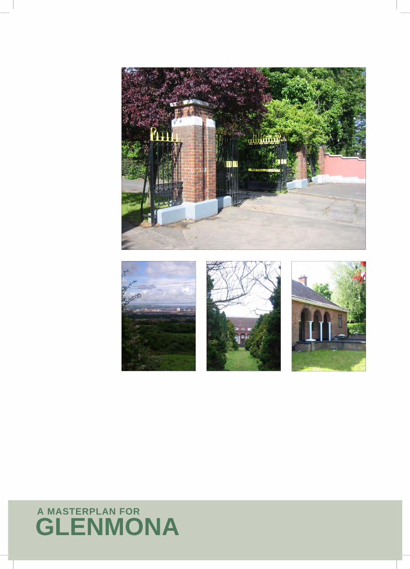
GLENMONAA MASTERPLAN FOR

TURLEYASSOCIATES
Non-Technical Summary
Introduction page 1
Site and Surroundings page 1
Project Description page 2
Concept Masterplan page 3
Planning Context page 4
Population page 5
Transportation page 6
Land, Soils and Water page 8
Ecology page 9
Noise page 10
Air and Climate page 10
Archaeology page 11
Landscape Character and Visual Impact page 12
Overall Assessment page 14

GLENMONAA MASTERPLAN FOR
Aerial photograph with red line
N

TURLEYASSOCIATES
Introduction
This is a Non-Technical Summary of an Environmental Statement (ES), prepared to accompany an application for outline planning permission for a residential led mixed–use development at the former St Patrick’s site (Glenmona) off the Monagh By-Pass/Glen Road.
The ES is a detailed report which articulates the Environmental Impact Assessment (EIA) undertaken by the project team. It provides an assessment of the likely environmental effects and their significance and sets out mitigation measures to address any potentially adverse impacts of the proposal.
The masterplanning for the site has been informed by a range of comprehensive studies undertaken on the site, which, in turn, have assisted in devising the form, type and configuration of the mix of uses proposed for this key regeneration opportunity. The masterplan is produced within this document to provide a clear understanding of what is proposed for the site.
This document is a summary of the main ES, produced in an easy to understand format to enable members of the public and all key stakeholders to readily understand the proposals and the process which has been engaged in to robustly assess the potential environmental impacts which the proposal may give rise to. Site and Surroundings
The site represents one of the largest development opportunity sites within West Belfast. It lies within the development limits of the City and is defined to the north by the Upper Springfield Road, to the east by the Monagh By-Pass, to the south by the Glen Road and to the west by established housing development, open space and St Mary’s Grammar School.
The site extends to approximately 34.4 ha (85 acres). It comprises underused, urban fringe land with three children’s care units on site, an administration building and four private residential buildings.
The surrounding area to the east and south of the site is predominately residential. St Theresa’s Primary School lies due east of the entrance to the site and a religious establishment (St John of God) lies to the west of the entrance.
Other land uses in the vicinity of the site include the Inbev brewery site to the west and Christian Brothers Secondary School to the south.
Site Context plan
GLEN ROAD
GLEN ROAD
ANDERSONSTOWN ROAD
SUFFOLK ROAD
GLEN ROAD
UPPER SPRINGFIELD ROAD
MONAGH BY PASS
KENNEDY
WAY
STOCKMANS LANE
M1
M1
RO
AD
FALL
S
FALL
S RO
AD
N
Existing Glenmona Homes
N
page 1

GLENMONAA MASTERPLAN FOR
Project Description
The fundamental objective of the Concept Master Plan (CMP) which has emerged from the masterplanning process is to demonstrate that the application lands can be developed in a sustainable manner, sympathetic to the surrounding context and provide a quality of living and working environment which will deliver important regeneration benefits for the people of this part of Belfast.
The proposed development comprises the following mix of uses:
• 600 dwellings, made up of 50% private and 50% social and affordable;
• 4,000 sq m community/cultural;
• 2,000 sq m light industry;
• 2,000 sq m offices;
• 1,600 sq m retail;
• 1,000 sq m professional services;
• 600 pupil secondary school (4 form entry, 5 years, 30 pupils per class);
• 120 bedroom hotel;
• 3 No. intensive support homes; and
• 8 bed mainstream care home.
N
Land Use Plan
page 2

TURLEYASSOCIATES
Concept Masterplan
The Vision and driving principles for the proposed redevelopment of the Glenmona site are asfollows:
• Delivery of an ‘urban village’ with residential, employment and community uses;
• Creation of a sustainable development highly connected to the surrounding context;
• Creation of a development which exhibits best practice in urban design and architecture;
• Protection of the environment balanced with the delivery of a green and sustainable development; and
• Provision of opportunities for learning, enterprise, recreation, healthcare and children’s homes.
To provide the level of detail necessary to allow for full description of the project and a robust assessment of its likely significant environmental effects, the masterplan for the site has been translated into a parameters plan. The general approach to the parameters plan has been to provide an indication of the disposition, location and mix of land uses, together with their respective building heights.
N
Parameters plan for the Glenmona Urban Village
page 3

GLENMONAA MASTERPLAN FOR
Planning Context
The proposed development has been thoroughly considered against current planning policy.
The site is located within the north and west Belfast axis within the Regional Development Strategy which is identified as a focus for regeneration.
The proposed development has significant positive regenerative implications which will deliver a major enhancement for the area in physical, environmental, social and economic terms. It is entirely in tune with the thrust of regional planning policy.
The urban village concept for the site is underpinned by sustainability principles and will deliver a quality and desirable place to live, work and visit. The proposed development will create a vibrant community with a mix of uses including residential, employment, leisure, community and retail.
The proposals will contribute to the housing land supply in West Belfast, delivering increased residential use within the urban area in a location which is convenient to public transport. It responds to the site and its setting, embracing public transport usage and reduced reliance on the private car.
The proposals are consistent with the agreed position between the objectors and the Department at the draft Belfast Metropolitan Area Plan Inquiry in that the site should be zoned as mixed use rather than for industry. Employment generation is the key driver behind the mixed use scheme and the proposals will have significant beneficial impacts for the local economy.
The Environmental Statement has been prepared in accordance with the prevailing Environmental Impact Assessment Regulations. A number of environmental topic areas have formed part of this assessment. All aspects of planning policy have influenced the range of land uses proposed and the environmental impact assessment which is summarised as follows.
General Principles
Planning Policy Statement 1
page 4

TURLEYASSOCIATES
Population
A base line survey of existing social and community facilities, employment and socio-economic statistics were considered in the formulation of this ES. An assessment of the potential impacts of the proposal on education, employment and local facilities was then undertaken. Further focus was given to the economic impact of the proposal through an Economic Impact Assessment prepared by Oxford Economic.
Given the types of facilities and residential numbers proposed an anticipated population for the new development was established and typical jobs and revenue associated with the proposed facilities were calculated.
Impacts arising from the development will include:
• A positive increase in employment of approximately 400 over the course of the development.
• The creation of new local facilities including cultural and community attractions.
• Increase in population in the area to support local schools and businesses.
• A positive cultural and tourism impact for West Belfast and beyond with attraction of additional visitors to the area.
• Sensitive development of a prominent undeveloped site within the local area.
Overall it is considered that the proposal will have a long term substantial beneficial impact on the local social infrastructure and economy.
Site location and local facilities
N
page 5

GLENMONAA MASTERPLAN FOR
Transportation
Current traffic volumes on the surrounding highway network and the increase in traffic movements as a result of the proposed development have been examined and predicted.
The assessment follows the approach set out in the Transport Assessment Guidelines published in 2006. The Guidelines published by the Institution of Highways & Transportation in 1994, and Guidelines published by the Department of Regional Development, Roads Service in 2001 have also been considered.
Person trips generated by the proposed development have been determined using a recognised database.
It is possible to introduce certain measures as part of good site design to encourage sustainable transport modes. The assessment therefore examines proposals for enhancing the attractiveness of public transport, walking, and cycling, and outlines the restrictions imposed to curtail the use of private cars.
Existing Bus Routes
N
To examine the impact of residual generated traffic flows, generated traffic has been distributed according to population/employment figures within a 20 kilometre radius, derived from local census information and a Traffic Impact Assessment has also been conducted.
RPS Consulting Engineers conducted traffic surveys to assess the existing traffic conditions at strategic points on the local road network. National Road Traffic Forecast (NRTF) low growth rates have been applied to counted traffic data in order to forecast flows for the relevant assessment years.
There are several applications in the area which may impact on the local road network. Traffic flows from their associated and approved Traffic Impact Assessments have been added to existing flows to produce the base model.
page 6
TURLEYASSOCIATES
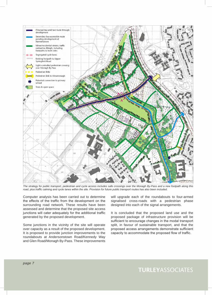
The strategy for public transport, pedestrian and cycle access includes safe crossings over the Monagh By-Pass and a new footpath along this road, plus traffic calming and cycle lanes within the site. Provision for future public transport routes has also been included.
N
Computer analysis has been carried out to determine the effects of the traffic from the development on the surrounding road network. These results have been assessed and determine that the proposed site access junctions will cater adequately for the additional traffic generated by the proposed development.
Some junctions in the vicinity of the site will operate over capacity as a result of the proposed development. It is proposed to provide junction improvements to the roundabouts at Andersonstown Road/Kennedy Way and Glen Road/Monagh By-Pass. These improvements
will upgrade each of the roundabouts to four-armed signalised cross-roads with a pedestrian phase designed into each of the signal arrangements.
It is concluded that the proposed land use and the proposed package of infrastructure provision will be sufficient to encourage changes in the modal transport split, in favour of sustainable transport, and that the proposed access arrangements demonstrate sufficient capacity to accommodate the proposed flow of traffic.
page 7

GLENMONAA MASTERPLAN FOR
Land, Soils and Water
A study of the ground conditions and contamination was undertaken to understand the baseline conditions of the soils, geology, hydrology and hydrogeology at the application site. This was then followed by an assessment of potential impacts and identification of possible mitigation measures.
The soils on the site have been classified as urban soil and are not considered to be ‘Best and Most Versatile’ agricultural land. They have been disturbed across the site mainly through agriculture, construction and demolition of buildings, infrastructure and playing fields and deposition of made ground. Soils on the site are underlain by glacial till deposits which in turn are underlain by Mercia Mudstone.
The site is located within the Blackstaff River catchment. The only significant hydrological feature on the site is a small stream with issues on site which has been partially culverted. Bedrock underlying the site is impermeable and does not contain any significant groundwater potential. Low permeability drift deposits overlying the bedrock limit the migration of contaminants through the subsurface, resulting in low vulnerability of the existing groundwater to contamination.
On the basis of the information available, the proposed development would have a potentially minor to neutral impact on the local soils and geology. The potential impacts on soils due to loss and compaction are not considered of significance given the absence of ‘Best and Most Versatile’ agricultural land and the historically disturbed character of soils. Good site practice during the construction phase will minimise any risks of soil contamination.
The proposed development would have a potentially minor to moderate impact on the local hydrological and hydrogeological regime. This is primarily due to the absence of any sensitive surface water or groundwater features on the site and the highly urbanised environment found immediately downstream of the site. The main potential impact on the catchment is an increase in the rate and volume of runoff associated with the increase in impermeable surfaces due to the development. This must be attenuated to pre development levels.
This attenuation can be achieved by implementing a Sustainable Urban Drainage Systems (SuDS). SuDS will also provide treatment of this surface water runoff to prevent any deterioration in surface or groundwater quality. Additionally the implementation of SuDS wetlands/ponds will provide an opportunity to enhance the habitat within the site itself.
It is proposed to restore the stream on site by opening the existing culvert. This also provides an opportunity to enhance the habitat within the site.
N
Slope analysis and internal site contours
page 8

TURLEYASSOCIATES
Ecology
An assessment of the potential impacts of the proposed development upon the ecology of the site was carried out following the standard Ecological Impact Assessment (EcIA) method developed by the Institute of Ecology and Environmental Management.
Baseline information, consultation with statutory and non-statutory bodies was undertaken and field work carried out. Fieldwork consisted of an Extended Phase 1 Habitat Survey plus bat, badger, red squirrel and breeding bird surveys.
These surveys showed that habitats on the application site were of generally low ecological value, apart from the hedgerows which were species rich and the broad-leaved woodlands. These were assessed as having local value to West Belfast.
Three species of bats, Common pipistrelle, Soprano pipistrelle and Leisler’s bat were found to be using the site for foraging and commuting. No evidence was collected to suggest these species were roosting within the application site. Badgers or red squirrels were not found at the application site during the surveys. With regard to birds, 30 species of bird were identified including 11 species of Conservation Concern. As a consequence of the survey information the Conservation Value of the application site was assessed as being of local ecological conservation value with the commuting route for bats being considered of national conservation value.
N
Habitat plan
Bat Transect Map
NPotential impacts predicted from the proposed development were assessed as being direct habitat loss, severance, loss of life, physical disturbance and noise disturbance.
The significance of these potential impacts ranged from Low (adverse) to Moderate (adverse) and most likely to impact upon foraging and commuting bats, foraging and nesting birds and natural habitat in the application site that is of general value to wildlife.
Mitigation measures to address the impacts have been developed. These relate to both the construction and operational phases of the proposed development. In light of the mitigation measures outlined in the ES, the significance of the impacts will be reduced to Low (adverse) – Neutral/negligible.
page 9

GLENMONAA MASTERPLAN FOR
Noise
An assessment of the potential impacts of the proposed development upon existing and future sensitive receptors from construction processes and traffic related noise sources was carried out.
Each section of the assessment was made in accordance with the associated guidance documents as follows:
• Sensitive receptors - Planning Policy Guidance 24
• Traffic - The Calculation of Road Traffic Noise manual
• Construction – BS 5228 & Defra guidance
The assessment found the site to have elevated levels of noise at locations along the Monagh Bypass, Upper Springfield Road and Glen Road at present. The development layout has been prepared to reflect the observed traffic noise and the assessment advised that the design of future properties should incorporate noise attenuating glazing to reduce noise levels in affected properties. The noise levels for people living and working within the completed development are predicted to be acceptable.
Traffic noise was assessed on traffic flow figures, which were processed using the prediction method of the guidance to produce an estimation of noise levels on future properties from vehicle movements. The assessment concluded the impact on the proposed development from traffic noise would be minor due to the existing noise climate of the surrounding area.
Construction noise was assessed for each part of the construction process. Generally the noise impact during construction is predicted to be minor. However, where construction work is required to be undertaken adjacent to the adjoining residential dwellings the short term impact was assessed to be moderate. The impact of construction noise will be minimised by adopting good site practice and through careful planning and effective work scheduling.
Air and Climate
The Air Quality Assessment looked at the potential impact from traffic generated by the proposed development of the Glenmona site. Modelling was carried out for five receptors at three junctions where traffic could potentially impact on air quality, following consultation with Belfast City Council’s Environmental Health Department.
The Highways Agency’s The Design Manual for Roads and Bridges (DMRB) Vol.11 screening method spreadsheet model, version 1.02 (November 2003), has been used to model the air quality. The model can be used to predict concentrations of nitrogen oxides (NOX), nitrogen dioxide (NO2), particulates (PM10), carbon monoxide (CO), benzene and 1, 3-butadiene through the use of empirical statistics derived from the analysis of monitored data in the UK. Potential air quality impacts were modelled for 2009, year of completion, and 2010.
Traffic impacts on air quality were assessed against traffic data generated from the Traffic Impact Assessment undertaken by RPS Consulting Engineers.
Following modelling of the potential air quality impacts comparison was made of the results against the Air Quality Objectives in the Air Quality Regulations 2000 and (Amendment) Regulations 2002. The air quality impact assessment concluded that the current air quality background levels in the vicinity of the site were within the objective levels set by the Regulations and that the impacts from the development traffic would cause long term insignificant increases in the air quality parameter levels, but would not cause any exceedences of the objectives.
Noise monitoring locations
N
page 10

TURLEYASSOCIATES
Archaeology
Archaeological assessment of the proposed site comprised a detailed desktop survey and a fieldwalk.
One known SMR feature ANT 060:063 falls into the overall proposed area. Although the archaeological nature of this feature is questionable, impact on it will be avoided in the proposed layout. Impact on traces of ruins of a long-standing building cluster called Woodlands noted on maps within the proposed area is of interest but not a major issue. While the cluster seems to have been present since the later 18th century and one long-standing building may have originated at that time, the remains are very fragmentary today and of unclear date.
The removal of these traces is considered a minor impact that could be offset by a simple strategy of survey and recording of the remains and/or monitoring. The general area of the proposed site and the environmental niche in which it is located seem to have been most attractive to settlers during the Early Christian period.
Known archaeological sites within 2km radius of site.
202
Figure 11.7 O.S. 4th edition 6-inch map, Antrim sheet 60 (1947).
11.54 The farm complex in the northern tip of the site had expanded into a large complex of more than six buildings named ‘Viola’. Of the buildings in the north-west, only one long structure now remained, here named ‘Woodlands’. Other buildings to the west side of this are excluded from the application site. The final group of buildings to the east of this now consisted of four structures, still unnamed. The two streams crossing the central portion of the site had been combined to form one channel, switching back and forth between the two original courses. The hachured area (Ant 060:063) within the proposed site, close to the Glen Road is discussed in detail elsewhere in this report and is more easily seen on 1:2500 OS map of 1938. Beyond the proposed site this map showed development along the Glen Road, the first signs of the city spreading to this area. St Theresa’s School and RC Church were both in place to the south-east of the site at this time.
Site location 1947
N
page 11
Consequently, theoretical archaeological potential and, therefore, theoretical impact is possible. However, any such possible impact on unknown subsurface remains threatened by invasive works can be offset by standard archaeological mitigation measures such as monitored stripping, monitoring invasive works etc.
N

GLENMONAA MASTERPLAN FOR
Landscape Character and Visual Impact
The site is situated in a transitional zone between the dense residential areas of West Belfast and the foothills of the Belfast Basalt Escarpment which is an Area of High Scenic Value.
A detailed landscape and visual assessment of the area was undertaken which assessed the most significant impact resulting from the proposed development as being the potential urbanisation of open countryside in the vicinity of the Upper Springfield Road and the encroachment of development on to the lower slopes of the basalt escarpment; resulting in a degradation of views from distant receptors as far afield as Castlereagh in southeast Belfast. The slope is a prominent landmark of the area and its open character, distinct profile and high visibility render it particularly sensitive to change.
However, the site is within the development limits and there are comparatively few visual receptors within 1km of the site. Locally the site is well contained and there are very few close proximity views of the proposed development area. In order to reduce the potential landscape and visual impacts on the upper slope it is proposed to concentrate more intensive development on less sensitive central and lower parts of the application area with less intensive development on the upper slopes together with significant planting.
Overall the proposals would result in the loss of approximately 19.5ha of pasture, 8ha of amenity grassland and some hedgerows. There would be comparatively few trees lost to the development and no public rights of way would be directly affected. In addition the development would provide increased opportunities for pedestrian links to the Belfast Hills.
The development provides the opportunity to introduce a strong landscape/townscape structure that would help unify the surrounding (and often conflicting) land-uses. The development also provides the opportunity to create a well defined defensible edge to the west of Belfast.
The Landscape and Open Space Plan
N
page 12

TURLEYASSOCIATES
Landscape and Visual Analysis
page 13

GLENMONAA MASTERPLAN FOR
Overall Assessment
The proposal has evolved through a detailed analysis of the site in terms of its assets, constraints and development potential. The EIA process has been undertaken to ensure the interactions between the potential effects have been properly considered and addressed through mitigation.
The long term environmental implications of the proposal are generally beneficial. These include provision of new housing, employment and local facilities in a highly sustainable location, provision of open space, improvement of site drainage and delivery of enhanced physical, social and environmental infrastructure.
Density plan
N
page 14
Following mitigation there will, however, be some adverse residual environmental effects. In geographical terms it is considered that these will be of localised nature and not exceed a low-moderate rating in terms of their significance. Adverse impacts will include increases in vehicular flows, construction noise, loss of vegetation features and landscape changes.

TURLEYASSOCIATESpage 15
The Environmental Statement and other information may be inspected at:
Central Library, Royal Avenue, Belfast
West Belfast Partnership Board, 218 – 226 Falls Road, Belfast
Glenmona Resource Centre, Administration Building, Glen Road, Belfast Copies of the Environmental Statement may be purchased from the offices of Turley Associates, 29 - 31 Montgomery Street, Belfast, BT1 4NX (Tel: 028 90 897400, e-mail [email protected]). The price is £150 inclusive of postage and packaging. Copies of the Concept Masterplan may also be purchased priced £50 inclusive of postage and packaging