Embed Size (px)
Citation preview
Environmental Impact Assessment STORAGE/USE OF DREDGED MATERIAL FOR NASSAU HARBOUR PORT IMPROVEMENT PROJECT, NASSAU, BAHAMAS. DRAFT 16 April 2009 Prepared for Cox & SHAL Consultants and the Government of the Bahamas Prepared by
Blue Engineering Ltd. For further information please contact Michelle Lakin at (242) 32-47850 650 east Bay Street, P. O. Box SS6328
Nassau, BahamasI

Environmental Impact Assessment, Storage/Use of Dredged Material for Nassau Harbour Port Improvement Project, Nassau, Bahamas
DRAFT 00, April 16, 2009 1
TABLE OF CONTENTS TABLE OF CONTENTS 1 EXECUTIVE SUMMARY 5 1. INTRODUCTION 1.1 Introduction and objectives 6 1.2 Storage/use of dredged material works and Environmental Impact Assessment (EIA) 6 1.3 Project Rationale 6 1.4 Terms of Reference 7 1.5 Methodology 7
1.5.1 Sediment and marine benthic surveys 7 1.5.2 Terrestrial 7 1.5.3 Water quality 7 1.5.4 Currents, waves and shorelines 8
1.5.4.1 Currents 1.5.4.2 Waves and shorelines
1.5.5 Socio-economic 8 1.5.6 Archaeology 8 1.5.7 Land based traffic 8 1.5.8 Marine traffic 9
2. PROPOSED STORAGE/USE OF DREDGED MATERIAL PROJECT 2.1 Volumes and types of sediments to be stored/used 9 2.2 Dredged material storage/use plan 9 2.3.1 Dredged material and water contamination 9 2.3.2 Storage/use of dredged materials equipment and methodology 9 2.5 Storage/use of dredged materials 10
2.5.1 Storage of dredged materials 11 2.5.2 Disposal of water from dredged material 11 2.5.3 Use of dredged materials 13 2.5.4 Duration of stockpiling works 15 2.5.5 Completion of use of stockpiled material 15 2.5.6 Land use following storage/use of dredged material 15
3. PROJECT SETTING 3.1 Physical Environment 15
3.1.1 Geomorphology and Bathymetry 15 3.1.2 Subsurface conditions 16
3.1.2.1 Dredged material3.1.2.2 Arawak Cay subsurface conditions 3.1.3 Climate 18 3.1.4 Wind 18 3.1.5 Storms 20 3.1.6 Waves 21
3.1.6.1 Offshore Deep-water Waves 3.1.6.2 Inshore Coastal Waves
3.1.7 Tides 21 3.1.8 Currents 21
3.1.8.1 Offshore Deep-water Currents 3.1.8.2 Inshore Coastal Currents
Environmental Impact Assessment, Storage/Use of Dredged Material for Nassau Harbour Port Improvement Project, Nassau, Bahamas
DRAFT 00, April 16, 2009 2
3.1.9 Surface drainage 22 3.1.10 Marine water quality 22
3.2 Biological Environment 25 3.2.1 Terrestrial ecology 25 3.2.2 Aquatic/Marine Habitats 27 3.2.3 Protected areas 28
3.3 Socio-economic and Cultural Environment 30 3.3.1 Demography 30 3.3.2 Land use 31 3.3.3 Education 32 3.3.4 Employment 32 3.3.5 Economic Activities 32
3.3.5.1 Tourism 3.3.5.2 Commerce 3.3.5.3 Shipping 3.3.5.4 Fishing 3.3.5.5 Diving/Snorkeling 3.3.6 Natural and technological hazard vulnerability
4. ENVIRONMENTAL ORGANISATIONS, POLICY, LEGISLATION AND REGULATORY FRAMEWORK 35
5. POTENTIAL ENVIRONMENTAL IMPACTS 5.1 Potential Geographic and Physical Impacts 38
5.1.1 Land Use and Topography 38 5.1.1.1 Displacement of Current Land Uses 5.1.1.2 Compatibility with Existing and Future Land Demands 5.1.1.3 Alteration of Natural Landforms and Topography
5.1.2 Meteorological and Climatic Conditions 41 5.1.3 Geology 41
5.1.3.1 Beach and Shoreline Stability 5.1.3.2 Soil Erosion and Sedimentation 5.1.3.3 Preservation of Unique Geologic Features
5.1.4 Stormwater Runoff 43 5.1.5 Groundwater Resources 43
5.1.5.1 Alteration of Groundwater Recharge and Flow 5.1.5.2 Deterioration of Groundwater Quality Associated with Nutrient Loading and Potential
Contamination 5.1.5.3 Effect on Existing and Future Water Supplies
5.1.6 Marine Water Resources 45 5.1.6.1 Oceanographic Conditions 5.1.6.2 Bathymetry 5.1.6.3 Tides and Currents 5.1.6.4 Marine Water Quality
5.1.7 Air Quality and Noise 53 5.1.7.1 Impacts from Fuel Loading and Unloading Operations 5.1.7.2 Emissions from Stationary and Uncontrolled Sources 5.1.7.3 Emissions from Mobile Sources 5.1.7.4 Effects of Construction Noise and Dust
5.2 Potential Biological Resource Impacts 57 5.2.1 Terrestrial Biological Resources 57
5.2.1.1 Clearing of Vegetation 5.2.1.2 Risk of Introduction of Non-native Species, Foreign Diseases, and Escape of Pets
Environmental Impact Assessment, Storage/Use of Dredged Material for Nassau Harbour Port Improvement Project, Nassau, Bahamas
DRAFT 00, April 16, 2009 3
5.2.1.3 Impacts to Wildlife Habitat 5.2.1.4 Impacts to Threatened and Protected Species and Migratory Birds
5.2.2 Aquatic/Marine Biological Resources 58 5.2.2.1 Impacts to Aquatic/Marine Habitat 5.2.2.2 Impacts to Aquatic/Marine Biota Associated with Deterioration of Water Quality 5.2.2.3 Effects of Using Fertilizers, Biocides, and Pesticides on Aquatic/Marine Biota 5.2.2.4 Impacts to Biota Associated with Boating, Fishing and Other Recreational Activities 5.2.2.5 Impacts to Aquatic/Marine Biota Associated with Oil Spills 5.2.2.6 Impacts to Commercially Important Species and Habitats
5.3 Potential Socioeconomic and Cultural Impacts 62 5.3.1 Demographics 63
5.3.1.1 Displacement and Resettlement of Existing Housing 5.3.2 Economic Activities 63
5.3.2.1 Effect on Direct and Indirect Employment 5.3.2.2 Impact on Existing and Future Fishing and Fisheries Exploitation 5.3.2.3 Impacts on Public Health and Worker Health and Safety
5.3.3 Tourism 65 5.3.3.1 Effect on Existing and Future Land Use Values 5.3.3.2 Impacts to Shipping and Boating 5.3.3.3 Impacts on Public Access and Use of Coastal Resources 5.3.3.4 Effects on Availability or Demand for Local Infrastructure
5.3.4 Cultural Resources 67 5.3.4.1 Disturbance to Cultural Resources
5.3.5 Visual/seascape impacts 67 5.6.5.1 Visual Character 5.3.5.2 Highway Sightlines and Views 5.3.5.3 Off Shore Views 5.3.5.4 Adjacent Properties
5.4 Potential Impacts Associated with Emergencies and Disaster Management 68 5.5 Potential Impacts Associated with the Possible Failure of Process and Environmental Control
Systems 68 5.6 Summary of Potential Environmental Impacts 68 6. PROJECT ALTERNATIVES 6.1 ‘No Storage/use Project’ Scenario 70 6.2 Disposal Options 70 6.3 Reclamation Method and Plan 71
6.3.1 Reclamation Method 71 6.3.2 Reclamation Plan 71
6.4 Dredging 71 6.4.1 Do future dredging now 71 6.4.2 Do no dredging to maintain access at Silver Cay 72
6.5 Return water disposal site 72 6.6 Hours of operation 72 6.7 Alternative shipping area 72 7. IMPACT MITIGATION AND ENHANCEMENT MEASURES AND COSTS 7.1 Terrestrial Environment 73
7.1.1 Possible Environmental Enhancements 73 7.1.2 Planning Options and Issues 73 7.1.3 Visual Enhancements 74 7.1.4 Landscape Rehabilitation Measures 74 7.1.5 Opportunities in New Facility Development 74

Environmental Impact Assessment, Storage/Use of Dredged Material for Nassau Harbour Port Improvement Project, Nassau, Bahamas
DRAFT 00, April 16, 2009 4
7.2 Environment at existing shipping sites that are to be relocated to Arawak Cay 78 7.2.1 Local Enhancement Opportunity 78 7.2.2 Rehabilitation Opportunities 78
7.3 Marine Environment Management and Mitigation 78 7.4 Summary of Mitigation Measures 79 7.5 Mitigation Costs 81 8. ENVIROMENTAL MANAGEMENT 8.1 Contractor Environmental Management Requirements 86
8.1.1 Site Safety and Health 86 8.1.2. Construction Traffic 86 8.1.3 Noise and Dust Nuisance 87 8.1.4 Piling, disposal of return water and dredging 87 8.1.5 Construction Material Sources 87 8.1.6 Natural Resources Management 87 8.1.7 Water Abstraction 87 8.1.8 Erosion and Pollution of Wetlands and Watercourses 87 8.1.9 Disposal of Waste Materials 88 8.1.10 Works Site Restoration 88
8.2. Checklist of Environmental Stipulations 89 8.3. Contractor Facilities, Plant and Operations 89 8.4 Site Considerations 90 8.5 Environmental Awareness and Contractor Supervision 90 8.6 Environmental Management Plan (EMP) 90
9. EMERGENCY CONTINGENCY PLAN 91 10. CONCLUSIONS AND RECOMMENDATIONS 10.1 Overview 92 10.2 Main Findings 92 10.3 Project Abandonment 93 10.4 Recommendations 93 11. REFERENCES 94 12. APPENDICES 96
Appendix A. Photographs Appendix B. Turbidity Monitoring Forms
Appendix C. Fortnightly Environmental Monitoring Form
Appendix D. Environmental Management Plan Outline.
Environmental Impact Assessment, Storage/Use of Dredged Material for Nassau Harbour Port Improvement Project, Nassau, Bahamas
DRAFT 00, April 16, 2009 5
EXECUTIVE SUMMARY
The Government of the Bahamas through the Ministry of Works & Transportation (MOW) and Cox & SHAL Consultants has requested the services of Blue Engineering to provide an Environmental Impact Assessment (EIA) for the storage and use of the dredged material from Nassau Harbour to accommodate larger cruise ships. A separate EIA has been completed with regard to the dredging operation without reference to the storage/use of the dredged material. This study investigates the storage and use of the dredged material including the extension of Arawak Cay to the west to reclaim a total area of 32 acres. Whilst storage will be provided on unused space on Arawak Cay the extension to Arawak Cay will be constructed primarily to provide sufficient storage space for the storage of the two million cubic yards of material to be dredged. Whilst undetermined it is considered likely that the dredged material will be used for the construction of reclaimed land in Nassau Harbour and once used, whilst also undetermined it is considered likely that the available space on Arawak Cay will be used as a shipping area for the shipping operations that are currently located on West Bay Street and Potters Cay. In the absence of any alternative plans this report assumes this to be the case. In support of this EIA, the following studies have been carried out;
• A geotechnical study to determine the type and quality of the material to be dredged in Nassau Harbour and at Arawak Cay and to determine the type and quality of the material that the piles are to be driven into and the dredged material placed onto.
• A study of the marine species and habitats in the area of the extension to Arawak Cay and surrounding impact areas.
• A study on the currents in Nassau Harbour and at Arawak Cay • A wave and shoreline assessment study to evaluate the potential for the proposed extension of
Arawak Cay to impact adjacent shorelines, specifically Saunders Beach. • Soil and water quality analysis in the harbour to provide baseline water quality conditions. • An EIA for the Dredging of Nassau Harbour.
Based upon the completion of the studies, specific environmental design components, potential benefits, and findings from the environmental studies are summarised as follows;
• Arawak Cay and the proposed extension of Arawak Cay will provide adequate storage for the dredged material from the Harbour dredging.
• The material to be stockpiled is mainly bedrock and sand that is unlikely to be contaminated. • The preferred method for the extension utilises steel sheet piles with anchors to contain the
material and a pipeline to transport the material. • The extension of Arawak Cay will create a direct loss of seagrasses, sponges and small corals.
Included in the loss of this seagrass area is the loss of benthic organisms presently inhabiting these areas. The general existing quality of these seagrasses, sponges and small corals is good.
• The extension will alter the local currents and wave directions and heights slightly. Wave heights will be essentially unchanged at Saunders Beach if the Arawak Cay extension is built as proposed, therefore it is anticipated that there should be little if any change to the shape or profile of Saunders Beach. Turbidity curtains will be required at Saunders Beach to reduce the impacts of turbid water at the beach during construction. The south side of Silver Cay is likely to experience an increase in wave height and slight alterations to the shoreline.
• The extension of Arawak Cay will extend the channel on the northern side of Arawak Cay at a reduced width and depth. Additional dredging will be necessary in order to maintain an east-west route with a depth similar to that existing.

Environmental Impact Assessment, Storage/Use of Dredged Material for Nassau Harbour Port Improvement Project, Nassau, Bahamas
DRAFT 00, April 16, 2009 6
1. INTRODUCTION 1.1 Introduction and objectives This Environmental Impact Assessment (EIA) addresses the use of the dredged material from the widening of the approaches to Nassau Harbour and an increase in the size of the turning basin as part of the Nassau Harbour Port Improvement Project. The Ministry of Works (MOW) intends to increase the capacity of the deep-water harbour at Nassau Harbour, so as to allow for safer maneuvering of ships and to accommodate longer cruise ships at the Prince George Wharf. To do so it proposes to carry out the minimal amount of dredging required along the approach channel and within the harbour to improve navigational safety. The material being dredged is a valuable resource capable of being used in future on Government projects and will therefore be stockpiled on Arawak Cay. Since the available space on Arawak Cay is insufficient to accommodate all of the dredged material, the project also includes the westward extension of Arawak Cay (herein after referred to as “the extension”). Arawak Cay is situated off of northern New Providence, south of Silver Cay and the west breakwater which extends east from Silver Cay. Figure 2.1 shows the location of Arawak Cay and the proposed extension. Blue Engineering was retained by Cox and SHAL Consultants for the Government of the Bahamas through the Ministry of Works and Transport to complete the EIA for the dredging portion of the works (Blue Engineering, 20 November 2008, “Dredging Nassau Harbour Port Improvement Project”) as well as this EIA for the storage/use of the dredged material. This EIA provides an assessment of the proposed storage/use of the dredged material including the extension of Arawak Cay in terms of existing environmental conditions and potential environmental impacts to the surrounding near shore marine environment and shorelines in accordance with guidelines provided by the Bahamas Environment, Science and Technology (BEST) Commission. Reference should be made to the previous EIA regarding the dredging activities for the project however it should be noted that some of the most relevant information within the report is repeated in this report due to its relevance and for ease of reference. Studies conducted to evaluate the efficacy of the extension of Arawak Cay include bathymetric survey, wave, current and shoreline impact studies, geotechnical studies and a survey of the marine habitat and species existing at the proposed extension to Arawak Cay site and nearby areas. 1.2.1 Storage/use of dredged material works and Environmental Impact Assessment (EIA) Given the potentially significant adverse environmental impacts associated with the storage/use of the dredged material and the extension of Arawak Cay in the land and marine environment around Nassau harbour, the Government of the Bahamas has requested the preparation and submission of an EIA report to inform the permit application review process. 1.3 Project Rationale Worldwide, cruise shipping is currently experiencing a period of substantial growth and the Caribbean has emerged as the world’s most popular cruising area. Within this context, due to its inherent natural beauty and strategic geographic location, The Bahamas is a favoured destination. However, Nassau, the cradle of tourism and cruise shipping in The Bahamas, is unable to accommodate the large mega-liners now entering the market owing to its physiographic constraints. In addition, the Bahamas Government is presently considering a major port and waterfront development project for Nassau Harbour. Whilst undetermined in the absence of any alternative plans it is assumed for the purpose of this report that the dredged material will be used for the construction of reclaimed land in Nassau Harbour and once used the available space on Arawak Cay will be used as a shipping area for the shipping operations that are currently located on West

Environmental Impact Assessment, Storage/Use of Dredged Material for Nassau Harbour Port Improvement Project, Nassau, Bahamas
DRAFT 00, April 16, 2009 7
Bay Street and Potters Cay. Cruise ship arrivals in the Bahamas have been in decline in recent years and will continue to decline without the dredging project. 1.4 Terms of Reference The EIA for the Nassau Harbour Dredging was completed without specific reference to the storage/use of the dredged material due to a requirement for further consideration to be given to use of the material and possible locations for storage. This further EIA addresses the impacts associated with the proposed storage/use of the dredged material. It is to be noted that this EIA is solely concerned with the storage/use of the dredged material including the extension of Arawak Cay. Reference should be made to Blue Engineering, 20 November 2008, “Dredging Nassau Harbour Port Improvement Project” for details thereof. 1.5 Methodology 1.5.1 Sediment and marine benthic surveys The drilling and soil sampling at the Arawak Cay Extension site was carried out under the direction of Trow International Inc. between July 29 and 31, 2008. The drilling was undertaken in hollow stem augers from a jack up barge using a CME 55 drill rig. The fieldwork for the investigation consisted of drilling and sampling 4 boreholes to between El. -40 and -65 feet MLWS on the proposed line of the face of the Cay. The overburden and the upper levels of the bedrock were sampled by carrying out Standard Penetration tests and obtaining split barrel samples. Where possible, the bedrock was cored. The soil samples were tested for moisture content and the bedrock core was logged and samples selected for strength testing by means of unconfined compression and point load tests. These borehole locations are shown in Figure 2.1 Drilling and soil sampling was also carried out under the direction of Trow International Inc. between May 22 and June 9, 2008 for the areas to be dredged. Whilst more boreholes were carried out due to the larger areas to be investigated a similar method to that indicated above was used for the geotechnical investigation of the material to be dredged. The sediments at fourteen boreholes were sampled in the area to be dredged for environmental testing at a depth of 3 feet other than BH18 for which no sample was taken due to there being bedrock only and BH13 whose sample was taken at 0-1.5 feet. Soil analysis was carried out on the samples obtained from the boreholes for the material to be dredged for the presence of the following metals in accordance with EPA 6010B other than for mercury which was as per EPA 7471.
a) Arsenic b) Copper c) Cadmium d) Lead e) Mercury f) Zinc g) Nickel
Sea grass communities and coral reefs at the Arawak Cay extension site and nearby were assessed by a combination of boat patrolling, exploratory grab sampling and underwater visual observations. 1.5.2 Terrestrial A terrestrial survey of the extent, species and living condition of existing vegetation communities, wildlife, threatened and protected flora and fauna, and important habitat for local and migratory species.

Environmental Impact Assessment, Storage/Use of Dredged Material for Nassau Harbour Port Improvement Project, Nassau, Bahamas
DRAFT 00, April 16, 2009 8
1.5.3 Water quality Water was sampled at eleven stations within the Harbour. Water analysis was carried out in accordance with the Standard Methods 18
th Edition. These samples were collected between May 22 and June 9 2008.
The parameters measured were: residual chlorine, total and faecal coliform bacteria and total plate count. All samples were collected in either sterilized glass jars or plastic sample bags, placed on ice and analysed within 24 hours. Laboratory analyses used certified methodology, primarily from the text ‘Standard Methods for Examining Water and Wastewater’. Data has and continues to be collected for the 2008 WSSS Practicum/UEP Field Project ‘Integrated Assessment of Impacts of Stormwater in Coastal Zone of Nassau, New Providence, The Bahamas’. To date this information has not been made available to us; reference should be made to this information once available. Observations of turbidity at Arawak Cay were carried out and turbidity samples taken at 3 foot depth during poor weather conditions and analysed. Turbidity was measured in accordance with EPA 180.1 methods. 1.5.4 Currents, waves and shorelines 1.5.4.1 Currents A site visit and field data collection programme was undertaken by Baird & Associates from October 27
th to
30th, 2008. Activities included a general site visit, observations of currents and wave patterns, tidal
measurements, and boat-mounted current profile measurements in the vicinity of Arawak Cay.
1.5.4.2 Waves and shorelines Numerical modeling used an offshore wave hind cast and focused on the local transformations and conditions close to Saunders Beach. The off-shore wave hind cast was completed using the numerical model Wave Watch 3 (WW3). This is a wave generation and propagation model that was developed by the U.S. National Oceanographic and Atmospheric Administration (NOAA) and is used extensively by researchers and consultants around the world. This model was applied in two stages; an outer model of the full Atlantic Ocean; and an inner model of the Bahamas. Where possible, these models are compared to measured data to validate the wave’s heights produced by the model. The MIKE21 Spectral Wave (M21SW) model was selected as the preferred model for the comparison of wave breaking, refraction, diffraction, shoaling and reflection. This model uses an irregular mesh of triangular elements, which provides flexibility in simulating greater detail where required, and less detail where not required. 1.5.5 Socio-economic Socio-economic impacts were assessed by way of literature searches as well as personal interviews. 1.5.6 Archaeology Archaeological impacts were assessed by carrying out a literature search, marine survey and terrestrial survey. 1.5.7 Land based traffic Land based traffic impacts were assessed by site visits, a study of existing nearby traffic counts and consideration to generated traffic.
Environmental Impact Assessment, Storage/Use of Dredged Material for Nassau Harbour Port Improvement Project, Nassau, Bahamas
DRAFT 00, April 16, 2009 9
1.5.8 Marine traffic Marine traffic impacts were assessed by site visits and consideration to generated traffic.
2. PROPOSED STORAGE/USE OF DREDGED MATERIAL PROJECT
2.1 Volumes and types of sediments to be stored/used From existing depth information for Nassau Harbour it has been estimated that a total of 2 million cubic yards of dredged material will be generated by the dredging works. The majority of the material to be dredged is calcareous sand and limestone. Refer to geotechnical reports to definitively characterize the substrates to be dredged in the harbour. 2.2 Dredged material storage/use plan A number of options have been considered for the storage of the dredged material. At present there is unused land on Arawak Cay. It is proposed to use this space to stockpile the dredged material whilst also allowing access to the west of Arawak Cay. It is proposed to place two stockpiles on Arawak Cay either side of the existing road that provides access to the existing asphalt plant and aggregate storage. Arawak Cay is the property of the Government of the Bahamas, and lease agreements are presently being reviewed to modify for appropriate action to use stockpile areas, the majority of which is unused. It is estimated that the two stockpiles as proposed and indicated on Figure 2.1 would be able to accommodate 600,000 cubic yards of the 2 million cubic yards to be dredged. Due to the fact that all of the dredged material is unable to be accommodated on the available space on Arawak Cay consideration has been given to three reclamation alternative options including filling the area between Arawak Cay and New Providence, building another artificial island to the west of Arawak Cay and an extension to Arawak Cay. The Government has considered all of these options and due to construction logistics involved and relative costs has determined an extension to the west as the preferred option and the only option to now be considered. The westward extension to Arawak Cay would extend it at a similar width to that of the existing Arawak Cay 1000 feet to the west. This extension is at a slightly different orientation to that of the existing Arawak Cay. To describe this difference we consider the north face of the extension which faces north whereas the existing Arawak Cay northern face faces north north east (a difference of 14 degrees). In order to accommodate the mooring of vessels along the edges of the extension the edges are to be straight rather than curved as the ends of the artificial island are at present. Figure 2.1 indicates the extension of Arawak Cay in plan. The extension will be constructed using steel sheet pile walls tied back to anchor blocks with armour stone scour protection at the base of the front face of the wall at the north east corner. The sheet piling will be backfilled with dredged material to provide additional area for stockpiling dredged material on top. The intention is for the seabed depth to remain as is at the faces of the extension however the steel sheet piling will be constructed to allow for dredging to 15 feet below MLWS in future. Using water depth information available from the hydrographic chart and based on the approach of providing the minimal extension possible while maximising the volume of material that can be stockpiled, calculations indicate that a 1,000 foot extension will require 900,000 cubic yards to build and will allow the stockpiling of 500,000 cubic yards. These two volumes together with the 600,000 cubic yards on existing Arawak Cay accommodate the total dredged material volume of 2.0 million cubic yards.

Environmental Impact Assessment, Storage/Use of Dredged Material for Nassau Harbour Port Improvement Project, Nassau, Bahamas
DRAFT 00, April 16, 2009 10
2.3 Dredged material and water contamination The storage and use of the dredged material has the potential to reintroduce and redistribute toxic chemicals deposited in the sediments to be dredged into the water column. Owing to the presence of various operations in the vicinity of Nassau Harbour, it was decided at the outset of the earlier EIA studies to carry out chemical determinations for potential metal contaminants in the harbour sediments. Water quality was also tested as an indicator of biological contamination and as an indicator of the existing water quality.
2.4 Storage/use of dredged materials equipment and methodology Excavation of the harbour area and transportation of the dredged material to Arawak Cay is to be accomplished by using a hydraulic cutter suction dredge (HCSD) for the excavation and suction-pipeline methodology for transport of the dredged material. Very simply, this consists of floating equipment equipped with a very powerful pump and a cutter head mounted on the end of a "ladder" which is lowered down into the water. The cutterhead is very large with rotating teeth which cut and loosen the material. The pump sucks up the loosened material and transports it by pipeline directly to the stockpile area. Generally, the pipeline conveys 10 percent solids and 90 percent water. At the discharge end of the pipe, deposition of the solids is dependent on the weight of individual particles of material with the coarser material settling closest to the pipe and the finest settling the furthest away. The finest particles will stay in suspension for a period of time. The following is an excerpt from Trow's Geotechnical Report.
"It is expected that the solids will settle to the bottom of a 10 to 20 feet deep stilling pond within 24 hours and that the turbidity of the water will be such that it will meet U.S. Corps of Engineers criteria for disposal offshore within 1 to 2 days. If this does not occur, there are a number of remedies that may be considered, including but not limited to filtering through geotextiles and flocculation of the effluent."
An important factor is the distance between the dredge and the location of the pipeline discharge. The greater the length of pipeline, the lower the rate of production and the higher the cost. As a rule of thumb, the pipeline length should not exceed 6,000 feet for the majority of the dredging. Otherwise an intermediate booster pump may be required, adding to the cost. The pipeline corridor will be established at least 3 feet deeper than the navigation design depth through the navigation channels. Dredging production is a particularly important aspect of this project. Cutter suction dredges generally work 24 hours a day; however, maintenance and downtime due to repairs, pipeline moves and pipeline blockages results in an efficiency rate of 60 to 75 percent. To meet the scheduled arrival of new-build cruise ships in the fall of 2009, and assuming a dredge start in July 2009, current planning requires that a portion of the 2.0 million cubic yards of dredging (the area necessary for the Oasis of the Seas to enter and depart from the harbour) be completed within four months. This requires a dredge with an average production rate of 10,000 cubic yards per day. This will likely require a dredge with a 27 to 30 inch discharge pipe. This discharge pipe would first discharge into stilling ponds on Arawak Cay. Once the available space on Arawak Cay is to capacity discharge will be at the west end of Arawak Cay to extend the Cay. The Contractor will conduct a side scan sonar to determine if there are any large pieces of debris, such as piling fragments and other debris typically encountered in an urban harbor environment that will need to be removed prior to dredging the area and disposed of separately. Deposition of a large volume of dredged material directly into the sea to construct the extension to Arawak Cay without some sort of containment would create turbidity problems. It would also be subject to erosion over time due to waves and current. Therefore, a containment structure must be constructed as part of the deposition process. Government has agreed that steel sheet piling will be used, similar to the original construction of Arawak Cay.

Environmental Impact Assessment, Storage/Use of Dredged Material for Nassau Harbour Port Improvement Project, Nassau, Bahamas
DRAFT 00, April 16, 2009 11
The dredging Contractor will first build containment berms on the perimeter of the area available on Arawak Cay for stockpiling. The first 600,000 cubic yards of material will be deposited within these containment berms and will be managed using shore based equipment. This will include using the dried out portions of the dredged material to increase the height of the berms as dredging progresses. The order of construction for the storage of the dredged material will be as follows;
1. Build containment berms on perimeter of stockpile areas on Arawak Cay as shown in Figure 2.1 making use of locally available material and dredged material.
2. Build the Arawak Cay extension steel sheet pile containment structure.
3. Deposit the initial 650,000 cubic yards or more of dredged material within the Arawak Cay
containment berms.
4. Build anchorage/working berms behind the sheet pile wall alignment.
5. Install steel sheet pile walls using equipment sitting on top of the anchorage working berms.
6. Install anchor system with anchor blocks installed in the anchorage working berm.
7. Backfill the area between the anchorage working berm and the sheet pile wall. 8. Deposit most of the remainder of the material within the steel sheet pile containment structure at
the west end of Arawak Cay until the containment structure is totally filled to the finish elevations and grades.
9. Build containment berms on the Arawak Cay extension as shown in Figure 2.1 making use of
dredged material.
10. Deposit the remainder of the dredged material within the Arawak Cay extension containment berms.
In order to drive the sheet piles a driving hammer with a rated energy of over 75 foot kips is likely to be required. Other equipment will include a dredger to dredge the north channel south of Silver Cay and an excavator to remove material at the return water disposal area after dredging works are completed, as well as earth moving and earth compacting equipment. 2.5 Storage/use of dredged materials 2.5.1 Storage of dredged materials It is preferred to locate the stockpile within one mile of the dredge location to maintain dredge efficiency and keep the dredging costs down. The logical stockpile location is the unused space on Arawak Cay. If dredged material were placed within containment berms over the entire area left available on Arawak Cay to a height of 15 feet, this would accommodate 600,000 cubic yards. Various options to reclaim land to provide for storage of the remaining material at Arawak Cay have been considered. The preferred option which has been accepted by the Government is the westward extension to Arawak Cay (see Figure 2.1) which would utilise 900,000 cubic yards of the remaining dredge material and would enable the stockpiling of a further 500,000 cubic yards (i.e utilise all 2 million cubic yards to be dredged). The intention would be to minimize the re-suspension of the material by wave action, including that during normal storm activity by constructing the proposed construction of steel sheet piles to protect the material.

Environmental Impact Assessment, Storage/Use of Dredged Material for Nassau Harbour Port Improvement Project, Nassau, Bahamas
DRAFT 00, April 16, 2009 12
2.5.2 Disposal of water from dredged material Since ninety percent of the material dredged will be water, the Contractor will manage the return of this water to sea using stilling basins to allow finer particles to drop out prior to discharge to sea. In order to limit the amount of fines that re-enter the sea during disposal it is important for the stilling basins to be designed for the retention of suspended solids. Sedimentation, as applied to dredged material disposal activities, refers to those operations in which the dredged material slurry is separated into more clarified water and a more concentrated slurry. Laboratory sedimentation tests are recommended to provide data for designing a containment area to meet effluent suspended solids criteria and to provide adequate storage capacity for the dredged solids. These tests are based on the gravity separation of solid particles from the transporting water. The sedimentation process can be categorized according to three basic classifications:
a) Discrete settling. The particle maintains its individuality and does not change in size, shape, or density during the settling process.
b) Flocculent settling. Particles agglomerate during the settling period with a change in physical properties and settling rate.
c) Zone settling. The flocculent suspension forms a lattice structure and settles as a mass, exhibiting a distinct interface during the settling process.
The important factors governing the sedimentation of dredged material solids are the initial concentration of the slurry and the flocculating properties of the solid particles. Test results using the 8in. diameter settling column may be used to design the containment area for solids retention based on principles of flocculent or zone settling. Detailed design procedures will determine surface area, containment area volume, ponding depth, and freeboard requirements. The designs must consider the hydraulic efficiency of the containment, based on shape and topography, and the proper sizing of outlet structures. When dredged material slurry is disposed in a well-designed, well managed containment area, the vast majority of the solids will settle out of suspension and be retained within the settling basin. However, gravity sedimentation alone will not remove all suspended solids. Any fine-grained material suspended in the ponded water above the settled solids will be discharged in the return water. In addition, the levels of chemical constituents in the return water are directly related to the amount of suspended fine-grained material; therefore, retention of fine-grained solids in the containment area results in a maximum degree of retention of potentially toxic chemical constituents. Effluent standards may require removal of suspended solids over and above that attained by gravity sedimentation. In the absence of a fully engineered treatment system, several expedient measures can be employed to enhance retention of the suspended solids within a containment area of a given size before effluent discharge. They include: intermittent pumping, increasing the depth of ponded water, increasing the effective length of the weir, temporarily discontinuing operations, flocculation and the use of geotextiles. Adequate ponding depth during the dredging operation is maintained by controlling the weir crest elevation, usually by placing boards within the weir structure. Before dredging commences, the weir should be boarded to the highest possible elevation that dike stability considerations will allow. This practice will ensure maximum possible efficiency of the containment area. The maximum elevation must allow for adequate ponding depth above the highest expected level of accumulated settled solids and yet remain below the required freeboard. If the basin is undersized or if inefficient settling is occurring in the basin, it is necessary to increase detention time and reduce approach velocity to achieve efficient settling and to avoid resuspension, respectively. Detention time can be increased by raising the weir crest to its highest elevation to increase the ponding depth. Once the dredging operation is completed, the ponded water will be removed to promote drying and consolidation of dredged material. Once the dredging operation has been completed and the ponded water has been decanted, site management efforts will be concentrated on maximizing the containment storage capacity gained from

Environmental Impact Assessment, Storage/Use of Dredged Material for Nassau Harbour Port Improvement Project, Nassau, Bahamas
DRAFT 00, April 16, 2009 13
continued drying and consolidation of dredged material. To ensure that precipitation does not pond water, the weir crest elevation will be kept at levels allowing efficient release of runoff water. This will require periodic lowering of the weir crest elevation as the dredged material surface settles. Whilst there are various options for the location of the disposal of the return water it is considered most appropriate to locate the disposal site between the two bridges between Arawak Cay and New Providence. At this location turbidity and sedimentation can be contained within the area by utilising turbidity barriers located at each bridge to protect against turbidity outside of this area. Similar techniques will be used when discharging material into the containment structure for the extension to Arawak Cay. The south channel is particularly appropriate for the disposal of the return water as the currents are particularly low and the location is a reasonable distance from the reef areas to the north and north west of Arawak Cay. The containment of turbidity and sedimentation at the extension to Arawak Cay and the dredging south of Silver Cay is considered particularly important due to the existing currents on the north side of Arawak Cay which could disperse suspended matter into nearby areas where sensitive receptors such as reef are present. As a result of containing the return water for further settling of suspended matter the area will receive a level of sedimentation that will depend on the design of the containment structures. It will be necessary for the area to be excavated on completion of the project to return the area to its original levels. This area may be somewhat limited in the volume of return waters that it can receive due to the limited capacity to retain the suspended solids that will settle. As such it may be necessary to excavate the area during the project to accommodate the suspended matter. 2.5.3 Use of dredged materials The material to be dredged is considered a valuable resource, suitable for use as fill for land reclamation and as construction material for civil works throughout New Providence. 2.5.4 Duration of stockpiling works The amount of dredging to be carried out at Nassau Harbour is considered to be a major operation. Allowing for maintenance, downtime and pipeline work it is expected that the work will be carried out at an average rate of 10,000 cubic yards per day for a total duration of eight months. Completion of the stockpiling works should be signaled by conduct of a post construction hydrographic survey at the south and west of Arawak Cay to confirm conformance of the extension of Arawak Cay design and rehabilitation of the channel south of Arawak Cay. 2.5.7 Completion of use of stockpiled material The amount of material that will be available for use as fill on other projects at New Providence will be approximately 1.1 million cubic yards. The period for which the stockpiles will remain at Arawak Cay will be dependant on the types of project for which the material is to be used and the method of transport. It is understood that it is likely that the material will be used on future reclamation projects in Nassau Harbour which would require large quantities of material. Such uses of the material would be preferable as they are more likely to be able to transport the material by barge economically rather than by truck which would add to traffic congestion problems in Nassau. Completion of the use of the stockpiles will be signaled by conduct of a post construction topographical survey to confirm elevations on the artificial island are at the original design elevations. 2.5.8 Land use following storage/use of dredged material Following the storage and use of the dredged material there will be a total of 60 acres of cleared land available for use. Whilst not determined at the time of this report it is considered likely that at least a portion of this available space could be used for the re-location of moorings for mailboats and West Bay Street

DRAFT 00, April 16, 2009
Figure 2.1 Proposed extension to Arawak Cay
Environmental Impact Assessment, Storage/Use of Dredged Material for Nassau Harbour Port Improvement Project, Nassau, Bahamas
DRAFT 00, April 16, 2009
15
shipping operations, activities that currently take place further east along Bay Street and at Potters Cay. At the time of this report no further details of that proposed for this area are planned.
3. PROJECT SETTING 3.1 Physical Environment 3.1.1 Geomorphology and Bathymetry Arawak Cay is well protected, enclosed as it is by Paradise Island to the north, north east, the west breakwater to the harbour entrance to the north, Silver Cay (also known as Crystal Cay) to the north, north west, New Providence to the South and Long Cay and North Cay to the west. There is also shallow reef sheltering the Cay between Silver Cay and Long Cay and to the west of North Cay. Figure 3.1 illustrates the location of Arawak Cay in relation to the surrounding islands. Arawak Cay is an artificial island which was built from sand and rock dredged from the Nassau Harbour in the 1960’s. Arawak Cay is approximately 3600 feet long and 1230 feet wide, built using steel sheet piles with straight north and south sides and almost semi-circular curved east and west ends. It is likely that the east and west ends were built curved in order not to cause detrimental impact on the local wave climate (in particular in the harbour to the east). The water depths in the nearby near shore area are fairly shallow, with typical depths from 10 to 20 feet in the region to the west of Arawak Cay south of Silver Cay and Long Cay as well as the area to the east of Arawak Cay south of the harbour channel. The depth of the harbour channel is approximately 42 feet. Directly south of Long Cay is a region with shallower water depths that creates a mild north-south ridge where the water depths are about 8 feet deep. There are regions close to Arawak Cay where the currents through the gap between the west breakwater and Arawak Cay have caused local deepening of the area. In the region south of Arawak Cay, water depths are much shallower (approximately 2 feet deep). The region offshore from Saunders Beach is relatively shallow with depths in the order of 13 feet. Local bathymetry of the area is shown in Figure 3.1. There are channels along both the north and south sides of Arawak Cay which provide access by boats. The north Channel is approximately 540 feet in width at the east end and 340 feet at the west end at the bridge to Silver Cay. The navigable width of the channel is reduced to 55 feet by the presence of the bridge piers. The depth of the north channel is approximately 33 feet at the east end and 10 feet at the west end. The south channel varies in width between 360 and 600 feet to the west of two bridges which provide vehicular access routes to and from Nassau on the south side of Arawak Cay. These restrict the south channel providing openings 90 feet wide at the west bridge and 22 feet wide at the east bridge. The area between the two bridges between Arawak Cay and New Providence is shallow sandy bottom with some sea grass. There are also piles of empty conch shells that fishermen have discarded along the edges of this basin, in particular along the south edge of the basin. There are also pocket beaches at the north end of the west bridge on the east and west sides. The beach on the west side is used by fishermen to beach their boats. Further along the south side of Arawak Cay there are numerous boats moored west of the west bridge. There is evidence of rubbish in the waters around Arawak Cay in particular in this location where boats are regularly moored and boat building activities are often underway. 3.1.2 Subsurface conditions The site is located in the Bahamas Archipelago, which is a group of islands, discontinuous sand bars and coral reefs. The upper sediments consist of oolitic sands, aragonite sands, eroded coral and a relatively porous calcareous limestone. The upper portions of the limestone consist of fairly thin layers, strata and
Environmental Impact Assessment, Storage/Use of Dredged Material for Nassau Harbour Port Improvement Project, Nassau, Bahamas
DRAFT 00, April 16, 2009
16
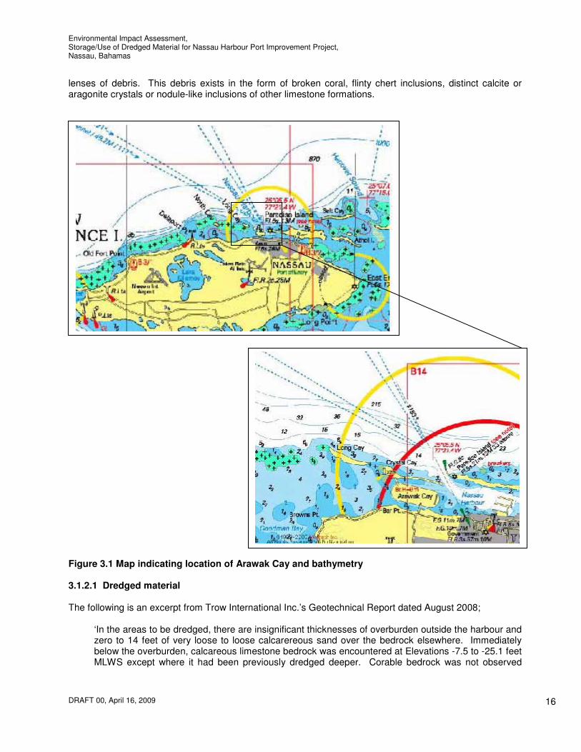
lenses of debris. This debris exists in the form of broken coral, flinty chert inclusions, distinct calcite or aragonite crystals or nodule-like inclusions of other limestone formations.
Figure 3.1 Map indicating location of Arawak Cay and bathymetry 3.1.2.1 Dredged material The following is an excerpt from Trow International Inc.’s Geotechnical Report dated August 2008;
‘In the areas to be dredged, there are insignificant thicknesses of overburden outside the harbour and zero to 14 feet of very loose to loose calcarereous sand over the bedrock elsewhere. Immediately below the overburden, calcareous limestone bedrock was encountered at Elevations -7.5 to -25.1 feet MLWS except where it had been previously dredged deeper. Corable bedrock was not observed
Environmental Impact Assessment, Storage/Use of Dredged Material for Nassau Harbour Port Improvement Project, Nassau, Bahamas
DRAFT 00, April 16, 2009
17
above the proposed dredge grades in six boreholes and it was encountered at Els. -12.0 to -24.0 feet in the other 10 boreholes.’
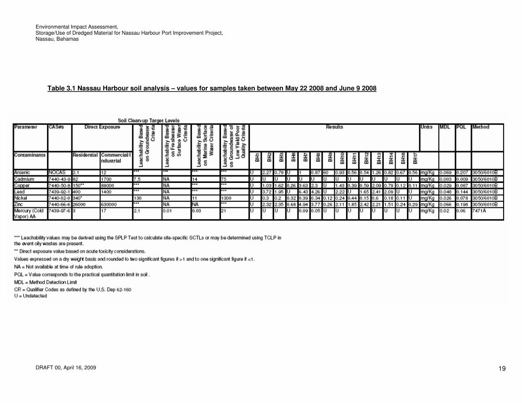
Therefore the majority of the dredged material will be calcareous sand and limestone bedrock. Drilling and soil sampling for metal analysis for the material to be dredged was carried out under the direction of Trow International Inc. between May 22 and June 9, 2008. Several metals were measured including arsenic, copper, cadmium, lead, mercury, zinc, and nickel. The soil analysis results are summarised in Table 3.1. Cadmium was not detected in any of the sediment samples. The majority of metals found in the sediments were below sediment quality guidelines found in literature. The mercury level at one borehole exceeds the USEPA criteria value however the area of heightened mercury content is restricted to a relatively small area. It is believed that this is a result of the build up of effluent from the West Bay Street Jetty Drain over many years when there may have been an industrial effluent that contained mercury.
3.1.2.2 Arawak Cay subsurface conditions The location of the extension and of the boreholes drilled to investigate the geotechnical conditions at it are shown in Figure 2.1 The surficial soil stratum is grey fine to coarse grained calcareous sand which contains shell fragments and is 4 to 6 feet thick. Calcareous limestone bedrock underlies the sand and extends to the bottom of the boreholes (ELs. -40.8 to 65.2 feet). In the eastern portions of the extension, the upper levels of the calcareous limestone are equivalent to loose sand to between Els. -16 to -18 feet. Below these levels in the westerly portion of the extension, it is equivalent to a compact to very dense sand down to Els. -16 to -19 feet. Below these levels, the bedrock was corable and the upper 10 to 21 feet is weak to very weak calcareous limestones with occasional medium strong zones. The unconfined compressive strength of intact cores from this layer range from 16 to 330 tsf. Below Els. -27 to -40 feet the bedrock is very weak to weak with extremely weak zones, which sometimes predominate. This rock extends to below the bottom of the boreholes on the south side of the extension. On the north side, it is underlain by weak to medium strong bedrock at Els. -51 to -57 feet. The calcareous limestone bedrock for 10 to 21 feet below Els. -17 to -21 feet contains occasional zones with unconfined compressive strengths of up to 330 tsf (4,500 psf), although it is generally much weaker.
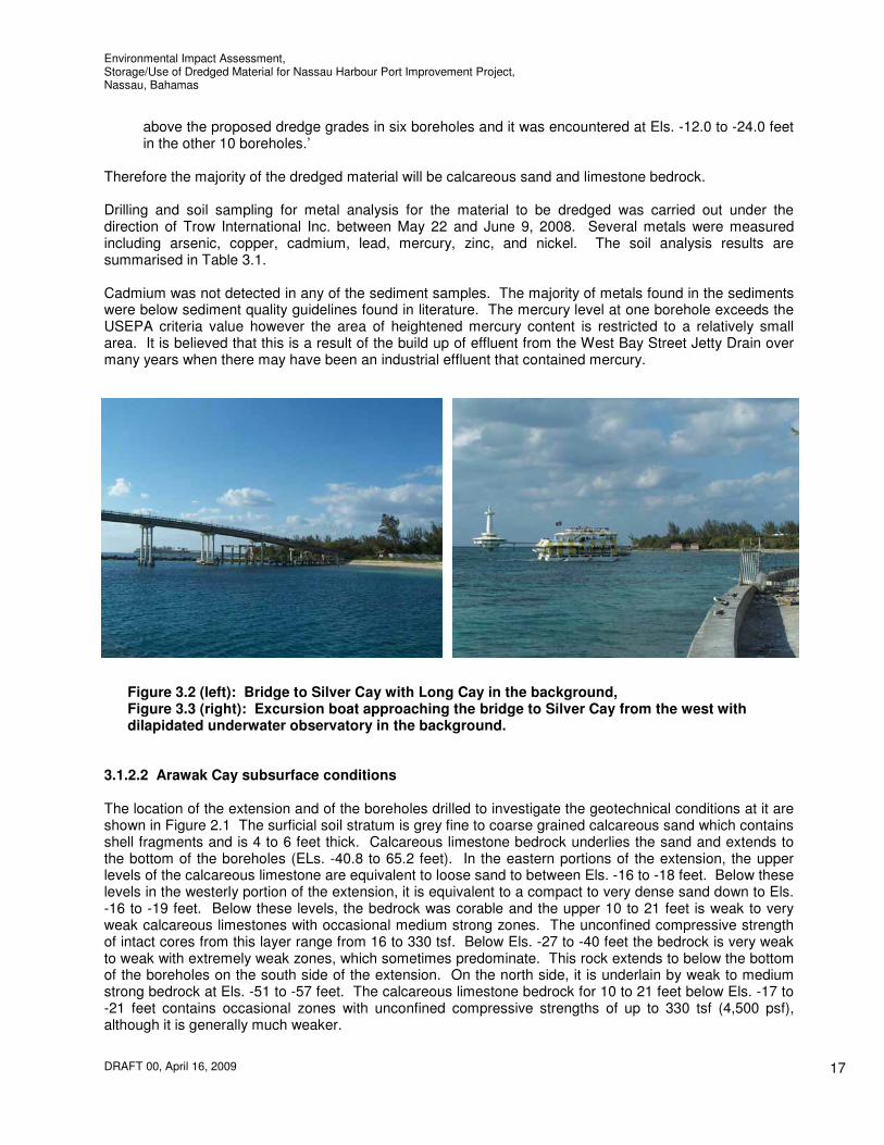
Figure 3.2 (left): Bridge to Silver Cay with Long Cay in the background, Figure 3.3 (right): Excursion boat approaching the bridge to Silver Cay from the west with dilapidated underwater observatory in the background.

Environmental Impact Assessment, Storage/Use of Dredged Material for Nassau Harbour Port Improvement Project, Nassau, Bahamas
DRAFT 00, April 16, 2009
18
3.1.3 Climate The Bahamas has a tropical maritime climate, which makes for generally year-round good weather. The Bahamas does not experience extremes of temperatures. There are two seasons: summer which is from May through September and winter which is from October through April. In centrally situated New Providence, winter temperatures seldom fall much below 60F degrees and usually reach about 75F degrees in the day. In summer, temperatures usually fall to 78F degrees or less at night and seldom rise above 90F degrees during the day. Relative humidity is fairly high averaging 65% yearly. The rainy season last from May thru October with most of the precipitation occurring during brief summer showers. The hurricane season spans from the 1
st June through to 30
th November when the islands may occasionally be
interrupted by the threat or presence of a tropical storm or hurricane. 3.1.4 Wind The wind conditions for the Caribbean Islands are dominated by trade winds which blow across the southern part of the north Atlantic Ocean (south of the Azores high pressure area). These winds approach with great constancy, primarily from the northeast and southeast directions. Some seasonal changes occur within this pattern, as a result of the relative position of the sun and the earth’s surface. In general, these seasonal changes in the annual wind regime may be described as follows: a. December to February: Winds are primarily from the NE to ENE. b. March to May: Winds are mainly from the east. c. June to August: Winds are primarily from the E to ESE. d. September to November: Winds are mainly from the E to SE. Wind speeds are influenced by the location of the Inter-tropical Convergence Zone, or ITCZ. The ITCZ is formed as a result of the convergence of north-east and south-east winds in a belt around the equator. This belt migrates north and south of the equator, in tandem with the suns motion. Since the ITCZ is characterised by wind uplift (as a result of convergence), surface wind speeds tend to be low in the vicinity of this feature. The ITCZ is closest to the Caribbean Islands between June and November. These months, therefore, have the lowest average wind speeds, compared with the rest of the year. Specific to the area of Arawak Cay, based upon local knowledge and observations prevailing winds at the site occur from the easterly trade winds. Mean wind speeds in Nassau are typically 8.1 mph (7 knots) with maximum winds speeds averaging 9.3mph (8 knots) for March. Maximum wind velocities are experienced during hurricanes which are further discussed below. 3.1.5 Storms Arawak Cay is located within the Atlantic Tropical Cyclone basin. The number of storms per year is variable in both the short and long term. Table 3.2 shows the number of storms per year passing within 200 miles of Nassau Harbour. The average number of storms is 0.82 storms per year (based on the data from 1900 to present). Storm surge occurs due to the onshore movement of water from onshore wind, and from the rise in the mean sea level as a result of low pressures in the centre of a storm. In Nassau, storm surge is typically related to the passing of a tropical storm or hurricane. Storms near Nassau (deepwater) have had a characteristic wave height of as much as 10.5 m. This is approximately equal to the significant wave height (average of the highest one-third of the waves) in deep water. These storms or hurricanes usually bring the extreme wind conditions with winds as great as a category 5 hurricane (135 knots/155.4 mph/250.0 km/h) having been measured in the Bahamas in the past (such as the hurricanes named ‘the Bahamas’ and ‘Fort Lauderdale’ in 1932 and 1947 respectively).
Environmental Impact Assessment, Storage/Use of Dredged Material for Nassau Harbour Port Improvement Project, Nassau, Bahamas
DRAFT 00, April 16, 2009
19
Table 3.1 Nassau Harbour soil analysis – values for samples taken between May 22 2008 and June 9 2008

Environmental Impact Assessment, Storage/Use of Dredged Material for Nassau Harbour Port Improvement Project, Nassau, Bahamas
DRAFT 00, April 16, 2009
20
Table 3.2 Number of Tropical Storms and Hurricanes passing within 200 miles of Arawak Cay
Year
Number of Storms
1980 1981 1982 1983 1984 1985 1986 1987 1988 1989 1990 1991 1992 1993 1994 1995 1996 1997 1998 1999 2000 2001 2002 2003 2004 2005 2006 2007
0 4 0 1 2 5 0 1 2 1 1 2 1 0 1 2 3 0 4 3 0 1 0 0 3 4 1 1
3.1.6 Waves 3.1.6.1 Offshore Deep-water Waves From wave data from the Bahamas grid between 1983 and 2008 it is clear that for conditions in water approximately 1500 feet deep north of Arawak Cay the majority of waves are from the NNE through the NE. Waves are usually below 3 feet in height however waves as high as 14 feet have been recorded such as during the storm during which the east breakwater to Nassau Harbour was damaged. These maximum wave conditions also generally occur from the NNE or the NNW due to a longer fetch. 3.1.6.2 Inshore Coastal Waves Given the extremely well protected nature of Arawak Cay, the prevailing wave and swell wave climate does not result in waves greater than 40 to 60% of the offshore wave height west of Arawak Cay due to the shallow nature of the areas between Silver Cay, Long Cay and North Cay. There are three manners by which waves approach the area west of Arawak Cay and Saunders Beach. These are either locally generated waves from westerly winds in the shallows inside Long Cay or offshore waves entering from between Silver Cay and Long Cay or from the west side of Long Cay. Waves from offshore are the most significant as waves generated locally in shallow water have shorter
Environmental Impact Assessment, Storage/Use of Dredged Material for Nassau Harbour Port Improvement Project, Nassau, Bahamas
DRAFT 00, April 16, 2009
21
fetches and are therefore smaller. It is likely that generally, the wave energy entering through the gap between Silver Cay and Long Cay is greater than the energy approaching from the west of Long Cay, the resultant wave direction close to Saunders Beach is just east of north. 3.1.7 Tides The tides at Arawak Cay are semi-diurnal (12.42 hour periods). The mean tide range is 2.6 feet, and the spring tide range is 3.1 feet. At Arawak Cay, the flood currents move from west to east and the ebb current vice versa. 3.1.8 Currents 3.1.8.1 Offshore Deep-water Currents The deep-water currents offshore of the northwestern coastline of The Bahamas are influenced by the beginning of the Gulf Stream System. The Florida current can be considered the "official" beginning of the Gulf Stream System. The Florida Current receives its water from two main sources, the Loop Current and the Antilles Current. The Loop current is the most significant of these sources and can be considered the upstream extension of the Gulf Stream System. The Florida Current generally causes currents between Florida and the Bahamas to be in a northerly direction and through the Bahamas in a north westerly direction. 3.1.8.2 Inshore Coastal Currents Current measurements were undertaken on October 28
th and 29
th 2008 in order to gain insight to the
typical tidal currents as well as the effect of wind and waves on currents around Arawak Cay. Conditions on the 28
th involved strong northwesterly winds, while the 29
th was much calmer and more
typical of conditions in the area. The wind conditions on the 28th were unusual, in that winds over 33
ft/s from the NW quadrant occur only about one percent of the time. Tides during sampling were mid-range in terms of magnitude and are approximately equal to the mean tides at the site. Currents were measured with a RDI Rio Grande 600 kHz Acoustic Doppler Current Profiler (ADCP) which uses acoustic pulses from four beams on the instrument to measure the current velocity through the water column. Most of the tidal flow enters Nassau Harbour through the harbour mouth, between the east and west breakwaters. A relatively small amount of flow passes through the north and south channels adjacent to Arawak Cay. The total volume of water that passes through the harbour during an ambient ebb tide is approximately 28,000 cubic feet per second, 27,000 cubic feet per second of which passes through the harbour channel between the east and west breakwater, 900 cubic feet per second of which passes through the north channel and 350 cubic feet per second of which passes through the south channel. Flows are very similar for the flood tide. The velocities of the flow in the wider parts of the north channel is 0.07 ft/s which increase to 0.3 ft/s in the narrower areas and 1.5 ft/s under rare high wind conditions. Evidence from the bathymetry in this area suggests that under storm conditions the flows and current velocities are much higher in the narrow area and some scour occurs. Current velocities in the south channel were also very weak, at about 0.1 ft/s. In the shallower water of this channel wind may be the dominant factor in determining the current velocities. The ambient ebb tide at Arawak Cay and Nassau Harbour drives water from the east to the west. Throughout most of the area current velocities during the ebb and flood tides are very similar. Flows from the east through the harbour area appear to be marginally stronger than the opposing flood tide most probably due to the prevailing east wind. The peak ebb tidal flow across the main harbour has a flow velocity of 0.65 ft/s.

Environmental Impact Assessment, Storage/Use of Dredged Material for Nassau Harbour Port Improvement Project, Nassau, Bahamas
DRAFT 00, April 16, 2009
22
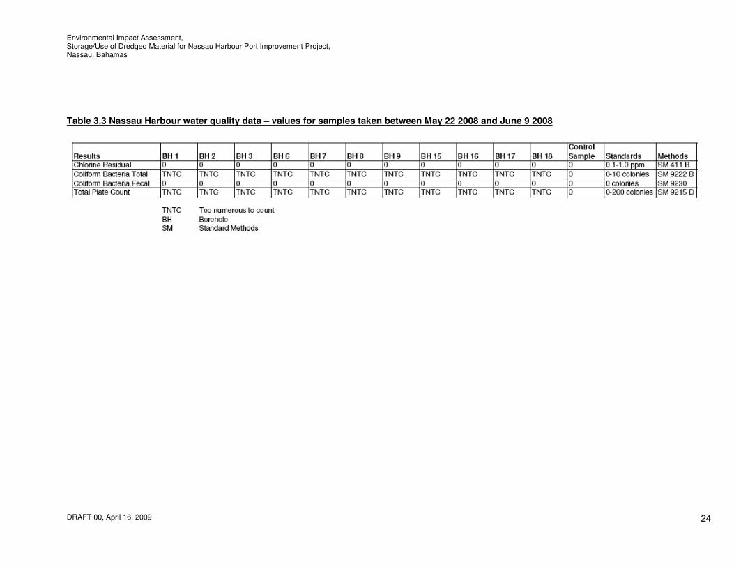
Longshore currents are dependant on the wave direction outside the harbour. Corresponding to a storm with a 9ft wave height, 8s period and NW direction (though rare this is the worse case), longshore currents are towards the east along the Western Esplanade beaches less than 0.2 knots. 3.1.9 Surface drainage Various drains empty into the sea near Arawak Cay one of which is located at the east end of Saunders Beach. These are contaminated with various wastes, including sediments, from the surrounding watersheds and urban areas. The extent to which these drains impact the water quality in the area is not fully understood. A study is currently being carried out for the 2008 WSSS Practicum/UEP Field Project ‘Integrated Assessment of Impacts of Stormwater in Coastal Zone of Nassau, New Providence, The Bahamas’. It is understood that it is the Governments intention to improve stormwater drainage on the island and that various projects are underway to do so. Arawak Cay itself drains naturally into the sea by way of surface runoff and through flow. 3.1.10 Marine water quality The values of the data generated by the water quality monitoring exercises conducted in Nassau Harbour between May 22
nd and June 9
th are presented in Table 3.3. Data for the following critical
pollution indicators are tabulated and discussed for the purposes of this document;
a) Residual Chlorine b) Total Coliforms c) Fecal Coliforms d) Total Plate Count
a) Residual Chlorine Residual chlorine is chlorine that is present in the form of hypochlorous acid, hypochlorite ions or as dissolved elemental chlorine. Chlorine is extremely toxic to aquatic life in both freshwater and saltwater. Thus, every discharger that uses chlorine has the potential to cause acute toxicity. Although a chlorination-dechlorination process can be used and maintained, it can be incomplete, leaving total residual chlorine (TRC). No residual chlorine was detected in the samples taken suggesting that the level of treated water is minimal or that the process is complete. b) Total Coliforms The elevated total coliforms that are present in the source water indicate that the general quality of the water is poor and that it is likely that the water is fecally contaminated however this is not the case. Refer to fecal coliform results discussed below. c) Fecal Coliforms The lack of presence of fecal coliform bacteria indicates that the water has not been contaminated with the fecal material of man or other animals. Fecal coliform bacteria can enter waters through direct discharge of waste from mammals and birds, from agricultural and storm runoff, and from untreated human sewage. Large quantities of fecal coliform bacteria in water may indicate a higher risk of pathogens being present in the water.
Untreated organic matter that contains fecal coliform can be harmful to the environment. Aerobic decomposition of this material can reduce dissolved oxygen levels if discharged into waterways. This may reduce the oxygen level enough to kill fish and other aquatic life. Reduction of fecal coliform in wastewater may require the use of chlorine and other disinfectant chemicals. Such materials may kill the fecal coliform and disease bacteria. They also kill bacteria essential to the proper balance of the aquatic environment, endangering the survival of species dependent on those bacteria. So, higher levels of fecal coliform require higher levels of chlorine, threatening those aquatic organisms.

Environmental Impact Assessment, Storage/Use of Dredged Material for Nassau Harbour Port Improvement Project, Nassau, Bahamas
DRAFT 00, April 16, 2009
23
The current EPA recommendations for fecal coliform levels in body-contact recreation is fewer than 100 colonies/100 ml; for fishing and boating, fewer than 1000 colonies/100 ml; and for domestic water supply, for treatment, fewer than 2000 colonies/100 ml. The drinking water standard is less than 1 colony/ 100 ml. d) Total Plate Count Total Plate Count is a bacterial enumeration procedure used to estimate bacterial density in an environmental sample. This test does not differentiate between the many different types of bacteria and is thought of as giving index to the general "housekeeping" practices. A "high" count indicates that some type of contamination is present and is undesirable. In summary, this analysis shows that the water samples have elevated Total Plate Counts and Total Coliform Counts. This condition is not unusual for water that is of salt water origin. It should also be noted that the fecal coliform was undetected. Whilst the tests carried out are very limited, in general these indicate that the water quality is in good condition. Observations were made with regard to turbidity levels at Arawak Cay during good weather and poor weather conditions and samples taken during poor weather conditions. During good weather conditions the turbidity of the area was 0 NTU, the water being extremely clear. It is considered appropriate however to use a background turbidity level that reflects poor weather conditions. The site was visited on five separate poor weather condition days and samples taken. The worst turbidity level found on these days was 7 NTU. It is therefore considered appropriate to use a level of 7 NTU as the background turbidity level for future monitoring purposes.
Environmental Impact Assessment, Storage/Use of Dredged Material for Nassau Harbour Port Improvement Project, Nassau, Bahamas
DRAFT 00, April 16, 2009
24
Table 3.3 Nassau Harbour water quality data – values for samples taken between May 22 2008 and June 9 2008

Environmental Impact Assessment, Storage/Use of Dredged Material for Nassau Harbour Port Improvement Project, Nassau, Bahamas
DRAFT 00, April 16, 2009
25
3.2 Biological Environment 3.2.1 Terrestrial ecology The description of terrestrial biological resources characterised within this document focuses on the vegetation communities, wildlife, threatened and protected flora and fauna, and important habitat for local and migratory species. The terrestrial environment surrounding Arawak Cay is coastal. The coastal zone dominates small island ecology. Because of the effects of currents, waves, tidal changes, storms, and hurricanes, the coastal zone is a dynamic environment. The coastal zone includes many diverse and interconnected ecosystems and communities so that any impact on one ecosystem or community can directly affect all others that are connected to it through the life histories of species that travel between them (B.E.S.T., 2002). The coastal zone provides critical habitats and resources for many species, such as seabirds, and marine mammals. Additionally, coastal zones also provide people with benefits, which include hurricane buffer zones, tourist attractions, educational opportunities, and living resources (B.E.S.T., 2002). Arawak Cay itself is completely artificial in nature with an abrupt sea wall shoreline. The vegetation on Arawak Cay has grown since 1989 when Nassau Harbour was dredged and the material stockpiled on Arawak Cay. With regard to the vegetation found there were a vast number of invasive species found on the island, most notably Australian Pine (Casuarina equisetifolia), Hawaiian sea grape (Scaevola sericea), Jumbey (Leucaena glauca), Carpet Daisy or Wedelia (Wedelia trilobata) and more sparse the Tropical Almond (Terminalia catappa) and Woman's Tongue (Albizia lebbeck). There were a couple sparse non-native plants namely the Papaya (Carica papaya) and the non-native Poui Tree (Tabebuia rosea). Of the native variety were Morning Glory – Ipomoea purpurea and Saav Bush also known as Salve bush - Solanum erianthum which were somewhat plentiful in areas and Sea grape -
Coccoloba uvifera which was very sparse. An area of button wood was also located on the north east side of the west bridge.
Figure 3.4: Vegetation on Arawak Cay where the stockpiling of material is proposed.
The Australian pine tree (Casuarina equisetifolia), is the most common vegetation found on Arawak Cay. It is destabilising the coastline by causing erosion of the soil and taking over the habitats of important endemic species. Australian pine, also known as casuarina, is a deciduous tree with a soft, wispy, pine-like appearance, which grows 5-10 feet per year to a maximum of 100 feet or more. Once established, it radically alters the temperature, light, and soil chemistry of habitats, and inhibits the growth of native vegetation, vital for coastal ecosystems. Also, unlike native shrubbery, the thick, shallow roots of Australian pine make it much more susceptible to high winds.
Environmental Impact Assessment, Storage/Use of Dredged Material for Nassau Harbour Port Improvement Project, Nassau, Bahamas
DRAFT 00, April 16, 2009
26
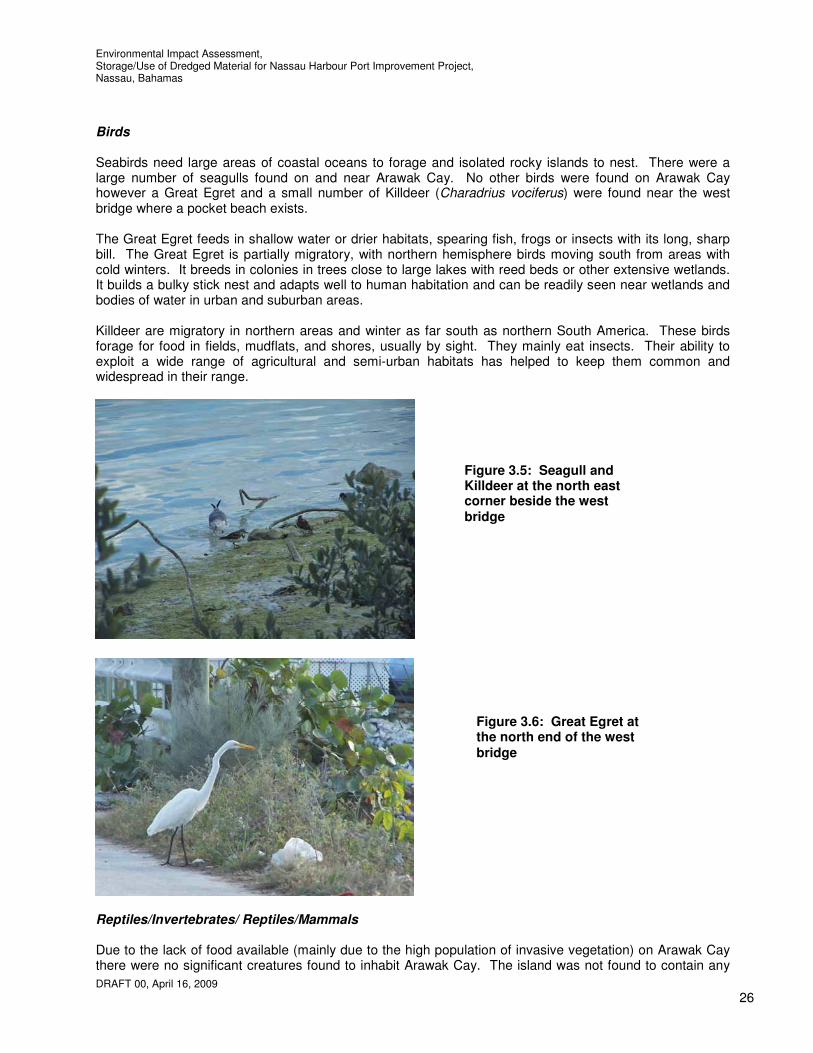
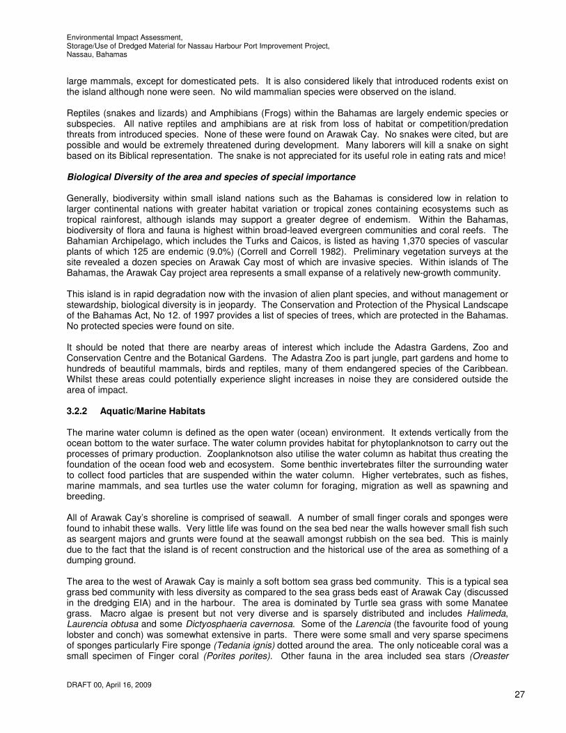
Birds Seabirds need large areas of coastal oceans to forage and isolated rocky islands to nest. There were a large number of seagulls found on and near Arawak Cay. No other birds were found on Arawak Cay however a Great Egret and a small number of Killdeer (Charadrius vociferus) were found near the west bridge where a pocket beach exists. The Great Egret feeds in shallow water or drier habitats, spearing fish, frogs or insects with its long, sharp bill. The Great Egret is partially migratory, with northern hemisphere birds moving south from areas with cold winters. It breeds in colonies in trees close to large lakes with reed beds or other extensive wetlands. It builds a bulky stick nest and adapts well to human habitation and can be readily seen near wetlands and bodies of water in urban and suburban areas. Killdeer are migratory in northern areas and winter as far south as northern South America. These birds forage for food in fields, mudflats, and shores, usually by sight. They mainly eat insects. Their ability to exploit a wide range of agricultural and semi-urban habitats has helped to keep them common and widespread in their range.
Reptiles/Invertebrates/ Reptiles/Mammals Due to the lack of food available (mainly due to the high population of invasive vegetation) on Arawak Cay there were no significant creatures found to inhabit Arawak Cay. The island was not found to contain any
Figure 3.5: Seagull and Killdeer at the north east corner beside the west bridge
Figure 3.6: Great Egret at the north end of the west bridge
Environmental Impact Assessment, Storage/Use of Dredged Material for Nassau Harbour Port Improvement Project, Nassau, Bahamas
DRAFT 00, April 16, 2009
27
large mammals, except for domesticated pets. It is also considered likely that introduced rodents exist on the island although none were seen. No wild mammalian species were observed on the island. Reptiles (snakes and lizards) and Amphibians (Frogs) within the Bahamas are largely endemic species or subspecies. All native reptiles and amphibians are at risk from loss of habitat or competition/predation threats from introduced species. None of these were found on Arawak Cay. No snakes were cited, but are possible and would be extremely threatened during development. Many laborers will kill a snake on sight based on its Biblical representation. The snake is not appreciated for its useful role in eating rats and mice! Biological Diversity of the area and species of special importance Generally, biodiversity within small island nations such as the Bahamas is considered low in relation to larger continental nations with greater habitat variation or tropical zones containing ecosystems such as tropical rainforest, although islands may support a greater degree of endemism. Within the Bahamas, biodiversity of flora and fauna is highest within broad-leaved evergreen communities and coral reefs. The Bahamian Archipelago, which includes the Turks and Caicos, is listed as having 1,370 species of vascular plants of which 125 are endemic (9.0%) (Correll and Correll 1982). Preliminary vegetation surveys at the site revealed a dozen species on Arawak Cay most of which are invasive species. Within islands of The Bahamas, the Arawak Cay project area represents a small expanse of a relatively new-growth community. This island is in rapid degradation now with the invasion of alien plant species, and without management or stewardship, biological diversity is in jeopardy. The Conservation and Protection of the Physical Landscape of the Bahamas Act, No 12. of 1997 provides a list of species of trees, which are protected in the Bahamas. No protected species were found on site. It should be noted that there are nearby areas of interest which include the Adastra Gardens, Zoo and Conservation Centre and the Botanical Gardens. The Adastra Zoo is part jungle, part gardens and home to hundreds of beautiful mammals, birds and reptiles, many of them endangered species of the Caribbean. Whilst these areas could potentially experience slight increases in noise they are considered outside the area of impact. 3.2.2 Aquatic/Marine Habitats The marine water column is defined as the open water (ocean) environment. It extends vertically from the ocean bottom to the water surface. The water column provides habitat for phytoplanknotson to carry out the processes of primary production. Zooplanknotson also utilise the water column as habitat thus creating the foundation of the ocean food web and ecosystem. Some benthic invertebrates filter the surrounding water to collect food particles that are suspended within the water column. Higher vertebrates, such as fishes, marine mammals, and sea turtles use the water column for foraging, migration as well as spawning and breeding. All of Arawak Cay’s shoreline is comprised of seawall. A number of small finger corals and sponges were found to inhabit these walls. Very little life was found on the sea bed near the walls however small fish such as seargent majors and grunts were found at the seawall amongst rubbish on the sea bed. This is mainly due to the fact that the island is of recent construction and the historical use of the area as something of a dumping ground. The area to the west of Arawak Cay is mainly a soft bottom sea grass bed community. This is a typical sea grass bed community with less diversity as compared to the sea grass beds east of Arawak Cay (discussed in the dredging EIA) and in the harbour. The area is dominated by Turtle sea grass with some Manatee grass. Macro algae is present but not very diverse and is sparsely distributed and includes Halimeda, Laurencia obtusa and some Dictyosphaeria cavernosa. Some of the Larencia (the favourite food of young lobster and conch) was somewhat extensive in parts. There were some small and very sparse specimens of sponges particularly Fire sponge (Tedania ignis) dotted around the area. The only noticeable coral was a small specimen of Finger coral (Porites porites). Other fauna in the area included sea stars (Oreaster

Environmental Impact Assessment, Storage/Use of Dredged Material for Nassau Harbour Port Improvement Project, Nassau, Bahamas
DRAFT 00, April 16, 2009
28
reticulates), sea urchins (Tripneustes ventricosus) and small areas covered with the Stocky Cerith (Cerithium litteratum). Overall this area was not found to be very biologically diverse.
Further north towards the reef ridge between Silver Cay and Long Cay the sea floor became dominated by brown macro algae and is partially hard bottom. This area experiences greater current and there is evidence of wave damage from the scatter of hard coral remains. Close to the ridge the biological diversity increases. Many hard corals, sponges and a few gorgonians are found in this area. They are generally small but there is a large variety and most appear to be in good health. Stony corals include different brain corals (Diploria sp), Star corals (Siderastrea, Montastrea sp), Fire corals (Millepora sp), and the Agoricia sp. which dominate the diversity. Interestingly, despite the perfect conditions, no Acropora sp. was found in the area. The sponges are dominated by the encrusting or low growing varieties, likely due to the heavy tidal current in the area. Sponges include Ircinia strombilina, I. felix and Agelas wiedenmyeri. The fish on the reef ridge were small but very diverse. There were many wrasses, butterfly fish and porgys and some barracuda, juvenile parrot and hogfish were spotted. Sea urchins (Diadema antillarum) were abundant in spots. Over all the ridge reef to the north and west of Arawak Cay are very biologically diverse, most probably benefited by the good flow of water from offshore. 3.2.3 Protected areas Established by an Act of Parliament in 1959, the Bahamas National Trust is mandated with the conservation of natural and historic resources of The Bahamas. This responsibility is achieved primarily through in-situ protection. These protected areas are outside the influence of this project.
Figure 3.7: Small fish amongst waste on the sea bed near the west edge of Arawak Cay.
Figure 3.8: Small finger corals and sponges on the west face of Arawak Cay seawall

Environmental Impact Assessment, Storage/Use of Dredged Material for Nassau Harbour Port Improvement Project, Nassau, Bahamas
DRAFT 00, April 16, 2009
29
Figure 3.9 (left): Sea grass beds east of Arawak Cay Figure 3.10 (top): Brown macro algal and more hard bottom south of the coral ridge between Silver Cay and Long Cay
Figure 3.11: Coral located between Silver Cay and Long Cay

Environmental Impact Assessment, Storage/Use of Dredged Material for Nassau Harbour Port Improvement Project, Nassau, Bahamas
DRAFT 00, April 16, 2009
30
Figure 3.12; Various corals located in-between Silver Cay and Arawak Cay 3.3 Socio-economic and Cultural Environment 3.3.1 Demography Nassau is the capital, largest city, and commercial centre of the Commonwealth of the Bahamas. The city has a population of 210,832 (2000 census), nearly 70 percent of the entire population of the Bahamas (303,611) with an annual growth rate of 1.41% (1997 est.). Each year, visitors and overnight guests bring in excess of 1.5 billion dollars to the local economy. From January to October 2007, there were 2.3 million foreign visitors to New Providence. It is estimated that there are 3.6 million visitors to the Bahamas each year.

Environmental Impact Assessment, Storage/Use of Dredged Material for Nassau Harbour Port Improvement Project, Nassau, Bahamas
DRAFT 00, April 16, 2009
31
3.3.2 Land use Bahamian soils are thin, coarse-textured and fragile, and quickly become exhausted. Various attempts at commercial agriculture have been tried, and some have had some success. Land use has changed dramatically on New Providence over the past thirty years with the building of several large resort hotels, and large tracts of land have been cleared for housing, business complexes and roads. Arawak Cay was artifically built from dredged material when the harbour was dredged in 1966. It was later used to stockpile dredged material during the dredging that was carried out in 1989. The material stockpiled at that time was removed over a number of years on Government civil works projects. Since that time, large sections of Arawak Cay have become occupied by commercial operations, the largest being the container handling operation at the east end of Arawak Cay. Other operations include the water reservoirs, aggregate storage, asphalt plant and contractors storage yard. The land on Arawak Cay that will be directly impacted by the proposed work (i.e. stockpiling areas and the west end of the island onto which the extension is to be built) is currently unused land which is mainly covered by vegetation. It is understood that there is little infrastructure in the form of utilities on Arawak Cay other than that to supply the existing infrastructure on Arawak Cay and to serve Silver Cay. Utility lines on telegraph poles do run the length (east-west)of Arawak Cay close to the middle of the island as well as in the opposite direction (north-south) from the west bridge. There are two bridges between Arawak Cay and New Providence. The west bridge is a multispan bridge spanning a total of 90 feet. The east bridge is a single span bridge spanning 22 feet. At present the west bridge is closed to traffic although it is often used as a parking area for vehicles. The east bridge is in operation and receives a steady flow of heavy goods traffic during the day. These bridges both have restricted clearance beneath them such that it is possible for small skiffs to pass beneath them. Another interesting fact associated with the construction of Arawak Cay is the location of the Queen's Warehouse, located on the east end of Arawak Cay. We believe that original construction drawings identify this structure as the Passenger Hall. Based on anecdotal information, this building, intended to handle passengers at the upper level and baggage and some cargo on the lower level, was supposed to be located at Prince George Wharf. For whatever reason, when the prefabricated steel structure components arrived by ship in Nassau, it was discovered that the building was too wide to be located on the Centre Pier as proposed. This led to the decision being made to erect it on the east end of Arawak Cay for use as the Queen's Warehouse for storage of bonded cargo. In this location it was inaccessible to ships because of draft restrictions and bonded cargo had to be trucked to this location. This eventually proved to be impractical. Efforts were made to use this building for other purposes; however, it has eventually fallen into a state of gross disrepair. Arawak Cay is located close to the harbour and downtown area which is used for commerce, recreation, housing, tourism, administration and transport, and includes a cruise ship pier, marinas, restaurants, various docks, residences and bathing beaches. Arawak Cay has a number of areas of interest to tourists as well as residents in close proximity including Fort Charlotte, the Hanes Oval Cricket Pitch, Adastra Gardens, Botanical Gardens, Saunders beach and Western Esplanade beaches and Heritage Village. Of all of these areas Heritage Village or the Fish Fry, is a popular location for locals and visitors alike is located just north of Fort Charlotte and Hanes Oval Cricket Pitch on west Bay Street. The site has a police station, a story telling porch, and a “rock-oven” commonly used on the Family Islands for baking. There is a village green where festivals, cultural events and concerts are held. A Junkanoo rush-out is held during the month June, the purpose of which is to give visitors who are unable to attend during the Christmas and New Year’s celebrations a taste of what it is like. Heritage Village is also the home of a lively, culturally rich seafood vendor village with a number of Bahamian clap-board vernacular style homes that house a colorful mix of eateries. Coral Island Bahamas was developed by Coral World International. The park was built on a the private island of Silver Cay and opened to the public in 1987 and immediately became the top tourist attraction in Nassau. The Coral Island Marine Park incorporated a Marine Museum, Underwater Observatory, Stingray,

Environmental Impact Assessment, Storage/Use of Dredged Material for Nassau Harbour Port Improvement Project, Nassau, Bahamas
DRAFT 00, April 16, 2009
32
Shark and Turtle Pools, Touch Pool, Snorkel Trail, and a unique, secluded Villa Hotel. In 1995, in accordance with Coral World International’s global strategy, the park was sold to the owners of the Marriot Nassau Beach Hotel. Coral Island Bahamas then operated under the title "Silver Cay". It is understood that Silver Cay has since changed ownership and is now dilapidated and available for sale. 3.3.3 Education Education in the Bahamas is compulsory between the ages of 5 and 16. As of 2003, the school attendance rate was 92% and the literacy rate was 95.5%. The government fully operates 158 of the 210 primary and secondary schools in The Bahamas. The other 52 schools are privately operated. Enrollment for state primary and secondary schools is 50,332, with more than 16,000 students attending private schools. Some public schools lack basic educational materials and are overcrowded. The College of The Bahamas, established in Nassau in 1974, provides programs leading to bachelors and associates degrees. Several non-Bahamian colleges also offer higher education programs in The Bahamas. 3.3.4 Employment About half the working population is employed in the tourist trade assisting the 3.6 million visitors who arrive in the Bahamas each year. The other major employers are in the financial and business services. The storage/use of dredged material from Nassau Harbour will provide a number of employment opportunities for Bahamians during construction. A large number of locals are expected to be involved in the sheet piling operations and site clearance for instance. The direct employment content of the project after construction is negligible. 3.3.5 Economic Activities The Bahamas is one of the wealthiest Caribbean countries with an economy heavily dependent on tourism and offshore banking. Tourism together with tourism-driven construction and manufacturing accounts for approximately 60% of GDP and directly or indirectly employs half of the archipelago's labor force. Steady growth in tourism receipts and a boom in construction of new hotels, resorts, and residences had led to solid GDP growth in recent years, but tourist arrivals have been on the decline since 2006. Financial services constitute the second-most important sector of the Bahamian economy and, when combined with business services, account for about 36% of GDP. Manufacturing and agriculture combined contribute approximately a tenth of GDP and show little growth, despite government incentives aimed at those sectors. Agriculture and fisheries industry together account for 5% of GDP. The Bahamas exports lobster and some fish but does not raise these items commercially. There is no large-scale agriculture, and most agricultural products are consumed domestically. The Bahamas imports more than $250 million in foodstuffs per year, representing about 80% of its food consumption. The government aims to expand food production to reduce imports and generate foreign exchange. It actively seeks foreign investment aimed at increasing agricultural exports, particularly specialty food items. The government officially lists beef and pork production and processing, fruits and nuts, dairy production, winter vegetables, and Mari culture (shrimp farming) as the areas in which it wishes to encourage foreign investment. Overall growth prospects in the short run rest heavily on the fortunes of the tourism sector. Tourism, in turn, depends on growth in the US, the source of more than 80% of the visitors. 3.3.5.1 Tourism Tourism dominates the Bahamian economy. In 1999, 3.65 million people visited the islands, with 2.2 million of them arriving by cruise ship. Revenue from tourism made up 60 percent of the nation's GDP. The average tourist spent US$958 while vacationing in the Bahamas, and tourist spending overall amounted to US$1.5 billion. In 2000, there were about 81,700 people employed in the tourist industry. Most visitors are from the United States (83 percent in 1999). The largest resort in the island is the 2,340 room mega-resort

Environmental Impact Assessment, Storage/Use of Dredged Material for Nassau Harbour Port Improvement Project, Nassau, Bahamas
DRAFT 00, April 16, 2009
33
Atlantis, which is owned by Sun International. It employs 5,500 people and is the second largest employer in the nation after the government. All major cruise lines operate services to the Bahamas. To extend the stay of passengers, the government has enacted legislation that allows ships to open their casinos and stores only if they remain in port for more than 18 hours. 3.3.5.2 Commerce Nassau Harbour is the hub of commercial activity for much of the country. It is under the umbrella development of Nassau Harbour that the proposed dredging project will be contributory to anticipated economic benefits. 3.3.5.3 Shipping Shipping and port facilities constitute a major land use for Arawak Cay and Nassau Harbour and therefore shipping schedules need to be considered with respect to potential short-term dislocation from dredging works. There can be as many as twelve or more ship movements (arrivals and departures) in Nassau Harbour in a single day and a number of visiting yachts. At Arawak Cay barges regularly load and off-load on the north side and numerous recreational boats utilise the narrow channel between Arawak Cay and the west breakwater. Navigation through this channel is currently somewhat hindered due to the presence of a sunken vessel in the channel near the west end. Portions of this sunken vessel are very shallow and buoys have been attached in order to indicate the portion of the channel which can not be navigated. The Port Department has attempted to remove this obstacle more than once without success. 3.3.5.4 Fishing Fishing is important to the economy of Nassau, it is estimated that fishing contributes 1.5% to the nations GDP. There are an estimated 9,300 fishermen (Joint FAO/DOF 1995 Fisheries Census) and there is a ready market for fish, which is sold mainly in Nassau but also abroad. This industry is suffering from over fishing and declining yields. The commercial fishing industry of The Bahamas is based primarily on its shallow water banks, principally the Little Bahama Bank and the Great Bahama Bank. Other shallow water bank areas are also found adjacent to several of the southeastern islands. Results of the 1995 Fisheries Census indicated the Bahamian fishing fleet consists of over 4 000 fishing vessels ranging in size from 10 ft to 90ft of which 600 are over 20 ft. The smaller vessels are the actual fishing power of the fleet and in this regard in excess of 1,500 of them work in conjunction with the larger fishing vessels. There are five main categories of gear used for fishing. These include nets, hook & line, impaling gear (Hawaiian sling and spear), wire pots and wooden traps and casitas/condominiums and hooks. Sport fishing is a major tourist attraction for The Bahamas and not considered commercial. This is particularly true in the Family Islands where a significant percentage of stopover visitors arrive by boat. Besides tourists, sport fishing is also a popular activity for Bahamians. The main targeted species are Blue Marlin, White Marlin, Wahoo, Dolphin (mahi-mahi), Tunas and Bonefish. A number of fishermen use the sheltered area between Arawak Cay and New Providence to store their boats. Parts of Arawak Cay are also used for boat building. Fishermen often store their livestock at the seawalls at Arawak Cay as well as Potters Cay further east where they keep it in the water until sold to keep it fresh at nearby stalls and the Fish Fry. 3.3.5.5 Diving/Snorkeling
Environmental Impact Assessment, Storage/Use of Dredged Material for Nassau Harbour Port Improvement Project, Nassau, Bahamas
DRAFT 00, April 16, 2009
34
The following is an excerpt from the ‘Scuba Diving’ magazine;
‘Since the early days of scuba, New Providence and Grand Bahama have been on the A-list of dive destinations. Nothing compares to this island chain for sheer diversity, from outrageous walls to high-octane animal encounters. The Tongue of the Ocean, a deep oceanic trench that drops to 6,000 feet and extends to the south for more than 100 miles, wraps around the western side of New Providence, providing mile after mile of stunning wall dives. The island also offers easily accessible shallow reefs and an armada of wrecks on both its northern and southwestern sides’.
Whilst there are many diving locations around Nassau one diving location at which dive boats take divers occasionally is located on the north side of the east breakwater at the location of the damage to the breakwater. These boats anchor at this location where divers enter the water to visit and dive a nearby wreck and artificial reef at approximately 25-30 foot depth. Other dives are the ocean wall dives which are done along the edge of the Tongue-Of-The Ocean, approximately 7 or 8 miles north of Arawak Cay. Divers are usually limited to diving to a depth of 85 feet. Here different sea creatures can be seen on descent of this nearly vertical wall where there are large corals, sponges and a vast assortment of exotic fish. The nearest snorkeling tours visited on a regular basis are at the east end of Athol Island approximately 5 miles east of the proposed works. 3.3.6 Natural and technological hazard vulnerability Storm surge as a result of hurricanes, and storm waves are the major natural hazards affecting the Arawak Cay area. The dredging and storage of dredging material activities could be affected as they will be carried out during the hurricane season. There are no records of earthquake activity or tsunamis for the area. Technological hazards associated with the area include oil spills, fires, accidents, and polluted discharges from vessels.

Environmental Impact Assessment, Storage/Use of Dredged Material for Nassau Harbour Port Improvement Project, Nassau, Bahamas
DRAFT 00, April 16, 2009
35
Figure 3.13 Map of the Commonwealth of the Bahamas indicating the Tongue of the Ocean
4. ENVIRONMENTAL ORGANISATIONS, POLICY, LEGISLATION AND REGULATORY FRAMEWORK
The Commonwealth of the Bahamas does not have a national plan for land use or physical infrastructure development. Physical planning is therefore by default reliant on reactive forms of development control which has been a difficult planning tool to use successfully for rational land management. The Town Planning Act (1961) is the legislation providing the statutory basis for land use planning resources and has produced mixed success in outcomes. The 1988 Planning regulations prepared under Section 17 of this act provides the basis for land development, land use planning standards, zoning, design and signage guidelines. Application of these stipulations is the responsibility of the Town Planning Committee. The Conservation and Protection of the of the Physical Landscape of the Bahamas Act and Regulations 1997 refers to control of “any excavation for the purpose of work which would effect any part of the coastline of the Bahamas, the digging or removal of sand and beaches and sand dunes”. The current project is one deemed by the Government to be of public utility but nevertheless subject to environmental impact assessment. The Contractor and project staff will be responsible for complying with government legislation regarding opening of borrow pits and site development (including excavation, landfill operations and removal of protected trees) at all times. [Ref: The Conservation and Protection of the Physical Landscape of the Bahamas Act and Regulations 1997]. The Department of Physical Planning within the Ministry of Works and Utilities is responsible for approving applications for permits to carry out excavations or landfill operations, applications to quarry or mine and applications to harvest (or cut) a protected tree. Forms are submitted and permits given for a one year period under Section 7 of the 1997 Act. The Environmental Health Act (1987) makes provision for the prevention and control of pollution through The Department of Environmental Health. The Water and Sewerage Act (1976) established the Water and Sewerage Corporation for the grant and control of water rights, the protection of water resources, regulating the extraction,

Environmental Impact Assessment, Storage/Use of Dredged Material for Nassau Harbour Port Improvement Project, Nassau, Bahamas
DRAFT 00, April 16, 2009
36
use and supply of water and the control of sewage. The Contractor will be required to adhere to existing and new government regulations of the Department of Environmental Health, including all statutory licensing and permitting requirements with respect to use of waste landfills and new occupational health legislation. National Laws and Regulations
The project will be designed, constructed, operated, and maintained in accordance with applicable Bahamian environmental laws and regulation, including the following;
The Environmental Health Act The Conservation and Protection of the Physical Environment of the Bahamas Act The Antiquities, Monuments, and Museums Act The Public Works Act The Wild Birds and Plants Protection Acts The Bahamas National Trust Act The Fisheries Resources Act The Coast Protection Act The Water and Sewerage Act The Bahamas National Wetlands Policy 2007; and The National Invasive Species Strategy for the Bahamas.
Regarding the BEST Commission (Bahamas Environment, Science and Technology Commission) and indeed other management agencies there is acknowledged to be an inadequate or non-existent legislative basis (ICF/BEST). BEST is co-opted into environmental management debate and decision on an informal basis with no statutory basis for involvement. It has its main function in research, environmental awareness building and in an advisory role to the Prime Minister’s Office to which it is attached. It is not implicated in normal planning and control procedures as is the Department of Environmental Health or the Department of Physical Planning and Lands and Surveys, who do not themselves have a mandate for initiating environmental impact assessment legislation. Coral reefs are intended to receive protection under the Fisheries Resources Act 1977. The Bahamas is a signatory to the Ramsar Convention protecting mangroves and wetlands. The Bahamas National Trust created under an act of the same name is responsible for making provision to promote the permanent preservation of lands, buildings and underwater areas of beauty, natural or historic interest and the all uses on land owned or managed by the trust. No protected land or marine designated sites form part of the project zone to circumscribe developments proposed. Dredging regulation is to some extent covered by the Town Planning Act 1961 since permission for development of land is required. Dredging harbours or ports requires permits from the Ministry of Works and Utilities, the project proponent. The Bahamas Environment, Science, and Technology Commission (BEST) is mandated to manage a number of environmental responsibilities, including coordinating international agreements pertaining to the environment, formulating environmental policy, coordinating preservation and management of the environment throughout The Bahamas, and carrying out Environmental Impact Assessments (EIAs) for proposed development (BEST, 2008). BEST is the first government entity to be established for the purpose of protecting and preserving the environment as opposed to managing the environment with respect to human health issues. However, BEST does not have regulatory authority. As an advisory commission, it can only advise the Prime Minister or other Ministers on issues pertaining to the environment, but it does not have any capabilities of investigating environmental problems or enforcing their proposed standards (Cox, 2008). Other agencies that have responsibilities regarding the environment include the Ministry of Health and Social Services and the Department of Environmental Health Services, which are concerned with environmental threats to public health; the Department of Lands and Surveys, responsible for advising the Prime Minister on matters that involve the use of land and natural resources within The Bahamas; the Ministry of Works and Transport, along with the Department of Public Works, constructs and maintains public infrastructure and drainage, including the storm drainage system in Nassau; the Department of Marine Resources and finally, the Water and Sewerage Corporation is a government mandated private entity that provides water and wastewater removal for the island of New Providence.

Environmental Impact Assessment, Storage/Use of Dredged Material for Nassau Harbour Port Improvement Project, Nassau, Bahamas
DRAFT 00, April 16, 2009
37
The decentralized responsibility of environmental affairs has complicated coordination, accountability, and responsible use of monetary and human capacity resources. In 2005-2006 there were efforts to address these issues. The National Environmental Management Action Plan was developed to place all agencies on the same page in regards to environmental management issues. The Non-governmental organizations (NGOs) of relevance in existence at present include the Bahamas National Trust (BNT), The Nature Conservancy, BREEF, Friends of the Environment, Living Jewels, reEarth, and National Hope for Andros. Governmental organisations include the Department of Lands and Surveys, the Ministry of Public Works, and the Port Authority. The proposed project will comply with all applicable Bahamian environmental standards and requirements, relevant legislation, and legal and regulatory statutes. Blue Engineering will work with the Port Authority, the BEST Commission and designated agencies during the EIA process to meet these requirements.

Environmental Impact Assessment, Storage/Use of Dredged Material for Nassau Harbour Port Improvement Project, Nassau, Bahamas
DRAFT 00, April 16, 2009
38
5. POTENTIAL ENVIRONMENTAL IMPACTS
The storage of dredged material from Nassau Harbour will involve the stockpiling of material on the available space on Arawak Cay, the extension of Arawak Cay to accommodate additional material and the disposal of return water. The use of the material will involve the transportation of the material from Arawak Cay to other project locations. Work that will be carried out at the areas to be used for stockpiling following the use of the material at the time of this report has not been fully determined although it is understood that a portion if not all of the area is to be used for shipping and the loading and off-loading of cargo from vessels that currently carry out these activities along Bay Street and Potters Cay. This section of the report identifies the potential environmental impacts and possible issues that could arise from the storage and use of the dredged material. Their inclusion does not mean that they would necessarily occur or that they could not be successfully mitigated. Potentially significant issues addressed in this section are natural resources conservation, impacts to shipping and boating, visual impacts and social impacts including noise and dust in construction and operation. Waste management and disposal and site clean up and restoration are part of the EMP which also addresses site inspections and health and safety during construction. Construction material sources for aggregate will include local quarries/borrow areas but requirements are limited. As mentioned previously the dredging portion of the work has been considered separately under a separate EIA. This section describes the potential environmental impacts associated with the construction, operation and maintenance of the proposed storage and use of the dredged material. This section also presents the methodology used for identifying and assessing the potential impacts. On-shore facilities such as the shipping infrastructure components are dictated by operations and safety requirements. This EIA will be supplemented at the appropriate time in connection with the development of future phases such as the development of the area for shipping. The discussion of potential environmental impacts is presented for the following categories:
• Geographical and physical impacts, • Biological resource impacts, • Socio-economic and cultural impacts, • Impacts associated with emergencies and disasters, and • Impacts associated with the possible failure of process and environmental control systems.
Methodology for Identification and Assessment of Environmental Impacts The project’s potential impacts on environmental resources will vary in nature, duration, type, extent, and overall significance. For the purposes of this EIA, an impact is defined as an environmental and/or socio-economic consequence that can be reasonably foreseen as a result of the proposed project’s implementation. The determination of the overall significance of the impacts was based on a combination of impact criteria as described below. Nature of the impact is expressed as direct or indirect. The nature of the impact refers to the impact’s origin, and is dependent upon whether the project activity directly or indirectly influences the resource or condition. Duration of the impact is expressed as long-term or short-term. Short–term impacts are temporary, occur during the construction phase of the project, and recover naturally within 3 years. Long-term impacts are characterized as those impacts that will be chronic due to ongoing activities on the property. Long-term impacts are those resulting in a permanent and irreversible change to existing environmental resources in the project vicinity.

Environmental Impact Assessment, Storage/Use of Dredged Material for Nassau Harbour Port Improvement Project, Nassau, Bahamas
DRAFT 00, April 16, 2009
39
Type of impact is indicated as positive or negative. Positive impacts will enhance the environmental and/or socio-economic setting or conditions beyond those expected without the project. Negative impacts are those impacts that have an adverse affect on the resource or condition. Extent refers to the impact’s geographic reach or area of influence. Extent indicates if the impact is restricted to the project site, extends to other areas of the property, or has a broader island-wide context. The overall significance of the impact (low, moderate, and high) was determined based on the combination of the above criteria as follows: High: the greatest order possible within bounds of impacts that could occur; in case of adverse impact, there is no practical mitigation that could offset a highly significant impact. Moderate: impact is real but not substantial in relation to other impacts; mitigation is both feasible and not difficult to implement. Low: impact is the least order and therefore likely to have little real effect; mitigation is easily implemented or little is necessary to offset impact. The overall significance of the impact (low, moderate and high) was determined in relation to the combination of the nature, duration, type, and extent of the impact. In general, low significance was given to the impacts that would be indirect, short-term, and/or restricted to the project site. High significance was given to impacts that would be direct, long-term and/or having a broader geographic context. Moderate significance are those impacts that would likely fall within these extremes. The following sections identify the specific criteria used for determining the potential impacts on environmental resources. The following general assumptions were used when evaluating the potential project impacts: • All applicable laws and regulations will be complied with; • The Contractors will make reasonable attempts to avoid and minimise impacts, during design,
construction, and operation phases; • The baseline existing conditions, as described above, are the source for this assessment; • The project will be developed and constructed as described above; and • The mitigation measures and EMP measures will be implemented. 5.1 Potential Geographic and Physical Impacts 5.1.1 Land Use and Topography This section discusses the potential impacts to land use and topography resulting from the construction and operation of the proposed development, along with associated infrastructure. The incorporation of sound land use management practices will be part of the design, construction, and operation of the proposed project. Practices including coastal development setbacks, invasive species management, and landscape planning are to be discussed in a supplemental EIA once further details of the proposed shipping development have been determined. The categories of potential impacts to land use and topography discussed in this section include the following: • Displacement of current land uses, • Compatibility with existing and future land demands, and • Alteration of natural landforms and topography.

Environmental Impact Assessment, Storage/Use of Dredged Material for Nassau Harbour Port Improvement Project, Nassau, Bahamas
DRAFT 00, April 16, 2009
40 40
Figure 5.1: Receptors Plan: 1. Reef ridge, 2. Reef ridge, 3. Sea grass beds, 4. Saunders Beach, 5. Fish fry, 6. Water & Sewerage Corporation water storage, 7. Residential properties and businesses along West Bay Street, 8. Adastra Gardens, Botanical Gardens, 9. Cricket Club, 10. Sea grasses between the two bridges between Arawak Cay and New Providence
9
8
7
6
5 4
3
2
1
11
10
Environmental Impact Assessment, Storage/Use of Dredged Material for Nassau Harbour Port Improvement Project, Nassau, Bahamas
DRAFT 00, April 16, 2009
41
5.1.1.1 Displacement of Current Land Uses The overall significance of the potential impacts from the displacement of current land uses resulting from the proposed project and shipping facilities are expected to be moderate, direct in nature, long-term in duration and generally positive. The area to be directly affected is entirely undeveloped; only access routes to nearby areas exist, which will be maintained. The displacement of shipping to Arawak Cay will have a positive long-term impact. 5.1.1.2 Compatibility with Existing and Future Land Demands The overall significance of the potential impacts associated with the project’s compatibility with existing and future land demands is expected to be low. It will be important that the proposed shipping facilities will be at a scale that is appropriate given the size of the area. Construction Phase No impacts relating to the project’s compatibility with existing and future land use demands are anticipated during the construction phase of the project. Operation and Maintenance Phase Arawak Cay is a small Cay where there is currently a dilapidated warehouse, container handling area, water reservoir area, aggregate storage area, asphalt plant and bridge access to Silver Cay. The project will allow positive, long-term impacts that are compatible with the existing and future land uses by effectively implementing environmental protection and the maintenance of aesthetics as part of the Nassau Harbour Improvement Project. 5.1.1.3 Alteration of Natural Landforms and Topography The overall significance of the project’s potential impacts to the alteration of natural landforms and topography is expected to be moderate, direct in nature, and long-term in duration. Construction Phase It is proposed to pipe the dredged material for stockpiling on the unused portions of Arawak Cay. This space is estimated to be able to accommodate 600,000 cubic yards of dredged material. The remaining material would then be used to extend Arawak Cay to the west where further stock piling would be provided to accommodate all of the 2 million cubic yards to be dredged. Stockpiling on the existing area available and currently unused on Arawak Cay would require the removal of vegetation and soil in the stockpile areas. A bermed structure is essential to prevent spreading of the dredged materials into areas where it could impact adversely on adjacent terrestrial or marine ecosystems or affect other land uses. Construction of the containment cell would partially if not completely destroy the existing terrestrial habitat at the site. After construction and during filling with dredged sediments, the deliberate release from the cell of the return water (after coarse sediment settlement) would lead to increased turbidity in the receiving waters. This would temporarily alter the area between the two bridges between Arawak Cay and New Providence by raising the sea bed level. It will be necessary for the Contractor to excavate this area to its original state following completion of dredging. Redevelopment of the shipping and stockpile areas will result in the clearing and removal of some existing vegetation. This will require the removal of numerous existing invasive species. The sandy soil supporting these trees and shrubs would be stripped and removed to accommodate construction of new hard surface container and materials storage areas. Some tree removal may also be required along the access roads in order to ensure that proper sightlines are established for both the existing and proposed site access roads. Issues of traffic safety will dictate the extent of road edge tree clearing required. The existing Casuarina trees along the southern edge of Arawak Cay, south of the access road will be retained as a visual screen. It is not

Environmental Impact Assessment, Storage/Use of Dredged Material for Nassau Harbour Port Improvement Project, Nassau, Bahamas
DRAFT 00, April 16, 2009
42
anticipated that any of these trees would need to be removed unless they are found to be diseased or unhealthy. Due to the nature of the existing vegetation and the small size of the project site, no significant local or regional impacts to vegetative cover, rare or endangered plant species, or terrestrial wildlife habitats are anticipated. Construction activities will result in moderate, direct, and long-term impacts to the property resulting from the grading for roads and stockpiling. Setbacks as delineated on project plans and in the field prior to construction, will minimise the extent of impacts. Operation and Maintenance Phase No impacts relating to the alteration of natural landforms and topography are anticipated during the operation and maintenance phase of the Project.
5.1.2 Meteorological and Climatic Conditions Meteorology and climate are environmental factors that will persist independently throughout project activities and could not be impacted by the construction or operation and maintenance of the Project. The proposed project will be constructed to take into account the existing climate and meteorological conditions that occur at Arawak Cay. 5.1.3 Geology This section describes the potential impacts to geology resulting from the construction, operation, and maintenance of the proposed project and associated infrastructure. The incorporation of sound land use management practices will be part of the master planning, construction, and operation of the project. The categories of potential impacts to geology discussed in this section include the following: • Beach and shoreline stability, • Soil erosion and sedimentation, and • Preservation of unique geologic features.
5.1.3.1 Beach and Shoreline Stability The overall significance of the potential impacts to beach and shoreline stability from the proposed development and infrastructure are expected to be low and indirect in nature. Construction Phase The studies carried out by W. F. Baird & Associates provide insight into the likely impacts to beach and shoreline stability in particular that of Saunders Beach as discussed below. The potential variation in wave and current conditions at Saunders Beach are well within the variability that typically occurs at the site and are not expected to affect the beach. The mild increase in wave height to the east of Saunders Beach should not affect the predominantly rocky shoreline. The increase in wave height in the area immediately east of the dilapidated Coral World Marine Centre will have little if any impact due to the fact that the shoreline is rocky and there is very little activity at this shoreline. To the west of the rubble mound groyne that extends from Silver Cay where there is a pocket beach, it is anticipated that the slight shift in wave direction will increase the length of the beach to the west. To the east of the groyne, with the beach shaped by both wave action and overtopping, it is difficult to determine exactly how the shoreline will respond. There will be some change to the waves and the beach in this area, however with limited development in this area, the anticipated small changes to this beach will have limited impact. There is potential for beaches to be affected by sediment that would be disposed of with the return water disposed of from the stockpiles and the material disposed to extend Arawak Cay however the use of the

Environmental Impact Assessment, Storage/Use of Dredged Material for Nassau Harbour Port Improvement Project, Nassau, Bahamas
DRAFT 00, April 16, 2009
43
area between the two bridges between Arawak Cay and New Providence as a settling basin for the return water and construction methods to provide steel sheet piling protection to the disposed material at the extension site as well as the use of turbidity barriers will reduce the likelihood of such an impact. It is anticipated that no other nearby beaches will be affected. Operation and Maintenance Phase The operation and maintenance of the proposed project is not anticipated to alter the beach and shoreline stability although future dredging my have an impact. 5.1.3.2 Soil Erosion and Sedimentation The overall significance of the potential impacts from soil erosion and sedimentation from the proposed development and infrastructure are expected to be low. Construction Phase Following initial vegetation removal, construction activities will focus on rough grading and earthwork operations necessary to construct stockpiles and an access road as well as the construction of the extension to Arawak Cay. The project will phase the development to minimise environmental impacts and make maximum use of construction aggregate materials (sand, soil, gravel, and rock) from the project. This will be accomplished through the use of dredged material for raising weirs, and through reusing materials excavated to support planned development. Grading and excavation will be performed with standard machinery, including excavators and backhoes. Although blasting is not anticipated, there is a slight possibility that it may be necessary to achieve finished levels for piling in the bedrock. If required, blasting will be conducted under the supervision of qualified blasting Contractors and in accordance with BMPs and all applicable regulations and standards and only with the approval of BEST. Potential negative impacts to soils within the project site during construction would include erosion and sedimentation and increased stormwater runoff. Therefore, the EMP, will be developed to identify the proper control measures that will be used during construction to minimise erosion, treat stormwater runoff, and prevent off-site sedimentation. The plan will identify the location, installation and maintenance of practices to control anticipated erosion, and prevent sediment and increased runoff from leaving the construction area. Appropriate earth materials will be obtained from the stockpile areas for the initial construction of the berm walls for the dredged material containment/storage areas. No materials will be supplied from off site. Potential negative impacts resulting from excavation and grading of soils would include dust and noise. By re-using excavated material to the extent practicable, the project will remove the need to borrow from other parts of The Bahamas. The planned coastal setbacks will further protect the shoreline, attenuate surface water runoff, and minimise any potential for erosion during construction. Negative impacts during the construction phase are anticipated to be direct but low, short-term, and limited to the project site. In the context of the Harbour Port Improvement Project there will be a positive impact as earth materials will not have to be obtained from other areas.
Operation and Maintenance Phase Once areas disturbed during construction have been stabilised with either vegetation or pavement, no further potential erosion or sedimentation impacts are expected. Increased stormwater due to impervious surfaces will need to be managed through both engineered and natural stormwater structures. Therefore, negative impacts are expected to be long-term but low, indirect, and limited to the property.
Environmental Impact Assessment, Storage/Use of Dredged Material for Nassau Harbour Port Improvement Project, Nassau, Bahamas
DRAFT 00, April 16, 2009
44
Scour at the base of the newly constructed seawall on the north side of the extension at the west end is likely without protection therefore protection is to be provided as part of the project. The beach and shoreline features nearby will continue to be monitored for signs of erosion during operations. In the event that erosion occurs and threatens the stability of the beach and shoreline, a maintenance and prevention program will be undertaken. This program could involve short-term fixes such as beach clean-ups and debris removal to more comprehensive approaches such as beach nourishment. 5.1.3.3 Preservation of Unique Geologic Features The property does not contain any unique geologic features nor is the sea bed that is to be directly affected or other shorelines that could potentially be affected considered unique geological features.
5.1.4 Stormwater Runoff The overall significance of the potential drainage impacts from increases in stormwater runoff resulting from the proposed project and infrastructure are expected to be low. Construction Phase It will be necessary for the Contractor to provide adequate facilities to control the flow of runoff during construction. It will be particularly important for measures to be in place to restrict water containing suspended matter from entering the sea. Further consideration is to be given to the methods used in the EMP. Operation and Maintenance Phase Roadways and hardscapes within the proposed shipping area will result in an increase in impervious area on the property. This increase would result in an alteration of the peak runoff characteristics in these areas. However, the presence of sandy soils that have a large capacity for runoff infiltration, as well as the limited area to receive rainfall on Arawak Cay would reduce the potential for drainage impacts from stormwater runoff. The stormwater runoff generated will need to be managed with drainage structures that may include a combination of structures in series including, grassed swales, culverts, catch basins, infiltration wells, and detention basins that will infiltrate stormwater, rather than result in substantial amounts of sheet flow into local surface water bodies. 5.1.5 Groundwater Resources This section discusses the potential impacts to groundwater resources resulting from the construction and operation/maintenance phases of the proposed project. The categories of potential impact to groundwater resources discussed in this section include the following: • Alteration of groundwater recharge and flow, • Deterioration of groundwater associated with nutrient loading and potential contamination, and • Effect of existing and future water supplies. 5.1.5.1 Alteration of Groundwater Recharge and Flow The overall significance of the potential impacts to groundwater resources associated with the alteration of groundwater recharge and flow resulting from the proposed shipping development and infrastructure are expected to be low due to there being little need for ground water on Arawak Cay, and therefore, will not require mitigation.

Environmental Impact Assessment, Storage/Use of Dredged Material for Nassau Harbour Port Improvement Project, Nassau, Bahamas
DRAFT 00, April 16, 2009
45
5.1.5.2 Deterioration of Groundwater Quality Associated with Nutrient Loading and Potential Contamination
The overall significance of the potential impacts to groundwater resources associated with the deterioration of groundwater quality associated with nutrient loading and potential contamination resulting from the proposed development are expected to be low. Construction and Operation/Maintenance The project is expected to have a short-term, potentially negative impact to groundwater quality during the project’s construction and operation/ maintenance phases. Nutrient Loading The proposed project will generate sanitary wastewater associated with the shipping development components. Additionally, increased use of petroleum products (i.e. diesel and gasoline fuels) and potentially other hazardous materials, primarily related to likely fuel storage facilities that would present a re-located increased risk of accidental spillage or release into the environment which, if not properly managed, could negatively impact groundwater quality. Potential Contamination The storage of the dredged material on Arawak Cay could potentially release contaminants into the ground. Studies have been carried out and the levels of a number of metals in the sediments were found to be at an acceptable level so as not to cause detrimental impact. The overall significance of the potential to adversely impact groundwater quality resulting from potential oil spills and hazardous materials releases from the proposed project and infrastructure are expected to be low. Increased use of petroleum products (i.e. diesel and gasoline fuels) and potentially other hazardous materials, primarily related to the proposed shipping facility, presents an increased risk of accidental spillage or release into the environment which could negatively impact groundwater quality, if not properly managed. These potential spills would generally be localised. To minimise the risk of potential spills, any storage tanks and associated piping should be double-walled. Impervious containment walls and floors should be constructed around all storage tanks, thus any accidental spills at the storage facilities should be contained and will not likely enter the environment. Stormwater associated with impervious surfaces in these areas would be contained, as necessary, to minimise potential impacts to underlying groundwater. To minimise the potential risks associated with the storage and use of petroleum products and hazardous materials, a SPCC plan is to be developed for construction and operation of the project. The SPCC plan will contain information pertaining to the prevention and containment of spills, secondary containment systems, as well as clean-up measures and reporting procedures for any fuel storage facilities within the project. 5.1.5.3 Effect on Existing and Future Water Supplies The overall significance of the effects on existing and future water supplies resulting from the proposed development and infrastructure are expected to be low. Construction Phase No impacts relating to existing and future water supplies are anticipated as a result of the construction phase of the project however there is potential for the nearby Water and Sewerage Corporation water storage facilities to be contaminated during construction from dust from the stockpiles and possible infiltration to underground pipes. It will be necessary for the construction of stockpiles to be located at a sufficient distance from the water storage areas so as to cause no contamination of these areas.
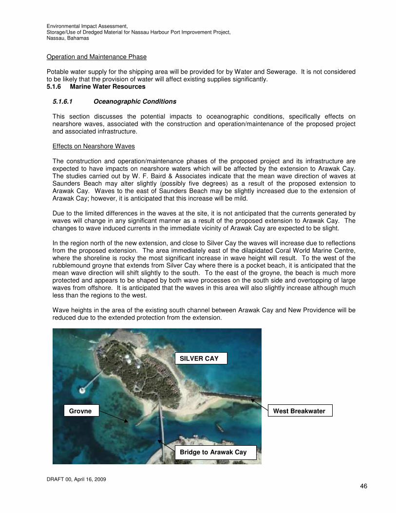
Environmental Impact Assessment, Storage/Use of Dredged Material for Nassau Harbour Port Improvement Project, Nassau, Bahamas
DRAFT 00, April 16, 2009
46
Operation and Maintenance Phase Potable water supply for the shipping area will be provided for by Water and Sewerage. It is not considered to be likely that the provision of water will affect existing supplies significantly. 5.1.6 Marine Water Resources
5.1.6.1 Oceanographic Conditions This section discusses the potential impacts to oceanographic conditions, specifically effects on nearshore waves, associated with the construction and operation/maintenance of the proposed project and associated infrastructure. Effects on Nearshore Waves The construction and operation/maintenance phases of the proposed project and its infrastructure are expected to have impacts on nearshore waters which will be affected by the extension to Arawak Cay. The studies carried out by W. F. Baird & Associates indicate that the mean wave direction of waves at Saunders Beach may alter slightly (possibly five degrees) as a result of the proposed extension to Arawak Cay. Waves to the east of Saunders Beach may be slightly increased due to the extension of Arawak Cay; however, it is anticipated that this increase will be mild. Due to the limited differences in the waves at the site, it is not anticipated that the currents generated by waves will change in any significant manner as a result of the proposed extension to Arawak Cay. The changes to wave induced currents in the immediate vicinity of Arawak Cay are expected to be slight. In the region north of the new extension, and close to Silver Cay the waves will increase due to reflections from the proposed extension. The area immediately east of the dilapidated Coral World Marine Centre, where the shoreline is rocky the most significant increase in wave height will result. To the west of the rubblemound groyne that extends from Silver Cay where there is a pocket beach, it is anticipated that the mean wave direction will shift slightly to the south. To the east of the groyne, the beach is much more protected and appears to be shaped by both wave processes on the south side and overtopping of large waves from offshore. It is anticipated that the waves in this area will also slightly increase although much less than the regions to the west. Wave heights in the area of the existing south channel between Arawak Cay and New Providence will be reduced due to the extended protection from the extension.
Groyne
Bridge to Arawak Cay
SILVER CAY
West Breakwater

Environmental Impact Assessment, Storage/Use of Dredged Material for Nassau Harbour Port Improvement Project, Nassau, Bahamas
DRAFT 00, April 16, 2009
47
Figure 5.2 Aerial photograph of Silver Cay 5.1.6.2 Bathymetry This section discusses the potential impacts to bathymetry associated with the construction and operation/maintenance phases of the proposed project. Alteration of Sea Bottom and Sediment Transport The extension of Arawak Cay will reduce the extent of sea floor by 32 acres and extend the north and south channels adjacent to Arawak Cay. The method of construction will allow bathymetry at the face of the seawalls to remain similar to that existing although some local disruption to the sea bed can be expected as a result of construction. The installation of sheet piles will mean that the change in bathymetry will be abrupt at the face of the sheet piles other than on the north face where scour protection in the form of rock armour is proposed. Overall there will be a reduction in the available area and depths for the flow of water and navigation by sea vessels. This will have an impact on waves and currents, shorelines and shipping and boating which is covered in more detail elsewhere in this report. The use of the area between the two bridges between Arawak Cay and New Providence for the disposal of the return water will also alter the sea bottom and affect sediment transport. Most of the sediment will be contained within the area and cause a temporary rise in the level of the sea bed in the area as this will be excavated following completion of the dredging work. It is considered likely that the material from the return water is likely to be deposited as quicksand. It will therefore be necessary to restrict access to this area and erect signs to warn of the presence of quicksand. Further alterations to the sea bed may also be necessary in order to accommodate many of the shipping vessels. The depths at the extended section of Arawak Cay will not be adequate to accommodate shipping vessels therefore it will be necessary to dredge a channel to enable access to the possible re-located shipping areas. This dredging is not proposed to be carried out as part of this phase of the project however the extension will be built to allow for dredging after construction. 5.1.6.3 Tides and Currents This section discusses the potential impacts to tides and currents, specifically alteration of flow and currents, associated with the construction and operation/maintenance phases of the proposed development and associated infrastructure. Alteration of Flow and Currents The construction and operation/maintenance phases of the proposed project will alter flows and currents due to the use of part of the sea bed as a stilling basin on a temporary basis and the construction of the extension on a long-term basis. The main alterations to flows and currents as a result of the extension to Arawak Cay will be due to the increase in the north and south channel lengths to the west. The extension of the north channel will introduce a reduced cross sectional area at the west end of the channel which will result in greater currents at this location. The use of the area between the two bridges between Arawak Cay and New Providence as a stilling basin for the return water will increase the amount of water flowing through this area. It is estimated that the amount of water that would be introduced to this channel would be approximately 90,000 cubic yards per day, approximately one tenth of the existing flow through the channel. The deposition of the suspended matter in the return water will also reduce the available cross section for the flow of water through the south channel. The turbidity barriers at the bridges will also restrict flows. At present the flow through the south channel accommodates a small portion of the tidal flow (approximately 1%) for the local

Environmental Impact Assessment, Storage/Use of Dredged Material for Nassau Harbour Port Improvement Project, Nassau, Bahamas
DRAFT 00, April 16, 2009
48
area. Also, the use of this portion of the south channel will be temporary. The overall impact to flows and currents in the south channel are expected to be low once an adequate depth of water is maintained in the stilling basin which will also be necessary to allow the suspended matter in the return water ample opportunity to settle as relates to water quality which is discussed below. Other impacts to currents will be those that are wave induced. The impacts to these are discussed elsewhere in this report. 5.1.6.4 Marine Water Quality This section discusses the potential impacts to marine water quality associated with the construction, operation, and maintenance of the proposed project and associated infrastructure. Anticipated indirect impacts to marine water quality from the construction and operation of the proposed project could be long-term and extend beyond the property. Impacts to water quality as a result of stormwater runoff and nutrient loading are discussed above. The categories of potential impact to water quality discussed in this section include the following: • Impacts of runoff, • Impacts of construction and return water disposal, and • Potential deterioration of marine water quality associated with oil spills and releases of hazardous
materials.
5.1.6.4.1 Impacts from Runoff The overall significance of the potential impacts to marine water quality associated with runoff resulting from the proposed project and infrastructure are expected to be moderate. The negative impacts to the nearshore marine waters from the proposed project would be expected to be localised in close proximity to the nearby shoreline. Runoff, in the form of nutrient loading over extended periods, even to well circulated marine waters, can result in degraded conditions unless properly monitored and managed. Fortunately, the area’s predominantly sandy soils would minimise the potential for soils, nutrients or other pollutants to flow overland to marine waters although these could eventually enter the marine waters after infiltration. Construction Phase By staging construction sequencing to minimise areas disturbed at any one time, deploying turbidity barriers and incorporating construction stormwater management techniques, negative impacts to marine water quality is expected to be low during the project’s construction phase. The potential for increased erosion and sedimentation from cleared and exposed surfaces resulting in the transport of sediment and associated nutrients and/or pollutants may negatively impact marine water quality. This situation will partly be addressed by the implementation of a coastal setback and the use of the steel sheet piling to protect the disposed material at the extension. Proper sedimentation and erosion control measures will be installed and maintained where necessary. By implementing proper erosion and sedimentation controls, sediment impacts on the marine water quality from runoff can be minimised, and therefore are anticipated to be moderate. Operation and Maintenance Phase Potential impacts to marine water quality associated with non-point source runoff during the operation and maintenance of the proposed project are anticipated to be low and long-term in duration. Potential impacts to marine water quality include the increased use of fertilizers, pesticides, petroleum products, or other chemicals on the property. Proper land use management practices, should be developed in order to minimise any negative impacts associated with the development. 5.1.6.4.2 Impacts of construction and return water disposal

Environmental Impact Assessment, Storage/Use of Dredged Material for Nassau Harbour Port Improvement Project, Nassau, Bahamas
DRAFT 00, April 16, 2009
49
One of the main concerns with regards to the dredged material disposal is the impacts on water quality, which include those associated with increased turbidity, decreased dissolved oxygen levels, and the release of sediment-bound contaminants. High levels of localised turbidity can be expected during the construction of the extension of Arawak Cay when turbidity will be generated by the backfilling of the reclamation and piling activities. Turbidity will also be increased at the location of the discharge of the return water which will contain suspended matter. Turbidity may also be increased by dredging activities at the west end of the extended north channel. The suspension of fine sediments in the water column creates turbidity, which scatters and attenuates light levels and potentially affects the growth of plants and corals indirectly by reducing the availability of light and consequently the photosynthetic process in plants and coral symbionts. There are many factors that need to be considered in defining the actual extent of the region that may experience some increased turbidity, including the following factors listed below; • Construction methods used by the Contractor in particular backfilling of the extension and return
water disposal methods. • The extent to which the dredging of Nassau Harbour affects the region • The region that may be affected by turbid water will depend on wind and wave conditions that will
disperse the turbid water • Different wave and wind conditions may create an environment where turbidity does not settle due
to the currents and turbulence in the water column. The disposal of water from the stilling ponds typically has a short term (several hours to days) impact on the water column following discharge. This water will contain negatively buoyant solids that sink as a turbid suspension through the water column to the sea floor. This water will be contained within the area between the two bridges between Arawak Cay and New Providence by turbidity barriers at the bridge openings to allow the suspended matter to settle within the area. These turbidity barriers would also remain whilst dredging is carried out after all return water has been returned to sea and suspended matter allowed to settle. It may also be necessary for the Contractor to construct baffle dikes or containment berms to slow the flow of water in this area. Turbidity caused by the construction of the extension to Arawak Cay and the dredging at the west end of the north channel following the construction of the extension will also be contained by turbidity barriers. The type of turbidity barriers and the method of deployment utilised will be dependant on the Contractor. It may also be necessary for the Contractor to construct baffle dikes or containment berms to slow the flow of water at the extension. The turbidity could potentially travel either east or west, north and south of Arawak Cay dependant on the tide (east during flood tide, west during ebb tide). The currents on the north and south sides of Arawak Cay are approximately 1.5 ft/s and 0.09 ft/s respectively hence the turbidity on the north has the potential to travel further than that on the south. It is therefore considered necessary to construct the extension in a manner that will best protect nearby waters during backfilling in particular the reef to the north and west of the proposed extension with these factors in mind. For instance the north face of sheet piling for the extension could be constructed and utilized as protection of the backfill material. In order to measure turbidity levels at appropriate locations during monitoring of turbidity levels a 2,000 foot long mixing zone, in the vicinity of the extension to Arawak Cay, the dredging at the west end of the north channel and the return water discharge point are to be utilised. The mixing zones will shift from one side of the operation to the other, depending on the current direction (generally easterly and westerly). The mixing zones also extend 500 feet offshore. Background and compliance measurements are to be taken for both the extension and nearby dredging and the disposal site mixing zones. The background measurements are to be taken at least 2,000 feet upcurrent from the extension and dredge location and the point where discharge water is returning, clearly outside the influence of any artificially generated turbidity. This is important to note as turbidity will be affected by the dredging activities in Nassau Harbour. This will also affect the mixing zones. Where either the edge of the mixing zone for the extension to Arawak Cay, the dredging at the west

Environmental Impact Assessment, Storage/Use of Dredged Material for Nassau Harbour Port Improvement Project, Nassau, Bahamas
DRAFT 00, April 16, 2009
50
end of the north channel and the return water discharge point is within 3,000 feet of the dredging activities of Nassau Harbour measurements will not be taken for that respective mixing zone as measurements will be taken for the dredging of Nassau Harbour activities. Samples are to be taken within the densest portion of any visible turbidity plume. The northern compliance station for the extension to Arawak Cay and nearby dredging site mixing zone shall be no more than 500 feet offshore from the mouth of the inlet between Silver Cay and Long Cay. This compliance station is to remain stationary throughout the project. The second compliance station at the disposal site shall be no more than 2,000 feet down current from the point where discharge water is returning, within the densest portion of any visible turbidity plume. This compliance station moves when the outfall location changes. All sampling is to be taken at a depth of three feet from the surface at each station and at a frequency of every six daytime hours during initial operations (no more than 10 days) and once per day thereafter. In the absence of legislation with regards to permitted levels of turbidity in the Bahamas it is considered appropriate to refer to those of nearby Florida which of all the states and commonwealths within the United States possessing coral reef resources (e.g., Guam, Puerto Rico, the Virgin Islands, Hawaii and others) Florida stands alone with a standard that is 6 or more times higher than the others. The Florida Department of Environmental Regulation requires turbidity monitoring using the Nephelometric Turbidity Units or NTU's so that during construction, the permitee "shall not exceed 29 NTU's above the associated background turbidity levels as prescribed in the 'Monitoring Required' section pursuant to Rule 62-302, of the Florida Administrative Code".
The waters around Arawak Cay experience variations in turbidity as a result of high winds or the arrival or departure of sea vessels that occur generally every day at the north channel. Due to the duration of the project and the affects of high turbidity on marine life it is considered important that the maximum turbidity level experienced in the area is not increased. Due to the frequency of poor weather conditions and the high costs associated with ceasing work it is not considered feasible to cease work when weather conditions are poor solely due to turbidity. It is considered necessary therefore to use a background turbidity level that reflects turbidity levels whilst turbidity is affected by poor weather. Measurements have been taken prior to commencing dredging in order to determine the turbidity level whilst turbidity is affected by poor weather. These measurements indicate that a background turbidity level of 7 NTU is indicative of such. The pre-determined limit of turbidity levels at the compliance stations for the extension to Arawak Cay, the nearby dredging at the west end of the north channel and the return water disposal site will therefore be 7 + 29 = 36 NTUs. However, if background measurements exceed the pre-determined limit of 36 NTUs, the background measurement shall be used for comparison of compliance measurements. In other words, compliance measurements shall be compared with the daily background measurement or the pre-determined limit of 36 NTUs, whichever is higher. If monitoring reveals turbidity levels at the compliance sites in excess of the limit of 36 NTUs or the background measurements, whichever is higher, construction activities shall cease immediately and not resume until corrective measures have been taken and turbidity has returned to an acceptable level. Any such occurrence shall also be immediately reported to the Project Manager.

Figure 5.3 Turbidity Mixing Zones for Disposal at Arawak Cay Extension and the Return Water Disposal Sites

Environmental Impact Assessment, Storage/Use of Dredged Material for Nassau Harbour Port Improvement Project, Nassau, Bahamas
DRAFT 00, April 16, 2009
52
It must be clear that 29 NTU above background is the absolute maximum we recommend and any exceedance of this value must result in the suspension of reclamation/dredging/disposal operations. In an attempt to prevent instituting serious mitigatory measures (cessation of activities) due to the 29 NTU (above background) maximum being exceeded, a graded system of turbidity concentrations is recommended. Instead of relying on a single turbidity concentration, a maximum at the monitoring sites of 20 NTU (above background) should be used as an early warning indicator. The Contractor would thus be in more of a position to initiate mitigatory measures to avert exceeding the 29 NTU (above background) threshold if he has sufficient warning that this level is being approached. Once the 20 NTU (above background) level is attained or exceeded, the contractor should ensure that the necessary mitigatory steps are taken and documented to prevent a further increase in suspended solids concentration, which could lead to suspension of the operation when 29 NTU (above background) is exceeded. Mitigatory steps would normally involve improvements to the turbidity barrier arrangements, a slower rate of disposal of return water and the use of geotextiles or flocculants at the disposal site. It should be noted that these mitigation measures will add to the cost of dredging. If 29 NTU (above background) is attained or exceeded there should be no debate and the extension to Arawak Cay, associated nearby dredging at the west end of the north channel and discharge operations must be immediately suspended until levels are reduced to below the threshold mark. A report on the exceedance incident should be prepared and only after the environmental officer is satisfied that the situation has been rectified should the operation be resumed. All turbidity measurements are to be compliant with the USEPA Method 180.1. Turbidity monitoring samples shall be taken using a 12 volt DC low velocity sampling pump. The pump shall be thoroughly flushed during each sample taken. Sample shall be placed in a clean collection bottle and placed in a closed container for transport to a controlled location. Each vial shall be clearly marked and labeled. Samples shall then be transferred into the appropriate vial specifically designed for use with the LaMotte 2020 (or similar) turbidity meter. The samples shall then be analyzed. The degree of accuracy shall be less than ±2%. Control depth for extraction of the samples from the water column will be accomplished using a calibrated grade rod indicating water depth at that location. The turbidity meter is to be calibrated at least every week and results reported alongside turbidity results. Daily monitoring reports will include the following information for each sample: a) time of day; b) antecedent weather conditions; c) tidal stage and direction of flow; and d) wind direction and velocity. Reports shall be complied daily even when no sampling is conducted. When sampling is not conducted, a brief statement shall be given to explain the rationale, such as “dredge not working” or “no sampling due to high seas”. Weekly summaries of the daily turbidity monitoring data will be submitted to the Project Manager within one week of analysis with documents containing the following information: 1) dates and times of sampling and analysis; 2) state plane coordinates (X and Y) of the sampling stations and the dredge and discharge locations, and the distance between the sampling stations and the dredge/discharge for each sample to demonstrate compliance with the above required distances; 3) a statement describing the methods used in collection, handling, storage, and analysis of the samples, as well as the authenticity, precision, limits of detection, and accuracy of the data; 4) results of the analysis; and 5) a description of any factors influencing the dredging or disposal operation or the sampling program. The summaries shall be submitted in Excel Spreadsheet (*.xls) format and follow the example in Appendix B. Turbidity barriers or silt curtains are often used to limit the impact of turbidity and will be a requirement of the project. In some cases where relatively quiescent current conditions (0.2 ft/sec or less) are present, turbidity levels in the water column outside the barrier can be 80 to 90 percent lower than the levels inside or upstream of the barrier. While there may be a turbid layer flowing under the barrier, the amount of suspended material in the upper part of the water column, as a whole, is substantially reduced. However, the effectiveness of turbidity barriers can be significantly reduced in high energy regimes characterised by currents and turbulence. High currents cause turbidity barriers to flair, thus reducing the barrier’s effective depth; in fact, in a current of 1 knot the effective skirt depth of a 5 ft barrier is approximately 3 ft. Increased water turbulence around the barrier also tends to re-suspend the fluid material layer and may cause the turbid layer flowing under the barrier to resurface just beyond

Environmental Impact Assessment, Storage/Use of Dredged Material for Nassau Harbour Port Improvement Project, Nassau, Bahamas
DRAFT 00, April 16, 2009
53
the barrier. However, even under moderate currents (up to 0.5 knots), a properly deployed and maintained center tension barrier can effectively control the flow of turbid water (under the barrier). In other cases, where anchoring is inadequate and particularly at sites where tidal currents dominate the hydrodynamic regime and may cause resuspension of the fluid material as the barrier sweeps back and forth (over the fluid material) with changes in the direction of the current, the turbidity levels outside the barrier can be as much as 10 times higher than the levels inside the barrier. With respect to overall effectiveness and deployment considerations a current velocity of approximately 1.5 ft/sec appears to be a practical limiting condition for turbidity barrier use. As mentioned previously the total volume of material to be dredged is estimated to be 2 million cubic yards. Generally, the pipeline conveys 10 percent solids and 90 percent water therefore a total of 18 million cubic yards of water would be piped at approximately 90,000 cubic yards per day. In order to restrict the impacts of the suspended matter in the effluent water it is proposed to utilise the area between the two bridges between Arawak Cay and New Providence for the disposal site for the return water. By placing turbidity barriers or similar at the two bridges the flow of suspended matter will be locally restricted to the area thereby restricting the waters into which the material will impact sea grasses, sponges, reef, other biota and shorelines. Whilst this material would impact on the area between the bridges this area is very shallow with some sea grass beds, sand bottom and empty conch shells. Whilst the turbidity requirements are indicated above it will also be necessary to control the level of effluent solids in order to limit the degree of dredging that is necessary at the disposal site. Preliminary calculations indicate that the area between the two bridges may not be able to contain the suspended matter from the return water for the project however excavation of this area once would provide adequate storage, allowing for a second excavation of the area on completion of the project. Adequate design will therefore be necessary to restrict the level of suspended matter in the return water and thereby restrict the amount of excavation necessary. The introduction of nutrients or organic material to the water column as a result of the discharge can lead to a high biochemical oxygen demand (BOD), which in turn can lead to reduced dissolved oxygen, thereby potentially affecting the survival of many aquatic organisms. Increases in nutrients can favor one group of organisms such as algae to the detriment of other more desirable types such as submerged aquatic vegetation, potentially causing adverse health effects, objectionable tastes and odors, and other problems. The minimum dissolved oxygen at the point of discharge should therefore be restricted to 6.0 mg/l. The temperature of the water can also affect marine inhabitants. Water that is more than 2 degrees fahrenheit above the temperature of water at the point of discharge shall not be discharged into coastal waters during and including the months of July, August and September and 4 degrees Fahrenheit during other times of the year. Furthermore the acidity/alkalinity of the water shall maintain a pH of 6.8 to 8.5. 5.1.6.4.3 Deterioration of Marine Water Quality Associated with Vessels and Oil Spills The proposed project may cause the deterioration of marine water quality as a result of oil spills or releases of hazardous materials. Construction Phase Fuel needed to operate construction vehicles and equipment will be shipped to New Providence and delivered to the property via fuel transport vehicles. Spills or releases that occur at the project site during construction activities have the potential to impact marine waters if these spills occur over water whilst fuelling marine equipment or are permitted to travel over land or through soils to marine environments. Due to this potential, designated fueling areas will be identified by the project Contractors where all fueling activity will take place. These designated areas will at all times have appropriate spill response and recovery equipment so as to minimise any fuel spill.

Environmental Impact Assessment, Storage/Use of Dredged Material for Nassau Harbour Port Improvement Project, Nassau, Bahamas
DRAFT 00, April 16, 2009
54
Operation and Maintenance Phase There will be an increase in the volume of vessel traffic in the waters adjacent to Arawak Cay due to the planned marine facilities. Therefore, there is an increased potential for the release of oil or hazardous materials into the marine waters adjacent to the property. Due to this potential, designated fueling areas will be identified by the project planners where all fueling activity will take place. These designated areas will at all times have appropriate spill response and recovery equipment so as to minimise any fuel spill.
5.1.7 Air Quality and Noise This section discusses the potential impacts to ambient air quality and noise resulting from the construction and operation/maintenance phases of the proposed project. The activities that may result in increased ambient air quality and noise impacts discussed in this section include the following: • Impacts from fuel loading and unloading operations, • Emissions from stationary sources and uncontrolled sources, • Emissions from mobile sources, and • Effects of construction noise or dust. 5.1.7.1 Impacts from Fuel Loading and Unloading Operations The overall significance of the potential impacts to ambient air and noise impacts resulting from fuel loading and unloading operations associated with the proposed project are expected to be moderate. The proposed project will include new stationary and mobile sources that may require the installation of additional diesel and gasoline fueling facilities on the island. These fueling facilities may be required during the construction phase of the project, as well as during the operation and maintenance. Construction, Operation and Maintenance Phases The proposed project will include new stationary and mobile sources that may require the installation of additional diesel and gasoline fueling facilities in the area. There will be ambient air and noise impacts associated with fueling the additional sources; however these impacts will be intermittent, indirect in nature, and short term in duration. Waste oil should be stored in double-wall storage tanks placed in secondary containment facilities. When full, these tanks would be transported off island for disposal. Most impacts from fuel loading and unloading operations will currently exist at the existing shipping locations and will be re-located however impacts are likely to be improved due to improved facilities at the new location. 5.1.7.2 Emissions from Stationary and Uncontrolled Sources The potential ambient air and noise impacts resulting from the new stationary and uncontrolled sources of air emissions associated with the proposed project are expected to be low. Occasionally, low level odours emanate from the dredged material in the immediate proximity of the discharge point. These odours are created by the natural decay of aquatic plant life and are principally due to the minute presence of hydrogen sulfide gas, a natural byproduct of the decay process. Dredged sediment with a high organic content has often undergone long term anaerobic (without oxygen) decomposition in the marine environment. This anaerobic decomposition results in the production of a strong, sulfur odour. The amount of organic content in the material to be dredged is unknown however it is considered unlikely that there will be sufficient quantities to cause intolerable odours.

Environmental Impact Assessment, Storage/Use of Dredged Material for Nassau Harbour Port Improvement Project, Nassau, Bahamas
DRAFT 00, April 16, 2009
55
There are no requirements to keep hydrogen sulfide emissions at or below specified levels in the Harbour area. There are a number of methods that can be used to reduce these emissions that should be used should a problem arise. These include the use of lime additions to the dredged material and the use of material without organics to cover or cap the material that causes the odour. Sensitive equipment can be utilised to ensure that such emissions are acceptable if necessary. 5.1.7.3 Emissions from Mobile Sources The potential ambient air and noise impacts from emissions generated by mobile sources associated with the proposed project are expected to be moderate. Construction Phase Construction activities will have impacts on ambient air quality and noise levels on the property and nearby. Piling, temporary asphalt and concrete manufacturing, as well and the use of transportation vessels and construction vehicles will contribute emissions and noise during construction activities. The potential ambient air and noise impacts from the construction of the project will be intermittent, indirect in nature, and short-term in duration. Refer to below for further discussion relating to construction noise. Operation and Maintenance Phase Vehicular traffic will include cars, trucks and other heavy equipment. There is at present a steady flow of heavy goods vehicular traffic to and from Arawak Cay during the day. The ambient air quality and noise impacts associated with the additional vehicular traffic as a result of the project will be noticeable and will depend on the method used to transport the material from the site and the extent that Arawak Cay is developed as a Port. The ambient air quality and noise impacts associated with the additional ship and boat traffic as a result of the project will be noticeable and will depend on the extent that Arawak Cay is developed as a Port. The positive impact of the project will be the removal of these air and noise impacts from Nassau town. Overall it is considered likely that this impact will be moderate. 5.1.7.4 Effects of Construction Noise and Dust The potential ambient air and noise impacts from construction noise and dust resulting from the proposed development and infrastructure are expected to be low. During construction, dust events will need to be controlled. Dust is currently a problem on Arawak Cay due to the level of heavy goods vehicles using the roads, the lack of vegetation on the edge of the roads, the nature of the soil at the edge of the roads and the material being transported. Dust control measures will be implemented during construction activities on the site and may include seeding, wet suppression, installation of wind screens and barriers, application of soil stabilization agents, and other measures. Dust control measures will also be utilised to suppress dust during the processing of the dredged materials as appropriate. Construction activities other than those directly associated with dredging will typically take place between 7:00 AM and 7:00 PM or as directed by the Engineer. Construction activities directly associated with dredging will typically take place 24 hours a day, seven days per week. Noise emitted from construction equipment and trucks will be minimised through the use of efficient mufflers, resonators, and other sound dampening devices in conformance with applicable requirements and established sound levels. Truck-related noise will be minimised by requiring low travel speeds within the project area, as well as for construction vehicles, arriving at, and departing from the site. Furthermore, equipment idling will be limited, whenever possible. Traffic will be generated by the need to transport material from site clearance activities which will be removed from the site by truck and disposed of in an approved manner. Traffic may also potentially be

Environmental Impact Assessment, Storage/Use of Dredged Material for Nassau Harbour Port Improvement Project, Nassau, Bahamas
DRAFT 00, April 16, 2009
56
generated by the need to transport the dredged material to the proposed use location. An alternative method of transport would be the use of a barge. Improperly sealed trucks transporting the material could lead to material spillages on the road as well as the release of fugitive dust both creating potential hazards to public health and safety. An estimated 1.1m cubic yards of material would be transported requiring approximately 55,000 truck trips (at 20 cubic yards per trip). This level of traffic would lead to a worsening of local traffic conditions, which are already congested. It will be necessary to schedule any construction related trips during the off-peak hours to cause minimal impact. It is recommended that the material is barged where feasible in order to reduce the impact of traffic. In the absence of noise regulations in the Bahamas, for the purposes of this document, an average daytime noise level of 70 dB(A) or higher is considered a good indication of a significant noise impact on sensitive land uses when the noise source would not operate at night. When both daytime and nighttime operation of a noise source is anticipated, then a CNEL level of 60 dB(A) or more would indicate a significant noise impact. A number of various types of equipment would be utilised in the storage and use of the dredged material including pile driver(s), backhoes, concrete mixers and pumps, compactors, pavers, trucks and generators all of which emit noise levels between 80 and 101 dB at 50 feet. Given the proximity of the piling operation (the loudest equipment) to residential areas, the noise generated by the extension of Arawak Cay may cause a level of auditory discomfort, especially at night, which is difficult to evaluate in the absence of any noise measurements for similar piling projects. It is estimated that the piling equipment could have a noise level of 101 dB at 50 feet, 70 dB at 1,500 feet and 60dB at 3,000 feet. Figures 5.4 and 5.5 indicate the areas which would experience noise levels of 60 dBA and 70 dBA by pile driving however this will be dependant on the piling technique, pile diameter, local geology and bathymetry. It should be noted that most of the properties affected by the noise from the pile driving are currently affected by traffic noise from West Bay Street. Traffic noise pollution on West Bay Street is estimated (based on traffic flows and road geometry) to average approximately 65 dB and a maximum of approximately 75 dB 30 feet from West Bay Street during peak traffic flow times (between 6-9am and 3-6pm). Therefore the average traffic noise can be expected to be slightly exceeded at West Bay Street as a result of the piling. Given the close proximity of the Fish Fry and residents to the proposed extension works and the duration of the works, it will be necessary to restrict piling operations to between 7:00 am and 7.00 pm. There are no churches in close proximity to the site however it is suggested that piling operations are restricted to six days per week where the construction schedule allows. The acoustic impedance of fish nearly matches that of water, so much of the sound energy will enter their bodies if they are in the vicinity of the source. Studies show that fish suffer damage to their auditory system as well as other parts of their bodies and may even die when exposed to sufficient sound pressure levels underwater for relatively short periods of time. High levels of mortality have been found in fish exposed to 177dB of sound and the threshold for internal injures to fish is around 160dB. On the basis of available data and the variable response of fish to noise sources, typically a sound pressure level of 150dB is adopted as a maximum threshold for bony fish, below which direct harm is unlikely to occur (Hastings 1991). It is anticipated that the level of noise from pile driving activities would not exceed 150 dB and therefore fish would not be adversely affected other than in moving away from the area. All feasible measures to keep noise levels to a minimum should be adopted by the Contractor. Blasting is not to be permitted without obtaining approval from the BEST Commission. Noise from the operation of the shipping area to adjacent properties will depend on the proposed level of activity, equipment to be used, hours of operation and layout. Further consideration to noise and dust will need to be given to the project once a master plan for the shipping area has been determined.
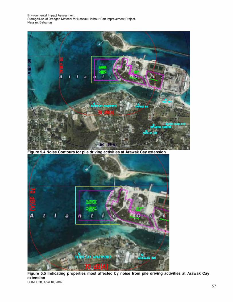
Environmental Impact Assessment, Storage/Use of Dredged Material for Nassau Harbour Port Improvement Project, Nassau, Bahamas
DRAFT 00, April 16, 2009
57
Figure 5.4 Noise Contours for pile driving activities at Arawak Cay extension
Figure 5.5 Indicating properties most affected by noise from pile driving activities at Arawak Cay extension

Environmental Impact Assessment, Storage/Use of Dredged Material for Nassau Harbour Port Improvement Project, Nassau, Bahamas
DRAFT 00, April 16, 2009
58
5.2 Potential Biological Resource Impacts 5.2.1 Terrestrial Biological Resources This section discusses the potential impacts to terrestrial biological resources resulting from the construction and operation/maintenance of the proposed project. Potential impacts on the biological resources resulting from the proposed project and associated infrastructure, both positive and negative, are described in the following sections. The categories of potential impacts to biological resources discussed in this section include the following: • Clearing of vegetation; • Risk of introduction of foreign diseases, parasites, and escape/accidental release of pets; • Impacts to wildlife habitat and threatened species; and • Impacts to harvested, protected, and threatened species and migratory birds. 5.2.1.1 Clearing of Vegetation The overall significance of the potential impacts resulting from the clearing of vegetation as a result of the proposed project are expected to be low. The amount of vegetation being cleared will be minimised to the greatest extent practicable. The project would not result in a loss of any unique terrestrial communities or threatened wildlife populations. Construction Phase Following mobilization, construction operations will begin with the clearing of trees and scrubs from areas where stockpiles are to be located. The areas to be cleared account for approximately 19 acres of trees and scrubs. Slash and timber with little or no value could be chipped on-site. Chips could remain on-site in stockpiles for later use to stabilise construction roadways or may be hauled to a designated area on the property for other uses. Tree stumps could also be ground into chips. It is considered more likely that all vegetation will be removed from the site by truck and disposed of in an approved manner. Although the project would result in direct and long-term impacts from clearing existing vegetation, the bulk of the alteration to vegetation communities will occur within areas where a large majority of the vegetation consists of invasive species, which are relatively abundant and exist throughout New Providence. The impact of the loss of vegetation on wildlife habitat is considered insignificant as the trees and shrubs provide little food or shelter. The use of the area between the two bridges between Arawak Cay and New Providence as a stilling basin for the disposal of return water will impact a small area of silver buttonwood north east of the west bridge. Silver buttonwood is a mangrove shrub with value and as such it is recommended to re-locate these plants. Operation and Maintenance Phase Operation and maintenance activities are likely to result in additional clearing of vegetation. To the extent possible, native plant materials throughout the site should be salvaged and transplanted within the developed areas. New plantings should also be incorporated in the new development. 5.2.1.2 Risk of Introduction of Non-native Species, Foreign Diseases, and Escape of Pets The overall significance of the potential impacts associated with the risk of introduction of non-native species, foreign diseases, and escape of pets resulting from the proposed development and infrastructure are expected to be moderate. The potential for propagation of non-native species and introduction of foreign species in landscaping may indirectly result in long-term impacts to native plant and wildlife populations.
Environmental Impact Assessment, Storage/Use of Dredged Material for Nassau Harbour Port Improvement Project, Nassau, Bahamas
DRAFT 00, April 16, 2009
59
Construction and Operation/Maintenance Phases During construction activities, increased trade, transport, and travel to the property would result in a greater potential for the possibility of the introduction of non-native and invasive species. Site disturbance and removal of vegetation will render areas more vulnerable to colonization by the invasive plant species such as those which are already present on the property. A program to effectively monitor the spread of non-native vegetation, in particular Australian pine, should be implemented. 5.2.1.3 Impacts to Wildlife Habitat The overall significance of the potential impacts to wildlife habitats resulting from the proposed project are expected to be low mainly due to there being minimal wildlife on and around Arawak Cay. This is due to the fact that there is minimal existing terrestrial vegetation communities on the property that provide food or shelter. Construction, Operation and Maintenance Phases It is expected that the temporary displacement of bird populations would result from the disturbance associated with construction and clearing of vegetation. Bird species utilising the project area for feeding, nesting, or roosting purposes are likely to temporarily relocate to portions of New Providence not disturbed by construction activities. As such, avian species using these habitats will be most impacted by construction. 5.2.1.4 Impacts to Threatened and Protected Species and Migratory Birds The overall significance of the potential impacts to threatened and protected species, and migratory birds resulting from the proposed project and infrastructure is expected to be low. No protected species were found at the site. Migratory shorebirds would be impacted during construction due to the activities near the shoreline. However, migratory birds were not found to inhabit Arawak Cay. Long-term impacts to migratory shorebirds are anticipated to be low, long-term but limited to the area local to Arawak Cay. The principal impacts to birds will derive primarily from alterations to vegetation (i.e. loss thereof) and greater vehicular and pedestrian traffic. Operation and maintenance of the project facilities would not create additional impacts to harvested or protected species beyond those described above. 5.2.2 Aquatic/Marine Biological Resources This section discusses the potential environmental impacts to aquatic/marine biological resources associated with the construction and operation/maintenance of the proposed development and associated infrastructure. The nature and extent of the anticipated impacts are described below. The categories of potential impact to marine biological resources discussed in this section include the following:
• Impacts to aquatic/marine habitats; • Impacts to aquatic/marine biota associated with deterioration of water quality; • Effects of using biocides and pesticides on aquatic/marine biota; • Impacts to marine biota associated with boating, fishing, and other recreational activities; • Impacts to aquatic/marine biota associated with oil spills; and • Impacts to commercially important species and habitat.
5.2.2.1 Impacts to Aquatic/Marine Habitat The overall significance of the potential impacts to marine benthic habitats resulting from the proposed project and infrastructure is expected to be moderate.

Environmental Impact Assessment, Storage/Use of Dredged Material for Nassau Harbour Port Improvement Project, Nassau, Bahamas
DRAFT 00, April 16, 2009
60
Construction Phase The impacts to marine habitats are expected to be moderate given that construction activities will take place within the marine environment. The reclamation will smother some areas of the benthic community, either directly or through drifting of fill during reclamation, the disposal of return water and dredging. The construction of the extension of Arawak Cay will result in irreversible loss of the existing sea grass and coral communities living on the seabed where land is to be reclaimed. The area that will be directly affected is approximately 32 acres, approximately 14 acres of which is medium density sea grass beds and the remainder of which is sand or very low density sea grass bed. It should be borne in mind that corals in this area are very scarce and very small. Another area of sea grass that will be impacted is between the two bridges between Arawak Cay and New Providence. The total area of sea grass that would be lost at this location is approximately 2 acres. Sea grasses, the most common tropical shallow-water environment worldwide, grow in a few inches of water or up to depths of 100 ft and more and cover thousands of acres of the Bahamian waters. The grass blades trap sediment by forming a small forest of leaves and provide food and a refuge for fish, crabs, and other marine life that are critical to sustaining the benefits derived from all aspects of the commercial and recreational fisheries. Numerous species of reef fish use sea grass as a protective nursery, hiding amid the grass from predators. Moreover, adult fish that hide in the coral reef during the day and venture out at night to feed, take advantage of the rich source of food that exists in the sea grass. Sea grass also stabilises sediment and traps small particles, helping to maintain the clear waters of The Bahamas by reducing nutrients in the water column, and are important components in energy and nutrient cycles, and in coastal food webs. When sea grass beds are destroyed, the water can become more turbid, making the area an unsuitable habitat for many animals and less attractive for use by tourists. The reef between Silver Cay and Long Cay could potentially be impacted by turbidity caused by reclamation activities to extend Arawak Cay. The impacts are expected to be low due to the flow of water between these islands being predominantly caused by wave action and therefore in a southerly direction. The sheltered location of the reclamation should also allow for the use of turbidity barriers around the complete works at all times thereby further restricting any turbidity impacts. It is recommended that the finger corals and sponges on the face of the existing sea wall where the extension to Arawak Cay will cover portions of the existing wall and for a distance of 100 feet beyond be relocated. These should be relocated to the existing faces of Arawak Cay that would be least affected (i.e. the north and east faces) only if a better alternate location can not be used. Whilst these corals and sponges are not particularly rare and are small it is estimated that there are approximately one thousand that would be affected. Operation and Maintenance Phase In general, potential impacts, associated with the operation and maintenance of the proposed shipping area to the aquatic/marine benthic habitats located on the property are expected to be low, indirect in nature and long-term in duration. Potential impacts associated with operation and maintenance activities are described below for coral reefs, sponges and sea grass beds found in the nearshore waters in proximity to the area. Due to the waves and currents between Silver Cay and Long Cay and reef to the west, minimal impacts are anticipated at the coral reefs in the area due to operation and maintenance activities. It is anticipated that the reefs will continue to provide structure and habitat for a variety of fish and invertebrates. Impacts to the coral reefs would likely include activities associated with fuel spills and increased sea traffic to the area. Additionally, there is a potential for increased macro algal growth associated with non-point source nutrient runoff. Pollutant management measures shall be outlined within the EMP to minimise these impacts to the extent practicable. Project related impacts to the sea grass beds/sandy sea bed located in the waters adjacent to the project site could be impacted by boat propellers, additional rubbish from increased boat traffic and fuel spills.

Environmental Impact Assessment, Storage/Use of Dredged Material for Nassau Harbour Port Improvement Project, Nassau, Bahamas
DRAFT 00, April 16, 2009
61
None of the benthic communities identified included unique or endangered species. Observations revealed that the area of the proposed extension consists primarily of medium coarse sand and sea grass beds. The local effects on water quality of moored vessels flushing their waste tanks into the sea is a concern and the risk of commercial pollution from commercial traffic is a concern mainly due to the close proximity of the reef to the north and west. There will also be an increase of sea traffic in the area when compared to the without project situation. Due to the closer proximity to the west reef an increase in risk can be anticipated from development of the new site for shipping facilities versus the current situation. There is an advantage in taking away commercial activity and related additional pollution/accident risk from the recreational yachting, boating and tourist areas near the centre of town. The existing location used for shipping is more sheltered than Arawak Cay therefore there would also be an increased risk of accidents at Arawak Cay and the sinking of vessels. Whilst the reason for presence of the existing sunken vessels in the north channel is unknown it is considered likely that this is a risk that should be further considered before moving shipping facilities to Arawak Cay. An increase in accidents involving large sea vessels at sea could potentially have a significant impact by contaminating the marine environment. Such risks would also increase the potential for damage to the existing bridge to Silver Cay. 5.2.2.2 Impacts to Aquatic/Marine Biota Associated with Deterioration of Water Quality The overall significance of the potential impacts to aquatic/marine biota from the deterioration of water quality associated with the proposed project and infrastructure are expected to be low, indirect in nature, and long-term in duration. Construction Phase The water quality impacts from the construction of the project are expected to be low. Impacts to the aquatic/marine biota in the immediate project vicinity would mainly be due to sediment from reclamation and return water disposal activities where there would be a direct loss. Nearby areas that would experience less sedimentation on the sea bed would also be affected. Disposal operations will cover established bottom communities at the site with dredged material which may or may not resemble bottom sediments at the disposal site. Recolonisation of animals on the new substrate and the vertical migration of benthic organisms in newly deposited sediments can be important recovery mechanisms. Trends toward reestablishment of the original community are often noted within several months of disturbance, and are often dependent upon the nature of the adjacent undisturbed community, which provides a pool of replacement organisms capable of recolonising the site by adult migration or larval recruitment. Organisms have various capabilities for moving upward through newly deposited sediments, such as dredged material, to reoccupy positions relative to the sediment-water interface similar to those maintained prior to burial by the disposal activity. Vertical migration ability is greatest in dredged material similar to that in which the animals normally occur and is minimal in sediments of dissimilar particle-size distribution. Bottom dwelling organisms having morphological and physiological adaptations for crawling through sediments are able to migrate vertically through several inches of overlying sediment. However, physiological status and environmental variables are of great importance to vertical migration ability. Suspended sediments would reduce the ability of sunlight to penetrate through the water column, potentially limiting the productivity of photosynthetic organisms such as phytoplankton, macro algae, and corals, and could inhibit the foraging efficiency of some finfish and macro benthic organisms. Appropriate sedimentation control barriers will be used to contain the disturbance to the immediate work areas, and to prevent to the extent practicable, any impacts associated with turbidity to the surrounding biological community. Any impacts to the aquatic/marine biota of the project site attributable to construction activities is anticipated be short-term in duration, as these impacts would only occur during the project’s construction phase. The loss of sea grasses and sponges as a result of the extension to Arawak Cay as well as the use of the area between the two bridges between Arawak Cay and New Providence as a stilling basin and the dredging will have an impact on the water quality as due to their value in improving water quality. It is

Environmental Impact Assessment, Storage/Use of Dredged Material for Nassau Harbour Port Improvement Project, Nassau, Bahamas
DRAFT 00, April 16, 2009
62
recommended that sea grasses are therefore re-located. Since the better quality sea grasses are located at the proposed dredge site in Nassau Harbour it is considered most appropriate to re-locate these sea grass beds in the first instance and if possible any further re-location of sea grasses from the area where Arawak Cay is to be extended There are now ample research results indicating that the traditional fears of water-quality degradation resulting from the resuspension of dredged material during dredging and disposal operations are for the most part unfounded. The possible impact of depressed levels of dissolved oxygen has also been of some concern, due to the very high oxygen demand associated with fine-grained dredged material slurry. However, even at open-water pipeline disposal operations where the dissolved oxygen decrease should theoretically be greatest, near-surface dissolved oxygen levels of 8 to 9 ppm may be depressed during the operation by only 2 to 3 ppm at distances of 75 to 150 ft from the discharge point. The degree of oxygen depletion generally increases with depth and increasing concentration of total suspended solids; near-bottom levels may be less than 2 ppm. However, dissolved oxygen levels usually increase with increasing distance from the discharge point, due to dilution and settling of the suspended material. It has been demonstrated that elevated suspended solids concentrations are generally confined to the immediate vicinity of the dredge or discharge point and dissipate rapidly at the completion of the operation. As turbidity will be used as a basis for evaluating the environmental impact of the dredging or disposal operations, it is essential that the predicted turbidity levels are evaluated in light of background conditions. Average turbidity levels, as well as the occasional relatively high levels that are often associated with naturally occurring storms, high wave conditions, and floods, should be considered.
Operation and Maintenance Phase The use of the project area for shipping will introduce an increase in chemicals that are likely to enter the marine environment. These could indirectly negatively impact marine biota by increasing the likelihood of algal blooms and by contributing to decreased water quality and clarity, which can be impede the foraging of some fish and macro benthos, especially those that filter water as a feeding mechanism. The management of stormwater runoff from the project site should help to reduce runoff and its associated impacts on marine biota. The main impacts on water quality will be from fuel spills and waste as a result of the increased sea traffic which is discussed further below. These impacts will be long-term in duration however they are impacts that exist at present and will be re-located. Overall the impact is therefore considered low. 5.2.2.3 Effects of Using Fertilizers, Biocides, and Pesticides on Aquatic/Marine Biota The overall significance of the effects of using fertilizers, biocides, and pesticides on aquatic/marine biota resulting from the proposed project are expected to be low, indirect in nature, and long-term in duration. Construction Phase Impacts due to the use of fertilizers, biocides, and pesticides during the construction phase of the project are anticipated to be low. Whilst the Contractor is expected to maintain their equipment no major painting of vessels should be necessary during the project. Operation and Maintenance Phase Potential impacts to marine biota from the use of fertilizers and pesticides during operation and maintenance of the project are anticipated to be low and long-term in nature. Typically these impacts result from the accumulation of substances (fertilizers, biocides, and pesticides) in surface water, groundwater, marine sediments, and stormwater runoff. Pesticides would only be applied as to maintain any landscaped areas which will be limited in extent due to the nature of the proposed use of the area. Biocides are generally used in anti-fouling bottom paints to chemically or microbiologically combat deposits and growth of bacteria, plants, or animals on boats. The project will increase sea vessel traffic in the area which in turn will increase the presence of residual biocides.

Environmental Impact Assessment, Storage/Use of Dredged Material for Nassau Harbour Port Improvement Project, Nassau, Bahamas
DRAFT 00, April 16, 2009
63
If stormwater runoff is not properly managed, the accumulation of pesticides and fertilizers can negatively impact the adjacent marine habitat, and lead to eventual changes in ecosystem function however their use is unlikely. Those organisms that would be the most readily impacted by fertilizers, pesticides and biocides include the phytoplankton, zooplankton, and benthic organisms. Biocides which reach aquatic/marine habitats may cause the mortality of a variety of marine invertebrates and fish. Sign boards should be erected close to areas where sea vessels moor to educate users of the area of laws and good practice with regard to the handling of waste, oil, fuels, biocides, etc. If boat building practices are to continue to operate on Arawak Cay that a sealed surface is provided at these areas to restrict chemical spills from entering the marine environment. 5.2.2.4 Impacts to Biota Associated with Boating, Fishing and Other Recreational Activities It is anticipated that the overall impacts to biota associated with boating, fishing and other recreational activities will be low and indirect in nature although long-term. Construction Phase During the construction phase, the boating associated with deploying turbidity barriers and the pipeline for transporting the dredged material, transport of staff, turbidity monitoring, etc. will have an impact however this is unlikely to be significant due to the existing amount of boating activity in the area. Operation and Maintenance Phase Impacts to aquatic/marine biota are anticipated to be low and short-term during the operation and maintenance phase of the proposed project due to boating, fishing, and other recreational activities. It is likely that some species of fish and macro benthos will seek protection in areas of the reefs when sea vessels pass. This instinctual behavior will be localised and short-term and not result in any prolonged affects after the sea vessels have left the immediate area. Additionally, increased fishing pressures may affect local fish population in the general project area. However, the absence of large fish populations combined with appropriate environmental education, in the form of signs posted at any public access points, should minimise the impacts of increased fishing pressures in the nearshore marine waters adjacent to the project area. 5.2.2.5 Impacts to Aquatic/Marine Biota Associated with Oil Spills The overall significance of the potential impacts to aquatic/marine biota associated with oils spills resulting from the proposed project are expected to be low. Impacts of this nature are mainly attributed to the intentional or unintentional release of petroleum products and other hazardous materials from boating activities. Boating in the vicinity of the project will increase mainly during operation and slightly during construction activities. Should an oil spill occur, the anticipated impacts to aquatic/marine biota are anticipated to be moderate in significance, and potentially long-term in duration. Spills and releases of fuels and other hazardous materials into the marine environment have the potential to directly negatively impact marine biota that either becomes externally coated with the spilled material, or ingests water or other organisms impacted by the material. In the event that an oil spill were to occur in the marine waters adjacent to the property the response actions detailed in the SPCC plan would be implemented to contain the spill and reduce potentially detrimental impacts to the marine environment. 5.2.2.6 Impacts to Commercially Important Species and Habitats The overall significance of the potential impacts to commercially important species and habitat resulting from the proposed project and infrastructure are expected to be low, indirect in nature, and short-term in duration. Some important managed fisheries in The Bahamas include spiny lobster, conch, turtle, grouper, rockfish, stone crab, sponge, and various other fish species. The nearshore waters adjacent to the project
Environmental Impact Assessment, Storage/Use of Dredged Material for Nassau Harbour Port Improvement Project, Nassau, Bahamas
DRAFT 00, April 16, 2009
64
may support local commercial fisheries or nursery habitat for commercial fish species but this is minimal due to the area not being a regular fishing ground. On-site reconnaissance of the nearshore waters adjacent to the project area suggests that they support a small population of fish species of minor economic importance. Due to the low numbers of economically important species impacts to commercially important marine fish species and habitat are expected to be low during all phases of the project. 5.3 Potential Socioeconomic and Cultural Impacts This section describes the potential socioeconomic impacts expected from the construction and operation/maintenance of the proposed project. The development of the improvements to Nassau Harbour will provide employment opportunities for Bahamians and others, and should expand the local economy, which may affect demographics such as population growth. Potential effects on displacement and resettlement, fisheries exploitation, tourism, land values and cultural resources are also considered in this section however only in relation to the storage and use of the dredged material including the extension of Arawak Cay with consideration given to its accommodating shipping from West Bay Street and Potters Cay. 5.3.1 Demographics The overall significance of the potential impacts on demographics resulting from the proposed project and associated infrastructure is expected to be low but positive, direct in nature, and long-term in duration. The duration of the direct impacts would be both short-term (during construction) and long-term (during operation and maintenance). Construction Phase The Contractor will make reasonable efforts, to employ as many qualified Bahamians as possible at all levels, provided the level of expertise and skilled labor is locally available to construct a quality extension to Arawak Cay and stored dredged material area within the construction schedule. The scale and complexity of the proposed construction will require the involvement of major international construction companies and consultants with proven experience to meet the exacting standards of efficiency and quality required to conduct a major dredging project. The Government and the construction contractors will use their best efforts to ensure that meaningful arrangements are made, when possible and appropriate, with Bahamian companies to provide labor assistance during construction. Temporary housing and sanitation facilities will be provided for construction workers, as needed. Operation and Maintenance Phase The operation and maintenance of the shipping area will re-locate existing jobs and potentially rely on qualified local Bahamians to fill jobs. 5.3.1.1 Displacement and Resettlement of Existing Housing The overall significance of the potential impacts of the displacement and resettlement of existing housing resulting from the proposed development and infrastructure are expected to be low. Construction and Operation/Maintenance Phases There are presently no residents on the property, and no habitable permanent or seasonal housing. Therefore, the project will not directly displace or require resettlement of any residents. However, it is possible that nearby residents may choose to resettle either temporarily or permanently due to construction or operation and maintenance activities. Therefore, some indirect negative impacts of low significance are possible near the project area. These impacts are expected to be short-term.
Environmental Impact Assessment, Storage/Use of Dredged Material for Nassau Harbour Port Improvement Project, Nassau, Bahamas
DRAFT 00, April 16, 2009
65
5.3.2 Economic Activities The economic expansion anticipated by the project should increase the GDP in The Bahamas. Potential economic impacts due to construction, operation and maintenance of the project that are assessed in this section include the following:
• Effect on direct and indirect employment; • Impacts on existing and future fishing and fisheries exploitation; and • Impacts on public health and worker health and safety.
5.3.2.1 Effect on Direct and Indirect Employment Overall, the significance of the effects on direct employment at the project, and indirect employment at off-site businesses is expected to be low and positive. The project will have beneficial impacts on short-term and long-term employment opportunities in The Bahamas. Increased employment is expected in the construction and transportation sectors in particular. Also, the project workforce will provide a potential clientele for the nearby restaurants such as those at the Fish Fry and the cricket club adjacent to the site. 5.3.2.2 Impact on Existing and Future Fishing and Fisheries Exploitation The overall significance of the potential impacts on existing and future fishing and fisheries exploitation resulting from the proposed development and infrastructure are expected to be moderate. Fishing could potentially be affected negatively in the short term by the storage and use of the dredged material from Nassau Harbour as proposed by the affects of turbidity, vibration and noise caused by the pile driving, disposal of return water, dredging and possibly by blasting. Fishing could also potentially be affected negatively in the long term indirectly through the loss of sea grasses and coral. This project would potentially impact the fishing industry by restricting access to the area behind the Fish Fry to fishermen and altering the area in which they can store their livestock as an alternative location will need to be provided. It is recommended that a permanent alternative means to store livestock be provided nearby due to the likelihood of water quality in the area being impacted as a result o the activities that will take place during and after construction (i.e. moored vessels flushing their waste tanks into the sea). Also, the project could impact the level of business at the Fish Fry and the cricket club due to increased noise, dust, odour and traffic. These locations are well known for their seafood dishes. In the wider context of the development of Nassau Harbour, the industry would benefit from both direct and indirect spin-offs associated with increased tourism and trade. Also extension to Arawak Cay could potentially provide fishermen with improved facilities to that offered elsewhere. Apart from incidental recreational-type hand fishing done from the shoreline, no commercial fishing normally takes place at Arawak Cay, although the waters behind the ‘Fish Fry’ are often used to store livestock. It is possible that some fishing activities are carried out in the area that could potentially be affected by turbidity from construction activities. In that case, work could have an impact on local fishery activities through the generation of turbidity and dispersed sediments which will cause fish to inhabit other areas and prevent fishermen being able to see and find their fish pots and cause suffocation of fish caught in traps. It should be noted that spear fishing is prohibited within one mile of New Providence and should therefore not be affected. 5.3.2.3 Impacts on Public Health and Worker Health and Safety

Environmental Impact Assessment, Storage/Use of Dredged Material for Nassau Harbour Port Improvement Project, Nassau, Bahamas
DRAFT 00, April 16, 2009
66
Potential impacts on occupational and public health and safety resulting from the project will be minimised by the following measures, and therefore are expected to be low. Construction and Operation/Maintenance Phases There are potential impacts to worker safety during the construction and operation phase due to the increased activities in the project area and the higher population of workers. During construction and operation, the potential impacts to worker safety include construction related hazards from working at elevation, over water, near unstable ground, and near heavy equipment. The potential impacts to worker safety during operation include increased fire hazards and hazards associated with high-pressure systems. To maximize safety for staff and visitors, the Contractors will be responsible for developing health and safety protocols for use during construction. The selected construction Contractor will be responsible for preparing the detailed health and safety plan for use during construction, in accordance with Bahamian, U.S., and/or international health and safety standards, as appropriate. Health and Safety protocols and operating procedures will also be prepared for use during operation and maintenance of the shipping facilities, in order to safeguard workers and visitors. A thorough and ongoing training program for site workers will focus on steps to minimise potential accidents. Security will be provided to ensure safety. The protocols will include a SPCC Plan so as to minimise releases to the environment of oil or hazardous materials associated with the project. If additional police, fire, medical, and other community services are needed due to increased demands as a result of the project, the government should upgrade these community services and facilities. The directly negative impacts during both the construction and operation and maintenance phases are expected to be low, long-term, and limited to the project area. 5.3.3 Tourism The project, in the context of the Nassau Harbour Improvements Project is expected to sustain and possibly increase tourism on New Providence, and may also increase tourism to other islands. Visitors to Nassau will each contribute to a growing tourist economy. In this respect the overall impacts of tourism are anticipated to be high, positive, and long-term in duration. 5.3.3.1 Effect on Existing and Future Land Use Values The land proposed for the project is currently unoccupied and undeveloped or sea bed. The area is void of any habitable structures and there is little infrastructure in the form of utilities. Development of the project and infrastructure would increase the property’s land use values. The re-location of the shipping from the tourist town area will improve the area and allow further development to attract tourists however it re-location to Arawak Cay will have a lesser impact on the nearby tourist attractions. Overall, the significance of these direct, long-term impacts will be positive. 5.3.3.2 Impacts to Shipping and Boating The overall significance of the potential impacts on shipping and boating resulting from the project will be moderate, generally positive, indirect in nature, long-term in duration, and occur primarily during the project’s operation and maintenance phase. The storage of the dredged material from Nassau Harbour and the extension of Arawak Cay should not hinder existing commercial shipping activities due to the fact that most commercial vessels do not venture to areas of Arawak Cay other than the north east end from the east. This is most likely due to proximity to the harbour entrance, the lack of operations located at this end of the island, limited water depths and the presence of a sunken vessel in the west end of the north channel. Where a pipeline is to be utilised to
Environmental Impact Assessment, Storage/Use of Dredged Material for Nassau Harbour Port Improvement Project, Nassau, Bahamas
DRAFT 00, April 16, 2009
67
transport material this pipeline is to be placed so as to cause minimal disruption to marine traffic. Adequate lighting, sufficient for night time vessel operations, will be required to mark the construction activities and all floating pipeline. A section of the submerged pipeline where there is sufficient water depth for safe vessel crossing is to be designated and marked. The extents of the newly extended Arawak Cay should be well identified by lighting. The proposed extension of Arawak Cay will reduce the width and depth of the channel between the north side of Arawak Cay and Silver Cay. At present the minimum depth along the deepest route between the bridge to Silver Cay and the area to the west is 9 feet MLWS. Once the extension is constructed the minimum depth along the deepest route between the bridge to Silver Cay and the area to the west will be 2.5 feet MLWS thereby limiting the size of vessels that are able to pass through the area immediately the to the west of the groyne that extends in a South westerly direction from Silver Cay and increasing currents. There are few boats that require less than 2.5 feet draft therefore most boats other than skiffs would not be able to traverse this area at low tide. The mean tidal range is approximately 2.5 feet therefore more vessels would be able to traverse the area when the tide is high. A large number of boats use the existing north channel as a sheltered east-west route along the north side of New Providence, most notably the tourist excursion boats. Without adequate available draft for their vessels in the north channel they would be forced to travel on the north side of the west breakwater, Silver Cay and Long Cay where they would be exposed to larger waves. Whilst consideration has been given to possible reliance on natural scour to provide navigable water depth between Silver Cay and the Arawak Cay Extension this is not recommended as seagrasses currently provide stability in this area and if scour were to occur this would take a good while to provide adequate depth to achieve navigable water depth effectively blocking this north east route that is used regularly by boaters to access the protected area on the south side of Arawak Cay as well as by excursion boats to transport tourists to the nearby Cays. Dredging or alternative means to maintain a navigable channel directly to the west of the rubble groyne that extends from Silver Cay for these vessels on completion of construction is therefore recommended. The use of the area between the two bridges between Arawak Cay and New Providence as a stilling basin for the return water will make this area inaccessible to small skiffs. With the south channel blocked these skiffs will have to travel an extended route through the north channel to access sheltered waters on the south side of Arawak Cay to moor their boats and off-load. Should it be feasible to barge the material stored at Arawak Cay to its location for use this should be carried out in a manner so as not to cause hindrance to shipping. Loading of material should be carried out at the extended end of Arawak Cay causing least hindrance to shipping and boating however it is likely that dredging would be necessary in order for a barge to be able to access this location. Users of the harbour and waters surrounding Arawak Cay are to be advised of the details of the operations, submerged pipeline and alterations made as part of the project by notification in the newspapers and radio as well as letters to the local residents, boating operations and operators at Arawak Cay and a Public Meeting. Turbidity of the waters around Arawak Cay will make it more difficult for boat captains to see in the water. It will therefore be necessary to remove the sunken vessel from the north side of Arawak Cay prior to the commencement of dredging activities. It may also be necessary to dredge the sand that has collected around the vessel. There will also be an impact on recreational or sport use of the area where the extension to Arawak Cay is to take place as this is a well sheltered area where boaters have been known to water ski, wakeboard, wakeskate, etc. 5.3.3.3 Impacts on Public Access and Use of Coastal Resources The overall significance of the potential impacts on public access and the use of coastal resources resulting from the project could be moderate, generally negative, indirect in nature, long-term in duration, and occur primarily during the project’s operation and maintenance phase however this will depend on planning
Environmental Impact Assessment, Storage/Use of Dredged Material for Nassau Harbour Port Improvement Project, Nassau, Bahamas
DRAFT 00, April 16, 2009
68
details. The public currently access the shoreline around Arawak Cay to park their vehicles and access boats, line fish, relax or dispose of items. Construction Phase The project area contains roads that provide access through the property to the shoreline. Public access and the use of coastal resources adjacent to the area may be temporarily limited during the construction of the project. Coastal resources will remain available to the public throughout construction; however, existing public access to these resources may be blocked by construction activities and equipment and the public may be diverted to an alternate access route. A majority of the existing roads will remain during construction therefore, public access to the shoreline is likely to remain throughout the project’s construction phase. Operation and Maintenance Phase The overall significance of the potential impact on public access to the shoreline will be negative and is likely to be moderate. The severity of the impact will be highly dependant on the plans for the proposed shipping area. Public access and designated parking spaces will be provided on the island by way of the road network established for the development however access to the shoreline may be restricted for security and safety purposes. 5.3.3.4 Effects on Availability or Demand for Local Infrastructure The overall significance of the potential impact on availability or demand for local infrastructure associated with the project is expected to be moderate, positive, and long-term in duration. Construction and Operation/Maintenance Phases The proposed project will result in a positive impact to water supply, solid waste, electricity and telecommunication infrastructure on Arawak Cay by providing additional supply. During construction there is likely to be short periods of downtime whilst the new systems are installed. The operation and maintenance of the proposed project is not expected to impact the existing systems on Arawak Cay. The proposed project could result in an indirect positive impact to transportation infrastructure conditions on New Providence by re-locating the shipping traffic from the centre of the town and harbour area where traffic is already a problem. There will be a negative impact local to Arawak Cay however due to the increased traffic flows during construction and operation. It will be necessary to provide new roads on Arawak Cay for this traffic as well as dust abatement measures beside the roads. It may also be necessary to provide additional access to Arawak Cay from New Providence to provide adequate capacity for traffic during operation and possibly construction. This will depend on the transportation means and schedule for the dredged material use elsewhere. It may be necessary to provide additional access to Arawak Cay from New Providence for operation of the possible re-located shipping area however this will depend on the shipping arrangements and any other future intended use of the island and Silver Cay. 5.3.4 Cultural Resources 5.3.4.1 Disturbance to Cultural Resources The overall significance of the potential disturbance to cultural resources resulting from the proposed development and infrastructure are expected to be low. No known archaeological deposits or historic standing structures have been identified in the area. 5.3.5 Visual/seascape impacts The construction of the extension to Arawak Cay and the storage of materials on Arawak Cay will introduce a new and different visual perspective. Regardless of the final design configuration for the new shipping

Environmental Impact Assessment, Storage/Use of Dredged Material for Nassau Harbour Port Improvement Project, Nassau, Bahamas
DRAFT 00, April 16, 2009
69
facility, the project area will be highly visible from the adjacent lands and from offshore, in particular the arriving and departing cruise ships. There will be a significant positive visual impact as a result of the clean-up works which will remove abandoned equipment and other rubbish that exists around the project area at present. 5.6.5.1 Visual Character Due to the nature of shipping activities, it is anticipated that the extended Arawak Cay will be characterised as a busy, medium to large entreport centre. The site will contain any or all of the following; heavy equipment, trucks and trailers, cranes and hoists, stockpiled materials, boats and a variety of shipping containers. These materials will likely be contained within a fenced compound, but the visual character of the project site will be that of an active commercial location. 5.3.5.2 Highway Sightlines and Views Although the final layout and configuration for access road(s) is not finally established, during construction the existing roads will be utilised as much as possible and a short section of road built at the west end of Arawak Cay to provide access to the HMF yard and the stockpile during construction. The removal of the existing access to the HMF yard and the provision of a new section of road will alter the visual experience for drivers on these roads. It is reasonable to assume the existing southern road will be utilised as the main shipping area entry road. Regardless of final layout and configuration for access road(s), development and use of the new shipping facilities will alter the current visual experience of travelers along the island highway, most notably on West Bay Street near Saunders Beach. Existing sightlines to the project area will be broadened due to the expansion and the removal of trees as well as the construction of stockpiles that will reach a height of approximately 20 feet above the existing ground level on Arawak Cay. Whilst the vegeatation between the existing road and the shore on the south side of Arawak Cay will remain the removal of tree cover at the west will expose highway travelers to more extended views of the commercial character of the site resulting in an increased visual impact. 5.3.5.3 Off Shore Views It is evident that the stockpiles as well as the new shipping facilities will be highly visible from the west and less so from the harbour channel and the east. Significant new daytime impacts are anticipated for views from the west and cruise ships entering and departing the Harbour. Arawak Cay already services a high level of industrial activities in particular at the east end of the island therefore whilst views of such activities would be broadened they are not inconsistent with existing conditions and uses. At present the east end of Arawak Cay is unused and covered in vegetation therefore impacts from the west would be most significant. Since there is currently the dilapidated building on the east end of Arawak Cay views from the east are not anticipated to be impacted significantly. Impacts during the night time hours can be expected due to the project site night time lighting for operations, safety and security.
The turbidity associated with the construction of the extension as well as the disposal of the return water and dredging will be restricted to a local area by the use of turbidity barriers. Turbid water will still be visible around the extension of Arawak Cay operation and at the disposal site. The overall significance of this impact will vary depending on construction methods (in particular the use of turbidity barriers), weather conditions and from person to person, but on a precautionary basis is regarded as being moderate. 5.3.5.4 Adjacent Properties Lands immediately adjacent to the project site, including residential properties on the north side of New Providence directly adjacent to the west end of Arawak Cay and the proposed extension and the “Fish Fry”, will be directly exposed to the project. Existing tree cover along the edge of Arawak Cay between the shoreline and the existing road would provide some visual screening of site activities. The extension would not be screened until vegetation is established, even then this is likely to be only very light coverage of vegetation if any in some areas due to vessels mooring alongside the extension and the necessity to have a cleared area for loading and off-loading activities. It is anticipated that visual and noise impacts to adjacent commercial properties will be non-
Environmental Impact Assessment, Storage/Use of Dredged Material for Nassau Harbour Port Improvement Project, Nassau, Bahamas
DRAFT 00, April 16, 2009
70
negligible but are not inconsistent with existing conditions and uses. There will also be a noticeable visual impact to adjacent properties as a result of the increased turbidity of the water. 5.4 Potential Impacts Associated with Emergencies and Disaster Management To prepare for, and respond to, the emergencies and disasters that could potentially affect the proposed project, the Contractor will prepare appropriate emergency response plans and policies. The purpose of the emergency response plans and policies will be to identify the actions that will be taken to reduce or eliminate long-term risk to people and property from the affects of emergencies. The EMP will identify other emergency response plan elements that the Contractor will implement for the resort project, including: • Emergency Management Program and Equipment; • Explosion and Fire Prevention, Monitoring, Response, and Control; • Emergency Management Training and Testing; • Accident and Incident Documentation and Reporting; • Emergency Communications; and • Coordination with local, area-wide, and Mutual Aid Emergency Response. 5.5 Potential Impacts Associated with the Possible Failure of Process and Environmental
Control Systems The potential impacts associated with possible failure of processes and environmental control systems are considered moderate. The nature and amount of the material handling for the project is large. The necessary systems will be designed with state of the art instrumentation and controls to monitor system operations and prevent failures. The EMP will identify emergency response plan elements that will be implemented in the event of a failure of process or environmental control systems for the project, including a Spill Prevention, Control and Countermeasure Plan and a Stormwater Pollution Prevention Plan. 5.6 Summary of Potential Environmental Impacts The potential impacts of the project are summarised below. In some cases measures can be taken to avoid or reduce the severity of the impact, and the appropriate mitigation measures are identified below in Section 7. In other cases the impacts cannot be avoided or successfully mitigated if the project is implemented and these represent irreversible impacts. Those potential impacts relevant to the proposed project are listed below in no particular order;
Positive 1. Able to dispose of dredged material at the location and thereby enable the dredging of Nassau
Harbour and the Nassau Harbour Port Improvements project to be carried out. 2. Able to store valuable dredged material for use on future projects. 3. Increase in existing and future land use values, additional land available for shipping facilities
and possibly other activities. 4. Shipping facilities removed from downtown area and Potters Cay improving these areas 5. Use of local labor, 6. Clean-up of abandoned material and equipment.
Negative 7. Loss of approximately 17 acres of medium density sea grass community, 18 acres of sand or
very low density sea grass bed, benthic biota, sponges and corals at the area of the proposed extension.
8. Sedimentation and turbidity over coral and sea grass communities around Arawak Cay due to suspension and dispersal of fine sediments.
9. Reduction in the available width and depth of the north channel along Arawak Cay. 10. Minor increase in wave height in the channel north of the extension to Arawak Cay

Environmental Impact Assessment, Storage/Use of Dredged Material for Nassau Harbour Port Improvement Project, Nassau, Bahamas
DRAFT 00, April 16, 2009
71
11. Minor alterations to shorelines. 12. Impaired visual/seascape impacts from the presence of the stockpiles, the extension of Arawak
Cay and equipment during construction activities as well as facilities erected for operation of the site once stored material is used.
13. Increased noise and odour levels around Arawak Cay due to stockpiling activities and works to extend Arawak Cay.
14. Increased construction and operational traffic. 15. Loss of alternative land use over short to medium term.

Environmental Impact Assessment, Storage/Use of Dredged Material for Nassau Harbour Port Improvement Project, Nassau, Bahamas
DRAFT 00, April 16, 2009
72
6. PROJECT ALTERNATIVES 6.1 ‘No Storage/use Project’ Scenario The material to be stored and used is a result of the Nassau Harbour Dredging which must be disposed of if the dredging is to take place. Nassau Harbour has been dredged multiple times and similar activities to that proposed for the storage and use of the material were carried out previously with the construction of Arawak Cay. Not implementing the required channel and basin dredging implies that The Bahamas will not be able to attract larger cruise vessels to Nassau Harbour and this opportunity for sustaining/increasing the tourism market will not be realised. There is no alternative to achieving the project objective apart from dredging or relocating the cruise ship terminal. Furthermore the redevelopment of Nassau Harbour as proposed at present could also potentially be too costly should the material not be stored for use implying that The Bahamas will not be able to redevelop the Harbour and this opportunity for sustaining/increasing the tourism market may not be realised. 6.2 Disposal Options There are other possible alternatives to disposing of the dredged material on Arawak Cay including disposal on-land elsewhere however any possible location for doing so would be further away due to the physiographic constraints and intensive land use in the coastal area. No other appropriate sites for on-land disposal were found in close proximity to the proposed dredging operations other than at Arawak Cay, primarily due to the need to relocate the Bay Street shipping before the planned redevelopment of Nassau Harbour can proceed. Disposing of the material further a field than Arawak Cay would require additional pumps and therefore a greater cost to the project. Other alternatives would include the disposal of the material at sea however The Government of the Bahamas recognise that the dredged material is a valuable resource and wish to stockpile as much of this material as possible for use elsewhere, in particular in the Nassau Harbour redevelopment. The use of the material for the Nassau Harbour redevelopment further emphasizes the importance of storing the dredged material near to the dredging site so as to reduce the distance that the material would have to be transported once the shipping along Bay Street is moved and the material is used. Further consideration could be given to alternative locations for the re-location of Bay Street shipping however studies have been carried out in this regard, also, dredging operations are to accommodate the arrival of the larger cruise ship, the first of which is scheduled to arrive in December 2009. It is therefore necessary to utilise a location that is currently available. The logical stockpile location is the unused space on Arawak Cay. This space is estimated to be able to accommodate 600,000 cubic yards of dredged material. Consideration has been given to trucking the remaining 1.4 million cubic yards to be dredged however this is not considered feasible due to the wet nature of the material and the rate of 10,000 cubic yards of material per day proposed. Cox & SHAL Consulting presented the Government with a number of options to reclaim land to provide for storage of the remaining material. These included a separate island to the west of Arawak Cay with bridges to access the island and the filling of the area between Arawak cay and New Providence as well as the extension of Arawak Cay to the west. The preferred option which has been accepted by the Government is the westward extension to Arawak Cay as discussed in this document. It is considered likely that this option would have least impact on the environment. Consideration has also been given to use of the material as suggested by W. F. Baird & Associates to nourish beaches that are impacted by the project. Studies indicate that impacts to the profiles of the beaches are unlikely to be impacted greatly if at all. It is therefore recommended that beach profiles are closely monitored and if necessary to restore any affected beach profile(s) with the dredged material.

Environmental Impact Assessment, Storage/Use of Dredged Material for Nassau Harbour Port Improvement Project, Nassau, Bahamas
DRAFT 00, April 16, 2009
73
6.3 Reclamation Method and Plan 6.3.1 Reclamation Method The use of steel sheet piles is especially suited for the extension of Arawak Cay due to the existing structure being of the same construction, that steel sheet piling provides an economical solution for a long life marine structure for the depths and the ground conditions of the area allowing for future dredging if necessary and that it provides a clean, straight, vertical face for mooring against. Other methods that would allow mooring alongside would include a concrete structure however such a structure would be more expensive as compared to steel sheet piling to produce a solution with the same lifespan as the steel sheet piling solution. The use of a boulder containment structure has also been considered instead of sheet piling for the sections of the extension that would not be used for mooring as this solution could be a more economical solution for shallow areas and would also cause less wave refraction however it is likely that all sides of the extension will be used to moor against. Advantages of using steel sheet piles include the following;
• The interlock on each pile edge guides the pile during driving and can transfer tension from pile to pile.
• Steel sheet piles are strong and easy to drive and align during hard driving. • The interlocking edge reduces leakage. • They can be recovered easily for reuse. • Construction period is short.
6.3.2 Reclamation Plan Consideration has been given to alternative plan layouts for the proposed extension to Arawak Cay including extending it at a narrower width further west as this would reduce the amount of dredging necessary on the west end of the extension and increase the proposed channel extension widths on the north and south side of Arawak Cay and negate the need to dredge a channel on the north side of Arawak Cay west of the groyne that extends south of Silver Cay. In order to maintain an access route along the north side of Arawak Cay at depths similar to that existing if dredging of the shallow portion of the extended north channel can not be carried out it would be necessary to alter the proposed extension to Arawak Cay so that the north face of the extension is approximately 225 feet further south and the west face further west to balance material volumes (estimated to be less than 200 feet). However, this would have a greater impact on the waves entering the area between Silver Cay and Long Cay and is therefore more likely to affect Saunders Beach. An alternative to extend Arawak Cay at a wider width is not considered a feasible alternative as it would reduce the widths of the channels north and south of Arawak Cay by an extent that would narrow the channels to widths less than those existing in the channels. Whilst the south channel could potentially be narrowed by a greater amount than that proposed it is not recommended as it would force boaters closer to the north shore of New Providence and shallower waters and shipping activities would be closer to existing residential properties on the north shore of New Providence thereby causing greater visual and noise impacts on the properties. An alternative arrangement that uses curved seawalls is not considered appropriate due to the need to provide the greatest length of seawall for mooring purposes. Whilst the straight surfaces have the potential to have a greater impact on waves it has been demonstrated that this will not impact significantly. 6.4 Dredging 6.4.1 Do future dredging now It will be necessary to carry out future dredging along the sea walls of the extension to Arawak Cay in order to accommodate vessels that require a greater draft than that provided by existing depths at the face of the

Environmental Impact Assessment, Storage/Use of Dredged Material for Nassau Harbour Port Improvement Project, Nassau, Bahamas
DRAFT 00, April 16, 2009
74
sea wall. Whilst it may be more economically favourable to carry out this dredging whilst the equipment to dredge Nassau Harbour is nearby the volume of material that would be dredged is estimated (to provide a depth of 15 feet for a distance of 100 feet off of the complete length of the new sea wall) to be 97,000 cubic yards. Additional space would be required to accommodate this dredged material therefore the extension would need to be extended approximately 150 feet to the west. It is therefore recommended that Arawak Cay is not further extended to accommodate this dredging but that the dredging takes place as soon as sufficient space becomes available to accommodate the material in order to minimise the period of time between construction/excavation degradation in the marine environment and so that a full recovery can begin at the earliest opportunity. 6.4.2 Do no dredging to maintain access at Silver Cay If no dredging to maintain an access route with the existing minimum available depth through the north channel is not carried out sea vessels may either be forced to use the exposed east-west route north of the west breakwater, Silver Cay and Long Cay or may not venture past the shallow area east or west or may have to only use the channel at high tides. Also, any sea vessel that may try to access the channel may run aground and could potentially sink. These impacts could further have an impact on the tourism industry as excursions may no longer take place, on local residents who use the channel for recreational purposes and on the fishermen who use the channel. 6.5 Return water disposal site Consideration has also been given to the use of an area outside the existing bridges between Arawak Cay and New Providence for use as additional area for a stilling basin for the return water. This would cause impacts to a greater area and although it would negate the need to dredge the are between the bridges more than the once after construction it is not recommended due to the impact that would be associated including the loss of sea grass beds in the area, hindering the existing boaters who currently utilise the area to moor their boats, impacting upon the existing pocket beach at the west bridge and increased exposure to turbidity west of the bridge due to the increased area of turbidity barrier that would line the basin and the greater likelihood of turbidity escaping into nearby waters. 6.5 Hours of operation Consideration has also been given to limiting activities to the outgoing tide only. This would prevent Government from meeting their commitment to Royal Caribbean Cruise Lines to allow the entry of the Oasis of the Seas by the end of November. It would also double the period of dredging and it would double the cost of the Project. 6.6 Alternative shipping area Alternative locations for the shipping facilities are very limited. One previously identified location on the south west coast of New Providence has been briefly considered but suffers disadvantages with respect to geographical location, physical topography at the proposed site, avoidable impact to a natural area and induced impacts to local ecology. Fundamentally the site is too far from the majority of existing developments.
Environmental Impact Assessment, Storage/Use of Dredged Material for Nassau Harbour Port Improvement Project, Nassau, Bahamas
DRAFT 00, April 16, 2009
75
7. IMPACT MITIGATION AND ENHANCEMENT MEASURES AND COSTS Design and development alternatives for the stockpile areas, the extension to Arawak Cay and the new shipping facilities will generally be determined by the existing available space, offshore bathymetric studies of the surrounding waters and the functional requirements of commercial shipping activity. In this regard, the size, location, and configuration of the development will be dictated by functional considerations of storage capacity needs, and ship access. Some flexibility exists for minor adjustments to the proposed location of internal facilities for such things as: on site container and materials storage, road access, internal parking and circulation routes, and offices. No details have been made available at this time with regard to that which is to be accommodated at the site following the use of the dredged material. A number of measures can however be undertaken to mitigate and, indeed, enhance visual impacts associated with the project and create environmental benefits. 7.1 Terrestrial Environment 7.1.1 Possible Environmental Enhancements The condition of existing vegetation and soils, and the general nature of the operations of a commercial shipping area suggest that any substantial landscape rehabilitation of the project area would be difficult to accomplish without a dedicated commitment to on-going maintenance. As this is unlikely to occur due to expected lack of absence of personnel, budgets, and fresh water for irrigation, it is recommended that landscape enhancement of the project area be limited to:
• Stripping of native sands/soils from the proposed development area prior to construction. • Stockpiling of native soil materials on site for later re-use following construction • Replacement of the stripped soil in areas of the project disturbed by construction and/or to the
perimeter boundaries that currently cannot support vegetation. • Soft landscape could be considered in the vicinity of the offices provided there is a landscape
maintenance program in place at the time of construction however such a landscape treatment must be limited in nature.
• Supplemental planting of trees and screening materials along the site’s boundaries. Trees selected for perimeter planting should be suited to the purpose of visual screening and low maintenance. They should be associated with construction of a barrier fence/wall providing screening and security.
• Substantial or high maintenance landscape improvements are not recommended. 7.1.2 Planning Options and Issues Planning of the final layout and configuration of the facility should be carried out with the functional requirements of the shipping facility being paramount. At the same time however, there are a number of additional considerations that could be incorporated into the site design in order to protect the existing landscape and environment. These should include:
• Development of well defined site access road(s) that will accommodate safe entry/exits from the
shipping area will be necessary. This may require the clearing of trees or other vegetation along the island highway to ensure proper sightlines to the entry road(s). Site clearing however should be limited to those trees that must be removed for safety reasons. Indiscriminate tree clearing should be avoided.
• Separation of the commercial shipping entry from the public “fish fry” lands should be encouraged in order to maintain public safety and to prevent unauthorized access.
• Lighting of the shipping, storage and administrative facilities for safety and security. • Maintenance of the existing perimeter trees both during and after construction.

Environmental Impact Assessment, Storage/Use of Dredged Material for Nassau Harbour Port Improvement Project, Nassau, Bahamas
DRAFT 00, April 16, 2009
76
• Clean up and removal to a disposal area off-site of all existing debris, waste materials, and derelict equipment.
• Definition and organization of storage areas to prevent uncontrolled expansion of site activities into existing vegetated areas that are to remain and are to be designated as such.
• Protection of all existing vegetation that is to be retained following construction in order to prevent further damage to trees or contamination of soils.
7.1.3 Visual Enhancements As noted above, potential environmental enhancement options within the project area could include the introduction of new tree plantings and limited landscape treatments. If located along the perimeter boundaries of the site, screen plantings could reduce and/or improve the visual impact of the commercial port area. Consideration should be given to utilising a solid screen wall or fencing (rather than chain link treatments) for perimeter security. Screen fencing could reduce but would not completely eliminate visual impacts of the industrial site. Such screen fencing should be considered for the south and west property boundaries in order to improve adjacent views from the “fish fry”, West Bay Street and local residences. Plantings would break the line of a screening wall or solid fence to enclose the site for security reasons. Such a wall should be whitewashed and will obscure the commercial area from passing traffic, with occasional plantings breaking the line of the wall. High fencing would be susceptible to potential wind damage. A low four foot whitewashed wall topped with three levels of barbed security wiring (at 9” spacing) would provide an optimum barrier solution to achieve objectives of security, screening and visual enhancement at reasonable cost. 7.1.4 Landscape Rehabilitation Measures Rehabilitation of the site following construction should include:
• Conservation of stripped topsoil (if any can be salvaged prior to construction) in all areas disturbed by construction activity.
• Scarification of compacted areas outside of the active storage area in order to loosen native soils and allow for natural areas re-vegetation.
• Restoration and enrichment of such compacted natural areas with recovered topsoil. • Development of landscape maintenance program of watering, weed control and monitoring of any
new tree plantings. Maintenance should continue until all new plant materials are fully established. 7.1.5 Opportunities in New Facility Development A major benefit and requirement as part of the project package will be for the removal of industrial litter and waste off the site. [See Photographic List of Site Waste] The construction of the new shipping facilities should be undertaken with the intention of creating a shipping area suitable for both current and predicted future commercial /industrial activity. As such the shipping will be an active commercial storage, loading and off loading area which will require basic security controls. It will not be suited to general public access.

Environmental Impact Assessment, Storage/Use of Dredged Material for Nassau Harbour Port Improvement Project, Nassau, Bahamas
DRAFT 00, April 16, 2009
77
Figure 7.1: Plan of Arawak Cay indicating waste removal locations
Industrial litter and waste to be removed by item number; 1. Sunken vessel 2. Sunken vessel 3. Sunken vessel 4. Abandoned vehicles 5. Abandoned crane
and pipe to be removed by HMF
6. Sunken vessel 7. Sunken vessel 8. Abandoned vehicle 9. Oil drums and
rubbish 10.Damaged concrete with steel reinforcing bars
1
3
2
4 8
7
6
9
5
10

Environmental Impact Assessment, Storage/Use of Dredged Material for Nassau Harbour Port Improvement Project, Nassau, Bahamas
DRAFT 00, April 16, 2009
78
Items 6 & 7 Sunken vessels Item 2. Sunken vessel
Item 1. Sunken vessel Item 3. Sunken vessel

Environmental Impact Assessment, Storage/Use of Dredged Material for Nassau Harbour Port Improvement Project, Nassau, Bahamas
DRAFT 00, April 16, 2009
79
Item 10. Abandoned damaged concrete Item 9. Rubbish
Item 5. Abandoned crane and pipe to be removed by HMF Item 9. Oil drums and rubbish
Item 4. Abandoned vehicles Item 8. Abandoned vehicle

Environmental Impact Assessment, Storage/Use of Dredged Material for Nassau Harbour Port Improvement Project, Nassau, Bahamas
DRAFT 00, April 16, 2009
80
7.2 Environment at existing shipping sites that are to be relocated to Arawak Cay 7.2.1 Local Enhancement Opportunity Located centrally within the town, the existing shipping areas are situated next to a business and shopping district and the island's administrative buildings. Accessed by the narrow local roads of the town centre, the shipping support both commercial and tourist activities and consequently, the areas can be congested with pedestrians as well as heavy equipment, stored materials and transport trucks. During peak use periods, equipment storage and transport vehicle parking extends beyond the immediate boundaries of the shipping areas and encroach onto the roads and adjacent lands. Once the old shipping sites are redeveloped, current commercial use of the existing Potters Cay shipping should be significantly reduced or eliminated. Although it is not known how much activity will remain, it is assumed that most commercial activities will be relocated to the new site. This will significantly reduce congestion, heavy traffic, parking conflicts, and public safety concerns. However the planning potential will remain unrealised unless some basic hard and soft landscaping is undertaken in this high profile otherwise under-developed tourism and recreation area. 7.2.2 Rehabilitation Opportunities Once commercial activity at the old shipping sites is transferred to the Arawak Cay site, the old shipping site will require a general clean up and rehabilitation. This offers the opportunity for achieving significant amenity and recreational betterment which will be enjoyed by residents and tourists alike. This requires implementation of the following measures:
• Clean up and removal of all debris, unused equipment and buildings and stored materials. • Removal of all industrial waste materials, oils and other similar materials.
In addition to the basic requirements necessary to ensure public safety on the old shipping area, there are additional rehabilitation measures that should be considered in order to improve both the functional use of the area. These will depend on the proposed use of the areas but may include:
• Development or definition of new walkway/roadway separations in order to provide a safe access to the shipping area for pedestrians (note: limited or restricted vehicle access to the shipping will be required in order to service the site and to accommodate adjacent land owners)
• Definition of parking areas for public activity. • Introduction of new landscaping. • Introduction of new public space area and/or special feature lighting for night time use and safety.
7.3 Marine Environment Management and Mitigation The period of construction of the extension to Arawak Cay, stockpiling and disposal of return water works might last approximately 8 months. The Contractor must be required to use a turbidity barriers under supervision of the E.R. (Engineer’s Representative) around the return water disposal site and piling works and dredging work south of Silver Cay and at the return water disposal site while undertaking construction and dredging. The majority of the area that will be directly impacted is a mixture of sparse and dense sea grass beds. The biological interest in this area is therefore not particularly significant, particularly when viewed in relation to the ecological context and the size of the adjacent sea grass bed area to the west. However with the loss of large areas of sea grass beds to the east it is considered appropriate to re-locate sea grass beds. There are also a number of small corals and sponges on the face of the sea wall that will be destroyed by the extension. Re-location of these corals and sponges is recommended as a mitigation measure against the destruction of these. If necessary turbidity barriers may also be required along Saunders Beach in order to protect the shallow bathing waters from increased turbidity levels. These should be located approximately 200 feet from the shoreline as indicated below.

Environmental Impact Assessment, Storage/Use of Dredged Material for Nassau Harbour Port Improvement Project, Nassau, Bahamas
DRAFT 00, April 16, 2009
81
Figure 7.2: Plan indicating location of turbidity barrier at Saunders Beach There is significant ecological vulnerability to the north and west of the construction site that could potentially be affected by turbidity plume load shedding. These are the reef ridges between Silver Cay and Long Cay and to the west of Long Cay. These areas have biological diversity with many hard corals, sponges and a few gorgonians in this area. These are generally small but there is a large variety and most appear to be in good health. It is therefore considered very important that the Contractor carries out work in a manner so as to cause the least amount of damage to these areas. The use of turbidity barriers around the complete area of work will be necessary to cause least impact to these areas. Findings of the geotechnical report indicate that blasting may be necessary due to the possible presence of hard rock. Blasting is only to be carried out if absolutely necessary and only as approved by the BEST Commission. Given the relatively shallow water and manageable currents, the deployment of turbidity barriers or bubble systems should be considered if blasting is absolutely necessary. Other mitigation measures that are considered necessary include the removal of sunken vessels in the marine environment in close proximity to the works. 7.4 Summary of Mitigation Measures Table 7.1 below lists the potential impacts identified above in Section 5 and describes the corresponding mitigation measures that should be put in place during stockpiling operations, the proposed extension of Arawak Cay, the nearby dredging south of Silver Cay and at the disposal of the return water. In summary the impact mitigation measures proposed should entail:

Environmental Impact Assessment, Storage/Use of Dredged Material for Nassau Harbour Port Improvement Project, Nassau, Bahamas
DRAFT 00, April 16, 2009
82
1. Good construction practice to minimise noise, vibration and sediment suspension and dispersal.
2. Deployment of turbidity barriers around the complete location of turbidity source unless otherwise
restricted by structures at the extension to Arawak Cay site, dredging south of Silver Cay site, return water disposal site and Saunders Beach to minimise sediment suspension and dispersal. Monitor turbidity levels and cease work if standards are exceeded. The type of barriers selected should take into consideration the shallowness of the area and the prevailing wave and current conditions. The extent of each area ringed should also be carefully determined in order to maximise the effectiveness of the barrier, in particular during the proposed extension activities.
3. Monitor shoreline profiles at Saunders Beach and the beach on the south side of Silver Cay. 4. Dredging of the area immediately the to the west of the groyne that extends in a south westerly
direction from Silver Cay will be necessary in order to maintain an east-west route at a depth similar to that existing along the north side of Arawak cay and the extension. This channel should be dredged from immediately south of the groyne 630 feet directly west to provide a depth of 9 feet MLWS as a minimum for a channel width of 55 feet. This would require dredging of approximately 5,600 cubic yards. This dredging should be carried out only during an ebb tide with turbidity barriers in close proximity to the dredging to limit the area that is impacted by turbidity, in particular the reef to the west and Saunders Beach. It should be noted that the dredging requirement will be that of sand excavation.
5. Local residents, businesses and boating communities to be advised, prior to commencement, of the
intended operations, associated noises, and the duration of nuisances.
6. In order to limit the impact of noise from site clearing on Arawak Cay, such activities are to be limited to daytime. If chipping equipment is to be used this should be located on the north side of the island farthest from residences in New Providence, in order to increase this distance from sensitive receptors. If at some point the chipping equipment were within 700 feet of noise-sensitive areas, the contractor should erect temporary noise shielding around the equipment. A three sided configuration of noise shielding would probably be adequate, thus allowing access to the equipment while providing shielding in three directions.
7. Sheet piling to extend Arawak Cay to be carried out during the day (7.00am to 7.00pm) only to
reduce the impact of noise during construction. The construction to be carried out in a manner so as to minimise the impacts to water quality on nearby coral reefs.
8. In order to limit the impact of traffic from site clearing and the removal of the stockpiled material for
use elsewhere trucking should be limited to off-peak hours and well scheduled to cause minimal impact to traffic. Dredging of the material should be carried out where feasible.
9. Water quality at the return water discharge location to have a minimum dissolved oxygen at the
point of discharge of 6.0 mg/l. Water that is more than 2 degrees fahrenheit above the temperature of water at the point of discharge shall not be discharged into coastal waters during and including the months of July, August and September and 4 degrees Fahrenheit during other times of the year. Furthermore the acidity/alkalinity of the water shall maintain a pH of 6.8 to 8.5.
10. Blasting is not to be carried out without prior approval from BEST.
11. A supplemental EIA is to be carried out to determine the impacts and mitigation measures to be
associated with the use of the extended portion of Arawak Cay once the stockpiles have been removed once plans have been developed. This would concentrate on land and sea traffic, visual, noise, land use and infrastructure impacts.

Environmental Impact Assessment, Storage/Use of Dredged Material for Nassau Harbour Port Improvement Project, Nassau, Bahamas
DRAFT 00, April 16, 2009
83
12. During the project activities and operational phases, all efforts should be made to prevent the production and use of toxic substances which could lead to further damage to the marine environment. These issues should be reviewed in detail as part of the review of the EMP.
13. Fishermen to be notified not to store livestock in nearby waters and advised of alternative storage
facilities available to them.
14. Re-locate 14 acres of sea grass beds to account for the loss of sea grass beds as a result of the extension to Arawak Cay. This should be carried out by specialists experienced in the re-location of sea grass beds as a separate project prior to the commencement of the dredging operations. It is considered likely that a suitable location for relocating the sea grass beds could be on the area directly to the west of the proposed extension and South west of Long Cay where the area has minimal sea grass if any. Further studies will be necessary to locate an appropriate location for the re-locating of the sea grass beds.
15. Re-locate sponges and corals on the sea wall where the extension to Arawak Cay will cause loss
and or damage.
16. Close attention should be paid to the location and design of fuel storage and dispensing facilities. Management should take steps to ensure that there is no dumping of oily waste from vessels or land-based facilities within the project site. Careful consideration should be given to the requirements for storage and appropriate off-site disposal of waste oil. An SPCC Plan is to be developed and implemented by the Contractor. Suitable equipment and materials for the clean-up of small oil spills should be available for use at all times.
17. Determine the impact of traffic flows during the removal of the stored material and as a result of the
development of Arawak Cay and mitigate as necessary with particular attention to the level of traffic between Arawak Cay and New Providence.
18. Lime treatment to control odours to be implemented if necessary as directed by the E.R.
19. Industrial waste, abandoned vehicles, sunken vessels, etc. to be removed as indicated above.
20. Whilst it is understood that the probability of the removal of the Silver Cay bridge is high, unless the
bridge is removed immediately following the extension to Arawak Cay it is recommended that as a minimum short term solution steel I columns be installed as dolphins at the two bridge piers immediately north of the piers that are currently protected by similar means where sea vessels pass beneath the bridge at present but will be unable to do so following construction of the extension. It is also recommended that measures be put in place to repair the damaged concrete bridge pier immediately north of the existing Arawak Cay seawall should it be decided to maintain the bridge (preferably prior to construction of the extension if the bridge is to remain so that further damage does not go undetected). Also, if the bridge is to remain it is recommended that the bridge piers that will be encased in the extension be protected from vehicular traffic impacts.
21. Provide lighting at extents of the extension for navigation purposes.
22. Advise those working on the project of low travel speeds within the project area and limited
equipment idling, as well as for construction vehicles, arriving at, and departing from the site. Post appropriate signing at the entrance to the site.
23. Water and Sewerage Corporation (WSC) to monitor water quality to ensure that water quality is not
affected by the project.
24. Repair existing gabion basket wall along north side of New Providence between the two bridges to Arawak Cay.

Environmental Impact Assessment, Storage/Use of Dredged Material for Nassau Harbour Port Improvement Project, Nassau, Bahamas
DRAFT 00, April 16, 2009
84
25. Construction activities other than those directly associated with dredging to be limited to daylight hours (7.00am to 7.00pm).
7.7 Mitigation Costs The mitigation measures associated with significant costs, beyond those of piling and dredge equipment rental and deployment, and good construction practice are identified below along with the major cost elements. Table 7.1 Storage and use of dredged material from Nassau Harbour – Potential adverse impacts and corresponding impact mitigation measures.
ACTIVITY POTENTIAL IMPACTS IMPACT MITIGATION MEASURES
1. Installation of piles
Increased turbidity/settlement of suspended solids on sea grasses/corals
1. Use of up to date and appropriate equipment and methods that would have least impact.
2. Deploy turbidity barriers in the most effective manner around site components at all times and Saunders Beach where necessary.
3. Monitor turbidity levels and cease work if standards are exceeded.
4. Remove sunken vessel in channel that may not be otherwise visible with high turbidity.
Increased noise and vibration
5. Advise local residents, other land owners/business and boating communities of activities before commencement of works.
6. Use of up to date and appropriate equipment and methods and maintenance that would have least impact.
7. Carry out piling work during the day and not at night. 8. Complete work in a timely fashion. Possibly employ two
pile drivers to complete the work faster. 9. No blasting to be carried out unless absolutely
necessary and only with approval from BEST.
Modification of current, wave pattern and shorelines
10. Monitor shoreline profiles at Saunders Beach at Silver Cay.
11. Maintain turbidity barriers at Western Esplanade Beaches as per the dredging EIA.
12. Deploy turbidity barriers at Saunders Beach where necessary.
Reduced width and
depth of channel between Arawak Cay and Silver Cay
13. Dredging of 630 foot length 55 foot wide west of the groyne extending from Silver Cay.
14. Provide additional protection to bridge piers. As a minimum short term solution install steel I columns at bridge piers where none exist similar to those that exist at the piers further south where sea vessels pass beneath the bridge at present but will be unable to do so following construction of the sheet piling.
15. Remove sunken vessel in channel. 16. Provide lighting at extents of the extension for navigation
purposes.
Impaired visual 17. Complete work in a timely fashion. Possibly employ two

Environmental Impact Assessment, Storage/Use of Dredged Material for Nassau Harbour Port Improvement Project, Nassau, Bahamas
DRAFT 00, April 16, 2009
85
aesthetics/landscape pile drivers to complete the work faster.
2. Backfilling/substrate cover
Increased turbidity/settlement of suspended solids on sea grasses/corals
18. As 1, 2 & 3 above.
Increased noise and vibration
19. Advise local residents and other land owners/business operations before commencement of works.
20. Use of up to date and appropriate equipment and methods that would have least impact.
21. Truck-related noise will be minimized by requiring low travel speeds within the project area, as well as for construction vehicles, arriving at, and departing from the site. Furthermore, equipment idling will be limited, whenever possible.
Loss of benthic biota, 22. Use methods to impact the least area of sea bed outside
the proposed extension. 23. Deploy turbidity barriers around work site at all times. 24. Re-locate sea grass beds.
Filling of the extension will cover part of the bridge piers.
25. Construct protection to bridge piers from traffic impacts. 26. Measures to be put in place to ensure the repair of the
damaged concrete bridge piers and provide protection to bridge piers to be encased in the extension should the bridge not be removed in future but be maintained for future use.
3. Disposal of dredged material in /stockpiles
Unpleasant odour 27. Advise public, local residents and other land owners/business operations before commencement of works.
28. Cover any organic matter with inorganic matter. 29. Use lime or similar chemicals to control odour. 30. Recommend that sea grasses at the dredge site are re-
located prior to dredging to limit the amount of organic material dredged.
Increased dust 31. Dust suppression program to be carried out in the event
that borne dust becomes a problem as determined by the Engineers representative.
32. Construct silt traps around stockpiles. 33. Protect existing vegetation that will screen stockpiles.
Impaired visual aesthetics/landscape
34. Protect existing vegetation that will screen stockpiles. 35. Remove existing dilapidated equipment.
Possible contamination of city water supply
36. WSC to monitor water quality
Increased risk of turbidity/settlement of suspended solids on sea grasses/corals
37. Maintain set backs to shorelines 38. Construct silt traps and drainage ditches.
Ponding may attract insects
39. Maintain weir crest elevation at levels to allow efficient release of runoff water.
40. Site to be kept free of water by temporary drainage and pumping. No pumping of water containing suspended
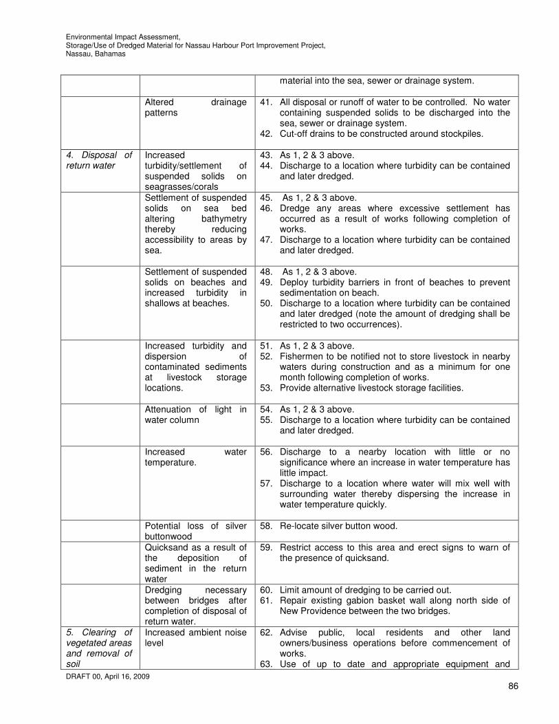
Environmental Impact Assessment, Storage/Use of Dredged Material for Nassau Harbour Port Improvement Project, Nassau, Bahamas
DRAFT 00, April 16, 2009
86
material into the sea, sewer or drainage system.
Altered drainage patterns
41. All disposal or runoff of water to be controlled. No water containing suspended solids to be discharged into the sea, sewer or drainage system.
42. Cut-off drains to be constructed around stockpiles.
4. Disposal of return water
Increased turbidity/settlement of suspended solids on seagrasses/corals
43. As 1, 2 & 3 above. 44. Discharge to a location where turbidity can be contained
and later dredged.
Settlement of suspended solids on sea bed altering bathymetry thereby reducing accessibility to areas by sea.
45. As 1, 2 & 3 above. 46. Dredge any areas where excessive settlement has
occurred as a result of works following completion of works.
47. Discharge to a location where turbidity can be contained and later dredged.
Settlement of suspended
solids on beaches and increased turbidity in shallows at beaches.
48. As 1, 2 & 3 above. 49. Deploy turbidity barriers in front of beaches to prevent
sedimentation on beach. 50. Discharge to a location where turbidity can be contained
and later dredged (note the amount of dredging shall be restricted to two occurrences).
Increased turbidity and
dispersion of contaminated sediments at livestock storage locations.
51. As 1, 2 & 3 above. 52. Fishermen to be notified not to store livestock in nearby
waters during construction and as a minimum for one month following completion of works.
53. Provide alternative livestock storage facilities.
Attenuation of light in water column
54. As 1, 2 & 3 above. 55. Discharge to a location where turbidity can be contained
and later dredged.
Increased water temperature.
56. Discharge to a nearby location with little or no significance where an increase in water temperature has little impact.
57. Discharge to a location where water will mix well with surrounding water thereby dispersing the increase in water temperature quickly.
Potential loss of silver
buttonwood 58. Re-locate silver button wood.
Quicksand as a result of the deposition of sediment in the return water
59. Restrict access to this area and erect signs to warn of the presence of quicksand.
Dredging necessary between bridges after completion of disposal of return water.
60. Limit amount of dredging to be carried out. 61. Repair existing gabion basket wall along north side of
New Providence between the two bridges.
5. Clearing of vegetated areas and removal of soil
Increased ambient noise level
62. Advise public, local residents and other land owners/business operations before commencement of works.
63. Use of up to date and appropriate equipment and
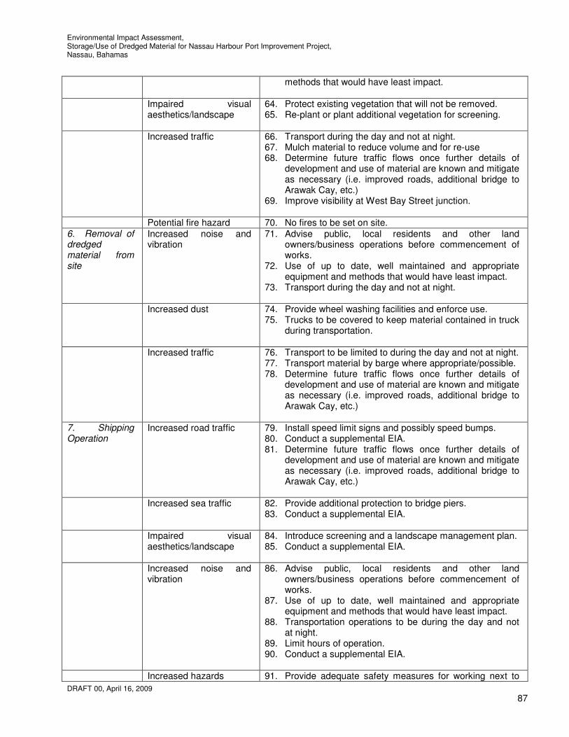
Environmental Impact Assessment, Storage/Use of Dredged Material for Nassau Harbour Port Improvement Project, Nassau, Bahamas
DRAFT 00, April 16, 2009
87
methods that would have least impact.
Impaired visual aesthetics/landscape
64. Protect existing vegetation that will not be removed. 65. Re-plant or plant additional vegetation for screening.
Increased traffic 66. Transport during the day and not at night. 67. Mulch material to reduce volume and for re-use 68. Determine future traffic flows once further details of
development and use of material are known and mitigate as necessary (i.e. improved roads, additional bridge to Arawak Cay, etc.)
69. Improve visibility at West Bay Street junction.
Potential fire hazard 70. No fires to be set on site. 6. Removal of dredged material from site
Increased noise and vibration
71. Advise public, local residents and other land owners/business operations before commencement of works.
72. Use of up to date, well maintained and appropriate equipment and methods that would have least impact.
73. Transport during the day and not at night.
Increased dust 74. Provide wheel washing facilities and enforce use. 75. Trucks to be covered to keep material contained in truck
during transportation.
Increased traffic 76. Transport to be limited to during the day and not at night. 77. Transport material by barge where appropriate/possible. 78. Determine future traffic flows once further details of
development and use of material are known and mitigate as necessary (i.e. improved roads, additional bridge to Arawak Cay, etc.)
7. Shipping Operation
Increased road traffic 79. Install speed limit signs and possibly speed bumps. 80. Conduct a supplemental EIA. 81. Determine future traffic flows once further details of
development and use of material are known and mitigate as necessary (i.e. improved roads, additional bridge to Arawak Cay, etc.)
Increased sea traffic 82. Provide additional protection to bridge piers.
83. Conduct a supplemental EIA.
Impaired visual aesthetics/landscape
84. Introduce screening and a landscape management plan. 85. Conduct a supplemental EIA.
Increased noise and vibration
86. Advise public, local residents and other land owners/business operations before commencement of works.
87. Use of up to date, well maintained and appropriate equipment and methods that would have least impact.
88. Transportation operations to be during the day and not at night.
89. Limit hours of operation. 90. Conduct a supplemental EIA.
Increased hazards 91. Provide adequate safety measures for working next to

Environmental Impact Assessment, Storage/Use of Dredged Material for Nassau Harbour Port Improvement Project, Nassau, Bahamas
DRAFT 00, April 16, 2009
88
open water safely (i.e.. buoyancy aids readily available for use in emergencies, etc.).
92. Provide spill containment kits for immediate usage in the event of a fuel spill.
93. Conduct a supplemental EIA.
Additional dredging to allow access to large vessels.
94. Same as 1, 2, and 3 above. 95. Conduct these activities at the earliest opportunity. 96. Conduct a supplemental EIA.
Deterioration of water quality
97. Place sign boards close to areas where sea vessels moor to educate users of the area of laws and good practice with regard to handling of waste, oil, fuels, biocides, etc.
98. Conduct a supplemental EIA.
Major costs associated with mitigation measures are as follows;
1. General • Public advisories
2. Control of suspended sediment dispersal
• Turbidity barrier purchase, deployment and maintenance • Turbidity monitoring exercises • Provision of livestock storage facilities. • Dredging of area between the two bridges between Arawak Cay and New Providence where
excessive settlement occurs as a result of the disposal of the return water. • Repair existing gabion basket wall along north side of New Providence between the two
bridges.
3. Land reclamation • Dredging to maintain access on the north side of the extension to a depth similar to that
existing. • Re-location of sea grass beds. • Removal of industrial waste/dumped equipment/vehicles/sunken vessels. • Install additional protection at bridge piers. • Provide lighting at extents of the extension for navigation purposes. • Repair damaged concrete bridge piers.
4. Storage of material
• Drainage and silt traps • Signage
5. Use of Material
• Determine future traffic flows once further details of development and use of material are known and mitigate as necessary (i.e. improved roads, additional bridge to Arawak Cay, etc.)
6. Use of reclaimed land
• To be determined following supplemental EIA

Environmental Impact Assessment, Storage/Use of Dredged Material for Nassau Harbour Port Improvement Project, Nassau, Bahamas
DRAFT 00, April 16, 2009
89
11. ENVIROMENTAL MANAGEMENT Continuous on-site supervision is to be provided by the Contractor’s dedicated personnel who will assist in directing day to day environmental management during construction and will be overseen by the Engineer's Representative (E.R.). The E.R. will be responsible for completion of the performance monitoring records (Fortnightly Environmental Monitoring Form a copy of which is included in Appendix C). There will therefore be ongoing discussion of Contractor practice and working methods in relation to well defined contractual obligations. Resolution of outstanding issues at completion, for example, in relation to environmental clean-up, waste disposal and site restoration, will be required before the contract is signed-off for final payment. Experience suggests that good two-way communication and on-site supervision as proposed will create the conditions for positive and successful environmental management. It is the obligation of the Contractor to comply with all the requirements and stipulations listed below. Section 1 covers the most important general topics of environmental concern. Section 2 covers these areas in generic checklist format and Section 3 focuses on site management requirements. The project Fortnightly Environmental Monitoring Form covers all these issues. It will be completed by the E.R. and it is the requirement of the Contractor to countersign these forms. 8.1 Contractor Environmental Management Requirements
The Environmental Requirements binding on Contractors are comprehensive stipulations on Contractor environmental practice, including health and safety requirements. These requirements highlight particular issues. 8.1.1 Site Safety and Health The Contractor shall be required to appoint a designated Site Safety Officer with an acting safety officer always appointed in his absence. Basic first aid training of these persons shall be required, for which the Basic Life Support Course at the Doctor’s Hospital is recommended. There shall be a fully equipped First Aid Box at all work sites at all times and a list of emergency telephone numbers in case of accident. Minor and major accidents shall be recorded in an accident log book. Personal protective equipment (PPE) shall be worn in areas designated for their use. When working alongside or over water, where there is a risk of drowning, the Contractor shall take appropriate measures to prevent falling (e.g. use of harnesses) and rescue equipment shall be readily to hand (e.g. use of life jackets, life lines/rings and a safety boat). Work shall be halted in dangerous weather conditions or sea states. At all times work sites shall be maintained in an orderly, safe and tidy state. Precautions against fire accident shall be taken and appropriate fire safety equipment supplied and clearly indicated at work sites The Contractor shall, as required, arrange for safe road use while adjacent construction activities (e.g. stockpiling) are in progress and impeding the highway. Construction zone signage shall be in place for each works operation. Hazardous areas such as excavations will be delineated with construction cones (with lighting where instructed by the E.R.). This shall include but not be limited to the following: temporary works; pre-stressing/post-tensioning works; pile driving; batching plants/crushers; working near water; working at height; working in confined spaces; interaction with the general public, especially road users and adjacent property owners/occupiers and traffic management. The Contractor’s Safety Officer will inspect sites for compliance with approved working methods and these contractual requirements under the oversight of the E.R. Government of Bahamas labour laws and occupational health and safety policies shall be applied at all times.
Environmental Impact Assessment, Storage/Use of Dredged Material for Nassau Harbour Port Improvement Project, Nassau, Bahamas
DRAFT 00, April 16, 2009
90
8.1.2. Construction Traffic The Contractor’s arrangements for managing construction traffic will be continually reviewed. Local communities will be forewarned of any unavoidable temporary restriction to traffic access. The Contractor will make arrangements where instructed by the E.R. for plant wheel washing to ensure that mud is not deposited onto public highways. The Engineer’s Representative (E.R.) will be alerted to the possibility of construction traffic causing pavement and structure damage due to overloading, increase in congestion and any road safety hazards. Care shall be taken to minimise damage to pavement being saved. The Contractor will be responsible for any damages caused to the roadway by poorly maintained or overloaded equipment. Use of tracked equipment will be limited to areas adjacent to sheet piling construction 8.1.3 Noise and Dust Nuisance The level of noise and dust from construction plant operation shall be periodically assessed by the Contractor and the E.R. in relation to the significance of potential disturbance. The Contractor will maintain equipment in good order so as to minimise extraneous noise. The general rule shall be that construction operations shall be restricted to daylight hours between 7.00 am and 7.00 pm. Where there is a reason to work outside these hours to speed up the progress of works, local communities will be given advance notice and specific requests will be reasonably accommodated. Any complaints from local communities concerning noise (or dust) shall be reported to the E.R. and steps taken wherever possible to conform to local wishes, for instance in relation to the specific timing of activities. 8.1.4 Piling, disposal of return water and dredging The Contractor will be required to use turbidity barriers around the piling works, return water disposal site and dredging sites while undertaking these activities. The turbidity level is to be measured at the specified monitoring stations and reported. The dredge pipeline must be respected so that there is no risk of damage to the marine environment as a result of spillage. The method of construction of the extension to Arawak Cay is to be carried out so as to cause minimal impact to the marine environment. 8.1.5 Construction Material Sources Whilst it is not proposed to use borrow sites and quarries for extraction of fill, aggregate, rock and other materials, if necessary, any borrow site will be specified for approved use by the Consultant or E.R. and be legally sanctioned. Any new sites to be opened will require the appropriate permitting application and approval from the Department of Physical Planning. 8.1.6 Natural Resources Management The Contractor is required at all times to be vigilant with respect to conservation of wildlife and natural habitat. Trees and vegetation will not be disturbed unless necessary to complete the project works. Top soils will be retained for subsequent restoration works. Also see 8.1.4 above. The Contractor is responsible for the activities of his staff and will require them at all times to show due respect for the natural environment and its conservation. 8.1.7 Water Abstraction The Contractor will be required to make suitable arrangements for his own supply of water and, as necessary, to provide an alternative supply to any users affected by his water abstraction. The location of wells dug for water supply will conform to local permitting arrangements and in no circumstances shall he allow his abstraction requirements to affect the quality of freshwater lenses on the island or have any other deleterious effect on natural resources.
Environmental Impact Assessment, Storage/Use of Dredged Material for Nassau Harbour Port Improvement Project, Nassau, Bahamas
DRAFT 00, April 16, 2009
91
8.1.8 Erosion and Pollution of Wetlands and Watercourses Measures will be taken to minimise erosion and sedimentation in borrow pits, facilities yards and work sites. Silt traps and cut-off drains around yards will be incorporated into site works to restrict runoff wash and transport of sediments, reducing the potential for pollution of adjacent land from any local sources of contamination. The Contractor shall ensure that pollution of the shoreline, wetlands and watercourses does not occur. Pollution of coastal areas, wetlands, groundwater and surface water arising from fuel and oil spillages, sanitary and other wastes is a potential impact for which appropriate mitigation measures should be included in the Contractor’s methods of working. The Contractor will be required to pay all costs associated with clearing up any pollution caused by his activities and to pay full compensation to those affected. See 8.1.4 above. Silt-traps and turbidity barriers shall be provided by the Contractor and managed to the approval of the E.R. 8.1.9 Disposal of Waste Materials The Contractor shall remove all existing industrial waste and abandoned/sunken vessels/vehicles as indicated above. The Contractor shall make provision for the safe and legal disposal of all wastes and prevention of any spillages, leakage of polluting materials etc. The disposal of materials by the Contractor within the site boundary and at off-site locations shall require the E.R.’s approval. Special arrangements shall be made for proper disposal of scrap materials, waste oils and any other potentially hazardous materials in compliance with the regulations of the Department of Environmental Health. The Department of Environmental Health should be consulted as and whenever appropriate. 8.1.10 Works Site Restoration Upon completion of implementation of project works, the Contractor shall restore all work sites, borrow sites (and any other land occupied or used by the Contractor during the course of the project) to the approval of the E.R. In particular his obligations shall include the requirement to: a) restore borrow sites with conserved top soil, to the approval of the E.R. and local landowners. The Contractor shall obtain a written release from each affected landowner; b) re-shape embankments and re-establish vegetation in restored areas according to original method statements or as otherwise indicated by the E.R. using locally prevalent non-invasive species to provide cover against erosion from rainwater; c) clean-up of all construction sites, work areas and any facilities installed by the Contractor. 8.1.11 Consultation and Legal Requirements The Contractor shall co-operate, as required, with local government administrations and the MOW, and staff of the Bahamas Environment Science and Technology Commission (BEST). It is the responsibility of the Contractor to ensure compliance at all times with existing and new government regulations, including all statutory licensing and permitting requirements. National Laws and Regulations
The project will be designed, constructed, operated, and maintained in accordance with applicable Bahamian environmental laws and regulation, including the following;
Environmental Impact Assessment, Storage/Use of Dredged Material for Nassau Harbour Port Improvement Project, Nassau, Bahamas
DRAFT 00, April 16, 2009
92
The Environmental Health Act The Conservation and Protection of the Physical Environment of the Bahamas Act The Antiquities, Monuments, and Museums Act The Public Works Act The Wild Birds and Plants Protection Acts The Bahamas National Trust Act The Fisheries Resources Act The Coast Protection Act The Water and Sewerage Act The Bahamas National Wetlands Policy 2007; and The National Invasive Species Strategy for the Bahamas.
The Contractor shall conform to all these and other current legislation, including updated health and safety regulations. Prior to the commencement of construction activities local communities will be informed of the implementation schedule for contracted works and local requests incorporated as reasonable, where at no extra cost, subject to approval by the E.R. 8.2. Checklist of Environmental Stipulations At all times Contractors shall be required to conform with the following particular stipulations in implementing construction works: (a) there shall be clear demarcation of the extent of Contractor’s work site(s) including areas for material storage, working yard (e.g. block casting), plant storage. (b) health and safety equipment (including protective clothing and boots) shall be available and in use at work sites and construction facilities/camps. First aid boxes will be mandatory at all sites. (c) fuel storage sites shall be bunded by a small berm to confine and mitigate the effects of spillage. The capacity of the confined area to be 110% of volume of fuel stored and protected from rainwater. (d) discharge of dust and fumes shall be minimised and there will be no burning of toxic substances. (e) noise abatement on construction sites shall minimise avoidable inconvenience to local populations. (f) dump trucks shall be equipped with tarpaulins or similar devices to prevent material spillage and roads will be kept clean of mud and construction debris. (g) the method of construction shall minimise the length of coastal site works opened up at any one time as much as is considered feasible to minimise any avoidable impacts on water quality. (h) there will be no disposal of non-biodegradable materials on site without the express permission of the E.R. or local authorities. Oil collection traps will be in use in workshop areas. (i) there shall be no removal of sand or dredged material without an official mining permit and written approval of the E.R. (j) used oils shall be containerised and transported to an approved local agent for safe disposal or transported with other scrap equipment to an approved facility elsewhere. (k) no disposal of material in environmentally sensitive areas, e.g. mangroves, marshes, protected vegetation, and the marine environment. (l) the Contractor shall remove all construction equipment and scrap waste from his sites on completion. 8.3. Contractor Facilities, Plant and Operations

Environmental Impact Assessment, Storage/Use of Dredged Material for Nassau Harbour Port Improvement Project, Nassau, Bahamas
DRAFT 00, April 16, 2009
93
Any facilities installed by the Contractor for the purpose of conducting construction works should meet appropriate standards of responsible environmental management and safety practice. Contractors will be required to present general Method Statements to show how they will implement construction plans to achieve: 1) legally approved and environmentally acceptable extraction of materials from borrow pits with proper restoration. 2) minimal clearance of natural vegetation and interference with natural drainage flows, avoidance of any significant degradation of freshwater lenses. 3) environmentally sensitive location of temporary construction yard sites and space for plant and materials storage. 4) safe location and protection of fuel facilities, safe storage of hydrocarbons and other chemicals, re-use/disposal of used oil at approved sites, including a Fire Plan. 5) adequate facilities for collection and treatment of wastewater (as required), storage and legally disposal of general construction waste, solid waste, chemicals etc. 6) appropriately restored and unencumbered work sites, yards, camps and other facilities at project completion. 8.4 Site Considerations
Consistent application of codes of good environmental practice (Environmental Requirements) and effective supervision will be the major influence on the potential for environmental impact (positive and negative) and associated health and safety risks from the project. There will be a requirement for a Contractor materials storage area and temporary site facilities. A preferred area will be proposed by the Contractor and subject to approval by the Engineer’s Representative. There are no areas where there could be serious long term environmental impacts from a visual or ecological perspective provided restoration of the site is properly supervised. The Contractor must be required to obtain all the necessary local permits for his yards and materials needs from local borrow areas. 8.5 Environmental Awareness and Contractor Supervision
The standard practice for the Contractor to present his proposed work methods for approval by the E.R. must be respected. The E.R. will make a judgment on what practical environmental improvements are required. The E.R. shall be on site at sensitive moments to ensure works are being carried with due regard for the environment and in concordance with the Environmental Requirements and Environmental Management Plan (EMP). 8.6 Environmental Management Plan (EMP) The environmental monitoring plan (EMP) is presented in Appendix D in outline form. It should be detailed and completed when the project action plan has been determined. The purpose of the EMP is to monitor or control the environmental effects of the storage and use of the material process. It should be based on compliance, verification, feedback, and know-how. It is therefore suggested that the Contractor carries out the EMP. The EMP should be able to provide responses to the following three questions:
i) Why is monitoring being conducted? ii) What specifically is being carried out?

Environmental Impact Assessment, Storage/Use of Dredged Material for Nassau Harbour Port Improvement Project, Nassau, Bahamas
DRAFT 00, April 16, 2009
94
iii) How are the data and information to be used in planning and decision-making? In the case of the proposed stockpiling and reclamation works, environmental monitoring is particularly necessary to ensure that suspended sediments generated during piling, dredging and during disposal of the dredged materials, do not adversely affect the health of the coastal ecosystems around Arawak Cay and elsewhere along the coast. This could be achieved by:
1. ensuring that the deliberate disturbance of bottom sediments during piling work and the deposition of fill material at the extension are done technically in a manner that minimises the amount and extent of fugitive sediment suspension (i.e. effective deployment of turbidity barriers and deposition of fill material in areas already protected by piling);
2. ensuring that the fine sediments in waters to be disposed of are only released at the containment location and the water disposed of only after adequate settlement into waters further protected by turbidity barriers.
3. ensuring that the deliberate disturbance and removal of bottom sediments during dredging are done technically in a manner that minimises the degree and extent of fugitive sediment suspension (i.e. appropriate dredge type and operational procedures).
4. ensuring that noise, vibration, odour and dust are kept to an acceptable level.
The monitoring programme should therefore focus on; 1. use of appropriate equipment for the project; 2. confinement of work to the specified storage areas; 3. monitoring of water quality including frequent measurements of water turbidity at the specified
monitoring stations; 4. monitoring of beach profiles. 5. monitoring of noise, vibration, odour and dust. 6. monitoring of accidents
The turbidity compliance standards are set out above. The standards set take into account normal prevailing water quality conditions, the duration of the extension of Arawak Cay works and the value of marine resources. The results of the turbidity measurements, which should be taken independently, should immediately be recorded formally and made available to the Engineers Representative so that any corrections and adjustments to operations can be made quickly. The Engineers Representative must have the authority to halt operations should this become necessary to protect the reef ecosystems at risk. Data has and continues to be collected for the 2008 WSSS Practicum/UEP Field Project ‘Integrated Assessment of Impacts of Stormwater in Coastal Zone of Nassau, New Providence, The Bahamas’ by the College of the Bahamas and other entities. It is recommended that monitoring be carried out in tandem with this work where relevant.
12. EMERGENCY CONTINGENCY PLAN In an environmental context, the critical emergency situation that could arise during the proposed extension of Arawak Cay works is the collision between the pile driving vessel and another ship, resulting in the significant release of oil. In that event, reference should be made to the national oil spill response procedures. Adequate oil spill containment equipment should be available for immediate deployment at or near the project site during the extension of Arawak Cay works. Major spills should immediately be reported to the Bahamas Defense Force if in Country and Port Authority. An emergency contingency plan for severe weather conditions such as storms and hurricanes will also be necessary to ensure equipment and material are adequately secured. Emergency contact numbers should be made available to the Contractor.

Environmental Impact Assessment, Storage/Use of Dredged Material for Nassau Harbour Port Improvement Project, Nassau, Bahamas
DRAFT 00, April 16, 2009
95
13. CONCLUSIONS AND RECOMMENDATIONS
10.1 Overview
This EIA has been carried out on the basis that it is necessary to carry out dredging at Nassau Harbour to increase the capacity of the harbour and its approach channel to accommodate larger cruise ship vessels Initially there will be in this project a considerable requirement for clean up of the site which is covered in vegetation and has been used to dump vehicles, machinery and oil drums among other industrial debris and litter as well as the removal of sunken vessels. The impact of construction and use of the stockpile areas will have a significant effect, more so during the construction. Ecological effects will be dependant on the ability of the Contractor to limit the areas affected by turbidity and the levels of turbidity and the success of the re-location of sea grass beds, corals and sponges. The project on the whole will have considerable local planning and tourism advantages. 10.2 Main Findings The relief to congestion of the existing downtown area of Nassau itself is a major advantage of the project. The opportunity for developing the old town area to enhance its amenity and visual advantages for recreational and non-commercial usage should be taken. The EMP requirements for this project cover land reclamation, material stockpiling, disposal of return water, dredging and waste removal and clean-up. Environmental supervision and monitoring during construction must include health and safety considerations and mitigation of avoidable marine impact. Because the proposed site is degraded and abused as an illegal disposal site there is opportunity for improvement and landscaping and this needs to be properly managed. The site and general Contractor environmental requirements in this EIA and associated EMP should give assurance that there will be effective site environmental management and safety practice. The guidelines adopted cover all aspects of materials sourcing, movement and storage. In summary, provided there is proper implementation of this EIA and the EMP and there is adequate site supervision, assured by the presence of the Engineer’s Representative, the level of social disbenefits and environmental consequences during construction should be tolerable. There is limited residential habitation near to the site so noise and dust are not major issues. Once turbidity curtains are deployed effectively, water quality standards maintained and sea grasses and corals re-located effectively there should be minimal impact on marine habitat. Once an amicable alternative location is provided for the storage of livestock for fishermen there should be minimal impact on fishing . It will be necessary to carry out additional dredging to that in Nassau Harbour to maintain access by boat south of Silver Cay and to restore the area between Arawak Cay and New Providence where the return water is to be disposed. Traffic can be maintained without disruption along the existing West Bay Street once a schedule for transport of the dredged material for use on the future projects is well planned. The main conclusions arising from the EIA study are:
1. The total amount of dredged material to be stored at Arawak Cay is estimated at 2.0 million cubic yards which will require the extension of Arawak Cay approximately 1000 feet to the west. This material is predominantly hard limestone material with some overlay of sands and does not contain any significant levels of metal contaminants.
2. The main potential impacts of the proposed storage of the dredged material and the extension to Arawak Cay works that have been identified are:
a. the extension of Arawak Cay will result in the loss of 32 acres of sea bed. b. suspension of fine sediments in the water column during piling, construction, water
disposal and dredging will result in deleterious turbidity and sedimentation over seagrass communities and corals causing impacts on some of the biota.
c. modified wave and current magnitudes and patterns (generally waves increase with slight shifts in direction). There are expected to be minor changes to the beach profile. These are not considered to be significant.
Environmental Impact Assessment, Storage/Use of Dredged Material for Nassau Harbour Port Improvement Project, Nassau, Bahamas
DRAFT 00, April 16, 2009
96
d. Decreased channel widths and depths north and south of Arawak Cay and increased lengths.
e. increased ambient noise level. f. Impaired aesthetics/landscape. g. fishing areas currently used by fishermen will not be adversely affected by the work since
the work will not be carried out in traditional fishing grounds, and any dispersal of suspended sediments should not extend to traditional fishing grounds. The work may however affect water quality at locations where fishermen store their livestock.
3. Satisfactory mitigation of these impacts identified above can be achieved by: a. properly controlled extension of Arawak Cay operations and restriction to designated
extension of Arawak Cay sites to minimise sediment suspension; b. deployment of turbidity barriers around the works areas in the marine environment where
currents are less than 1.5 ft/s as well as along the shallows of Saunders Beach to prevent movement of any suspended sediments near or on the beach.
c. Re-location of sea grasses, sponges and corals d. co-ordinate activities with the Port Authority and other relevant government agencies. e. The edges of the channel to be dredged at an angle as determined by the geotechnical
engineer that will provide a stable edge. f. employ appropriate water quality and beach monitoring techniques starting before
construction activities. g. Public advisories h. Provision of livestock storage facilities. i. dredging of area between the two bridges between Arawak Cay and New Providence
where excessive settlement occurs as a result of the disposal of the return water. j. dredging to maintain access on the north side of the extension to a depth similar to that
existing. k. removal of industrial waste/dumped equipment/vehicles/sunken vessels. l. install additional protection at bridge piers. m. provide lighting at extents of the extension for navigation purposes.
10.3 Project Abandonment
The discontinuation of the project whilst considered very unlikely should be considered as there are a variety of reasons that could require project abandonment. Abandonment during the early stages (i.e. before the arrival of the dredger) would result in some environmental impacts for the areas for stockpiling as these areas will need to be cleared and an alternative access road constructed. There could also be other significant impacts as the proposed project involves a requirement for re-locating sea grass beds, sponges and corals at the proposed extension. Abandonment during the dredging operational stage requires the project proponent to consider plans for the removal or disposal of temporary structures and facilities and possibly an alternative site for storing the dredged material. Abandonment plans need to be addressed. 10.4 Recommendations
1. Hold co-ordination meetings with the consulting engineers, the dredging contractors, MOW, BEST, Department of Fisheries and EHS before and during the dredging activities.
2. Data has and continues to be collected for the 2008 WSSS Practicum/UEP Field Project ‘Integrated Assessment of Impacts of Stormwater in Coastal Zone of Nassau, New Providence, The Bahamas’. It is recommended that monitoring be carried out in tandem with this work being carried out where relevant.
3. For the disposal process predictive tests/modeling is recommended to determine the extent of
suspended sediment levels and amount of sediment deposition likely at the disposal area.

Environmental Impact Assessment, Storage/Use of Dredged Material for Nassau Harbour Port Improvement Project, Nassau, Bahamas
DRAFT 00, April 16, 2009
97
4. For the future use of the expanded Arawak Cay area as a shipping area it is recommended that a
supplemental EIA is carried out once plans for the development have been developed.
5. Heightened levels of mercury have been detected near the West Bay Street Jetty drain. It is recommended that tests be carried out on the return at this drain to determine if mercury continues to be deposited at this location.
6. Shoreline monitoring is recommended for the beaches at Saunders Beach and on the south side of
Silver Cay.
11. REFERENCES Blue Engineering, 20 November 2008, “Dredging Nassau Harbour Port Improvement Project”, Draft Report W. F. Baird & Associates Ltd., January 13 2009 “Currents in Nassau Harbour, Nassau Harbour Port Improvement Project”, Draft Report W. F. Baird & Associates Ltd., January 27 2009 “Arawak Cay Extension Impacts at Saunders Beach, Nassau Harbour Port Improvement Project”, Draft Report Trow International Inc., October 28, 2008 “Geotechnical Investigation, Arawak Cay Extension, Nassau Harbour Port Improvement Project” Trow International Inc., August 7, 2008 “Geotechnical Investigation, Part 1, Dredging Nassau Harbour Port Improvement Project” Cox & SHAL Consultants, Preliminary Engineering Report U.S.A.C.E., September 2005 “Turbidity barriers as a Dredging Project Management Practice”, (ERDC TN-DOER-E21) U.S.A.C.E., March 1983 “Dredging and Dredged Material Disposal”, (EM 1110-2-5025) U.S.A.C.E., June 1987 “Beneficial Uses of Dredged Material”, (EM 1110-2-5026) U.S.A.C.E., September 1987 “Confined Disposal of Dredged Material”, (EM 1110-2-5027) Bahamas Department of Meteorology. Climate of the Bahamas. [Internet]. 2008. Nassau, Bahamas. http://www.bahamasweather.org.bs/climate/general climate/. Accessed December 2008. Bahamas Environment, Science and Technology Commission (BEST). 1999. The Commonwealth of the Bahamas: National Biodiversity Strategy and Action Plan. The Bahamas: Bahamas Environment Science and Technology Commission. BEST. 2000. Workshop notes. Marine Conservation and Research Workshop: College of The Bahamas, August 16, 2000. The Bahamas: Bahamas Environment Science and Technology Commission. Available online: http://www.best.bs/climate/pdf/MCR_Summary.pdf. Accessed December 2008. BEST. 2002. Bahamas Environmental Handbook. The Bahamas: Bahamas Environment Science and Technology Commission. Bahamas National Trust. Endangered Species of The Bahamas. [Internet]. 2005. Nassau, The Bahamas. http://www.bahamas.gov.bs/bahamasweb2/home.nsf/vContentW/E9EEA06FFD9904E506256F010071F8F
Environmental Impact Assessment, Storage/Use of Dredged Material for Nassau Harbour Port Improvement Project, Nassau, Bahamas
DRAFT 00, April 16, 2009
98
0!OpenDocument&Highlight=0,endangered%20species Accessed December 11, 2008. Bahamas Reef Environmental Educational Foundation (BREEF). Status of Bahamian Fisheries. [Internet]. 2006. Nassau, The Bahamas. http://www.breef.org/OurMarineResources/tabid/54/Default.aspx. Accessed December 22, 2008. Bahamas Water & Sewerage Corporation (WSC). New Providence Water. [Internet]. 2005. Nassau, The Bahamas. http://www.wsc.com.bs/NPwater.asp. Accessed December 17, 2008. Birds of north America Online. [Internet]. 2007. Ithaca, New York. http://bna.birds.cornell.edu/bn Accessed December 3, 2008. Caribbean Regional Fisheries Mechanism (CRFM). Bahamas Fisheries Summary. [Internet]. 2007. Belize City, Belize. http://www.caricom-fisheries.com/members/bahamas.asp Accessed December 12, 2008. Currie, D., J. Wunderle, D. Ewert, and E. Carey. 2003. The most elusive bird in the Bahamas? World Birdwatch 25(4): 13-15. Available online: http://www.birdlife.org/news/features/2004/01/kirtlands.html. Accessed December 27, 2008. Department of Statistics. Statistics: Population Census and Growth Rates. [Internet]. 2005b. Nassau, The Bahamas. http://www.bahamas.gov.bs/bahamasweb2/home.nsf/vContentW/9C7DE759B4AEFBEA06256ED10071AF 8C. Accessed December 13, 2008. Department of Statistics. 2007. The Commonwealth of The Bahamas: National Accounts 2006. The Bahamas; Ministry of Finance, Department of Statistics. Available online: http://www.centralbankbahamas.com/download/071899500.pdf. Accessed January 6, 2009. Etienne Dupuch Jr. Publications Ltd. 2006. Bahamas Handbook. The Bahamas: Etienne Dupuch Jr. Publications Ltd. Fish in The Bahamas. Bahamas Fishing Laws & Regulations. [Internet]. 2007. http://fishinthebahamas.com/bahamas-fishing-regulations.html. Accessed December 19, 2008. FishBase. Species summaries. [Internet]. 2007. Kiel, Germany. http://www.fishbase.org. Accessed December 18, 2007.http://lwf.ncdc.noaa.gov/oa/climate/research/2003/fl-hu-is-comp.html. Accessed December 19, 2008. NOAA Coastal Services Center. Historical Hurricane Tracks. [Internet]. 2006. Charlestown, South Carolina. http://maps.csc.noaa.gov/hurricanes/viewer.html. Accessed December 12, 2008. NOAA. 2007a. Tides & Currents Pro Version 3.0. Nobeltec Nautical Software. east Central America, Bahamas. NOAA. National Data Buoy Center: Station 41046 - E Bahamas. [Internet]. 2007b. Stennis Space Center, Mississippi. http://www.ndbc.noaa.gov/station_page.php?station=41046. http://www.ndbc.noaa.gov/station_page.php?station=spgf1 Accessed December 20, 2008. Reef Environmental Education Foundation (REEF). Geographic Zone Report 4201: New Providence. [Internet].2007. Key Largo, Florida. http://www.reef.org/db/reports/geo/TWA/4201.Accessed January 17, 2009. Sealey, K.S., B. Brunnick, S. Harzen, C. Luton, V. Nero, and L. Flowers. 2002. An Ecoregional Plan for the Bahamian Archipelago. Jupiter, Florida: Taras Oceanographic Foundation. Available online: http://henge.bio.miami.edu/coastalecology/BEP%20Final%20Report%20PDF.pdf. Accessed January 16, 2009. Hluchan, T. 2008. Personal communication.

Environmental Impact Assessment, Storage/Use of Dredged Material for Nassau Harbour Port Improvement Project, Nassau, Bahamas
DRAFT 00, April 16, 2009
99
Allens, Capt. A.. 2008. Personal communication. Cant, S.. 2008. Personal communication. Sealey, Dr. K.. 2008. Personal communication.
12. APPENDICES Appendix A. Photographs Appendix B. Turbidity Monitoring Forms Appendix C. Fortnightly Environmental Monitoring Form Appendix D. Environmental Management Plan Outline.

Environmental Impact Assessment, Storage/Use of Dredged Material for Nassau Harbour Port Improvement Project, Nassau, Bahamas
Appendix A.
Photographs

Environmental Impact Assessment, Storage/Use of Dredged Material for Nassau Harbour Port Improvement Project, Nassau, Bahamas
Appendix B.
Turbidity Monitoring Forms

Environmental Impact Assessment, Storage/Use of Dredged Material for Nassau Harbour Port Improvement Project, Nassau, Bahamas
Appendix C.
Fortnightly Environmental Monitoring Form

Environmental Impact Assessment, Storage/Use of Dredged Material for Nassau Harbour Port Improvement Project, Nassau, Bahamas
Appendix D.
Environmental Management Plan Outline