Embed Size (px)
Citation preview
Environmental Impact Assessment Screening Report
Application to Drill a Vertical Core Well Land adjacent to Bramleymoor Lane, near
Marsh Lane
PEDL 300
January 2017
Contents
1. Introduction ..................................................................... 1
1.1 Requirement for EIA ............................................................................. 1
2. Site and Proposed Development ................................... 2
2.1 Site Context ........................................................................................... 2
3. Screening Assessment ................................................... 7
3.1 Introduction ........................................................................................... 7
3.2 Schedule 1 Projects .............................................................................. 7
3.3 Schedule 2 Projects .............................................................................. 7
3.4 Schedule 3 ............................................................................................. 8
3.5 Consideration of Cumulative Effects .................................................. 9
3.6 Planning Practice Guidance ................................................................ 9
3.7 Review of Screening Criteria ............................................................. 10
4. Conclusion ..................................................................... 19
Appendix 1 - Site Location Plan
Appendix 2 - Designation Plan
1
1. Introduction This report has been prepared in support of a request to Derbyshire County Council (“DCC”) to adopt a screening opinion to determine whether INEOS Upstream Limited's (“INEOS”) application for a temporary planning permission to drill a vertical core well to explore for shale gas ("Proposed Development") on land adjacent to Bramleymoor Lane, located approximately 0.5 km to the southwest of the settlement of Marsh Lane, Derbyshire ("site") constitutes Environmental Impact Assessment (EIA) development. DCC is the Mineral Planning Authority ("MPA") for the site. This report reflects the requirements of the Town and Country Planning (Environmental Impact Assessment) Regulations 20111 as amended (“EIA Regulations”) and in accordance with Regulation 5 of the EIA Regulations, this report contains:
• A plan sufficient to identify the land; • A brief description of the nature and purpose of the development and of its
possible effects on the environment; and • Other information the applicant wishes to provide.
1.1 Requirement for EIA
In order to determine whether the Proposed Development is ‘EIA development’, regard must be had to the EIA Regulations and supporting Planning Practice Guidance (“PPG”)2.
EIA development falls into two Schedules of the EIA Regulations. EIA is mandatory for developments listed within Schedule 1. Schedule 2 developments require EIA if they would be "likely to have significant effects on the environment by virtue of factors such as its nature, size or location". In deciding whether a Schedule 2 development is EIA development, Regulation 4(6) states:
“Where a local planning authority … has to decide under these Regulations whether Schedule 2 development is EIA development the authority … shall take into account in making that decision such of the selection criteria set out in Schedule 3 as are relevant to the development.”
In order to allow the MPA to determine the need for EIA, this report provides a description of the site and Proposed Development, a review of the EIA screening criteria based on the EIA Regulations and the PPG, a completed EIA Screening Checklist, a site location plan in Appendix 1, and a designation plan in Appendix 2.
1 SI 2011/1824 as amended by the Town and Country Planning (Environmental Impact Assessment) (Amendment) Regulations 2015 (No. 660) 2 DCLG, 2015, online access: http://planningguidance.planningportal.gov.uk/blog/guidance/environmental-impact-assessment/
2
2. Site and Proposed Development
2.1 Site Context
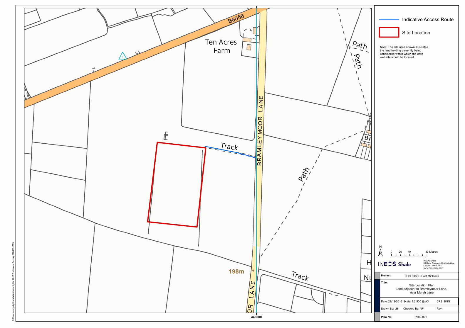
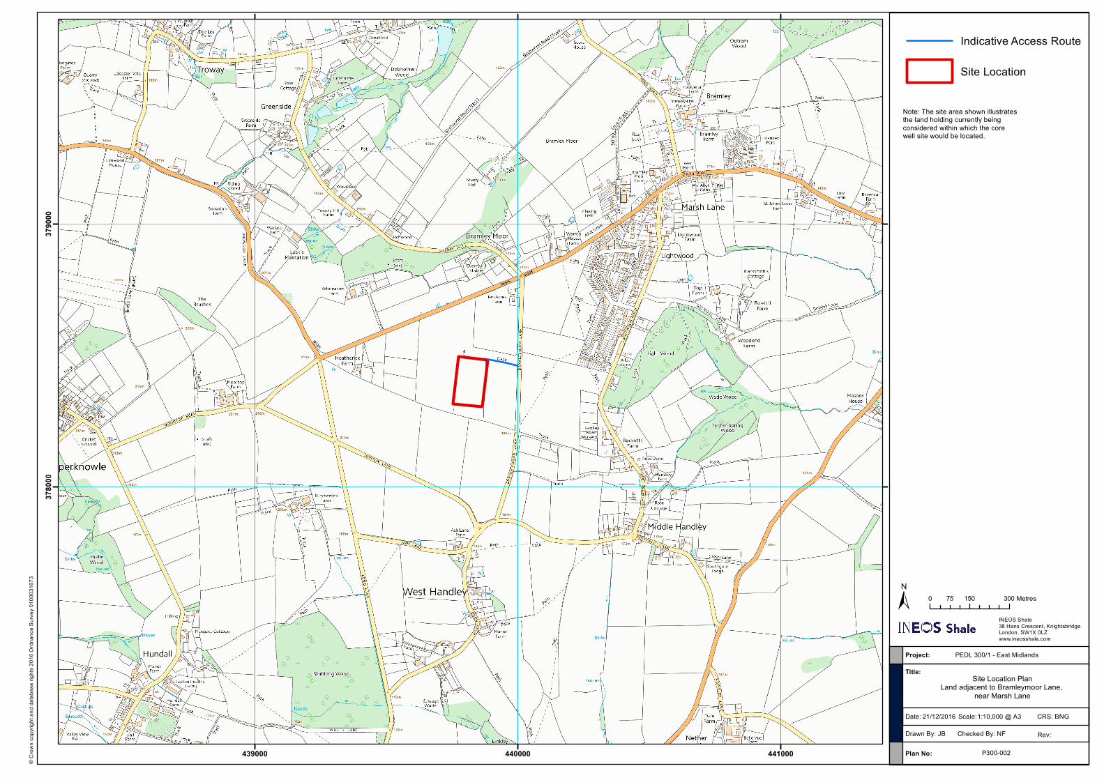
2.1.1 Site Description It is currently anticipated that the core well site would be less than 1 hectare (the access track to the nearest adopted road would be in addition to this). The site location plan presented in Appendix 1 illustrates the land holding currently being considered within which the core well site would be located. The proposed site access from the public highway is also illustrated in the plan.
2.1.2 Proposed Development
The Proposed Development will comprise five phases: Stage 1: Site Development and Establishment – approximately 3 months Stage 2: Drilling and Coring – approximately 3 months Stage 3: Establishment as Listening Well and Suspension – approximately 1 week with
the suspended well in place until restoration Stage 4: Undertaking Listening Well Operations – up to 3 weeks as required Stage 5: Abandonment and Restoration – approximately 1 month The overall duration of the Proposed Development would be a maximum of five years which accords with the length of INEOS’ initial Petroleum Exploration and Development Licence ("PEDL") term, as awarded by the Oil and Gas Authority. After five years the site will be restored to its existing condition. Stage 1 – Site Development and Establishment Activities during Stage 1 would include:
• Mobilisation: Any necessary pre-commencement surveys would be undertaken, including geotechnical surveys, site investigation surveys, road condition surveys and environmental surveys. The construction plant, including generators, site offices, welfare cabins and stores would be brought to site and site personnel would be inducted. The construction compound would be fenced for security and to delineate the proposals.
• Access tracks: The junction to the adopted road would be created/ improved ensuring that visibility splays provide safe access and egress from the site and any necessary passing places are installed. The access track would be lined with a geotextile membrane and covered with aggregate to prevent damage to the underlying soil during site construction and subsequent site works. An area for parking on the site would also be developed to ensure all necessary vehicles were within the site boundary.
• Site Clearance: The main site compound would cover approximately 99 m x
91 m. Vegetation would be carefully removed from the site and hedges trimmed subject to any ecological considerations relating to timing and method of working. The topsoil would be removed (approximately top 300 mm) and any subsoil necessary to create a level site surface. Screening bunds would be created within the perimeter of the site (approximately 2 m high) ensuring appropriate storage of this soil for restoration of the site and to act as visual and noise screening. The
3
site hardstanding area (approximately 25 m x 17 m) would be excavated within the central site area.
• Site Development and Lining: A liner anchor trench would be excavated at the foot of the topsoil bund. Geotextile and high density polyethylene (HDPE) liners would be laid over this area by licensed contractors to ensure an impermeable site lining, preventing any potential spills or surface water from percolating through the site floor into the underlying soil. These liners would be anchored in place by backfilling the trench, and the integrity of the liner tested. Any subsequent perforations of the liner (for example drilling of boreholes) would be heat sealed to the surrounding material (borehole casing). The liner would be covered by sub-base and aggregate to at least 450 mm below the finished site surface.
• Development of drainage: A perimeter water storage pipe (900 mm) would be
laid within a ditch at the foot of the topsoil bunds, feeding to a sump. A series of 150 mm drainage pipes would feed into this perimeter pipe from across the site. All surface runoff from the site would therefore be retained on the site and removed by a licensed waste contractor. Drainage from the central rig bund would feed into a separate bunded tank for removal and treatment.
• Development of site accommodation: Cabins would be placed on the perimeter
of the site, over the top of the perimeter water storage pipe trench. These would be stacked up to 2 cabins high to provide further screening as appropriate.
• Installation of monitoring boreholes: Groundwater monitoring boreholes would
be installed towards the edge of the site, in locations and to depths to be agreed with the Environment Agency. These would be installed under permitted development rights and do not form part of this planning application.
• Construction of Well Cellar: A well cellar would be excavated to form a
containment area from which the well would be drilled. This is constructed from a reinforced concrete ring approximately 2.5 m diameter and 3 m deep. The impermeable membrane would be incorporated into the cellar construction to maintain the integrity of the site. A conductor would be set in the top section of the well bore and cemented in place using a conductor installation rig (<10 m high) drilling with a mixture of air and water. Drill cuttings from the conductor installation would be removed from site.
• Demobilisation: The soil bunds would be covered with a grass seeded geotextile
blanket for stability and to minimise the visual impact of the bunds, and security measures and lighting would be established around the site. Permanent lighting would be angled to light the site floor, entrance and cabins only and would be shielded and low intensity to reduce light spill. Construction equipment would then be demobilised in preparation for mobilising the main drilling rig and equipment.
Activities in Stage 1 would take place over approximately 3 months, working 0700-1900 Monday to Friday and 0700 – 1300 on Saturday, with no working on Sunday or Bank/Public Holidays unless in an emergency or agreed otherwise with the MPA.
4
Stage 2 – Drilling and Coring Activities during Stage 2 would include:
• Mobilisation: The drill rig and associated equipment including drill pipe, drill water and mud pumps would be brought to site. Temporary mobile lighting would be installed (<9 m mobile towers) to provide additional lighting to the drill floor as needed.
• Drilling and Coring: The well would be drilled to approximately 2,408 m using a drill rig of maximum 60 m rig height. The rig and ancillary equipment including pumps would be selected to be appropriate for the site and proposed well and to ensure that environmental impacts associated with drilling (in particular, noise levels generated) would be acceptable at the site. Cores of the target formations and sidewall cores would be removed using standard wireline coring equipment and the well would be logged during drilling. The cores would be sent from the site for tests in a laboratory to identify the geological characteristics of the core and its gas-producing properties. No flow testing on the well would be undertaken.
• Demobilisation: The rig and ancillary equipment would be removed from site in preparation for Stage 3, and waste from the drilling and coring process (for example drill cuttings and waste drill muds) would be removed from site by a licensed contractor for treatment and disposal or reuse.
Standard well safety equipment would be present on the site during drilling, including a blow-out preventer, vent for emergency venting of gas encountered and methane monitoring. An emergency plan would be in place as well as standard pollution prevention measures including bunding, spill kits and training of staff. Operations on the site would follow Standard Rules as agreed with the Environment Agency. All drill muds would be chosen to be appropriate for the anticipated geology and would be non-hazardous and permitted by the Environment Agency in advance of use. Activities in Stage 2 would take place over approximately 3 months. Drilling would take place over 24 hours to maintain the stability of the well and minimise the drilling period. Mobilisation and demobilisation, and routine deliveries would only take place 0700-1900 Monday to Friday and 0700 – 1300 on Saturday, with no working on Sunday or Bank/Public Holidays unless in an emergency or agreed otherwise with the MPA.
Stage 3 – Establishment as Listening Well and Suspension Activities during Stage 3 would involve running and cementing the reservoir casing to surface using the drilling rig (this would take 2-3 days and be undertaken within the 3-month drilling period). A flange and well monitoring pressure gauge would be fitted to the well and it would be sealed using a wellhead Christmas tree, or wireline blow out preventer. A steel protector cage (approximately 2 m x 2 m x 2 m) would be fitted over the wellhead. The remaining site cabins would be removed from site. Once the suspended well is in place, routine visits to the site would be made to maintain and check the site. These checks would include:
• Integrity of pipework and site surface: • Integrity of fencing and security arrangements;
5
• Site drainage and containment, including tanks; and • Wellhead structure and pressure monitoring.
The site would be unmanned once the well is suspended, but site security including CCTV would remain. Activities to suspend the well (once the rig is removed from site) and maintenance visits would take place 0700-1900 Monday to Friday and 0700 – 1300 on Saturday, with no working on Sunday or Bank/Public Holidays, unless in an emergency or agreed otherwise with the MPA.
Stage 4 – Undertaking Listening Well Operations Activities during Stage 4 would only take place when a well on another separate site is hydraulically fractured, subject to such a consent for that separate site being granted within the period of planning consent for this well. Activities would include:
• Mobilisation of wireline truck, mast, elevated work platform and temporary welfare facilities.
• Placement of a string of geophones (small seismic receivers) run on wireline inside the reservoir casing for the duration of the listening operations
• Demobilisation
Stage 4 operations would last for a maximum of 3 weeks and would result in no perceptible noise or vibration at the nearest receptors. There would be no introduction of any chemicals into the well, or requirement to re-work the well using a rig. Operations would take place 0700-1900 Monday to Friday with no working on Saturday, Sunday or Bank/Public Holidays, unless in an emergency or agreed otherwise with the MPA.
Stage 5 Abandonment and Restoration Activities during Stage 5 would include:
• Plugging and Abandoning the Well: Decommissioning of the well would be undertaken in accordance with Oil and Gas UK Guidelines on Well Abandonment and according to an abandonment plan to be agreed with the Environment Agency, Health and Safety Executive (HSE) and an independent Well Examiner. The wellhead would be removed and casing/ cement cut to 3 m below ground level to allow restoration of the site to agriculture.
• Removal of Residual Site Equipment and Site Surfacing: The site would be fenced with temporary Heras fencing to allow the permanent fencing and security fencing to be removed. The concrete pad and cellar would be broken for removal by a licensed waste contractor, and aggregate, drainage pipework and other infrastructure would be removed from the surface and reused where permitted. Any potentially contaminated equipment would be removed from the site prior to removal of the impermeable geotextile/ HDPE lining. All site equipment and infrastructure would be reused or recycled where possible, or alternatively removed from site by licensed waste contractors as appropriate.
• Restoration of Ground: The soils stored in bunds would be used to level and restore the site surface. Field drainage would be re-developed if required. The site would be reseeded and prepared for aftercare as agricultural land. Access tracks and road amendments (junction amendments or passing place improvements) would also be restored as agreed with the landowner and

6
Highways Authority, or retained for continued use, subject to any necessary further planning consent.
• Aftercare: An aftercare plan would be put in place as a condition of planning
consent, to ensure appropriate aftercare of the site as agricultural land.
Activities in Stage 5 would last approximately 1 month and take place 0700-1900 Monday to Friday and 0700-1300 on Saturday, with no working on Sunday or Bank/Public Holidays unless in an emergency or agreed otherwise with the MPA. Aftercare would take place within the landowner’s existing management schedule.
7
3. Screening Assessment
3.1 Introduction The following should be considered in determining whether the Proposed Development constitutes EIA development:
• If the Proposed Development is of a type listed in Schedule 1; • If not, whether: o it is listed in Schedule 2; and o any part of it is located within a sensitive area; or o it meets any of the relevant thresholds and criteria set out in Schedule 2; and /
or o it would be likely to have significant effects on the environment.
These points are explored further in this section with reference to the EIA Regulations and supporting PPG.
3.2 Schedule 1 Projects EIA is mandatory for projects listed in Schedule 1 of the EIA Regulations. Schedule 1 developments are large scale projects for which significant effects would be expected and comprise developments such as new airports and power stations. In respect of the Proposed Development, Schedule 1, Paragraph 14 would only apply where “Extraction of natural gas … for commercial purposes where the amount extracted exceeds 500,000 cubic metres per day in the case of gas …” The Proposed Development would not involve gas extraction and is therefore not of a type listed in Schedule 1.
3.3 Schedule 2 Projects The development proposed is of a type listed in Schedule 2 development which depends on the location of the development (i.e. if it is within a sensitive area) and/or whether it meets any of the relevant thresholds or criteria in Column 2. Sensitive Areas are defined in the EIA Regulations as:
• Sites of Special Scientific Interest (SSSI) and European Sites; • National Parks, the Broads, and Areas of Outstanding Natural Beauty; and • World Heritage Sites and Scheduled Monuments. In certain cases, local designations which are not included in the definition of sensitive areas, but which are nonetheless environmentally sensitive, may also be relevant in determining whether an assessment is required. Furthermore, in considering the sensitivity of a particular location, regard should also be had to whether any national or internationally agreed environmental standards (e.g. air quality) are already being approached or exceeded. The Proposed Development falls under Column 1 of Category 2, ‘Extractive Industry’, of Schedule 2 of the EIA Regulations of which sub-paragraphs 2(d) ‘deep drillings’ or 2(e) ‘surface industrial installations for the extraction of … natural gas’ are relevant.
8
The Proposed Development site is not located in a sensitive area and therefore the thresholds set out next to the relevant sub-paragraph of under Column 1, Category 2, Schedule 2 of the EIA Regulations should be applied. The threshold for a ‘deep drilling’ is likely to be an area exceeding 1 ha whilst the threshold for a ‘surface industrial installation’ is an area exceeding 0.5 ha. The Proposed Development covers an area of more than 1 ha, including the access track and so exceeds both thresholds. However, it is below the indicative criteria and threshold of this type of development as set out in the PPG (see Section 3.6). Therefore, when considering whether the Proposed Development is EIA development, the MPA must therefore consider the selection criteria set out at Schedule 3 of the EIA Regulations.
3.4 Schedule 3 Schedule 3 of the EIA Regulations set out selection criteria which relate to specific matters, including: the characteristics of the development; the location of the development; and the characteristics of the potential impact. These factors should be taken into account as part of the screening process and are set out below:
3.4.1 Characteristics • The size of the development; • The cumulation with other development; • The use of natural resources; • The production of waste; • Pollution and nuisances; and • The risk of accidents, with specific regard to substances or technologies used.
3.4.2 Location • The existing land use; • The relative abundance, quality and regenerative capacity of natural resources in
the area; and • The absorption capacity of the natural environment.
3.4.3 Potential Impact • The extent of the impact (geographical area and size of the affected population); • The transfrontier nature of the impact; • The magnitude and complexity of the impact; • The probability of the impact; and • The duration, frequency and reversibility of the impact.
9
3.5 Consideration of Cumulative Effects
The EIA Regulations require consideration of a proposed development cumulatively with other development. Guidance contained in the PPG regarding EIA Screening includes the topic ‘When should Cumulative Effects be Assessed?’3 This states that:
“each application (or request for a screening opinion) should be considered on its own merits. There are occasions where other existing or approved development may be relevant in determining whether significant effects are likely as a consequence of a proposed development. The local planning authorities should always have regard to the possible cumulative effects arising from any existing or approved development.”
With regard to this proposal, no potentially cumulative schemes have been identified. INEOS proposes to seek planning consent for other similar vertical core well sites within its PEDL areas in the East Midlands. Applications for each site would be assessed on their own merits, against the relevant development plan and other material considerations. No similar sites currently proposed would result in cumulative effects with this proposed site. This is due to their distance from the current site, meaning, for example, receptors would not be affected by noise from two different sites, and the same local road network would not be impacted by vehicles accessing two different sites. Screening for future sites would be required to take the same considerations into account, having regard for the future baseline in the area.
3.6 Planning Practice Guidance
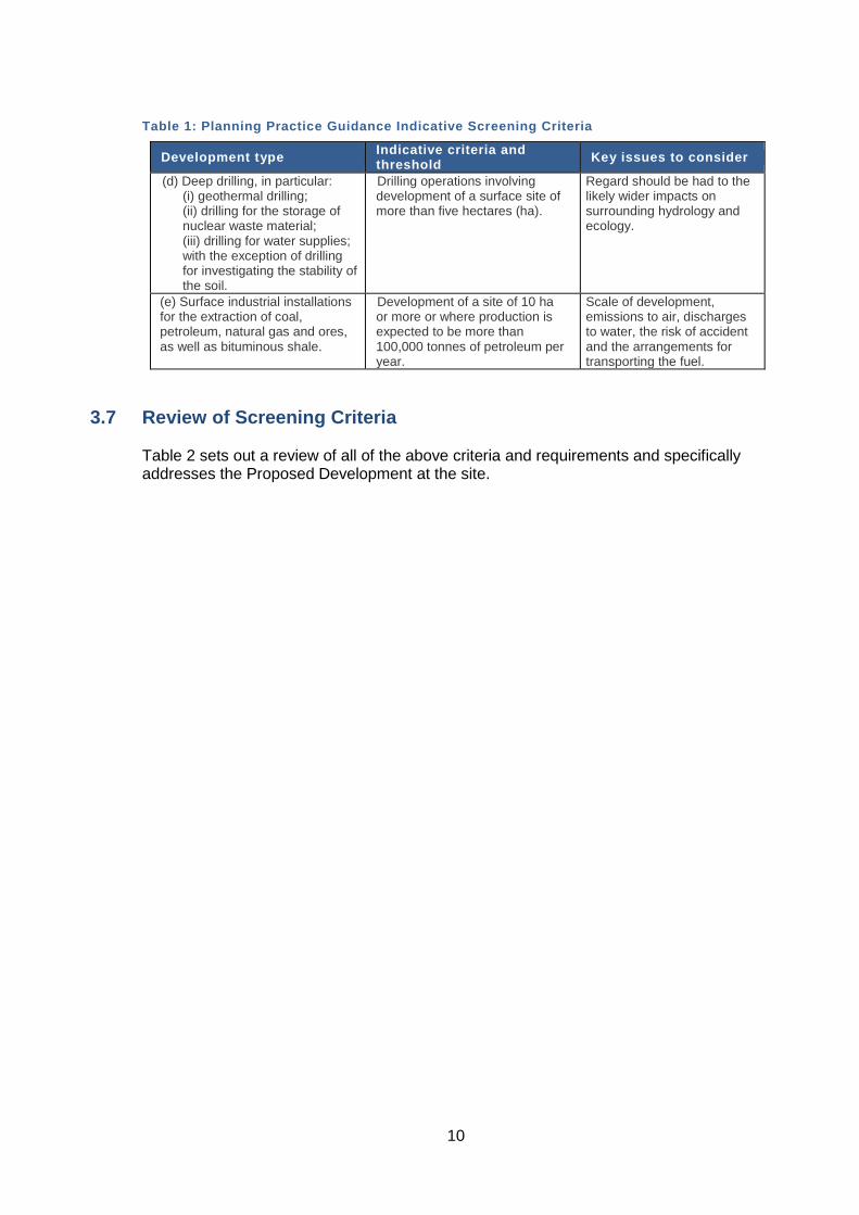
Paragraphs 057 and 058 of PPG provide guidance to help determine whether significant effects are likely. In general, the more environmentally sensitive the location, the lower the threshold will be at which significant effects are likely. Table 1 sets out indicative criteria and thresholds identified in the PPG along with some of the issues that are most likely to need to be considered in determining the whether a development is likely to be EIA development.
3 Paragraph: 024 Reference ID: 4-024-20140306
10
Table 1: Planning Practice Guidance Indicative Screening Criteria
Development type Indicative criteria and threshold Key issues to consider
(d) Deep drilling, in particular: (i) geothermal drilling; (ii) drilling for the storage of nuclear waste material; (iii) drilling for water supplies; with the exception of drilling for investigating the stability of the soil.
Drilling operations involving development of a surface site of more than five hectares (ha).
Regard should be had to the likely wider impacts on surrounding hydrology and ecology.
(e) Surface industrial installations for the extraction of coal, petroleum, natural gas and ores, as well as bituminous shale.
Development of a site of 10 ha or more or where production is expected to be more than 100,000 tonnes of petroleum per year.
Scale of development, emissions to air, discharges to water, the risk of accident and the arrangements for transporting the fuel.
3.7 Review of Screening Criteria Table 2 sets out a review of all of the above criteria and requirements and specifically addresses the Proposed Development at the site.
11
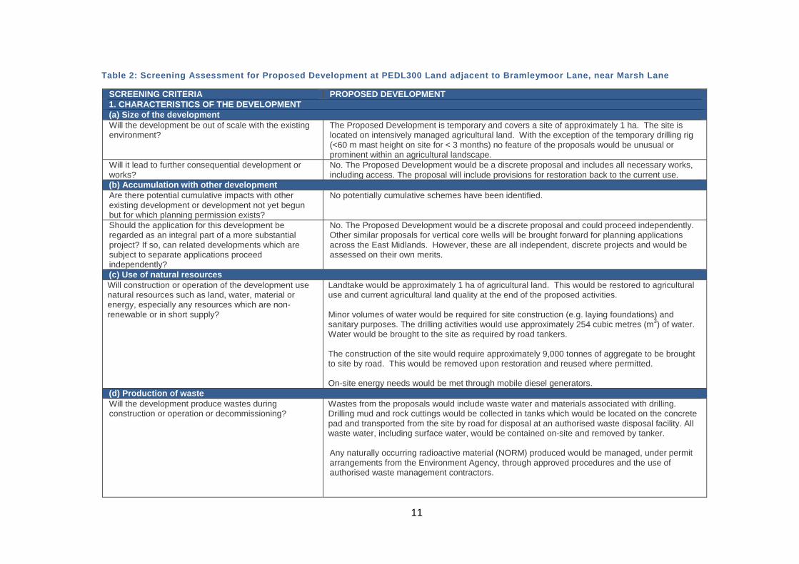
Table 2: Screening Assessment for Proposed Development at PEDL300 Land adjacent to Bramleymoor Lane, near Marsh Lane
SCREENING CRITERIA PROPOSED DEVELOPMENT 1. CHARACTERISTICS OF THE DEVELOPMENT (a) Size of the development Will the development be out of scale with the existing environment?
The Proposed Development is temporary and covers a site of approximately 1 ha. The site is located on intensively managed agricultural land. With the exception of the temporary drilling rig (<60 m mast height on site for < 3 months) no feature of the proposals would be unusual or prominent within an agricultural landscape.
Will it lead to further consequential development or works?
No. The Proposed Development would be a discrete proposal and includes all necessary works, including access. The proposal will include provisions for restoration back to the current use.
(b) Accumulation with other development Are there potential cumulative impacts with other existing development or development not yet begun but for which planning permission exists?
No potentially cumulative schemes have been identified.
Should the application for this development be regarded as an integral part of a more substantial project? If so, can related developments which are subject to separate applications proceed independently?
No. The Proposed Development would be a discrete proposal and could proceed independently. Other similar proposals for vertical core wells will be brought forward for planning applications across the East Midlands. However, these are all independent, discrete projects and would be assessed on their own merits.
(c) Use of natural resources Will construction or operation of the development use natural resources such as land, water, material or energy, especially any resources which are non-renewable or in short supply?
Landtake would be approximately 1 ha of agricultural land. This would be restored to agricultural use and current agricultural land quality at the end of the proposed activities. Minor volumes of water would be required for site construction (e.g. laying foundations) and sanitary purposes. The drilling activities would use approximately 254 cubic metres (m3) of water. Water would be brought to the site as required by road tankers. The construction of the site would require approximately 9,000 tonnes of aggregate to be brought to site by road. This would be removed upon restoration and reused where permitted. On-site energy needs would be met through mobile diesel generators.
(d) Production of waste Will the development produce wastes during construction or operation or decommissioning?
Wastes from the proposals would include waste water and materials associated with drilling. Drilling mud and rock cuttings would be collected in tanks which would be located on the concrete pad and transported from the site by road for disposal at an authorised waste disposal facility. All waste water, including surface water, would be contained on-site and removed by tanker. Any naturally occurring radioactive material (NORM) produced would be managed, under permit arrangements from the Environment Agency, through approved procedures and the use of authorised waste management contractors.
12
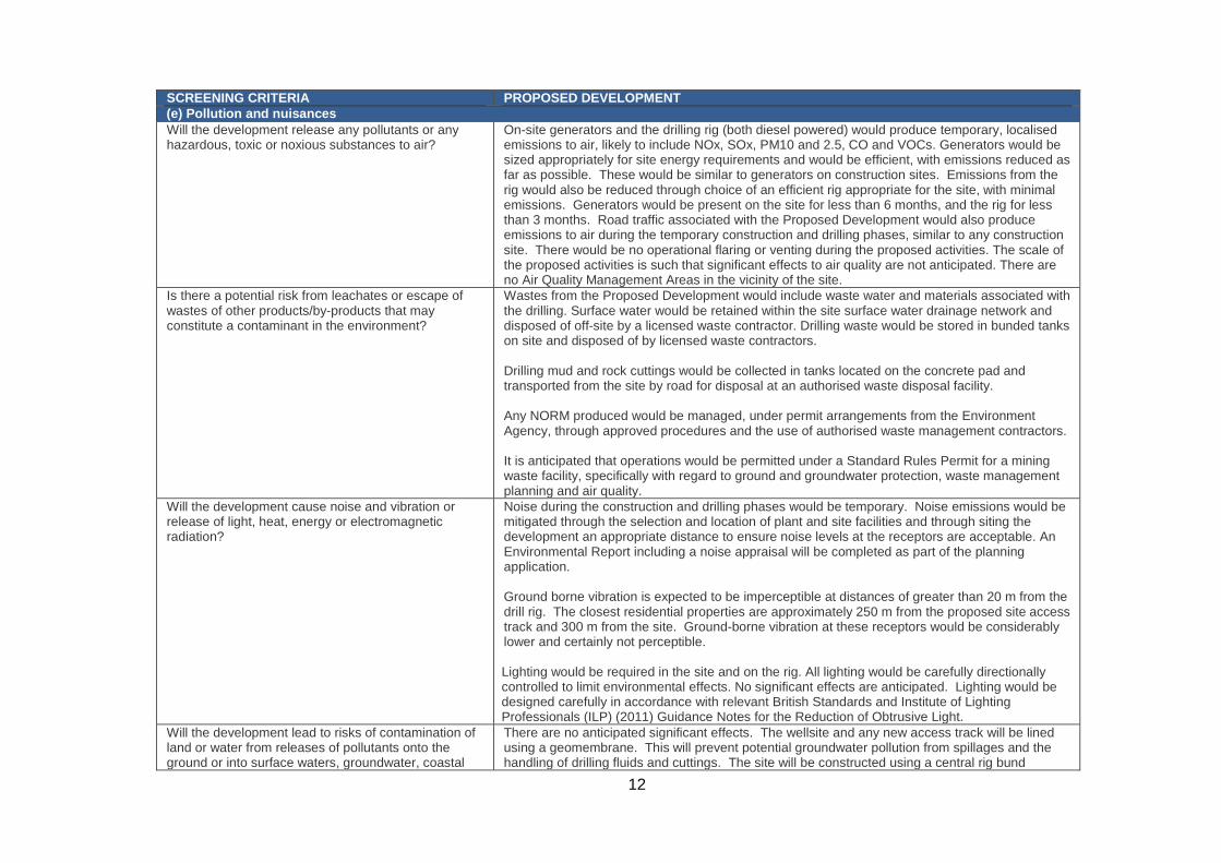
SCREENING CRITERIA PROPOSED DEVELOPMENT (e) Pollution and nuisances Will the development release any pollutants or any hazardous, toxic or noxious substances to air?
On-site generators and the drilling rig (both diesel powered) would produce temporary, localised emissions to air, likely to include NOx, SOx, PM10 and 2.5, CO and VOCs. Generators would be sized appropriately for site energy requirements and would be efficient, with emissions reduced as far as possible. These would be similar to generators on construction sites. Emissions from the rig would also be reduced through choice of an efficient rig appropriate for the site, with minimal emissions. Generators would be present on the site for less than 6 months, and the rig for less than 3 months. Road traffic associated with the Proposed Development would also produce emissions to air during the temporary construction and drilling phases, similar to any construction site. There would be no operational flaring or venting during the proposed activities. The scale of the proposed activities is such that significant effects to air quality are not anticipated. There are no Air Quality Management Areas in the vicinity of the site.
Is there a potential risk from leachates or escape of wastes of other products/by-products that may constitute a contaminant in the environment?
Wastes from the Proposed Development would include waste water and materials associated with the drilling. Surface water would be retained within the site surface water drainage network and disposed of off-site by a licensed waste contractor. Drilling waste would be stored in bunded tanks on site and disposed of by licensed waste contractors. Drilling mud and rock cuttings would be collected in tanks located on the concrete pad and transported from the site by road for disposal at an authorised waste disposal facility. Any NORM produced would be managed, under permit arrangements from the Environment Agency, through approved procedures and the use of authorised waste management contractors. It is anticipated that operations would be permitted under a Standard Rules Permit for a mining waste facility, specifically with regard to ground and groundwater protection, waste management planning and air quality.
Will the development cause noise and vibration or release of light, heat, energy or electromagnetic radiation?
Noise during the construction and drilling phases would be temporary. Noise emissions would be mitigated through the selection and location of plant and site facilities and through siting the development an appropriate distance to ensure noise levels at the receptors are acceptable. An Environmental Report including a noise appraisal will be completed as part of the planning application. Ground borne vibration is expected to be imperceptible at distances of greater than 20 m from the drill rig. The closest residential properties are approximately 250 m from the proposed site access track and 300 m from the site. Ground-borne vibration at these receptors would be considerably lower and certainly not perceptible. Lighting would be required in the site and on the rig. All lighting would be carefully directionally controlled to limit environmental effects. No significant effects are anticipated. Lighting would be designed carefully in accordance with relevant British Standards and Institute of Lighting Professionals (ILP) (2011) Guidance Notes for the Reduction of Obtrusive Light.
Will the development lead to risks of contamination of land or water from releases of pollutants onto the ground or into surface waters, groundwater, coastal
There are no anticipated significant effects. The wellsite and any new access track will be lined using a geomembrane. This will prevent potential groundwater pollution from spillages and the handling of drilling fluids and cuttings. The site will be constructed using a central rig bund
13
SCREENING CRITERIA PROPOSED DEVELOPMENT waters or the sea? drainage system which will be segregated from the remainder of the site to prevent potential
contamination of the surrounding surfaces in the event of a spillage. Following the drilling operations, the aggregate and concrete would be fully removed from the site before the impermeable liner is removed.
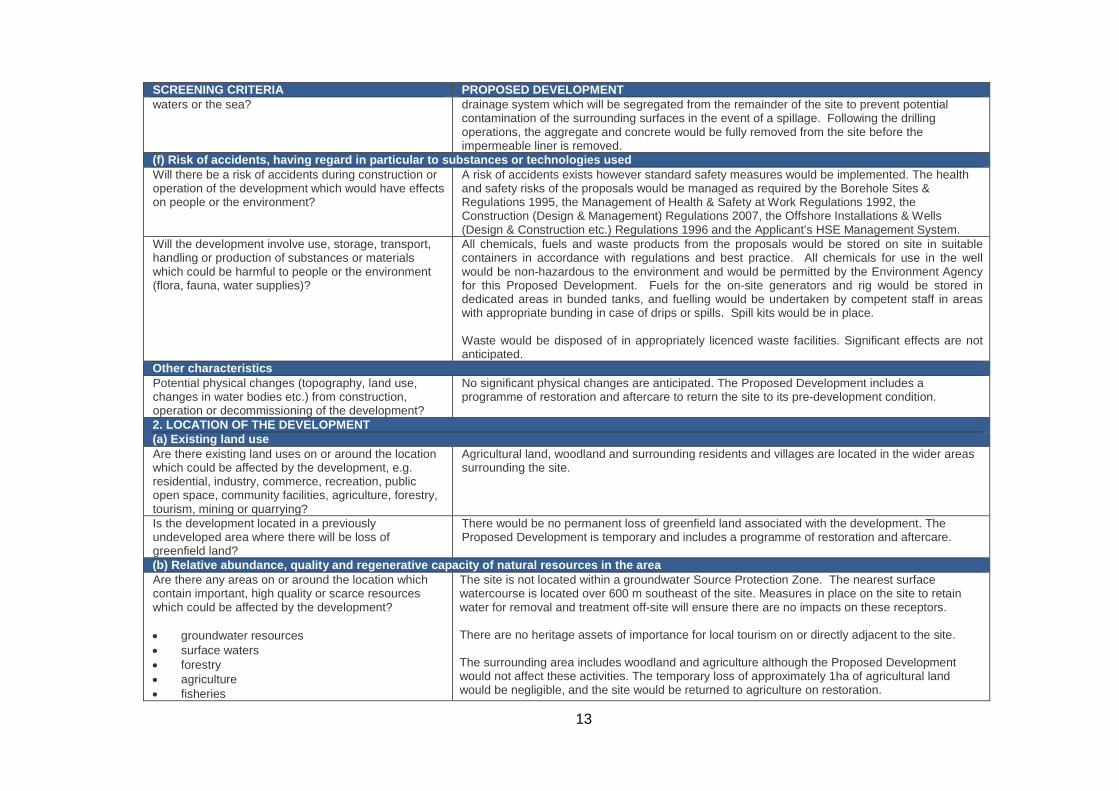
(f) Risk of accidents, having regard in particular to substances or technologies used Will there be a risk of accidents during construction or operation of the development which would have effects on people or the environment?
A risk of accidents exists however standard safety measures would be implemented. The health and safety risks of the proposals would be managed as required by the Borehole Sites & Regulations 1995, the Management of Health & Safety at Work Regulations 1992, the Construction (Design & Management) Regulations 2007, the Offshore Installations & Wells (Design & Construction etc.) Regulations 1996 and the Applicant’s HSE Management System.
Will the development involve use, storage, transport, handling or production of substances or materials which could be harmful to people or the environment (flora, fauna, water supplies)?
All chemicals, fuels and waste products from the proposals would be stored on site in suitable containers in accordance with regulations and best practice. All chemicals for use in the well would be non-hazardous to the environment and would be permitted by the Environment Agency for this Proposed Development. Fuels for the on-site generators and rig would be stored in dedicated areas in bunded tanks, and fuelling would be undertaken by competent staff in areas with appropriate bunding in case of drips or spills. Spill kits would be in place. Waste would be disposed of in appropriately licenced waste facilities. Significant effects are not anticipated.
Other characteristics Potential physical changes (topography, land use, changes in water bodies etc.) from construction, operation or decommissioning of the development?
No significant physical changes are anticipated. The Proposed Development includes a programme of restoration and aftercare to return the site to its pre-development condition.
2. LOCATION OF THE DEVELOPMENT (a) Existing land use Are there existing land uses on or around the location which could be affected by the development, e.g. residential, industry, commerce, recreation, public open space, community facilities, agriculture, forestry, tourism, mining or quarrying?
Agricultural land, woodland and surrounding residents and villages are located in the wider areas surrounding the site.
Is the development located in a previously undeveloped area where there will be loss of greenfield land?
There would be no permanent loss of greenfield land associated with the development. The Proposed Development is temporary and includes a programme of restoration and aftercare.
(b) Relative abundance, quality and regenerative capacity of natural resources in the area Are there any areas on or around the location which contain important, high quality or scarce resources which could be affected by the development? • groundwater resources • surface waters • forestry • agriculture • fisheries
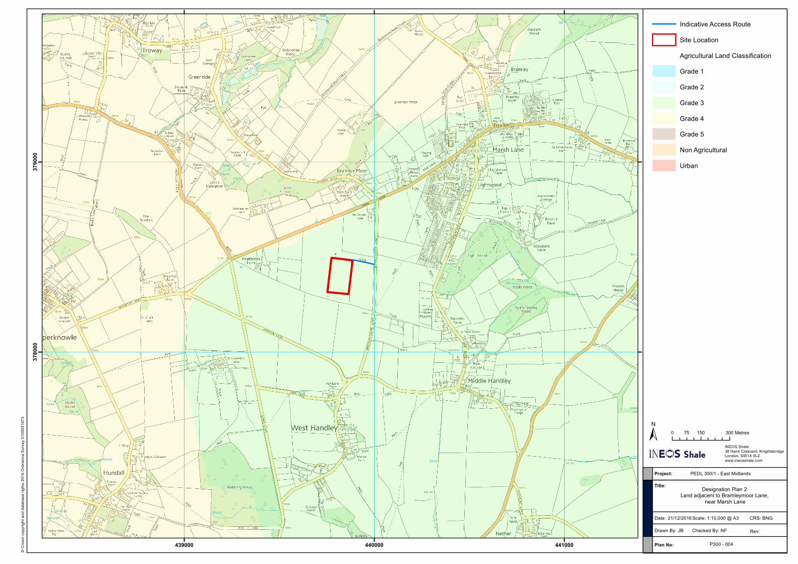
The site is not located within a groundwater Source Protection Zone. The nearest surface watercourse is located over 600 m southeast of the site. Measures in place on the site to retain water for removal and treatment off-site will ensure there are no impacts on these receptors. There are no heritage assets of importance for local tourism on or directly adjacent to the site. The surrounding area includes woodland and agriculture although the Proposed Development would not affect these activities. The temporary loss of approximately 1ha of agricultural land would be negligible, and the site would be returned to agriculture on restoration.
14
SCREENING CRITERIA PROPOSED DEVELOPMENT • tourism • minerals
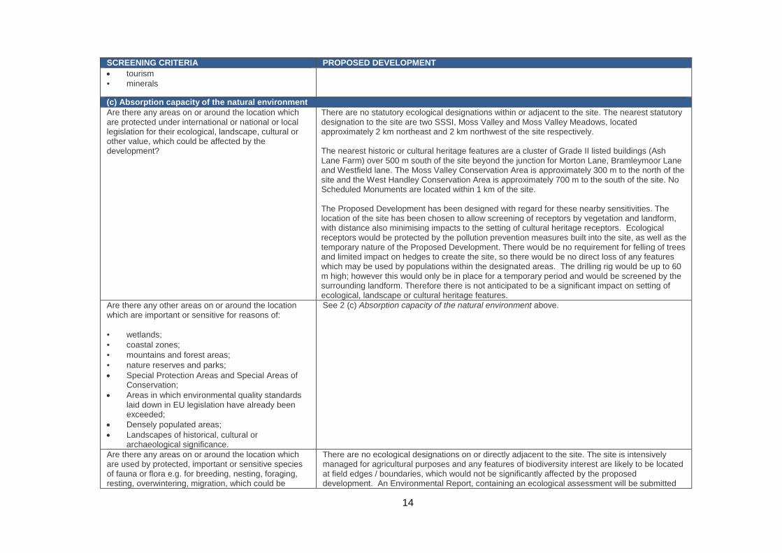
(c) Absorption capacity of the natural environment Are there any areas on or around the location which are protected under international or national or local legislation for their ecological, landscape, cultural or other value, which could be affected by the development?
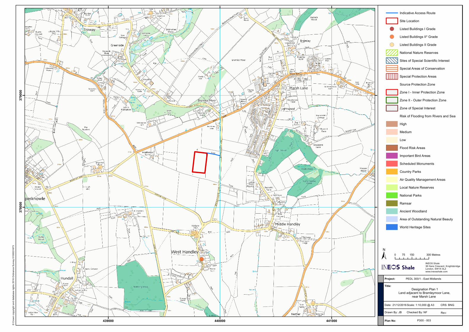
There are no statutory ecological designations within or adjacent to the site. The nearest statutory designation to the site are two SSSI, Moss Valley and Moss Valley Meadows, located approximately 2 km northeast and 2 km northwest of the site respectively. The nearest historic or cultural heritage features are a cluster of Grade II listed buildings (Ash Lane Farm) over 500 m south of the site beyond the junction for Morton Lane, Bramleymoor Lane and Westfield lane. The Moss Valley Conservation Area is approximately 300 m to the north of the site and the West Handley Conservation Area is approximately 700 m to the south of the site. No Scheduled Monuments are located within 1 km of the site. The Proposed Development has been designed with regard for these nearby sensitivities. The location of the site has been chosen to allow screening of receptors by vegetation and landform, with distance also minimising impacts to the setting of cultural heritage receptors. Ecological receptors would be protected by the pollution prevention measures built into the site, as well as the temporary nature of the Proposed Development. There would be no requirement for felling of trees and limited impact on hedges to create the site, so there would be no direct loss of any features which may be used by populations within the designated areas. The drilling rig would be up to 60 m high; however this would only be in place for a temporary period and would be screened by the surrounding landform. Therefore there is not anticipated to be a significant impact on setting of ecological, landscape or cultural heritage features.
Are there any other areas on or around the location which are important or sensitive for reasons of: • wetlands; • coastal zones; • mountains and forest areas; • nature reserves and parks; • Special Protection Areas and Special Areas of
Conservation; • Areas in which environmental quality standards
laid down in EU legislation have already been exceeded;
• Densely populated areas; • Landscapes of historical, cultural or
archaeological significance.
See 2 (c) Absorption capacity of the natural environment above.
Are there any areas on or around the location which are used by protected, important or sensitive species of fauna or flora e.g. for breeding, nesting, foraging, resting, overwintering, migration, which could be
There are no ecological designations on or directly adjacent to the site. The site is intensively managed for agricultural purposes and any features of biodiversity interest are likely to be located at field edges / boundaries, which would not be significantly affected by the proposed development. An Environmental Report, containing an ecological assessment will be submitted
15
SCREENING CRITERIA PROPOSED DEVELOPMENT affected? with the planning application.
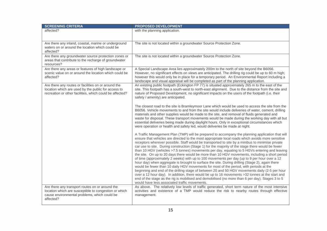
Are there any inland, coastal, marine or underground waters on or around the location which could be affected?
The site is not located within a groundwater Source Protection Zone.
Are there any groundwater source protection zones or areas that contribute to the recharge of groundwater resources?
The site is not located within a groundwater Source Protection Zone.
Are there any areas or features of high landscape or scenic value on or around the location which could be affected?
A Special Landscape Area lies approximately 200m to the north of site beyond the B6056. However, no significant effects on views are anticipated. The drilling rig could be up to 60 m high; however this would only be in place for a temporary period. An Environmental Report including a landscape and visual appraisal will be completed as part of the planning application.
Are there any routes or facilities on or around the location which are used by the public for access to recreation or other facilities, which could be affected?
An existing public footpath (Eckington FP 77) is situated approximately 265 m to the east of the site. This footpath has a south-west to north-east alignment. Due to the distance from the site and nature of Proposed Development, no significant impacts on the users of the footpath (i.e. their safety / amenity) are anticipated. The closest road to the site is Bramleymoor Lane which would be used to access the site from the B6056. Vehicle movements to and from the site would include deliveries of water, cement, drilling materials and other supplies would be made to the site, and removal of fluids generated and waste for disposal. These transport movements would be made during the working day with all but essential deliveries being made during daylight hours. Only in exceptional circumstances which were operation or health and safety led, would deliveries be made at night. A Traffic Management Plan (TMP) will be prepared to accompany the planning application that will ensure that vehicles are directed to the most appropriate local roads which avoids more sensitive receptors wherever possible. Staff would be transported to site by a minibus to minimise private car use to site. During construction (Stage 1) for the majority of the stage there would be fewer than 10 HGV (vehicles >7.5 tonnes) movements per day, equating to 5 HGVs entering and leaving the site. On up to 20 days there would be more than 10 HGV movements, including a short period of time (approximately 2 weeks) with up to 100 movements per day (up to 9 per hour over a 12 hour day) when aggregate is brought to surface the site. During drilling (Stage 2), again there would be fewer than 10 daily HGV movements for most of the period, with periods at the beginning and end of the drilling stage of between 20 and 50 HGV movements daily (2-5 per hour over a 12 hour day). In addition, there would be up to 16 movements >32 tonnes at the start and end of the stage as the rig is mobilised and demobilised (no more than 6 per day). Stages 3 to 5 would have less associated traffic movements.
Are there any transport routes on or around the location which are susceptible to congestion or which cause environmental problems, which could be affected?
As above. The relatively low levels of traffic generated, short term nature of the most intensive activities and existence of a TMP would reduce the risk to nearby routes through effective management.
16
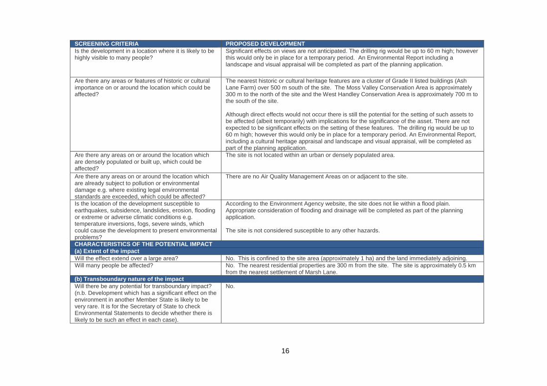
SCREENING CRITERIA PROPOSED DEVELOPMENT Is the development in a location where it is likely to be highly visible to many people?
Significant effects on views are not anticipated. The drilling rig would be up to 60 m high; however this would only be in place for a temporary period. An Environmental Report including a landscape and visual appraisal will be completed as part of the planning application.
Are there any areas or features of historic or cultural importance on or around the location which could be affected?
The nearest historic or cultural heritage features are a cluster of Grade II listed buildings (Ash Lane Farm) over 500 m south of the site. The Moss Valley Conservation Area is approximately 300 m to the north of the site and the West Handley Conservation Area is approximately 700 m to the south of the site. Although direct effects would not occur there is still the potential for the setting of such assets to be affected (albeit temporarily) with implications for the significance of the asset. There are not expected to be significant effects on the setting of these features. The drilling rig would be up to 60 m high; however this would only be in place for a temporary period. An Environmental Report, including a cultural heritage appraisal and landscape and visual appraisal, will be completed as part of the planning application.
Are there any areas on or around the location which are densely populated or built up, which could be affected?
The site is not located within an urban or densely populated area.
Are there any areas on or around the location which are already subject to pollution or environmental damage e.g. where existing legal environmental standards are exceeded, which could be affected?
There are no Air Quality Management Areas on or adjacent to the site.
Is the location of the development susceptible to earthquakes, subsidence, landslides, erosion, flooding or extreme or adverse climatic conditions e.g. temperature inversions, fogs, severe winds, which could cause the development to present environmental problems?
According to the Environment Agency website, the site does not lie within a flood plain. Appropriate consideration of flooding and drainage will be completed as part of the planning application. The site is not considered susceptible to any other hazards.
CHARACTERISTICS OF THE POTENTIAL IMPACT (a) Extent of the impact Will the effect extend over a large area? No. This is confined to the site area (approximately 1 ha) and the land immediately adjoining. Will many people be affected? No. The nearest residential properties are 300 m from the site. The site is approximately 0.5 km
from the nearest settlement of Marsh Lane. (b) Transboundary nature of the impact Will there be any potential for transboundary impact? (n.b. Development which has a significant effect on the environment in another Member State is likely to be very rare. It is for the Secretary of State to check Environmental Statements to decide whether there is likely to be such an effect in each case).
No.
17
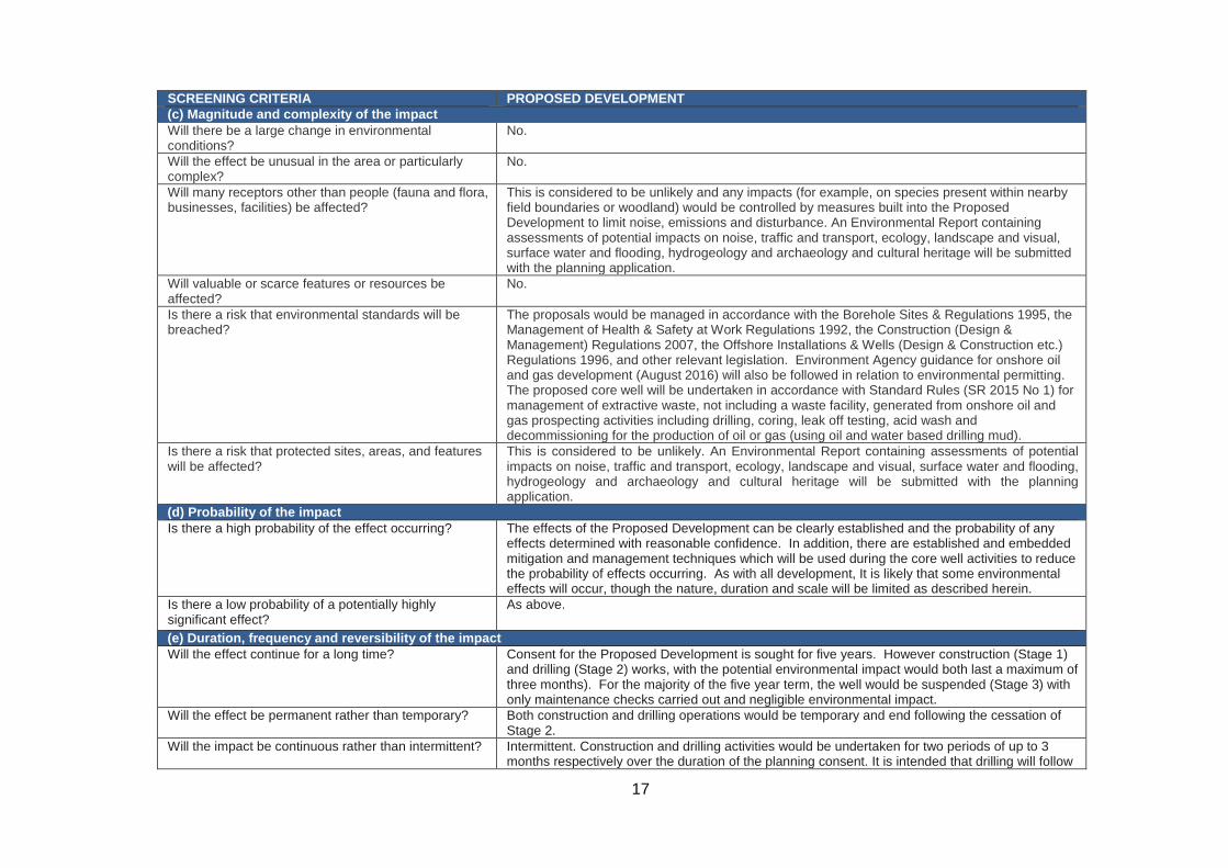
SCREENING CRITERIA PROPOSED DEVELOPMENT (c) Magnitude and complexity of the impact Will there be a large change in environmental conditions?
No.
Will the effect be unusual in the area or particularly complex?
No.
Will many receptors other than people (fauna and flora, businesses, facilities) be affected?
This is considered to be unlikely and any impacts (for example, on species present within nearby field boundaries or woodland) would be controlled by measures built into the Proposed Development to limit noise, emissions and disturbance. An Environmental Report containing assessments of potential impacts on noise, traffic and transport, ecology, landscape and visual, surface water and flooding, hydrogeology and archaeology and cultural heritage will be submitted with the planning application.
Will valuable or scarce features or resources be affected?
No.
Is there a risk that environmental standards will be breached?
The proposals would be managed in accordance with the Borehole Sites & Regulations 1995, the Management of Health & Safety at Work Regulations 1992, the Construction (Design & Management) Regulations 2007, the Offshore Installations & Wells (Design & Construction etc.) Regulations 1996, and other relevant legislation. Environment Agency guidance for onshore oil and gas development (August 2016) will also be followed in relation to environmental permitting. The proposed core well will be undertaken in accordance with Standard Rules (SR 2015 No 1) for management of extractive waste, not including a waste facility, generated from onshore oil and gas prospecting activities including drilling, coring, leak off testing, acid wash and decommissioning for the production of oil or gas (using oil and water based drilling mud).
Is there a risk that protected sites, areas, and features will be affected?
This is considered to be unlikely. An Environmental Report containing assessments of potential impacts on noise, traffic and transport, ecology, landscape and visual, surface water and flooding, hydrogeology and archaeology and cultural heritage will be submitted with the planning application.
(d) Probability of the impact Is there a high probability of the effect occurring? The effects of the Proposed Development can be clearly established and the probability of any
effects determined with reasonable confidence. In addition, there are established and embedded mitigation and management techniques which will be used during the core well activities to reduce the probability of effects occurring. As with all development, It is likely that some environmental effects will occur, though the nature, duration and scale will be limited as described herein.
Is there a low probability of a potentially highly significant effect?
As above.
(e) Duration, frequency and reversibility of the impact Will the effect continue for a long time? Consent for the Proposed Development is sought for five years. However construction (Stage 1)
and drilling (Stage 2) works, with the potential environmental impact would both last a maximum of three months). For the majority of the five year term, the well would be suspended (Stage 3) with only maintenance checks carried out and negligible environmental impact.
Will the effect be permanent rather than temporary? Both construction and drilling operations would be temporary and end following the cessation of Stage 2.
Will the impact be continuous rather than intermittent? Intermittent. Construction and drilling activities would be undertaken for two periods of up to 3 months respectively over the duration of the planning consent. It is intended that drilling will follow
18
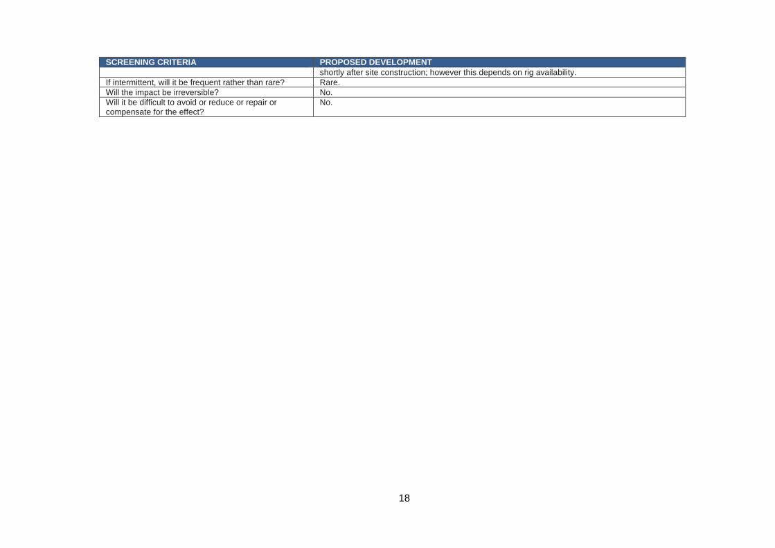
SCREENING CRITERIA PROPOSED DEVELOPMENT shortly after site construction; however this depends on rig availability.
If intermittent, will it be frequent rather than rare? Rare. Will the impact be irreversible? No. Will it be difficult to avoid or reduce or repair or compensate for the effect?
No.
19
4. Conclusion This screening assessment has considered whether the Proposed Development is likely to give rise to significant effects on the environment. The Proposed Development falls under Schedule 2 of the EIA Regulations as the site exceeds the legislative area thresholds. However, it does not exceed indicative thresholds and criteria within the PPG and is not located in a sensitive area as defined by the EIA Regulations. Table 2 sets out the baseline environmental conditions in the area on and adjacent to the site. The potential exists for effects on ground and surface water, air quality, views and noise; however the site is located in an agricultural area with few adjacent sensitive receptors and therefore the potential for significant effects is considered to be unlikely. Standard proven mitigation measures will be employed as used on other similar types of development. Accordingly, the screening assessment has identified that significant effects on the environment are not considered likely either alone or in combination with other development and therefore the Proposed Development should not be considered to constitute EIA development as defined by the EIA Regulations. As outlined in this report, the future planning application would include an Environmental Report addressing the aspects of water environment, ecology, noise, landscape and visual effects, and cultural heritage. Given the scale of the Proposed Development this is considered appropriate to allow the MPA to consider the material matters pertaining to the future application.

Appendix 1 Site Location Plan
440000
± 0 40 8020 Metres
INEOS Shale38 Hans Crescent, KnightsbridgeLondon, SW1X 0LZwww.ineosshale.com
Project:
Title:
Plan No:
Date:
Drawn By: JB
PEDL300/1 - East Midlands
Site Location PlanLand adjacent to Bramleymoor Lane,
near Marsh Lane
21/12/2016 Scale: 1:2,500 @ A3 CRS: BNG
Checked By: NF Rev:
Indicative Access Route
Site Location
P300-001
Note: The site area shown illustrates the land holding currently beingconsidered within which the corewell site would be located.
© Cr
own c
opyri
ght a
nd da
tabas
e righ
ts 20
16 O
rdnan
ce S
urvey
0100
0316
73
439000 440000 441000
3780
0037
9000
± 0 150 30075 Metres
INEOS Shale38 Hans Crescent, KnightsbridgeLondon, SW1X 0LZwww.ineosshale.com
Project:
Title:
Plan No:
Date:
Drawn By: JB
PEDL 300/1 - East Midlands
Site Location PlanLand adjacent to Bramleymoor Lane,
near Marsh Lane
21/12/2016 Scale:1:10,000 @ A3 CRS: BNG
Checked By: NF Rev:
Indicative Access Route
Site Location
P300-002
Note: The site area shown illustrates the land holding currently beingconsidered within which the corewell site would be located.
© Cr
own c
opyri
ght a
nd da
tabas
e righ
ts 20
16 O
rdnan
ce S
urvey
0100
0316
73

Appendix 2 Designation Plan
439000 440000 441000
3780
0037
9000
± 0 150 30075 Metres
INEOS Shale38 Hans Crescent, KnightsbridgeLondon, SW1X 0LZwww.ineosshale.com
Project:
Title:
Plan No:
Date:
Drawn By: JB
PEDL 300/1 - East Midlands
Designation Plan 1Land adjacent to Bramleymoor Lane,
near Marsh Lane
21/12/2016 Scale: 1:10,000 @ A3 CRS: BNG
Checked By: NF Rev:
Indicative Access RouteSite Location
!( Listed Buildings I Grade
!( Listed Buildings II* Grade
!( Listed Buildings II GradeNational Nature ReservesSites of Special Scientific InterestSpecial Areas of ConservationSpecial Protection AreasSource Protection ZoneZone I - Inner Protection ZoneZone II - Outer Protection ZoneZone of Special InterestRisk of Flooding from Rivers and SeaHighMediumLowFlood Risk AreasImportant Bird AreasScheduled MonumentsCountry ParksAir Quality Management AreasLocal Nature ReservesNational ParksRamsarAncient WoodlandArea of Outstanding Natural BeautyWorld Heritage Sites
P300 - 003
© Cr
own c
opyri
ght a
nd da
tabas
e righ
ts 20
16 O
rdnan
ce S
urvey
0100
0316
73
439000 440000 441000
3780
0037
9000
± 0 150 30075 Metres
INEOS Shale38 Hans Crescent, KnightsbridgeLondon, SW1X 0LZwww.ineosshale.com
Project:
Title:
Plan No:
Date:
Drawn By: JB
PEDL 300/1 - East Midlands
Designation Plan 2 Land adjacent to Bramleymoor Lane,
near Marsh Lane
21/12/2016 Scale: 1:10,000 @ A3 CRS: BNG
Checked By: NF Rev:
Indicative Access RouteSite LocationAgricultural Land ClassificationGrade 1Grade 2Grade 3Grade 4Grade 5Non AgriculturalUrban
P300 - 004
© Cr
own c
opyri
ght a
nd da
tabas
e righ
ts 20
16 O
rdnan
ce S
urvey
0100
0316
73