Embed Size (px)
Citation preview

National Environmental Policy Act (NEPA) Screening Report
Prepared for: Optasite Towers, LLC One Research Drive, Suite 200C Danbury, CT 01581
DANBURY 1 / OPT006 52 Stadley Rough Road Danbury, Connecticut EBI Project No. 61053482 Site Report Date: June 7, 2007

ENVIROBUSINESS, INC. LOCATIONS | ATLANTA, GA | BALTIMORE, MD | BURLINGTON, MA | CHICAGO, IL |
CRANSTON, RI | DALLAS, TX | DENVER, CO | EXETER, NH | HOUSTON, TX | LOS ANGELES, CA | NEW YORK, NY | PHOENIX, AZ | PORTLAND, OR | SAN FRANCISCO, CA | SEATTLE, WA | YORK, PA
June 8, 2007 Mr. Keith Coppins Optasite Towers, LLC One Research Drive, Suite 200C Danbury, CT 01581 Subject: National Environmental Policy Act (NEPA) Screening Report
Danbury 1 / OPT006 52 Stadley Rough Road, Danbury, Connecticut EBI Project #61053482
Dear Mr. Coppins: Attached please find our National Environmental Policy Act (NEPA) Screening Report, (the Report) for the proposed telecommunications installation at the address noted above (the Subject Property). The purpose of this Report is to evaluate the above-referenced property for environmental and historical concerns specified by the Federal Communications Commission (FCC) in 47 CFR 1.1307, and general industry standards. The Subject Property, known as Danbury 1, consists of an approximately 5.2-acre lot that is improved with a church building located towards the northeast quadrant of the property. The church was constructed in 1972 and has always been occupied by the Candlewood Baptist Church. The Project Site is located in the area of undeveloped woodland in the southwest quadrant of Subject Property. Optasite Towers, LLC (Optasite) proposes to construct a tower facility on the southwestern portion of the Subject Property (herein, the Project Site). The tower facility will include a 130-foot monopole tower located within a fenced 50-foot by 90-foot gravel compound. Equipment shelters, antenna arrays, and applicable conduits will be constructed separately by outside carriers. A pad mounted transformer and multi-meter center will be located at the northeastern corner of the tower compound. Optasite proposes to improve a 12-foot wide by 80-foot long gravel access road with underground utilities from the existing western access drive of the church to the tower area. Please find the attached National Environmental Policy Act (NEPA) Checklist, NEPA Summary Report, and associated documentation for the above referenced site. Based upon the results of our assessment, it appears that the proposed installation will not adversely impact any of the criteria as outlined in 1.1307(a) items (1) through (8) and preparation of an Environmental Assessment (EA) is not required. The Report was completed according to the terms and conditions authorized by you. There are no intended or unintended third party beneficiaries to this Report, unless specifically named. EBI is an independent contractor, not an employee of either the property owner or the project proponent, and its compensation was not based on the findings or recommendations made in the Report or on the closing of any business transaction. Note that the findings of this Report are based on the project specifications provided to EBI and described in this Report. In the event that the design or location of the installation changes, please contact EBI as additional review and/or consultation may be required.
21 B StreetBurlington, MA 01803
Tel: (781) 273-2500Fax: (781) 273.3311

ENVIROBUSINESS, INC. LOCATIONS | ATLANTA, GA | BALTIMORE, MD | BURLINGTON, MA | CHICAGO, IL |
CRANSTON, RI | DALLAS, TX | DENVER, CO | EXETER, NH | HOUSTON, TX | LOS ANGELES, CA | NEW YORK, NY | PHOENIX, AZ | PORTLAND, OR | SAN FRANCISCO, CA | SEATTLE, WA | YORK, PA
Thank you for the opportunity to prepare this Report, and assist you with this project. Please call us if you have any questions or if we may be of further assistance. Respectfully Submitted, Ms. Nicole Piretti Mr. Christopher W. Baird Mr. Jeffery Previte Author/Project Scientist Reviewer/Program Manager VP - Telecom Business Development Direct# (617) 715-1846 Appendix A – NEPA Checklist Appendix B – FCC NEPA Summary Report Appendix C – Figures, Drawings, and Maps Appendix D – SHPO Correspondence Appendix E – Tribal Correspondence Appendix F – Land Resources Map Appendix G – Federal and State Fish and Wildlife Service Correspondence Appendix H – Wetlands Map Appendix I – FEMA Floodplain Map

EBI Consulting
APPENDIX A NEPA CHECKLIST

EBI Consulting
Signature: Company: EBI Consulting Print name: Nicole Piretti Date: June 7, 2007
Site type (choose one): Raw land Tower colo Other colo Tower Replacement
Site ID: Danbury 1 / OPT006
Site Address: 52 Stadley Rough Road, Danbury, Connecticut
NEPA Land Use Screening Checklist Check appropriate boxes below FCC NEPA
Category Consulting Agency to
Contact No Adverse Impact
Potential Adverse Impact
Exempt from Review NPA Applies
Designated Wilderness Areas
National Park Service, US Forest Service, Bureau of Land Management (BLM)
Designated Wildlife Preserves
National Park Service, US Forest Service, BLM
Threatened or Endangered Species & Critical Habitats
US Fish & Wildlife Service - Field Office (USF&WS)
Historic Places State Historic Preservation Officer (SHPO), Tribal Historic Preservation Officer (THPO)
SHPO consultation
completed
Collocation Agreement:
applies
Nationwide Agreement
Exclusion applies:
Indian Religious Sites
American Indian Tribes, Bureau of Indian Affairs
Tribal consultation
completed
Collocation Agreement
applies:
Nationwide Agreement
Exclusion applies:
Floodplain Federal Emergency Management Agency (FEMA)
Wetlands & Surface Waterways
USF&WS NWI Maps US Army Corps of Engineers (ACOE)

EBI Consulting
APPENDIX B FCC NEPA SUMMARY REPORT

EBI Consulting
FCC NEPA Summary Report (47 CFR Subpart 1, Chapter 1, Sections 1.1301-1.1319)
1. Is the antenna structure located in an officially designated wilderness area?
According to a review of the Land Resources Map (http://ims.goebi.com) (Appendix F) and the Department of Agriculture’s list of wilderness areas (http://www.wilderness.net/index.cfm?fuse=NWPS), the Project Site is not located in an officially designated wilderness area. In addition, according to EBI’s review of available on-line resources, the Project Site is not located in a National Park (www.nps.gov/gis), NPS Interactive Map Center), a designated Scenic and Wild River (http://www.rivers.gov/wildriverslist.html), a land area managed by the Bureau of Land Management (www.blm.gov/nhp/facts/index.htm), or within ¼ mile of a National Scenic Trail as identified by the National Park Service (http://www.nps.gov/ncrc/programs/nts/nts_trails.html).
2. Is the antenna structure located in an officially designated wildlife preserve?
According to a review of the Land Resources Map (Appendix F), the Project Site is not located in an officially designated wildlife preserve. In addition, according to EBI’s review of available on-line resources, the Project Site is not located in a US Fish and Wildlife Service National Wildlife Refuge (http://www.fws.gov/refuges/refugeLocatorMaps/index.html).
3. Will the antenna structure likely affect threatened or endangered species or designated
critical habitats? (Ref. 50 CFR Part 402)
According to a review of the Land Resources Map (Appendix F), no identified threatened or endangered species habitats or designated critical habitats are located in the vicinity of the Project Site. EBI submitted letters and project information requesting comments on the impacts of the project on threatened or endangered species to the Connecticut Department of Environmental Protection, Bureau of Natural Resources, Division of Wildlife and the United States Department of Fisheries and Wildlife on January 20, 2006. These agencies responded on January 26 and February 1, 2006, respectively, indicating that there are no known Federally- or State-listed and/or proposed threatened or endangered species at the proposed Project Site. Copies of this correspondence are included in Appendix G. Additionally based upon the proposed design monopole and height (under 250 feet AGL) it is unlikely that the proposed telecommunications installation would adversely impact migratory bird species protected under the Migratory Bird Treaty Act and the Endangered Species Act. Therefore, EBI concludes that the proposed project is unlikely to affect threatened or endangered species.
4. Will the antenna structure affect districts, sites, buildings, structures, or objects significant
in American history, architecture, archeology, engineering, or culture that are listed, or potentially eligible for listing in the National Register of Historic Places (NRHP)? (Ref. 36 CFR Part 800 regulations implementing Section 106 of the National Historic Preservation Act).
EBI reviewed the proposed project plans against the Exclusions of the Nationwide Programmatic Agreement Regarding the Section 106 National Historic Preservation Act Review Process (NPA). EBI concluded that the proposed tower construction does not meet any of the Exclusions listed in Section III of the NPA. Therefore, consultation with the Connecticut State Historic Preservation Officer (SHPO) was required. Based on EBI’s review of files online at the National Register Information System (www.nr.nps.gov), Connecticut SHPO, and the map of Known Cultural Resources provided by Heritage Consultants, LLC
Site type (choose one): Raw land Tower colo Other colo Tower Replacement
Site ID: Danbury 1 / OPT006
Site Address: 52 Stadley Rough Road, Danbury, Connecticut

EBI Consulting
(Heritage), no Historic Properties were identified within the ½-mile Area of Potential Effect (APE) for visual effects of the proposed tower. In a letter dated February 16, 2006, EBI requested that the Connecticut SHPO concur with EBI’s conclusion that the proposed facility would not adversely affect identified historic properties located within the surrounding area. EBI’s letter contained photographs, project plans and location maps of the installation for the SHPO’s review. In a response letter dated February 17, 2006, the Connecticut SHPO responded by indicating, “this project area possesses moderate to high sensitivity for prehistoric and historic archaeological resources. Therefore, we recommend that a professional reconnaissance survey be undertaken to identify and evaluate archaeological resources, which may exist within the proposed project limits, including equipment storage and associated work areas.” EBI contracted Heritage to perform an evaluation of the proposed Project Site for the likelihood of containing archaeological resources. Heritage concluded that the proposed Project Site retains “no potential to produce intact cultural deposits” and that “no additional testing of the Areas of Potential Effect is recommended at this time.” EBI submitted the results of the archaeological survey to the Connecticut SHPO. In correspondence dated April 11, 2006, the SHPO concurred with our determination, stating that “this office believes that the proposed undertaking will have no effect upon Connecticut’s archaeological heritage.” Please see Appendix D for copies of this correspondence. In the unlikely event that unanticipated Historic Properties, cultural artifacts, archeological deposits, or human remains are inadvertently encountered during the proposed construction and associated excavation activities, Optasite must halt activities immediately and contact the appropriate local officials and state agencies, in accordance with Federal and State regulations (36 CFR 800.13(b)).
5. Will the antenna structure affect Indian religious site(s)
Based on the requirements of the Nationwide Programmatic Agreement Regarding the Section 106 National Historic Preservation Act Review Process (NPA), Tribal consultation was required for this project because the proposed tower construction did not meet Exclusions A, B, C or F of the NPA. EBI submitted documentation regarding the proposed project to the FCC’s Tower Construction Notification System (TCNS). By January 13, 2006, the FCC’s TCNS sent the project information to Tribes listed on their database who have interest in the state in which the project is planned. Additionally, EBI submitted follow-up requests for comment to each of the Tribes indicated by the TCNS to have a potential interest in the area of the project. Tribal communication to date for this project is summarized in the following table.
# Tribe Name Initial
Notification (via TCNS)
Response to Initial Contact
Second Contact Attempt
Response to Second Attempt
Additional Contact
Attempts
Response to Third
Attempt
Action Recommended
1 Mashantucket Pequot Tribe
January 13, 2006
Requested a Phase I Archaeology Survey (January 17, 2006)
Provided archaeology report (May 24, 2006)
No further interest (May 26, 2006)
N/A N/A No Further Action
2 Narragansett Indian Tribe
January 13, 2006
Requested additional information (January 11, 2006)
February, 14, 2006
None April 25, 2006 June 21, 2006 May 3, 2007
No further interest (May 23, 2007)
No Further Action
In the unlikely event that unanticipated Historic Properties, cultural artifacts, archeological deposits, or human remains are inadvertently encountered during the proposed construction and associated excavation activities, Optasite must halt activities immediately and contact the appropriate tribal governments, local officials and state agencies, in accordance with Federal and State regulations (36 CFR 800.13(b)).

EBI Consulting
6. Will the antenna structure be located in a floodplain? (Ref. Executive Order 11988 and 40
CFR Part 6, Appendix A)
According to the FEMA Flood Insurance Rate Map data for (Community Map #090004, Panel #0005B) included on the Land Resources Map (Appendix F), the Project Site is not located within a 100-year floodplain. A review of the Flood Insight Flood Zone determination (Appendix ?) confirmed that the Project Site is not located within a floodplain.
7. Will construction of the antenna structure involve significant change in surface features (e.g.
wetlands, deforestation, or water diversion)? (Ref. Executive Order 11990 and 40 CFR Part 6, Appendix A)
It is EBI’s opinion that several small documented or potential wetlands are located at or within a 100-foot radius of the proposed tower based upon the following facts: • Limited or no hydric vegetation was observed at the tower site. Additionally, no surface water was
observed at the proposed tower site, however two small wetland areas located directly west/northwest of the Project Site.
• According to the 2005 Fish and Wildlife Service National Wetlands Inventory Map (NWI) for the Danbury, CT quadrangle, no mapped wetlands are located at or within close proximity to the proposed tower site.
• According to URS Corporation of Rocky Hill, Connecticut - Soil Survey, the soils in the area of the Subject Property include the Ridgebury series, a very deep, somewhat poorly and poorly drained soil formed in till derived mainly from granite, gneiss and schist. They are commonly shallow to densic contact. They are nearly level to gently sloping soils in low areas in uplands. These are wetland soils.
The area proposed to be occupied by Optasite consists of an undeveloped mix of trees, brush and other vegetation. The proposed construction plans do not call for the significant removal of mature trees; therefore, the proposed installation will not result in significant deforestation. According to the proposed construction plans and onsite observations, surface water body diversion will not occur.
8. Is the antenna structure located in a residential neighborhood and required to be equipped
with high intensity white lights?
According to client representatives and site plans, the proposed installation will not include high intensity white lights and be located in a residential neighborhood.
9a. Will the antenna structure equal or exceed total power (of all channels) of 2000 Watts ERP
(3280 EIRP) and have antenna located less than 10 meters above the ground? 9b. Will the rooftop antenna project equal or exceed total power (of all channels) of 2000 Watts
ERP (3280 EIRP)?
This category applies to FCC licensees and not antenna structure owners. Antenna structures (towers) do not emit radio frequency radiation. FCC licensees transmitting from antennas mounted on Optasite-owned antenna structures are required to comply with radio frequency exposure standards.
EBI Consulting
APPENDIX C FIGURES, DRAWINGS, AND MAPS
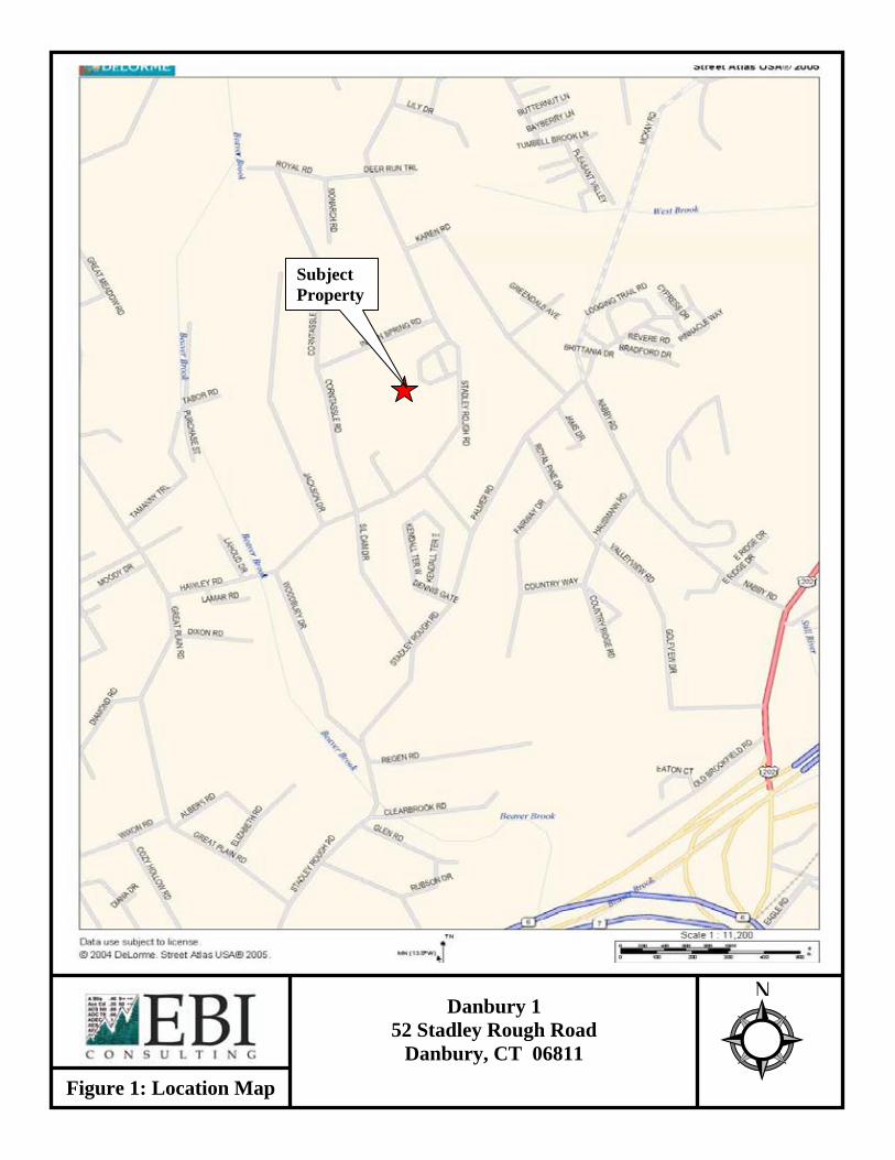
Figure 1: Location Map
Danbury 1 52 Stadley Rough Road
Danbury, CT 06811
Subject Property

Danbury 1 52 Stadley Rough Road
Danbury, CT 06811
A portion of the 1982 Danbury, CT USGS 7.5x15 Minute Quadrangle Scale 1:24,000
Figure 2: Locus Map
Subject Property

SITE PLAN
500 EN
TERPR
ISE D
RIVE
RO
CK
Y H
ILL, CO
NN
EC
TICU
T1(860)5298882
CAN
DLEW
OO
D BA
PTIST C
HU
RC
H52 STAD
LEY R
OU
GH
RO
ADD
AN
BU
RY
, CO
NN
ECTIC
UT
L1

COMPOUND PLAN
L2500 ENTERPRISE DRIVE
ROCKY HILL, CONNECTICUT1(860)5298882
CANDLEWOOD BAPTIST CHURCH52 STADLEY ROUGH ROADDANBURY, CONNECTICUT
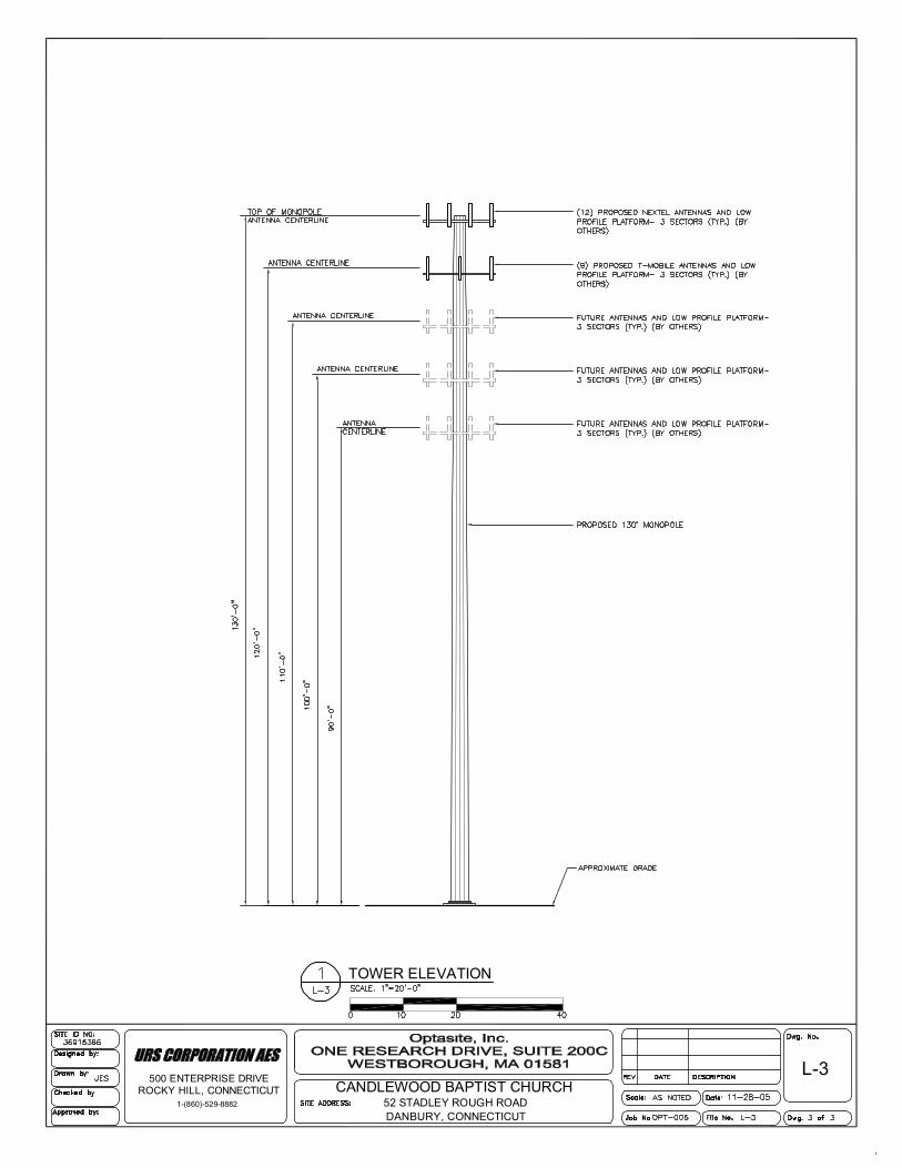
L3
TOWER ELEVATION
500 ENTERPRISE DRIVEROCKY HILL, CONNECTICUT
1(860)5298882
CANDLEWOOD BAPTIST CHURCH52 STADLEY ROUGH ROADDANBURY, CONNECTICUT

EBI Consulting
APPENDIX D SHPO CORRESPONDENCE


INTEGRATED HISTORIC PRESERVATION PLANNING January 18, 2006 Christine Keating EBI Consulting, Inc. Four A Street Burlington, MA 01803 RE: Preliminary Archeological Assessment of Telecommunications Tower on Stadley Rough
Road in Danbury, Connecticut Ms. Keating: Heritage Consultants, LLC, is pleased to have this opportunity to provide EBI Consulting, Inc., with the following preliminary archeological assessment of proposed telecommunications tower on Stadley Rough Road in Danbury, Connecticut (Figure 1). The current project entailed completion of an existing conditions cultural resources summary based on the examination of data provided by EBI Consulting, Inc.; GIS data obtained from the Connecticut State Historic Preservation Office; and historic maps, aerial photographs, and topographic quadrangles maintained by Heritage Consultants, LLC. This investigation did not consider the effects of the proposed construction upon built resources. The objectives of this study were: 1) to gather and present data regarding previously identified cultural resources situated within the vicinity of the Area of Potential Effect; 2) to investigate the proposed project parcel in terms of it natural and historical characteristics; and 3) to evaluate the need for completing additional cultural resources investigations. Environmental characteristics frequently are used to predict the location of archeological sites. Typically distance to water, slope, and soil types are included as part of these predictive models. A review of environmental characteristics identified in the vicinity of the proposed tower suggests that this location is favorable to past human settlement and landuse. The proposed tower location is situated in a gently sloping upland environment in the vicinity of several water sources. This type of environment often produces prehistoric task-specific and/or temporary camps. A review of previously recorded cultural resources on file with the Connecticut State Historic Preservation Office supports this statement; a total of four prehistoric/contact period archeological sites have been identified within 1.6 km (1.0 mi) of the proposed tower locations (Figure 2). Although no previously identified archeological sites or properties listed on the National Register of Historic Places are located within or immediately adjacent to the Area of Potential Effect, the lack of sites recorded within the immediate vicinity of the proposed tower likely is a result of it having never been subjected to systematic survey techniques.
877 Main Street • Newington, Connecticut
Phone (860) 667-3001 • Fax (860) 667-3008 Email: [email protected]
Figures 3 through 6 show that although the region surrounding the proposed tower may have been settled as early as the nineteenth century, the area encompassing the proposed tower site appears to have remained a rugged, outlying parcel throughout the historic era. Because only limited historic landuse and landscape modifications of the proposed project area has occurred, it is unlikely that a significant archeological site dating from the historic era is located within the proposed telecommunications facility.

Ms. Christine Keating January 18, 2006 Page 2
877 Main Street • Newington, Connecticut
Phone (860) 667-3001 • Fax (860) 667-3008 Email: [email protected]
In addition, the series of aerial photograph dating from 1934 through 2004 (Figures 7 through 11) also demonstrate that the area encompassing the proposed cell tower location has been only minimally impacted by historic and modern occupation and landuse. During the last quarter of the twentieth century, the Candlewood Baptist Church was constructed in the vicinity of the proposed project area. Current construction plans, however, depict the proposed telecommunications tower as being situated outside of the area impacted by the construction of the church. Therefore, because the proposed project area has the potential to yield intact prehistoric archeological sites and because this area does not appear to have been altered substantially by modern impacts, additional subsurface archeological investigation of the tower location is warranted to evaluate the effects of the proposed project. To determine whether or not intact subsurface cultural deposits exist within the proposed project area, Heritage Consultants, LLC anticipates that no more than twelve shovel tests would be needed to adequately examine proposed telecommunications tower on Stadley Rough Road in Danbury, Connecticut. If you have any questions regarding this Technical Memorandum, or if we may be of additional assistance with this or any other projects you may have, please do not hesitate to call us at 860-667-3001 or email us [email protected]. We are at your service. Sincerely, Catherine M. Labadia, M.A. President & Principal Investigator

Subject Property
600 1,200Meters
0
Figure 1. Excerpt from a recent USGS 7.5' series topographic map depicting the approximatelocation of cellular communications tower on Stadley Rough Road in Danbury,Connecticut.

Figure 2. Map of previously identified cultural resources situated in the vicinity of proposedcellular communications tower on Stadley Rough Road in Danbury, Connecticut.
East BkCedar Heights
Great Plain Bk
Snug Harbor
West BkTa'agan Point
Beaver Brook MountainPleasant Acres
Doyles Ice Pd Bk
Doyles Pd Beaver Bk
Smiths PdHayestownPenny & Ericson Bk
Kellners Pd
Candleview Ridge
L Wackawana
Still
R
Ston
y Hill
Bk
Cemetery Bk BeaverbrookCemetery Pd
Stony HillExit 5
Exit 6
Exit 7
Exit 8
84
6
6 7
37
7
34-434-3
18-26
34-11
Subject Property
0 1,200600Meters
1/2 Mile Buffer
Legend
Subject Property
Historic Site
Prehistoric Site
Rochambeau March Route 1782-1783
1/2 Mile Buffer
National Register (polygon)
Eberle Pd Day Cam
Scalzo Pd Day Camp Pd argerie ManorBear Mountain
Oppenheimer Pd
Aqua Vista
Subject Property
800 1,600Meters
0
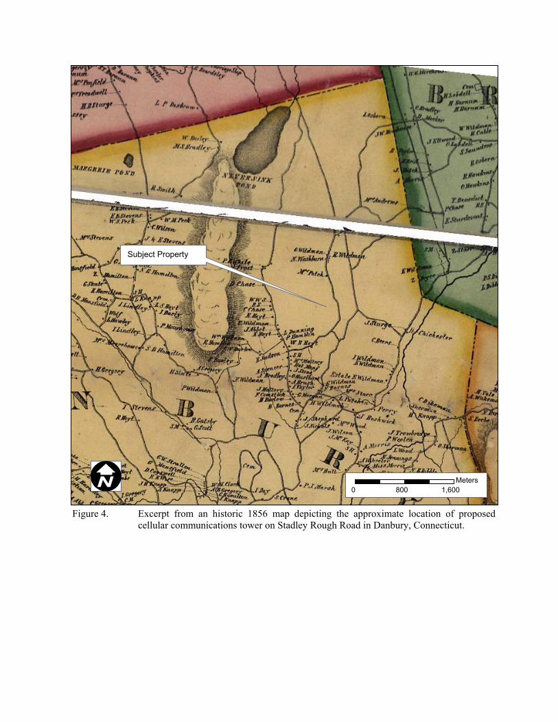
Figure 4. Excerpt from an historic 1856 map depicting the approximate location of proposedcellular communications tower on Stadley Rough Road in Danbury, Connecticut.

Subject Property
500 1,000Meters
0
Figure 4. Excerpt from an historic 1867 map depicting the approximate location of proposedcellular communications tower on Stadley Rough Road in Danbury, Connecticut.

Subject Property
400 800Meters
0
Figure 5. Excerpt from an historic 1931 map depicting the approximate location of proposedcellular communications tower on Stadley Rough Road in Danbury, Connecticut.

Subject Property
500 1,000Meters
0
Figure 6. Excerpt from the 1953 USGS 15’ series topographic quadrangle depicting theapproximate location of proposed telecommunications tower on Stadley Rough Road inDanbury, Connecticut.
Subject Property
180 360Meters
0
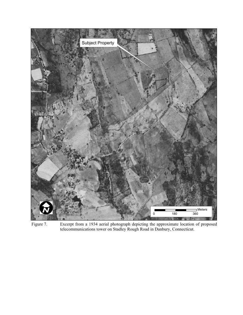
Figure 7. Excerpt from a 1934 aerial photograph depicting the approximate location of proposedtelecommunications tower on Stadley Rough Road in Danbury, Connecticut.

Subject Property
180 360Meters
0
Figure 8. Excerpt from a 1951 aerial photograph depicting the approximate location of proposedtelecommunications tower on Stadley Rough Road in Danbury, Connecticut.

Subject Property
212.5 425Meters
0
Figure 9. Excerpt from a 1972 aerial photograph depicting the approximate location of proposedtelecommunications tower on Stadley Rough Road in Danbury, Connecticut.

Subject Property
185 370Meters
0
Figure 10. Excerpt from a 1990 aerial photograph depicting the approximate location of proposedtelecommunications tower on Stadley Rough Road in Danbury, Connecticut.

Meters100 2000
Subject Property
Figure 11. Excerpt from a 2004 aerial photograph depicting the approximate location of proposedtelecommunications tower on Stadley Rough Road in Danbury, Connecticut.

ENVIROBUSINESS, INC. LOCATIONS | ATLANTA, GA | BALTIMORE, MD | BURLINGTON, MA | CHICAGO, IL | CRANSTON, RI | DALLAS, TX | DENVER, CO | EXETER, NH | HOUSTON, TX | LOS ANGELES, CA |
NEW YORK, NY | PHOENIX, AZ | PORTLAND, OR | SAN FRANCISCO, CA | SEATTLE, WA | YORK, PA
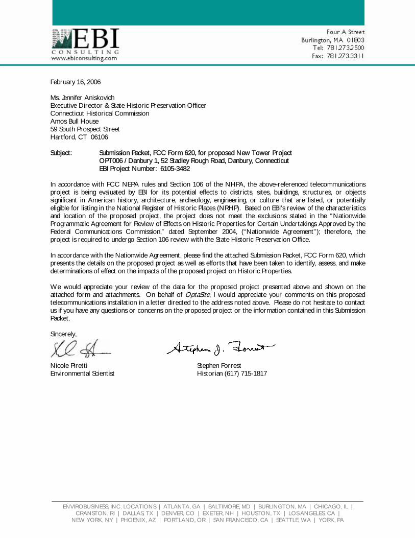
February 16, 2006 Ms. Jennifer Aniskovich Executive Director & State Historic Preservation Officer Connecticut Historical Commission Amos Bull House 59 South Prospect Street Hartford, CT 06106 Subject: Submission Packet, FCC Form 620, for proposed New Tower Project
OPT006 / Danbury 1, 52 Stadley Rough Road, Danbury, Connecticut EBI Project Number: 6105-3482
In accordance with FCC NEPA rules and Section 106 of the NHPA, the above-referenced telecommunications project is being evaluated by EBI for its potential effects to districts, sites, buildings, structures, or objects significant in American history, architecture, archeology, engineering, or culture that are listed, or potentially eligible for listing in the National Register of Historic Places (NRHP). Based on EBI’s review of the characteristics and location of the proposed project, the project does not meet the exclusions stated in the “Nationwide Programmatic Agreement for Review of Effects on Historic Properties for Certain Undertakings Approved by the Federal Communications Commission,” dated September 2004, (“Nationwide Agreement”); therefore, the project is required to undergo Section 106 review with the State Historic Preservation Office. In accordance with the Nationwide Agreement, please find the attached Submission Packet, FCC Form 620, which presents the details on the proposed project as well as efforts that have been taken to identify, assess, and make determinations of effect on the impacts of the proposed project on Historic Properties. We would appreciate your review of the data for the proposed project presented above and shown on the attached form and attachments. On behalf of OptaSite, I would appreciate your comments on this proposed telecommunications installation in a letter directed to the address noted above. Please do not hesitate to contact us if you have any questions or concerns on the proposed project or the information contained in this Submission Packet. Sincerely, Nicole Piretti Stephen Forrest Environmental Scientist Historian (617) 715-1817

NT SUBMISSION PACKET – FCC FORM 620
Approved by OMB 3060-1039
Estimated Time Per Response: .5 to 10 hours
Applicant’s Name: OptaSite
Project Name: Danbury 1 Project Number: EBI # 6105-3482 Page 1
FCC Form 620 January 2005
New Tower (“NT”) Submission Packet
FCC FORM 620
Introduction The NT Submission Packet is to be completed by or on behalf of Applicants to construct new antenna support structures by or for the use of licensees of the Federal Communications Commission (“FCC”). The Packet (including Form 620 and attachments) is to be submitted to the State Historic Preservation Office (“SHPO”) or to the Tribal Historic Preservation Office (“THPO”), as appropriate, before any construction or other installation activities on the site begin. Failure to provide the Submission Packet and complete the review process under Section 106 of the National Historic Preservation Act (“NHPA”)1 prior to beginning construction may violate Section 110(k) of the NHPA and the Commission’s rules. The instructions below should be read in conjunction with, and not as a substitute for, the “Nationwide Programmatic Agreement for Review of Effects on Historic Properties for Certain Undertakings Approved by the Federal Communications Commission,” dated September 2004, (“Nationwide Agreement”) and the relevant rules of the FCC (47 C.F.R. §§ 1.1301-1.1319) and the Advisory Council on Historic Preservation (“ACHP”) (36 C.F.R. Part 800).2 Exclusions and Scope of Use The NT Submission Packet should not be submitted for undertakings that are excluded from Section 106 Review. The categories of new tower construction that are excluded from historic preservation review under Section 106 of the NHPA are described in Section III of the Nationwide Agreement. Where an undertaking is to be completed but no submission will be made to a SHPO or THPO due to the applicability of one or more exclusions, the Applicant should retain in its files documentation of the basis for each exclusion should a question arise as to the Applicant’s compliance with Section 106. The NT Submission Packet is to be used only for the construction of new antenna support structures. Antenna collocations that are subject to Section 106 review should be submitted using the Collocation (“CO”) Submission Packet (FCC Form 621).
1 16 U.S.C. § 470f.
2 Section II.A.9. Of the Nationwide Agreement defines a “historic property” as: “Any prehistoric or historic district, site, building, structure, or object included in, or eligible for inclusion in, the National Register maintained by the Secretary of the Interior. This term includes artifacts, records, and remains that are related to and located within such properties. The term includes properties of traditional religious and cultural importance to an Indian tribe or Native Hawaiian Organization that meet the National Register criteria.”

NT SUBMISSION PACKET – FCC FORM 620
Approved by OMB 3060-1039
Estimated Time Per Response: .5 to 10 hours
Applicant’s Name: OptaSite
Project Name: Danbury 1 Project Number: EBI # 6105-3482 Page 2
FCC Form 620 January 2005
General Instructions: NT Submission Packet Fill out the answers to Questions 1-5 on Form 620 and provide the requested attachments. Attachments should be numbered and provided in the order described below. For ease of processing, provide the Applicant’s Name, Applicant’s Project Name, and Applicant’s Project Number in the lower right hand corner of each page of Form 620 and attachments.3 1. Applicant Information Full Legal Name of Applicant: Optasite Name and Title of Contact Person: Keith Coppins Address of Contact Person (including Zip Code): One Research Drive, Suite 200C, Westborough, Massachusetts 01581 Phone: (508) 799-2460 (ext 314) Fax: E-mail address: [email protected] 2. Applicant's Consultant Information Full Legal Name of Applicant's Section 106 Consulting Firm: EnviroBusiness Inc. d/b/a EBI Consulting Name of Principal Investigator: Stephen Forrest Title of Principal Investigator: Historian Investigator’s Address: Four A Street City: Burlington State: MA Zip Code 01803 Phone: (617) 715-1817 Fax: (617) 715-6597 E-mail Address: [email protected]
3 Some attachments may contain photos or maps on which this information cannot be provided.

NT SUBMISSION PACKET – FCC FORM 620
Approved by OMB 3060-1039
Estimated Time Per Response: .5 to 10 hours
Applicant’s Name: OptaSite
Project Name: Danbury 1 Project Number: EBI # 6105-3482 Page 3
FCC Form 620 January 2005
Does the Principal Investigator satisfy the Secretary of the Interior’s Professional Qualification Standards?4 YES Areas in which the Principal Investigator meets the Secretary of the Interior’s Professional Qualification Standards: Historian Other “Secretary of the Interior qualified” staff who worked on the Submission Packet (provide name(s) as well as well as the area(s) in which they are qualified):
Heritage Consultants, LLC – Cultural Resource Consulting Firm
3. Site Information a. Street Address of Site: 52 Stadley Rough Road
City or Township: Danbury County / Parish: Fairfield State: CT Zip Code:
b. Nearest Cross Roads: Stadley Rough Road (also Hawley Rd) / Indian Spring Road c. NAD 83 Latitude/Longitude coordinates (to tenth of a second):
N 41° 25’ 47”; W 73° 25’ 50 ”
d. Proposed tower height above ground level:5 130 feet; e. Tower type:
Guyed lattice tower self-supporting lattice monopole
Other (briefly describe tower)
4 The Professional Qualification Standards are available on the cultural resources webpage of the National Park Service, Department of the Interior: <http://www.cr.nps.gov/local-law/arch_stnds_9.htm>. The Nationwide Agreement requires use of Secretary-qualified professionals for identification and evaluation of historic properties within the APE for direct effects, and for assessment of effects. The Nationwide Agreement encourages, but does not require, use of Secretary-qualified professionals to identify historic properties within the APE for indirect effects. See Nationwide Agreement, §§ VI.D.1.d, VI.D.1.e, VI.D.2.b, VI.E.5.
5 Include top-mounted attachments such as lightning rods.

NT SUBMISSION PACKET – FCC FORM 620
Approved by OMB 3060-1039
Estimated Time Per Response: .5 to 10 hours
Applicant’s Name: OptaSite
Project Name: Danbury 1 Project Number: EBI # 6105-3482 Page 4
FCC Form 620 January 2005
4. Project Status:6
a. Construction not yet commenced; b. Construction commenced on [date] ; or, c. Construction commenced on [date] and was completed on [date] 5. Applicant’s Determination of Effect: a. Direct Effects (check one):
i. No Historic Properties in Area of Potential Effects (“APE”) for direct effects; ii. “No effect” on Historic Properties in APE for direct effects; iii. “No adverse effect” on Historic Properties in APE for direct effects; iv. “Adverse effect” on one or more Historic Properties in APE for direct effects.
b. Visual Effects (check one):
i. No Historic Properties in Area of Potential Effects (“APE”) for visual affects; ii. “No effect” on Historic Properties in APE for visual effects; iii. “No adverse effect” on Historic Properties in APE for visual effects; iv. “Adverse effect” on one or more Historic Properties in APE for visual effects.
Certification and Signature
I certify that all representations on this FCC Form 620 and the accompanying attachments are true, correct, and complete. February 16, 2006 Signature Date Stephen Forrest Historian
Printed Name Title WILLFUL FALSE STATEMENTS MADE ON THIS FORM OR ANY ATTACHMENTS ARE PUNISHABLE BY FINE AND/OR IMPRISONMENT (U.S. Code, Title 18, Section 1001) AND/OR REVOCATION OF ANY STATION LICENSE OR CONSTRUCTION PERMIT (U.S. Code, Title 47, Section 312(a)(1) AND/ OR FORFEITURE (U.S. Code, Title 47, Section 503).
6 Failure to provide the Submission Packet and complete the review process under Section 106 of the NHPA prior to beginning construction may violate Section 110(k) of the NHPA and the Commission’s rules. See Section X of the Nationwide Agreement.

NT SUBMISSION PACKET – FCC FORM 620
Approved by OMB 3060-1039
Estimated Time Per Response: .5 to 10 hours
FCC Form 620 January 2005
Attachments
Provide the following attachments in this order and numbered as follows: Attachment 1. Résumés / Vitae. Provide a current copy of the résumé or curriculum vitae for the Principal Investigator and any researcher or other person who contributed to, reviewed, or provided significant input into the research, analysis, writing or conclusions presented in the Submission Packet for this proposed collocation.
Please see attached Resumes of Principal Investigator and other contributing personnel.

EBI CONSULTING Nicole Piretti Environmental Scientist
SUMMARY OF EXPERIENCE Ms. Piretti is an environmental scientist specializing in environmental investigations, site assessments, health and safety compliance and NEPA environmental reviews for the telecommunications industry. Ms. Piretti has conducted numerous environmental pre-acquisition assessments/due diligence assignments for a wide range of properties throughout the Northeast. These assessments have been performed to evaluate site conditions, potential off-site liabilities, historic site and vicinity usage, environmental control systems, and site remediation costs in order to advise prospective buyers, current operators, and owners of potential and existing environmental concerns. RELEVANT PROJECT EXPERIENCE
Environmental Site Assessments. Ms. Piretti has conducted ASTM Phase I Environmental Site Assessments and Preliminary Environmental Site Screenings for a variety of properties located within the New York area. These properties have included commercial, retail and multi-family residential properties, as well as telecommunications sites. ASTM investigations include correspondence and evaluations with federal, state, and local government offices. Mobile Telecommunication Site Assessments. In addition to environmental assessments, Ms. Piretti prepares and manages NEPA reviews and Environmental Assessments for telecommunications sites throughout the Northeast. Ms. Piretti has helped clients facilitate the environmental review process to ensure compliance with Federal Communications Commission (FCC) requirements under the National Environmental Policy Act (NEPA). Environmental reviews include analysis of historic properties, wetlands, endangered species habitat, floodplains, and other areas of environmental concern and the possible impacts of cellular installations on these sensitive areas.
EDUCATION Master’s Degree – Environmental Science: Resource Management
CW Post University September, 2002 Bachelor’s Degree – Environmental Science
Binghamton University May, 1997
PROFESSIONAL TRAINING AND CERTIFICATIONS Asbestos Inspector 40-Hour HAZWOPER Health and Safety Training Lead Based Paint Risk Assessor/Inspector (valid in NY, NJ, FL)

EBI CONSULTING Stephen Forrest Environmental Scientist
SUMMARY OF EXPERIENCE Stephen Forrest is a Environmental Scientist specializing in environmental investigations, site assessments, and NEPA environmental reviews for the telecommunications industry. Mr. Forrest has conducted numerous environmental due diligence assignments for a wide range of properties throughout the New England region. These assessments have been performed to evaluate site conditions, potential off-site liabilities, historic site and vicinity usage, environmental control systems, and site remediation costs in order to advise prospective buyers, current operators, and owners of potential and existing environmental concerns. RELEVANT PROJECT EXPERIENCE
Environmental Site Assessments: Mr. Forrest has successfully completed ASTM Phase I Site Assessments and Preliminary Environmental Site Screenings for a variety of properties located within the New England area. These assessments have been performed to evaluate site conditions, potential off-site liabilities, environmental control systems, and site remediation costs in order to advise prospective buyers, current operators, and owners of potential and existing environmental concerns. These properties have included industrial, commercial, multi-family residential and mobile telecommunications properties. NEPA Assessments: In addition to environmental assessments, Mr. Forrest prepares and manages NEPA reviews and Environmental Assessments for telecommunications sites throughout the New England area. Mr. Forrest has helped clients facilitate the environmental review process to ensure compliance with Federal Communications Commission (FCC) requirements under the National Environmental Policy Act (NEPA). Environmental reviews include analysis of historic properties, wetlands, endangered species habitat, floodplains, and other areas of environmental concern and the possible impacts of telecommunications installations on these sensitive areas. EDUCATION Bachelor’s Degree History/Political Science Villanova University, Villanova, PA

NT SUBMISSION PACKET – FCC FORM 620
Approved by OMB 3060-1039
Estimated Time Per Response: .5 to 10 hours
FCC Form 620 January 2005
Attachment 2. Additional Site Information Describe any additional structures, access roads, utility lines, fences, easements, or other construction planned for the site in conjunction with the proposed facility
The Subject Property consists of an approximately 5.2-acre lot that is improved with a church building, located towards the northeast quadrant of the Property. The church was constructed in 1972 and has always been occupied by the Candlewood Baptist Church. The Project Site is located in the area of undeveloped woodland in the southwest quadrant of Subject Property.
Optasite proposes to construct a tower facility on the southwestern portion of the Subject Property. The tower facility will include a 130-foot monopole tower located within a fenced 50 x 90 foot gravel compound. Equipment shelters, antenna arrays, and applicable conduits will be constructed separately by outside carriers (Nextel, T-Mobile, and others are proposed). A pad mounted transformer and multi-meter center will be located at the northeastern corner of the tower compound. Optasite plans to improve a 12-foot wide by 80-foot long gravel access road with underground utilities from the existing western access drive of the church to the tower area. Please refer to the Site Plans for the proposed project, which are included in Attachment 12, Maps.
Attachment 3. Tribal and NHO Involvement At an early stage in the planning process, the Nationwide Agreement requires the Applicant to gather information from appropriate Indian Tribes or Native Hawaiian Organizations (“NHOs”) to assist in the identification of historic properties of religious and cultural significance to them. Describe measures taken to identify Indian tribes and NHOs that may attach religious and cultural significance to historic properties that may be affected by the undertaking within the Areas of Potential Effects (“APE”) for direct and visual effects. If such Indian tribes or NHOs were identified, list them and provide a summary of contacts by either the FCC, the Applicant, or the Applicant’s representative. Provide copies of relevant documents, including correspondence. If no such Indian tribes or NHOs were identified, please explain.
EBI completed the Tower Construction Notification System (TCNS) on January 13, 2006. The attached FCC Notification email lists the Tribes identified through the TCNS process. Follow up correspondence, as necessary, will be completed via the methods listed on the attached email considered acceptable to that Tribe.

Nicole Piretti
From: <[email protected]>To: <[email protected]>Cc: <[email protected]>; <[email protected]>Sent: Friday, January 13, 2006 3:01 AMSubject: NOTICE OF ORGANIZATION(S) WHICH WERE SENT PROPOSED TOWER CONSTRUCTION
NOTIFICATION INFORMATION - Email ID #925312
Page 1 of 4
2/8/2006
Dear Sir or Madam: Thank you for using the Federal Communications Commission's (FCC) Tower Construction Notification System (TCNS). The purpose of this electronic mail message is to inform you that the following authorized persons were sent the information you provided through TCNS, which relates to your proposed antenna structure. The information was forwarded by the FCC to authorized TCNS users by electronic mail and/or regular mail (letter). Persons who have received this information include leaders or their designees of federally-recognized American Indian Tribes, including Alaska Native Villages (collectively "Tribes"), Native Hawaiian Organizations (NHOs), and State and Tribal Historic Preservation Officers (SHPOs and THPOs). For your convenience in identifying the referenced Tribes and in making further contacts, the City and State of the Seat of Government for each Tribe and NHO is included in the listing below. We note that Tribes may have Section 106 cultural interests in ancestral homelands or other locations that are far removed from their current Seat of Government. The information you provided was forwarded to the following Tribes, NHOs, SHPOs, and THPOs who have set their geographic preferences on TCNS. If the information you provided relates to a proposed antenna structure in the State of Alaska, the following list also includes Tribes located in the State of Alaska that have not specified their geographic preferences: 1. THPO - Kathleen Knowles - Mashantucket Pequot Tribe - Mashantucket, CT - electronic mail Exclusions: For every tower construction this Tribe requires a site location map, site plans for every project that will result in ground disturbance, and a detailed description of the proposed site. If the proposed tower construction is on an already existing building, the Tribe would like to be informed of that as well. 2. Deputy THPO - Doug Harris - Narragansett Indian Tribe - Wyoming, RI - electronic mail and regular mail 3. SHPO - John Shannahan - Connecticut Historical Commission - Hartford, CT - electronic mail 4. SHPO - Cara Metz - Massachusetts Historical Commission - Boston, MA - electronic mail 5. Deputy SHPO - Brona Simon - Massachusetts Historical Commission - Boston, MA - electronic mail 6. SHPO - Bernadette Castro - Parks, Recreation & Historic Preservation - Albany, NY - regular mail 7. Director - Ruth Pierpont - Bureau of Field Services, NY State Parks &* Hist. Pres. - Waterford, NY - electronic mail

8. SHPO - Frederick Williamson - Rhode Island Historic Preservation & Heritage Comm - Providence, RI - regular mail 9. Deputy SHPO - Edward Sanderson - Rhode Island Historic Preservation & Heritage Comm - Providence, RI - electronic mail The information you provided was also forwarded to the additional Tribes and NHOs listed below. These Tribes and NHOs have NOT set their geographic preferences on TCNS, and therefore they are currently receiving tower notifications for the entire United States: 10. Governor - Ruben Romero - Pueblo of Taos - Taos, NM - regular mail 11. Chairman - Jeff Houser - Fort Sill Apache Tribe of Oklahoma - Apache, OK - regular mail 12. Chairman - Rex Tilousi - Havasupai Tribal Council - Supai, AZ - regular mail 13. Chairman - Alfred Happy - Lovelock Paiute Tribe - Lovelock, NV - regular mail 14. President - Johnny Lehi - San Juan Southern Paiute Council - Tuba City, AZ - regular mail 15. Tribal Administrator - Morey BlackEagle - Suquamish Tribal Council - Suquamish, WA - regular mail 16. Chairperson - Marilyn Scott - Upper Skagit Tribal Council - Sedro Woolley, WA - regular mail 17. Spokesperson - Christina Arzate - Santa Rosa Band of Mission Indians - Hemet, CA - regular mail 18. Environmental Coordinator - Wilfred Nabahe - Lone Pine Paiute Shoshone Reservation - Lone Pine, CA - electronic mail 19. Chairman - Daniel Beltran - Lower Lake Rancheria - Oakland, CA - regular mail "Exclusions" above refer to types of tower notifications that the Tribe, NHO, SHPO, or THPO has stated it does not wish to review. TCNS automatically forwards all notifications to all Tribes, NHOs, SHPOs, and THPOs that have an expressed interest in the geographic area of a proposal, as well as Tribes and NHOs that have not limited their geographic areas of interest. However, if a proposal falls within a designated exclusion, you need not expect any response and need not pursue any additional process with that Tribe, NHO, SHPO, or THPO. Pursuant to the Commission's rules as set forth in the Nationwide Programmatic Agreement for Review of Effects on Historic Properties for Certain Undertakings Approved by the Federal Communications Commission (NPA), all Tribes and NHOs listed above must be afforded a reasonable opportunity to respond to this notification, unless the proposed construction falls within an exclusion designated by the Tribe or NHO. (NPA, Section IV.F.4). For those Tribes and NHOs that have specified an interest in the geographic area of a proposed construction, if the Tribe or NHO fails to respond within a reasonable time, you should make a reasonable effort at follow-up contact, unless the Tribe or NHO has agreed to
Page 2 of 4
2/8/2006

different procedures (NPA, Section IV.F.5). In the event such a Tribe or NHO does not respond to a follow-up inquiry, or if a substantive or procedural disagreement arises between you and a Tribe or NHO, you must seek guidance from the Commission (NPA, Section IV.G). For those Tribes and NHOs that have not designated their geographic areas of interest through TCNS, you are required to use reasonable and good faith efforts to determine if the Tribe or NHO may attach religious and cultural significance to historic properties that may be affected by its proposed undertaking. Such efforts may include, but are not limited to, seeking information from the relevant SHPO or THPO, Indian Tribes, state agencies, the U.S. Bureau of Indian Affairs, or, where applicable, any federal agency with land holdings within the state (NPA, Section IV.B). If after such reasonable and good faith efforts, you determine that a Tribe or NHO may attach religious and cultural significance to historic properties in the area and the Tribe or NHO does not respond to TCNS notification within a reasonable time, you should make a reasonable effort to follow up, and must seek guidance from the Commission in the event of continued non-response or in the event of a procedural or substantive disagreement. If you determine that the Tribe or NHO is unlikely to attach religious and cultural significance to historic properties within the area, you do not need to take further action unless the Tribe or NHO indicates an interest in the proposed construction or other evidence of potential interest comes to your attention. If you are proposing to construct a facility in the State of Alaska, you should contact Commission staff for guidance regarding your obligations in the event that Tribes do not respond to this notification within a reasonable time. Please be advised that the FCC cannot guarantee that the contact(s) listed above opened and reviewed an electronic or regular mail notification. The following information relating to the proposed tower was forwarded to the person(s) listed above: Notification Received: 01/07/2006 Notification ID: 10967 Entity Name: Optasite Individual or Contact Name: Nicole Piretti Street Address: EBI Consulting Four A Street City: Burlington State: MASSACHUSETTS Zip Code: 01803 Phone: 631-321-1076 Email: [email protected] Structure Type: POLE - Any type of Pole Latitude: 73 deg 25 min 50.0 sec N Longitude: 41 deg 25 min 47.0 sec W Location Description: 52 Stadley Rough Road City: Danbury State: CONNECTICUT County: Ground Elevation: 166.1 meters Support Structure: 54.9 meters above ground level Overall Structure: 54.9 meters above ground level Overall Height AMSL: 222.5 meters above mean sea level If you have any questions or comments regarding this notice, please contact the FCC using the electronic mail form located on the FCC's website at:
Page 3 of 4
2/8/2006

http://wireless.fcc.gov/outreach/notification/contact-fcc.html. If you prefer, you may contact the FCC's Universal Licensing System (ULS) hotline by telephone at (717) 338-2888, or toll free at (877) 480-3201. When prompted by the FCC operator, please select Option #2. Thank you, Federal Communications Commission
Page 4 of 4
2/8/2006

NT SUBMISSION PACKET – FCC FORM 620
Approved by OMB 3060-1039
Estimated Time Per Response: .5 to 10 hours
FCC Form 620 January 2005
Attachment 4. Local Government a. Has any local government agency been contacted and invited to become a consulting party pursuant to
Section V.A. of the Nationwide Agreement? If so, list the local government agencies contacted. Provide a summary of contacts and copies of any relevant documents (e.g., correspondence or notices).
The City Clerk of the City of Danbury, CT has been notified of the proposed project and has been invited to indicate whether they are interested in consulting further on the proposed project. A copy of the notice sent to the local government office is attached.
b. If a local government agency will be contacted but has not been to date, explain why and when such contact
will take place. N/A

January 17, 2006 Ms. Jean Natale, Clerk City of Danbury 155 Deer Hill Avenue Danbury, CT 06810 Subject: Invitation to Comment in Section 106 Consultation Process
Danbury 1 / OPT006 52 Stadley Rough Road, Danbury, CT EBI Project #6105-3482
Dear Ms. Natale: In accordance with FCC NEPA rules and Section 106 of the NHPA, the above-referenced telecommunications project is being evaluated by EBI for its potential effects to districts, sites, buildings, structures, or objects significant in American history, architecture, archeology, engineering, or culture that are listed, or potentially eligible for listing in the National Register of Historic Places (NRHP). Based on EBI’s review of the characteristics and location of the proposed project, the project does not meet the exclusions stated in the “Nationwide Programmatic Agreement for Review of Effects on Historic Properties for Certain Undertakings Approved by the Federal Communications Commission,” dated September 2004, (“Nationwide Agreement”); therefore, the project is required to undergo Section 106 review with the State Historic Preservation Office. This letter is to invite the City of Danbury to review Optasite’s plans for a proposed telecommunications facility to be located at the address noted above. Optasite’s new facility will consist of a 130-foot monopole style telecommunications tower within a 90-foot by 50-foot fenced gravel compound on the southwestern portion of the Subject Property. Additional antenna arrays and ground-level equipment shelters have been proposed for construction separately within the fenced compound by outside carriers. Utility conduits will be routed underground, and a proposed access drive will be extended from the existing facility driveway to the tower compound. On behalf of Optasite, we are inviting comment on the project’s potential effects to districts, sites, buildings, structures, or objects significant in American history, architecture, archeology, engineering, or culture that are listed, or potentially eligible for listing in the NRHP. We would appreciate any comments you wish to provide regarding the potential effects of the proposed facility on any historic property in a letter directed to the address noted above within the next 30 days. Please do not hesitate to contact us if you have any questions or concerns on the proposed project. Respectfully Submitted,
Nicole Piretti Environmental Scientist (781) 552-9278
ENVIROBUSINESS, INC. LOCATIONS | ATLANTA, GA | BALTIMORE, MD | BURLINGTON, MA | CHICAGO, IL | CRANSTON, RI | DALLAS, TX | DENVER, CO | EXETER, NH | HOUSTON, TX | LOS ANGELES, CA |
NEW YORK, NY | PHOENIX, AZ | PORTLAND, OR | SAN FRANCISCO, CA | SEATTLE, WA | YORK, PA

NT SUBMISSION PACKET – FCC FORM 620
Approved by OMB 3060-1039
Estimated Time Per Response: .5 to 10 hours
FCC Form 620 January 2005
Attachment 5. Public Involvement Describe measures taken to obtain public involvement in this project (e.g., notices, letters, or public meetings). Provide copies of relevant documentation.
Attached please find a copy of the legal notice regarding the proposed telecommunications installation that was posted in The News-Times on January 22, 2006. As of the date of this letter, no comments regarding this notice have been received by either EBI or the Applicant. Should a response be received, copies will be forwarded as an addendum to this submission packet.


NT SUBMISSION PACKET – FCC FORM 620
Approved by OMB 3060-1039
Estimated Time Per Response: .5 to 10 hours
FCC Form 620 January 2005
Attachment 6. Additional Consulting Parties List additional consulting parties that were invited to participate by the Applicant, or independently requested to participate. Provide any relevant correspondence or other documents.
No additional Consulting Parties have been invited to date.
NT SUBMISSION PACKET – FCC FORM 620
Approved by OMB 3060-1039
Estimated Time Per Response: .5 to 10 hours
FCC Form 620 January 2005
Attachment 7. Areas of Potential Effects a. Describe the APE for direct effects and explain how this APE was determined.
Because the Subject Property consists of a mix of modern development and woodland, only those portions of the Subject Property where ground disturbance will take place are regarded as within the APE for Direct Effects. The area of ground disturbance includes the portions of the property to be excavated for the tower compound, access road and utility run. These areas have been described in Attachment 2. Please note that a proposed tower foundation typically extends approximately zero to 30 feet below grade. Additionally, the proposed equipment shelters, access road, and utility runs typically extend up to a depth of four feet below grade.
b. Describe the APE for visual effects and explain how this APE was determined.
The APE for visual effects is the geographic area in which the Undertaking has the potential to introduce visual elements that diminish or alter the setting, including the landscape, where the setting is a character-defining feature of a Historic Property that makes it eligible for listing on the National Register. The presumed APE for visual effects for construction of new Facilities is the area from which the Tower will be visible, which is within a half mile from the tower site as the proposed Tower is 200 feet or less in overall height. Based upon EBI’s walkover and windshield survey of the proposed Project Site and vicinity, as well as a review of appropriate topographic maps, and the general development of the project area, the tower, or portions thereof, has the potential to be visible from areas within the presumed APE. Due to the mix of dense forestation and the pattern of modern development in the immediate area, the tower will only be visible from portions of Stadley Rough Road directly east of the Subject Property, as well as portions of the residences located to the west and north of the Subject Property.

NT SUBMISSION PACKET – FCC FORM 620
Approved by OMB 3060-1039
Estimated Time Per Response: .5 to 10 hours
FCC Form 620 January 2005
Attachment 8. Historic Properties Identified in the APE for Visual Effects a. Provide the name and address (including U.S. Postal Service ZIP Code) of each property in the APE for visual
effects that is listed in the National Register, has been formally determined eligible for listing by the Keeper of the National Register, or is identified as considered eligible for listing in the records of the SHPO/THPO, pursuant to Section VI.D.1.a. of the Nationwide Agreement.7
Based on EBI’s review of files at the Connecticut State Office of Historic Preservation on January 15, 2006, no Historic Properties were identified within the APE for visual effects.
b. Provide the name and address (including U.S. Postal Service ZIP Code) of each Historic Property in the APE
for visual effects, not listed in Attachment 8a, identified through the comments of Indian Tribes, NHOs, local governments, or members of the public. Identify each individual or group whose comments led to the inclusion of a Historic Property in this attachment. For each such property, describe how it satisfies the criteria of eligibility (36 C.F.R. Part 63).
No additional Historic Properties have been identified.
c. For any properties listed on Attachment 8a that the Applicant considers no longer eligible for inclusion in the
National Register, explain the basis for this recommendation. No Historic Properties were referenced above in 8a.
7 Section VI.D.1.a. of the Nationwide Agreement requires the Applicant to review publicly available records to identify within the APE for visual effects: i) properties listed in the National Register; ii) properties formally determined eligible for listing by the Keeper of the National Register; iii) properties that the SHPO/THPO certifies are in the process of being nominated to the National Register; iv) properties previously determined eligible as part of a consensus determination of eligibility between the SHPO/THPO and a Federal Agency or local government representing the Department of Housing and Urban Development (HUD); and, v) properties listed in the SHPO/THPO Inventory that the SHPO/THPO has previously evaluated and found to meet the National Register criteria, and that are identified accordingly in the SHPO/THPO Inventory.

NT SUBMISSION PACKET – FCC FORM 620
Approved by OMB 3060-1039
Estimated Time Per Response: .5 to 10 hours
FCC Form 620 January 2005
Attachment 9. Historic Properties Identified in the APE for Direct Effects a. List all properties identified in Attachment 8a or 8b that are within the APE for direct effects.
Based on EBI’s review of files at the Connecticut State Office of Historic Preservation on January 15, 2006, no Historic Properties were identified within the APE for direct effects.
b. Provide the name and address (including U.S. Postal Service ZIP Code) of each property in the APE for direct effects, not listed in Attachment 9a, that the Applicant considers to be eligible for listing in the National Register as a result of the Applicant’s research. For each such property, describe how it satisfies the criteria of eligibility (36 C.F.R. Part 63). For each property that was specifically considered and determined not to be eligible, describe why it does not satisfy the criteria of eligibility.
No additional Historic Properties have been identified.
c. Describe the techniques and the methodology, including any field survey, used to identify historic properties
within the APE for direct effects.8 If no archeological field survey was performed, provide a report substantiating that: i) the depth of previous disturbance exceeds the proposed construction depth (excluding footings and other anchoring mechanisms) by at least 2 feet; or, ii) geomorphological evidence indicates that cultural resource-bearing soils do not occur within the project area or may occur but at depths that exceed 2 feet below the proposed construction depth.9
EBI contracted Heritage Consultants, LLC to perform an evaluation of the proposed Project Site for the likelihood of containing archaeological resources. The evaluation for archaeological resources included a review of project plans and an evaluation of land features and documented historic and archaeological sites in the vicinity to determine the likelihood of resources being present in areas to be disturbed by OptaSite. Please see the attached Report documenting the findings of this project review by a qualified archaeologist. This report concludes that although the Subject Property has been developed by the existing church building and associated parking, the Project Site is situated outside of the areas impacted by this development (or other modern impacts), and as such, there is the potential for the site to yield intact prehistoric archaeological sites, thus warranting further investigation. The report indicates that no more than twelve (12) shovel digs would likely be necessary to confirm the presence of such resources .
8 Pursuant to Section VI.D.2.a. of the Nationwide Agreement, Applicants shall make a reasonable and good faith effort to identify above ground and archeological historic properties, including buildings, structures, and historic districts, that lie within the APE for direct effects. Such reasonable and good faith efforts may include a field survey where appropriate.
9 Under Section VI.D.2.d. of the Nationwide Agreement, an archeological field survey is required even if none of these conditions applies, if an Indian tribe or NHO provides evidence that supports a high probability of the presence of intact archeological Historic Properties within the APE for direct effects.

INTEGRATED HISTORIC PRESERVATION PLANNING January 18, 2006 Christine Keating EBI Consulting, Inc. Four A Street Burlington, MA 01803 RE: Preliminary Archeological Assessment of Telecommunications Tower on Stadley Rough
Road in Danbury, Connecticut Ms. Keating: Heritage Consultants, LLC, is pleased to have this opportunity to provide EBI Consulting, Inc., with the following preliminary archeological assessment of proposed telecommunications tower on Stadley Rough Road in Danbury, Connecticut (Figure 1). The current project entailed completion of an existing conditions cultural resources summary based on the examination of data provided by EBI Consulting, Inc.; GIS data obtained from the Connecticut State Historic Preservation Office; and historic maps, aerial photographs, and topographic quadrangles maintained by Heritage Consultants, LLC. This investigation did not consider the effects of the proposed construction upon built resources. The objectives of this study were: 1) to gather and present data regarding previously identified cultural resources situated within the vicinity of the Area of Potential Effect; 2) to investigate the proposed project parcel in terms of it natural and historical characteristics; and 3) to evaluate the need for completing additional cultural resources investigations. Environmental characteristics frequently are used to predict the location of archeological sites. Typically distance to water, slope, and soil types are included as part of these predictive models. A review of environmental characteristics identified in the vicinity of the proposed tower suggests that this location is favorable to past human settlement and landuse. The proposed tower location is situated in a gently sloping upland environment in the vicinity of several water sources. This type of environment often produces prehistoric task-specific and/or temporary camps. A review of previously recorded cultural resources on file with the Connecticut State Historic Preservation Office supports this statement; a total of four prehistoric/contact period archeological sites have been identified within 1.6 km (1.0 mi) of the proposed tower locations (Figure 2). Although no previously identified archeological sites or properties listed on the National Register of Historic Places are located within or immediately adjacent to the Area of Potential Effect, the lack of sites recorded within the immediate vicinity of the proposed tower likely is a result of it having never been subjected to systematic survey techniques.
877 Main Street • Newington, Connecticut
Phone (860) 667-3001 • Fax (860) 667-3008 Email: [email protected]
Figures 3 through 6 show that although the region surrounding the proposed tower may have been settled as early as the nineteenth century, the area encompassing the proposed tower site appears to have remained a rugged, outlying parcel throughout the historic era. Because only limited historic landuse and landscape modifications of the proposed project area has occurred, it is unlikely that a significant archeological site dating from the historic era is located within the proposed telecommunications facility.
Ms. Christine Keating January 18, 2006 Page 2
877 Main Street • Newington, Connecticut
Phone (860) 667-3001 • Fax (860) 667-3008 Email: [email protected]
In addition, the series of aerial photograph dating from 1934 through 2004 (Figures 7 through 11) also demonstrate that the area encompassing the proposed cell tower location has been only minimally impacted by historic and modern occupation and landuse. During the last quarter of the twentieth century, the Candlewood Baptist Church was constructed in the vicinity of the proposed project area. Current construction plans, however, depict the proposed telecommunications tower as being situated outside of the area impacted by the construction of the church. Therefore, because the proposed project area has the potential to yield intact prehistoric archeological sites and because this area does not appear to have been altered substantially by modern impacts, additional subsurface archeological investigation of the tower location is warranted to evaluate the effects of the proposed project. To determine whether or not intact subsurface cultural deposits exist within the proposed project area, Heritage Consultants, LLC anticipates that no more than twelve shovel tests would be needed to adequately examine proposed telecommunications tower on Stadley Rough Road in Danbury, Connecticut. If you have any questions regarding this Technical Memorandum, or if we may be of additional assistance with this or any other projects you may have, please do not hesitate to call us at 860-667-3001 or email us [email protected]. We are at your service. Sincerely, Catherine M. Labadia, M.A. President & Principal Investigator

Subject Property
600 1,200Meters
0
Figure 1. Excerpt from a recent USGS 7.5' series topographic map depicting the approximatelocation of cellular communications tower on Stadley Rough Road in Danbury,Connecticut.

Figure 2. Map of previously identified cultural resources situated in the vicinity of proposedcellular communications tower on Stadley Rough Road in Danbury, Connecticut.
East BkCedar Heights
Great Plain Bk
Snug Harbor
West BkTa'agan Point
Beaver Brook MountainPleasant Acres
Doyles Ice Pd Bk
Doyles Pd Beaver Bk
Smiths PdHayestownPenny & Ericson Bk
Kellners Pd
Candleview Ridge
L Wackawana
Still
R
Ston
y Hill
Bk
Cemetery Bk BeaverbrookCemetery Pd
Stony HillExit 5
Exit 6
Exit 7
Exit 8
84
6
6 7
37
7
34-434-3
18-26
34-11
Subject Property
0 1,200600Meters
1/2 Mile Buffer
Legend
Subject Property
Historic Site
Prehistoric Site
Rochambeau March Route 1782-1783
1/2 Mile Buffer
National Register (polygon)
Eberle Pd Day Cam
Scalzo Pd Day Camp Pd argerie ManorBear Mountain
Oppenheimer Pd
Aqua Vista

Subject Property
800 1,600Meters
0
Figure 4. Excerpt from an historic 1856 map depicting the approximate location of proposedcellular communications tower on Stadley Rough Road in Danbury, Connecticut.

Subject Property
500 1,000Meters
0
Figure 4. Excerpt from an historic 1867 map depicting the approximate location of proposedcellular communications tower on Stadley Rough Road in Danbury, Connecticut.

Subject Property
400 800Meters
0
Figure 5. Excerpt from an historic 1931 map depicting the approximate location of proposedcellular communications tower on Stadley Rough Road in Danbury, Connecticut.

Subject Property
500 1,000Meters
0
Figure 6. Excerpt from the 1953 USGS 15’ series topographic quadrangle depicting theapproximate location of proposed telecommunications tower on Stadley Rough Road inDanbury, Connecticut.

Subject Property
180 360Meters
0
Figure 7. Excerpt from a 1934 aerial photograph depicting the approximate location of proposedtelecommunications tower on Stadley Rough Road in Danbury, Connecticut.

Subject Property
180 360Meters
0
Figure 8. Excerpt from a 1951 aerial photograph depicting the approximate location of proposedtelecommunications tower on Stadley Rough Road in Danbury, Connecticut.

Subject Property
212.5 425Meters
0
Figure 9. Excerpt from a 1972 aerial photograph depicting the approximate location of proposedtelecommunications tower on Stadley Rough Road in Danbury, Connecticut.

Subject Property
185 370Meters
0
Figure 10. Excerpt from a 1990 aerial photograph depicting the approximate location of proposedtelecommunications tower on Stadley Rough Road in Danbury, Connecticut.

Meters100 2000
Subject Property
Figure 11. Excerpt from a 2004 aerial photograph depicting the approximate location of proposedtelecommunications tower on Stadley Rough Road in Danbury, Connecticut.

NT SUBMISSION PACKET – FCC FORM 620
Approved by OMB 3060-1039
Estimated Time Per Response: .5 to 10 hours
FCC Form 620 January 2005
Attachment 10. Effects on Identified Properties For each property identified as a Historic Property in Attachments 8 and 9: a. Indicate whether the Applicant believes the proposed undertaking would have a) no effect; b) no adverse
effect; or, c) an adverse effect. Explain how each such assessment was made. Provide supporting documentation where necessary.
No historic properties identified within the APE and the effect of the project on each property are outlined as follows.
b. Provide copies of any correspondence and summaries of any oral communications with the SHPO/THPO.
None performed to date. c. Describe any alternatives that have been considered that might avoid, minimize, or mitigate any adverse
effects. Explain the Applicant’s conclusion regarding the feasibility of each alternative.
No adverse effects are expected as a result of the proposed installation.
Attachment 11. Photographs Except in cases where no Historic Properties were identified within the Areas of Potential Effects, submit photographs as described below. Photographs should be in color, marked so as to identify the project, keyed to the relevant map (see Item 12 below) or text, and dated; the focal length of the lens should be noted. The source of any photograph included but not taken by the Applicant or its consultant (including copies of historic images) should be identified on the photograph. a. Photographs taken from the tower site showing views from the proposed location in all directions. The
direction (e.g., north, south, etc.) should be indicated on each photograph, and, as a group, the photographs should present a complete (360 degree) view of the area around the proposed tower.
b. Photographs of all listed and eligible properties within the Areas of Potential Effects. c. If any listed or eligible properties are visible from the proposed tower site, photographs looking at the tower
site from each historic property. The approximate distance in feet (meters) between the site and the historic property should be included.
d. Aerial photos of the APE for visual effects, if available.
Please see the attached Photographs, which were taken by EBI Consulting staff on January 5, 2006, unless otherwise noted. A photograph location map is included in Attachment 12, Maps.
NT SUBMISSION PACKET – FCC FORM 620
Approved by OMB 3060-1039
Estimated Time Per Response: .5 to 10 hours
FCC Form 620 January 2005
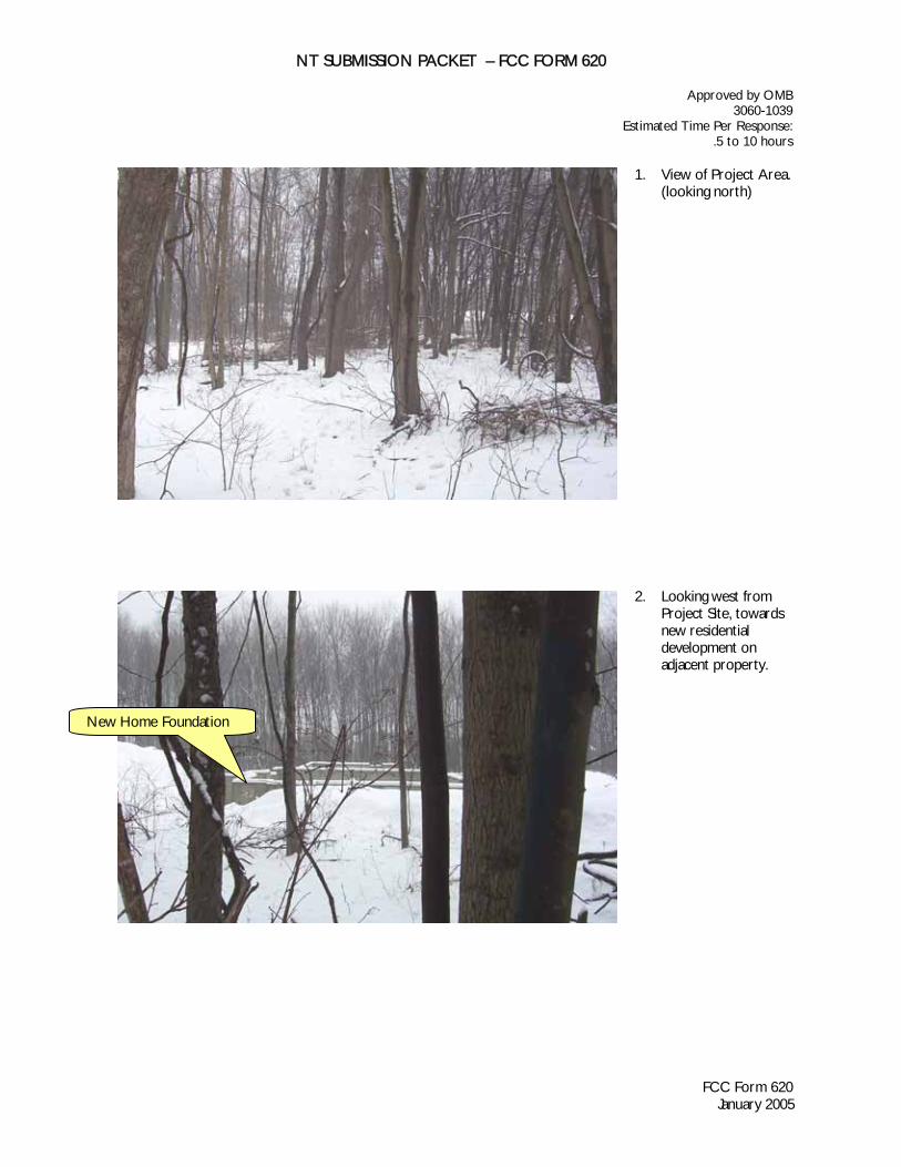
1. View of Project Area. (looking north)
2. Looking west from Project Site, towards new residential development on adjacent property.
New Home Foundation

NT SUBMISSION PACKET – FCC FORM 620
Approved by OMB 3060-1039
Estimated Time Per Response: .5 to 10 hours
FCC Form 620 January 2005
3. Facing south towards small stream, wetland area.
4. Facing east through brush towards Candlewood Baptist Church.

NT SUBMISSION PACKET – FCC FORM 620
Approved by OMB 3060-1039
Estimated Time Per Response: .5 to 10 hours
FCC Form 620 January 2005
5. Subject Property building viewed from Stadley Rough Road, (view looking west/southwest).
6. Access drive along western border of Property (facing south).
Project Site in rear, wooded corner
Church Building
Project Site
Transformer

NT SUBMISSION PACKET – FCC FORM 620
Approved by OMB 3060-1039
Estimated Time Per Response: .5 to 10 hours
FCC Form 620 January 2005
7. Residential homes located across Stadley Rough Road (east) of Property.
8. Facing west toward Project Site (through brush) from edge of existing church access drive.
NT SUBMISSION PACKET – FCC FORM 620
Approved by OMB 3060-1039
Estimated Time Per Response: .5 to 10 hours
FCC Form 620 January 2005
Attachment 12. Maps Include one or more 7.5-minute quad USGS topographical maps that: a. Identify the Areas of Potential Effects for both direct and visual effects. If a map is copied from the original,
include a key with name of quad and date. b. Show the location of the proposed tower site and any new access roads or other easements including
excavations. c. Show the locations of each property listed in Attachments 8 and 9. d. Include keys for any symbols, colors, or other identifiers.
Attached maps include a Street Map and Topographic Map showing the location of the proposed Project Site (Figures 1 and 2). Also attached are a Site Sketch (Figure 3), a Photo-location Map (Figure 4), a Historic Resources/Viewshed Map, and detailed Site Plans/Lease Exhibits provided by the project proponent. The APE for Direct Effects is identified on the attached Site Plans. The APE for Visual Effects is identified on the attached Photo-location Map. The location of the proposed collocation site and any related excavations are shown on the Site Plans/Lease Exhibits. Historic Properties identified in Attachments 8 and 9 are identified on the Historic Resources/Viewshed Map.

Subject Property
Danbury 1 52 Stadley Rough Road
Danbury, CT 06811
Figure 1: Location Map

Danbury 1 52 Stadley Rough Road
Danbury, CT 06811
A portion of the 1982 Danbury, CT USGS 7.5x15 Minute Quadrangle Scale 1:24,000
Subject Property
Figure 2: Locus Map

Septic system Existing parking lot
UST
Drinking Water Well
Figure 3: Site Plan
Danbury 1 52 Stadley Rough Road
Danbury, CT 06811
Church
Proposed Tower Compound
Stadley Rough Road

Danbury 1 52 Stadley Rough Road
Danbury, CT 06811
A portion of the 1982 Danbury, CT USGS 7.5x15 Minute Quadrangle Scale 1:24,000
Subject Property
1, 2
6
3, 4
5, 7 8
Figure 4: Photo Locations

SITE PLAN
500 EN
TERPR
ISE D
RIVE
RO
CK
Y H
ILL, CO
NN
EC
TICU
T1(860)5298882
CAN
DLEW
OO
D BA
PTIST C
HU
RC
H52 STAD
LEY R
OU
GH
RO
ADD
AN
BU
RY
, CO
NN
ECTIC
UT
L1

COMPOUND PLAN
L2500 ENTERPRISE DRIVE
ROCKY HILL, CONNECTICUT1(860)5298882
CANDLEWOOD BAPTIST CHURCH52 STADLEY ROUGH ROADDANBURY, CONNECTICUT

L3
TOWER ELEVATION
500 ENTERPRISE DRIVEROCKY HILL, CONNECTICUT
1(860)5298882
CANDLEWOOD BAPTIST CHURCH52 STADLEY ROUGH ROADDANBURY, CONNECTICUT
NT SUBMISSION PACKET – FCC FORM 620
Approved by OMB 3060-1039
Estimated Time Per Response: .5 to 10 hours
FCC Form 620 January 2005
Attribution and Bibliographic Standards. All reports included in the Submission Packet should be footnoted and contain a bibliography of the sources consulted. a. Footnotes may be in a form generally accepted in the preparer’s profession so long as they identify the
author, title, publisher, date of publication, and pages referenced for published materials. For archival materials/documents/letters, the citation should include author, date, title or description and the name of the archive or other agency holding the document.
b. A bibliography should be appended to each report listing the sources of information consulted in the
preparation of the report. The bibliography may be in a form generally accepted in the preparer’s profession.
References are appended. FCC NOTICE TO INDIVIDUALS REQUIRED BY THE PRIVACY ACT AND THE PAPERWORK REDUCTION ACT The FCC is authorized under the Communications Act of 1934, as amended, to collect the personal information we request in this form. We will use the information provided in the application to determine whether approving this application is in the public interest. If we believe there may be a violation or potential violation of a FCC statute, regulation, rule or order, your application may be referred to the Federal, state or local agency responsible for investigating, prosecuting, enforcing or implementing the statute, rule, regulation or order. In certain cases, the information in your application may be disclosed to the Department of Justice or a court or adjudicative body when (a) the FCC; (b) any employee of the FCC; or (c) the United States Government is a party to a proceeding before the body or has an interest in the proceeding. In addition, all information provided in this form will be available for public inspection. If you owe a past due debt to the federal government, any information you provide may also be disclosed to the Department of Treasury Financial Management Service, other federal agencies and/or your employer to offset your salary, IRS tax refund or other payments to collect that debt. The FCC may also provide this information to these agencies through the matching of computer records when authorized. If you do not provide the information requested on this form, the application may be returned without action having been taken upon it or its processing may be delayed while a request is made to provide the missing information. Your response is required to obtain the requested authorization. We have estimated that each response to this collection of information will take an average of .50 to 10 hours. Our estimate includes the time to read the instructions, look through existing records, gather and maintain the required data, and actually complete and review the form or response. If you have any comments on this estimate, or on how we can improve the collection and reduce the burden it causes you, please write the Federal Communications Commission, AMD-PERM, Paperwork Reduction Project (3060-1039), Washington, DC 20554. We will also accept your comments via the Internet if your send them to [email protected]. Please DO NOT SEND COMPLETED APPLICATIONS TO THIS ADDRESS. Remember - you are not required to respond to a collection of information sponsored by the Federal government, and the government may not conduct or sponsor this collection, unless it displays a currently valid OMB control number of if we fail to provide you with this notice. This collection has been assigned an OMB control number of 3060-1039. THE FOREGOING NOTICE IS REQUIRED BY THE PRIVACY ACT OF 1974, P.L. 93-579, DECEMBER 31, 1974, 5 U.S.C. 552a(e)(3), AND THE PAPERWORK REDUCTION ACT OF 1995, P.L. 104-13, OCTOBER 1, 1995, 44 U.S.C. 3507.

NT SUBMISSION PACKET – FCC FORM 620
Approved by OMB 3060-1039
Estimated Time Per Response: .5 to 10 hours
FCC Form 620 January 2005
References: USGS Topographic Map, Danbury, CT 1982 CT SHPO file review, January 15, 2006 – no properties identified National Register of Historic Places – online database http://www.nr.nps.gov/nrloc1.htm
January 25, 2006 – No properties identified Aerial Photographs (1934, 1951, 1972, 1990, 2004) Interview with Property Representatives (Pastor Fox) to obtain Subject Property information Assessors Property Card

EBI Consulting
APPENDIX E TRIBAL CORRESPONDENCE


EBI Consulting
APPENDIX F LAND RESOURCES MAP

7
Nabby
Hawley
Stadley RoughKaren
JacksonC
orn Tassle
Palm
erFa
irway
Tam
man
y
Royal
Sil Cam
Dixon
Woodbury
Royal Pine
Kend
all
Haus
man
n
Valleyview
Indian Spring
Jams
Mon
arch
Gol
fvie
w
Country
Kukila
Bradford
Sunnys
ide
Lamar
Purchase
Tabor
Moody
Dogwood
JuniperDeer Run
Cypress
Dennis Gate
Lawehana
HancockHeartwood
Land Based Resources PN: 61053482Source: Selected data from MAGIC, CT DEP, FEMA, NWI, ESRI, and EBI.
Legend
Project SiteSite buffer at 250', 500',1000', and 1/2 mileNatural Diversity Database AreaDesignated Open Space
Q3 Flood ZoneA (-E, -H, -O) - 100-year inundation area.D - Area of possible flood hazard.VE - 100-year inundation area, with wave action.X500 - 500-year inundation area.
Federal Land - AgencyBIABLMBORDODFSFWSNPSOther/Unknown
Stream or CreekFreshwater Forested/Shrub WetlandFreshwater Emergent WetlandEstuarine and Marine WetlandUnconsolidated ShoreFreshwater Lake, Pond, or RiverEstuarine and Marine DeepwaterOpen Water
Map note:This figure is utilized to determine the proximity of specific features to the project site. The legend represent all land-based features overlayed to determine their proximity to the subject property. The legend allows the reader to determine what's "present" or "not present" within the defined site radius.
0 800400 Feet
1 inch equals 800 feetDanbury 152 Stadley Rough Road
Danbury, CT 06811

EBI Consulting
APPENDIX G UNITED STATES FISH AND WILDLIFE
& CONNECTICUT DEPARTMENT OF ENVIRONMENTAL PROTECTION
CORRESPONDENCE


EBI Consulting
APPENDIX H WETLANDS MAPS


EBI Consulting
APPENDIX I FEMA FLOODPLAIN MAP

Flood Insights test results for :
Latitude: 41.4296 Longitude: -73.430666 Geocoding Accuracy: Not Available
Flood Zone Determinations Test Description SFHA (Flood Zone) Within 250 feet of multiple flood zones?Out No
Community Community Name Zone Panel Panel Date Cobra090004 DANBURY, CITY OF C 0005B April 16, 1982 OUT FIPS Code Census Tract09001 2114.00
Copyright 2000, First American Flood Data Services. All rights reserved.
This report was generated by: ebi on 12-27-2005 This Report is for the sole benefit of the Customer that ordered and paid for the Report and is based on the property information provided by that Customer. That Customer's use of this Report is subject to the terms agreed to by that Customer when accessing this product. No third party is authorized to use or rely on this Report for any purpose. NEITHER FIRST AMERICAN FLOOD DATA SERVICES NOR THE SELLER OF THIS REPORT MAKES ANY REPRESENTATIONS OR WARRANTIES TO ANY PARTY CONCERNING THE CONTENT, ACCURACY OR COMPLETENESS OF THIS REPORT, INCLUDING ANY WARRANTY OF MERCHANTABILITY OR FITNESS FOR A PARTICULAR PURPOSE. Neither TFHC nor the seller of this Report shall have any liability to any third party for any use or misuse of this Report.
Page 1 of 1
12/27/2005http://www.floodinsights.com/XsiteScripts/hsrun.hse/FloodInsights/FloodLookups/StateI...


![Why the North American Model of Wildlife Conservation is ... · conservation (e.g., Clean Water Act, Clean Air Act, National Environmental Policy Act [NEPA]). The environmental movement](https://img.pdfslide.us/doc/110x75/5e1acd41a6a53055dd60475a/why-the-north-american-model-of-wildlife-conservation-is-conservation-eg.jpg)