Embed Size (px)
Citation preview
3
Sri Lanka J. Aquat. Sci. 19 (2014): 3-14
Environmental flow in Sri Lanka: ancient anicuts versus
modern dams
E.I.L.SILVA1*, HERATH MANTHRITHILAKE2, DAMMIKA PITIGALA3
and E.N.S. SILVA1
1Water Resources Science and Technology, 77/2, Hettiyawatte, Elapitiwela,
Ragama, Sri Lanka 2International Water Management Institute, 127 Sunil Mawatha, Pelawatte,
Battaramulla, Sri Lanka 3Sri Lanka Mahaweli Authority, Ministry of Irrigation and Water Resources
Management, 500, T.B. Jaya Mawatha, Colombo 10, Sri Lanka
* Corresponding author: [email protected]
Abstract
Environmental flow describes the stream flow (quantity and regime) required to
sustain upstream and downstream habitats, riparian vegetation, human livelihoods
and wildlife. When natural rivers or tributaries are held back by weirs, anicuts,
barrages or dams, for a variety of purposes such as diversion for irrigation,
hydropower generation or flood control often the downstream flow requirement is
ignored or neglected. Although there is no universally accepted definition,
convention or law on environmental flow, it has been now recognized that
environmental flow is essential for sustainability of riparian ecosystem and their
services, which are essential for our own existence, livelihoods and many more.
This paper looks at physical structures constructed across rivers and tributaries in
Sri Lanka since ancient times to date (including mini-hydro power stations) with a
view to understand whether simple ancient wisdoms are more appropriate than
modern structures for nature conservation. There are tangible evidence to defend
that the ancient anicuts known as “amuna” surged sufficient water in tributaries and
rivers, to sustain the environment than modern engineering works which has created
dead river beds immediately downstream in many streams and rivers.
Keywords: Environmental flow; anicuts, river continuum; weirs; mini-hydropower
Introduction
River basins have been important sites of human settlements for thousands of years,
although it was not until the early twentieth century that development began to
transform basin ecosystems into modified man-made ecosystems in order to achieve
socio-economic benefits. With the technological and engineering supremacy and

4
E.I.L. Silva et al./ Sri Lanka J. Aquat. Sci. 19 (2014): 3-14
ability to control nature for its own benefit, river basin development was carried out
by the humans with little or no recognition of the ecological, social, economic, and
cultural benefits of free-flowing rivers. As a consequence, river basins suffer from
significant ecological degradation in the global context. Large-scale, multipurpose
mega basin developments were initiated in the US in particular, where, during early
nineties, and prior to World War II, basins such as those of Tennessee, Columbia,
and Colorado underwent massive transformations. This development model was
adopted by the developing countries in the South including Sri Lanka. River basin
development facilitated irrigated agriculture, downstream settlement and
industrialization. In other words, basin development promoted modernization and
regional development. In the latter half of the twentieth century and the early years
of the twenty-first century, concern for the ecological and social impacts of river
basin development has built up incessantly. As a result, basin development projects
and management plans – and the narrow vision of modernization upon which they
are often based – tend to be more politicized and contested than was the case in the
early and mid twentieth century. Today, in response to critiques, sustainable
development and integrated water resources management are key concepts guiding
river basin–community relations. While advances in sustainable management have
been significant in the North, many challenges remain in the South. This is
especially the case in fast tracked developing countries such as Sri Lanka, where the
political will is so strong than ecological legacy when sharing and managing natural
resources.
Environmental flow describes the quantity of water flow required to sustain
upstream and downstream habitats, riparian vegetation, human livelihoods and
wildlife when a river or tributary is held back by a weir, anicut, barrage or dam, for
a variety of the purposes such as diversion for irrigation, hydropower generation or
flood control. Although there is no universally accepted definition, convention or
soft law of environmental flow, it has been now recognized that environmental flow
is essential for healthy running water and associated riparian ecosystems. The
impacts of physical structures constructed for stream/river flow regulation are
perceived to be of critical importance on riverine and riparian aquatic flora and
fauna due to microhabitat alteration, discontinued linkages of food chains, changes
in benthic drift, nutrient spiraling and catadromous and potamodromous fish
migration (Angermeierand Karr1984; Townsend1996; Ledec and Quintero 2003).
Silva and Davies (1986) reported upstream spawning migration of riverine fish in
Sri Lankan streams, whereas Silva (1993) highlighted the potential negative impacts
of trunk stream dams across the Mahaweli River on riverine fish populations.
Weirs, dams and anicuts often re-route water through canals, channels,
tunnels or pipelines to increase the pressure and remove silt, leaving long stretches
of dry bed rocks. Exposed bed rocks and boulders are heated up by incident solar
radiation increasing adjacent water temperature during day time and cooling during
night due to blackbody radiation. Weirs barrages, dams and tunnels also have a
negative impact on fish populations as many fish species migrate for spawning
(Arthington et al. 2006). Fish ladders give fish an alternative means to move up or

5 E.I.L. Silva et al./ Sri Lanka J. Aquat. Sci. 19 (2014): 3-14
downstream. They can be used to improve fish movements; however, in most cases,
this has not been facilitated in Sri Lanka. In contrast, there are tangible evidences to
assume that an ancient irritation weir known as “amuna” had facilitated upstream
and downstream fish movements. According to Fernando (2002) the fall of the
ancient hydraulic civilization of Sri Lanka in the 13th century was due to sudden
natural cataclysmic change of the river course of the Mahaweli and was not due to
foreign invasions as historians would want us to believe. But there is no evidence to
show a sudden geological catyclysm that changed the river course that sustained our
ancient hydraulic civilization, leading to disease and famine. Nonetheless, it is
sensible to compare ancient systems with modern constructions. The vision behind
the ancient hydraulic civilization of Sri Lanka was based on scientific principles of
integrated water resource management with recognition of company property rights.
According to the ancient chronicles, Arahat Mahinda, the monk son of Emperor
Asoka of India, is recorded in the Mahawamsa as advising to then king of Sri Lanka
that the land belongs to the people and all living beings, while the ruler is only the
guardian of the land (Weeramantry 2000).Therefore the aim of the present analysis
is to highlight certain vital features of both systems to understand whether the
ancient wisdoms of stream flow regulation is more suitable than modern
technologies with respect to nature conservation.
Materials and Methods
Flow regulatory structures namely ancient weirs (amuna), British anicuts, ancient
and modern irrigation and hydro dams, barrages and mini-hydro weirs already
existing on five river basins (viz., Mahaweli, Walawe, Kala, Yan and Maduru Oya
basins) designated under Mahaweli development programme were examined for a
period of six months from July to December 2013. The locations were identified
using published literature (Arumugam 1969), one inch and metric (1:50,000)
topographic sheets and also information obtained from respective government
officials and peasants. Observations were made mainly on the nature of the
immediate downstream of the physical structure (e.g. nature of the bottom, micro-
habitats and aquatic organisms including fish), riparian conditions of river banks to
some extent downstream, and the magnitude of the physical structure. Geographical
positions were taken using a GPS which were later corrected with Google-Earth
land satellites. Google-Earth Ruler and New Path were used to measure straight-line
distances and meanders respectively.
Results and Discussion
Basic feature of the five river basins are summarized in Table 1. These river basins
have been subjected to intensive stream flow regulations since ancient time to date,
the hydrological networks are more artificial courses than natural flow regimes.
Besides, the existing on-stream artificial structures constructed for flow-regulation,
there are different types of regulatory structures of different magnitude as shown in
Table 2. Further, water retention in the basin by constructing reservoirs, tanks and

6
E.I.L. Silva et al./ Sri Lanka J. Aquat. Sci. 19 (2014): 3-14
canals have resulted in less water and material discharge into the Indian Ocean
(Table 1). Except, Mahaweli and Walawe other three watersheds are mainly
confined to the dry zone with small potions being located in the intermediate zone.
The Walawe river basin discharges the maximum amount of water into the Indian
Ocean as a percentage annual precipitation. Kala Oya basin receives the minimum
annual precipitation volume per unit watershed area whereas the highest value is
computed for Mahaweli basin (Table 1). This can be attributed to the geographical
distribution of the basin to experience both southwest and northeast monsoonal
rains. Basic hydrological data of five river basins indicate that there is an acute
water shortage in Kal Oya basin compared to the other four river basins.
Ancient weirs (amuna)
Hydraulic civilization of ancient Sri Lanka has direct bearings with early human
settlements in the dry zone. Two types of ancient systems were prominent. Partial
diversion of major rivers to achieve inter-basin transfer or to feed lateral storage
tanks for irrigation was common during the ancient time. An example is partial
diversion of the Mahaweli River at Minipe constructing “Manimekkala dam” across
the river to convey water though about 22 km long Minipe Yoda Ela (Aggabodhi I,
575-608 A.C.) which was extended to 78 km during the reign of King Sena II
(853-887, A.C.). The height of 224 m long anicut was raised to 4.2 m in 1947. This
indicates that there had been a sufficient flow over the ancient anicut constructed by
ancient kings. An ancient diversion scheme with 46 km long feeder channel
constructed across the Kalu Ganga, a tributary of Amban Ganga near Pallegama
(7°34'16.46"N; 80°50'8.76"E @ 163 m amsl) during the reign of Aggabodhi II
(608-618 A.C.) which had been repaired and rehabilitated by Parakrama Bahu I
(1153-1186 A.C.) had been in existence according to the ancient chronicles.
According to Arumugam (1969), Hattota amuna may not be the identical one which
was restored in 1952-1957. It looks more abandoned at present and there is no
continuous river flow over the 97 m long weir.
Elehera anicut (amuna), a work of ancient antiquity (Arumugama 1969),
has many references to ancient kings namely Vasaba (65- 109 A.C.), Aggabodhi II
(608-618 A.C) and Parakrama Bahu I (1153-1186 A.C.). There are two weirs, the
115 m long large one across the Amban Ganga and small one across Kuda Ganga
(29 m long) to divert water in the Amban Ganga for direct development of irrigation
and augment supply to Minneriya and Giritale tanks through Elaehera-Minneriya
Yoda Ela, which bifurcates after 34 km at Diyabeduma. This system was reported to
be restored in 1887 and again in 1945 with several modifications including the weir
height. At present flood flow spills over the main weir across Amban Ganga. The
weir and the conveyance canal, which was known as Akasa Ganga, now call
Angamedila–Yoda Ela was a partial diversion of Amban Ganga water to feed
Parakrama Samudra (Parakrama Bahu I, 1153-1186 A.C.). This was restored in
1948-1952 raising the 27.4 m long weir arresting continuous flow over it. However,
there is a scour gate of 1.5x1.2 m2 which also regulates the water level behind the
7 E.I.L. Silva et al./ Sri Lanka J. Aquat. Sci. 19 (2014): 3-14
weir but fish cannot swim against the flow. Uggal Kaltota diversion weir on the
Walawe River which also belongs to ancient category was built under the regime of
King Gaja Bahu (112-134 A.C.). In 1892, the right bank channel was restored and
an independent weir of 71 m long and 1 m high was constructed upstream
(6°39'50.63"N; 80°52'46.64"E @ 155 m amsl) in 1956 to provide water for new left
bank irrigation. Because of the relatively small height of the weir there is a
continuous spill over.
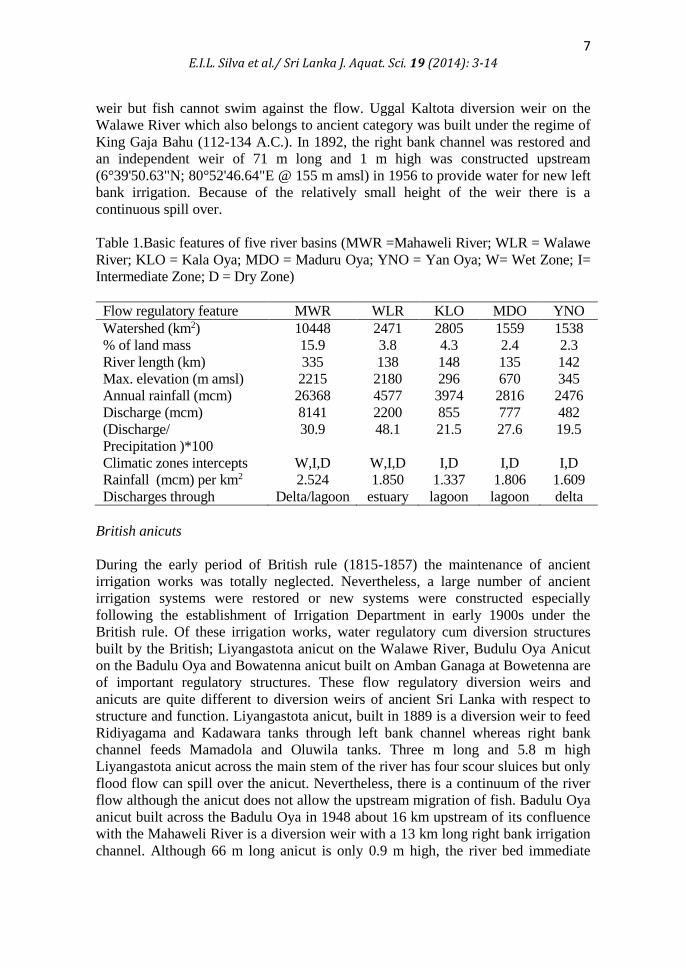
Table 1.Basic features of five river basins (MWR =Mahaweli River; WLR = Walawe
River; KLO = Kala Oya; MDO = Maduru Oya; YNO = Yan Oya; W= Wet Zone; I=
Intermediate Zone; D = Dry Zone)
Flow regulatory feature MWR WLR KLO MDO YNO
Watershed (km2) 10448 2471 2805 1559 1538
% of land mass 15.9 3.8 4.3 2.4 2.3
River length (km) 335 138 148 135 142
Max. elevation (m amsl) 2215 2180 296 670 345
Annual rainfall (mcm) 26368 4577 3974 2816 2476
Discharge (mcm) 8141 2200 855 777 482
(Discharge/
Precipitation )*100
30.9 48.1 21.5 27.6 19.5
Climatic zones intercepts W,I,D W,I,D I,D I,D I,D
Rainfall (mcm) per km2 2.524 1.850 1.337 1.806 1.609
Discharges through Delta/lagoon estuary lagoon lagoon delta
British anicuts
During the early period of British rule (1815-1857) the maintenance of ancient
irrigation works was totally neglected. Nevertheless, a large number of ancient
irrigation systems were restored or new systems were constructed especially
following the establishment of Irrigation Department in early 1900s under the
British rule. Of these irrigation works, water regulatory cum diversion structures
built by the British; Liyangastota anicut on the Walawe River, Budulu Oya Anicut
on the Badulu Oya and Bowatenna anicut built on Amban Ganaga at Bowetenna are
of important regulatory structures. These flow regulatory diversion weirs and
anicuts are quite different to diversion weirs of ancient Sri Lanka with respect to
structure and function. Liyangastota anicut, built in 1889 is a diversion weir to feed
Ridiyagama and Kadawara tanks through left bank channel whereas right bank
channel feeds Mamadola and Oluwila tanks. Three m long and 5.8 m high
Liyangastota anicut across the main stem of the river has four scour sluices but only
flood flow can spill over the anicut. Nevertheless, there is a continuum of the river
flow although the anicut does not allow the upstream migration of fish. Badulu Oya
anicut built across the Badulu Oya in 1948 about 16 km upstream of its confluence
with the Mahaweli River is a diversion weir with a 13 km long right bank irrigation
channel. Although 66 m long anicut is only 0.9 m high, the river bed immediate

8
E.I.L. Silva et al./ Sri Lanka J. Aquat. Sci. 19 (2014): 3-14
downstream is almost dead under base flow. Bowetenna anicut was a regulatory
weir built across Amban Ganga in 1895 at 7°39'41.61"N; 80°40'31.96"E @ 236 m
amsl to provide irrigation water for 230 ac of rice fields blocked only 6.6 m of about
66 m wide river channel by a 1.5 m high dam. This small anicut is abandoned now
after the construction of Bowetenna reservoir under the Mahaweli Programme
leaving about 2 km between Bowatenna dam and its power plant outflow. British
also built several small anicuts across other highland tributaries of the Mahaweli
River namely Murapola Ela and Ma-Ela anicuts across the two tributaries of Maha
Oya near Marassana and Rikillagaskada, Lamasuriyagama anicut across Belihul
Oya, and Maha-Eliya, Mahatotilla and Bathmedila anicuts in the Uma Oya basin.
Although the details of these anicuts are beyond the scope of this report, none of the
British anicuts facilitated environmental flows.
Irrigation cum hydro dams
Two types of trunk stream irrigation dams, namely ancient and modern, are in
existence. Although most ancient types are found in Malwathu Oya basin (e.g.,
Nachchaduwa, Nuwara Wewa, Basawakkulama, Tisa Wewa) there are few in Kala
Oya (e.g. Kalawewa-Balaluwewa twin reservoirs) and Yan Oya basins e.g., Hurulu
Wewa. There is evidence for the existence of a trunk stream reservoir on the
Maduru Oya, immediate downstream of the present irrigation cum hydro dam.
However, no trunk stream irrigation tanks of ancient category are found on the
Mahaweli and Walawe river basins. Major ancient irrigation tanks found on the
Mahaweli basin (e.g., Minneiriya, Giritale, Parakrama Samudra, Kaudulla,
Sorabora), and Kala Oya basin (Usagala Siyabalnagamuwa and Angamuwa) are
lateral reservoirs fed by either their own local watershed and augmented by diverted
water. Kala Wewa was built during the reign of King Dhathusena (459-447 A.C.)
impounding Dambulu Oya by 3.46 km long earthen embankment of 18 m height.
This was restored in 1887 and the dam was raised by another 2 m in 1939. In 1958,
two reservoirs Kala Wewa and Balalu Wewa merged together forming one large
reservoir. There are three sluices to release water; one to Jaya Ganga and two for
irrigation command, and 182 m long concrete masonry spill and high level natural
spill at the Left Bank end (Arumugam 1969). Nevertheless, river carries flood water
and irrigation return flows from Kala Wewa to Rajangana for 40 kilometers.
Hurulu wewa on the Yan Oya basin is also a main stem irrigation tank that
belongs to ancient category, built during the reign of King Mahasena (276-303
A.C.). The reservoir was restored in 1949 but the tank bund was breached during
1957 December flood. The present dam, 2.6 km long with 24 m height with double
curve concrete and natural spills of 22 m and 152m respectively does not provide
upstream-downstream connectivity except during floods.
Rajanganya wewa, built in 1957 is a terminal reservoir in the Kala Oya
basin, meant only for irrigation has a 1.66 km long and 6 m high reservoir bund
with 68 m wide concrete spill and two sluices (left bank and right bank) to convey
water for irrigation command. Downstream river channel is dead to some distance

9 E.I.L. Silva et al./ Sri Lanka J. Aquat. Sci. 19 (2014): 3-14
and collect water from local precipitation and irrigation returns flows in addition to
ground water recharge.
Udawalawe reservoir, the third largest inland water body built on the
Walawe River is the only trunk stream dam in the river basins of the designated
Mahaweli areas which generates hydropower in addition to irrigation supply. The
river has been held back by a 4.5 km long and 40 m high earthen embankment to
impound 268 mcm of water in the reservoir. The reservoir conveys irrigation water
through left bank and right bank sluices which also generate hydropower and flood
water spill through five radial gates and 380 m wide natural spill. In this case also
there is no continuous river flow and downstream the dam river water is mainly
local precipitation, groundwater recharge and irrigation return flows.
Hydro-power dams
Kotmale Oya, one of upper most tributaries of the Mahaweli River has been
dammed at Talawakele forming Upper Kotlame Hydropower reservoir (UKHP), a
so-called run-off river system. It is a gravity dam, 180 m crest length and 35.5 m
high with five spillways of 3000 m3/s capacity. However, immediate downstream of
the UKHP dam, the river is almost dead, for 4.36 km till water from the Devon fall
merges with Kotmale Oya at 6°57'31.42"N; 80°38'4.85"E @ 974 m amsl. Kotmale
Oya has been blocked again creating Kotmale Oya reservoir, at Kadadora village,
28.8 km downstream of UKHP dam about 6.6 km upstream where it confluences
with Hatton Oya, near Pallegama to form the Mahaweli River proper. A rock-filled
dam across Kotamale Oya at Kadadora is 87 m high and 600 m long has a chute
spillway with a capacity of 5500 m3/s consisting of 3 radial gates of 14x15m.
However, there is no water in this stretch of the stream under dry weather for 6 km
up to Pallegama where Hatton Oya merges with it on left bank.
Victoria, the third main stem high dam of the Mahaweli River is a double
curvature arch concrete dam at Vitoria falls, 64 km downstream of Kotmale dam
creating two wings (Hulu and Mahaweli) Victoria reservoir. The dam is 122m in
height with a crest length of 520m impounding 770 mcm of water with eight
spillways of 8.200 m/s capacity. Aquatic habitats and riparian vegetation of the
Mahaweli River is almost dead from immediate downstream of Victoria dam to
5.78 km until it receives power station out-flow from its right bank although three
left bank tributaries of minor importance merge with the main stream. The
mainstream of the Mahaweli River is again blocked by a rock-filled dam (94 m high
and 485 m long with three spillways of 8,300 m3/s capacity), 19 km downstream of
Victoria reservoir, creating Randenigala reservoir, which is also fed by Belihul Oya
and Kurundu Oya on the right bank. The Mahaweli water which is released from
Randenigala power station is then conveyed directly into Rantembe reservoir (21.0
mcm) through 2.98 km long concrete channel which is also fed by the Uma Oya, a
tributary with the largest right bank catchment that spread over Uva basin. The
water is held back by 420 m long and 43.5 m dam facilitated with spillway of
10,235 m3/s. The tailrace of the power house is located immediate downstream and
water is diverted to Minipe Yoda Ela and right bank channel after 3 km leaving no

10
E.I.L. Silva et al./ Sri Lanka J. Aquat. Sci. 19 (2014): 3-14
sufficient river flow from the Minipe anicut to Weragantota for 17.5 km. A recent
study has shown the low abundance and diversity of fish species in this stretch of
the river in relation to Legal Oya (Rajakaruna et al. 2013). Apparently the massive
structures of the five hydro dams on the trunk stream of the Mahaweli River have
no facilities for environmental flows what so ever. The situation is bit different at
Samanala Wewa reservoir on Walawe River basin because of existing leakage
which appears as a small spring in the right bank about 300 m downstream of the
dam. The dam was rock filled 100 m high and 530 m long impounding a total
storage of 218 mcm water with a spill-way with three gates which has the capacity
of 3,600 m3/s. The stretch of the river between the dam and the Diyawini Oya goes
dry depriving the farmers any water for their cultivation, except for some little
water coming from a few small tributaries in between.
Table 2. Major flow regulatory features of five river basins (MWR =Mahaweli River;
WLR =Walawe River; KLO = Kala Oya; MDO = Maduru Oya; YNO = Yan Oya;
MHP = mini-hydro-power plant; number right to slash denotes visited; na - not
applicable; e-flows - environmental flows; Irr- Irrigation)
Flow regulatory features MWR WLR KLO MDO YNO
Puranaamuna 04/04 01/01 00 00 00
British anicuts 02/02 01/01 00 00 00
Trunk stream Irrigation dams 00 00 04/04 00 01/01
Hydropower dams 05/05 01/01 00 00 00
Trunk stream Irr./hydro dams 00 01/01 00 01/01 00
Tributary/Diversion /Hydro
dams
01/01 00 00 00 00
Barrages or Diversion 01/01 00 01/01 00 00
Number of MHP 60/55 07/07 00 03/03 00
MHP with sufficient e-flows 01 00 00 00 00
MHP with fish ladders 03 00 00 00 00
Trunk stream Hydro dams 05/05 01/01 00 00 00
No of trunk stream anicuts 01/01 01/01 01/01 00 02
No of major lateral reservoirs 12 03 05 01 03
No of link tunnels 05 00 00 01 00
No of trunk stream causeways 00 00 01/01 00 00
Polgolla Barrage and Neela Bemma
Under Mahaweli River Development programme the river was blocked by a barrage
at Polgolla (7°19'17.11"N; 80°38'41.39"E @ 450 m amsl) partially diverting water
through 5.6 km trans-basin tunnel which releases water to Sudu Ganga at Ukuwela
after generating 2x20 MW. Subsequently, Mahaweli water is conveyed to Dambulu
Oya, Kandalama Wewa and Hurulu Wewa via Bowetenna reservoir through 8.22
km link tunnel. The place where the tunnel opens called Lendora village is unique
since Mahaweli water is transferred to Kala Oya and Yan Oya. Polgolla barrage,

11 E.I.L. Silva et al./ Sri Lanka J. Aquat. Sci. 19 (2014): 3-14
which is 14.6 m high and 144 m long has 10 sluice gates to release water as the
need arises. However, when all sluices are closed, the river has no flow for 13 km
until it meet the Victoria reservoir indicating an irregular river flow through this
stretch of the Mahaweli River as a result of no inbuilt facility for environmental
flow.
Neela Bemma, which is a 147 m long and 14 m high concrete dam with two
spills, with regulator gates and two sluice tunnels was constructed across Kala Oya
at 8°12'57.29"N; 80° 4'57.89"E @ 31 m amsl about 18 km downstream of
Rajanganaya dam in 1995. Apparently there is continuous flow over this dam
except under extreme dry conditions. However the attempts of fish jumps over the
dam are not successful because of the height of the dam.
Mini-hydropower plants
Up to recent past, the state-of-the-art of the power industry in Sri Lankan is
construction on mini-hydropower plants (MHPP) on running water including
streams, rivers, and irrigation channels. At present, Ceylon Electricity Board has
stopped signing power purchase agreements with MHPP developers (personal
communication, Prof. M.J.S. Wijeyaratne). During the present survey 65 of the 70
sites of the MHPP in the Mahaweli River basins, of various stages (i.e., approved,
under construction, grid connected) of which a majority were connected to the
national grid were visited and examined. Of the 70 sites, 60 are located in the
Mahaweli River basin including two cascade mini-hydropower plants in Sudu
Ganga and Hatton Oya, which were reported to be extremely high in aquatic
biodiversity especially riverine fish including endemic and migratory (De Silva and
Wansapura 1991; Silva et al. 2013). A large majority of small hydro plants are
assigned as “run-of-the-river” systems, meaning that they have no or relatively
small water storage capability. The turbine produces power only when the water is
available in the river. In the case of low head projects, either the water is diverted to
a power intake with a short penstock, as in the high head schemes, or the head is
created by a small dam, provided with sector gates and an integrated intake
powerhouse and fish ladder. Nevertheless, fish ladders and environmental flow
must be inbuilt into these mini-hydropower plants as an ecological requirement.
Ecological flow is also equally important as fish ladders when dams are built across
rivers. The existing irrigation canals can be modified to establish min-hydropower
plants by enlarging them to accommodate the intake, the power station, the tailrace
and the lateral bypass.
Over 90 % of the mini-hydropower plants were established within a narrow
time-frame. Each and every hill stream of Mahaweli and Walawe basin have been
tapped for mini-hydropower depending on the water availability with substantial
micro-catchments. Fish were found in almost all weir sites and at tailraces except in
few instances. The community structure and the abundance of fish population
varied with stream width and the elevation. Apparently, most of the stream habitats
were almost dead between the weir and the power station when water is transferred
by a headrace channel to a fore-bay and subsequently to penstock. A small amount

12
E.I.L. Silva et al./ Sri Lanka J. Aquat. Sci. 19 (2014): 3-14
of water is released from the weir as environmental flow, although they highlight
these power plants under the category of run-of-river system (e.g. Hulu Ganga
Phase I and II, Giddawa and Loggal Oya Mini-hydropower plants).
At certain power plants namely Mulgama mini-hydropower plant, located
downstream of Samanala Wewa natural leakage, no water was noticed in the stream
channel between the weir and the power station. Ceylon Electricity Board is
planning to construct another mini-hydropower plant upstream of the Mulgama
weir. Of the 67 mini-hydropower plants constructed across the mainstream or
tributaries only one, i.e., Koladeniya mini-hydropower plant constructed across the
Mahaweli River upstream Nawalapitiya was incorporated with a fish ladder and two
openings for environmental flow. Fish were crossing over the weir during overflow
according to the developer. Koladeniya mini-hydropower plant which is owned by the
Bank of Ceylon maintains the environmental requirements to acceptable norms. This
is a good message for the other developers as well as project approving agencies to
adhere to environmental requirement. Table 2 shows different types of flow-
regulatory features of five river basins which affect the stream ecological features and
fish community structure in respective river basins in the Mahaweli areas. None of the
regulatory structures, either ancient or modern, irrigation or power generation except
for Koladeniya mini-hydropower plant (dams, barrages, anicuts, diversion weirs etc.)
is facilitated with fish by-passes or hardly concerned on environmental flow
requirements.
Conclusions
There were no trunk stream reservoirs on the mainstream of Mahaweli River as the
ancient kings used the profuse base flow of the river to divert water using diversion
canals to major reservoirs located elsewhere. Construction of Kala Wewa on the
trunk stream of the Kala Oya could be an only option of transferring water to
Malwathu Oya via Jaya Ganga. Haththota Amuna, Minipe Elahera and Angamidela
systems are classic examples for partial diversion of running water maintaining
flow-continuum. British anicuts are quite different from ancient irrigation anicuts of
the kingdom of built tanks, because they did not consider the river continuum. The
reservoirs constructed since independence either under River Valley Development
Board or Mahaweli Development Programme were not planned according to
holistic ecosystem approach in the case of river basin development. In the present
context, environmental flow, riverine fish migration, endemic bio-diversity are the
bouncing ecological aspects related to stream flow regulation that cannot be ignored
although some considered that power generation by stream-flow regulation is a non-
competitive entrepreneurship.

13 E.I.L. Silva et al./ Sri Lanka J. Aquat. Sci. 19 (2014): 3-14
Acknowledgements
International Water Management Institute (IWMI) and the Mahaweli Authority of
Sri Lanka (MASL) provided funding and logistic support to Water Resources
Science and Technology to carry out a study on fish fauna of Mahaweli areas. Most
of the information and data presented in this paper were collected during the course
of the said study.
References
Angermeier P.L. and J.R. Karr 1984.
Relationships between woody debris and fish habitat in a small warm water
stream. Transactions of the American Fisheries Society113: 716–726.
Arthington A.H., S.E. Bunn, N.L. Poff and R.J. Naiman 2006.
The challenge of providing environmental flow rules to sustain river
ecosystems. Ecological Applications16:1311-1318.
Arumugam S. 1969.
Water Resources of Ceylon. Water Resources Board, Colombo.
De Silva K.H.G.M. and D.M. Wansapura 1991.
Distribution of fish species in the Mahaweli river system in Kandy District.
In: E.I.L. Silva (ed.), In-stream ecology and reservoir production of the
Mahaweli basin- a modified ecosystem. 9 p.
Fernando A.D.N. 2002.
The ancient hydraulic civilization of Sri Lanka
(http://wanni.org/hydraulic.htm last visited June 2014)
Ledec G. and J.D. Quintero 2003.
Good Dams and Bad Dams: Environmental Criteria for Site Selection of
Hydroelectric Projects, Latin America and Caribbean Region. Sustainable
Development Working Paper 16, World Bank, Washington.
Rajakaruna S.L., K.B. Ranawana A.M.T.A. Gunaratne and H.M.S.P. Madawala
2013.
Is there an impact of river flow regulation on endemic fishes of Mahaweli
downstream areas? Proceedings of the National Aquatic Resources
Research and Development Agency Research Symposium 2013 page 33.
Silva E.I.L. 1993.
Discontinuum of the Mahaweli River and its Impact on Distribution and
Diversity of Indigenous Riverine Fish Fauna. In: The proceedings of the
International an Interdisciplinary Symposium on Ecology and Landscape
Management in Sri Lanka. W. Erdelen, C. Preu, N. Ishwaran and C.M.
Madduma Bandara (eds) 397-414 pp. Margraf Scientific Books, D-97985
Weikershiem.
Silva E.I.L and R.W. Davies 1986.
Movements of some indigenous riverine fishes in Sri Lanka. Hydrobiologia
137: 265 – 270.

14
E.I.L. Silva et al./ Sri Lanka J. Aquat. Sci. 19 (2014): 3-14
Silva E.I.L., H. Manthrithilake, M.D. Piyathilake and R. Shirantha 2013.
Cascade of mini-hydropower plants on Sudu Ganga and its potential
impacts on riverine fish fauna. Proceedings of Water Professional Day, held
on 1st October 2013 at the Post-Graduate Institute of Agriculture. University
of Peradeniya, 115-125 pp.
Townsend C.R. 1996.
Concepts in river ecology: pattern and process in the catchment hierarchy.
Archiv für Hydrobiologie113:3–21.
Weeramanthy C.G. 2000.
Historical Background to Water Resource Management 2000.
http://www.waterboard.lk/sacosan/historicalsanitation.html Last visited M
June 2014