Embed Size (px)
Citation preview
Environmental Assessment – Eurasian Watermilfoil / Curlyleaf Pondweed Research Project
Sanders County, Montana Prepared for: Sanders County Extension 2504 Tradewinds Way, Suite 1B Thompson Falls, MT 59873 Montana Department of Agriculture Noxious Weed Program 303 North Roberts Helena, MT 59620 Prepared by: Tetra Tech 303 Irene St. Helena, MT 59601 114-560131 May 28, 2009

EA – Eurasian Watermilfoil / Curlyleaf Pondweed Research Project
Tetra Tech May 27, 2009 i
TABLE OF CONTENTS 1.0 PURPOSE AND NEED...........................................................................................................1 Introduction ............................................................................................................................. 1 Purpose and Need for Research Project ................................................................................ 3 Public Involvement and Scoping ............................................................................................. 3 2.0 ALTERNATIVES ................................................................................................................... 5 Alternative 1: No Action Alternative........................................................................................ 5 Alternative 2: Proposed Action for Dye testing and Herbicide Application............................. 5 3.0 AFFECTED ENVIROMENT AND ENVIRONMENTAL CONSEQUENCES .......................... 8 Existing Aquatic Weed Infestations......................................................................................... 8 Environmental Consequences ................................................................................................ 9 Alternative 1: No Action....................................................................................................9 Alternative 2 – Proposed Action...................................................................................... 10 Vegetation ....................................................................................................................... 10 Threatened, Endangered, And Sensitive Species .......................................................... 12 Wetlands ......................................................................................................................... 12 Environmental Consequences .............................................................................................. 13 Alternative 1: No Action.................................................................................................. 13 Alternative 2: Proposed Action....................................................................................... 13 Water Quality .................................................................................................................. 14 Environmental Consequences .............................................................................................. 18 Alternative 1: No Action.................................................................................................. 18 Alternative 2: Proposed Action....................................................................................... 19 Fisheries.......................................................................................................................... 20 Environmental Consequences .............................................................................................. 21 Alternative 1: No Action.................................................................................................. 21 Alternative 2: Proposed Action....................................................................................... 21 Wildlife ............................................................................................................................ 23 Environmental Consequences .............................................................................................. 25 Alternative 1: No Action.................................................................................................. 25 Alternative 2: Proposed Action....................................................................................... 25 Recreation....................................................................................................................... 26 Environmental Consequences .............................................................................................. 27 Alternative 1: No Action.................................................................................................. 27 Alternative 2: Proposed Action....................................................................................... 27 Soil Resources ................................................................................................................ 28 Environmental Consequences .............................................................................................. 28 Alternative 1: No Action.................................................................................................. 28 Alternative 2: Proposed Action....................................................................................... 29 Air Quality........................................................................................................................ 29 Environmental Consequences .............................................................................................. 30 Alternative 1: No Action.................................................................................................. 30 Alternative 2: Proposed Action....................................................................................... 31 Human Health .................................................................................................................31 Environmental Consequences .............................................................................................. 31 Alternative 1: No Action.................................................................................................. 31 Alternative 2: Proposed Action....................................................................................... 32 4.0 REFERENCES .................................................................................................................... 34
EA – Eurasian Watermilfoil / Curlyleaf Pondweed Research Project
Tetra Tech May 27, 2009 ii
LIST OF TABLES
TABLE 3-1 Acreage Infested By Invasive Aquatic Plants Within Lower Clark Fork reservoirs ...9 TABLE 3-2 Vegetation present in Noxon Rapids Reservoir .....................................................11 TABLE 3-3 Cover type and land use classification within the project area ...............................12 TABLE 3-4 Summary of Water Quality Standards for Herbicides Use in Pilot Study................18 TABLE 3-5 Threatened, Endangered, and Sensitive Species near Noxon Rapids Reservoir ..24 TABLE 3-6 National Ambient Air Quality Standards..................................................................30 TABLE 3-7 Particulate Monitoring Data from 2008 ...................................................................30
LIST OF FIGURES
FIGURE 1 Location Map..............................................................................................................2 FIGURE 2 Site Map .....................................................................................................................6 FIGURE 3 GWIC Wells within ¼ Mile of Study Plots .................................................................16
EA – Eurasian Watermilfoil / Curlyleaf Pondweed Research Project
Tetra Tech May 27, 2009 1
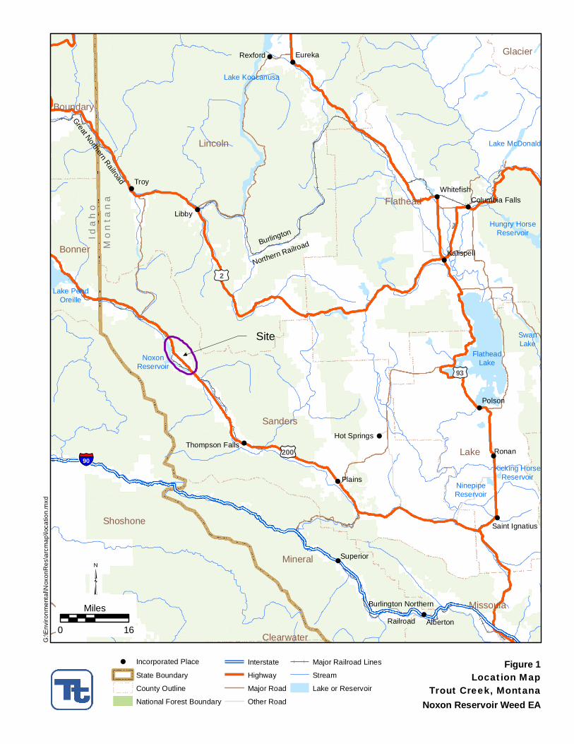
1.0 PURPOSE AND NEED INTRODUCTION Currently, the only known infestation of eurasian watermilfoil (Myriophyllum spicatum) in Montana is in Noxon Rapids and Cabinet Gorge Reservoirs where the plant was first discovered in 2007. Spread of this plant has the potential to impact aquatic environments and impair recreational resources. Inventory data collected in 2008 indicate eurasian watermilfoil infests 247 acres and 117 acres in Noxon Rapids and Cabinet Gorge Reservoirs, respectively. Montana’s Aquatic Nuisance Species Plan lists eurasian watermilfoil as a “priority class 3” species with a high potential for invasion and is listed as a Category 3 noxious weed in the state. In addition, two other invasive aquatic species, curlyleaf pondweed (Potamogenton crispus L.) and flowering rush (Butomus umbellatus L.) are also present in Noxon Rapids, Cabinet Gorge, and Thompson Falls Reservoirs. Eurasian watermilfoil and other invasive non-native aquatic plants have the potential to impact aquatic environments and impair recreational resources in Montana. Eurasian watermilfoil is adapted to a wide range of environmental conditions and has proven to be highly competitive in northern environments similar to Montana. The plant is tolerant of low temperatures and initiates growth in early spring, out competing and shading native aquatic vegetation. The plant grows quickly until reaching the water surface, forming dense canopies that shade surrounding vegetation (Madsen el al. 1991). Competition for sunlight and other resources results in a reduction in native plant diversity and abundance (Madsen 1994; Smith and Barko 1990). Dense infestations of eurasian watermilfoil also tend to support a lower abundance and diversity of invertebrates than do native aquatic plants, thereby reducing food availability for juvenile and forage fish. At high densities, eurasian watermilfoil foliage supports a lower abundance and diversity of invertebrates, organisms that serve as food for fish and other wildlife (Keast 1984). The effect of eurasian watermilfoil on salmonids1 is potentially greater than for other fish species, because the plant reduces spawning success by covering spawning gravels (Newroth 1985). In addition, vegetating previously unvegetated littoral zones creates habitat for non-native fish increasing predation rates on salmonids, which are open water species. Greatest effects are expected when invasion is associated with a large change in total plant biomass or when particularly sensitive species (salmonids) are affected (Smith and Barko 1990). Growth and senescence of thick vegetation can degrade water quality and deplete dissolved oxygen levels (Honnell 1992; Engel 1995). In addition, dense infestations of eurasian watermilfoil restrict recreational activities such as swimming, fishing, and boating, and the plant can clog water intakes resulting in decaying mats of vegetation that foul lakeside beaches. Noxon Rapids Reservoir is on the Clark Fork River within Sanders County near the city of Trout Creek, Montana (Figure 1). The Noxon Rapids Reservoir is created by the Noxon Rapids Dam and the dam was completed in 1952. At full capacity the reservoir creates a 7,940 surface acre area with a maximum depth of 200 feet, 35.5 miles in long, and 2 miles wide (WWP 1995). The reservoir is used for energy production, recreation, and limited irrigation.
1 Fishes including trout and salmon.
!
!
!
!
!
!
!
!
!
!
!
!
!
!
!
!
Site
£¤200
Burlington Northern
Railroad
Mo
nta
na
Ida
ho
£¤95
£¤93
£¤2
£¤2
§̈¦90
FlatheadLake
Lake Koocanusa
Lake PendOreille
Hungry HorseReservoir
NoxonReservoir
Lake McDonald
SwanLake
NinepipeReservoir
Kicking HorseReservoir
Great Northern Railroad
Burlington
Northern Railroad
Troy
Ronan
Libby
Polson
Plains
EurekaRexford
Superior
Alberton
Whitefish
Kalispell
Hot SpringsThompson Falls
Saint Ignatius
Columbia Falls
Lincoln
Flathead
Sanders
Lake
Shoshone
Mineral
Missoula
Bonner
Boundary
Glacier
Clearwater
Figure 1Location MapTrout Creek, Montana
³0 16
Miles
Noxon Reservoir Weed EA
G:\E
nviro
nmen
tal\N
oxon
Res
\arc
map
\loca
tion.
mxd
! Incorporated Place
State Boundary
!!
!
! ! !
!!
!
!!!
County Outline
National Forest Boundary
Interstate
Highway
Major Road
Other Road
Major Railroad Lines
Stream
Lake or Reservoir
EA – Eurasian Watermilfoil / Curlyleaf Pondweed Research Project
Tetra Tech May 27, 2009 3
PURPOSE AND NEED FOR RESEARCH PROJECT In 2003, Montana’s Aquatic Nuisance Species (ANS) coordinator prioritized water bodies in Montana for risk of non-native aquatic species based on anger/boater use and biotic factors. Results of the prioritization ranking indicated approximately 132 high-risk water bodies in Montana. Thompson Falls, Noxon Rapids and Cabinet Gorge Reservoirs have historically been considered high-risk sites for eurasian watermilfoil introduction and establishment due to proximity to existing infestations in Idaho and high angler/boater use. These sites have been surveyed either annually or biennially for aquatic nuisance species, including eurasian watermilfoil, since 2003 through the ANS program. The ANS program reported eurasian watermilfoil in Noxon Rapids and Cabinet Gorge Reservoirs in 2007. The potential impacts caused by eurasian watermilfoil and the ease with which the weed is spread, increases importance to contain existing infestations in Montana to protect non-infested water bodies. Infestations of eurasian watermilfoil are known to occur in adjoining states of Idaho, North Dakota, and South Dakota, and provinces of British Columbia, Alberta, and Saskatchewan, Canada. Idaho and North Dakota have active management programs to reduce density and abundance of the weed. As a headwater state, Montana must develop and implement a strategy to reduce impacts and potential for invasion to downstream neighbors. In addition, there is risk for movement within Montana due to high angler/boater use in both Noxon Rapids and Cabinet Gorge Reservoirs. The Eurasian Milfoil Task Force (EMTF) was formed in November 2007 in order to develop and administer methods to control and prevent further spread of Eurasion watermilfoil. Weed control and eradication is most effective when addressed with an Integrated Weed Management (IWM) approach. IWM is a comprehensive approach to weed control suggested in the Montana Weed Management Plan (MSSC and WMTF 2004). Components of IWM can include: education, prevention, mechanical control, biological control, and chemical control. The EMTF approach to Eurasion milfoil control is an IWM approach as they have used multiple techniques in an attempt to control the spread of the weed. Some IWM activities that have been completed to date include: install fabric barriers to limit eurasian watermilfoil spread by fragmentation at “high risk” sites, including boat launches and docks; initiate a public/decision maker education program by hosting a public information meeting; and, quantify eurasian watermilfoil infestations on three reservoirs along the lower Clark Fork River. As part of the IWM approach, the EMTF proposes to study the feasibility of herbicides as a management tool for controlling EWM. The Sanders County Weed District and the Eurasion watermilfoil Task Force received a Montana Noxious Weed Trust Fund Grant to conduct a dye and herbicide treatment plot study in order to determine the concentration and plot size required to effectively remove the infestation with herbicide. The necessary funds have been granted to the EMTF to conduct dye studies to determine the potential behavior of applied herbicides and to treat the research plots with 2,4-D or Triclopyr, with Endothall. PUBLIC INVOLVEMENT AND SCOPING Public input regarding the proposed alternatives was encouraged through the public scoping process. The official scoping comment period occurred from March 16, 2009 through March 30, 2009. Two public meetings in towns near the reservoir were scheduled to determine the scope of the Environmental Assessment (EA) and to identify issues to be addressed by the EA. Thirty-seven people attended the meetings (19 people in Noxon and 18 in Thompson Falls). A representative from the EWM Task Force was present to provide a brief description of the
EA – Eurasian Watermilfoil / Curlyleaf Pondweed Research Project
Tetra Tech May 27, 2009 4
research project and a presentation on the EA process. After presentations, attendees had the opportunity to speak with the EWM Task Force technical staff, submit written comments on provided forms, along with information on other ways to provide comments during the scoping process. For a more detailed account of the scoping process, refer to the Scoping Report (Tetra Tech 2009). The eurasian Watermilfoil Task Force received a total of 51 comment forms and letters during the public scoping periods. The comments were used to direct the EA process in alternative development and analyzing the effects of the alternatives. Public notice of availability of this EA will be provided by direct mailing to the project mailing list, an article or notice in the Sanders County Ledger and posting on the Sanders County, Montana Department of Agriculture and Noxon Cabinet Shoreline Coalition web sites at sanderscounty.mt.gov, agr.mt.gov and ncshorelines.com, respectively. Copies may be obtained from or viewed at the Sanders County Extension office and Montana Department of Agriculture at the addresses listed below: Sanders County Extension Montana Department of Agriculture 2504 Tradewinds Way, Suite 1B Noxious Weed Program Thompson Falls, MT 59873 303 North Roberts Helena, MT 59620 The public notice period will begin May 29, 2009 and extend for fourteen (14) days following the posting on the Sanders County website. Comments will be accepted until 5 PM on June 11, 2009, and should be mailed to John Halpop at the Sanders County Extension address above or emailed to [email protected]. If you have questions contact John Halpop at (406) 827-6934).

EA – Eurasian Watermilfoil / Curlyleaf Pondweed Research Project
Tetra Tech May 27, 2009 5
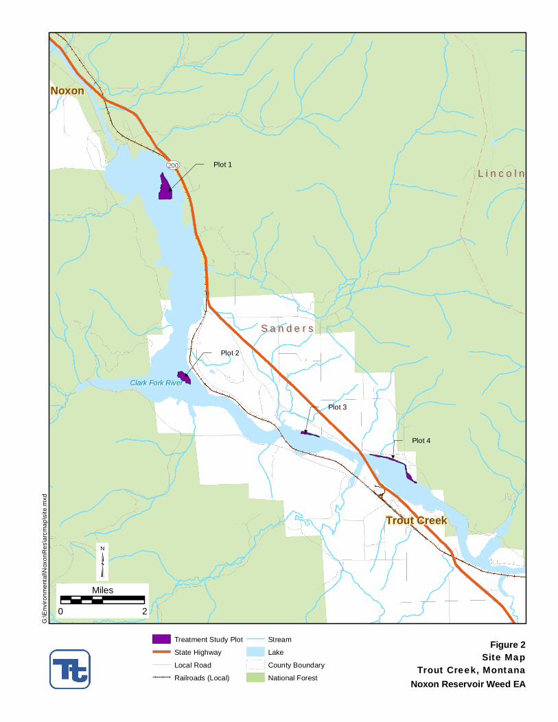
2.0 ALTERNATIVES ALTERNATIVE 1: NO ACTION ALTERNATIVE Under the no action alternative, there would be no dye and herbicide application research study. Therefore, the feasibility of using herbicides as a part of an integrated approach for controlling eurasian watermilfoil would not be known. The eurasian watermilfoil infestation would be allowed to persist within the Noxon Rapids and Cabinet Gorge Reservoirs and could potentially spread to other waterways within Montana. ALTERNATIVE 2: PROPOSED ACTION FOR DYE TESTING AND HERBICIDE APPLICATION The proposed action is to conduct a dye and herbicide research trial on eurasian watermilfoil and curlyleaf pondweed on up to 40 acres in Noxon Rapids Reservoir. The purpose of the research would be to determine effectiveness of herbicide treatment on controlling invasive non-native aquatic plants and feasibility of including herbicides in an integrated management approach. The field phases of the proposed work would occur from mid July to mid August 2009, and same period in July 2010. The US Army Engineer Chemical Control and Physiological Processes Team or other qualified researchers would oversee and conduct herbicide trials for controlling mixed stands of eurasian watermilfoil and curlyleaf pondweed in selected locations in Cabinet Gorge and/or Noxon Rapid Reservoirs, MT. Four study plots have been identified (Figure 2): Plots 2 and 3 are the dye and herbicide study plots and Plots 1 and 4 are the controls and will be monitored; however, no dye or herbicide would be applied. All of the study plots are located within Noxon Rapids Reservoir and are on Avista Utilities property. The plots are at the following locations:
Plot 1 - 115°42’33.89”W, 47°56’42.41”N within S3 and 10, T25N, R32W PMM;
Plot 2 - 115°41’59.32”W, 47°52’52.51”N within S34, T25N, R32W PMM;
Plot 3 - 115°37’20.65”W, 47°51’26.09”N within S7, T24N, R31W PMM; and,
Plot 4 - 115°35’50.19”W, 47°51’9.83”N within S8 and S9, T21N, R31W PMM. Water-exchange would be measured using the inert tracer dye, rhodamine (RWT), approved by use by USEPA in surface waters, using fluorometric instrumentation devises. Dye applications would be conducted using multi-depth water injection system (LitLine®, Clean Lakes Inc.), simulating an operational aquatic herbicide application calibrated for maximum delivery to targeted submersed plant stands. This would provide an estimate of herbicide contact time and can be matched with herbicide concentration/exposure times (CET) relationships in order to select the herbicide application rates most likely to provide control. An herbicide combination of systemic auxin (2,4-D or triclopyr) with endothall to control both eurasian milfoil and curlyleaf pondweed would be used, since these target plants occur as mixed stands in the reservoirs. Herbicide rates will be selected based on results of water-exchange evaluations conducted within 24-48 hrs of herbicide treatments. Herbicide rates
Plot 1
Plot 2
Plot 3
Plot 4
S a n d e r sS a n d e r s
L i n c o l nL i n c o l n
Trout CreekTrout Creek
NoxonNoxon
UV200
Clark Fork RiverClark Fork River
Figure 2Site MapTrout Creek, Montana
³0 2
Miles
Noxon Reservoir Weed EA
G:\E
nviro
nmen
tal\N
oxon
Res
\arc
map
\site
.mxd
Treatment Study Plot
State Highway
Local Road
Railroads (Local)
Stream
Lake
!!
!
! ! ! !!
!
!!!
County Boundary
National Forest
EA – Eurasian Watermilfoil / Curlyleaf Pondweed Research Project
Tetra Tech May 27, 2009 7
would not exceed maximum amounts allowed by the respective labels. Herbicide applications would be conducted using a multi-depth water injection system (LitLine®, Clean Lakes Inc.), calibrated for maximum delivery to targeted submersed plant stands. Water samples would be collected and analyzed for herbicide residues to determine actual CET values in the plots (and link with efficacy), and to monitor dissipation of herbicides within, and downstream of, the plots. Monitoring would be conducted in order to assess changes in plant communities. Monitoring events would occur pretreatment (2009), 6 weeks post treatment (2009), and 52 weeks post-treatment (2010) using quantitative techniques. A data report summarizing all aspects of the 2009 work would be submitted in February of 2010.
EA – Eurasian Watermilfoil / Curlyleaf Pondweed Research Project
Tetra Tech May 27, 2009 8
3.0 AFFECTED ENVIRONMENT AND ENVIRONMENTAL CONSEQUENCES
This section describes the current environmental conditions and environmental consequences of implementing the Proposed Action and No Action alternatives. For each resource, current conditions are described, followed by the direct, indirect and cumulative effects of the No Action and Proposed Action alternatives. The direct and indirect effects of the No Action alternative and cumulative effects are described to provide a baseline for evaluating effects of the action alternative. Direct effects are those effects that result from an action at the same time and place that the action occurs. Indirect effects are effects that result from an action but occur at a different time or place. Cumulative effects are the additive effects of the action and other ongoing and reasonable foreseeable activities. EXISTING AQUATIC WEED INFESTATIONS Analysis Area The analysis area for existing aquatic weed infestations is Noxon Rapids Reservoir and nearby reservoirs in the Lower Clark Fork Drainage. Noxon Rapids Reservoir is the location of the proposed dye and herbicide research trial. Affected Environment Eurasian watermilfoil is a non-native, submersed, perennial aquatic plant that forms dense mats of vegetation on the water’s surface. It is reported to have been introduced into the United States in the late 1880’s, possibly in the Chesapeake Bay Area in ship ballast (Aiken et al. 1979). The first documented discovery was in 1942 in Washington, D.C. (Couch and Nelson 1985). Under the Montana state classification system, noxious weeds are divided into four categories based on number of acres infested in the state and management criteria and is modified and updated as needed by the Statewide Noxious Weed List Advisory Committee, and determined by Rule of the Montana Department of Agriculture (MDA) under the provisions of the Montana County Weed Control Act. This classification ranks eurasian watermilfoil as a Category 3 noxious weed in Montana, which includes weeds that have either not been detected in the state or may be found in small, scattered, localized infestations. Management criteria for Category 3 noxious weeds include public awareness and education, early detection, and immediate action to eradicate infestations. Curlyleaf pondweed was declared noxious in Sanders County in November 2008, and is currently being considered for inclusion on the state noxious weed list. Infestations of eurasian watermilfoil are known to occur in adjoining states of Idaho, North Dakota, and South Dakota, and provinces of British Columbia, Alberta, and Saskatchewan, Canada. In Montana, eurasian watermilfoil was first confirmed at the Trout Creek Recreation area at Noxon Rapids Reservoir in June, 2007. In 2008, a vegetation inventory of Cabinet Gorge, Noxon Rapids, and Thompson Falls Reservoirs cursory was completed. This survey found eurasian watermilfoil occurred in shallow waters (<30 feet deep) and at other sites within Noxon Rapids and Cabinet Gorge Reservoir. This survey also quantified the presence and location of flowering rush (a Category 3 noxious weed in Montana) and curlyleaf pondweed (Madsen and Cheshier 2009). The survey did not detect eurasian watermilfoil in Thompson Falls Reservoir or flowering rush in Cabinet Gorge Reservoir. However, eurasian watermilfoil,
EA – Eurasian Watermilfoil / Curlyleaf Pondweed Research Project
Tetra Tech May 27, 2009 9
curlyleaf pondweed, and flowering rush were all present in Noxon Rapids Reservoir (Table 3-1).
TABLE 3-1 Acreage infested by invasive aquatic plants within Lower Clark Fork reservoirs
(Madsen 2009) Aquatic Weed Cabinet Gorge Noxon Rapids Thompson Falls
curlyleaf pondweed 195 401 72 eurasian watermilfoil 117 247 0 Flowering Rush 01 46 8 1 Flowering rush was observed established in Cabinet Gorge, but was not within the point intercept survey. Madsen and Cheshier’s (2009) survey found Noxon Rapids Reservoir had substantially more acreage infested with the three aquatic invasive plants than Cabinet Gorge Reservoir. At Noxon Rapids, curlyleaf pondweed was found scattered in much of the lower third, and as a dense band downstream of the North Shore boat launch. In the middle third of the reservoir, curlyleaf pondweed was found as a dense to scattered band, predominantly along the northern and/or eastern shores; depending on the orientation of the channel (the right-hand shore traveling downstream). In the upper third of the reservoir, the narrow shoreline band continued, again predominantly on the northern and/or eastern shore. An exception to this was Finley Flats, at this location a dense bed of curlyleaf pondweed was intermixed with native plants species (Madsen and Cheshier 2009). The distribution of eurasian watermilfoil at Noxon Rapids Reservoir was found to be as scattered plants or as a component of dense beds along each shore. Madsen and Cheshier (2009) recorded these beds in the lower portion of Noxon Rapids Reservoir and in the basin adjacent to the dam, just north of the two islands (Rock Island). The other bed was also discovered on a submerged island, at the junction of Marten Creek with the main reservoir arm, but towards the eastern shore. The third dense bed, mixed with curlyleaf pondweed, was located downstream of North Shore boat launch. The last bed is upstream of North Shore boat launch. There were dense infestations of eurasian watermilfoil observed in the lower third of the reservoir. ENVIRONMENTAL CONSEQUENCES Alternative 1: No Action Direct and Indirect Effects Under the No Action alternative, the proposed dye and aquatic herbicide research trial on eurasian watermilfoil and curlyleaf pondweed would not occur. Herbicide concentration/exposure times (CET) would remain an unknown for effective aquatic treatment of eurasian watermilfoil and curlyleaf pondweed. Effective herbicide application rates and impacts to non-target aquatic vegetation would not be determined; therefore, widespread, effective treatments of the current weed infestation could not occur. The existing aquatic weeds in Noxon Rapids and Cabinet Gorge Reservoirs would continue to expand with a significant potential to
EA – Eurasian Watermilfoil / Curlyleaf Pondweed Research Project
Tetra Tech May 27, 2009 10
spread to other waterbodies in Montana. The reservoirs would not likely remain in their current conditions and would continue to experience weed infestation. Cumulative Effects The No Action alternative would allow for the continuation of aquatic weed infestations and the potential spread of eurasian watermilfoil to additional waterbodies within Montana. An increase in weeds could spread into adjacent public and private areas that are currently not infested. The expansion of weed infestations would likely degrade native plant communities, fisheries and aquatic recreational activities. In addition, the cost of weed control would increase as the aquatic weed infestations are allowed to expand. Alternative 2 - Proposed Action Direct and Indirect Effects Under the Proposed Action, research would be conducted on the CET and aquatic herbicide effectiveness for treatment of eurasian watermilfoil and curlyleaf pondweed to determine use of approved herbicides as part of an integrated management approach. Upon completion of the proposed research project, the length of herbicide exposure and necessary concentration would be determined, which could support future plans for effective herbicide treatment of current infestations. The Proposed Action would result in the treatment of approximately 40 acres of aquatic weed infestations. Although, the knowledge gained from this treatment may allow for future treatments of weed infestation. Effective treatments could later be administered to other known infestations of eurasian watermilfoil and curlyleaf pondweed within Noxon Rapids and Cabinet Gorge Reservoirs. The spread of the eurasian watermilfoil could be contained and Montana waterbodies would be protected from the degrading infestations. Cumulative Effects The knowledge gained from completion of the Proposed Action would allow for effective herbicide treatment of eurasian watermilfoil and curlyleaf pondweed within Noxon Rapids and Cabinet Gorge Reservoirs. This component of the integrated management approach would assist in managing existing eurasian watermilfoil and curlyleaf pondweed infestations within Montana. The cumulative effects of the Proposed Action would be the protection of Montana waterbodies from eurasian watermilfoil and curlyleaf pondweed infestations and would also provide protection for other resources such as fish habitat, native plant communities, and recreation. Vegetation Analysis Area The analysis area for vegetation resources is vegetation within the 40 acre proposed herbicide and dye research trial area, vegetation within Noxon Rapids Reservoir and vegetation immediately adjacent to the boundary of the proposed action.
EA – Eurasian Watermilfoil / Curlyleaf Pondweed Research Project
Tetra Tech May 27, 2009 11
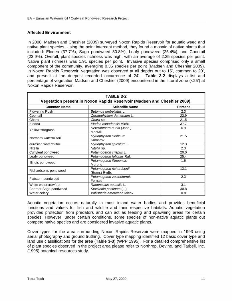
Affected Environment In 2008, Madsen and Cheshier (2009) surveyed Noxon Rapids Reservoir for aquatic weed and native plant species. Using the point intercept method, they found a mosaic of native plants that included: Elodea (37.7%), Sago pondweed 30.8%), Leafy pondweed (25.4%), and Coontail (23.9%). Overall, plant species richness was high, with an average of 2.25 species per point. Native plant richness was 1.91 species per point. Invasive species comprised only a small component of the community, averaging 0.35 species per point (Madsen and Cheshier 2009). In Noxon Rapids Reservoir, vegetation was observed at all depths out to 15’, common to 20’, and present at the deepest recorded occurrence of 24’. Table 3-2 displays a list and percentage of vegetation Madsen and Cheshier (2009) encountered in the littoral zone (<25’) at Noxon Rapids Reservoir.
TABLE 3-2 Vegetation present in Noxon Rapids Reservoir (Madsen and Cheshier 2009).
Common Name Scientific Name Percent Flowering Rush Butomus umbellatus L 2.3 Coontail Ceratophyllum demersum L. 23.9 Chara Chara sp. 21.5 Elodea Elodea canadensis Michx. 37.7
Yellow stargrass Heteranthera dubia (Jacq.) MacMill.
6.9
Northern watermilfoil Myriophyllum sibiricum Komarov
21.5
eurasian watermilfoil Myriophyllum spicatum L. 12.3 Nitella Nitella sp. 2.3 Curlyleaf pondweed Potamogeton crispus L. 20.0 Leafy pondweed Potamogeton foliosus Raf. 25.4
Illinois pondweed Potamogeton illinoensis Morong
1.5
Richardson's pondweed Potamogeton richardsonii (Benn.) Rydb.
13.1
Flatstem pondweed Potamogeton zosteriformis Fernald
2.3
White watercrowfoot Ranunculus aquatilis L. 3.1 Boerner Sago pondweed Stuckenia pectinata (L.) 30.8 Water celery Vallisneria americana Michx. 0.8
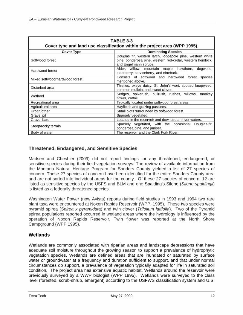
Aquatic vegetation occurs naturally in most inland water bodies and provides beneficial functions and values for fish and wildlife and their respective habitats. Aquatic vegetation provides protection from predators and can act as feeding and spawning areas for certain species. However, under certain conditions, some species of non-native aquatic plants out compete native species and are considered invasive aquatic plants. Cover types for the area surrounding Noxon Rapids Reservoir were mapped in 1993 using aerial photography and ground truthing. Cover type mapping identified 12 basic cover type and land use classifications for the area (Table 3-3) (WPP 1995). For a detailed comprehensive list of plant species observed in the project area please refer to Northrop, Devine, and Tarbell, Inc. (1995) botanical resources study.
EA – Eurasian Watermilfoil / Curlyleaf Pondweed Research Project
Tetra Tech May 27, 2009 12
TABLE 3-3
Cover type and land use classification within the project area (WPP 1995). Cover Type Dominating Species
Softwood forest Douglas fir, western larch, lodgepole pine, western white pine, ponderosa pine, western red-cedar, western hemlock, and Engelmann spruce.
Hardwood forest Alder, willow, mountain maple, hawthorn, dogwood, elderberry, serviceberry, and ninebark.
Mixed softwood/hardwood forest Consists of softwood and hardwood forest species mentioned above.
Disturbed area Thistles, oxeye daisy, St. John’s wort, spotted knapweed, common mullein, and sweet clover.
Wetland Sedges, spikerush, bullrush, rushes, willows, monkey flower, cattail.
Recreational area Typically located under softwood forest areas. Agricultural area Hayfields and grazing pastures. Urban/other Small plots surrounded by softwood forest. Gravel pit Sparsely vegetated. Gravel bars Located in the reservoir and downstream river waters.
Steep/rocky terrain Sparsely vegetated, with the occasional Douglas-fir, ponderosa pine, and juniper.
Body of water The reservoir and the Clark Fork River. Threatened, Endangered, and Sensitive Species Madsen and Cheshier (2009) did not report findings for any threatened, endangered, or sensitive species during their field vegetation surveys. The review of available information from the Montana Natural Heritage Program for Sanders County yielded a list of 27 species of concern. These 27 species of concern have been identified for the entire Sanders County area and are not sorted into individual areas for the county. Of these 27 species of concern, 12 are listed as sensitive species by the USFS and BLM and one Spalding's Silene (Silene spaldingii) is listed as a federally threatened species. Washington Water Power (now Avista) reports during field studies in 1993 and 1994 two rare plant taxa were encountered at Noxon Rapids Reservoir (WPP, 1995). These two species were pyramid spirea (Spirea x pyramidata) and twin clover (Trifolium latifolia). Two of the Pyramid spirea populations reported occurred in wetland areas where the hydrology is influenced by the operation of Noxon Rapids Reservoir. Twin flower was reported at the North Shore Campground (WPP 1995). Wetlands Wetlands are commonly associated with riparian areas and landscape depressions that have adequate soil moisture throughout the growing season to support a prevalence of hydrophytic vegetation species. Wetlands are defined areas that are inundated or saturated by surface water or groundwater at a frequency and duration sufficient to support, and that under normal circumstances do support, a prevalence of vegetation typically adapted for life in saturated soil condition. The project area has extensive aquatic habitat. Wetlands around the reservoir were previously surveyed by a WWP biologist (WPP 1995). Wetlands were surveyed to the class level (forested, scrub-shrub, emergent) according to the USFWS classification system and U.S.
EA – Eurasian Watermilfoil / Curlyleaf Pondweed Research Project
Tetra Tech May 27, 2009 13
Army Corps of Engineers. According to this survey, 119 wetlands were identified along Noxon Rapids Reservoir. A majority of these wetlands were classified as palustrine emergent (59%) and occurred on the shoreline fringe. The next prevalent classification was palustrine scrub-shrub (40%). The National Wetland Inventory database (http://www.nwi.fws.gov) for this area was searched but was found to be incomplete and did not identify any wetlands for the area. ENVIRONMENTAL CONSEQUENCES Alternative 1: No Action Direct and Indirect Effects Under the No Action alternative the herbicide and dye research trial would not occur. Aquatic weed species would continue to be present and spread. Over time this presence of aquatic weed species in Noxon Rapids Reservoir and the surrounding water bodies could change the aquatic environment to the extent that diversity and abundance of other native aquatic plants and nearby wetland and/or threatened, endangered, or sensitive plant species are adversely affected through competition for space and nutrients. Cumulative Effects The No Action alternative would allow for the continuation of aquatic weed infestations and the potential spread of eurasian watermilfoil to additional waterbodies within Montana. An increase in weeds could spread into adjacent public and private areas that are currently not infested. The expansion of weed infestations would likely continue to degrade aquatic native plant communities and may eventually impact wetland and rare plant communities. Alternative 2: Proposed Action Direct and Indirect Effects Without herbicide treatments as part of an integrated management approach, it is likely that aquatic weed infestations would continue to increase and spread, and possibly displace native plants, wetland plants, and threatened, endangered, and species of concern plants and their habitats. There is a minimal risk that native non-target plants may be impaired and/or killed by the herbicide application in this research project. However, these direct effects would most likely be localized and short-term. The short-term effects to non-target plant would be offset by long-term benefits of treatment to native plant communities. Emergent plants or wetlands aquatic plants bordering the treated area could be exposed. There may some drifting into other wetland communities or flow of water into palustrine or riparian environments. However, it is unlikely the impact would be measurable due to dilution effects of the herbicides and the mode of application. Direct and indirect effects would be minimized by properly implementing application rate and monitoring. Herbicide rates would be selected based on results of water-exchange evaluations conducted within 24-48 hrs of herbicide treatments. Herbicide rates would not exceed maximum amounts allowed by the respective labels. Herbicide applications would be conducted using a multi-depth water injection system (LitLine®, Clean Lakes Inc.), calibrated for maximum delivery to targeted submersed plant stands. Water samples would be
EA – Eurasian Watermilfoil / Curlyleaf Pondweed Research Project
Tetra Tech May 27, 2009 14
collected and analyzed for herbicide residues to determine actual CET values in the plots (and link with efficacy), and to monitor dissipation of herbicides within, and downstream of, the plots. Monitoring would be conducted in order to assess changes in plant communities. Monitoring events would occur pretreatment (2009), 6 weeks post treatment (2009), and 52 weeks post-treatment (2010) using quantitative techniques. A data report summarizing all aspects of the 2009 work would be submitted in February of 2010. Other studies using the same herbicides have shown native species were not impaired or killed after herbicide application to control eurasian watermilfoil in waterbodies that have reasonable flow rates (Netherland and Getsinger 1993; Getsinger et. al 1997). Overall, the Proposed Action is likely to benefit these native aquatic plants, wetland plants, and threatened, endangered, or sensitive plant species in the area by keeping habitat free of the aquatic weeds. If any threatened or sensitive plant species are identified before along the banks of Noxon Rapids Reservoir a protective buffer zone between the treated area and plant species of concern. Cumulative Effects Removal of eurasian watermilfoil and curlyleaf pondweed would improve habitat for native plant communities, wetland plants, and any threatened, endangered, or sensitive plants that may occur in the area. It is unlikely any of these plant communities would be adversely impacted by the Proposed Action alternative. Water Quality Analysis Area This water resource section includes both surface water and groundwater resources within the Noxon Rapids Reservoir and water bodies adjacent and downstream of the reservoir. Affected Environment The proposed action is within Noxon Rapids Reservoir. This reservoir is located in western Montana and northern Idaho on the lower Clark Fork River. Noxon Rapids Reservoir is located approximately 115 miles downstream of Missoula and 230 miles downstream of Butte, Montana, the two largest populated areas along the Clark Fork River. The climate at the proposed project area is dominated by Pacific maritime weather. Average annual precipitation ranges from 22.97 inches on the eastern side near Thompson Falls to 33.86 inches on the western side near Heron. Peak streamflow occurs in May and June. Summers are typically dry and warm and winters cool and moist. Surface Water Noxon Rapids Reservoir and the Clark Fork River are the principal surface water bodies in the proposed action area. Noxon Rapids Reservoir is created by the Noxon Rapids Dam on the Clark Fork River in northwestern Montana. The Noxon Rapids Dam consists of a 6,195 foot long, 260 foot high earthen-fill dam. At full capacity the reservoir creates a 7,940 surface acre area, 400,000 acre-feet impoundment with a maximum depth of 200 feet. The reservoir is 35.5 miles in length, and 2 miles wide at its widest point (WWP 1995). The operating capacity of Noxon Rapids Dam at full turbine flow and full pool is 466 MW (UNEP DDP 2009).
EA – Eurasian Watermilfoil / Curlyleaf Pondweed Research Project
Tetra Tech May 27, 2009 15
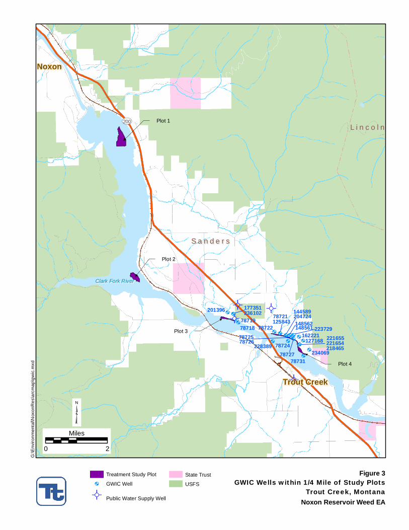
The Clark Fork River is approximately 360 miles long and the largest river by volume in Montana. It flows in a NW direction for approximately 340 miles from its origin at the confluence of Silver Bow and Warm Springs Creek near Anaconda, Montana to its mouth at the northeast end of Pend Oreille Lake in Idaho. The river drains an extensive region of approximately 22,000 square miles. Major tributaries include the Blackfoot, Bitteroot, and Flathead Rivers. Surface Water Development and Water Rights Avista (formerly WWP) installed turbines at the Noxon Rapids Dam in 1951, 1959, and 1976. The hydropower water rights for the Noxon Rapids Dam are owned by Avista Corporatoin and total 55,000+ cfs. Approximately 30% of the Clark Fork River Basin water rights are junior to Avista’s entitlements (DNRC 2004). Avista’s water rights are sufficient to utilize almost all of the flows leaving the basin. Clark Fork River flows greater than 50,000 cfs occur only 6-8% of the time over the entire 90 year period of record. Flows greater than 50,000 cfs generally occur 22 days in May and June of wetter years (DNRC 2004). Groundwater Exploitable groundwater resources within the lower Clark Fork River valley occur primarily as Quaternary basin-fill deposits and to a lesser extent fractured bedrock. The basin-fill contains unconfined aquifers and sequences of confined aquifers with numerous discontinuous confining layers. In places, confining sequences hydrologically isolate the aquifers; however, in most valleys water level data from different depths suggest that the basin-fill aquifers are well connected on a valley wide scale (LaFave 2006). Basin-fill sediments are comprised of modern Clark Fork River alluvium (Qal) in the valley bottom and older quaternary sediments (Qao) that form benches or terraces on the periphery. Colluvial and alluvial processes also contribute to basin-fill on valley margins. Glacial Lake Missoula high-energy flood deposits may be locally present throughout the lower Clark Fork River valley. Bedrock consists of well cemented or indurated rock that is commonly fractured. Most of the bedrock is comprised of metamorphosed carbonates, argillite, and quartzites of the Proterozoic Belt Supergroup; there are also localized occurrences of Cretaceous aged igneous intrusives of the Idaho Batholith. The presence of these fractures dissipates with depth, but deeper fractured zones do exist and numerous faults are present throughout the lower Clark Fork River valley. With almost no primary permeability in the bedrock, these fractures provide the secondary permeability from which groundwater is extracted. Groundwater Development and Water Rights Groundwater wells are the sole source water in the area for small community businesses and residential homes. No public water supply (PWS) systems utilize surface water from Noxon Rapids Reservoir as a source; however, shallow alluvial wells (Qal) completed near the Clark Fork River or Noxon Rapids Reservoir may hydraulically connected to the surface water and several PWS system are located within a short distance of the reservoir. There are approximately 289 wells on file with the Montana Bureau of Mines and Geology Ground-Water Information Center (GWIC) for the 58 Sections of land that either border or are inclusive of Noxon Rapids Reservoir (GWIC 2009). Of this number, 25 wells are located within a 1/4-mile radius of the test plots (Figure 3). The majority of these proximal wells are located near test Plot 4 (115°35’50.19”W, 47°51’9.83”N within S8 and S9, T21N, R31W PMM); however this is a control plot and will not receive any herbicide or dye application.
üü
ü
üü
üü
ü
ü
hh
hh
hhhh
h
h
hhhh h
hh
h
hhh
h
h
h
h
Plot 1
Plot 2
Plot 3
Plot 47873178727
787267872578722
787217871978718
236102
234069228389
221655
201396 177351
125843
21846522165478724
144589204724
127168162221
148561148562223729
S a n d e r sS a n d e r s
L i n c o l nL i n c o l n
Trout CreekTrout Creek
NoxonNoxon
UV200
Clark Fork RiverClark Fork River
Figure 3GWIC Wells within 1/4 Mile of Study PlotsTrout Creek, Montana
³0 2
Miles
Noxon Reservoir Weed EA
G:\E
nviro
nmen
tal\N
oxon
Res
\arc
map
\gw
ic.m
xd
Treatment Study Plot
h GWIC Well
ü Public Water Supply Well
State Trust
USFS
EA – Eurasian Watermilfoil / Curlyleaf Pondweed Research Project
Tetra Tech May 27, 2009 17
Usage for these wells are listed as domestic supply, public water supply and irrigation (GWIC 2009). The North Shore Campground has a transient non-community public water supply system (MT0062358) that serves up to 60 people. The source for the PWS is listed as Well#1. There have been numerous violations regarding coliform bacteria detections in the PWS required sampling program. No other information regarding the well completion depth or connectively with Noxon Rapids Reservoir surface water is supplied. The well is not listed with GWIC. No other public water supplies are located within ¼ mile of any of the three test plots. Water Quality Collection of water quality data on the middle and upper Clark Fork River is performed routinely by various state and federal agencies (WPP 1995). Overall water quality in Noxon Rapids and the Clark Fork River has been rated as good to excellent (WWP 1995). An identified water quality issue in the Clark Fork Drainage is heavy metals and excessive nutrient enrichment. In 1993, sediment samples were collected upstream of Noxon Rapids and at an adjoining tributary and analyzed for an array of metal concentrations. Results found metals do occur in the reservoir at slightly elevated concentrations but are not considered to occur at problematic levels (WPP 1995). These results are lower than concentrations reported for upstream locations. Nutrient levels entering the reservoir are low and water transparency has been found to be consistent with EPA criteria for mesotrophic water bodies (WPP 1995). Calculated nitrogen to phosphorus ratios indicate advantageous phosphorous limited nutrient condition throughout the growing season (WPP 1995). Physical water quality parameters in the reservoir including temperature, dissolved oxygen (DO), pH, conductivity, and water transparency are characteristic of the reservoir morphology and influent Clark Fork River. Noxon Rapids Reservoir is classified as a deep-water lacustrine (lake-like) water body. Waters in the reservoir have been shown to reflect elevated pH levels (>8.5) and high summer water temperatures (>66 F). It is common for Noxon Rapids Reservoir to stratify during warm summer months of low flow years. Dissolved oxygen concentrations in the summer of 1994 were recorded as high in all but the deepest waters (WPP 1995). In the upper 100 feet of the water column, DO levels were above 7 mg/l. The US EPA has listed the Clark Fork River subbasin (from mouth of Flathead River to Noxon Rapids dam) under the impaired waters list (Section 303d of the CWA). The 303d listing is for metals (other than mercury) (EPA 2009). The Montana Department of Environmental Quality (DEQ) is currently working on the Clark Fork River Total Mean Daily Load (TMDL). EPA lists the estimated TMDL submittal by DEQ as September 30, 2012, however no mention of the submittal date by DEQ is listed on their TMDL Program webpage. Water Quality Standards and Classifications Surface water quality standards have been established by the Montana Department of Environmental Quality (DEQ) through the Water Quality Bureau Circular 7 document (WQB-7).
EA – Eurasian Watermilfoil / Curlyleaf Pondweed Research Project
Tetra Tech May 27, 2009 18
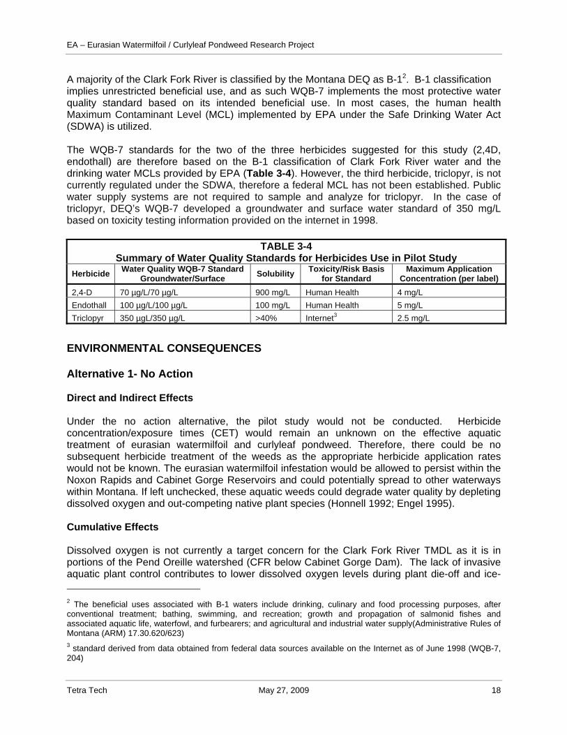
A majority of the Clark Fork River is classified by the Montana DEQ as B-12. B-1 classification implies unrestricted beneficial use, and as such WQB-7 implements the most protective water quality standard based on its intended beneficial use. In most cases, the human health Maximum Contaminant Level (MCL) implemented by EPA under the Safe Drinking Water Act (SDWA) is utilized. The WQB-7 standards for the two of the three herbicides suggested for this study (2,4D, endothall) are therefore based on the B-1 classification of Clark Fork River water and the drinking water MCLs provided by EPA (Table 3-4). However, the third herbicide, triclopyr, is not currently regulated under the SDWA, therefore a federal MCL has not been established. Public water supply systems are not required to sample and analyze for triclopyr. In the case of triclopyr, DEQ’s WQB-7 developed a groundwater and surface water standard of 350 mg/L based on toxicity testing information provided on the internet in 1998.
TABLE 3-4 Summary of Water Quality Standards for Herbicides Use in Pilot Study
Herbicide Water Quality WQB-7 Standard Groundwater/Surface Solubility Toxicity/Risk Basis
for Standard Maximum Application
Concentration (per label) 2,4-D 70 µg/L/70 µg/L 900 mg/L Human Health 4 mg/L Endothall 100 µg/L/100 µg/L 100 mg/L Human Health 5 mg/L Triclopyr 350 µgL/350 µg/L >40% Internet3 2.5 mg/L
ENVIRONMENTAL CONSEQUENCES Alternative 1- No Action Direct and Indirect Effects Under the no action alternative, the pilot study would not be conducted. Herbicide concentration/exposure times (CET) would remain an unknown on the effective aquatic treatment of eurasian watermilfoil and curlyleaf pondweed. Therefore, there could be no subsequent herbicide treatment of the weeds as the appropriate herbicide application rates would not be known. The eurasian watermilfoil infestation would be allowed to persist within the Noxon Rapids and Cabinet Gorge Reservoirs and could potentially spread to other waterways within Montana. If left unchecked, these aquatic weeds could degrade water quality by depleting dissolved oxygen and out-competing native plant species (Honnell 1992; Engel 1995). Cumulative Effects Dissolved oxygen is not currently a target concern for the Clark Fork River TMDL as it is in portions of the Pend Oreille watershed (CFR below Cabinet Gorge Dam). The lack of invasive aquatic plant control contributes to lower dissolved oxygen levels during plant die-off and ice- 2 The beneficial uses associated with B-1 waters include drinking, culinary and food processing purposes, after conventional treatment; bathing, swimming, and recreation; growth and propagation of salmonid fishes and associated aquatic life, waterfowl, and furbearers; and agricultural and industrial water supply(Administrative Rules of Montana (ARM) 17.30.620/623) 3 standard derived from data obtained from federal data sources available on the Internet as of June 1998 (WQB-7, 204)
EA – Eurasian Watermilfoil / Curlyleaf Pondweed Research Project
Tetra Tech May 27, 2009 19
covered portions of the year. This could in-turn affect native plant and fish species and could harm the recreation resources associated with the reservoir. The No Action alternative would allow for the continuation of aquatic weed infestations and the potential spread of eurasian watermilfoil to additional water bodies within Montana. An increase in weeds could spread into adjacent public and private areas that are currently not infested. The expansion of weed infestations would likely degrade dissolved oxygen levels, which is likely to negatively affect native plant communities, fisheries and aquatic recreational activities. Alternative 2 - Proposed Action The proposed action would involve the aquatic application of three registered aquatic herbicides in a pilot scale study coupled with a tracer dye study to determine aquatic dissipation rates so that proper CETs can be determined. Because aquatic herbicides have been deemed non-point sources of contaminates a Montana Pollutant Discharge Elimination System (MPDES) permit4 is not required. Instead, DEQ allows a short-term exemption for surface water quality standards for pesticide/herbicide application under a Section 308 Permit 75-5-308, MCA. Direct and Indirect Effects According to Jeff Ryan, Water Quality/Wetland Specialist with the DEQ Water Protection Bureau, as long as the 308 Permit applicant follows labeling instructions, appropriate dosing, and develops a monitoring program; the short term water quality variance generates no long-term adverse effects on water quality and fulfills its intended purpose- to control invasive aquatic plant species. In this case, the short-term water quality exceedances are conducted under a permitted and controlled situation where the resultant outcome is of higher beneficial use to the overall health of the aquatic ecosystem than any short term adverse effects generated by such use. According to U.S. Army Engineer Research and Development Center scientist, Kurt Getsinger (2009), application rates will be selected based on dye studies prior to treatments. Dye will determine water exchange and contact time. Maximum label rates are 5 mg/L endothall, 4 mg/L for 2,4-D, and 2.5 mg/L triclopyr. The pilot test will target lower concentrations if water exchange allows. Dissipation should be rapid, between a few hours to a few days. The maximum label concentrations are 50, 57, and 7 times over WQB-7 standards, respectively; however, with rapid dissipation and mixing outside of the pilot control plots, concentrations should be within water quality standards. Additionally, appropriate monitoring required by the 308 Permit will provide assurances that water quality impacts do not extend beyond the dosing area. The short-lived nature of these compounds under normal oxidizing environments and exposure to sunlight, any short-term increased health risk to humans or adverse environmental effects with the application of these herbicides within Noxon Rapids Reservoir is not expected.
4 all point sources of wastewater discharge are required to obtain and comply with MPDES permits.
EA – Eurasian Watermilfoil / Curlyleaf Pondweed Research Project
Tetra Tech May 27, 2009 20
Cumulative Effects The knowledge gained from completion of the Proposed Action would support future decisions on the most effective treatment of eurasian watermilfoil and curlyleaf pondweed within Noxon Rapids and Cabinet Gorge Reservoirs. This component of the integrated management approach would assist in managing current eurasian watermilfoil and curlyleaf pondweed infestations within Montana. The cumulative effects of the Proposed Action would be the protection of Montana water bodies from eurasian watermilfoil and curlyleaf pondweed infestations and this would also provide protection for other resources such as fish habitat, native plant communities, and recreation. Fisheries Analysis Area The fisheries resource analysis considers the proposed 40 acre project area, the entire water body of Noxon Rapids Reservoir and the Clark Fork River downstream of the proposed project. Affected Environment Fish species in Noxon Rapids Reservoir and the Clark Fork River include a mixture of native and introduced species. Montana Fish, Wildlife and Parks list the following species as present in Noxon Rapids Reservoir: westslope cutthroat trout, bull trout, and mountain whitefish. Introduced species include: brook trout, brown trout, lake trout, lake whitefish, largemouth bass, largescale sucker, longnose sucker, northern pike, northern pike minnow, peamouth, pumpkinseed, rainbow trout, redside shiner, smallmouth bass, walleye, yellow bullhead, yellow perch, and black bullhead. The same fish species present in the reservoir are found in the Clark Fork River with the addition of black bullhead, longnose dace, slimy sculpin, variable platyfish, and mottled sculpin. Dominant fish communities recorded in Noxon Rapids Reservoir catches include pumpkinseed, yellow perch, and northern squawfish (WPP 1995). Between 2004-2006, yearly gill net monitoring at Noxon Rapids Reservoir found yellow perch to consistently be the most abundant species sampled (52 %) of all species sampled in one stratum. Peamouth chub was the next most abundant fish captured by gill nets (Avista Corporation 2007). Since the development of the reservoir, fish management efforts have focused on fish stocking and hatcheries development to support a sports fishery. Though a small population of bull, westslope cutthroat, brown, and rainbow trout exists in the reservoir and the downstream portion of the Clark Fork River, these populations have not developed into a quality fishery due to habitat limitations (WPP 1995). Management of fisheries at the reservoir has placed an emphasis on establishing warm water species such as smallmouth and largemouth bass. These efforts have established the reservoir a reputation as a statewide and regional quality bass fishery. Threatened, Endangered and Sensitive Fish Species The native westslope cutthroat trout and bull trout are of special concern and both have designated special status. Bull trout are listed by the Fish and Wildlife Service as threatened, pursuant to the Endangered Species Act. Westslope cutthroat trout are listed as a sensitive
EA – Eurasian Watermilfoil / Curlyleaf Pondweed Research Project
Tetra Tech May 27, 2009 21
species by the United States Forest Service (USFS), Bureau of Land Management (BLM), and as a species of special concern by the Montana Chapter of American Fisheries Society, Montana Fish, Wildlife and Parks (MFWP), and the Montana Natural Heritage Program (MNHP). Both species have been observed in the reservoir, however, only a small population exists. ENVIRONMENTAL CONSEQUENCES Alternative 1: No Action Direct and Indirect Effects Under the No Action alternative, the approximately 40 acres of weeds would not be treated with herbicides and the appropriate CET and aquatic herbicide effectiveness would not be determined. Therefore, effective herbicide treatment of eurasian watermilfoil and curlyleaf pondweed within Noxon Rapids and Cabinet Gorge Reservoirs would not occur. Weed infestation would continue to expand and fish habitat would continue to be altered due to the infestations. The expanding infestations would especially degrade habitat for salmonids due to the potential reduction in spawning habitat. Cumulative Effects The cumulative impacts associated with the No Action alternative would entail a likely expansion of eurasian watermilfoil and curlyleaf pondweed, not only within Noxon Rapids and Cabinet Gorge Reservoirs, but potentially other waterbodies within Montana. This would result in a degradation of habitat for many fish species, particularly salmonid species. However, those fish species that prefer dense vegetation cover may benefit as the weed expansion would be a habitat enhancement. Alternative 2: Proposed Action Direct and Indirect Effects Impacts associated with the Proposed Action to fish and their habitat could occur through direct impacts from herbicides or post-treatment alteration of habitat. The herbicides potentially used in the Proposed Action include: one of two phenoxy herbicides, 2,4,D, or Triclopyr; and endothall. All of these herbicides have been researched extensively and approved by the Environmental Protection Agency (EPA). These herbicides are accepted as safe as long as they are administered within the recommended application rates and procedures. Below is a brief discussion of the herbicides proposed for use and their impacts on fish. 2,4-D - The average half-life of 2,4-D is 10 days in soil and less than 10 days in water, dependent upon other factors (e.g., temperature, soil condition) (Tu et al. 2001). The toxicity of 2,4-D varies by form of the chemical and organism. In fish, ester formulations tend to be more toxic, while amine salts are practically non-toxic. 2,4-D products should not be used when surface water temperatures less than 7° C (45°F) are anticipated at the time of application. Repeat applications where degradation may not have occurred can lead to concentrations of 2,4-D acid harmful to aquatic biota and should be limited (WSDE 2001). Acute exposure to 2,4-D can adversely impact aquatic species, especially benthic (bottom dwelling) organisms (WSDE 2001). Since the acute EEC (environmental effect concentration) is typically ~1.36 mg a.i./L (and can be as high as 4.8 mg a.i./L), the acute risk quotient (the ratio of exposure
EA – Eurasian Watermilfoil / Curlyleaf Pondweed Research Project
Tetra Tech May 27, 2009 22
concentration divided by an effects concentration) is above the level of concern of 0.1 for the most sensitive benthic species tested (WSDE 2001). DMA formulations of 2,4-D should be used whenever possible rather than BEE formulations of 2,4-D because of DMA reduced toxicity to benthic organisms (WSDE 2001). The lowest effective concentration to prevent acute toxicity should be used. Triclopyr – Triclopyr acid has been reported to be practically non-toxic to rainbow trout (Lethal Concentration (LC) 50 = 117 ppm a.e. for rainbow trout) and bluegill sunfish (96-hour LC50 of 148 ppm a.e.) (WSDE 2001). Risk Assessments indicate that triclopyr (triclopyr TEA) may be used safely at concentrations up to 2.5 ppm a.e. when most species of fish and invertebrates are present (WSDE 2001). The 96-hour LC50 for all verified studies on fish is greater than 82 ppm a.e. Therefore, the Risk Quotient for the most sensitive species of fish is below the acute levels of concern (0.1) for protection of the biota. The Acute Risk Quotient for triclopyr TEA using rainbow trout (Oncorhynchus mykiss) is 0.03 (2.5 ppm a.e./82 ppm a.e.) (WSDE 2001). Both fish and aquatic invertebrate biota should not be at high risk from the use of triclopyr TEA to control aquatic weeds (WSDE 2001). Endothall – Endothall in the form of the acid, dipotassium endothall salt or disodium endothall should not chronically affect fish or invertebrates. Since the most sensitive species (Chinook Salmon) has an LC50 of 23 mg a.e./L, the predicted NOEC (NOEC = the No Observable Effects Concentration) would be 3.6 mg a.e./L based on a Acute LC50 to Chronic NOEC ratio of 6.4 for the tested species (WSDE 2001). The value of 3.6 mg a.e./L does not differ significantly from the empirically obtained values of 5 mg a.e./L for rainbow trout and Daphnia magna. The chronic EEC ranges between 0.06 and 0.14 mg a.e. (WSDE 2001). Therefore, the chronic risk quotient does not exceed the chronic level of concern of 1.0 (0. 06 ppm a.e./3.6 ppm a.e. = 0.017). Therefore, one can anticipate that even the most sensitive species in the biota should not be affected by endothall acid or inorganic endothall salts (WSDE 2001). Of the three herbicides potentially applied in the Proposed Action, 2,4,D poses the greater toxicity risk to fish if applied in large doses over an extended period of the time. Under the Proposed Action, all herbicides would be strictly administered under the manufacturer’s recommendations and extended, repeat exposure of herbicides would not occur. Therefore, fish within the analysis area would not be directly impacted by the proposed herbicide applications. Maximum label rates are 5 mg/L endothall, 4 mg/L for 2,4-D, and 2.5 mg/L triclopyr. The proposed pilot test will target lower concentrations if water exchange allows. Dissipation should be rapid, between a few hours to a few days. With rapid dissipation and mixing outside of the pilot control plots, concentrations should be within water quality standards and, therefore, should not impact fish. Additionally, appropriate post-treatment monitoring will provide assurances that water quality impacts would be minimized. Based on the toxicity/risk basis and the short-lived nature of these compounds under normal oxidizing environments and exposure to sunlight, any short-term increased health risks to fish or adverse environmental effects with the application of these herbicides within Noxon Rapids Reservoir is not expected. Implementation of the Proposed Action would alter habitat for fish species within the three plots treated by herbicides. The most obvious habitat altercation would be the reduction in herbaceous habitat that provides cover for a variety of fish species within the analysis area. However, the Proposed Action would impact a minimal amount of this habitat type given the amount of available habitat within the analysis area; therefore, this would not negatively impact fish that utilize the treated areas, only displace them.
EA – Eurasian Watermilfoil / Curlyleaf Pondweed Research Project
Tetra Tech May 27, 2009 23
Exposure of living plant tissue to herbicides usually results in indirect effects. When plants start to die, there is often a drop in the dissolved oxygen content associated with the decay of the dead and dying plant material. A significant reduction in dissolved oxygen concentration could result in aquatic animal mortality or a shift in dominant forms to those more tolerant of anaerobic conditions. There may also be changes in the levels of plant nutrients due to release of phosphate from the decaying plant tissue and anoxic hypolimnion. Also, ammonia may be produced from the decay of dead and dying plant tissue and may reach levels toxic to the resident biota. Ammonia may be further oxidized to nitrite (which is also toxic to fish), and the almost nontoxic, nitrate. The presence of these nutrients may cause an alga bloom to occur. While the decaying plant material associated with the Proposed Action may temporarily alter water chemistry within the treated plots, the treated plots represent a small area relative to the fish habitat within the analysis area; therefore, water chemistry impacts would be quickly diluted. While the temporary impacts to water chemistry may displace fish within the area of the treated plots, the displacement due to these impacts would be temporary and as water chemistry stabilizes, impacts to fish would diminish. Threatened, Endangered and Sensitive Fish Species The Proposed Action would not pose unique impacts to threatened, endangered and sensitive fish species within the analysis area. Direct and indirect impacts are the same as those discussed above. The Proposed Action would have no effect on threatened or endangered fish within the analysis area. While some sensitive fish species may temporarily be displaced due to the Proposed Action, displacement would be temporary and the viability of their populations would not be impacted. Cumulative Effects Overall, the Proposed Action would have positive cumulative effects on fish and their habitat. Upon completion of the Proposed Action, the appropriate CET and aquatic herbicide effectiveness would be determined. Therefore, the potential to use herbicides as part of an integrated weed management program for treatment of eurasian watermilfoil and curlyleaf pondweed within Noxon Rapids and Cabinet Gorge Reservoirs could be evaluated based on site specific research results. Control and eradication of eurasian watermilfoil and curlyleaf pondweed would protect native fish habitat, not only within Noxon Rapids and Cabinet Gorge Reservoirs, but within all waterbodies within the Montana. Wildlife Analysis Area The analysis area for wildlife resources is the 40 acre proposed herbicide and dye research trial area, Noxon Rapids Reservoir, and the area adjacent to proposed action. Affected Environment In 1993 and 1994, WWP performed a wildlife baseline inventory of the Noxon Rapid Reservoir area. This inventory documented a diverse assortment of over 120 wildlife species utilizing the area. This survey observed a range of butterflies, amphibians, reptiles, breeding songbirds, waterbirds, raptors, and a variety of mammal species including big game species such as black bear, elk, moose, and deer. For detailed results and descriptions from these surveys refer to the 1995 WWP report.
EA – Eurasian Watermilfoil / Curlyleaf Pondweed Research Project
Tetra Tech May 27, 2009 24
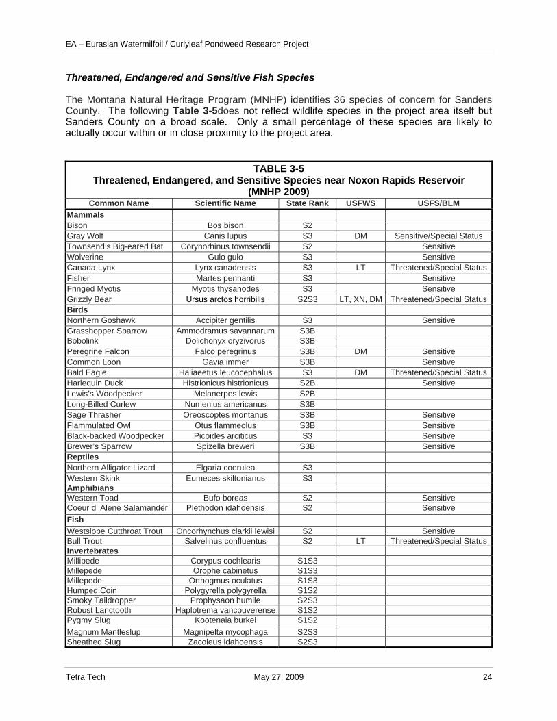
Threatened, Endangered and Sensitive Fish Species The Montana Natural Heritage Program (MNHP) identifies 36 species of concern for Sanders County. The following Table 3-5does not reflect wildlife species in the project area itself but Sanders County on a broad scale. Only a small percentage of these species are likely to actually occur within or in close proximity to the project area.
TABLE 3-5 Threatened, Endangered, and Sensitive Species near Noxon Rapids Reservoir
(MNHP 2009) Common Name Scientific Name State Rank USFWS USFS/BLM
Mammals Bison Bos bison S2 Gray Wolf Canis lupus S3 DM Sensitive/Special Status Townsend’s Big-eared Bat Corynorhinus townsendii S2 Sensitive Wolverine Gulo gulo S3 Sensitive Canada Lynx Lynx canadensis S3 LT Threatened/Special StatusFisher Martes pennanti S3 Sensitive Fringed Myotis Myotis thysanodes S3 Sensitive Grizzly Bear Ursus arctos horribilis S2S3 LT, XN, DM Threatened/Special StatusBirds Northern Goshawk Accipiter gentilis S3 Sensitive Grasshopper Sparrow Ammodramus savannarum S3B Bobolink Dolichonyx oryzivorus S3B Peregrine Falcon Falco peregrinus S3B DM Sensitive Common Loon Gavia immer S3B Sensitive Bald Eagle Haliaeetus leucocephalus S3 DM Threatened/Special StatusHarlequin Duck Histrionicus histrionicus S2B Sensitive Lewis’s Woodpecker Melanerpes lewis S2B Long-Billed Curlew Numenius americanus S3B Sage Thrasher Oreoscoptes montanus S3B Sensitive Flammulated Owl Otus flammeolus S3B Sensitive Black-backed Woodpecker Picoides arciticus S3 Sensitive Brewer’s Sparrow Spizella breweri S3B Sensitive Reptiles Northern Alligator Lizard Elgaria coerulea S3 Western Skink Eumeces skiltonianus S3 Amphibians Western Toad Bufo boreas S2 Sensitive Coeur d’ Alene Salamander Plethodon idahoensis S2 Sensitive Fish Westslope Cutthroat Trout Oncorhynchus clarkii lewisi S2 Sensitive Bull Trout Salvelinus confluentus S2 LT Threatened/Special StatusInvertebrates Millipede Corypus cochlearis S1S3 Millepede Orophe cabinetus S1S3 Millepede Orthogmus oculatus S1S3 Humped Coin Polygyrella polygyrella S1S2 Smoky Taildropper Prophysaon humile S2S3 Robust Lanctooth Haplotrema vancouverense S1S2 Pygmy Slug Kootenaia burkei S1S2 Magnum Mantleslup Magnipelta mycophaga S2S3 Sheathed Slug Zacoleus idahoensis S2S3
EA – Eurasian Watermilfoil / Curlyleaf Pondweed Research Project
Tetra Tech May 27, 2009 25
ENVIRONMENTAL CONSEQUENCES Alternative 1: No Action Direct and Indirect Effects The No Action alternative would not impact terrestrial wildlife or wildlife habitat within the analysis area. Aquatic habitat would be impacted; refer to the Fisheries Section for a discussion of impacts to aquatic habitat. Cumulative Effects The No Action alternative would have no impact on wildlife species within the analysis area. Given that there are no impacts or effects, there would be no cumulative effects. Alternative 2: Proposed Action Direct and Indirect Effects Impacts to wildlife associated to the Proposed Action would occur in the event that wildlife came in direct contact with contaminated water. The likelihood of this occurring is small due to the isolated treatment plots and rapid dissipation and mixing outside of the treatment plots. In the even that contaminated water does come in contact with wildlife, health impacts would be very unlikely. All herbicides would be strictly administered under the manufacturer’s recommendations and extended, repeat exposure of herbicides would not occur. Maximum label rates are 5 mg/L endothall, 4 mg/L for 2,4-D, and 2.5 mg/L triclopyr. The proposed pilot test will target lower concentrations if water exchange allows. Dissipation should be rapid, between a few hours to a few days. With rapid dissipation and mixing outside of the pilot control plots, concentrations should be within water quality standards and, therefore, should not impact wildlife. Additionally, appropriate post-treatment monitoring will provide assurances that water quality impacts would be minimized. Based on the toxicity/risk basis and the short-lived nature of these compounds under normal oxidizing environments and exposure to sunlight, any short-term increased health risks to wildlife or adverse environmental effects with the application of these herbicides would not be expected to occur. Many studies have been run on these products to ensure their safety to wildlife and the label directions and warnings reflect the results of these studies. Therefore, if the chemicals are applied according to the label, the effect on terrestrial wildlife should be minimal (WSDE 2001). Threatened, Endangered and Sensitive Wildlife Species The Proposed Action would not pose unique impacts to threatened, endangered and sensitive wildlife species within the analysis area. The direct and indirect impacts are the same as those discussed above. The Proposed Action would have no effect on threatened or endangered wildlife within the analysis area. Cumulative Effects The Proposed Action would have no impact on wildlife species within the analysis area. Given that there are no impacts or effects, there would be no cumulative effects.
EA – Eurasian Watermilfoil / Curlyleaf Pondweed Research Project
Tetra Tech May 27, 2009 26
Recreation The analysis area for recreation is Noxon Rapids Reservoir. The area surrounding Noxon Rapids Reservoir is characterized by rural, residential and agriculture with interspersed tracts of undeveloped land and is surrounded by the Panhandle, Kootenai, and Lolo National Forests (WPP 1995). Affected Environment Noxon Rapids Reservoir is located in a geographical region that encompasses several popular recreation destinations (Glacier National Park, Lake Coeur d’ Alene). Due to this, recreation facilities and opportunities at the reservoir are more of a local stature that provide nearby, opportunities for local residents of Sanders County, Montana and northern Idaho. Data collected in 1993 and 1994 found 50% of the users were local (WPP 1995). Noxon Rapids Reservoir is not situated in a remote setting. Paved and dirt roads border both sides of the reservoir for most of its entire length. Motorized use is allowed with the exception of restricted access areas designed to protect resources and public accessibility to water at Noxon Rapids Reservoir is widely available. Six developed recreation use areas including campgrounds, day use areas, and boat ramps exist along Noxon Rapids Reservoir. As well as these developed sites, 12 additional undeveloped sites have been identified where recreation activities occur. Recreation sites closest to the Proposed Action are the North Shore Day Use and Campground and Nurreau Flats and South Shore. North Shore is immediately downstream of plot 3 and Nurreau Flats and South Shore are within 0.5 miles of plot 4. All other recreation sites are 2 miles or more up or downstream (Burky pers. comm.). Developed and undeveloped sites in the project area provide opportunities for water-based and other recreation activities (WPP 1995). Activities documented in the project area include: fishing, motor boating, RV and tent camping, picnicking, swimming, sightseeing, walking, relaxing, nature watching, water skiing, windsurfing, canoeing, tubing, sunbathing, kayaking, and ice fishing. Observational surveys of recreational activity at recreation sites were conducted by WWP in 1993 and 1994. These studies found fishing, motor boating, relaxing, and swimming the most popular activities of the summer season (WPP 1995). Less popular activities included canoeing, kayaking, windsurfing, and nature watching. Winter recreational use of the area is low and appears to be dependent on weather conditions (WPP 1995). Traffic counters were installed and monitored at Noxon Rapids Dam overlook between June 1 and September 18, 1994. Though these counts are estimates and may not actually represent the true use; 2,548 vehicles were recorded during this time frame. The highest number of motorboats recorded in a 1994 count at Noxon Rapids Reservoir was 24 with the mean number 9.1 (WPP 1995). Overall, the Proposed Action area provides access for recreation activities such as fishing, motorboating, camping, swimming, and sightseeing. Current use of the area for recreation activities is estimated at 65-70 % capacity (Burky pers. comm.). Future usage will more than likely bring an increase in both user numbers and types of recreational activities. This projection is based on the 2000 U.S. Census Bureau data which indicated a 7.9 % increase in the population of Sanders County, Montana and an increase in the real estate market.
EA – Eurasian Watermilfoil / Curlyleaf Pondweed Research Project
Tetra Tech May 27, 2009 27
ENVIRONMENTAL CONSEQUENCES Alternative 1: No Action Direct and Indirect Effects Under the No Action alternative, the proposed dye and aquatic herbicide research trial on eurasian watermilfoil and curlyleaf pondweed would not occur. Recreational opportunities and activities at Noxon Rapids Reservoir could be directly impacted if a concerted effort to control eurasian watermilfoil and curlyleaf pondweed does not occur. An indirect effect of failure to control large floating beds of aquatic weeds from swimming areas could result in swimmers being entangled in the floating beds and potentially resulting in drowning or injury. Boaters’ motors could become entangled with the floating beds and the floating beds of aquatic weeds could serve as breeding grounds for mosquitoes. Cumulative Effects Over time an increase in aquatic weeds could restrict waterways and degrade water quality, resulting in an adverse impact to recreational use. With establishment in Noxon Rapids Reservoir and nearby reservoirs, eurasian watermilfoil and curlyleaf pondweed may spread to other waterways in the area and throughout Montana. Recreation activities such as boating, swimming, and fishing could be halted in areas that are greatly infested with aquatic weeds. Other non-infested boat launching areas around the lake may become impacted since infestations generally begin around boat launching areas where plant fragments are accidentally introduced by boats from other infected areas. Alternative 2: Proposed Action Direct and Indirect Effects Under the Proposed Action, research would be conducted on the CET and aquatic herbicide effectiveness for treatment of eurasian watermilfoil and curlyleaf pondweed to determine use of approved herbicides as part of an integrated management approach. Knowledge of these parameters could help control these invasive aquatic weeds and maintain access to boating, fishing, and swimming areas where water resource activities may become restricted in the future due to rapid spread and infestation. The Proposed Action is expected to have a direct positive impact on recreational use in the area. The herbicides selected in the research trial are not expected to cause adverse impacts to recreational activities such as fishing, boating, or swimming. Recreational use may be temporarily inconvenienced during application of herbicides and 24 hours after application. There is a slight potential for direct effects to recreational users. These effects could result from chemical exposure through contact, ingestion, or inhalation during activities such as boating, fishing, or swimming. To mitigate for this potential effect proper signage and notices in treatment and adjacent areas would be posted. A 24-hour swimming and fishing advisory would be posted in treated areas. Swimming and fishing outside the treatment area would not have any restrictions. Boaters will be advised to wait until the application is completed before entering the treatment area. Indirect effects post-treatment could occur due to different dissipation rates of the herbicides. Dissipation half-life for the proposed herbicides in water has been shown to vary from less than one day to approximately 7.5 days. Studies of spot
EA – Eurasian Watermilfoil / Curlyleaf Pondweed Research Project
Tetra Tech May 27, 2009 28
treatments at Lake Seminole for control of eurasian watermilfoil did not detect herbicides at sites located more than 1.5 Km (~5000 feet) downstream (WSDE, 2001). Cumulative Effects The knowledge gained from completion of the Proposed Action would allow for effective herbicide treatment of eurasian watermilfoil and curlyleaf pondweed within Noxon Rapids and Cabinet Gorge Reservoirs. This component of the integrated management approach would assist in managing current eurasian watermilfoil and curlyleaf pondweed infestations within Montana. The cumulative effects of the Proposed Action would be the protection of Montana waterbodies from eurasian watermilfoil and curlyleaf pondweed infestations and would likely be beneficial to recreational users of the reservoir. Cumulative effects may also result in educating the public on the benefits of controlling aquatic weed species and preventing their spread. Soil Resources Analysis Area The analysis area for evaluating potential impacts to soil resources is the area adjacent to the four proposed plots and along the reservoir boundaries. This analysis area is adequate for evaluating direct, indirect, and cumulative effects from the project because it is unlikely the project will impact soils surrounding the reservoir. Affected Environment Soils map data obtained from the Natural Resources Conservation Service (http://soildatamart.nrcs.usda.gov/) were used to evaluate potential impacts of the proposed action. The distribution of dominant soil types in the project area are geographically intermixed and range in texture from rock outcrops to gravelly-ashy-silt loam. Dominant map unit symbols and map unit names identified in the project area include: (251) Andic Dystrochrepts-Rock outcrop complex, breaklands, (632 F) Rockhill-Rock outcrop complex, 15 to 60 percent slopes, and (87F) Stevie gravelly ashy silt loam, 35 to 60 percent slopes. These soils are well drained and formed in weathered metasedimentary loamy slope alluvium and volcanic ash over colluvium and are the Capacity of the most limiting layer to transmit water is rate as ,moderately high to high. Depth to water table is greater than 80 inches with frequency of flooding and ponding none. Descriptively these soil profiles range from gravelly silt loam, to very gravelly very fine sandy loam, or cobbly sandy loam. ENVIRONMENTAL CONSEQUENCES Alternative 1: No Action Direct and Indirect Effects Under the No Action alternative, the proposed research dye and herbicide trial would not occur. Therefore, no direct or indirect effects to soil would occur in the analysis area.
EA – Eurasian Watermilfoil / Curlyleaf Pondweed Research Project
Tetra Tech May 27, 2009 29
Cumulative Effects The No Action alternative would not result in any change to soil conditions within the area therefore there would be no cumulative effects from the research dye and herbicide trial. Alternative 2: Proposed Action Direct and Indirect Effects The Proposed Action would not disturb soils along the four proposed plots and along the reservoir boundaries. Due to the proposed mode of application and the fact these herbicides do not readily bind to soil, chemicals in the soil sediment is not of concern. Cumulative Effects The Proposed Action alternative is not expected to affect soils along the four proposed plots and along the reservoir boundaries, and will therefore have no cumulative effects on soils. Air Quality Analysis Area The analysis area for air quality is Noxon Rapids Reservoir and nearby reservoirs in the Lower Clark Fork Drainage. Affected Environment The Noxon Rapids Reservoir project area is dominated by Pacific maritime weather, characteristic of much of the Pacific Northwest, with a secondary continental influence (WPP 1995). Typically the area is characterized as having cold winter and warm summer days. The coldest weather occurs when continental air masses from Canada move into the region. The majority of precipitation occurs between November and January. The State of Montana and the federal government have established ambient air quality standards for criteria air pollutants. Criteria pollutants are carbon monoxide (CO), lead (Pb), sulfur dioxide (SO2), particulate matter smaller than 10 microns (PM10), particulate matter smaller than 2.5 microns (PM2.5), ozone, and nitrogen dioxide (NO2). Ambient air quality standards must not be exceeded in areas accessible to the general public. Table 3-6 lists the national primary air quality standards which Montana has adopted by rule. National primary standards are the levels of air quality necessary, with an adequate margin of safety, to protect public health. Attainment concentrations or status for pollutants within the proposed action area is determined by monitoring levels of criteria pollutants for which National Ambient Air Quality Standards (NAAQS) and Montana Ambient Air Quality Standards exist. Attainment or unclassified designation means no violations of Montana or national air quality standards have been documented in the region.
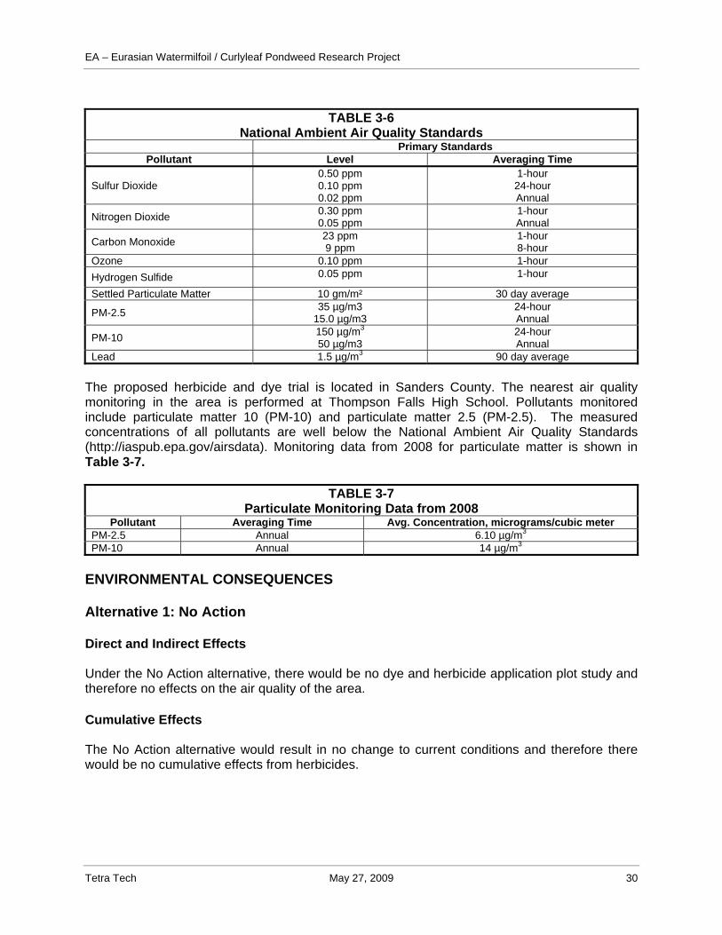
EA – Eurasian Watermilfoil / Curlyleaf Pondweed Research Project
Tetra Tech May 27, 2009 30
TABLE 3-6
National Ambient Air Quality Standards Primary Standards
Pollutant Level Averaging Time
Sulfur Dioxide 0.50 ppm 0.10 ppm 0.02 ppm
1-hour 24-hour Annual
Nitrogen Dioxide 0.30 ppm 0.05 ppm
1-hour Annual
Carbon Monoxide 23 ppm 9 ppm
1-hour 8-hour
Ozone 0.10 ppm 1-hour Hydrogen Sulfide 0.05 ppm 1-hour
Settled Particulate Matter 10 gm/m² 30 day average
PM-2.5 35 µg/m3 15.0 µg/m3
24-hour Annual
PM-10 150 µg/m3
50 µg/m3 24-hour Annual
Lead 1.5 µg/m3 90 day average The proposed herbicide and dye trial is located in Sanders County. The nearest air quality monitoring in the area is performed at Thompson Falls High School. Pollutants monitored include particulate matter 10 (PM-10) and particulate matter 2.5 (PM-2.5). The measured concentrations of all pollutants are well below the National Ambient Air Quality Standards (http://iaspub.epa.gov/airsdata). Monitoring data from 2008 for particulate matter is shown in Table 3-7.
TABLE 3-7 Particulate Monitoring Data from 2008
Pollutant Averaging Time Avg. Concentration, micrograms/cubic meter PM-2.5 Annual 6.10 µg/m3 PM-10 Annual 14 µg/m3
ENVIRONMENTAL CONSEQUENCES Alternative 1: No Action Direct and Indirect Effects Under the No Action alternative, there would be no dye and herbicide application plot study and therefore no effects on the air quality of the area. Cumulative Effects The No Action alternative would result in no change to current conditions and therefore there would be no cumulative effects from herbicides.
EA – Eurasian Watermilfoil / Curlyleaf Pondweed Research Project
Tetra Tech May 27, 2009 31
Alternative 2: Proposed Action Direct and Indirect Effects The general air quality in the area surrounding Noxon Rapids Reservoir is good and is well below the national ambient air quality standards for PM-2.5 and PM-10. Direct effects to air quality from the proposed action would likely be nonexistent. Herbicides involved in the research trial of eurasian watermilfoil and curlyleaf pondweed are not expected to have an appreciable affect on air quality because of the small size of the areas treated, amount of herbicide used, the mode of application (subsurface injection into water), and the rapid dilution of herbicides in the air. Cumulative Effects According to the EPA, herbicide residues in air can be from three sources: 1) drift at the time of application; 2) dispersal of herbicides due to wind erosion after application; and 3) volatilization from treated areas (soil, water, plants, etc.) or areas contaminated by herbicide residues in air. Due to the manner in which the herbicides would be applied, it is unlikely air quality would be impacted and cumulative air quality effects would not be expected to result in violations of particulate ambient air quality standards. Human Health Analysis Area This section addresses the potential effects of implementing the proposed action human health and safety. This section focuses on potential health issues associated with herbicide use, as well as other possible health and safety concerns to project workers, nearby residents, and others using the reservoir for various activities. The Region of Influence (ROI) considered in this section is Noxon Rapids Reservoir and nearby reservoirs in the Lower Clark Fork Drainage. Affected Environment The Proposed Action alternative proposes herbicide and dye research trials at plots within Noxon Rapids Reservoir. The area surrounding the reservoir may include populations or land uses that could be sensitive to the Proposed Action. Residential or commercial business areas that are in close proximity to areas treated with herbicide could be impacted as well as recreational users as well as populations in nearby reservoirs. ENVIRONMENTAL CONSEQUENCES Alternative 1: No Action Direct and Indirect Effects The No Action alternative would not directly or indirectly effect human health.

EA – Eurasian Watermilfoil / Curlyleaf Pondweed Research Project
Tetra Tech May 27, 2009 32
Cumulative Effects The No Action alternative would not result changes to current human health conditions and therefore there would be no cumulative effects to human health. Alternative 2: Proposed Action Direct and Indirect Effects Only herbicides that have been approved by the EPA would be used in the research trial. The herbicides (2,4-D or triclopyr with endotholl) proposed for the research trial are water-soluble and are rapidly eliminated from humans and do not concentrate in fatty tissues and do not significantly bioaccumulate. Most human chemical exposures are either acute (one time exposure) or subchronic (exposure to a chemical for a few days or weeks). Research has shown use of these herbicides presents little to no risk to human health from acute exposures through dermal contact with water or ingestion of fish. Dermal contact with treated vegetation may present limited risk exposure if contact is within one hour after application. 24-hours post application dermal contact is essentially nonexistent. Margins of safety for all acute exposure scenarios are greater than “100”. This rating implies risk of systemic, teratogenic, or reproductive effects to humans is negligible. Chronic exposure assessments indicate human health should not be adversely impacted from chronic exposure to these chemicals via ingestion of fish, ingestion of surface water, incidental ingestion of sediments, dermal contact with sediments, or dermal contact with water (swimming). Acute, subchronic and chronic toxicology investigations reveal the acid, amine salts and esters in these herbicides have similar degrees of low systemic toxicity. Amine salts and esters are metabolized to the acid and undergo rapid excretion by the kidneys. These herbicides do not accumulate in organisms; however when the administered dose exceeds the threshold for normal renal function occurs resulting in possible systemic poisoning. Based on research of these aquatic herbicides, label directed use poses little concern for causing adverse health effects to people. (WSDE, 2001) Direct effects to those involved in the herbicide application may result from exposure through chemical contact, ingestion, or inhalation. Applicators’ may be exposed during the mixing of herbicide formulations and addition of surfactants and during application operations. However, little to no inhalation exposure is expected due to the methods of application. Acute inhalation overexposure to these herbicides in animal studies has demonstrated signs of respiratory tract irritation. Symptoms did not persist beyond 3-7 days post exposure, nor were there any deaths. Potential for exposure will be minimized through use of appropriate personal protective equipment and having only qualified personnel handling the herbicides. Exposure to general public health under this alternative is very limited because exposures exceeding a threshold of concern will not be used and based on facts about chemistry of the herbicides considered for use and the mechanisms by which exposures of concern might occur. There is no possibility of a person being directly sprayed given the application methods considered for this project. Cumulative Effects The cumulative effects of aquatic herbicides proposed in this research trial in regards to human health are not expected to result in adverse health effects if chemicals are utilized properly with label directions. Herbicide application under this research trial will provide for a safer, better coordinated alternative than the practice of random application of unidentified herbicides by local residents and water recreation users.
EA – Eurasian Watermilfoil / Curlyleaf Pondweed Research Project
Tetra Tech May 27, 2009 33
PEOPLE ASSOCIATED WITH THE PROJECT
NAME ASSOCIATION PROJECT RESPONSIBILITY
Kirk Miller Tetra Tech Project Management, Editing and Technical Review, Public Involvement and Scoping
Stacy Pease Tetra Tech Wildlife, Fisheries, Threatened and Endangered Species, Human Health
Vicki Regula Tetra Tech Vegetation, Wetlands, Aquatic Weeds, Recreation, Air Quality, Soils, Scoping
Thad Jones Tetra Tech Threatened and Endangered Species
Celestine Duncan EWM Task Force Purpose and Need, Herbicides
Bill Craig Tetra Tech Water Quality
John Halpop Sanders County Extension Purpose and Need Public Involvement and Scoping

EA – Eurasian Watermilfoil / Curlyleaf Pondweed Research Project
Tetra Tech May 27, 2009 34
4.0 REFERENCES
Aiken, S. G., P. R. Newroth, and I. Wile. 1979. The biology of Canadian weeds. 34. Myriophyllum spicatum L. Canadian Journal of Plant Science 59: 201-215.
Burky, Brian. 2009. Avista Corp. Personal Communication. May 14, 2009. Couch, R. W. and E. N. Nelson. 1985. Myriophyllum spicatum in North America, pp 8-18. In
Anderson, L. W. J. (ed.). Proceedings of the First International Symposium on the watermilfoil (Myriophyllum spicatum) and related Haloragaceae species. The Aquatic Plant Management Society, Washington, D. C.
DEQ, 2004. Circular WQB-7, Montana Numeric Water Quality Standards, Planning, Prevention,
and Assistance Division Water Quality Standards Section Montana Department of Environmental Quality, Helena.
DNRC, 2004. Clark Fork River Basin Water Management Plan, Chapter 6, Page 1, Clark Fork
River Basin Task Force, Montana Department of Natural Resources and Conservation, Helena, August
EPA, 2009. Listed Water Information, Cycle 2006, TMDL, U.S. Environmental Protection
Agency, Clark Fork River, Columbia River Basin, http://iaspub.epa.gov/tmdl_waters10/ enviro.control?p_list_id=MT76N001_010&p_cycle=
Getsinger, Kurt D, 2009. Email communication between Kurt Getsinger and John D. Madsen,
Ph.D., Geosystems Research Institute, Mississippi State University, regarding concentration and exposure times for aquatic treatment utilizing 2,4-D, endothall, and triclopyr,
Hanson, J.R. and T.D. Tholl. 2007. Noxon and Cabinet Gorge Reservoir Fisheries Monitoring.
Comprehensive Report 1997-2006. Montana Tributary Habitat Acquisition and Recreational Fishery Enhancement Program. Prepared for: Avista Corporation.
Madsen, J.D. and J.C. Cheshier. 2009. Draft Eurasian watermilfoil survey of three reservoirs in
the lower Clarks Fork River, Montana: I. Results of the Field Vegetation Survey. Geosystems Research Institute GRI Report #50XX, Mississippi State University.
Montana Summit Steering Committee and Weed Management Task Force (MSSC and WMTF).
2004. Draft Montana Weed Management Plan. http://www.mtweed.org/statePlanDraft2.pdf Natural Resource Conservation Service. 2009. Soil Series listings for Sanders County,
Montana near Noxon Rapids Reservoir. http://soildatamart.nrcs.usda.gov/ Netherland, M.D., K.D. Getsinger, and E.G. Turner. 1993. Fluridone concentration and
exposure requirements for control of Eurasian watermilfoil and hydrilla. Journal of Aquatic Plant Management
Tetra Tech. 2009. The Public Scoping Report for the eurasian Watermilfoil/Curlyleaf Pondweed
Research Project Environmental Assessment.
EA – Eurasian Watermilfoil / Curlyleaf Pondweed Research Project
Tetra Tech May 27, 2009 35
Tu, M., C.Hurd and J. Randall. 2001. Weed Control Methods Handbook: Tools and techniques for use in Natural Areas. The Nature Conservancy.
UNEP DDP, 2009. United Nations Environment Programme, Dams and Development Project,
Noxon Rapid Reservoir, http://hqweb.unep.org/dams/documents/ell.asp?story_id=100 U.S. Census Bureau. 2000. Demographic Profile, Sanders County, Montana. Profile of
General Demographic Characteristics. Available at http://censtats.census.gov/ pub/ Profiles.shtml.
US Fish and Wildlife Service. 2009. National Wetlands Inventory website. U.S. Department of
the Interior, Fish and Wildlife Service, Washington, D.C. May 14, 2009. http://www.nwi.fws.gov.
U.S. Environmental Protection Agency (EPA) 2009. Sanders County, Montana Air Quality
Monitoring Station for PM-10 and PM-2.5. http://iaspub.epa.gov/airsdata. USGS, 2009. USGS Surface-Water Monthly Statistics for Montana, United State Geological
Survey station 12354500 Clark Fork at St. Regis, MT, Water Data, Montana, National Water Information System, Web Interface http://waterdata.usgs.gov/ mt/nwis/monthly/? search_site_no=12354500&agency_cd=USGS&referred_module=sw&format=sites_selection_links
Washington State Department of Ecology (WSDE). 2001. Final Supplemental Environmental
Impact Statement for Freshwater Aquatic Plants Management. WSDE, The Water Quality Program: 00-10-040.
Washington Water Power Company. 1995. Initial Stage Consultation Document for Noxon
Rapids and Cabinet Gorge Hydroelectric Projects.