Embed Size (px)
Citation preview

ALASKA'S CHANGINGWILDFIRE ENVIRONMENT
WINTER
2020
Read it online at www.frames.gov/afsc/acwe UAF is an AA/EO employer and educational institution and prohibits illegal discrimination against any individual: www.alaska.edu/nondiscrimination/.
Frozen Calf Fire, near Chalkyitsik, Alaska in July, 2019Photo by Sam Harrel, Alaska Interagency Incident Management Team
32
1930 1940 1950 1960 1970 1980 1990 2000 2010 2020
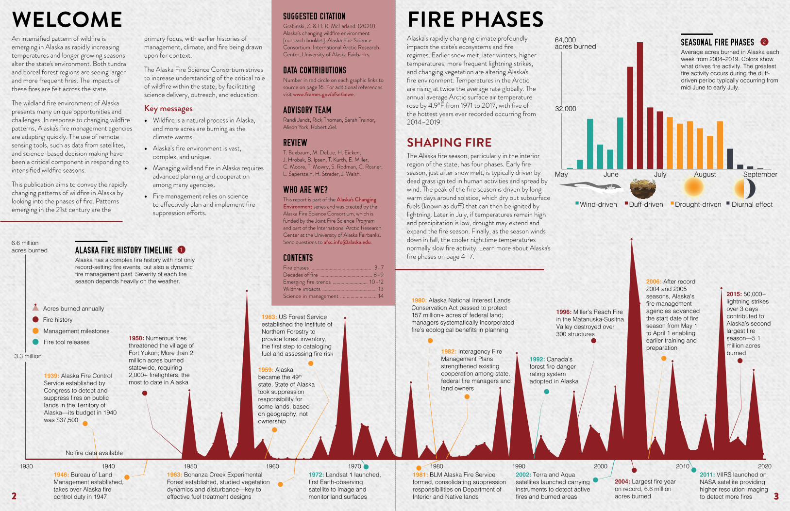
1939: Alaska Fire Control Service established by Congress to detect and suppress fires on public lands in the Territory of Alaska—its budget in 1940 was $37,500
1946: Bureau of Land Management established, takes over Alaska fire control duty in 1947
1963: US Forest Service established the Institute of Northern Forestry to provide forest inventory, the first step to cataloging fuel and assessing fire risk
1963: Bonanza Creek Experimental Forest established, studied vegetation dynamics and disturbance—key to effective fuel treatment designs
1972: Landsat 1 launched, first Earth-observing satellite to image and monitor land surfaces
1980: Alaska National Interest Lands Conservation Act passed to protect 157 million+ acres of federal land; managers systematically incorporated fire’s ecological benefits in planning
2006: After record 2004 and 2005 seasons, Alaska's fire management agencies advanced the start date of fire season from May 1 to April 1 enabling earlier training and preparation
1996: Miller’s Reach Fire in the Matanuska-Susitna Valley destroyed over 300 structures
2002: Terra and Aqua satellites launched carrying instruments to detect active fires and burned areas
2004: Largest fire year on record, 6.6 million acres burned
2011: VIIRS launched on NASA satellite providing higher resolution imaging to detect more fires
No fire data available
1959: Alaska became the 49th state, State of Alaska took suppression responsibility for some lands, based on geography, not ownership
6.6 million acres burned
3.3 million 1992: Canada’s forest fire danger rating system adopted in Alaska
1950: Numerous fires threatened the village of Fort Yukon; More than 2 million acres burned statewide, requiring 2,000+ firefighters, the most to date in Alaska
Fire history
Management milestones
Fire tool releases
Acres burned annually
1982: Interagency Fire Management Plans strengthened existing cooperation among state, federal fire managers and land owners
2015: 50,000+ lightning strikes over 3 days contributed to Alaska’s second largest fire season—5.1 million acres burned
1981: BLM Alaska Fire Service formed, consolidating suppression responsibilities on Department of Interior and Native lands
SUGGESTED CITATION Grabinski, Z. & H. R. McFarland. (2020). Alaska’s changing wildfire environment [outreach booklet]. Alaska Fire Science Consortium, International Arctic Research Center, University of Alaska Fairbanks.
DATA CONTRIBUTIONSNumber in red circle on each graphic links to source on page 16. For additional references visit www.frames.gov/afsc/acwe.
ADVISORY TEAMRandi Jandt, Rick Thoman, Sarah Trainor, Alison York, Robert Ziel.
REVIEWT. Buxbaum, M. DeLue, H. Eicken, J. Hrobak, B. Ipsen, T. Kurth, E. Miller, C. Moore, T. Mowry, S. Rodman, C. Rosner, L. Saperstein, H. Strader, J. Walsh.
WHO ARE WE?This report is part of the Alaska's Changing Environment series and was created by the Alaska Fire Science Consortium, which is funded by the Joint Fire Science Program and part of the International Arctic Research Center at the University of Alaska Fairbanks. Send questions to [email protected].
CONTENTSFire phases ............................................... 3–7Decades of fire ........................................ 8–9Emerging fire trends ........................... 10–12Wildfire impacts .......................................... 13Science in management ............................ 14
An intensified pattern of wildfire is emerging in Alaska as rapidly increasing temperatures and longer growing seasons alter the state's environment. Both tundra and boreal forest regions are seeing larger and more frequent fires. The impacts of these fires are felt across the state.
The wildland fire environment of Alaska presents many unique opportunities and challenges. In response to changing wildfire patterns, Alaska's fire management agencies are adapting quickly. The use of remote sensing tools, such as data from satellites, and science-based decision making have been a critical component in responding to intensified wildfire seasons.
This publication aims to convey the rapidly changing patterns of wildfire in Alaska by looking into the phases of fire. Patterns emerging in the 21st century are the
primary focus, with earlier histories of management, climate, and fire being drawn upon for context.
The Alaska Fire Science Consortium strives to increase understanding of the critical role of wildfire within the state, by facilitating science delivery, outreach, and education.
Key messages • Wildfire is a natural process in Alaska,
and more acres are burning as the climate warms.
• Alaska’s fire environment is vast, complex, and unique.
• Managing wildland fire in Alaska requires advanced planning and cooperation among many agencies.
• Fire management relies on science to effectively plan and implement fire suppression efforts.
WELCOME FIRE PHASESAlaska’s rapidly changing climate profoundly impacts the state's ecosystems and fire regimes. Earlier snow melt, later winters, higher temperatures, more frequent lightning strikes, and changing vegetation are altering Alaska's fire environment. Temperatures in the Arctic are rising at twice the average rate globally. The annual average Arctic surface air temperature rose by 4.9°F from 1971 to 2017, with five of the hottest years ever recorded occurring from 2014–2019.
SHAPING FIRE The Alaska fire season, particularly in the interior region of the state, has four phases. Early fire season, just after snow melt, is typically driven by dead grass ignited in human activities and spread by wind. The peak of the fire season is driven by long warm days around solstice, which dry out subsurface fuels (known as duff) that can then be ignited by lightning. Later in July, if temperatures remain high and precipitation is low, drought may extend and expand the fire season. Finally, as the season winds down in fall, the cooler nighttime temperatures normally slow fire activity. Learn more about Alaska's fire phases on page 4–7.
Duff-driven
September
Diurnal effectDrought-drivenWind-driven
May
64,000acres burned
32,000
JulyJune August
32
ALASKA FIRE HISTORY TIMELINEAlaska has a complex fire history with not only record-setting fire events, but also a dynamic fire management past. Severity of each fire season depends heavily on the weather.
1
SEASONAL FIRE PHASESAverage acres burned in Alaska each week from 2004–2019. Colors show what drives fire activity. The greatest fire activity occurs during the duff-driven period typically occurring from mid-June to early July.
2

54
Duff – decomposing material
Mineral soil
Moss
FIRE PHASES SPRING FIRE • WINDFire season begins in April, typically before full green-up when the below ground soil is still frozen. The most readily available fuels are dead grasses and surface litter. With these limited fuels, wind is the key driver of fire activity. Fire can spread and grow rapidly, but usually with low severity because it cannot burn deeply into the moist and frozen duff.
Early season fire is often the result of human-caused ignitions when outdoor recreation activities and debris burning lead to unintentional fire starts. These preventable fires are usually close to human communities and receive aggressive suppression response.
SHORTER SNOW SEASON Alaska snowpack now develops about a week later in autumn and melts nearly two weeks earlier in the spring compared to the late 1990s. This trend is pushing the fire season earlier and later into the year.
1997
2000
2003
2006
2009
2012
2015
2018
Sep 27 Oct 17 Nov 6 ... May 1 May 21 June 10
Snow season length
Lightning and peak fire seasonLightning is most common during the duff-driven phase. In most years, and all years with a substantial fire season, the majority of acres burned are caused by lightning ignitions. These fires are often in remote locations where managers can allow fires to serve their ecological role without directly impacting human life or property. Human-caused wildfires tend to occur closer to communities, are suppressed quickly, and occur earlier in the year than fires ignited by lightning. In many years, the total number of fires caused by humans is greater, and require more resources to fight than the number of fires started by lightning.
Live shrubs & grasses
MANAGEMENT CORNER
INTERAGENCY FIRE MANAGEMENTAlaska's fire protection strategy is determined by the Alaska Interagency Fire Management Plan. The state is divided into four categories of protection: critical, full, modified, and limited. These management zones are determined by land owner and are re-evaluated annually. Managers prioritize their initial response to new fires based on these zones and the firefighting resources currently available.
Critical protection zones include areas with inhabited property and structural resources. This management zone is the highest priority for allocation of suppression resources. Full protection zones are defined by uninhabited private property, high-valued natural resources, and cultural areas. They receive the second highest priority for fire suppression. Modified protection zones focus on reducing total suppression costs while protecting adjacent resources of higher value. Limited suppression zones cover most of Alaska. Wildfire in these areas usually have ecological benefit, and suppression can be cost prohibitive. Surveillance is used to ensure adjacent areas of higher value are not threatened. If firefighting resources are available, limited protection zones are sometimes allocated with more resources during busy seasons when the risk of spreading to critical and full protection zones is higher.
2001 2005 2010 2015 2019
800 fires
400
6 million acres burned
3 million
2001 2005 2010 2015 2019
Human- caused firesLightning- caused fires
3
LIGHTNING BURNS MORE ACRESLightning burns more acres each year than human-caused fires. Comparing this graph to the graph on the right shows that although humans cause more fires, lightning results in more acres burned.
5
2
MORE FREQUENT LIGHTNINGOn average nearly 60,000 lightning strikes occur in Interior Alaska each summer. Lightning is common from May through August, peaking in June and July. Although lightning data from before 1999 are limited due to sparse sensor coverage, modeling methods reveal long-term lightning trends. Over the past 30 years, June and July lightning activity has increased by about 17%, or 240 strikes per year.
4
100,000 lightning
strikes
40,000 strikes 1980 1990 2000 2010
Photo by NOAA National Severe Storms Laboratory
HUMANS CAUSE MORE FIRESThis graph shows that humans start more wildfires most years than lightning.
5
Parks Highway Fire, June 2006Photo by Adam Kohley
5Photo by Zav Grabinski
FIRE PHASES PEAK SEASON • DUFFIn northern latitudes, a surface layer of slowly decomposing moss, lichen, and litter, called duff, is often about a foot deep. Duff in boreal and tundra landscapes generally accounts for more biomass below ground than available above ground. This duff layer, pictured at right, creates a unique fuel bed where wildfire can burn deep below the surface and smolder for days or weeks, reigniting fuels at the surface when weather conditions become favorable. Fire activity may greatly increase in June as long sunny days quickly dry out duff fuels. Dry duff fuels easily spread fire and can make burns difficult to control. This duff-driven phase of the fire season is typically when peak fire activity occurs.
Trend
First snow Last
snow

76
+6.2°F
+4.6°F
+4.6°F
+4.8°F
+4.1°F
+3.7°F+3.6°F
+3.2°F+3.3°F +2.5°F
+2.8°F
+2.5°F+2.5°F
SUMMER'S GETTING HOTTERSummer temperatures across Alaska have been increasing since 1970 (see map at right). A typical summer nowadays is close to what the warmest summers were prior to the 1970s. When comparing the average June to August temperatures over the last 95 years, nine of the ten warmest summers occurred in the past twenty years, whereas the ten coldest summers all occurred before 1975.
VARIABLE PRECIPITATIONAlthough precipitation is much more variable than temperature, annual precipitation has increased in all regions of the state since 1970 (see map at right). Recent summers have been particularly wet in Interior Alaska as shown in the graph below. Nine out of Alaska's ten driest summers all occurred before 1980. Research indicates, however, that precipitation would have to increase by about 7-10% per degree of temperature increase to offset the increased fire danger due to warming temperatures.
FIRE PHASES FALL • DIURNALFire season in Alaska is typically pushed to a close by shorter days with lower solar radiation. As nighttime temperatures drop and relative humidity increases, fire has difficulty spreading. The past two decades, however, have included notable late-season fire events related to relatively high temperatures and low precipitation in August.
1925 1935 1945 1955 1965 1975 1985 1995 2005 2020
56°F average summer temperature
52°F
48°F
Ten warmest summersTen coldest summers
LONGER FIRE SEASONAlaska's wildfire season is getting longer. Over the past 40 years, the first large fire (1000+ acres) of the season starts earlier, and the last large fire of the season starts later. Fire managers responded by changing the official start date of the fire season. Since 2006, Alaska's official fire season has started on April 1. This reduces accidental ignitions by requiring permits in order to burn debris and allows agencies to begin training personnel and allocating resources earlier. In busy fire seasons, such as 2019, the fire season may be extended into the fall.
WARMER NIGHTSDaily low temperatures are increasing. Alaska now experiences many more warm nights compared to the early part of the 20th century. This is especially true for Interior communities like Fairbanks. The five summers with the warmest nights (the red dots on the graph) all occurred in the past twenty years, whereas the five summers with the coldest nights (blue dots) occurred before 1950. Warming nighttime temperatures are especially impactful in Alaska, where the long daylengths of midsummer can allow fires to burn around the clock.
3 AGENCIES, 375 MILLION ACRESThree wildland fire protection agencies are responsible for fire suppression across the entire 375 million acres of Alaska. The Bureau of Land Management (BLM) Alaska Fire Service, the Alaska Division of Forestry, and the US Forest Service have primary authority to organize fire suppression operations within their respective regions. The protecting agencies work together under the Alaska Master Cooperative Wildland Fire Management and Stafford Act Agreement to coordinate wildland fire management efforts efficiently.
Bureau of Land Management, Alaska Fire Service, 192 million acres. Alaska Division of Forestry, 154 million acres. US Forest Service, 28 million acres.
MANAGEMENT CORNER
6
McKinley Fire in August, 2019Photo by Kale Casey
6
6
2
6
2
90 days with nighttime temperature above 50°
in Fairbanks
45 days
1930 1940 1950 1960 1970 1980 1990 2000 2010 2020
Five warmest summersFive coldest summers
Increase in warm summer
nights
+12%
+10%
+19%
+19%
+14%
+3%+10%
+8%+17%
+14%+10%
+4%+11%
40% more precipitation than normal in Interior Alaska
normal
40% less precipitation than normal
1940 1950 1960 1970 1980 1990 2000 2010 2020 1925Nenana Ridge Fire July, 2009Photo by Scott Rupp
Annual precipitationtrend, 1970–2019
Annual temperature trend, 1970–2019
FIRE PHASES LATE SUMMER • DROUGHTAs lightning diminishes toward the end of July, fewer fires are ignited. Existing fires may grow during the drought-driven stage of the fire season if late summer rains are sparse. Fires during extreme drought can be difficult to extinguish and may even result in fires burning underground through winter.
1980
1990
2000
2010
2020April 20 May 30 July 19 September 7
Fire season length
Start of first large
firefire
Start of last large fire
Trend

98
TAYLOR COMPLEX FIRE • largest Alaska fireThe Taylor Complex Fire consumed approximately 1,305,592 acres in 2004. By acreage, it was the largest wildfire in the United States between 1997–2007. It was also part of the record-breaking 2004 Alaska fire season that burned more than 6,590,140 acres.
ANAKTUVUK RIVER FIRE • largest Alaska tundra fireDuring the hot and dry summer of 2007, the Anaktuvuk River Fire doubled the total burned area of Alaska's North Slope since 1968 and initiated widespread permafrost degradation. The fire burned for nearly three months, gaining most of its acreage in September, ultimately consuming more than 250,000 acres. Although limited in the past, tundra fire frequency seems to be increasing, especially in southwest Alaska.
2
1
2
FUEL BREAKS • successful management strategyFuel breaks play a critical role in reducing fire risk. One study found that every dollar spent on fuel breaks equates to $165 saved in protected structures. Along the Kenai National Wildlife Refuge, breaks have helped firefighters protect nearby communities from multiple fires in recent years.
4
SWAN LAKE FIRE • Alaska's most expensive fireThe Swan Lake Fire burned the coastal boreal forest of Kenai Peninsula. Hot, dry conditions and unusual lightning in 2019 sparked the 167,164 acre fire. Bordering several communities, fire suppression cost an estimated $49 million. Having burned extremely deep, two fires smoldered underground through winter, reigniting in 2020.
3
1961-1980 FIRE PERIMETERS Looking back 40 to 60 years, wildfires burned about one third (11.8 million acres) of the area they consumed in the current 20-year period.
1981-2000 FIRE PERIMETERS Wildfires burned 14.1 million acres during the 1981–2000 time period.
INTERIOR BOREAL FORESTThe majority of fire activity in Alaska occurs in the boreal forest between the Alaska and Brooks mountain ranges.
1
3
4
DECADES OF FIREWhile fires are natural in Alaska, the frequency of million-acre fire seasons over the past few decades is unprecedented (see the graph on page 10). Few places in Interior Alaska are untouched by wildfire, as demonstrated by this fire perimeter map showing wildfires that burned over the past 20 years. From increasing fire activity on treeless tundra, to hot and dry conditions sparking fires in coastal boreal forest, it is clear that wildfire in Alaska is changing.
9
Photo by USGS
Photo by Alaska Division of Forestry
Photo by Alaska Fire Information
1
Brooks Range
Alas
ka Range
2001-2020 FIRE PERIMETERS From 2001–2020, wildfire in Alaska burned 31.4 million acres. Over 2.5 times more acres burned than during the previous two decades.
Photo by USFWS

1110
EMERGING FIRE TRENDSDespite variability from season to season, evidence suggests that wildfire is burning more acres and expanding into new areas of the state. The increasing area burned, along with fires that are more frequent, survive over winter, or reburn the same location after just a few years are consistent with the predicted effects of climate change. This has statewide implications including increased fire risk for people, property, and resources.
Carbon storageFrozen permafrost holds an estimated 1,400 gigatons of carbon. This amount of carbon is greater than what is already in the atmosphere today. Wildfires release this stored carbon to the atmosphere by removing the duff and soil layers that insulate permafrost, accelerating its thaw. Thawed permafrost can cause surface water to drain, resulting in drier and more flammable duff. As permafrost thaws, it releases more methane and carbon dioxide into the atmosphere, setting up an amplifying feedback to climate warming.
Holdover firesFires can smolder in Alaska's below-ground duff fuels without visible flames; some of these "holdover" fires can even linger through the winter and present a risk of flaring up the following spring. Although holdover fires have been documented in Alaska for decades, agency personnel suspect they are increasing in frequency. Since 2005, more than 40 overwintering fires have been reported in Alaska, many following a big fire season.
7 million acres burned annually
3.5 million
1950 1960 1970 1980 1990 2000 2010 2020
1.9%
1991–2000
3.1%
2011–2020
5.2%
2001–2010
1.5%
1971–1980
1.6%
1961–1970
1.8%
1981–1990
KEY TO STATEWIDE COORDINATIONAlaska employs an interagency management strategy to coordinate statewide wildfire response. The Alaska Wildland Fire Coordinating Group (AWFCG) and the Alaska Interagency Coordination Center (AICC) work with land owners and wildland fire protection agencies to facilitate planning and implementation of wildfire response.
The AWFCG oversees planning and implementation for interagency fire management statewide. AWFCG organizes interagency committees with specific responsibilities such as fire modeling and analysis, air quality and smoke management, fire education and prevention, and geographic information systems. AWFCG includes representatives from agencies including the Alaska Department of Fish and Game, Alaska Department of Natural Resources, Association of Village Council Presidents, Bureau of Indian Affairs, Bureau of Land Management, Chugachmiut, Tanana Chiefs Conference, US Fish and Wildlife Service, US Forest Service, and National Park Service.
The AICC is Alaska’s geographic area coordination center. AICC acts as the central coordination point for all state and federal wildland fire management and suppression agencies by providing initial attack resource coordination, logistical support, and predictive services.
MANAGEMENT CORNERTundra firesIn northern and western Alaska, warm and dry conditions have contributed to an increase in wildfire frequency in different parts of tundra ecosystems. By 2100, the Alaskan tundra may experience twice as much total burned area and up to four times more frequent burns compared to historical records. Wildfire can radically alter the composition of slow-growing tundra vegetation. Liverworts, sedges, and dwarf shrubs appear to readily regrow, while lichen and sphagnum moss are often reduced or nearly absent for decades. An expanding tundra fire footprint may limit foraging area for caribou, who depend on lichen for about half of their fall and winter diets.
Photo by Mike McMillian
Photo by Alaska Division of Forestry
INCREASED ACRES BURNED Area burned by wildfire varies tremendously from year to year. Factors such as temperature, drought, and earlier snow melt contribute to this variation. The past 20 years have experienced a clear shift toward more frequent large fire seasons with millions of acres burned, although years with relatively few burned acres are still common.
7
HOW MUCH OF ALASKA BURNS?The red circles show the proportion of Alaska, relative to the size of the state, that burned each decade. 2001–2010 marked the largest decade of fire on record with nearly 20 million acres burned, amounting to over 5% of the total area of Alaska burned in a ten-year period.
2
Million + acres burnedFewer than 1 million acres burned
More green
Less green 1981 1990 2000 2010 2020
TUNDRA GREENING AND WILDFIRESince 1981, North Slope tundra has significantly greened, although there was a slight decline on the eastern North Slope over the past five years. Satellite data estimate greenness by measuring the light reflected by plants. In the tundra, high measures of greening are associated with increased aboveground vegetation and potentially more fuel available for wildfires.
8
Bark beetleSouthcentral Alaska is currently the epicenter of a decades-long spruce beetle outbreak. Forest health surveys mapped 139,500 acres of dead or dying spruce in 2019, down considerably from 593,000 acres in 2018, and 405,000 in 2017. This decrease in acreage is likely due to fewer live trees remaining. The outbreak is still ongoing and expanding in nearly all directions from previously affected forests. Spruce beetles are native to Alaska. When in low numbers they prefer old, slow-growing or injured trees, but during outbreaks they will infest trees as small as 6 inches in diameter. Surprisingly, dead spruce are not more flammable (at least not after they drop their needles) than live spruce, but the accumulation of dead trees and limbs on the ground can result in large woody fuel loads. As trees died from a beetle outbreak on the Kenai Peninsula, grasses expanded into formerly forested areas, forming dense mats of dry grass which can rapidly carry surface fires.
Hemlock Sawfly 381,034 acresBirch defoliation* 283,414 acresSpruce beetle 139,502 acresAspen defoliation* 132,447 acresWillow defoliation* 32,656 acresYellow-Cedar decline 19,995 acres
*Defoliation indicates damage to leaves/needles
FOREST PESTS/DISEASEIn 2019, the US Forest Service surveyed 24.4 million acres of Alaska's forests, finding over 1.1 million acres of damage from insects (including spruce beetle), diseases, declines, and other factors. Note: This map shows only survey sections with forest damage visible from a plane. Activity is enhanced with a large border to aid visualization.
9

1312
20% of region burned per time
interval
10% burned
1943–19681969–19841985–20002000–2016
More frequent fire Less frequent fire Mixed or neutral trend Insufficient data to identify a trend
Region of Alaska indicatedin data above
Reburns and fire return intervalA reburn occurs when fire impacts the exact same spot burned previously. Fire return interval is the time between fires that occur within a relatively small geographic area. Reburn fires in Alaska are happening more frequently, possibly indicating a shift to a shorter fire return interval. Land managers are concerned about this trend. Fire suppression personnel may no longer be able to rely on recently burned areas as effective barriers to new fire growth, as they have in the past. The recovery and transition of vegetation, and the resulting fuels, in areas that have burned multiple times is complex and poorly understood.
VILLAGE-BASED FIREFIGHTERSAlaska has long relied on seasonal wildland firefighters from rural communities. During the 2020 fire season, BLM Alaska Fire Service awarded three contracts for Type 2 wildland firefighting hand crews based in rural Alaska villages. Contracted crews offer new opportunities and more stable employment for village-based crews since they are able to work outside of fire suppression, such as on fuels reduction and other funded projects. When fire activity in the Lower 48 exploded, the crews were assigned to northern California. The crews included:• Upper Yukon Region: Council of Athabascan Tribal Governments
with firefighters mobilizing in Fort Yukon, Venetie, and Arctic Village• Lower Tanana Region: firefighters mobilizing in Minto and Tanana• Upper Koyukuk Region: firefighters mobilizing in Huslia, Hughes,
and AllakaketVillage-based federal and state emergency firefighter crews were also hired on an as-needed basis in 2020. Crews hailed from Hooper Bay, Scammon Bay, Chevak, Kalskag, Tetlin, Tanacross, Tok, Northway, and Mentasta Lake.
MANAGEMENT CORNER
FIRE IMPACTSThe impacts of wildfire on people and wildlife are complex. Some effects such as infrastructure damages, loss of life and injury, fire suppression cost, and health problems related to smoke are trackable. Other effects such as habitat change, impacts to hunting and fishing, and public anxiety are more difficult to document. Alaskans are particularly vulnerable, with an estimated 80% of the population living in areas at risk of wildfire.
Wildfires near communitiesWith the second hottest June ever recorded in Alaska, and extremely low precipitation in July, 2019 proved to be a landmark year for close-to-home fires. Wildfires that posed threats to communities included the Chalkyitsik Complex, Grouse Creek, Kobe, Malaspina, Montana Creek, McKinley, Shovel Creek, and Swan Lake fires. Estimated suppression costs during the 2019 wildfire season were at least $300 million.The McKinley Fire which started in late August 2019 destroyed 50 homes, 3 businesses, 84 outbuildings, and a major power transmission line which cost $10.4 million to replace (nearly six times more than the average maintenance costs for 2000–2019). While there were no buildings destroyed or loss of life during the Swan Lake Fire, fire suppression was a monumental effort that lasted nearly 150 days. Suppression costs were estimated at $49 million requiring over 3,000 personnel.
Fish and wildlifeMany wildlife species depend on wildfire to maintain habitat diversity. Impacts to fish and wildlife depend on the species, time of year, location, vegetation burned, and the severity and extent of the fire. In summer, moose can benefit from the shade and predator protection of birch and aspen that grow after high-severity fire, and in winter highly-desirable willow is often available for foraging after low-severity fire. While wintering caribou avoid burns over lichen, burns along migration routes can sometimes benefit caribou. Wildfires that reduce shade over rivers can cause water temperatures to rise which can impact fish, aquatic plants and insects. These are just a few examples of the complex relationships between fire and wildlife.
BURNING AGAIN Since 1980, over 1500 fires burned in areas that had already burned during the previous 20 years. The acres reburned annually by these 'reburn fires' significantly increased in the early 2000s, as illustrated in this graph. The reburn locations, since 1980, are shown in the map at right.
Council of Athabascan Tribal Governments crew in CaliforniaPhoto by BLM Alaska Fire Service
More smokeAs the frequency of big (1+ million acres) wildfire seasons has increased, so has the number of smoky days, posing a significant health hazard. During active wildfire seasons, smoke particulates are the dominant source of airborne particles in Interior Alaska. Beyond public health, smoke can limit visibility to the point where air travel is not possible, disproportionately affecting rural areas serviced only by plane.Wildfire smoke is particularly hazardous because it contains particles small enough (less than 2.5 microns in size) to travel deep into the lungs and bloodstream. This can cause serious lung and heart problems. Children, elderly, and those with existing lung or heart conditions are at the greatest risk. Wildland firefighters also face significant exposure to smoke, and the long-term health effects are largely unknown.The Alaska Department of Environmental Conservation helps manage smoke-related health risks by providing near real-time air quality advisories, regional air quality forecasts, and recommendations for safety precautions and activity levels.
2
SMOKY DAYS Prior to 2004, Fairbanks had only one summer (1957) in the previous half century with more than three weeks of significant smoke. Since 2004, prolonged smoke episodes have occurred five times, including twice since 2014. Smoke is a less frequent problem in Anchorage, but 2019 was by far the smokiest summer. Smoky days are based on the airport's reported visibility of six miles or less in smoke.
6
1952 1970 1990 2010
40 smoky days in Fairbanks
20
FIRE RETURN INTERVALOne way to approximate the fire return interval is to compare how the percentage of a region burned changes over time, as shown in this graphic. This graphic shows that the fire return interval varies regionally in Alaska. Wildfire is occurring more frequently in recent decades in the central and eastern Interior, as well as parts of western Alaska where fire has been less common. On the Seward Peninsula, the fire return interval is decreasing.
10
Parks Highway Fire in 2006Photo by Tom Kurth
2020
40 smoky days in Anchorage
20
1960 1970 1990 201020001980
40,000 acres reburned
20,000
1990 2000 2010 20201980

1514FIRE WEATHER INDEX BUILDUP
INDEX
FUEL MOISTURE
FINE FUELSMOISTURE
grass, low shrubs, moss & litter
DUFFMOISTUREdecomposing
organicmaterial
DROUGHT
FIRE WEATHER
temperaturerain
INITIAL SPREAD INDEX
wind
temperature, relative humidity,
rain
temperature, relative humidity,
wind, rain
SOIL
PERMAFROST
DUFF
FIRE DANGERAlaskans are likely familiar with the fire danger signs seen along roads, warning of the current level of fire risk. Those rankings come from the Fire Weather Index System. The index is used in Alaska and Canada and merges two other indices. The Initial Spread Index takes into account the wind speed and the moisture of fine surface fuels like grass, moss and shrubs. The Buildup Index is a measure of available fuel on the landscape, incorporating the moisture of duff and seasonal drought.
12
SCIENCE IN MANAGEMENTAlaska's wildfire environment is unlike any other. Boasting the largest state, the lowest population density, the most public land, and complete isolation from the continental United States, Alaska needs specific fire management tools to meet its unique needs. Alaska's fire managers partner with scientists to improve the scientific basis for management responses to changes in fire and climate conditions, including developing applications of remotely sensed data, evaluating the effectiveness of fuel treatments, and obtaining the most accurate geospatial data for decision support.
Joint Fire Science ProgramThe Joint Fire Science Program (JFSP) is a federal program that funds research and delivery of fire science to meet emerging needs of land managers and policymakers at local to national levels. The Alaska Fire Science Consortium (AFSC)is one of 15 Fire Science Exchanges funded by JFSP. The consortium brings together managers, practitioners, and researchers to address fire management needs and challenges. Events such as AFSC's Spring and Fall Fire Science Workshops help researchers better understand the evolving science needs of fire managers and informs fire managers of new research results that can help with decision making.
University of AlaskaStudents and researchers at the University of Alaska have focused on wildland fire science topics for decades. At the University of Alaska Fairbanks (UAF) campus, the Long Term Ecological Research program has been studying the boreal forest since 1987, including tracking the lasting impacts of fires like the 1983 Rosie Creek Fire. The International Arctic Research Center is another UAF hotspot for fire science and related climate research. Within the center, the Alaska Fire Science Consortium and other groups work with Alaska's land managers to develop climate and fire science products to meet their unique needs. The recently formed EPSCoR Boreal Fires Team draws on expertise at UAF and the University of Alaska Anchorage to develop ground-breaking research advancing fire detection algorithms, seasonal predictions of fire danger, precise classifications of vegetation, and information on the economic and social impacts of wildland fire in Alaska.
WILDFIRE & SATELLITESSatellite technology has transformed fire management in Alaska. Fire managers routinely use information provided by the Visible Infrared Imaging Radiometer Suite (VIIRS) system and other satellites for fire detection, monitoring, and mapping. Refined fire detection algorithms used with VIIRS are paving the way for advanced fire activity modeling and prediction, rapidly emerging as a key management resource. This type of remote sensing is especially important in Alaska where most of the state is inaccessible by road and fire suppression resources are scarce compared to the state's size. Not only can fires be detected, mapped, and monitored remotely, but factors associated with fire, such as soil moisture and vegetation composition, can be studied across the entire state. In addition to satellite information, fire managers and scientists use data and imagery from sensors on unoccupied aerial vehicles (drones) and planes.
FUEL BREAKS One of the best ways to protect Alaska communities from wildfire is by creating fuel breaks between populated areas and wild lands. Shaded fuel breaks in boreal black spruce forests may reduce fire potential for over 14 years by reducing canopy density and
ladder fuels. When these fuel treatments are present on public lands, nearby homeowners are more willing to spend time and money on improving their own defensible spaces. Prescribed fires, a form of fuel break, are an important wildfire management strategy. Carefully planned burns can help expand the space between communities and Alaska’s expansive and flammable forests.Evidence from a cooperative project led by UAF shows that fuel breaks can provide an incredibly cost-effective tool for fire suppression. For example, when fuel breaks were tested by the Funny River (2014), Card Street (2015), and Nenana Ridge (2015) fires, treated areas had less intense surface fires. Fuel breaks also expand the tactical options that managers can use on fires near communities, as was shown by the 2010 Eagle Trail and 2019 Shovel Creek and Swan Lake fires.A new online database tracking fuel breaks was released in fall 2020. This comprehensive database shows where fuel breaks are in the context of management zones and other geographic information. The resource provides a valuable tool in decision making and planning.
ASSESSING FIRE DANGERReliable real-time weather data and accurate forecasting is essential to assessing risk of wildfire. The Fire Weather Index System is used to create daily fire danger ratings across Alaska. The system, which is part of the Canadian Forest Fire Danger System, estimates the moisture content in fine dead fuels and duff based on temperature, rain, relative humidity, and wind speed.
VIIRS is polar orbiting and provides ~4-5 high quality images per pay
Landsat 8 passes Alaska less than once per week
MONITORING WILDFIREVIIRS sensors are used for detecting and monitoring Alaska wildfires because they provide sufficient frequency and detail to support initial detection, daily decision-making, and incident mapping when other higher resolution products are not available.
Area burned
11
FIRE DANGER
PREVENT FOREST FIRES
LOW
M
ODERATE HIGH VERY HIGH EXTREME
Randi Jandt, 2019 Fall Fire Review
AGENCY MESSAGES• Public and firefighter safety is the first
priority.• Wildland fire happens, be ready.• Wildland fire is an essential, natural process.• Alaskans work together to manage
wildland fire.• Managing wildland fire in Alaska balances
risks and benefits in an ever-changing environment.
• Prevention is key to reducing human-caused wildfires.
MANAGEMENT CORNER

16
GRAPHICS AND DATA SOURCES1 • Zav Grabinski, Alaska Fire Science Consortium & Heather McFarland, International Arctic Research Center (data source Alaska Interagency Coordination Center)2 • Zav Grabinski, AFSC (data source AICC)3 • Brian Brettschneider, IARC/National Weather Service (data source National Snow and Ice Data Center)4 • Peter Bieniek, IARC (data source ERA-Interim reanalysis)5 • Zav Grabinski, AFSC (data source National Interagency Fire Center)6 • Rick Thoman, Alaska Center for Climate Assessment and Policy (data source NOAA/NCEI & NWS)7 • Rick Thoman, ACCAP (data source AICC)8 • Uma Bhatt, Geophysical Institute (data source NASA/GSFC)9 • Forest Health Conditions in Alaska, US Forest Service Alaska Region, State & Private Forestry10 • Tom Paragi, Alaska Department of Fish and Game & Heather McFarland, IARC (data source AICC)11 • Jennifer Jenkins, Alaska Fire Service (data source Geographic Information Network of Alaska)12 • Heather McFarland, IARC
For text references and a glossary of terms visit www.frames.gov/afsc/acwe.
HOMEOWNERS TAKING ACTIONAlaska has a higher percentage of homes within the wildland fire interface than any other state. It is important that homeowners recognize the risk of wildfire and take action to protect themselves and their communities. Initiatives such as Firewise, Community Wildfire Protection Plans, and Ready, Set, Go help provide knowledge and resources so that individuals can collaborate to prepare for and respond to fires effectively as part of a fire adapted community.
ALASKA FIREWISEFirewise is a collaboration between local, state, federal, and private agencies and organizations to promote wildland fire safety. This cooperative effort aims to help communities at risk by providing residents with the knowledge and skills needed to achieve a high level of protection from wildfire. Community efforts such as Firewise Task Forces and multi-disciplinary Firewise Boards rely on individuals collaborating with fire professionals, public land managers, and others to prepare for wildfires by assessing readiness for a community to withstand a wildfire, sponsoring fire risk reduction events, and developing Community Wildfire Protection Plans. When communities follow Firewise activities individual homeowners benefit through saved lives and property.
COMMUNITY PROTECTION PLANSCommunity Wildfire Protection Plans (CWPP) describe wildfire hazard and mitigation strategies including prioritized fuel reduction strategies and recommendations for homeowners to reduce risk of structural damage from fire. Collaboration is key to implementing successful CWPPs, and broad participation involving individuals, local and state governments, public land managers, fire management agencies, and community groups is the best way to develop effective plans. Local plans and ways to be involved can be viewed on the Alaska Department of Natural Resources, Division of Forestry website.
Read it online at www.frames.gov/afsc/acwe
Nenana Ridge Experimental Burn July, 2009Photo by Scott Rupp