Embed Size (px)
Citation preview

Enterprise GIS for Facilities Management Integrating and Managing FM Data

Overview
• GIS and FM• Demonstration - FMV• Data Management
- Data planning- Data collection
- Demonstration #2- Data maintenance
- Demonstration #3
• Data Integration• Summary

GIS and FM

SiteGeography
SiteGeography
UrbanGeography
UrbanGeography
RegionalGeographyRegional
Geography
BuildingGeography
BuildingGeography
GIS Is Evolving
. . . Integrating Building Information. . . Providing New Capabilities for Design and Management Community

How can GIS be used in Facilities Management?
• Real estate and portfolio management
• Facility and space management
• Maintenance management• Environmental and
sustainability management • Emergency preparedness• Visualization

Managing, Analyzing & Visualizing Building Data at All Scales
Country
Region
City
Building
Global
CampusRooms
EquipmentFurniture
GIS "is the only technology that has the ability to scale across any expanse, from the individual asset within a building to a virtually global context"

PerformanceManagementDashboards
CommonOperating
Picture
Planning SiteSelection
Permitting
CodeEnforcement
Construction SiteManagement
Real EstatePortfolio
Management
FacilityManagement
SpaceManagement
AssetManagement
EnvironmentalHealth & Safety
Management
EmergencyPlanning and
Response
Continuity ofOperations
SecurityManagement
EnergyManagement
MaintenanceManagement
IWMSCAFM
ERP
GIS
EAM
Supporting the Real Property LifeSupporting the Real Property Life--CycleCycleGIS Integrates the Facility Management EnterpriseGIS Integrates the Facility Management Enterprise

What is a GIS for Facilities Management?
• An enterprise system• Requires multiple data models• Addresses specific problems and
specialized needs• Integrates with multiple systems• Offers portable data• Provides specialized analysis
- Interior space- Ingress/egress- Efficiency- Proximity to other facilities

Facilities Management Viewer

Data Management

Data Management
• Data Planning- What, when, who, and how
• Data Collection- Quality, cost, and schedule
• Data Maintenance - Process, tool, quality, and time
• Data Analysis- Business needs, creative solutions, and fun

Data Planning
• Development area• Source data• Data model• Data accuracy• Data development plan
- Process- Resource- Schedule

Data Planning
• Choose Functional Solution Areas- Master Planning- Real Estate Portfolio Mgmt- Maintenance Mgmt- Space Mgmt- Work Order/Project Mgmt- Asset Mgmt- Energy/Sustainability- Safety & Security
• Information often crosses functional areas
Data Planning
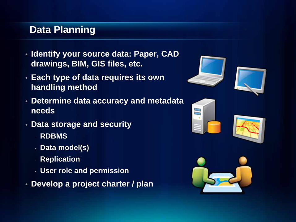
• Identify your source data: Paper, CAD drawings, BIM, GIS files, etc.
• Each type of data requires its own handling method
• Determine data accuracy and metadata needs
• Data storage and security- RDBMS- Data model(s)- Replication - User role and permission
• Develop a project charter / plan

Source Data
• Facilities with no data- Field data collection- Locate as-built drawings- Photographs- Automated collection (robots)
• All collection approaches are valid
• Paper drawings- Scan and batch vectorizing- Consider drafting individual layers- Manually digitize
• Spatial reference must be considered

Source Data
• Non-standard CAD drawings- Identify layers- Consider ETL tools- Can be very complex
• If CAD files provided by contractor, consider mandate for standardized data
• Standardized CAD drawings- Map layers to GIS- One ETL to import all
• Consider benefits of importing vs. managing in CAD

Source Data
• Existing GIS data- General best case scenario- Security and access is easier to
manage• Remember that not all functional
areas are GIS-aware

Source Data
• BIM files- Consider the exchange format- Custom ETLs required to import
to GIS• Data loss is a great concern when
going from BIM to GIS

Source Data
• Data stored in external systems- Interoperability issues- Data synchronization problems- Incompatible analysis models
• Consider whether to migrate or interoperate

Data Model
• Data model design- Consider your target location- Database schema must support
business rules- Support source data - Support application logic- Support data maintenance process- Support system integration
• Leverage existing models- BISDM- Utilities- Parcels- Land management

GeoDatabase Data ModelsStandardized Templates for Many Fields
•• AddressAddress•• AgriculturalAgricultural•• AtmosphericAtmospheric•• Base MapBase Map•• BiodiversityBiodiversity•• CensusCensus--AdminAdmin•• BoundariesBoundaries•• DefenseDefense--IntelIntel•• Energy UtilitiesEnergy Utilities•• Environmental Environmental •• ForestryForestry•• GeologyGeology•• GroundwaterGroundwater•• HealthHealth
•• Historic Preservation Historic Preservation & Archaeology& Archaeology
•• Homeland SecurityHomeland Security•• HydroHydro•• IHOIHO•• Land ParcelsLand Parcels•• Local GovernmentLocal Government•• MarineMarine•• National CadastreNational Cadastre•• PetroleumPetroleum•• PipelinePipeline•• TelecommunicationsTelecommunications•• TransportationTransportation•• Water UtilitiesWater Utilities• Building Interior Space
Simple feature classHaul Contains Z values
Contains M valuesGeometry Point
NoNo
Data typeField namePrec-ision Scale LengthDomainDefault value
Allownulls
OBJECTID Object IDSHAPE Geometry Yes
HAULJOIN Long integer No 0VESSELCODE Long integer No 0
CRUISE Long integer No 0HAUL Long integer No 0
STATION_ID String No 7SSTEMP Float No 0 0
BOTTOMTEMP Float No 0 0EFFORT Float No 0 0
DataSourceID String Yes 50
TableDataSource
Data typeField namePrec-ision Scale LengthDomainDefault value
Allownulls
OBJECTID Object IDDESC_ String Yes 35
SOURCE String Yes 35CONTACT String Yes 20
PREC String Yes 20CREATE_DATE Long integer Yes 0
LAST_UPDATED Long integer Yes 0DataSourceID String Yes 50
TableFishCatch
Data typeField namePrec-ision Scale LengthDomainDefault value
Allownulls
OBJECTID Object IDHAULJOIN Long integer No 0
SPECIESCODE Long integer No 0LATINNAME String No 28
COMMONNAME String No 21WEIGHTCPUE Double No 0 0NUMBERCPUE Double No 0 0
Relationship class
NamePrimary keyForeign key
TypeCardinalityNotification
Forward labelBackward label
No relationship rules defined.
DataSourceHasHaul
Origin table Destination feature class
SimpleOne to manyNone
HaulDataSource
DataSourceDataSourceIDDataSourceID
HaulName
Relationship class
NamePrimary keyForeign key
TypeCardinalityNotification
Forward labelBackward label
No relationship rules defined.
HaulHasFishCatch
Origin feature class Destination table
SimpleOne to manyNone
FishCatchHaul
HaulHAULJOINHAULJOIN
FishCatchName
www.esri.com/fm

Geodatabase Entities
• Object Classes- Collection of attribute rows and columns
• Feature Classes- Collection of spatial features
• Feature Dataset- Collection of like feature classes
• Topology • Relationship Classes• Raster Dataset • Annotation
- Feature Linked and Stand-Alone

Data Collection
• Multiple data capture methods- Field collect- Digitize- Scan- Extract, Transform, Load (ETL)- Integrate
• Do what makes most sense- Field collect when nothing exists- Scan/digitize when GIS is primary target- Integrate when managed externally
• Control quality - “Garbage in, garbage out”• Most time consuming and costly - set expectation!

Data Interoperability Demo

Data Maintenance
• Design a workflow- Centralized vs. decentralized
approach• Quality control
- Shift focus to error prevention rather than error correction
• Establish a reasonable turn around time
• Adopt COTS tools to help- Data Interoperability Extension- Workflow Manager (WMX)- Production Mapping Extension

Data Maintenance
• Considerations in editing facility data in GIS- GIS vs. CAD- Data integrity- Data exchange- What about 3D?

Data Editing
• GIS vs. CAD- Sometimes easier to edit in CAD- ArcGIS for AutoCAD- Maintain in CAD- Analyze in ArcGIS
• Think about where the data normally lives
• Utilize COTS tools to prevent error

ArcGIS for AutoCAD
• Maintain data in native format• Map attributes to GIS schema• Perform GIS analysis in
AutoCAD

Construction Management System Demo

Data Editing
• Data integrity- Redundancy causes synch problems- Topology rules only work in GIS- Consider who is editing the data- Consider replication vs. export
• Data integrity is the responsibility of the most critical stakeholder

Data Editing
• Data exchange- Multiple exchange formats can
be problematic- Integration with external
systems requires management
• It is a general best practice to maintain data in its native system and leverage it in GIS
• You must decide which system is native

Data Editing
• What about 3D?- Do you really need to store your data
in 3D? Why?- Extruded 2D is sufficient for most
analysis- 3D editing tools are limited- 3D editing is difficult and time
consuming
• Consider your 3D requirements- Is the exact height of a plug or switch
needed?- Do you need to show windows, doors
and other fixtures realistically?- Are you performing analysis based
on real 3D?
Data Analysis
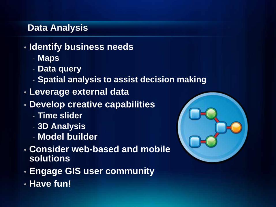
• Identify business needs- Maps- Data query- Spatial analysis to assist decision making
• Leverage external data• Develop creative capabilities
- Time slider- 3D Analysis- Model builder
• Consider web-based and mobile solutions
• Engage GIS user community• Have fun!

GIS Enables Integrated Data Management
Thinning
SpatialETL
SpatialETL
GISGISIFCIFC
CADCAD
Building Models
City GMLCity GML
BIMBIM
Visualization(Sketch Up) Visualization(Sketch Up)
Any Client
Open API
Open API
…….Supporting Many Applications

Data Integration
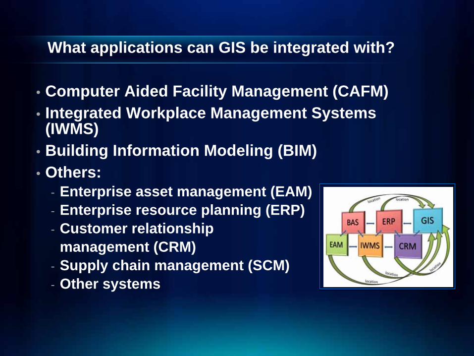
What applications can GIS be integrated with?
• Computer Aided Facility Management (CAFM) • Integrated Workplace Management Systems
(IWMS) • Building Information Modeling (BIM)• Others:
- Enterprise asset management (EAM)- Enterprise resource planning (ERP)- Customer relationship
management (CRM)- Supply chain management (SCM)- Other systems

Building Information Is Becoming Part Of GISIntegrating Building Data with Other Geographic Information
. . . Leveraging The Power Of GIS In Building and Management
BrowserMobile
Desktop
Interoperability• Web Server
• ETL• IFC
GIS Server
CAD
BIM
3-D Tools
Geodatabase
Tools• 3-D Data Model
• Editing• Visualization
• Design• Analysis

How can GIS be integrated with other FM systems?
• Approach 1: Open application programming interface (API)
• Approach 2: The “map it” approach• Approach 3: Fully integrated GIS and external
systems
GDBGDBShare PointShare Point
RESTRESTFlexFlex
SilverlightSilverlight
Open API’sSOAPSOAP
WCSWCSISOISO
KMLKML WFSWFS
CADCAD
WWWWWW
SQLSQL
INSPIREINSPIRE
Standard s
OGCOGC
JavaJavaWMSWMS
Open Data Access

Data Integration
• Few considerations- External system requirements- Formats- Access- Synchronization- Transformation and potential data
loss when exporting data

Summary

Summary
• Data Planning- Consider your source and your target- Develop a database schema that addresses your
business rules• Data Collection
- Leverage existing data- Determine reasonable data accuracy- Set expectation - most time consuming and costly
task• Data Maintenance
- Maintain data where it makes the most sense- Leverage GIS where GIS power is crucial- Maintain non-spatial data in its native system
Summary
• Data Management- Think about how your users need to access the
data- Streamline data maintenance process
• Data Integration- Work with providers of external systems they can
play well with GIS- There are three integration approaches

Links
• ESRI’s Main Web Site: - http://www.esri.com
• ESRI Customer Support: - http://support.esri.com
• ESRI Services:- http://www.esri.com/services.html
• ESRI Training:- http://training.esri.com/gateway/index.cfm
• ESRI ArcGIS Resource Center:- http://resources.esri.com/gateway/index.cfm
• ESRI data models- http://support.esri.com/index.cfm?fa=downloads.dataModels.matrix
• Building Interior Space Data Model:- http://www.bisdm.org
• BISDM Download:- http://support.esri.com/index.cfm?fa=downloads.datamodels.filteredgate
way&dmid=44

Questions?