Embed Size (px)
Citation preview

Enhanced Multisensor Precipitation Estimator and Nowcaster
Enhanced Multisensor Precipitation Estimator and Nowcaster
Improving WFO Flash Flood ServicesImproving WFO Flash Flood Services
Richard Fulton, Feng Ding, and Shucai GuanHydrologic Science and Modeling Branch
Hydrology LaboratoryOffice of Hydrologic Development
National Weather Service
NWS Office of Science and Technology Seminar SeriesApril 5, 2006

The Current Multisensor Precipitation Estimator (MPE)
The Current Multisensor Precipitation Estimator (MPE)
• An automated & interactive algorithm that estimates one-hour rainfall ending at the top of the hour on a ~4-km HRAP grid using WSR-88D Precip. Processing System’s (PPS) Digital Precipitation Array (DPA) products
• Multisensor…uses rain gauges and GOES satellite to reduce existing biases in WSR-88D rainfall estimates and produces a suite of radar-gauge-satellite rainfall products
• Produces regional mosaics from any desired number of WSR-88Ds
For more details, see the Lab’s MPE Training Workshop at http://www.nws.noaa.gov/oh/hrl/papers/papers.htm#wsr88d

The Current Multisensor Precipitation Estimator (MPE)
(cont.)
The Current Multisensor Precipitation Estimator (MPE)
(cont.)
• Delivered in AWIPS to RFCs in 2002, WFOs in 2004, to replace and improve upon the existing Stages II & III Precipitation Processing algorithms
• Designed primarily for RFC use
• Primary input to RFC and WFO hydrologic forecast models (NWS River Fcst System NWSRFS and Site Specific Hydr. Predictor SSHP … but not Flash Flood Monitoring & Prediction FFMP)

MPE Product SuiteMPE Product Suite• Radar-only rain mosaic
• Gauge-only rain mosaic
• Satellite-only rain mosaic (from NESDIS)
• Mean field bias-adjusted radar rain mosaic using rain gauges
• Local bias-adjusted radar rain mosaic using rain gauges (two different methods)
• Multisensor merged radar+gauge mosaic
• Multisensor merged radar+gauge+satellite mosaic (coming soon)
• Radar-only rain mosaic
• Gauge-only rain mosaic
• Satellite-only rain mosaic (from NESDIS)
• Mean field bias-adjusted radar rain mosaic using rain gauges
• Local bias-adjusted radar rain mosaic using rain gauges (two different methods)
• Multisensor merged radar+gauge mosaic
• Multisensor merged radar+gauge+satellite mosaic (coming soon)

WFO vs. RFC Requirements for Precipitation Products
WFO vs. RFC Requirements for Precipitation Products
• Mainstem river forecasting
• 4 km resolution (HRAP)
• 1 hour updates of hourly rain
• Multisensor mosaics of rainfall accumulation
• Routine manual quality control is modus operandi
• MPE products
• Mainstem river forecasting
• 4 km resolution (HRAP)
• 1 hour updates of hourly rain
• Multisensor mosaics of rainfall accumulation
• Routine manual quality control is modus operandi
• MPE products
• Flash flood monitoring & warning
• 1 km resolution (1/4 HRAP)
• 5-15 minute updates of sub-hourly and longer rain
• Multisensor mosaics of rainfall and rain rates
• Routine manual quality control may not be feasible
• Enhanced MPE (EMPE) products
• Multisensor Precipitation Nowcaster (MPN) products
RFCRFC WFOWFO

Enhanced MPE (EMPE) is an Experimental Prototype with New Features for WFOs
Enhanced MPE (EMPE) is an Experimental Prototype with New Features for WFOs
• Higher spatial resolution – ¼ HRAP (~1 km)– vs. 1 HRAP (~4 km) in current MPE
• Higher temporal rainfall resolution – 5-15+ minute rainfall duration– vs. one hour in current MPE
• More frequent updates - 5-15 minutes– vs. once per hour at top of hour in current MPE
• Greater flexibility– User configurable and “backward compatible”
Same multisensor rainfall estimation technology & products as in MPE, but with …

History & Status of EMPEHistory & Status of EMPE• Initial need identified and AHPS EMPE funding
proposal written by Fulton in 2002 and funded FY 2003-2006
• Project plan developed and distributed for review in 2002
• Initial EMPE prototype was completed in 2004 by HSMB’s Hydrometeorology Group (F. Ding, S. Guan, R. Fulton)
• In 2004, we set up a real-time 24x7 demonstration in HL for 5 WSR-88Ds in mid-Atlantic region (Sterling KLWX, Pittsburgh KPBZ, Charleston KRLX, Blacksburg KFCX, Wakefield KAKQ)
– Web page displays real-time graphical output products
• EMPE project is in OSIP Stage 2
• Initial need identified and AHPS EMPE funding proposal written by Fulton in 2002 and funded FY 2003-2006
• Project plan developed and distributed for review in 2002
• Initial EMPE prototype was completed in 2004 by HSMB’s Hydrometeorology Group (F. Ding, S. Guan, R. Fulton)
• In 2004, we set up a real-time 24x7 demonstration in HL for 5 WSR-88Ds in mid-Atlantic region (Sterling KLWX, Pittsburgh KPBZ, Charleston KRLX, Blacksburg KFCX, Wakefield KAKQ)
– Web page displays real-time graphical output products
• EMPE project is in OSIP Stage 2

Radar-only 15-min. Rainfall MosaicRadar-only 15-min. Rainfall Mosaic1-km grid (EMPE) 4-km grid (MPE)

1-km Radar-only 15-min. Rainfall Mosaic1-km Radar-only 15-min. Rainfall Mosaic

1-km Mean field bias-adjusted Radar 15-min. Rainfall Mosaic
1-km Mean field bias-adjusted Radar 15-min. Rainfall Mosaic

1-km Multisensor 15-min. Rainfall Mosaic1-km Multisensor 15-min. Rainfall Mosaic

EMPE DetailsEMPE Details• Uses PPS’s Digital Storm-total Precipitation (DSP) products
from multiple radars covering CWA as input– Cumulative rainfall updated every volume scan (~ 5 minutes)
– 1 deg x 2 km (higher resolution than 4-km DPA)• 1 deg x 1 km in future (existing HOSIP project)
– Digital 256-level equivalent to the Storm Total Precip (STP) 16-level graphical product
• Differencing of DSPs produces rainfall durations of any arbitrary duration (5 min. to 24+ hours)
– DPAs cannot provide durations other than whole 1, 2, 3, … hrs.
• Demonstrated ability of differenced DSPs to replicate DPA hourly rainfall on HRAP grid
• Also uses PPS’s Digital Hybrid Scan Reflectivity (DHR)products to compute instantaneous rain rates
• Both are remapped and mosaicked onto ¼ HRAP grid (~1 km)
• Uses PPS’s Digital Storm-total Precipitation (DSP) products from multiple radars covering CWA as input
– Cumulative rainfall updated every volume scan (~ 5 minutes)
– 1 deg x 2 km (higher resolution than 4-km DPA)• 1 deg x 1 km in future (existing HOSIP project)
– Digital 256-level equivalent to the Storm Total Precip (STP) 16-level graphical product
• Differencing of DSPs produces rainfall durations of any arbitrary duration (5 min. to 24+ hours)
– DPAs cannot provide durations other than whole 1, 2, 3, … hrs.
• Demonstrated ability of differenced DSPs to replicate DPA hourly rainfall on HRAP grid
• Also uses PPS’s Digital Hybrid Scan Reflectivity (DHR)products to compute instantaneous rain rates
• Both are remapped and mosaicked onto ¼ HRAP grid (~1 km)

Hourly Rainfall from DPAs and Differenced DSPs Matches WellHourly Rainfall from DPAs and Differenced DSPs Matches Well
Random differences may be due to:
1) Slight differences in polar-to-HRAP remapping software between PPS and EMPE
2) Temporal interpolation
One-hour rainfall for mid-Atlantic regional mosaic on 4-km HRAP grid

WSR-88D reflectivity
PPS
EMPE
DHRi and DSPi
Rain gauges Satellite rainproducts
Lightning data
Multisensor RainProducts
EMPE Data FlowEMPE Data Flow
User params.

Real-time Web Pagehttp://www.nws.noaa.gov/ohd/hrl/hag/empe_mpn/
Real-time Web Pagehttp://www.nws.noaa.gov/ohd/hrl/hag/empe_mpn/
Sample EMPE products

EMPE User ConfigurationVision is One Configurable EMPE that Serves both WFOs and RFCs
EMPE User ConfigurationVision is One Configurable EMPE that Serves both WFOs and RFCs
• Choose desired spatial grid resolution– ¼ HRAP or 1 HRAP
• Choose desired rainfall durations– Rainrates, 15 min., 30 min., 1 hr., etc. rainfall durations
• Choose desired run-time delay (~minutes)– May depend on each product
– Gauge-adjusted products may need longer time delays
• Choose a product generation schedule that satisfies your requirements…

EMPE User Configuration (cont.)A Sample Product Generation Schedule
EMPE User Configuration (cont.)A Sample Product Generation Schedule
Time (min.)
EMPE Products
Rain Rate (mm/hr)
RMOSAIC 15 min (mm)
BMOSAIC 30 min (mm)
BMOSAIC 60 min (mm)
MMOSAIC 60 min (mm)
H+0 √ √ √ √ √ √H+5 √
H+10 √H+15 √ √
… √H+30 √ √ √
… √H+45 √ √
… √H+55 √
Etc.
RMOSAIC: Radar Mosaic BMOSAIC: Bias-adjusted Radar MMOSAIC: Multisensor Mosaic

EMPE ConsiderationsEMPE Considerations• Increased CPU, memory, disk space, and communication
bandwidth requirements
• Digital Storm-total Precipitation (DSP) product issues– Wide area distribution is necessary from multiple non-
associated radars for mosaicking (DHR also)• Revising an existing WSR-88D Request for Change (RC)
– Don’t apply G-R bias to DSP• PPS code needs to be revised; RC was submitted in Feb.
• Rain gauge issues– Rain gauge data is a double-edged sword that requires QC
before use
– WFOs often don’t have resources to do real-time manual gauge QC as at RFCs
– Automated quality control methods are critical
– Anticipated use of RFC QC’ed precipitation analyses for previous 1-6 hours
• Increased CPU, memory, disk space, and communication bandwidth requirements
• Digital Storm-total Precipitation (DSP) product issues– Wide area distribution is necessary from multiple non-
associated radars for mosaicking (DHR also)• Revising an existing WSR-88D Request for Change (RC)
– Don’t apply G-R bias to DSP• PPS code needs to be revised; RC was submitted in Feb.
• Rain gauge issues– Rain gauge data is a double-edged sword that requires QC
before use
– WFOs often don’t have resources to do real-time manual gauge QC as at RFCs
– Automated quality control methods are critical
– Anticipated use of RFC QC’ed precipitation analyses for previous 1-6 hours

EMPE will be Integrated within NWS Hydrologic Operations
EMPE will be Integrated within NWS Hydrologic Operations
• On-going science infusion in PPS will be reflected in downstream EMPE products (e.g., Range Correction Algorithm RCA, rainrate-dependent bias adjustment, dual polarization)
• Science infusion in MPE is on-going (e.g., probabilistic QPE, satellite QPE)
• Provides all necessary input to drive the Multisensor Precipitation Nowcaster
• Enables/enhances high resolution distributed hydrologic forecast modeling and other flash flood tools (distributed hydrologic forecast models, FFMP, flood inundation mapping)
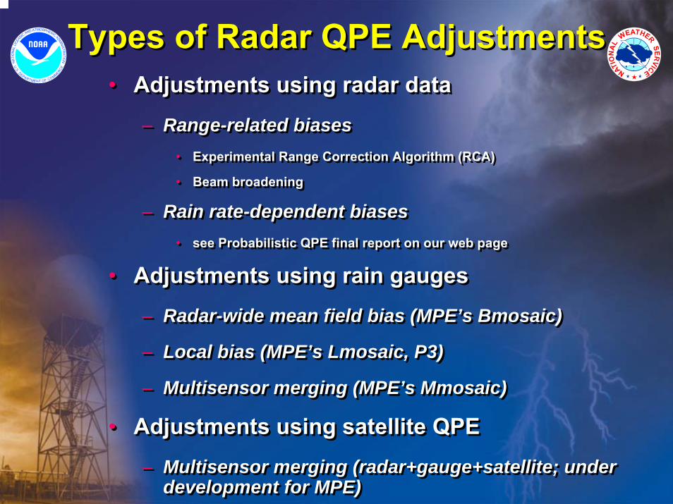
Types of Radar QPE AdjustmentsTypes of Radar QPE Adjustments• Adjustments using radar data
– Range-related biases• Experimental Range Correction Algorithm (RCA)
• Beam broadening
– Rain rate-dependent biases• see Probabilistic QPE final report on our web page
• Adjustments using rain gauges
– Radar-wide mean field bias (MPE’s Bmosaic)
– Local bias (MPE’s Lmosaic, P3)
– Multisensor merging (MPE’s Mmosaic)
• Adjustments using satellite QPE
– Multisensor merging (radar+gauge+satellite; under development for MPE)
• Adjustments using radar data
– Range-related biases• Experimental Range Correction Algorithm (RCA)
• Beam broadening
– Rain rate-dependent biases• see Probabilistic QPE final report on our web page
• Adjustments using rain gauges– Radar-wide mean field bias (MPE’s Bmosaic)
– Local bias (MPE’s Lmosaic, P3)
– Multisensor merging (MPE’s Mmosaic)
• Adjustments using satellite QPE
– Multisensor merging (radar+gauge+satellite; under development for MPE)

Radar Total Rain“DSP”
-single radar-polar grid
-no adjustments
PPSRange-correctedRadar Total Rain
“DSPR”-apply RCA
corrections scan-to-scan in PPS if desired
Range-correctedInc. Rain Mosaic
“RmosaicR”-mosaic multi-radarson 1/4th HRAP grid
PPS EMPE EMPE
Proposed End-to-End Sequence of Bias Correction Procedures in EMPE/MPN
Radar Rainrates“DHR”
-single radar-polar grid
-no adjustments
Range-correctedRainrates“DHRR”
-Apply RCAcorrections if desired
Range-correctedRainrate Mosaic
“RRmosaicR”-mosaic multi-radars
on 1/4th HRAP gridRai
n ra
tes
Rai
nfal
l
ORPG AWIPS
EMPE
Range-correctedRadar Increm. Rain
“RainR_d”-compute incremental rain for any duration d
by differencing
Range Adjustment Factor Array
“AFA”
RCA/CSSA
Not Yet Implemented
Implemented
PPS EMPE
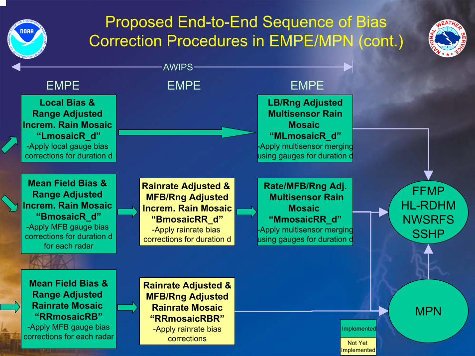
Rainrate Adjusted & MFB/Rng Adjusted
Increm. Rain Mosaic “BmosaicRR_d”-Apply rainrate bias
corrections for duration d
EMPE
Rainrate Adjusted &MFB/Rng Adjusted
Rainrate Mosaic “RRmosaicRBR”-Apply rainrate bias
corrections
Local Bias & Range Adjusted
Increm. Rain Mosaic “LmosaicR_d”
-Apply local gauge bias corrections for duration d
Mean Field Bias & Range Adjusted
Increm. Rain Mosaic “BmosaicR_d”
-Apply MFB gauge bias corrections for duration d
for each radar
EMPELB/Rng AdjustedMultisensor Rain
Mosaic “MLmosaicR_d”
-Apply multisensor mergingusing gauges for duration d
Rate/MFB/Rng Adj.Multisensor Rain
Mosaic “MmosaicRR_d”
-Apply multisensor mergingusing gauges for duration d
EMPE
Mean Field Bias &Range Adjusted Rainrate Mosaic “RRmosaicRB”
-Apply MFB gauge biascorrections for each radar
MPN
AWIPS
FFMPHL-RDHMNWSRFS
SSHP
Not Yet Implemented
Implemented
Proposed End-to-End Sequence of Bias Correction Procedures in EMPE/MPN (cont.)
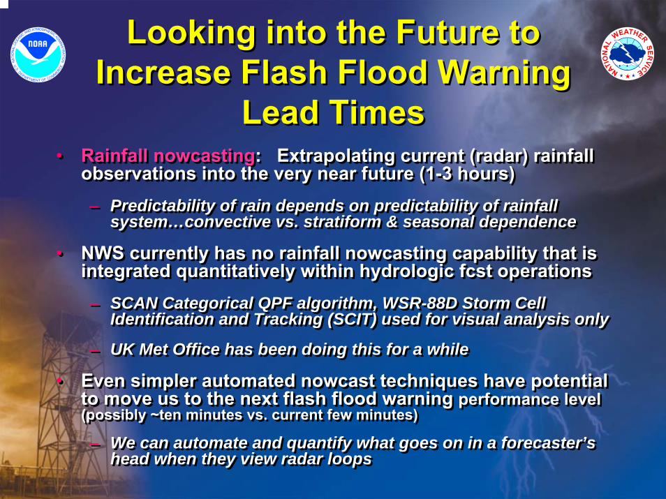
Looking into the Future to Increase Flash Flood Warning
Lead Times
Looking into the Future to Increase Flash Flood Warning
Lead Times• Rainfall nowcasting: Extrapolating current (radar) rainfall
observations into the very near future (1-3 hours)– Predictability of rain depends on predictability of rainfall
system…convective vs. stratiform & seasonal dependence
• NWS currently has no rainfall nowcasting capability that is integrated quantitatively within hydrologic fcst operations– SCAN Categorical QPF algorithm, WSR-88D Storm Cell
Identification and Tracking (SCIT) used for visual analysis only
– UK Met Office has been doing this for a while
• Even simpler automated nowcast techniques have potential to move us to the next flash flood warning performance level(possibly ~ten minutes vs. current few minutes)
– We can automate and quantify what goes on in a forecaster’s head when they view radar loops
• Rainfall nowcasting: Extrapolating current (radar) rainfall observations into the very near future (1-3 hours)– Predictability of rain depends on predictability of rainfall
system…convective vs. stratiform & seasonal dependence
• NWS currently has no rainfall nowcasting capability that is integrated quantitatively within hydrologic fcst operations– SCAN Categorical QPF algorithm, WSR-88D Storm Cell
Identification and Tracking (SCIT) used for visual analysis only
– UK Met Office has been doing this for a while
• Even simpler automated nowcast techniques have potential to move us to the next flash flood warning performance level(possibly ~ten minutes vs. current few minutes)
– We can automate and quantify what goes on in a forecaster’s head when they view radar loops
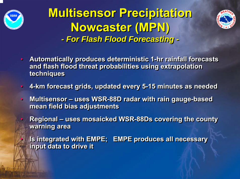
Multisensor Precipitation Nowcaster (MPN)
- For Flash Flood Forecasting -
Multisensor Precipitation Nowcaster (MPN)
- For Flash Flood Forecasting -
• Automatically produces deterministic 1-hr rainfall forecasts and flash flood threat probabilities using extrapolation techniques
• 4-km forecast grids, updated every 5-15 minutes as needed
• Multisensor – uses WSR-88D radar with rain gauge-based mean field bias adjustments
• Regional – uses mosaicked WSR-88Ds covering the county warning area
• Is integrated with EMPE; EMPE produces all necessary input data to drive it

History and Status of MPNHistory and Status of MPN• MPN is an extension of HL’s Flash Flood Potential (FFP)
algorithm– FFP was originally single-radar, single-sensor
– AHPS supported the upgrade to multiradar, multisensor using EMPE product input
• Initial AHPS funding proposal for MPN written by Fulton in 2002 and funded FY 2003-2006
• Project plan developed and distributed for review in 2002
• Initial MPN prototype was completed in 2004 by HSMB’sHydrometeorology Group (S. Guan, F. Ding, R. Fulton)
• In 2004, we set up a real-time 24x7 demonstration in HL for 5 WSR-88Ds in mid-Atlantic region (Sterling KLWX, Pittsburgh KPBZ, Charleston KRLX, Blacksburg KFCX, Wakefield KAKQ)
• Web page shows real-time graphical output products
• MPN project is in OSIP Stage 2
• MPN is an extension of HL’s Flash Flood Potential (FFP) algorithm– FFP was originally single-radar, single-sensor
– AHPS supported the upgrade to multiradar, multisensor using EMPE product input
• Initial AHPS funding proposal for MPN written by Fulton in 2002 and funded FY 2003-2006
• Project plan developed and distributed for review in 2002
• Initial MPN prototype was completed in 2004 by HSMB’sHydrometeorology Group (S. Guan, F. Ding, R. Fulton)
• In 2004, we set up a real-time 24x7 demonstration in HL for 5 WSR-88Ds in mid-Atlantic region (Sterling KLWX, Pittsburgh KPBZ, Charleston KRLX, Blacksburg KFCX, Wakefield KAKQ)
• Web page shows real-time graphical output products
• MPN project is in OSIP Stage 2
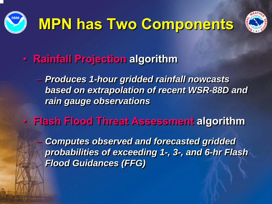
MPN has Two ComponentsMPN has Two Components
• Rainfall Projection algorithm
– Produces 1-hour gridded rainfall nowcasts based on extrapolation of recent WSR-88D and rain gauge observations
• Flash Flood Threat Assessment algorithm
– Computes observed and forecasted gridded probabilities of exceeding 1-, 3-, and 6-hr Flash Flood Guidances (FFG)

MPN Data FlowMPN Data Flow
RFC1 FFG Assessment
Projection
Multisensor Precipitation Nowcaster
User adaptable params.
Bias-adjrain ratemosaics
Bias-adj15-min rainfall
mosaics
RFC2 FFG
RFC3 FFG
GriddedFFG mosaic
Products
EMPE

MPN DetailsMPN Details
• Generates one-hour rainfall nowcasts on HRAP grid (~4 km) with 5-15 minute update frequency as needed
– Meager justification currently for going to higher spatial resolution
– Extending forecasts beyond 1 hour is easily doable, but accuracydegrades quickly beyond ~1 hour in summer convection
• Local pattern matching technique using two consecutive gridded radar rain rate mosaics ~15-20 minutes apart produces local storm motion vectors
– Vectors delineate storm motion at a ~20 km grid scale
– Automated vector quality control
• Advect and integrate current mean field bias-adjusted rain rate mosaic one hour into future using observed storm vectors
– Several progressive spatial smoothing options are available to minimize forecast error
• Local lagrangian storm growth and decay can be accounted for in forecasts if desired
Pt. 1: Rainfall Projection Algorithm

MPN Projection ProductsOne-hour Rainfall Forecast
MPN Projection ProductsOne-hour Rainfall Forecast

MPN Projection ProductsOne-hour Rain Rate Forecast
MPN Projection ProductsOne-hour Rain Rate Forecast

MPN Projection ProductsStorm Motion Vectors and Reliability
MPN Projection ProductsStorm Motion Vectors and Reliability

MPN DetailsMPN Details
• Compares both observed and forecasted rainfall with 1, 3, and 6-hr FFGs on the HRAP grid– Could be enhanced to do basin averaging if integrated into
FFMP
• Computes both observed and forecasted gridded probabilities of exceeding FFGs– Maximum exceedance probabilities of all three durations (1-hr,
3-hr, 6-hr),• e.g., 3-hr forecast exceedance probabilities are computed from 2
hours of past observed rain and 1 hour of forecast rain and thencompared with 3-hr FFGs
– “Storm-total” exceedance probabilities (Critical Rainfall Probabilities)
Pt. 2: Flash Flood Threat Assessment Algorithm

MPN Assessment ProductsFFG Exceedance Probabilities
MPN Assessment ProductsFFG Exceedance Probabilities
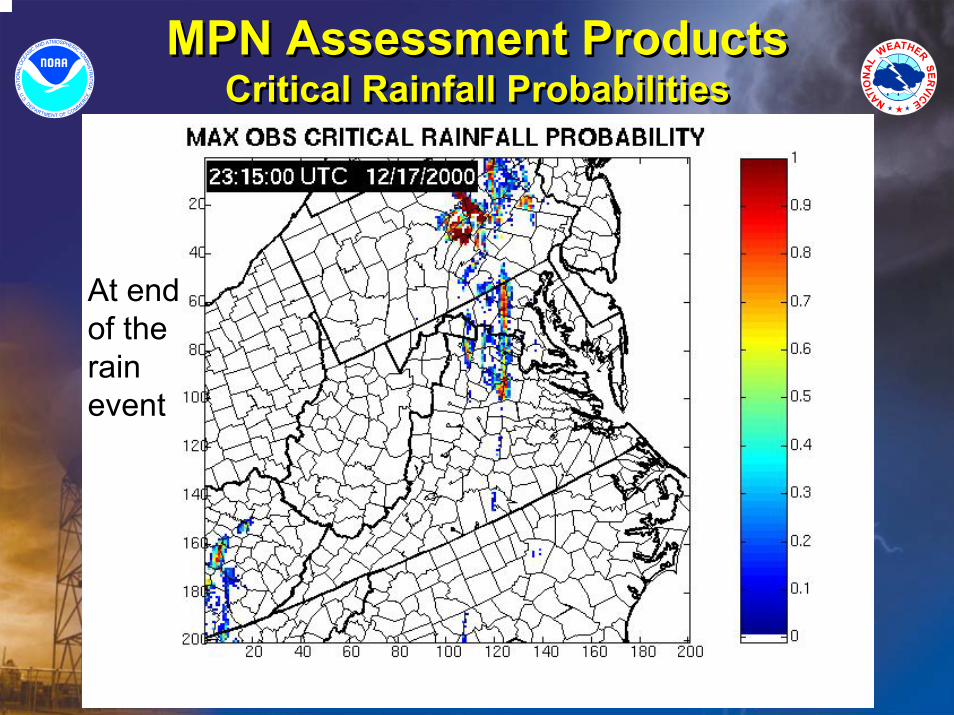
MPN Assessment ProductsCritical Rainfall Probabilities
MPN Assessment ProductsCritical Rainfall Probabilities
At end of the rain event

Real-time Web Pagehttp://www.nws.noaa.gov/ohd/hrl/hag/empe_mpn/
Real-time Web Pagehttp://www.nws.noaa.gov/ohd/hrl/hag/empe_mpn/
MPN products

MPN Verification:Are the Nowcasts Any Good?
MPN Verification:Are the Nowcasts Any Good?
• Verification of forecasted instantaneous rain rates and hourly forecast accumulations…
– Against radar observations (completed)
• Fulton and Seo (2000)
• Guan, Ding, Fulton, Kitzmiller (2005)
– Against rain gauge observations (in progress)
• Verification of forecasted instantaneous rain rates and hourly forecast accumulations…
– Against radar observations (completed)
• Fulton and Seo (2000)
• Guan, Ding, Fulton, Kitzmiller (2005)
– Against rain gauge observations (in progress)
Fulton and Seo, 2000: A prototype operational 0-1 hour radar-based Flash Flood Potential algorithm. 15th Hydrology Conference.
Guan, Ding, Fulton, Kitzmiller, 2005: Preliminary results for the 0-1 hour Multisensor Precipitation Nowcaster. 32nd Radar Meteorology Conference.

Example 1 – Visually ComparingForecasts and Observations
Example 1 – Visually ComparingForecasts and Observations
Obs.
Fcst.
NFL

Obs.
Fcst.
NFL
Example 2 – Visually ComparingForecasts and Observations
Example 2 – Visually ComparingForecasts and Observations

Comparison of average POD, FAR, and CSI of 1-hour accumulated precipitation
forecast > 5 mm between persistence and MPN
0
0.2
0.4
0.6
0.8
POD FAR CSI
PRSMPNStatistics
computed on HRAP grid
27 historical flash flood events examined from 18 locations around the U.S. over ten years +77%
-43%+106%
MPN Forecast Verification Against Radar Rainfall Observations: 1-hr Rainfall
MPN Forecast Verification Against Radar Rainfall Observations: 1-hr Rainfall

MPN Forecast Verification Against Radar Rainfall Observations: 1-hr Rainfall
MPN Forecast Verification Against Radar Rainfall Observations: 1-hr Rainfall
Bias=Σ(fcst rain)/Σ(obs rain)
Rain gauge data was not used

Using Rainfall Nowcasts in a Distributed Hydrologic Forecast
Model (HL-RDM)
Using Rainfall Nowcasts in a Distributed Hydrologic Forecast
Model (HL-RDM)
• Forecast hydrographs using 1-hr MPN rain nowcasts are consistently better than assuming zero QPF based on 9 intense rain events– Reed, Fulton, Zhang, Guan (2006)
• Demonstrated potential flash flood lead time gained
• A component of S. Reed’s HOSIP project “Distributed Hydrologic Modeling for Flash Flood Forecasting”
• Potential for use in Site Specific Hydrologic Predictor (SSHP)
• Potential for linking hydro forecasts to high-res GIS-based flood inundation mapping capabilities for emergency managers
Reed, Fulton, Zhang, Guan, 2006: Use of 4-km, 1-hr precipitation forecasts to drive a distributed hydrologic model for flash flood prediction. 20th Hydrology Conference.

• Lead times are computed relative to the simulated peak time.• All results shown are for CAVESP (90 km2) and single Event (7/2004)
CAVESP
0
20
40
60
80
100
120
0 2 4 6 8 10
Lead Time (hrs)
Abs.
% P
eak
Erro
r
QPF 0 QPF Pers
Lead Time = 4 hrs
Peak errors of different forecasts relative to simulated flows as a function of lead time
Lead Time = 3 hrs
Lead Time = 2 hrs
Hydrograph Forecast Accuracy at Different Lead Times (Reed et al. 2006)
0
50
100
150
200
250
7/2/04 12:00 7/3/04 0:00 7/3/04 12:00 7/4/04 0:00 7/4/04 12:00
Date
Flow
(CM
S)
0
20
40
60
80
Rai
nfal
l (m
m)
Simulated flow Observed flow 2 year floodFcst Time QPF - 7/3/2004 6 UTC QPF0 - 7/3/2004 6 UTCPers - 7/3/2004 6 UTC Precipitation
0
20
40
60
80
100
120
140
160
180
200
7/2/0412:00
7/2/0416:48
7/2/0421:36
7/3/042:24
7/3/047:12
7/3/0412:00
7/3/0416:48
7/3/0421:36
7/4/042:24
7/4/047:12
7/4/0412:00
Date
Flow
(CM
S)
0
20
40
60
80
Rai
nfal
l (m
m)
Simulated flow Observed flow2 year flood Fcst TimeQPF - 7/3/2004 5:00:00 AM UTC QPF0 - 7/3/2004 5:00:00 AM UTCPers - 7/3/2004 5:00:00 AM UTC Precipitation
0
20
40
60
80
100
120
140
160
180
200
7/2/0412:00
7/2/0416:48
7/2/0421:36
7/3/042:24
7/3/047:12
7/3/0412:00
7/3/0416:48
7/3/0421:36
7/4/042:24
7/4/047:12
7/4/0412:00
Date
Flow
(CM
S)
0
20
40
60
80
Rai
nfal
l (m
m)
Simulated flow Observed flow2 year flood Fcst TimeQPF - 7/3/2004 4:00:00 AM UTC QPF0 - 7/3/2004 4:00:00 AM UTCPers - 7/3/2004 4:00:00 AM UTC Precipitation
Lead time gained over zero QPF
Forecast time
Forecast time
Forecast time

National Average Annual Flash Flood Warning Lead Time
0
10
20
30
40
50
60
1987
1988
1989
1990
1991
1992
1993
1994
1995
1996
1997
1998
1999
2000
2001
2002
2003
2004
2005
Lead
Tim
e in
Min
utes
NEXRAD NEXRAD ImplementationImplementation
FFMPFFMPImplementationImplementation
Historical Performance of NWS Flash Flood Warning Lead TimeHistorical Performance of NWS Flash Flood Warning Lead Time

• Flash Flood Warning verification statistics are based on productissuance information and confirmation of actual flash floods by the local WFOs
– Flash Flood Warning Lead Time
– Flash Flood Warning Accuracy
FY03
Actual
FY04
Actual
FY05
Actual
FY06
Goal
FY12
GoalLead Time
(minutes) 41 48 54 48
89Accuracy (%) 89 89 88
51
91
Recent and Projected WFO Flash Flood Warning Performance
Recent and Projected WFO Flash Flood Warning Performance
EMPE and MPN, when integrated with other WFO hydrology tools, have the potential to greatly increase
future performance
EMPE and MPN, when integrated with other WFO hydrology tools, have the potential to greatly increase
future performance
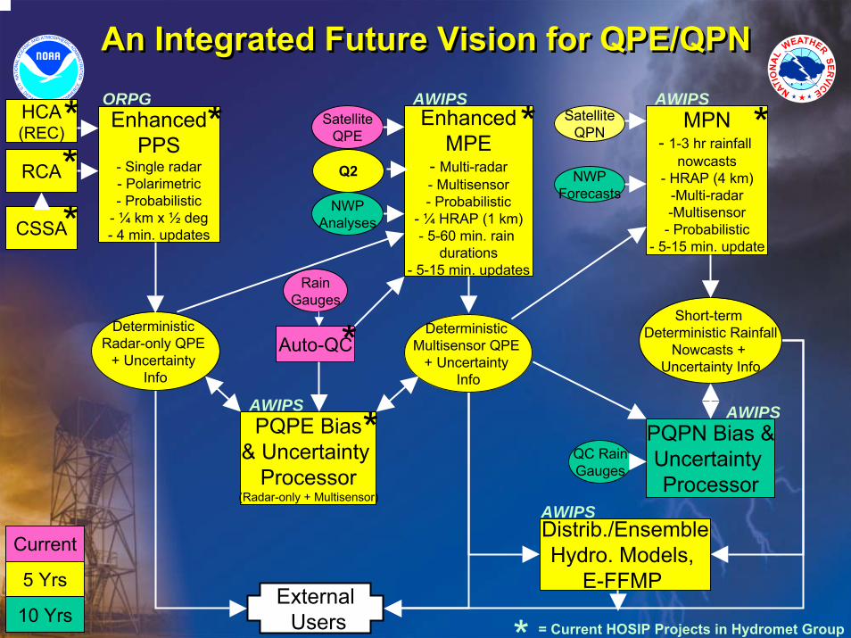
An Integrated Future Vision for QPE/QPNAn Integrated Future Vision for QPE/QPN
= Current HOSIP Projects in Hydromet Group
ExternalUsers
Distrib./EnsembleHydro. Models,
E-FFMP
AWIPS
Current
5 Yrs
10 Yrs
EnhancedMPE
- Multi-radar- Multisensor- Probabilistic
- ¼ HRAP (1 km)- 5-60 min. rain
durations- 5-15 min. updates
RainGauges
Auto-QC
SatelliteQPE
NWPAnalyses
AWIPS
*
*
*
EnhancedPPS
- Single radar- Polarimetric- Probabilistic
- ¼ km x ½ deg- 4 min. updates
HCA(REC)
RCA
CSSA
ORPG
*** *
Deterministic Multisensor QPE
+ Uncertainty Info
PQPE Bias& Uncertainty
Processor(Radar-only + Multisensor)
Deterministic Radar-only QPE
+ Uncertainty Info
AWIPS
*
MPN- 1-3 hr rainfall
nowcasts- HRAP (4 km)
-Multi-radar-Multisensor- Probabilistic
- 5-15 min. update
NWPForecasts
SatelliteQPN
Short-term Deterministic Rainfall
Nowcasts + Uncertainty Info
AWIPS
*
PQPN Bias &Uncertainty Processor
AWIPS
QC RainGauges
Q2
ConclusionConclusion
• The Enhanced Multisensor Precipitation Estimator and Nowcaster can enable improved WFO performance results and new diverse flash flood services
• The Enhanced Multisensor Precipitation Estimator and Nowcaster can enable improved WFO performance results and new diverse flash flood services

For more information on activities to improve WSR-88D rainfall estimation in
the Hydrology Lab…
For more information on activities to improve WSR-88D rainfall estimation in
the Hydrology Lab…
• Visit the Hydromet Group’s web page– http://www.nws.noaa.gov/oh/hrl/hag/hag.htm
• Visit our WSR-88D publications web page– http://www.nws.noaa.gov/oh/hrl/papers/papers.htm#wsr88d
– All the papers referenced herein are located there
• Visit the Hydromet Group’s web page– http://www.nws.noaa.gov/oh/hrl/hag/hag.htm
• Visit our WSR-88D publications web page– http://www.nws.noaa.gov/oh/hrl/papers/papers.htm#wsr88d
– All the papers referenced herein are located there
The End