Embed Size (px)
Citation preview

Engineering in Canada’s Northern Oceans
Research and Strategies for Development
A Report for the Canadian Academy of Engineering
Final
Ken Croasdale
Robert Frederking
Ian Jordaan
Peter Noble
First edition, April 2016
For print copies of this publication, please contact:
Canadian Academy of Engineering
55 Metcalfe Street Suite 300
Ottawa, Ontario K1P 6L5
Tel: 613-235-9056
Fax: 613-235-6861
Email: [email protected]
Registered Charity Number: 978-1-928194-02-6
This publication is also available electronically at the following address: www.cae-acg.ca
Permission to Reproduce Except as otherwise specifically noted, the information in this publication
may be reproduced, in part or in whole and by any means, without charge or further permission
from the Canadian Academy of Engineering, provided that due diligence is exercised in ensuring the
accuracy of the information reproduced; that the Canadian Academy of Engineering is identified as
the source institution; and that the reproduction is not represented as an official version of the
information reproduced, nor as having been made in affiliation with, or endorsement of the
Canadian Academy of Engineering. Opinions and statements in the publication attributed to named
authors do not necessarily reflect the policy of the Canadian Academy of Engineering.
ISBN: 978-1-928194-02-6
© Canadian Academy of Engineering 2016
Authors
This report was prepared for the Canadian Academy of Engineering by the following
authors.
Ken Croasdale, FCAE
President, K.R. Croasdale & Associates
Ken Croasdale has been active since 1969 in Arctic engineering. He spent 18 years with
Imperial Oil managing their Frontier Technology Group and several years with Dome
Petroleum and Petro Canada when they were active in the Beaufort Sea and East Coast
Canada. He has specialized in the design of offshore platforms and pipelines in ice. The
experience gained in Canada has been applied to the US, Russian and Kazakhstan offshore
regions. He is currently President of K.R. Croasdale & Associates. He is a graduate of
London University and a Fellow of the Canadian Academy of Engineering.
Robert Frederking, FCAE
National Research Council
Bob Frederking graduated from the University of Alberta in 1964. He did graduate studies
at the Universities of London and Illinois completing a Ph.D. in 1968. He joined the
National Research Council in 1970 and has conducted research on ice engineering, ice
mechanics and cold regions engineering. He has carried out laboratory, field and analytical
research on the forces generated by floating ice on offshore structures. He has served on
numerous advisory committees and has also assisted regulatory agencies in the assessment
of ice loading on structures such as the Beaufort Sea exploratory drilling platforms and the
Confederation Bridge.
He is a Fellow of Canadian Academy of Engineering and currently chairs the Canadian
Standards Association Technical Committee K157 that coordinates Canadian contributions
to the development of standards on offshore structures.
Ian Jordaan, FCAE
President, Ian Jordaan & Associates
Ian Jordaan is University Research Professor and Professor Emeritus at Memorial
University in St John’s, Canada. He specializes in probabilistic analysis and the mechanics of
solids. The main focus of his work is the determination of design loads for offshore
installations in the presence of ice, and he has contributed to the design of structures for
developments off the east coast of Canada, and in the Arctic, the Caspian Sea and the
Barents Sea. He has contributed to the development of design criteria for offshore
structures, and has chaired and participated in related commitees, including several in the
development of the International Standard ISO 19906 on Arctic Offshore Structures.
He is a Fellow of the Canadian Academy of Engineering. He received Bachelor’s and
Master’s degrees from the University of the Witwatersrand, Johannesburg, South Africa and
a Ph.D. from the University of London, King's College, U.K. He was elected Fellow of the
Royal Society of Canada in 2011.
Peter G. Noble, FCAE President & Senior Advisor, Noble Associates Inc.
Peter Noble first crossed the Arctic Circle in 1966 while working in Norway and in 1969 took
his new bride to Hay River where they built a tug and barge and sailed “down-north” on the
McKenzie River to the Beaufort Sea.
He is naval architect and ocean engineer with a wide range of experience in the international
marine and offshore industries, with a particular interest in the Arctic. His career has included
positions with shipyards; ship and offshore design consultants; offshore and marine research
and development companies; major classification societies and international oil companies.
He is a Fellow of the Canadian Academy of Engineering and has received numerous awards
and has published widely.
ExecutiveSummary
Theareasof studyareCanada’sNorthernOceans, theArcticand theAtlantic, andwaters and seas that are part of or adjacent to these oceans. These include thewaterswithin and around the CanadianArctic Archipelago, the various islands ofwhichareseparatedfromoneanotherandthecontinentalmainlandbyaseriesofwaterwayscomprisingtheNorthwesternPassages.Canada’sNorthernOceanscovera vast area stretching 4000km from the waters off Newfoundland populated byicebergstotheremoteArcticOceanoffthenortherncoastofEllesmereIslandandfromthere2000kmsouthwestwardtotheBeaufortSea.
The presence of ice in theNorthernOceans has always been themajor challengefacingCanadianslivingandventuringintotheregion.FirstNationsdevelopedverysophisticated ways of living in the North and of making use of ice and snow.Explorersanddeveloperswhocamelaterquicklyrealizedhowgreatanimpedimenticewas to their ambitions. Only in the last 70 years or so has the application ofscientific knowledge and engineering methods enabled transportation pathwaysandcertaindevelopmentactivitiestoproceed–albeitwithhighercoststhanintheSouth. With current trends ice may indeed become less formidable but it is ourperspectivethaticewillcontinuetodominateengineeringintheNorthernOceans.
The search for and development of mineral resources commencing in the mid‐twentieth century presented both challenges and opportunities for Canadianengineers. In addressing these opportunities, the case histories of which aredocumented in this report, Canadians became world leaders in engineering fornorthernoceansandhaveappliedtheirskillsinbothCanadaandelsewhere.
A survey of this expertise has been conducted as part of this study. Despite lessactivity than in the past, Canada’s northern engineering ability still exists and isbeingexercised,butmanyoftheexpertsareapproachingretirement.Thesupplyofyoungerengineersinthisspecializedareahasbeenadverselyaffectedbythecyclesofresourcedevelopment.Thischallengeisdiscussedinthestudyandsolutionsareoffered.
WhyaretheseissuesimportantforCanada?Thisstudysuggestsseveralreasons.
There are significant resources in Canada’s North which, if developedresponsibly,willcreatevalueforCanadians.
Inenablingnortherndevelopments,employmentandtrainingopportunitiesfor Canada’s Northern residents will be enhanced and they will also beempoweredbyparticipation.
Furthermore, maintaining and enhancing our knowledge base also givesCanadian engineers and engineering firms a competitive advantageelsewhereintheworldinbothprovidingconsultingservicesandincreatingjointventures.

ii
Finally,theabilitytomaintainsovereigntyandtounderstandandrespondtoclimatechangeintheNorthwillbeenhancedbymaintainingandexercisingourNorthernOceansengineeringcapabilities.
The technical emphasisof this report is the studyof engineeringneeds for futuredevelopmentinnorthernmarinewaters.ThefocusisprimarilyonnaturalresourcedevelopmentandinfrastructureneedsforotheractivitiessuchasArcticcommunityre‐supply,Arcticshipping,andmaritimesafetyandsecurity.
The study group conducted a brief review of climate change and in particular itsinfluence upon shipping. Conditions in the Northwest Passage are known to behighlyvariablefromyeartoyear.TheIntergovernmentalPanelonClimateChange(IPCC) findingof awarming trendand thinner ice is accepted,butanyuseof thistrendinplanningoftransportationandengineeringactivitiesmustbeconsideredinthelightofyear‐to‐yearvariability,andthepossibilityofoldiceinthepassagewaysof the Northwest Passage. In brief, IPCC findings are accepted but theirinterpretation in Arctic engineering is far from straightforward. Engineers mustaccountforallrelevantuncertaintiesintheirplanning.
Thestudycontinueswithareviewofrecentreports,includingtwofromtheCentrefortheNorth(CFN2011,2013).Thesereportsemphasizetheimportanceofclimatechange, infrastructure, emergency response and search and rescue, as well ascommodity prices, in northern development. Climate change will improve theaccessibilityofnorthernmarinewaters;anincreaseinshippingispossiblebuttherearecomplicatingfactors.Itisconcludedthat“thewaythattherisksandbenefitsofeconomic development are weighted and managed must make sense toNortherners, keep their interests front and centre, and effectively capture theNorthern context.” Leveraging public–private cooperation and partnerships isadvocated. “Boom‐bust” issues, for instance when mining activities createsubstantial activity, and then decline, can be an important issue in planning.Transportation infrastructure is significantly more expensive to develop inNorthern communities than in the South, and at present is sparse. Warming,permafrostdegradationanddecliningviabilityofwinterroadsmustbe taken intoaccount in new designs. The importance ofmarine transportation is emphasized.TheCentreforArcticResourceDevelopmentintheirArcticDevelopmentRoadmap(CARD 2013) focused on the oil and gas industry and consulted extensivelywiththat industry. The principal issues raised were environmental protection, icemanagement, icemechanicsand loading,station‐keeping in iceandenvironmentalcharacterization.
ForthesubjectreportaninventoryofCanadiancentresorientedtowardsNorthernresearch has been carried out, together with a detailed review of present‐dayCanadian expertise. Canadian contribution to codes and standards,many of theminternational, has been summarised. The report includes a set of case studies ofCanadian involvement in engineering for the following areas: Beaufort Sea, East

iii
Coast of Canada, Caspian Sea, Barents Sea, Voisey’s Bay, Arctic islands and pilotproduction, Arctic Pilot Project. An inventory of mineral resources and portinfrastructure has also been undertaken. Barriers to development are seen astransportation,infrastructure,energyandpeople.
PastuseoftheNorthwestPassageshasbeenreviewed,includingthevoyageoftheS.S. Manhattan, as has Canada’s icebreaker design and construction during the1970s.TheCanmarfleet,inparticulartheKigoriak,aswellastheBeaudrilfleethavebeen reviewed. Canada’s Emergency Evacuation and Rescue (EER) capability isviewedasbeingaworldleader.RecentshippingactivitieshavebeencentredontheMV Arctic, MVUmiak, MVNunavik. In Canada’s waters, destination shipping (forexample, shipping associated with mining activities) is seen as the importantactivity.Canadian infrastructure tosupportnorthernmarineactivities issparse incontrasttoRussia,whichhasyearroundactivitiesandconsiderableinfrastructure;RussiacontinuestoexpanditscapabilityforArcticmarineoperations.
Technicaluncertaintiesandbarrierstofutureresourcedevelopmentsarediscussedin this report. Several of these are already being addressed by industry and alsothroughcollaborativeactivitieswithinstitutessuchasC‐CORE,CARDandNRC,anduniversities such asMemorial. Federal funding is channeledmostly through NRCanduniversities.Highpriorityengineeringtopicsworthyofadditional,collaborativeandimaginativeworkinclude:
1. IceMechanicsandLoading
ThecruxofArcticoffshoreengineeringistounderstandicemechanicsandhowicegeneratesloadsonplatformsandvessels.Localandglobalicepressuresareneeded for design of both. There has been significant progress in this field byCanadianengineerswhohaveused large‐scalemeasurements taken todate todevelopnewtheoriesandmethods. Thesizeeffectismostimportantinglobaldesign and would benefit significantly from more full scale testing andmeasurementswiththickice.Improvedinformationonforcesinpackiceisalsoseen as a research need, as well as the mechanics of interaction of slopingstructureswiththickice.
2. FloatingPlatformsinIce
In deeper waters in the Beaufort and Labrador Seas, subsea production withpipelines back to shallowerwater is one possible scenario. Floating platformswillbeneededfordrillingandpossiblyforearlyproduction.Thereisaneedtomake these floaters as ice tolerant as possible in order to extend the drillingseasonandespeciallyforreliefwelldrilling. Theywouldbedisconnectedificeconditionsbecometoosevere.Theicecanalsobemanagedtoreduceiceloads.How the degree of icemanagement affects the ice loads and how to estimate

iv
themisstillasubjectofresearch;thereisacontinuedneedtoaddressthisissue.Forecastingoficeandmetoceanconditionsisanimportantcomponentintheseoperations, including such factors as pressured ice and sudden changes in thedirectionoficemovement.
3. ArcticShipping
Shipping is required for community access, tourism and transportation ofresources. Ice loads on ship hulls in heavy ice, and efficient ice‐worthypropulsion systems continue to be a worthy research topic. Navigationalinfrastructurewillneedattention.
4. TerminalsandHarbours
In ice covered regions terminals and harbours have different design andoperationalproblemsfromthoseintheSouth.Dockfacilitiesandberthedvesselshave to be designed for ice interaction. If toomuch protection is provided byenclosures,icebuild–upduetorepeatedshipstransitscanbeaproblemandicemanagementbecomescritical.
5. SafetyandEnvironmentalProtection
EscapeandevacuationfromvesselsandplatformsiniceisanissueuniquetotheNorth.Workhasbeenunderwayonthistopic,butimprovementswillbekeytomaintaining safety in harsher regions. Drilling of a “same‐season relief well”posesdifficultiesasoperationsmovefurthernorth,withshorterdrillingseasonsand more difficult ice conditions. The issue of oil spills is best addressed byprevention – which is dependent on sound design and impeccable operatingmethods. Even so, if oils spills do occur, it is paramount to understand theirimpactsandhowtomitigatethem.Icecanbeadvantageousincontainingaspill,butrecoveryoftheoilcanbemoredifficult.
6. EnvironmentalCharacterization
Safeandefficientdesignofengineeringstructuresandvesselsalsodependsonknowing the typesof iceandotherenvironmentalparametersprevailing inanarea. Climate change brings additional uncertainty in defining extreme icefeatures.Methodologiesareneeded toaddress thisuncertainty.Understandingandpredictinghowmulti‐yearicewillchangeinbothoccurrenceandthicknessishighlyimportant.
Northern involvement and education deserve attention within the context ofengineeringfortheNorthernOceans.Traditionalknowledgeisrecognizedtoplayarole in engineering and that there is benefit from close relationships betweenengineersandNorthernresidentsthroughentitiessuchastheCentrefortheNorth,

v
which provides a forum for research and dialogue on Northern and Aboriginalissues.
ThereisahighpercentageofyoungpeopleintheNorth,andfuturedevelopmentscan provide them with meaningful employment. Outreach programs arerecommended to raise awareness of science and engineering amongst Northernschoolchildren. Early awareness and creation of interest and excitementsurroundingpotential futureengineeringandscientificprojects isa foundationonwhich to build an educated population who can then be meaningfully involved.Improved access by Northerners to educational facilities in engineering andtechnologyisseenasapriority,andweadvocatethecommencementofinstructioninengineeringandtechnologyatCHARSlinkedtoexpertiseinotherUniversitiesinCanada, forexampleMemorialUniversity.Theconceptcouldbesimilar to theNy‐Ålesund research facility in Svalbard, which is managed by the Norwegiangovernment.
One of the themes of this study has been to show that significant advances inknowledgeflowfrom“doing”ratherthan“discussing”.Resourcedevelopmentswilloccurwithoutintervention,iftheeconomicsarefavourableandregulationsarefair.Nevertheless, there are infrastructure, collaborative research and communityprojects which, if encouraged and funded, can enhance Northern engineeringcapabilities. Theteamproposes forconsiderationseveral“visionary”projectsandprogramslistedbelow.
1. ArcticLNG—CleanGreenFuelfortheNorth
TheArctichasanabundantsupplyofnaturalgasbothintheBeaufortSearegionand in theArcticArchipelago.Arcticcommunitiesandactivitiesneed fuel. It isproposed to develop an Arctic liquified natural gas (LNG) public–privatepartnershiptosupplyLNGbothforbothfuellinggovernmentArcticoperationsand supplying local community needs. This would provide clean green Arcticfuelthatwould,forexample,allowyearroundicebreakeroperations.
2. MobileArcticEngineeringResearchPlatform
In this concept an iceworthy ship would be developed to be the engineeringexperiment itself, rather than a platform for science laboratories. Ice transitexperiments, hull and propeller loads, study of towing of arrays in ice, icemanagementstrategydevelopment,experimentstodevelopsupportofsub‐seadevelopmentsinicearepossiblefunctions,withNanisivikasapossiblenorthernbase.
3. CanadianArcticRailwayalongtheMcKenzieValleyfromHayRivertoInuvik
A Canadian Arctic Railway, possibly fueled by LNG,would provide a two‐waysystemthatcouldbeusedtodelivermaterielfornorthernconstruction,aswellasfuelandotheressentialsforlocalcommunitiesatpresentservicedbysummer

vi
barge traffic on the McKenzie River. The system could bring Arctic oil toSouthernmarkets,andtherailroadwouldprovideastronglogisticslinktotheWestern Arctic, improving infrastructure and reinforcing Canadian Arcticsovereignty.Further, thesystemwouldallowfordevelopmentofothernaturalresourcesalongitsroute,suchasminingandforestproducts.
4. InternationalArcticOcean‐SpaceEngineeringExperimentalStation(IAOSEES)
A permanent base is proposed on Hans Island, which is currently disputedterritory in theKennedyChannelbetweenCanadaandDenmark.The IAOSEES(pronouncedEye‐Oh‐Seas)wouldbejointlymanagedbyCanadaandDenmarkasasharedfacilityavailabletomembersoftheArcticCouncil.Thereisaneedforlarge scale experimentation to further advance Arctic marine and offshoreengineering.
Arctic sovereignty requires a strong presence in the region. A sovereign state isrepresented by one centralized government that has supreme independentauthority over a geographic area. There are responsibilities associated with thisauthority.ForanArcticstateinthe21stcentury,theseresponsibilitiescanonlybesatisfied by the extensive use of technology, including ships, aircraft and remotemonitoringsystems.ThepolaricebreakerCCGSDiefenbakerwillbeavailablewhencompletedinsomeyears’time;inthemeantimeCanadahasverylimitedcapability.The Arctic Offshore Patrol Vessels now being designed and built have limited icetransiting capability. Canada is ill‐prepared to address any future challenge to itssovereignty in the Arctic. A parallel approach to exerting sovereignty is to beeconomically and scientifically active in the region. In this context, the initiativessuggestedaboveanddetailedinthisreportwouldachievemuchtowardsthisend.

vii
Contents
EXECUTIVESUMMARY.............................................................................................................................i
1OverviewofCanada’sNorthernOceans.......................................................................................1
1.1IntroductoryComments.............................................................................................................1
1.2ClimateChange...............................................................................................................................4
1.2.1SeaIceandForecasts...........................................................................................................4
1.2.2Uncertainty,VariabilityandPossibleTrends...........................................................8
1.2.3Permafrostandiceroads...................................................................................................9
2CanadianActivitiesandEngineeringinNorthernOceans................................................10
2.1CaseStudiesshowingCanadianExperience...................................................................10
2.1.1Introduction..........................................................................................................................10
2.1.2OverviewofCanadianProjectExperience..............................................................10
2.1.3ConclusionsfromCaseStudies.....................................................................................18
2.2CanadianContributionstoCodesandStandards.........................................................18
2.3CanadianExpertiseonNorthernEngineering...............................................................20
2.3.1Origins.....................................................................................................................................20
2.3.2ASurveyofCurrentCapabilities..................................................................................21
2.4InventoryofCanadianCentresOrientedtowardsNorthernResearch...............24
2.4.1ArcticNet................................................................................................................................24
2.4.2CentrefortheNorth(CFN)............................................................................................24
2.4.3CanadianPolarCommission(GovernmentofCanada).....................................24
2.4.4CanadianHighArcticResearchStation(CHARS).................................................24
2.4.5C‐CORE,LOOKNorth&CARD(centreswithinC‐CORE)....................................25
2.4.6CanadianNetworkofNorthernResearchOperators.........................................25
2.4.7ArcticInstituteofNorthAmerica(atUniversityofCalgary)..........................25
2.4.8NRCArcticProgram..........................................................................................................25
2.4.9ProgramofEnergyResearchandDevelopment(PERD)..................................25
2.4.10PolarContinentalShelfProgram(PCSP)...............................................................26
2.4.11BeaufortRegionalEnvironmentAssessment(BREA)2011‐14..................26
2.4.12EnvironmentalStudiesResearchFunds(ESRF),CAPPsupported............26

viii
2.4.13CanadianInternationalCentrefortheArcticRegion......................................26
2.4.14IndustryandConsultants.............................................................................................26
2.5ReviewofRecentReports.......................................................................................................27
2.5.1 Centre for the North (CFN) ChangingTides: Economic Development inCanada’sNorthernMarineWaters(Fournier,S.andCaron‐Vuotari,M.,2013)27
2.5.2 CFN Northern Assets: Transportation Infrastructure in RemoteCommunities(Bristow,M.andGill,V.,2011)...................................................................28
2.5.3CFNFutureofMining.......................................................................................................29
2.5.4CCANorthernOceanScienceinCanada:MeetingtheChallenge,SeizingtheOpportunity.....................................................................................................................................29
2.5.5 True North: Adapting Infrastructure to Climate Change in NorthernCanada................................................................................................................................................30
2.5.6ArcticMarineShippingAssessment(AMSA)2009(ArcticCouncil)............30
2.5.7FromImpactstoAdaptation:CanadainaChangingClimate2007..............30
2.5.8ThePast isAlwaysPresent:ReviewofOffshoreDrilling in theCanadianArctic(NationalEnergyBoard,2011)..................................................................................31
2.5.9CARDArcticDevelopmentRoadmap(CARD,2012)...........................................31
3FutureOpportunitiesandChallenges.........................................................................................32
3.1Overview.........................................................................................................................................32
3.2InventoryofMineralResources...........................................................................................32
3.2.1Hydrocarbons......................................................................................................................33
3.2.2Minerals.......................................................................................................................................34
3.2.3Constraints.................................................................................................................................35
3.3DevelopmentScenariosandChallenges...........................................................................35
3.3.1Hydrocarbons......................................................................................................................35
3.3.2Minerals(Mining)..............................................................................................................40
3.4ShipsandShipping.....................................................................................................................41
3.4.1EarlyBeginnings.................................................................................................................41
3.4.2TheNorthWestPassage.................................................................................................41
3.4.3The1970s–AZenithofCanadianicebreakerDesign&Construction.......43
3.4.4CurrentNorthernWatersShippingActivity...........................................................45
3.4.5ShipsinSupportofSovereignty...................................................................................48
3.4.6ArcticMarineEmergencyEvacuationandRescue..............................................49
3.4.7ConclusiononShipsandShippinginCanada’sNorthernWaters.................50

ix
3.5Infrastructure...............................................................................................................................50
3.6NorthernInvolvementandEducation...............................................................................51
4Recommendations..............................................................................................................................53
5References..............................................................................................................................................57
AppendixA:NotefromIPCC,2013(SummaryforPolicymakers)....................................61
A.1 ObservedChangesintheClimateSystem...................................................................61
A.2 DriversofClimateChange.................................................................................................61
A.3 UnderstandingofClimateSystemanditsRecentChanges.................................62
A.4 FutureGlobalandRegionalClimateChange.............................................................62
AppendixB:CaseHistories.................................................................................................................64
B.1 Introduction.............................................................................................................................64
B.2 Imperial‐Dome‐GulfExploration–BeaufortSea.....................................................64
B.3 TheArcticIslands:ExplorationandPilotProduction...........................................72
B.4 PolarisMineProject–LittleCornwallisIsland........................................................74
B.5 ArcticPilotProject–LNGfromtheArcticIslands..................................................77
B.6 Voisey’sBayCaseStudy.....................................................................................................84
Background......................................................................................................................................84
IceConditions.................................................................................................................................84
Marineterminal.............................................................................................................................85
Shipandshippingoperation....................................................................................................86
B.7 EastCoastDevelopment:WhiteRose...........................................................................87
B.8 KashaganFieldDevelopment–NorthCaspianSea................................................91
B.9 ShtokmanField:IcebergloadsforfloaterinBarentsSea....................................94
Introduction.....................................................................................................................................94
Modelling..........................................................................................................................................95
AppendixC:APOAProjectlistingfromGlenbowMuseumwebsite..................................99
Appendix D: Inventory of Canadian Centres Oriented towards Northern Research......................................................................................................................................................................111
D.1 ArcticNet............................................................................................................................111
D.2 CentrefortheNorth(CFN)........................................................................................111
D.3 CanadianPolarCommission(GovernmentofCanada).................................113
D.4 CanadianHighArcticResearchStation(CHARS)............................................113
D.5 C‐CORE,LOOKNorth&CARD(centreswithinC‐CORE)..............................115

x
D.6 CanadianNetworkofNorthernResearchOperators.....................................116
D.7 ArcticInstituteofNorthAmerica(atUofCalgary)........................................116
D.8 NRCArcticProgram......................................................................................................116
D.9 ProgramofEnergyResearchandDevelopment(PERD)..............................117
D.10 PolarContinentalShelfProgram(PCSP).........................................................118
D.11 BeaufortRegionalEnvironmentAssessment(BREA)2011‐14............118
D.12 EnvironmentalStudiesResearchFunds(ESRF),CAPPsupported......119
AppendixE:ReviewofRecentReports......................................................................................121
E.1 CFN Changing Tides: Economic Development in Canada’s NorthernMarineWaters(Fournier,S.andCaron‐Vuotari,M.,2013).....................................121
E.2 CFN Northern Assets: Transportation Infrastructure in RemoteCommunities(Bristow,M.andGill,V.,2011)................................................................126
E.3 CFNFutureofMining...................................................................................................128
E.4 CCANorthernOceanScienceinCanada:MeetingtheChallenge,SeizingtheOpportunity...........................................................................................................................131
E.5 True North: Adapting Infrastructure to Climate Change in NorthernCanada.............................................................................................................................................131
E.6 ArcticMarineShippingAssessment(AMSA)2009(ArcticCouncil).......131
E.7 FromImpactstoAdaptation;CanadainaChangingClimate2007.........132
E.8 ThePast isAlwaysPresent:ReviewofOffshoreDrilling in theCanadianArctic(NationalEnergyBoard,2011)...............................................................................132
E.9 CARDArcticDevelopmentRoadmap(CARD,2012)......................................132
AppendixF:PreviousPlanningstudies(OilandGas)..........................................................133
AppendixG:NaturalResources.....................................................................................................135
G.1 Sources....................................................................................................................................135
G.2 Preface....................................................................................................................................135
AppendixH:ListofwellsdrilledinCanadianBeaufortSea..............................................140
AppendixI:MineralsandOilandGasMap...............................................................................142

1
1OverviewofCanada’sNorthernOceans
1.1IntroductoryComments
Three great oceans – the Atlantic, the Arctic and the Pacific – surround Canada(Figure1.1).Theconcernofthepresentstudyisthetwonorthernoceans,theArcticand Atlantic. The study includes the waters that are part of these oceans: theBeaufort Sea as part of the Arctic Ocean; the Labrador Sea and the Hudson andBaffinBays,aspartoftheAtlanticOcean,aswellastheDavisStrait,anorthernarmoftheLabradorSea.ThestudyincludesalsoallofthewaterswithinandaroundtheCanadianArcticArchipelago.Thevariousislandsareseparatedfromeachotherandthe continental mainland by a series of waterways comprising the NorthwestPassages.
The presence of ice in theNorthernOceans has always been themajor challengefacingCanadianslivingandventuringintotheregion.Icecanbepresentintheformofvariousicefeaturesthatneedtobeunderstoodbyengineersandmariners.IntheArctic Ocean, during a typical nine‐month winter, ice will form and grow to athicknessofabout1.5–2m.Exceptclosetoshore,theicemovesundertheactionofwindsandcurrentsandcanbesubjecttopressurewhichcausespressureridgestoform.Dependingonthedegreeoficepressureandthethicknessoftheiceattheircreation, Arctic pressure ridges can be over 40m thick at their extreme; they aresignificantobstacles toshipsandcan imposesignificant loadsonplatforms.Whentheygroundinshallowwater,theyscourtheseafloor,creatinghazardstopipelines.
In southernArcticwaters, during the summer, the ice formed in the priorwintermaymeltaway.Inmorenortherlyparts,theicenormallysurvivestheshortsummerand is subject to further growth during the next winter. Several cycles of thisfreezingandmeltingleadstotheformationofmulti‐year(MY)ice,whichintheHighArcticwillachieveanequilibriumthickness in therangeof4–5m.Pressureridgesaresubjecttosimilarprocesses.Inthesouththeycanmeltawayeachsummer,butinthenorththeyconsolidateintosolidmulti‐yeariceridges.Theseridgesarenotasthick as first‐year (FY) ridges (say about 20–25m thick), but are of solid ice andrepresentverysevereicefeaturesfordesign.
TheamountofMYiceintheArcticOceanvariesfromyeartoyearandisespeciallysensitive to the export of Arctic ice through the Fram Strait. Aswill be discussedlaterunderclimatechange,inrecentyearsthisexportappearstohavebeenhigherthan in past decades, resulting (together with the warming trend) in an overallthinningofArcticOceanice.
OthericefeaturescanalsoexistintheNorthernOceans.Theseincludeicebergsandiceislands,bothofwhicharealsoveryformidableforthedesignandoperationsofplatforms and ships. Icebergs are not common in Canada’s Arctic Ocean, but the

2
occasional iceislandoccurs. IceislandsarecalvedfromiceshelvesinthefiordsofthenorthcoastofEllesmereIsland.Theseiceshelvesgrowslowlybutcanattainathicknessupto60–100m.Aftercalving,iceislandscirculatewiththeArcticpackiceandovertimebecomethinner.Nevertheless,evenat30–40mthicknessandseveralkilometresacross,theyareclearlyverychallengingfeaturesfordesignandaretobeavoidedbyvessels.
IcebergsoccurmostlyoffCanada’sEastCoastallthewayfromEllesmereIslandtoNewfoundland.TheyoriginatefromtheglaciersofGreenlandandNorthernCanada.Icebergs can be several hundredmetres in draft andmillions of tonnes in mass.Again, they present a formidable challenge to offshore platform design andoperations.
RegionssuchasHudsonBayandtheGulfofSt.Lawrencearesubjectonlytoannualice.Evenso,thisicecangrowupto1–1.5mthick,whilepressureridgesupto15–20mcanoccurwithinthepack.
During the late1950sand1960s theCanadianArcticwasof strategic geopoliticalimportance,andmostresearchrelatedtomilitaryrequirementsforsurveillanceandlogistics. In the 1970s and 1980s the driver for researchwas exploration for andpotential production of oil and gas and minerals. The 1969 voyage of the SSManhattan through theNorthwestPassagewasastimulus forresearchrelating tothesafetyofshipping intheCanadianArctic.Thework focusedon iceclimatologyand naval architecture (hull strength and power requirements). The petroleumindustry’s interest in offshore oil and gas exploration drove extensive researchactivities into the ice environment, ice effects on offshore drilling activities anddevelopment of suitable engineering solutions. This researchwas funded by andlargelyconductedbystaffwithinthepetroleumindustry. The1990ssawreducedresearchintheCanadianArctic,butthishasagainincreasedinthe21stcentury.
The technical emphasisof this report is the studyof engineeringneeds for futuredevelopmentinnorthernmarinewaters.ThefocusisprimarilyonnaturalresourcedevelopmentandinfrastructureneedsforotheractivitiessuchasArcticcommunityre‐supply, Arctic shipping, and maritime safety and security. These activities areconsideredfromtheperspectiveofengineeringdesignneeds.Designwithregardtoice loading is governed by international codes and standards, for example ISO19906:2010,PetroleumandNaturalGas Industries—ArcticOffshore Structures andthe IACS—Unified Requirements for Polar Class Ships. The latter applies to shipsconstructedofsteelandintendedfornavigationinice‐coveredpolarwaters,andisin theprocessofbeing introduced intothe IMOPolarCode. InCanadatherelevantstandard is embodied in the Arctic Shipping Pollution Prevention Regulations(ASPPR).
The codes and standards just described include methods for design andconstruction,andthepresentreportiscomposedasaconstructiveinputforfuture

3
development of these documents. Canadian engineers played key roles in thedevelopmentof the ISOand IACScodes.This reportalsodealswith infrastructureneeds,aswellastheremotenessandextremeweatherconditionsofarcticregions.Climate change ismodifying ice conditions, the engineering implications ofwhichwillbeconsidered.Thelackofgeologicalandhydrographicdatainnorthernregionsisalsoaddressed.
Engineering expertise and designmethods developed in the past in Canada havebeen successfullyapplied tootherareas suchas theCaspianSea, theBarentsSea,theChukchiSeaandmanyotherregionsincludingtheKaraSeainRussia.
This study makes recommendations on the investments in research required todevelop engineering approaches and codes for safe and efficient developments inCanada’sNorthernOceansandwillincludeperspectivesontheneedtoeducateandtrainengineers inArctictechnologies. It is intendedtobecomplementarytootherinitiatives such as those underway by Centre for The North and the Council ofCanadianAcademies.Itsfocusisonengineeringanditsroleinfutureactivities.
Figure1.1:Canada’snorthernwaters.(http://atlas.gc.ca/)

4
1.2ClimateChange
The Intergovernmental Panel on Climate Control (IPCC) Fifth Assessment Report(IPCC,2013)notesthefollowing:
Warmingof the climate system isunequivocal, andhasbeenongoing sincethe1950s.
Theatmosphereandoceanhavewarmed,theamountsofsnowandicehavediminished,sea levelhasrisen,andtheconcentrationsofgreenhousegaseshaveincreased.
AsummaryofIPCC2013isgiveninAppendixAtothisreportanditsfindingsarewell accepted by the writers of the present report. At the same time, there arevariousfactorsthat introduceuncertainty,whichmustbetakenintoaccountinanengineeringassessment.Someofthesearesummarizedinthefollowingsections.
Itisnottheintentofthisstudytoreviewanddebatethevariousforecastsofclimatechange intheNorth.Changes in the iceregimehaveoccurred insomeregionsbutnot in others.How the futurewill unfold is subject to uncertainty, and this is thechallengetoNorthernengineeringactivities.
1.2.1SeaIceandForecasts
Figure1.2showsthedeclineinSeptemberandFebruaryseaicecoverintheArctic.Thetrendisindicativeofastrongreductioninsummerseaicecover,buttherearemanyfactorsthatshouldbetakenintoaccount intermsofmakinganengineeringassessment. In Figure1.2,most of the decline occurs after about 1997. There aresomegroundstobelievethatfluxthroughFramStraitwasinvolvedinthedeclineinsubsequentyears.Warmingisundoubtedlya factorinthereductionofsea ice,yetflushing through Fram Strait is also a well‐accepted factor, and for exampleacknowledgedinworkofStroeveandothers(2014).
Smedsrudet al. (2011) state that “Thehigh sea ice areaexportmusthavebeenasignificantcontributortothelowSeptemberseaicecoversobservedinrecentyears.The sea ice areaexport in2009and2010was lower than for thepreviousyears,2005,2006,2007and2008,perhapsindicatingthattheseaiceexportmayreturntomore moderate levels again soon.” The engineer has to consider all potentialadverse futurescenarios fordesign; thepossibilityof iceexport throughtheFramStraitreturningtonormal(withsubsequentbuild‐upagainofmulti‐yearice)cannotbe discounted, even though this may be considered unlikely by some. Figure 1.3showstheiceextentforthemonthsJunetoOctoberandthat2012hadthelargestsummer retreat since satellite observationswere available. Figure 1.2 shows thelargevariabilityandthatthesummerretreatswerenotasgreatin2013and2014.Therateofdeclineandvariationiniceextentismuchsmallerinthewintermonthsthaninthesummer.

5
Theliteratureindicatesthatthereisconsiderableuncertaintyinforecastsofarcticsea ice cover; seeStroeveetal. (2014)andWilsonetal. (2004), forexample.Thelatter reference considers five Global Climate Models (GCMs) and notes that theCanadian model forecast the disappearance of summer ice by 2070, while theNational Center for Atmospheric Research (NCAR) model forecast the ice extentremainingconstant(WalshandTimlin,2003).Wilsonetal.considertheNorthwestPassage(NWP)shippingroutes(Figure1.4).SeaicepredictionswereconsideredtobelessdependableandindeedinadequatefortheCanadianArcticArchipelagoandthepassagewaysbetweentheislands.SomeareassuchasM’ClureStraitcanremainblockedbyoldiceinmostyears.
ThisissupportedbytheworkofMelling(2002,2013).Melling(2002)studiedpackiceandrelevantclimatevariablesoftheCanadianArcticArchipelagonorthofParryChannel.PackiceispresentwithintheCanadianArcticArchipelagothroughouttheyear.Thesouthernandeasternregionsmayclearwhollyorinpartbylatesummer;iceconcentrationsintheSverdrupBasinarealwayshigh.Theextremedifficultiesofnavigation and the harsh climate have inhibited study of the marine cryosphere.“Scientificknowledgeissuperficialandincomplete”.
Multi‐year ice is formed in the zone of heavy ridging along the periphery of theBeaufortgyreandisimportedintotheSverdrupBasin.Melling(2002)suggeststhatwarmingclimatemightnotbringlightericeconditionstonorthernCanadianwaters.Very heavy multi‐year ice is at present blocked in winter by pack ice in thenorthwestern entry points and the southern exit from the Sverdrup Basin. Thick,heavilyridgedmulti‐yearicefromtheArcticOceanissloweddownbythisprocessinitsmovementthroughtheCanadianArcticArchipelago.Inawarmerclimate,theice bridges that ring the SverdrupBasinwill beweaker, and heavy icewillmovemorequicklythroughtheBasin.ThefluxtoNorthernshippingrouteswillincreasewithincreasedmulti‐yearice.
Inthe2013paper,Mellingshowedacomparisonofmeanvaluesofthicknessfromsystematicdrillingintheareanorth‐westofPennyStraitduringthe1970s(Melling2002)withtherangeofvaluesestimatedforthesametimeofyearfromthesonarmeasurements in 2009. The average thickness of sea ice in the vicinity of PennyStrait was found to be similar to the values of the 1970s. See Figure 1.5. Theserecentdatadonotdemonstrateachange in thicknessof thepredominantlymulti‐yeariceinthisareaduringthelast40years.Howelletal.(2013)confirmedthatthepresenceofMY ice in theCanadianArcticArchipelagooriginating from theArcticOceanhasbeenmaintainedandincreasedsince2005,attributedtoincreasedopenwaterareawithintheCanadianArcticArchipelagothathasprovidedmore leewayforinflowtooccur.Pizzolataetal.(2014)studiedpossiblecorrelationbetweenthedecline in sea ice and shipping activity; between 1990 and 2012, statisticallysignificant increases in vessel traffic were observed within the Northern CanadaVessel Traffic Services Zone (NORDREG), but overall the correlations were notstrong.

6
Figure1.2:Arcticseaiceextent
(ftp://sidads.colorado.edu/DATASETS/NOAA/G02135/)
Figure1.3: ArcticseaiceextentasofSeptember30,2013,withdailyiceextentdataforthepreviousfiveyears.Thegreyareaaroundtheaveragelineshowsthetwo
standarddeviationrangeofthedata.(http://nsidc.org/arcticseaicenews/2013/10/a‐better‐year‐for‐the‐cryosphere/:)

7
Figure1.4:ArcticseaiceextentgraphupdatedasofOctober25,2014
(http://nsidc.org/arcticseaicenews/2013/10/a‐better‐year‐for‐the‐cryosphere/:)
Figure1.5:TheNorthwestPassages
(http://en.wikipedia.org/wiki/Northwest_Passage)

8
Figure1.6:Track‐meanicethicknessfromdrill‐holesurveysofnorthwestofPennyStraitduringlatewinterinthe1970s,comparedwithvaluesbasedon2009data
[shadedbandis±δ](Melling2013)
1.2.2Uncertainty,VariabilityandPossibleTrends
Theprior discussionhighlights the variability anduncertainty associatedwith iceconditions.TheconditionsintheNorthwestPassageareknowntobehighlyvariablefromyeartoyear.TheIPCCfindingofawarmingtrendandthinnericeisaccepted,but any use of this trend in planning of transportation and engineering activitiesmust be considered in the light of year‐to year variability, and, as noted, thepossibilityofoldiceinthepassageways.Inbrief,theIPCCtrendsareaccepted,butinterpretation in Arctic engineering design and marine operations is far fromstraightforward.
Thevariabilityof ice conditions iswellknown,andWilsonetal.note thata “falsesenseofoptimism”mightbegeneratedregardingthefutureshippingintheCanadianArctic.Old icemightbepresentatany timeandpresentahazard.Engineersmustaccount for all relevantuncertainties in theirplanning.As a result, a conservativeapproach isadvocated; inotherwords,as inotherengineeringdesignsofsystemsforthefuture,itisprudenttoplanfortheworst.
For example, the engineer is required to consider ice features in design thatwillprevail over the lifetime of a facility, or over some specified return period. If weknowfromrecentsurveysthatthekindsoficefeaturesdescribedatthebeginningof this section exist, then even though the facilitymay be used over the next sayfortyyears,thedesignicefeaturesareclearlydominatedbywhatareseentoday–eveniffutureicefeaturesmaybelesssevere.Furthermore,uncertaintrendswhichmay lead tomore severe conditionshave tobe accounted for, even if notproven.These trends include water level changes and potentially a more severe waveclimateificecoverisdiminished.

9
Eventrends inthicknessreductionmaynotcontinueandthereforecannotbenefiteitherdesignor futureplannedoperations.Apparently, the thickness reduction intheArctic Basin is strongly influenced by the increased export of ice through theFramStrait.Itisnotclearifthiswillcontinueorevenreverse.Asnotedearlier,thethicknessofmulti‐yeariceinthechannelsoftheArcticIslandsappearsnottohavechanged in the past 40 years. This does not support thickness reduction due towarming. That said, we do not dispute the predictions, except in the context ofuncertaintyandapparentanomalies.
Finally,basedonourexperienceinotherregionswhere icecompletelydisappearsin the summer, even if this does occur in theArctic, thewinter ice regimeatwillcontinuetobea formidableobstacleandchallenge.Asearlierdescribedwewouldexpect to continue to have first year ridges up to 40m thick; possibly thickerbecauseof increased icemotionandwinddriven internal icepressure.Touse theterm “ice free” for theArctic basin, in the context of offshore engineering, is verymisleading.
1.2.3Permafrostandiceroads
Thedegradationofpermafrostduetowarmingtrendsismostlyaland‐basedissueand therefore is not a topic for this study. Nevertheless, the issue has somerelevancetotheoceansaswell.
In permafrost zones, foundations and winter roads are engineered to rest uponfrozengroundandmaintain that condition.Warming temperatures causeareasofdiscontinuous permafrost to move further north, with regions of thawingpermafrost.Theresultisslumpingoftheground,tiltedtrees,sinkholes,andrelateddisturbances, along with declining viability of winter roads. This can have asignificant impact on Northern communities and resource development projectsthatrelyonwinterroads.Typically,theseroadsareusedbeginninginNovemberorDecemberandareviableuntilMarchorApril,butmilderwintersaredisruptingthisschedule.Incaseswheretheonlyotheroptionisairlift,thisresultsinasignificantincrease in the cost of supplies. All‐weather roads offer an alternative for futureconstruction but are costly. The other alternative for coastal locations is to usemarine access. Thus, permafrost degradation and a shorter season for ice roadsplaces more emphasis on the importance of docks and harbours, as well as themarinesystemsthemselves.
Inadditiontotheproblemsforwinterroadsoverpermafrost,shorterwintersandhigher average temperatures will reduce the amount of time that near‐shore iceroads(andrivercrossings)cansafelybeused,withareductioninthelengthofthetransportationwindow. This canmean significant losses for impacted industriesandcommunities.Iceroadshavebecomeincreasinglyunreliableoverthepastfewdecades in certain parts of the North. Again, this may create the need for betteraccessfromwater.

10
2CanadianActivitiesandEngineeringinNorthernOceans
2.1CaseStudiesshowingCanadianExperience
2.1.1Introduction
Canadian industry and engineering specialists have made very significantcontributions developing and applying knowledge about Northern issues withapplicationtopetroleumdevelopmentandmineralresourceextraction.TherehavebeenanumberofArcticprojects,bothCanadianandinternational,whereCanadianengineeringexpertiseplayedanimportantrole.Highlights fromsomeofthemwillbepresentedhere,withmoreexhaustiveinformationprovidedinAppendixB.
2.1.2OverviewofCanadianProjectExperience
DevelopmentsintheBeaufortSeastartinginthelate1960swerethebasisformuchoftheArcticengineeringcapabilitythatexists inCanadatoday.Threecompanies‐Imperial Oil, Dome Petroleum and Gulf Canada Resources ‐ created a significantbody of expertise, demonstrating and safely implementing new methods foroffshoreoperationsinice.Activitiessawaprogressivemovementfromonshore,tonearshoreinshallowwaterandeventuallyoffshoretowateruptoabout70mdeep.This incremental and progressive exposure to more severe ice environmentsfacilitated a progressive improvement of Arctic engineering knowledge. Aspectsincluded assessment of the Arctic ice environment, estimating likely extremeconditions, and prediction of ice forces for structure design.One of themeans bywhichthepetroleumindustrycollaboratedtoconducttheunderlyingresearchwasthrough the Arctic Petroleum Operators Association (APOA). Over 200 projectswerecarriedoutundertheauspicesofAPOA(seelistingofprojectsinAppendixC)during the 1970s and early 1980s. Results were shared between supportingcompanies,butafter5years, the reportswere released to thepublicdomain,andnowcanbeaccessedthroughtheArcticInstituteofNorthAmericaattheUniversityofCalgaryLibrary.
Platformsforoffshoredrillingevolvedfromdredgedislandsinupto20mofwaterto caisson‐retained bottom‐founded structures and floating systems in deeperwater;Figures2.1to2.4showexamplesoftheseplatforms.

11
Figure2.1:DredgedIslandintheice–usedforexploratorydrillingbyImperialOil[BeaufortSea,circa1976](Photosourceunknown)
Figure2.2:TheEssocaisson‐retainedisland[BeaufortSea–1985](Photo:KRCroasdale&AssociatesLtd.)

12
Figure2.3:GulfCanada’sMolikpaqdrillingcaisson[BeaufortSea,circa1986](Photo:G.Comfort)
Figure2.4:TheKulluk:anice‐resistantrounddrillshipdevelopedbyGulfCanada[BeaufortSea,circa1985](Photo:BrianWright)
As each of these systems was deployed, ice monitoring systems were utilized togatherperformanceexperienceandrefinedesignapproaches.Togainconfidenceinmoving to bottom‐founded caisson systems for deeper water, field projects were

13
conducted to gain insights into the ice forces from impact of massive and thickmulti‐year floes.One such initiativewasatHans Island,betweenEllesmere Islandand Greenland, where three field projects were conducted to measure thedeceleration of massive ice floes, from which ice forces were estimated. Themeasurements demonstrated that the ice forces could be accommodated instructure design. Bottom‐founded caisson systems such as such as Tarsiut Island,Molikpaq,theCaissonRetainedIslandandtheSingleSteelDrillingCaisson(SSDC‐amodifiedandreinforcedtanker)followedinthe1980s.Theywereinstrumentedtomeasure ice forces, structure response and soil foundation resistance, andconsequently more valuable performance data were acquired. Floating drillingsystemswere also adapted for summer drilling in deeperwater, using reinforceddrillshipsorthepurpose‐builtKulluk(conicaldrillingunit)whichcouldoperateintolateautumn.TheKullukwasinstrumentedandprovideduniquedataoniceforcesonfloating structures. With these floating drilling systems there was need for icebreakingsupplyboatsandicebreakers.VesselswithinnovativedesignssuchastheKigoriak and Terry Fox were brought into service, and the expertise of navalarchitectswhodesignedthemisstillbeingsought.
In parallel with the activities in the Canadian Beaufort, commencing the 1970sconsiderableexplorationdrillingtookplaceontheGrandBanksoffNewfoundland.The first iceberg towing experiments were conducted in 1972 by MemorialUniversity supported by Mobil, Imperial and Amoco. An East Coast OperatorsAssociationconductedjointresearch(similartoAPOA)primarilytoaddressicebergmanagementissues.C‐COREwasformedin1975toundertakemuchoftherequiredresearchwithinMemorialUniversity.Hiberniawasdiscoveredin1978.
ThreeoilfieldsarenowinproductionontheeastcoastofCanada:Hibernia,TerraNova and White Rose. The Hebron offshore platform (gravity‐based) is underconstruction, and a wellhead platform tied back to the existing SeaRoseFloatingProduction,StorageandOffloadingvessel(FPSO)isbeingconsideredfortheWhiteRoseproject.Allofthesedevelopmentshavetakenplaceinareaswhereseaiceandicebergsposeachallengetothedesignofinstallations.Twostrategieswithregardtopossible interactionwith icebergshavebeen considered.The structures canbedesigned to resist iceberg loading: for example, gravity‐based structures whichgenerally cannot be moved from location. Significant effort is made to detecticebergs using radar and other means, and to remove threatening icebergs bytowing. Floating structures, on the other hand, can bedesigned to disconnect if athreateningicebergcomestooclose.
Again, iceberg detection, drift prediction and towing are used for management,followed by disconnect as a final remedy. Effective design for either strategyrequires comprehensive information of the environment,wind,waves and ice, anassessmentoftheriskoficeimpactandadefinitionofthecorrespondingiceforces.These demands have fostered a broad range of engineering expertise in Canada,whichhasbeenrecognizedandseenapplicationinothercountries.

14
Pack ice canbeexpectedat theWhiteRose locationevery fewyears, for examplewith 5/10 coverage 1 out of 4 years. The average number of days when ice ispresent is 17, with an average thickness of 0.4 metres. The average number oficebergs in the degree square was taken as 0.95, averaged over the year. ThederivedlengthdistributionisshowninFigure2.5,withtheicemanagementpolicyillustratedinFigure2.6.
The TerraNova and the SeaRose are examples of turret‐moored disconnectibleFPSOs.Thestrategyinthiscaseistoplandisconnectionandremovaloftheunitifanicebergcannotberemoved.Thereisalsothesituationthatdetectionoficebergscanbe less reliable in the presence of high sea states, and at the same time smallericebergswillbeacceleratedby thewaveaction,withmuch increasedvelocityandconsequentlykineticenergy.
Figure2.5:Iceberglengthdistribution(Jordaanetal.,2014)

15
Figure2.6:Strategicicemanagement(Jordaanetal.,2014)
Thesituationdescribedposesacomplexsituation fordesignandthesolutionwasfoundbymeansofprobabilisticanalysis.MethodsbasedonthisapproachhavebeenpioneeredinCanada,togetherwithguidanceonsafetylevelsinCSAS471(CanadianStandards Association Standard: General Requirements, Design Criteria, theEnvironment, and Loads) and ISO 19906:2010 (Petroleum and Natural GasIndustries—ArcticOffshoreStructures).Theanalysisaccountedfor factorssuchasareadensity of icebergs, icemanagement, environmental conditions including seastate, and themechanics of the interaction. Designwas based on Safety Class 1 ‐failure would result in great risk to life or a high potential for environmentaldamage,fortheloadingconditionunderconsiderationwithaTargetSafetyLevel=1in100,000yearsor10‐5perannum.
The final recommendationsweremade regarding local and global pressures frompotential collisionswith ice.These formed thebasisof thedesignandselectionofsteelstructureandplating.Designchecksonstructuralresponsewerealsocarriedout by the team in St John’s. The probabilistic methodology together withdevelopments in the understanding of ice mechanics has led to much improvedcompetitivenessofthedesigns,accountingforcostandsafety.
Observation Zone - Ice monitoring
Control Zone - Iceberg towing
Alert Zone - T-time - Suspend Ops
Exclusion Zone - disconnection

16
Figure2.7:TheWhiteRosedevelopmentshowingtheSeaRosevesselandtanker(http://www.offshoreenergytoday.com/canada‐approves‐amendment‐to‐huskys‐
white‐rose‐fdp/)
Figure2.8:TheSeaRoseunderconstruction[Marystown,NL,circa2005](Photo:Keiwit)

17
Ataboutthesametimeasthepetroleumexplorationactivities intheBeaufortSeaandofftheEastCoast,anactivedrillingprogramwasbeingcarriedoutintheArcticIslandswith thenovel approachofusing land rigson thickened ice sheets todrillexploratorywellsfromtheland‐fasticebetweentheislands.Thirty‐threesuchwellswere successfully drilled. Engineering challenges included placing large loads onfloatingicecovers,assessingiceconditionstoensurestabilityoftheice,logisticsofair transport of equipment, fuel, supplies andpersonnel, and operating under theextremeArctic conditions of cold anddarkness. The extensive gas finds from thisprogram stimulated the Arctic Pilot Project to design and build a gas pipeline, aliquefactionplant, terminaland large icebreakingLNGcarriers tomove thegas tomarket. Advances in arctic marine technology were made relating to year roundoperationof themarine terminal and transit of the icebreakingLNG carriers.Thebasis for this was definition and forecasting of the ice environment to facilitateeconomicdesignandoperationofthefacilitiesandLNGcarriers.
Two major mining projects, Nanisivik on Baffin Island and Polaris on LittleCornwallisIsland,wereundertakeninthe1970sandcontinuedoperatingthroughtotheearly2000swithseasonalshippingofconcentrate.Inbothcasesamine,mill,staff accommodation and deep‐water dock were designed, built and operatedsuccessfully in spite of the remote location. The MV Arctic, an icebreaking bulkcarrierbuiltinCanada,gainedimportantexperienceonextendedseasonshippingofconcentrate from the mines. An important aspect of the Polaris project from amarineengineeringpointofviewwasthesuccessfuluseofasheet‐pileddockinachannel where the dockwas exposed to drifting thickwinter ice. Mines typicallyhave a finite life. The Polaris mine was designed and constructed to facilitateremoval andeasy reclamationof the site after closing.Thewholemillwasbarge‐mounted to facilitate removal. At Nanisivik, the deep‐water dock has been left inplaceasabasefortheDepartmentofNationalDefence’sNanisivikNavalFacility.
AmorerecentprojectistheVoisey’sBayminedevelopmentontheLabradorcoast.Themine started operation in 2005. It involves a nickelmine, concentratingmill,accommodationforstaff,adeep‐waterloadingfacilityandyear‐roundshipping.Theicebreakingbulkcarrier,MVUmiak1,wasdesignedandbuiltforthistrade.SeaiceispresentatthedocksiteandalongthecoastfromDecemberthroughtoJune.Thisestablishedspecial requirements for thedesignof thewharfandbulkcarrier,andaccommodationoftraditionaluseoftheicecoverbylocalresidentsinwinter.Theseengineeringand local factorshadtobeaddressedandreconciled.The icecover inthewinterisaconvenientsurfacefortravelbylocalresidents.Shareduseoftheicewasachievedbycommunicatinginformationontransitsoftheship,useofmoveable‘bridges’ at certain points along the broken channel left in the ice, and closing ofshippingforaselectedperiodduringthewinter.Thisshareduseoftheicecoverisagood example of how constructive solutions can be found to combiningdevelopmentandlocalinterests.

18
TheKashaganoil field in theNorthCaspian is theworld’s largestdiscovery in thepast30years.Theareaisicecoveredfor3–4monthseachwinter,andwhilemuchlesssevere than in theArcticOcean,nevertheless icehassignificanteffectson thedesignandoperationofoffshoreplatformsandpipelines.In2001aCanadiangroupwassuccessfulinwinningabidtocollecticedataanddevelopicedesigncriteriafortheproject.TheCanadiangroupcontinues its involvement in thisprojectas ithasgonefromexploration,todelineationdrillingandintodevelopment.InvolvementintheprojecthasexposedtheCanadianteamtonewissuessuchasmanaginglargeicerubble accumulations to prevent ice encroachment, and determining safe burialdepths for these marine pipelines subject to ice interaction and damage. TheapproachesdevelopedforKashaganpipelineburialareconsideredstate‐of‐theartand will now be available for use in other Arctic regions (including Canada) asdevelopmentsoccur.
The Shtokman Field in the Barents Sea is another project in which Canadianengineersplayedasignificantrole,usingtheirexpertiseon iceberg loaddefinitiononfloatingstructures.Theprobabilisticmethodsusedinassessingicebergloadingon the Grand Banks,where two floating production platforms are now operating(theTerraNova and SeaRose FPSOs)were adapted for conditions in the BarentsSea.TheBarentsSeaexperiencehas resulted inan improvedmethodology,whichhasraisedinterestinitsuseinotherareas.
2.1.3ConclusionsfromCaseStudies
ThepioneeringworkinpetroleumexplorationintheBeaufortSea,theGrandBanksandArcticIslands,andminedevelopmentsinthehighArcticprovidedtheimpetusforinnovationinthedesign,constructionandoperationofstructuresandshipsfortheArctic. These case studies demonstrate the progressive development of Arcticengineering in Canada and its recognition internationally. Participation ininternationalprojectsproduceddirectbenefits forCanadianengineers in termsofrecognition and remuneration, but also provides new opportunities for extendingknowledge,broadeninginternationalopportunitiesandbringingthisnewexpertisehometoCanada.
2.2CanadianContributionstoCodesandStandards
Asanortherncountry,Canadahasdevelopedanumberofcodesandstandardsthatinclude portions addressing northern or cold regions issues, for example theNationalBuildingCode(NBC,2010)andtheCSACanadianHighwayBridgeDesignCode(CSA,2006).Itwasnotuntilthe1970sand1980sthatcodesdirectlyrelatedtooperationsandactivities innorthernoceansbegan tobedeveloped.Oneof thefirstoneswasin1972,whentheCanadianGovernmentdraftedtheArcticShippingPollutionPreventionRegulations(ASPPR)toregulatenavigationinCanadianwatersnorthof60ºNlatitude.TheseregulationsdividedtheCanadianArcticintoShippingSafetyControlZones,establishedanumberofArcticClassesrelatedtothethicknessoflevelicethatcouldbebroken,andprovidedatablethatregulatedwhenvarious

19
iceclassshipswereallowedtoentereachControlZone. In1989theASPPRwererevised (ASPPR,1989), reducing thenumberof ice classes, relating themmore tothe riskofdamage, and introducingan IceRegime systemwhich related shippingaccesstoactualiceconditions.Together,regulationforconstructionandoperationoficebreakingshipswasprovided.Theserevisionsweresubsequentlysubjecttoanextensive review as well as a study of maximum bow force (Carter et al., 1992,1996), and implemented in1996 (ASPPR,1996). ExtensiveexpertiseofCanadiannaval architects and engineers was used in developing and reviewing thesestandards.
Inparallel,inthe1970soffshoreexploratorydrillingforpetroleumwasinitiatedoffthe East Coast and in the Beaufort Sea. Developing offshore resources, often inhazardousenvironments,presenteda challenge inmeeting thegoalsofprotectinghuman life and preserving environmental quality. Governmental regulatoryauthorities and the petroleum industry faced this challenge in the exploitation ofoffshorepetroleumresources, and initiatedaprogramby theCanadianStandardsAssociation(CSA)in1984todevelopaCanadianoffshorestructurescode.TheCSAOffshore Structures Code was developed during the late 1980s, and wassubsequently adopted in the early 1990s. The Code comprises five standards:CAN/CSA‐S471‐ 92 General Requirements, Design Criteria, the Environment, andLoads; CAN/CSA‐S472‐92 Foundations; CAN/CSA‐S473‐92 Steel Structures; S474‐94 Concrete Structures; and S475‐93 Sea Operations. These Standards have beenused inCanada and elsewhere, particularlybecauseof their treatment of extremeenvironments: i.e., sea ice, icebergs, and combinations of these with otherenvironmentalfactorssuchaswavesandearthquakes.Thesewerethefirstoffshorestandards based on limit states and reliability, with target safety levels, load andresistance partial factors. Canadian engineering expertise was the foundation ofthesestandards,whichonpublicationwerealsousedbyoperatorsoutsideCanada.
Alreadybythelate1990sitwasapparentthatharmonizedinternationalstandardswereneeded,giventheglobalnatureofthemarineandpetroleumindustries.Thishas led to Canadian engineers playing leading roles in the development ofinternational standards. The InternationalOrganization for Standardization (ISO)already had underway an initiative to develop a suite of standards for offshorestructures for thepetroleumandnaturalgas industries. In2000an initiativewasundertaken to develop an international standard for Arctic offshore structures.Canada provided the lead for this activity and the CSA offshore standardswere abasis for significant parts of the ISO Arctic offshore standard. Many Canadianengineers participated in drafting the standard. The standard ISO 19906 ArcticOffshoreStructureswaspublished in2010andadoptedasaNationalStandardofCanadain2011(CSA,2011).
Onthemarinesideaharmonizationinitiativewasalsobeingpursued.Ontheshipstructure and ship machinery side, the International Association of ClassificationSocieties (IACS) has harmonized their classifications for Arctic vessels and has

20
developedstandards forsevenPolarClass(PC)vessels. Asetofrequirements forPolar Class vesselswas first published in 2007,with an updated version in 2011(IACS, 2011). Canadian naval architects and engineers contributed to thedevelopment of these unified requirements. On a broader basis, the InternationalMaritime Organization (IMO) is developing a mandatory International Code ofSafety for ShipsOperating in PolarWaters. Itwill provide requirements for shipconstruction(parallel to IACS),equipment,operation(eg., ice forecasts, icebreakerassistance) and environmental protection; be applied not only to ice‐coveredwaters, but to all polarwaters ( i.e. Arctic and Antarctic); allow only partially ortotallyenclosedlifeboats;setqualificationsoficenavigators;andsethighstandardsforenvironmentalprotection.Itisexpectedtotakeeffectin2016.Canadiannavalarchitectsandengineersarecontributing.
2.3CanadianExpertiseonNorthernEngineering
2.3.1Origins
Evenbeforeengineeringwascategorizedasaformaltopic,traditionalknowledgeofthe Inuit incorporated intimate and sophisticated knowledge of snow and ice,enablingthemtocreateasustainablelifestyleinaveryharshenvironment.
TheearlyEuropeansettlersalsohad tocopewithmoreseveresnowand ice thanthey had been used to. With the help of the established knowledge of the FirstNations, they learned to live inaharshwinter environment.Empirical knowledgewasdeveloped to travelover iceandbuildharboursandbridges towithstand theice.
Commencinginthelate19thandearly20thcenturies,moreformalstudiesbasedonscience and engineering were initiated in order to better understand ice and todevelopengineeringguidelinestodesignforit.
Forexample,asearlyas1898recordsshowthatanincidentoficedamagetoariverbridgepierwasreportedandanalyzedbrieflyinanarticleintheTransactionsoftheCanadianSocietyofCivilEngineers(Leonard,1898).Of interesttoiceengineersisthatthe1898caseresultedinanestimateoftheicepressurecausingthedamageat150psi,about1MPa(Neill,1974).
ProfessorBernardMichelreviewediceengineeringhistoryinCanada(Michel,1981)andreferredtothepioneeringworkofProfessorH.T.BarnesofMcGillUniversity.In1914,ProfessorBarneswasoneofthefirsttoperformcrushingstrengthtestsonice.MichelquotedBarnesassaying:“Testsonthecrushingstrengthoficeareofnovalueinthemselves.Thecrushingstrengthdependsontherateofloading,andthetime element is the greatest factor in determining the pressure of ice against astructure”.Barnesalsodiscoveredthattherewasalargedifferenceintheresultsoftestingcolumnar icealongthecolumnaxisascomparedtoperpendicular to it.Hefound an average crushing strength value of 363 psi (2.5 MPa) for St. Lawrence
21
Riverice.Itisbelievedthatthisistheoriginofthe400psivalueusedinCanadianbridgecodes.
Duringthefirstpartofthe20thcentury,Canadianiceengineeringfocusedmostlyondesigningbridgesandharbourstructurestoresistice,aswellasdevelopingreliablepredictions for theweights of goods that could be transported across the ice. Iceroadswereimportanttominingandloggingoperations,aswellasforthesupplyofremotecommunities.
CentresofexpertisegraduallydevelopedattheNationalResearchCouncilinOttawaandatsomeuniversities.Itisofnotethatduringthedarkdaysofthe1939‐45war,the National Research Council coordinated effort across Canada to study thepossibilityofreinforcediceforfloatingiceairfieldstodefendtheAtlanticconvoys.Called the Habbakuk Project (see list of APOA reports, Appendix C), this wasapparentlygiventheblessingofWinstonChurchill,whowasappalledbythesevereconvoylossesandintriguedwiththeideaofusingnatureasanally(originallythethoughtwas touse tabular icebergs).TheCanadiansweregiven the job: researchwasperformedonicereinforcedwithwoodpulpatuniversitiesacrossthecountryand ice beams were tested on frozen lakes. By the time the issues had beenevaluatedandunderstood,theUboatthreathadbeenaddressedbyothermeans.
Thecasehistoriesdescribedearlierinthisreporthaveoutlinedhow,commencinginabout1970,CanadiansbecameleadersindevelopingmethodsforoffshoredrillingintheBeaufortSea. Itshouldberememberedthatat itszenith inthe late1970s–early1980s,oilandgasexplorationintheCanadianBeaufortSeawasaconsiderableenterprise.ItinvolvedthousandsofCanadians(manylocalNortherners),aswellasnew technology developed mostly in Canada. It is an important case‐history,because it createda significantbodyofCanadianArcticengineeringexpertiseanddemonstratedhownewmethodsforoffshoreoperationsiniceweredevelopedandsafelyimplemented.Manyoftoday’sCanadianArcticoffshoreengineersdevelopedtheirskillsinthisfirstphaseofBeaufortSeaexploration.AtthattimetheCanadianoilcompanieswereprominentinpushingthetechnologyenvelope.
Today most multi‐national oil companies headquarter their Arctic R&D in theirhomecountries; forAmericancompanies, the location isusuallyHouston.Theydouse Canadian expertise, but control it from their HQs. This is a reflection of howmost large organizations generally like to centralize corporate functions such asR&D inoneplaceandusually in theirhomenation. It also reflects the fact that intoday’sworld,otherArcticregionsinadditiontoCanadaareinthemulti‐national’sportfolio.
2.3.2ASurveyofCurrentCapabilities
Inordertoassessthecurrentsituation,theauthorsofthisreportconductedabriefsurveyonArcticoffshoreexpertiseinCanada.Basedontheirownnetworks,knownorganizations and participants were asked to respond on numbers of Arctic
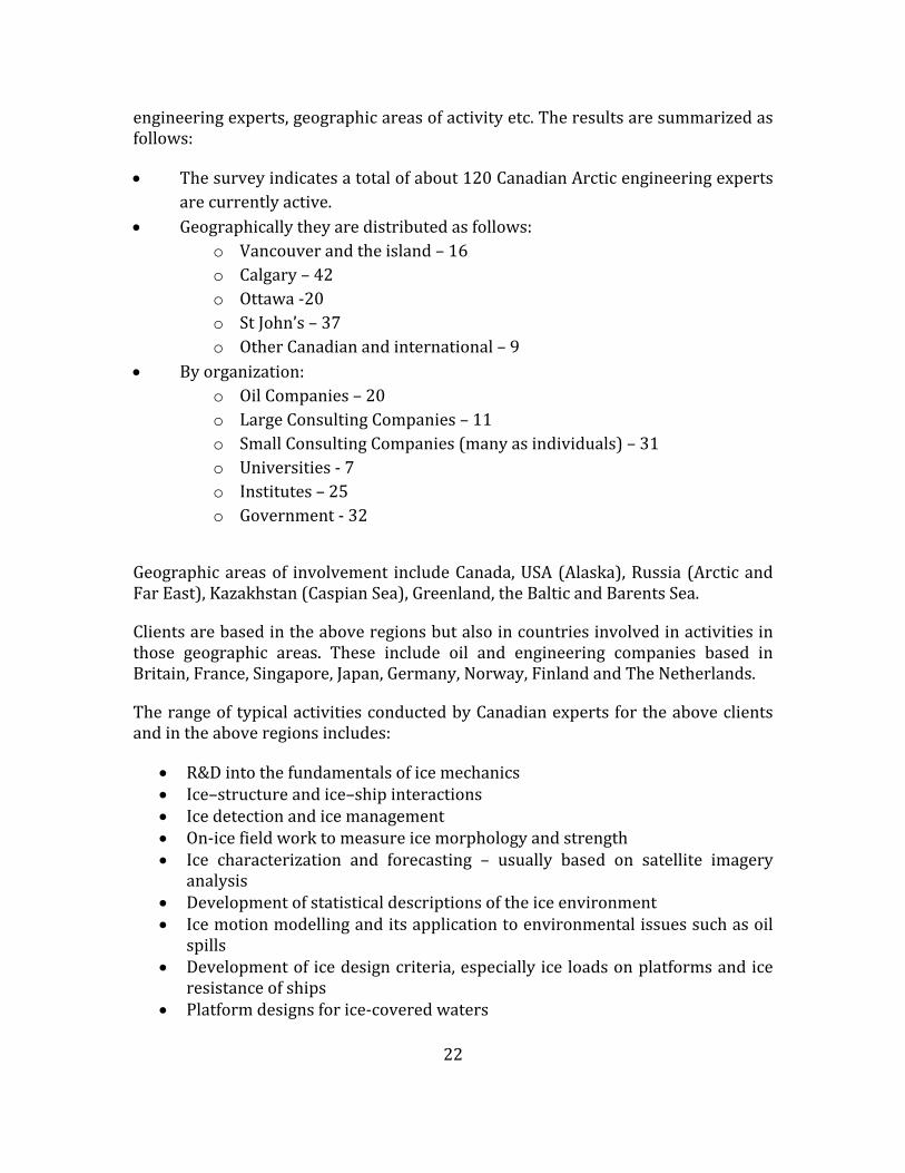
22
engineeringexperts,geographicareasofactivityetc.Theresultsaresummarizedasfollows:
Thesurveyindicatesatotalofabout120CanadianArcticengineeringexpertsarecurrentlyactive.
Geographicallytheyaredistributedasfollows:o Vancouverandtheisland–16o Calgary–42o Ottawa‐20o StJohn’s–37o OtherCanadianandinternational–9
Byorganization:o OilCompanies–20o LargeConsultingCompanies–11o SmallConsultingCompanies(manyasindividuals)–31o Universities‐7o Institutes–25o Government‐32
Geographicareasof involvement includeCanada,USA(Alaska),Russia (ArcticandFarEast),Kazakhstan(CaspianSea),Greenland,theBalticandBarentsSea.
Clientsarebasedintheaboveregionsbutalsoincountriesinvolvedinactivitiesinthose geographic areas. These include oil and engineering companies based inBritain,France,Singapore,Japan,Germany,Norway,FinlandandTheNetherlands.
TherangeoftypicalactivitiesconductedbyCanadianexpertsfortheaboveclientsandintheaboveregionsincludes:
R&Dintothefundamentalsoficemechanics Ice–structureandice–shipinteractions Icedetectionandicemanagement On‐icefieldworktomeasureicemorphologyandstrength Ice characterization and forecasting – usually based on satellite imagery
analysis Developmentofstatisticaldescriptionsoftheiceenvironment Icemotionmodellinganditsapplicationtoenvironmentalissuessuchasoil
spills Developmentoficedesigncriteria,especiallyiceloadsonplatformsandice
resistanceofships Platformdesignsforice‐coveredwaters

23
Logistics and operations in ice‐covered waters including escape andevacuation
Icemodeltankexperimentstoaidintheabovetopics Iceroadsandiceplatforms Icedesigncriteriaforoffshorepipelines,especiallyburialdepthstoavoidice
gougingoftheseafloor Trainingonicetopics,includingcoursestoindustrypersonnel Leadership and contributions to development of International Codes and
Standards
ItshouldalsobenotedthatthecontributionsofCanadianexpertsareoftenhiddenwithin larger project activities by either major oil companies or large EPCcontractors. These organizations often seek out Canadian experts (even inpreferencetodomesticexpertswithinthecountryofactivity);inouropinionthisisareflectionofthehighlevelofcompetenceachievedbyCanadianexperts.
The surveydidnotattempt toputaprecisevalueon thiswork,butdirect annualrevenuesby thesespecialistsand theirorganizationsareestimated tobebetween20 and 30 million dollars. Much of this can be classed as R&D, and is certainlyleadingedge,andmuchissupportedbyforeignincome.
One of the ongoing issues for Arctic Engineering is sustainability of expertise. Asdiscussed, many experts developed their skills commencing with the surge ofactivityintheCanadianBeaufortSeaandtheGrandBanksinthe1970sand1980s.Most are close to or beyond retirement age. Few universities specialize in Arcticoffshoretopics;infactcurrentlyonlyMemorialUniversityhasasustainedprogram.Over the past decade the number of universities conducting Arctic engineeringresearchandtraininghasdecreased.
DespitethedownturninCanadianArcticactivitiesduetovariousfactorsincludingoil prices and small discoveries, a critical mass of expertise survived and hasprosperedtotheextentthatitisrecognizedandsoughtafterworld‐wide.Canadianprojects such as East Coast oil development and the Confederation Bridge werehelpfulinsustainingtheexpertiseandinvolvingyoungerCanadianengineers,butitwould have shrunk considerably had not Canadians been able to successfullycompete internationally, as demonstrated in the case histories reported in thisstudy.TheenthusiasmandvisionforCanada’sNorthwhichprevailedinthe1970sdidleadtotheexpansionofNationalResearchCouncil(NRC)Arcticactivitiesandtothe establishment of centres of expertise such as C‐CORE. These can play a vitalfuture role. As younger engineers enter the field, it is the responsibility ofexperiencedengineers toprovidementorship tomeet thechallengesof sustainingandenhancingfutureCanadianexpertise.Goingforward,theminimal involvementofFirstNationsinworktodatealsoneedstobeaddressed.

24
2.4InventoryofCanadianCentresOrientedtowardsNorthernResearch
Inadditiontothesurveyofindividualexpertise,aninventoryofagenciesconductingorsupportingR&DrelatedtoCanada’sNorthernOceanshasbeenconductedusingtheprojectteam’sknowledgeandcontacts.Mostcurrentandrecentresearchiswelldocumentedandsearchableontheinternet.Thereisanextensivebodyofolderandstillrelevantresearchthatisnotaccessibleovertheinternet.Thefollowingprovidesasummarystatement;completedetailsarefoundinAppendixD.
2.4.1ArcticNet
ArcticNet is a Network of Centres of Excellence of Canada that brings togetherscientistsandmanagersinthenatural,humanhealthandsocialscienceswiththeirpartners from Inuit organizations, Northern communities, federal and provincialagencies and the private sector. Under the leadership of Université Laval andUniversityofManitoba,universitiesandagenciesfromacrossCanadaareengagedinavarietyofprojectsintheareasoftheimpactofclimatechangeandmodernization.The projects are largely science oriented but can provide useful backgroundinformationforengineeringapplications.
2.4.2CentrefortheNorth(CFN)
TheCentrefortheNorthisaninitiativeoftheConferenceBoardofCanada.Thegoalis tobringAboriginal leaders,businesses,governments,andcommunityadvocatestogether to identify challenges and opportunities, and to decide how thosechallenges can be met. They have completed a number of relevant reports, inparticular a recent one on economic development in Canada’s northern marinewaters.InadditionitispotentiallyagoodforumfordialoguewithNortherners.
2.4.3CanadianPolarCommission(GovernmentofCanada)
TheCanadianPolarCommissionhasresponsibility for:monitoring,promotinganddisseminatingknowledgeofthepolarregions;contributingtopublicawarenessoftheimportanceofpolarsciencetoCanada;enhancingCanada'sinternationalprofileas a circumpolar nation; and recommending polar science policy direction togovernment. It is a valuable source of background information for engineeringstudies.
2.4.4CanadianHighArcticResearchStation(CHARS)
TheCanadianHighArcticResearchStation(CHARS)willprovideaworld‐classhubfor science and technology in Canada's North that complements and anchors thenetworkofsmallerregionalfacilitiesacrosstheNorth.Thenewstationwillprovidea suite of services for science and technology in Canada's North including atechnology development centre, traditional knowledge centre, and advancedlaboratories. CHARS is located in Cambridge Bay, Nunavut. Its present focus israther broad. The research program being developed is science oriented, with a

25
place for engineering application. CHARS represents a potential location for aNortherneducationalinstitution.
2.4.5C‐CORE,LOOKNorth&CARD(centreswithinC‐CORE)
C‐CORE addresses challenges facing oil and gas development offshoreNewfoundland and Labrador and other ice‐prone regions. C‐CORE is a multi‐disciplinary organization with world‐leadingcapability in Remote Sensing, IceEngineeringandGeotechnicalEngineering.HeadquarteredinSt John'sNL,C‐COREmaintains a close collaborative relationship with Memorial University. C‐CORE isalso home to LOOKNorth, a Canadian Centre of Excellence for remote sensinginnovation to support northern resource development, and the Centre for ArcticResourceDevelopment(CARD),aninitiativeincollaborationwithindustry,focusingon medium‐ to long‐term Arctic research and development.C‐CORE is a strongengineeringconsultancywithanextensiveknowledgebase.
2.4.6CanadianNetworkofNorthernResearchOperators
The Canadian Network of Northern Research Operators (CNNRO) facilitatescollaborationandtheexchangeofinformationamongallstakeholderswhoshareaninterest in infrastructure and logistics to support research in Northern Canada.Potentiallycouldassistinprovidinglogisticsupportforfieldwork.
2.4.7ArcticInstituteofNorthAmerica(atUniversityofCalgary)
TheArcticInstituteofNorthAmericaisamulti‐disciplinaryresearchinstituteoftheUniversityofCalgary.Theinstitute'smandate istoadvancethestudyoftheNorthAmericanand circumpolarArctic through thenatural and social sciences, theartsandhumanitiesandtoacquire,preserveanddisseminate informationonphysical,environmental and social conditions in theNorth. It isa great storeofdocumentsandstudiesfocusedonenvironmental,socialscienceandengineeringissues.
2.4.8NRCArcticProgram
This research program includes thrusts on resource development, northerntransportation,marinesafetytechnologyandcommunityinfrastructure.NRChasalonghistoryofnorthernengineeringresearchextendingbackover60yearsandisastrongrepositoryofArcticengineeringknowledgeandexpertise.
2.4.9ProgramofEnergyResearchandDevelopment(PERD)
The Program of Energy Research and Development (PERD) is a federal,interdepartmentalprogramoperatedbyNaturalResourcesCanada(NRCan).PERDfundsresearchanddevelopmentdesignedtoensureasustainableenergyfutureforCanadainthebestinterestsofbothoureconomyandourenvironment.Itincludesprograms on offshore environmental factors, northern regulations, marinetransportation and environmental impacts. Results of projects contributeengineeringknowledgeofArcticoffshore.

26
2.4.10PolarContinentalShelfProgram(PCSP)
The PCSP coordinates field logistics in support of advancing scientific knowledgeand management of Canada’s lands and natural resources. As a national servicedelivery organization, PCSP coordinates logistics for federal, provincial andterritorial government agencies, northern organizations, universities andindependentgroupsconductingresearchinCanada’sNorth.Theprogramprovidesgoodlogisticssupporttoengineeringresearchfieldwork.
2.4.11BeaufortRegionalEnvironmentAssessment(BREA)2011‐14
BREA isa fouryear(2011to2015)multi‐stakeholder initiative that issponsoringregional environmental and socio‐economic research to assist in preparing allparties,includingthefederalgovernmentandlocalcommunities,torespondtonewinvestments in oil and gas in the Beaufort Sea. Results of some projects haveengineeringapplication.
2.4.12EnvironmentalStudiesResearchFunds(ESRF),CAPPsupported
ESRFisaresearchprogramwhichsponsorsenvironmentalandsocialstudies.It isdesignedtoassistinthedecision‐makingprocessrelatedtooilandgasexplorationand development on Canada's frontier lands. The ESRF is directed by a jointgovernment/industry/public Management Board. Results of many projects haveengineeringapplication.
2.4.13CanadianInternationalCentrefortheArcticRegion
AspartofCanada'sArcticforeignpolicy,adedicatedCanadianInternationalCentrefor the Arctic Region (CICAR) was established in 2009. CICAR is located in theCanadian Embassy in Oslo, Norway and has a network of officers at Canada’sembassies inNorthAmerica,EuropeandAsia. ThisCentrecouldprovide linkagesbetweenCanadianengineersandinternationalpartners.
2.4.14IndustryandConsultants
The survey summarized in Section 2.3.2 indicated that of the approximately 120Arctic offshore engineers currently active, about half (60) are working withinindustryorasconsultants.Thereabout20employed(orundercontract)fulltimeintheoilindustry.
MostoftheseareassociatedwiththeChevronArcticCentre,whichcurrentlyistheonly dedicated oil industry Arctic group in Canada. To quote from the Chevronwebsite “itishometosomeoftheworld’sforemostexpertsinArcticexplorationanddevelopment.TheCenterconsistsofacoregroupofArcticsubjectmatterexpertswhosupport Arctic exploration, asset development and business development projectsacross the Chevron global upstream. The group has expertise in the followingdisciplines:

27
Regulatory&Policy Environment Seismic Drilling Facilities IceEngineering Structures Marine NavalArchitecture Logistics Development”
OthermajoroilcompanieswithArcticinterestshavesimilargroups,butarelocatedmostlyintheUSA.Often,theywilluseCanadianconsultantstobolstertheirwork;infact,manyCanadianArcticengineeringspecialistsspendthemajorityoftheirtimeworkingforsuchforeignentities.
Some of the larger global EDC contractors also employ Arctic engineers in theirCanadianoffices.Oursurveyindicatedabout10Arcticspecialistsemployedbythiscategory. Companies includeAusenco (whohad previously bought out Sandwell ‐whohadpreviouslyacquiredSwanWooster)andWorleyParsons.
OtherCanadianconsultants(about30inoursurvey)tendtobeindividualsorthoseemployed by small consulting entities or small specialists group within largerCanadian consulting companies. Individuals are not named here, butsmall/specialized companies include: AKAC; Canatec Consultants; GolderAssociates;BMTFleetTechnology;TetraTechEBAandBerchaAssociates.
2.5ReviewofRecentReports
ManyoftheorganizationslistedinSection2.4conductfocusedreviewsofnorthernissuesandproducereports. Inconducting thisstudy, relevantrecentreportshavebeen reviewed. They provide useful background and specialized inputs andperspectives. This review was also thought necessary to avoid duplication. Asummary is provided here to indicate their scope, and key conclusions whereappropriate.Thosemostrelevanttothisstudyaregivenmorespace.ThefullreviewisprovidedinAppendixE.
2.5.1 Centre for theNorth (CFN) ChangingTides: EconomicDevelopment inCanada’sNorthernMarineWaters(Fournier,S.andCaron‐Vuotari,M.,2013)
ThereportemphasizesthatCanada’snorthernmarinewatersrepresentoneoftheworld’s last natural resource frontiers. Development will hinge on four factors:climate change, infrastructure, emergency response and search‐and‐rescue (SAR),andcommodityprices.ItsummarizesrenewedinterestinoilandgasexplorationintheBeaufortSea,andrecentoffshorelicensesindeeperwatersinBeaufortSea.

28
Thereportdiscussesclimatechangeanditspossibleeffectsonaccessbothmarineandoverland.ItemphasizesthattheonlydeepwaterportintheArcticatpresentisat Churchill,Manitoba.One is plannedby theCanadian government forNanisivik,Nunavut,expandingthefacilitydevelopedfortheNanisivikmine.SARfacilitiesanddisasterresponsecapabilityareseentobeinadequate.
Development of industry and commercial enterprises can be a driver for thedevelopment of facilities. A boom‐and‐bust issue is associatedwith this: facilitiescan be built for a particular development, used, and then not retained (or not besuitable)forcommunityuse.
The report gives examples of approved and plausible projects in Canada’s North,thoserelatingtotheoceansinclude:
aGovernmentofCanada investment in a refuelling anddocking station formilitary and coastguard vessels (although originally intended as a moreexpansivedeepwaterportfacility)atNanisivik;
a possible private sector investment in a deepwater port and road at theheadofBathurstInlet,Nunavutforminingoperations(zincandgold)intheregion;and
apotentialexpandedrole for thePortofChurchill throughtheprovisionofservicestocommunitiesandminingoperationsalongtheKivalliqcoastandinmeetingfreightdemandsforNunavutingeneral.
The report comments on the need for collaboration in decision making andgovernance; leveraging of private and public sector resources; addressinguncertainties; risk management; and that “Theway that the risks and benefits ofeconomicdevelopmentareweightedandmanagedmustmake sense toNortherners,keeptheirinterestsfrontandcentre,andeffectivelycapturetheNortherncontext.”
2.5.2 CFN Northern Assets: Transportation Infrastructure in RemoteCommunities(Bristow,M.andGill,V.,2011)
Ageneralpointismadethattransportationinfrastructureinnortherncommunitiesis significantly more expensive to develop than in the south. TransportationinfrastructureinCanada’sNorthissparse.
Again, the effects of climate change are discussed, with its effects on roads andaccess.
Marinetransportofferstheleastexpensivetransportationmethodforfreightandisusedfortransportingfuel,groceriesandothercommercialfreighttotheNorthwestTerritories,Nunavut,andthenorthernregionsofprovinceswithtidewateraccess.Atthesametime,thereisverylittlemarineinfrastructureintheNorth,andalmost

29
noneinNunavut.Cargoisoftenoffloadedontobeaches,andaccesstotheselandingsitescanbeunpredictable.Themarineshippingseasonisshort,rangingfromonetofivemonths,dependingonthelocationofthecommunity.
ThereportconsidersacasestudyofChurchill,Manitoba.Thisportisnotconnectedto the road system in northern Manitoba, but has access to air, rail and marinetransportation,airandrailbeingavailableyear‐round.ChurchillisalsothehometotheonlyoperatingdeepwaterportintheArcticregion,makingitapossibleshippinghubforthefarNorth.AnumberofkeyissuesintheChurchillcasestudyprovidedbackgroundfordevelopmentinothernortherncommunities.
2.5.3CFNFutureofMining
Theresultsof thestudysuggestkeyareas forpolicy recommendations to supportfuturesustainableminingdevelopmentinCanada’sNorth:
acompetitivebusinessenvironmentfortheminingindustry; addressinginfrastructuregapsandneeds; recruitment initiatives aimed at women, new Canadians, youth and
Aboriginalworkers; meaningful community consultations and ensuring the implementation of
Aboriginallandclaimsandresourcedevelopmentagreements; improving regulatory processes and personnel turnover in government
regulatorybodies;and furtherinvestmentsingeoscience.
ThisreportisreviewedindetailinAppendixE.
2.5.4CCANorthernOceanScience inCanada:Meeting theChallenge,SeizingtheOpportunity
Recognizing the importance of ocean science, the Canadian Consortium of OceanResearchUniversities(CCORU)asked theCouncilofCanadianAcademies (CCA) toundertake an assessment of the state of ocean science in Canada. The reportwascarried out by an expert panel formed by the Council of Canadian Academies(CouncilofCanadianAcademies,2013).
Canada’sexisting researchcapacitywas investigated.ThestateofCanada’sageingresearchfleetwasnoted.Canada’soutputofoceansciencewasconsideredtobeinthetoprankatpresent,butatrisk.Fundingopportunities,forinstancethoseofferedby the Canada Foundation for Innovation, are enabling the establishment andmanagement of large‐scale infrastructure. This includes vessels and observationnetworks.ConsortiasuchasCCORU,areemerging.Thesenetworksandalignmentshave resulted in several innovative, world‐leading initiatives. Despite theseadvances, the Panel identified the gaps in the coordination and alignment of the

30
ocean science community in Canada. Theseprincipally relate to lack of a nationalvision for ocean science and lack of effective national‐level mechanisms toco‐ordinate resources and sharing of infrastructure and knowledge among oceanscientists.
2.5.5 True North: Adapting Infrastructure to Climate Change in NorthernCanada
Thisreportwascarriedoutby theNationalRoundTableon theEnvironmentandtheEconomy(2009).
By means of research and extensive consultation with stakeholders, the risks tonorthern infrastructure posed by climate change were investigated, along withopportunities for adaptation. The recommendations were primarily addressed togovernment and were focused on adaptation to climate change and the use ofcurrent and future policy and decision‐making processes to this end. Buildingnortherncapacitytoadapttoclimatechangewasaprimemotivation.
2.5.6ArcticMarineShippingAssessment(AMSA)2009(ArcticCouncil)
TheArcticCouncil in2004commissionedaworkinggroup toprepare the subjectreport.Thereportdealswithclimatechange,Arcticmarinetransport,governanceofArctic shipping, current marine use, future scenarios, human and environmentalconsiderations, and infrastructure. Natural resource development (hydrocarbons,hard minerals and fisheries) and regional trade were seen as the key drivers offuture Arctic marine activity. A lack of major ports, except for those in northernNorway and northwest Russia, and other critical infrastructure poses significantdifficulties for future Arctic marine operations. Destinational shipping isemphasized.ManyArcticresidentsdependonmarineresourcesforsubsistenceanditissuggestedthatconstructiveandearlyengagementoflocalresidentsinplannedArcticmarinedevelopmentprojectswillbebeneficialtotheirwell‐being.
Thereportiscommendableintermsoftherangeandthoroughnessofitscoverage.RecommendationsweremadeonArcticmarinesafety,protectionofArcticpeopleand the environment, and building Arctic marine infrastructure. Of particularinterest are that the Arctic states should support the development andimplementationofacomprehensive,multi‐nationalArcticSARinstrument,andthatthe Arctic states should cooperate in the development of Arctic marineinfrastructure.
2.5.7FromImpactstoAdaptation:CanadainaChangingClimate2007
ThisreportwassponsoredbyNaturalResourcesCanadaandEnvironmentCanada(Lemmen et al., 2008). Its focus is on changing climate and adaptation to thischange. The report points out that adaptive capacity in Canada is high, but thatresource‐dependent and Aboriginal communities are particularly vulnerable toclimatechanges.ThisvulnerabilityismagnifiedintheArctic.
31
2.5.8ThePastisAlwaysPresent:ReviewofOffshoreDrillingintheCanadianArctic(NationalEnergyBoard,2011)
Thesame‐seasonreliefwellissueiscovered.Regardingthismatter,NEBaffirmeditsintent to retain its same‐season relief well policy. The report also included thestatement that “an applicant wishing to depart from our policy would havetodemonstratehowtheywouldmeetorexceedtheintendedoutcomeofourpolicy.Itwould be up to usto determine, on a case‐by‐case basis, which tools areappropriate.... We acknowledge that there is a continual evolution of technologyworldwide, including the technologyneeded to kill an out‐of‐controlwell.We areopentochangingandevolvingtechnology.”
2.5.9CARDArcticDevelopmentRoadmap(CARD,2012)
Thereportisfocusedontheoilandgasindustries.Aspartofitsplanningprocess,the Centre for Arctic Resource Development (CARD) developed the “ArcticDevelopment Roadmap” (CARD, 2012). The importance of this document for thepresentCAEstudy is that, inorder todevelop theroadmap,aseriesof interviewswereconductedwiththemajoroilandgasoperatorsandconsultantsinordertogettheir perspectives. The oil and gas operators who were interviewed includedExxonMobil, Suncor, Husky Energy, Statoil, Chevron, Imperial Oil, Shell andConocoPhillips.AppendixFlistspastplanningstudiesofrelevancetotheCanadianArctic.

32
3FutureOpportunitiesandChallenges
3.1Overview
FutureopportunitiesforCanadainitsNorthernOceansarevariedandchallenging.Examples include: development of mineral resources; increased tourism; newfisheries; creationofprotectedareas; improvements innorthern settlementsandthe livesofNortherners;enhancedmarinesystems(bothyear‐roundshippingandports)tosupporttheseactivities;andenhancingsovereignty.
Thereareissuesrelatingtotheabovewhicharebroaderthanengineering,yettheengineeringtosupportandenablefutureopportunitieswillbecrucial,andthiswillbeourfocus.
3.2InventoryofMineralResources
Afirststep indevelopmentofresources is toknowwhat is there.TheknownandpotentialenergyandmineralresourcesoftheNorthareextensive. Itisavastandremote area, covering about 40% of Canada’s land area plus significant offshoreareas,andstillonlypartiallyexplored. SomeofthenaturalresourcesoftheNorthhave been identified and a subset of them has been or is being exploited, butundoubtedlymanyremaintobediscovered.Energyandmineralresourcesforthepurpose of this review include hydrocarbons, metals and other minerals.Hydrocarbonsaregenerallyinliquidorgaseousform,butcanalsoincludesolids–coal,forexample.Petroleumandnaturalgasarefoundbothonshoreandoffshore,and currently, while the offshore is attracting themost interest, there is ongoingexplorationandproductionofoilandgasfromonshoreareas.Mineralsincludebasemetalssuchasiron,copper,zinc,nickelandotherores,preciousmetalssuchasgoldand diamonds, and otherminerals such as ‘rare earths’. Some of these resourceshavebeenknownforsometime;NormanWellsoilandYellowknifegoldhavelongproductionhistories,andtheMaryRiverironoredeposithasbeenknownforover50years.
Identifying potential resource deposits involves both government and industryefforts. There is an ongoing program within the Government of Canada forgeologicalmappingofenergyandmineralresourcesintheNorth1.Theknowledgefrom this program will advance geological knowledge in the North to supportincreased exploration of natural resources and inform decisions on land use thatbalance conservation and responsible resource development. Seismic surveysconductedby industry, offshore andonshore are aimedat identifyingprospectivehydrocarbondeposits.
1 https://www.nrcan.gc.ca/earth‐sciences/resources/federal‐programs/geomapping‐energy‐minerals/10904

33
SeeAppendixIforMineralsMap.
3.2.1Hydrocarbons
AccordingtotheNationalEnergyBoard,approximately35%ofCanada’sremainingmarketableresourcesofnaturalgasand37%ofremainingrecoverablelightcrudeoil is in northern Canada (Canada’s Energy Futures, 2011). These percentagesreflectconventionaloilandgasresourcesonlyandareexclusiveofunconventionalresources.(AANDC,2013)
Figure3.1:BeaufortSeaLeases(AANDC,2014)
Regional estimates of Canada’s northern discovered resources are listed inAppendixG.Thetotalsforconventionaloilandgasresourcesindiscoveredfieldsis1.2billionbarrelsofoil and30 trillioncubic feet (TCF)ofgas, anddonot includeestimatesofpotential inundrilledprospectsandbasins.Ultimatepotential (whichincludesdiscoveredresourcesandundiscoveredpotential)isestimatedatabout12billionbarrelsofoilrecoverableand150TCFofgas,butmuchuncertaintyremainsabout the resource potential in many of Canada’s northern petroleum basins,especiallythosewhichhaveyettobetested.
Recentstudiesindicatethatanupwardsrevisionofestimatesofultimatepotentialmay be warranted. For example, a review of new information by the GeologicalSurvey of Canada suggests that undiscovered resources in the Beaufort Sea –MackenzieDeltaBasincouldmorethandoublewhenextensivedeepwaterpotential

34
is included. Thus the discovered resources only represent a small fraction of thepotential.
Unconventional hydrocarbons are attracting oil and gas industry attention in theMackenzieValley.Thesepotentialresourcesincludeshalegasandshaleoilinsourcerock known to have generated the oil at Norman Wells. These unconventionalresourcesintheMackenzieValleyhavenotbeenincludedinthepotential,butmakeasignificantaddition.
3.2.2Minerals
Themineral resourcesof theNorth represent a significantpotential for economicdevelopmentoverthenextdecade(CFN,2013). Historically,preciousmetalshavebeenadriver, fromtheYukongoldrushat theendof the19thcentury tothegoldmining in Yellowknife. Later, strategic minerals like radium and uranium wereminedatPortRadium.TheGeologicalSurveyofCanadahasovertheyearsprovidedgeologicalinformationwhichhasgreatlyaidedmineralexploration.Goingfromthisgeneral geological information to mineral prospects, discoveries, projects andeventuallyproductionisalongchain.Thestartoftheprocess,prospectingisakintofindinganeedle inahaystack. Thousandsofpotential sitesaresubject tosurfacesurveys, prospecting, sampling and assessing before even a claim can be made.Surface shows need further evaluation to see if they are prospects that couldeventually be projects. In 2012 almost half a billion dollars was spent onexploration in the North (CMA, 2013, Facts and Figures). There is a greatwinnowing‐downprocesstowhateventuallymaybecomeaproducingmine.
Currently there are a small number of actual producing mines in the North. Tonumber some of them: there is one producing gold mine in Nunavut, threeproducing diamond mines in the Northwest Territories and two precious metalminesintheYukon.ThetotalvalueofmineralproductionintheNorthisnowabout3billiondollars;almosta3foldincreaseoverthelastdecade.Thisisalmost10%ofthevalueofthetotalmineralproductionforCanada.ThevaluesfortheNorthwestTerritories, Nunavut and Yukon are $1.7, $0.6 and $0.5 billion, respectively,representingsignificantcontributionstoeconomicactivityintheNorth.Foreachoftheseproducingdevelopments there aremanymoreprojectsunderdevelopment.For example, there are approximately 10 projects under development in each ofNunavut and the Northwest Territories. A listing of these for Nunavut and theNorthwestTerritoriesisincludedinAppendixH.Miningoperationsareasignificantemployer.TheMeadowbankGoldMineinNunavutemploysabout450people.Totalpotential mining employment in Nunavut could reach 5000. In the NorthwestTerritories,withamorematureminingindustry,employmentstandsatabout3000withaboutanother2000associatedwithdevelopingprojects.

35
3.2.3Constraints
Itshouldberememberedallminesandhydrocarbondevelopmentshaveafinitelife.Forexample,theComincolead‐zincmineatLittleCornwallishadalifeofabout20yearsandthelead‐zincmineatNanisivik,25years.Bothminesareclosedandthesites have been reclaimed. This finite life has an impact on the infrastructuredevelopedfortheproject,wheredecommissioningisalsoexpected.
Whilethereisgreatpotentialforresourcedevelopment,therearemanyfactorsthatdeterminewhetheraresourcecanbedeveloped:
• worldpriceforcommodity,• accesstotransportation,• logisticssupport,• environmentalimpactassessment,• localsocio‐economicfactors(localacceptance),• availabilityofskilledworkforce,and• availabilityoffinancing.
Thus,identifyingthepresenceofaresourceisjustasmallpartofthechaintowardspossibledevelopment.Engineeringandtechnologycanpositivelyinfluencesomeofthesefactors.
3.3DevelopmentScenariosandChallenges
3.3.1Hydrocarbons
The primary driver for oil and gas development is the presence of oil and gas insufficient quantities to be economic. If the geology of an area is consideredappropriate, geophysical surveys identify potential “structures” in whichhydrocarbonsmaybepresent.Thesehavetobedrilledintotoconfirmhydrocarbonpresence (or otherwise). Based on the results of this process in the past fewdecades,thereareknowndepositsofoilandgasinCanada’sArcticoffshorewhichas yet are undeveloped. In other areas, geological assessments and somegeophysicalworkareunderwaybutdrillinghasnotyetoccurred.Therefore,wecandividefuturesscenariosintotwocategories:
1. Where prior drilling has occurred and significant discoveries have beenidentified,butnodevelopmenthasyetoccurred.
2. Areaswithpromisinggeology,butnoexploratorydrillinghasyetbeendone.
3.3.1.1Developmentofexistingdiscoveries
SignificanthydrocarbondiscoveriesexistintheBeaufortSea,offshoreLabradorandintheArcticArchipelago.IntheBeaufortSea,asaresultofthedrillingintheperiod1970to1992,thetotalofallsignificantdiscoveriesisabout1.2billionbarrelsofoil

36
andabout10TCFofnaturalgas.ThelargestdepositisAmauligak,inabout30mofwater. It contains about 300million barrels of recoverable oil. A field this size inotherpartsof theworldwith existing infrastructure andno icewould likelyhavealreadybeendeveloped.ForAmauligaktobedeveloped,atransportationsystemfortheproductsiskey.Thiscouldbeapipelinesouthortheuseoficebreakingtankers.Either systemwould potentially create an infrastructure thatwould enable othersmaller fields in the Canadian Beaufort also to be developed, as well as futurediscoveries.
AnotherregionwithsignificantdiscoveriesisoffshoreLabrador.Inthiscase,naturalgas discoveries total 4.2 TCF. Thewater depths of the discoveries are 100m anddeeper. The key challenges are that natural gas prices have been low and otherlower‐costsourcesofnaturalgasareavailable.Ifnaturalgasrisesinprice(to,say,the oil price equivalent perBritish thermal unit (BTU), themotivation to developcouldbecreated.Then, the technicalchallengesrelate to icebergsandsea ice– inparticular, platform design to resist more frequent icebergs than on the GrandBanks,andpipelinedesignandinstallationtogetthegastoshoreortoincorporatea floating LNG plant. This scenario is identified in the CARD Arctic DevelopmentRoadmap(Section2.5.9).
Natural gaswas discovered by Panarctic Oil in the CanadianArctic Islands in the1970s.TheHeclaandDrakefieldsareonMelvilleandKingChristianIslandsandthewaters offshore. The fields have an estimated 5.7 TCF of proven and 20 TCF ofprobable recoverable reserves. In 1978 an experimental gas pipeline was laidbetweentheDrakeF‐76wellheadin55mofwaterandtheshoreofMelvilleIsland,adistance of 1100m. The Arctic Pilot project in the early 1980s investigated thepossibilityofanLNGfacilityonMelvilleIslandwithice‐breakingLNGtankerstakingtheproducttoEurope.Thisisstillapossiblefuturescenario,butcurrentlytherearecheaper sourcesof natural gas around theworld.Thekey technological challengerelatestobuildingandoperatinganLNGplantintheHighArcticandthenthedesignandoperationoficebreakingLNGtankers.
There are also oil discoveries in the Canadian Arctic Islands: Bent Horn N‐72 onCameron Island andCisco, offshorenearLougheed Island. TheBentHorn field issmall,at16millionbarrels,butwasthesiteofseasonalcommercialproductionwithabout 3million barrels being shipped south by theMV Arctic between 1985 and1996.Ciscoisamuchlargerfieldatabout600millionbarrels,butbeingoffshoreinthe Canadian Arctic Archipelago, it is unlikely to be developed with presenttechnology.
3.3.1.2Scenariosforfuturediscoveriesinice‐coveredregions
The main interest of the present study lies in future oil and gas scenarios forCanada’s Arctic (including ice‐covered sub‐Arctic regions). World‐widedevelopmentsareoflessimportancebuthavesomerelevanceintermsoftheneed(and opportunities) for Canadian services and products. In addition, technology

37
developed for other Arctic regions may have application in Canada. Finally, anydevelopmentsintheArcticoffshoreinotherjurisdictionsmayaffectCanada’sArctic(e.g., transportation routes andpotential environmental effects). Therefore, in thelistingofscenariosfordevelopmentoffuturediscoveriesitisusefultoincludebothCanadaandtherestoftheworld,buttokeepthemseparate.Thelistsareasfollows.
ForCanada:
BeaufortSea(deeperwaterthanpriordiscoveriesmentionedabove) TheEastCoast(generally furthernorththancurrentproductionoperations
ontheGrandBanks) GulfofStLawrence
Worldwide:
KaraSea,LaptevSea,Russia USBeaufortSea ChukchiSea OffshoreGreenland BarentsSea,Russia Sea of Okhotsk (Further north and in deeper water than current Sakhalin
developments)
Itisofinteresttolookatqualitativedegreesofdifficultyassociatedwitharangeofworld‐wide Arctic developments which include some of the above. This wasincludedintheArcticDevelopmentRoadmap(basedonScott,2009)andisshownhereasFigure3.2,whichisaroughguide;waterdepthineachregionisalsoamajorfactor.

38
Figure3.2:RelativedegreeofdifficultyofvariousArcticoilandgasdevelopmentscenarios(CARD,2012)
3.3.1.3IssuesidentifiedrelatingtofutureArcticoilandgasscenarios
No future oil and gas developments will take place in the Arctic unless they areeconomic,andshouldonlytakeplacewithlowriskstopeopleandtheenvironment.These criteriawill be applied formally by the proponents and the regulators andperhapslessformally,butnolessstrongly,bysocietyingeneral.
In their survey of the industry and the regulators, CARD in their Arctic Roadmapsummarized and prioritized the key issues identified. It is useful to review theseresults before proceeding further. Figure 3.3 shows the issues/topic areasrepresentedasapyramidwiththemostcriticalatthetop.
Figure3.3:ExtractfromtheCARDArcticDevelopmentRoadmapstudyonkeytopicsforArcticoffshoreR&Dforoilandgasproduction(CARD,2012)

39
Wenowsummarizethetopicsnoted,followedbyadiscussion.
1. Environmental Protection: Regulatory approval is needed, together withemergency planning (in particular for oil spill prevention and response).Drilling of a same‐season relief well poses difficulties as operations movefurthernorth,withshorterdrillingseasonsandmoredifficulticeconditions.
2. IceManagement:Managementoficeisnecessaryforoperationstodealwithheavy ice conditions, and to extenddrilling seasons. Forecasting of ice andmetocean conditions is an important component in these operations,includingsuchfactorsassuddenchangesinthedirectionoficemovement.
3. Ice Mechanics and Loading: Local and global ice pressures are needed fordesign.Thescaleeffectismostimportantinglobaldesignandwouldbenefitsignificantlyfrommorefull‐scaletesting.Improvedinformationonforcesinpackiceisseenasaresearchneed,aswellasthemechanicsofinteractionofslopingstructureswithMYice.
4. Station‐keeping in Ice: Thiswas seenasaneed to extenddrilling seasons.Controlofoffsetsduringdrillingoperationsisanimportantfactor.Improvedmooringanddynamicpositioningsystemswereseenasdesignneeds.
5. Environmental Characterization: There is a need for improved informationon ice andmetocean conditions for real‐time operations and for design. Inthelattercase,statisticsoniceoccurrence,typesandthicknessesareneeded.Improved forecasting of Arctic ice conditions andweather were seen as afurtherneed.
Although the research directions suggested above are sensible and necessary foroperationsduringpart of the year, considerationmust alsobegiven to long‐termdevelopmentandproduction.Theconceptthatafloatingsystembedisconnectedingiveniceconditionsisquitefeasibleifbasedonaclearcondition–forexample,thepresenceofaniceberg.IntheHighArctic,withmulti‐yeariceofvaryingthickness,including ridges, and possible changes of drift direction, the criteria fordisconnection become difficult to define and operate. Year‐round floatingproductionasontheGrandBankswillbeaconsiderablechallengefortheBeaufortorLabradorSeas.Subsea installations,withpipelinestoshallowerwaterwith lesssevereice,maybeamorerobustapproach.Nevertheless,floatingsystemswithicetolerance combined with ice management will still be needed for drilling, wellservicingandcontingenciessuchasrelief‐welldrilling.
3.3.1.4Hydrocarbons‐Discussion
Ashasbeennotedalready,akeydriverofdevelopmentiseconomics.Developmentshave to deliver value for the range of expected future commodity prices. Currentnaturalgasandoilpriceswillmakemanypossibledevelopmentsdifficulttojustify

40
on these grounds. Nevertheless, it is generally anticipated that priceswill rise asworld supply and demand once more become balanced. Even so, these frontierresources are also competing with other supplies such as from the oil sands. Ifdevelopmentcostsaresimilar,otherissuessuchasGHGintensityofdevelopmentsandlocalbenefitswillalsoinfluencechoices.
3.3.2Minerals(Mining)
Asalreadydiscussed,theNorthhasgreatpotentialformineraldevelopment.Wheredevelopmentshavegoneahead,eitherthemineralwasprecious(forexample,goldordiamonds), strategic (such asuranium)orbulk (like lead‐zincornickel). In allcases,theoreconcentrationhadtobeveryhightomaketheoperationviableduetotheextracostsimposedbyremoteness.
Future scenarios will largely involve onshore mines. Many of these will seektidewater as a transportation route for their products; hence, their relevance toNorthernOceans.
The precedents for shipping ores by icebreaking vessels have already beenmadeanddiscussedinSection2; these includeNanisivikonBaffinIslandandPolarisonLittle Cornwallis Island. In these cases, the concentrate was stored through thewinter, then shipped seasonally (although the vessels still required significant icecapabilities).FurthersouthattheVoisey’sBayminedevelopmentontheLabradorcoast,year‐roundshipping isemployed.The icebreakingbulkcarrierUmiak1wasdesignedandbuiltforthistrade.
It can be expected that future developments will strive to extend the shippingseasonaslongaseconomicallypossible.Thisleadstothechallengeofmoreefficienticebreaking vessels, aswell as the operation of year‐round ports and newwinternavigable routes to markets. These challenges are discussed further under theheadingsof“Shipping”and“Infrastructure”.
Mining,millingandconcentratingrequireconsiderableamountsofenergy.Attheseremotesitesanyformofenergyisexpensive. Processesthatcanminimizeenergyrequirementswouldgreatlybenefitnorthernminingdevelopments.Theavailabilityof alternative energy sources that do not require long and expensive shipping isdesirable. Windpowerhasbeenusedtoreduce importedenergyrequirementsatone site. The high costs associated with providing northern mining energyrequirementsmayinfactprovideabetteropportunityforalternativeforms.Theuseof localLNG isanotherpossibilityand ismentionedagain later in thecontextofa“greenfuel”fortheNorth.

41
3.4ShipsandShipping
3.4.1EarlyBeginnings
MarinecrafthavebeenusedtosuccessfullynavigatethewatersofnorthernCanadaformillennia.Craftsuchasumiaksandkayakshavebeenbuiltfromlocallyavailablematerialsandused forhuntingand transport. Theseboats,builtusing traditionalknowledge,areelegantexamplesofindigenousdesignandengineering.
3.4.2TheNorthWestPassage
Exploration for the fabled Northwest Passage as an alternative route from theAtlantic to thePacificwascarriedoutoverseveralcenturiesafterPopeAlexanderVI, inthetreatyofTordesillasof1494,dividedtheNewWorldbetweenSpainandPortugal and thus blocked access to China and the Spice Islands by northernEuropeancountriessuchasGreatBritainandtheNetherlands.
The actual existence of the Passage, however, was not confirmed until the 19thcentury,whenitwastransitedinmulti‐yeartripsbyMcClure(byshipandsled)andby Amundsen (by ship). It was not until 1944, that the Canadian‐built RCMPschoonerStRochmade the first continuousvoyage through theNWPassage fromHalifaxtoVancouverin86days,underthecommandofSargentHenryLarsen.
Inthe1960soilwasdiscoveredonthenorthslopeofAlaskaandaboldexperimentwas undertaken by Humble Oil (now ExxonMobil) to ascertain the feasibility ofusing icebreaking tankers to bring oil fromAlaska to the east coast of theUnitedStates,usingtheNorthwestPassage. Thecompanyconvertedthelargesttankerinthe US fleet, the SSManhattan, into an icebreaking vessel and in 1969, with theCanadianCoastGuardicebreakerJohnAMacDonaldinattendance(Figure3.4),shemade a successful transit through the Passage to Alaska and back again. Thisactivity, although it demonstrated the potential for commercial ship voyages innorthernwaters,didnotresultinoilbeingexportedfromAlaskainthismanner.

42
Figure3.4:SSManhattanandCCGSJohnA.MacDonaldinNWPassage–1969(Photo:Capt.JosephOsifat)
In fact, it is only in very recent times that any commercial cargoes have beentransported through the Northwest Passage by sea‐going cargo ships unaided byescorting icebreakers. The Canadian‐owned icebreaking bulk carrierMVNunavik(Figure3.5) loadeda cargoofnickel oreatCanadianRoyaltiesnear the tipof theUngava peninsula inHudson Strait and sailed north on September 19, 2014. ShereachedtheBeaufortSeaonSeptember28thandpassedthroughtheBeringStraitsenrouteforChinaonOctober1st.
Figure3.5:25,000tondeadweighticebreakingBulkCarrier,MVNunavik,ownedandoperatedbyFednav,Montreal,PQ–2014(Photo:Fednav)
It is likely that for the near‐ to mid‐term future such voyages, which completelytransit theNorthwestPassage,will remain infrequent.Rather, shipping trafficwill

43
focus on supporting resource development, Arctic community resupply andmaritime‐basedtourisminandoutoftheArctic.
3.4.3The1970s–AZenithofCanadianicebreakerDesign&Construction
In the mid‐1970s a Canadian company, Dome Petroleum, commenced seriousactivitiestoexploreforoilintheBeaufortSea.Thefirstvesselsbuiltwereevolvedfrom conventional offshore supply vessel and anchor handling tug designs of thetime, butwith the applicationof icebreakinghull forms and ice‐strengthenedhullstructures (Figure 3.6). These vessels were designed to operate during the openwaterseasonandintothenewiceofearlywinterinsupportofexplorationdrillingforoil.
Figure3.6:BritishColumbia‐builticebreakingoffshoresupplyvesselsforDomesubsidiaryCanadianMarineDrilling,Canmar(Photos:BP‐DomePetroleum/Canmar)
By the late 1970s it became apparent that successful drilling in the Beaufort Seawoulddependontheavailabilityofsignificanticemanagementcapabilities.
Dome‐Canmar contracted for a new major icebreaking vessel (Figure 3.7) whichincorporatedanumberofuniquefeatures:
icereamersextendingbeyondthemouldedhulllines; aspoon‐shapedbowwithwaterlubricationsystem;and asingle‐screwmechanicaldrivepropulsionsystemwithductedpropeller.

44
Figure3.7:SaintJohn‐builtKigoriak–Bowviewduringicebreakingandsideprofileviewshowingnovelhullarrangement
(Images:STXCanadaMarine[left];BrianSmall[right])
The resulting vessel, the Kigoriak,was built in Saint John and delivered to theBeaufortSeabywayoftheNorthwestPassage. Alreadyrecognizedatthetimeofherconstruction,butevenmoreinretrospectfromtoday,theKigoriakrepresentsaturningpointinicebreakerdesign.
FollowingtheDomePetroleumlead,GulfOilCanada,theothermajoroffshoreleaseholderintheCanadianBeaufortSea,decidedtoundertakeanexplorationprogramofitsown.Gulforderedtwospecial‐purposedrillingunits,onefloating,theconicaldrillbargeKulluk,andonebottomfoundedunit,Molikpaq.
To support these two Arctic mobile offshore drilling units, Gulf ordered 4icebreakingsupportships,twodesignedprimarilyforheavyicemanagementdutiesandtwodesignedformoregeneraloffshoreanchorhandlingandresupplyduties.
ThesevesselsperformedwellaspartoftheGulfCanadaBeaudrilfleet.(Figure3.8)
Figure3.8:Beaudrilicebreakers(Photo:RobertAllenLtd.)
When there was a major drop in world oil prices in the mid‐1980s, offshoreexplorationintheBeaufortSeacametoanabrupthalt.Manyoftheshipsdescribed

45
above, however, found new duties under Russian owners supporting explorationactivitiesinRussianwaters.TheKigoriakremainsinservicetodaybutrenamedtheTalagy,byherRussianowners,andthreeoftheBeaudrilicebreakersarenowalsoinRussian servicewith the remaining vessel, theTerryFox,currently in service as aCanadianCoastGuardicebreaker.
3.4.4CurrentNorthernWatersShippingActivity
The Canadian Arctic is rich in mineral resources and over the past few decades,significant economic return has been gained by using ships to export a range ofhigh‐valueminerals suchas lead, zincandnickelore concentrates. Thishasbeenpossible because, while mine and concentrate operations are year round, theshipping of ores can be done on a seasonal basis, avoiding the worst of iceconditions.
MinesintheHighArctic,suchasPolraisonLittleCornwallisIslandorNanasivikonthe north end of Baffin Island, have been depleted, successfully shut down andremediated,whiletheNunavikandVoisey’sBayminesinsub‐Arcticconditionsarestillinservice.ThelocationoftheseminesisshownonFigure3.9
Figure3.9:LocationofArcticandSub‐Arcticmineswithmarineexportsystems
AllofthesemineshavebeenservicedbyshipsfromtheFedNavfleet. FedNavisashipping company headquartered in Montreal and has world‐class experience inArctic shipping. The company operates threemajor icebreaking bulk carriers, theMVNunavikreferencedearlier(para.3.4.2),andtheMVArcticandMVUmiakshownbelowinFigure3.10‐3.11.
Polaris Nanasivik
Voisey’sBay
Nunavik

46
Figure3.10:Canadian‐builtMVArctic(Photo:FednavLtd.)
Figure3.11:MVUmiakbulker(Photo:FednavLtd.)
Recent changes in summer ice cover in the Arctic have led to much speculationaboutusingtrans‐polarshippingroutestoconnectPacificandAtlanticports.Figure3.12showsalternativetrans‐polarroutesbeingconsidered.
Figure3.12:Alternativetrans‐Polarroutes

47
However, thepotential forsignificant trans‐Arcticshipping isprobablynothigh ingeneral,andrelativelylowfortheNorthwestPassage.Thisisduetouncertaintyofconditionsandlackofaccuratecharting,readilyavailableicebreakerassistanceandinfrastructuresuchasnavaids.
While therehasbeen some reduction in summer ice cover in certain areas of theArctic,winter ice stillmakesnavigationextremelydifficult. Figures3.13and3.14illustrate the extent of ice cover in recent years:maximum ice coverage inMarchshows little variation over a 30‐year period, and while summer ice minimum inSeptember is somewhat below average, it is still sufficient to cause a hazard tonavigation.
Figure3.13:Maximumwinterice,Mar.2013

48
Figure3.14:Minimumwinterice,Sept.2013
3.4.5ShipsinSupportofSovereignty
Another important aspect of ships in the Canadian Arctic is sovereignty. TheCanadian government currently has plans to build one heavy polar icebreaker(Figure3.15)andanumberoflowercapabilityArcticOffshorePatrolShips(Figure3.17) (AOPS). Unfortunately, as often happens, cost escalations and budgetconstraintsarecausingdelaysintheseprograms.Canada,atpresent,hasonlyoneheavy polar icebreaker, theCCGSLouisS.St.Laurent, (Figure 3.16)which enteredservicein1969.
Figure3.15:PlannedCCGpolaricebreakerFigure3.16:CCGSLouisS.StLaurent(Image:CanadianCoastGuard) (Photo:CanadianCoastGuard)

49
Figure3.17:RCNArcticoffshorepatrolship(Image:IrvingShipbuilding)
Bycomparison, theUSAhasasimilardearthofArctic‐capablesurfaceships,whileRussiahasasubstantialandgrowingfleetofnuclearandnon‐nuclearicebreakers.
3.4.6ArcticMarineEmergencyEvacuationandRescue
Canada can claim leadership in another important area of ships and shipping innorthernwaters,namelyEmergencyEvacuationandRescue(EER).
NotonlydoesCanadahaveexpertsinthedevelopmentandexecutionEERplans,buttherearealsoanumberofresearchinstitutionsandcompanieswhoareworkingonthistopic.
Clearlywhenshipsareoperatingatlowtemperaturesinice‐coveredwaterstheuseoftraditionallifeboatsisinadequate.ThisisstillanareaofactiveR&D.
Figure 3.18 and Figure 3.19 below show some of the vehicles which have beendevelopedbyCanadiansandareseeingserviceinotherpartsoftheworld.
Figure3.18:ARKTOSamphibiouslifeboat Figure3.19:Caspianicebreaking(Photo:ARKTOS) lifeboat designed in Canada
(Photo:RobertAllanLtd.)
50
3.4.7ConclusiononShipsandShippinginCanada’sNorthernWaters
Canadahasstrongcapabilitiesinanumberofareas,suchasArcticoffshoreoilandgasengineeringandoperations,and inall aspectsof shipping in supportofArcticmineral extraction. Further, Canada has excellent research and developmentcapabilitiesandworld‐classmarinedesignexpertise.
Therearesomeweaknesses,however,suchasthelackofactiontourgentlysecureassets which will ensure Canadian Arctic sovereignty and the aging of CanadianArcticengineeringexpertisewhichneedsattentiontoensurenewexpertiseisbeingdevelopedinthecountry.
3.5Infrastructure
Under this topicwe includeportsandharboursaswellasnavigationsystemsandemergency response. Such infrastructure relates to many of the opportunitiesalreadyidentified.
MarinetransportationistheprimarymodeforbulkresupplytoArcticcommunities,yet infrastructureintheformofportsandharboursisverymuchlacking. Severalnorthern shipping companies (Desgagnes, NEAS, Northern Transport CompanyLimited (NTCL), Petro‐Nav, Woodward) serve most communities through theannualsealift,whichsuppliesbasicgoods,housingsuppliesandfuel foreachyear.Commercial re‐supply comes from southern points of origin, one in thewest andseveralintheeast.InthewesternArctic,mostcargoisshippedbytugsandbargesfromHayRiverdowntheMackenzieRivertoTuktoyaktukforfurtherdistribution.Conventionallowice‐classocean‐goinggeneralcargovesselstypicallyhandlecargointheeasternArctic.Cargoislighteredashoreusingsmalltugsandbargesthatarecarriedwiththeships. ThereareonlyafewwharvesintheArctic,socargohastocross the beach. This is a slow and hazardous process that involves multiplehandling of cargo. Floating hoses are generally used for fuel transfer – also ahazardousoperation.Deepwaterdockshavebeenbuiltasanintegralpartofminingoperationsforshippingoutconcentrate.ThedockatLittleCornwalliswasusedforabout20yearsandthenremoved.AtNanisiviktheminingoperationhasalsobeenwound up and the site cleared, but the dock has remained in place andrefurbishment isplanned so it canprovidea support and refuellingbase forDNDandCCGvessels.
AnassessmentofcurrentmarineinfrastructureindicatesthatitisverysparseintheNorth. In the Yukon none of the 17 communities have access to marineinfrastructure.Fourofthe34communitiesintheNorthwestTerritoriesareservedbymarine traffic only, and11are servedbybothmarine and road traffic. All 26communities inNunavuthavetidewateraccess,buttheonlyport,Nanisivik, isnotassociatedwith a community. Potential ports couldbe establishedatRankin InletandBathurstInlet.Recently,asmallcraftharbourhasbeenbuiltatPangurtungtosupport a local fishing operation. Not to be overlooked is the port of Churchill,

51
which is used seasonally for grain shipment to internationalmarkets. It has beenspeculated recently that Churchill could be an export terminal for oils sandsproducts(Canatec,2013).
The deepwater oil and gas leases in the Beaufort Sea have been mentioned inSection3.2.1.Intheirexplorationphaseashorebasewillbeneeded.Ifdevelopmentoccursitispossiblethataloadingterminalfortankersmaybeusedsomewhereinthe region, either offshore or on the coast. In both scenarios, the harbour atTuktoyaktukwilllikelyplayarole(asrecentlyreviewedbyMatthews(2014)).
Largeminingandresourcedevelopmentprojectsfactorinthecostofadeep‐waterdockaspartof their infrastructure,both for shippingoutproductandbringing insupplies. A current example is the development of the Mary River iron deposit.Baffinlandwillbeproceedingwithan “EarlyRevenuePhase”whichwill requireasmaller initial investment, shorter lead time, smaller annual production and onlyseasonalshipping.TheprojectwillbuildadockandloadingfacilityatthesouthendofMilne Inlet. Satisfactory docks have been built for Little Cornwallis, Nanisivik,Voisey’s Bay and Deception Bay. Reduction in the cost of dock and harbourinfrastructure would benefit any mining project in the North. One of theuncertainties is characterization of ice conditions, which leads to excessiveconservatism indesign.There is also room for innovations in thedesignof dockswhich will have limited service life and likely require removal at the end of theproject.
The design and operation of harbours and terminals in ice‐covered waters isdifferentfrominthesouthbecauseoftheice.Thereareseveralissues,including:iceforcesonharbourstructuresandmooredvessels;protectionstructuresformooredvessels; control of ice build‐up due to repeated vessel transits; ice managementtechniquestomitigatetheseproblems.
3.6NorthernInvolvementandEducation
A key part of creating value for Canadians from resource development in thecountryistoengageitscitizens.Suchengagementisnotsimplyinjobs,butalsoindecision‐making processes and in education to ensure meaningful and fulfillinginvolvement.Weconsiderthistobeespeciallyimportantinareaswheretheremaybefewotheropportunities,forexampleintheNorth.
Noting the region’s demographics,we believe there is some urgency surroundingthisissuewhichcanalsobeclassedasasignificantopportunity.
TheNorthhasahighpopulationgrowthrateandahighpercentageofyoungpeople.For example in2013,Nunavuthad thenation’s highestpopulation growth rate at2.5%. The median age in Nunavut is about 25, compared to 40 for the rest ofCanada;theproportionofpeopleunder15yearsoldisabout30%.

52
It isnot the intentof thisstudy toaddresspotential social issuessurrounding theabove‐motioned demographics, but only to suggest that northern involvement inArctic engineering (and science) can provide very satisfying opportunities for itsyoungpeople.
SuchinvolvementcanalsobeachannelfortheintegrationoftraditionalknowledgethathasbeenacquiredovermillenniabyNortherners.
Outreachprogramsareconductedbyengineeringassociationsinotherprovincestoraise awareness of science and engineering in schoolchildren. If not currently inplace in the North, these should be implemented. An early awareness and thecreation of interest and excitement surrounding potential future engineering andscientificprojectsisafoundationonwhichtobuildaneducatedpopulationwhocanthenbemeaningfullyinvolved.
Beyond high schools, improved access to educational facilities in engineering andtechnology by Northerners is seen as a priority, and we advocate thecommencementofinstructioninengineeringandtechnologyatCHARS(seeSection2.4). This should be linked to expertise in other Canadian universities such asMemorial University of Newfoundland. The concept could be similar to the Ny‐Ålesund research facility in Svalbard, which is managed by the Norwegiangovernment.

53
4Recommendations
Therecommendationsofthisstudyarebasedonthefollowingpremises:
There are significant resources in Canada’s North, which if developedresponsiblywillcreatevalueforCanadians.
InenablingNortherndevelopments,employmentandtrainingopportunitiesfor Canada’s northern residentswill be enhanced and Northernerswill beempoweredbyparticipation.
Furthermore, maintaining and enhancing our knowledge base also allowsCanadians to compete elsewhere in theworld inbothproviding consultingservicesandincreatingjointventures.
Finally,theabilitytomaintainsovereigntyandtounderstandandrespondtoclimatechangeintheNorthwillbeenhancedbymaintainingandexercisingourNorthernOceansengineeringcapabilities.
Technical uncertainties and barriers to future resource developments have beendiscussed in this report. Severalof theseare alreadybeingaddressedby industryandalsothroughcollaborativeactivitieswithinstitutessuchasC‐CORE,CARDandNRC, and universities such as Memorial. Federal funding is channeled mostlythroughNRCanduniversities.Highpriorityengineeringtopicsworthyofadditional,collaborativeandimaginativeworkinclude:
1. IceMechanicsandLoading: The crux of Arctic offshore engineering is tounderstand ice mechanics and how ice creates loads on platforms andvessels.Localandglobal icepressuresareneededfordesignofboth.TherehasbeensignificantprogressinthisfieldtodatebyCanadianengineerswhohaveused large‐scalemeasurementstodevelopnewtheoriesandmethods.The size effect is most important in global design and would benefitsignificantly frommore full‐scale testing andmeasurementswith thick ice.Improvedinformationonforcesinpackiceisalsoseenasaresearchneed,aswellasthemechanicsofinteractionofslopingstructureswiththickice.
2. Floatingplatforms in ice: In deeper Arctic waters, subsea production withpipelinesbacktoshallowerwaterisonepossiblescenario.Floatingplatformswillbeneededfordrillingandpossiblyforearlyproduction.Thereisaneedto make these floaters as ice tolerant as possible in order to extend thedrilling season and especially for relief well drilling. They would bedisconnected if ice conditions become too severe. The ice can also bemanaged to reduce ice loads. The understanding of how the degree of icemanagementaffectstheiceloadsandhowtoestimatethemisstilluncertainand there is a continued need to address this issue. Forecasting of ice andmetocean conditions is an important component in these operations,

54
includingsuchfactorsaspressurediceandsuddenchangesinthedirectionoficemovement.
3. Arctic shipping: Shipping is required for community access, tourism andtransportationofresources.Iceloadsonshiphullsinheavyice,andefficientice‐worthy propulsion systems continue to be a worthy research topic.Navigationalinfrastructurewillneedattention.
4. Terminalsandharbours:Inice‐coveredregions,terminalsandharbourshavedifferent design and operational problems from those in the south. Dockfacilities andberthedvessels have tobedesigned for ice interaction. If toomuchprotection isprovidedbyenclosures, the issueof icebuild‐updue torepeated ship transits can be a problem and ice management becomescritical.
5. Safetyandenvironmentalprotection:Thetopicofescapeandevacuationfromvessels andplatforms in ice is aunique issue to theNorth.Workhasbeenunderwayonthistopic,butimprovementswillbekeytomaintainingsafetyinharsherregions.Drillingofasame‐seasonreliefwellposesdifficultiesasoperations move further north, with shorter drilling seasons and moredifficulticeconditions.Theissueofoilspillsisbestaddressedbyprevention–which is dependent on sounddesign and impeccable operatingmethods.Evenso, ifoils spillsdooccur, it isparamount tounderstand their impactsandhowtomitigatethem.Icecanbeadvantageousincontainingaspill,butrecoveryoftheoilcanbemoredifficult.
6. Environmental characterization: Safe and efficient design of engineeringstructures and vessels is also dependent on knowing the types of ice andotherenvironmentalparametersprevailinginanarea.Climatechangebringsadditional uncertainty in defining extreme ice features. Methodologies areneededtoaddressthisuncertainty.Ofhighimportanceistounderstandandpredicthowmulti‐yearicewillchangeinbothoccurrenceandthickness.
Northern involvement and education deserve attention within the context ofengineering for the Northern Oceans. It is recognized that traditional knowledgeplaysaroleinengineeringforNorthernOceansandthatthereisbenefitfromcloserelationshipsbetweenengineersandnorthernresidentsthroughsuchastheCentrefor theNorth,whichprovidesa forum for researchanddialogueonnorthernandAboriginalissues.
Thepercentageofyoungpeople in theNorth ishighandfuturedevelopmentscanprovidethemwithmeaningfulemployment.OutreachprogramsarerecommendedtoraiseawarenessofscienceandengineeringamongNorthernschoolchildren.Anearlyawarenessandthecreationof interestandexcitementsurroundingpotentialfuture engineering and scientific projects is a foundation on which to build an
55
educated populationwho can then bemeaningfully involved. Improved access toengineering and technology educational facilities by northerners is seen as apriority, and we advocate the commencement of instruction in engineering andtechnologyatCHARSlinkedtoexpertiseinotherUniversitiesinCanada,forexampleMemorial University. The concept could be similar to the Ny‐Ålesund researchfacilityinSvalbardwhichismanagedbytheNorwegiangovernment.
One of the themes of this study has been to show that significant advances inknowledge flow from “doing” rather than “discussing”. It is appreciated thatresourcedevelopmentsthemselveswilloccurwithoutintervention,iftheeconomicsarefavourableandregulationsarefair.Nevertheless,therecanbeprojectsrelatingtoinfrastructure,collaborativeresearchandcommunitieswhich,ifencouragedandfunded,canleadtoenhancednorthernengineeringcapabilities.Theteamproposesforconsiderationseveral“visionary”projectsandprogramswithinthelistbelow.
1.ArcticLNG—CleanGreenFuelfortheNorth
TheArctichasanabundantsupplyofnaturalgasbothintheBeaufortSearegionand in theArcticArchipelago.Arcticcommunitiesandactivitiesneed fuel. It isproposed to develop an Arctic LNG public–private partnership to supply LNGboth for fuellinggovernmentArcticoperationsandsupplying local communityneeds.Thiswouldprovideclean,greenArcticfuelthatwould,forexample,allowyearroundicebreakeroperations.
2.MobileArcticEngineeringResearchPlatform
In this concept an iceworthy ship would be developed to be the engineeringexperimentitself,ratherthanaplatformforsciencelaboratories.
Icetransitexperiments,hullandpropellerloads,studyoftowingofarraysinice,icemanagementstrategydevelopment,experimentstodevelopsupportofsub‐sea developments in ice are possible functions, with Nanisivik as a possiblenorthernbase.
3.CanadianArcticRailwayalongtheMcKenzieValleyfromHayRivertoInuvik
ACanadianArcticRailwaywouldprovideatwo‐waysystemthatcouldbeusedtodelivermaterielfornorthernconstruction,aswellasfuelandotheressentialsforlocalcommunitiespresentlyservedbysummerbargetrafficontheMcKenzieRiver.ThesystemcouldbringArcticoiltosouthernmarketsandwouldprovideastronglogisticslinktothewesternArctic,furtherimprovinginfrastructureandreinforceCanadianArctic sovereignty. Further, the system, possibly fuelled byLNG,wouldallowfordevelopmentofothernaturalresourcessuchasmineralsandforestproductsalongitsroute.

56
4.InternationalArcticOcean‐SpaceEngineeringExperimentalStation(IAOSEES)
A permanent base is proposed on Hans Island, which is currently disputedterritory in theKennedyChannelbetweenCanadaandDenmark.The IAOSEES(pronouncedEye‐Oh‐Seas)wouldbejointlymanagedbyCanadaandDenmarkasasharedfacilityavailable tomembersoftheArcticCouncil.Thisstationwouldservetheneedforlarge‐scaleexperimentationtofurtheradvanceArcticmarine&offshoreengineering.
WithregardtoArcticsovereignty, it is importanttoemphasizetheneedtohaveastrong presence. A sovereign state is represented by one centralized governmentthat has supreme independent authority over a geographic area. There areresponsibilitiesassociatedwiththisauthority.ForanArcticstateinthe21stcentury,these responsibilitiesandobligationscanonlybesatisfiedby theextensiveuseoftechnology, including ships, aircraft and remote monitoring systems. The PolaricebreakerCCGSDiefenbakerwillbeavailablewhencompletedinsomeyears’time.In the meantime, Canada has very limited capability; the Arctic Offshore PatrolVesselsnowbeingdesigned andbuilt have limited ice‐transiting capability.WhilethereislittleevidenceatpresentofachallengetoCanada’ssovereigntyintheNorth,Canadaisill‐preparedtoaddressanyfuturechallenge.
Aparallelapproachtosovereigntyistobeactiveintheregion.Inthiscontext,theinitiativessuggestedinthisreportwouldachievemuch.

57
5References
AANDC 2012. Callow, Lin. 2012. Oil and Gas Exploration&Development ActivityForecast: Canadian Beaufort Sea 2012 – 2027. Ottawa: Beaufort RegionalEnvironmental Assessment, Aboriginal Affairs and Northern DevelopmentCanada.
AANDC2013.NorthernOilandGasAnnualReport2012. Ottawa:Aboriginal AffairsandNorthernDevelopmentCanada.
AIRSS 1996. Arctic Ice Regime Shipping System (AIRSS) Standards, TP 12259E.Ottawa:TransportCanada.
AINA1997.Clark,Karin.1997.BreakingIcewithFinesse:oil&gasexplorationintheCanadianArctic.Edmonton:ArcticInstituteofNorthAmerica.
ASPPR 1989. Proposals for theRevisionof theArcticShippingPollutionPreventionRegulations,TP9981.Ottawa:TransportCanada.
Bristow,Marta andGill,Vijay. 2011.NorthernAssets:TransportationInfrastructureinRemoteCommunities.Ottawa:TheConferenceBoardofCanada.
CAN/CSA‐S471‐92 (1992). GeneralRequirements,DesignCriteria, theEnvironment,andLoads.Mississauga:CanadianStandardsAssociation.
CAN/CSA‐S6‐00 (2000). Canadian Highway Bridge Design Code. Mississauga:CanadianStandardsAssociation.
CAN/CSA‐S6‐06 (2006). Canadian Highway Bridge Design Code. Mississauga:CanadianStandardsAssociation.
CAN/CSA‐ISO 19906:11 (2011). Petroleum and natural gas industries ‐ Arcticoffshorestructures.Mississauga:CanadianStandardsAssociation.
Canatec, 2013. AnArcticEnergyGateway forAlberta. Calgary: Canatec AssociatesInternational.
CARD. 2012. ArcticDevelopmentRoadmap. St. John’s: Center for Arctic ResourceDevelopment,C‐CORE.
Carter, J.E., Daley, C., Fuglem, M., Jordaan, I.J., Keinonen, A., Revill, C., Butler, T.,Muggeridge, K. and B. Zou. 1996. Maximum Bow Force for Arctic ShippingPollution Prevention Regulations Phase II, TP12652. Report for TransportCanada (Ship Safety, Northern Region) by Memorial University ofNewfoundlandOceanEngineeringResearchCenter.
Carter,J.E.,FrederkingR.M.W.,Jordaan,I.J.(Chair),Milne,W.J.,Nessim,M.A.andP.W.Brown. 1992. Review and Verification of Proposals for the Arctic ShippingPollutionPreventionRegulations.ReportforCanadianCoastGuard(ArcticShipSafety)byMemorialUniversityofNewfoundland,OceanEngineeringResearchCentre.

58
Council of Canadian Academies. 2013. Ocean Science in Canada: Meeting theChallenge, Seizing the Opportunity. Ottawa: Council of Canadian AcademiesExpertPanelonCanadianOceanScience.
Croasdale,K.R. 1970. “Thenutcracker ice strength tester and its operation in theBeaufortSea.”FirstInternationalSymposiumonIce,IAHR,Reykjavik,1970.
Danielewicz, B. and Metge, M. 1980. Ice Forces onHans Island, Arctic PetroleumOperator'sAssociationProjectAPOANo.180.Calgary:CANMARDrilling.
Fournier, Stefan, and Margaret Caron‐Vuotari. 2013. Changing Tides: EconomicDevelopment in Canada's NorthernMarineWaters. Ottawa: The ConferenceBoardofCanada.
Howell,S.E.L,Wohlleben,T.,Dabboor,M.,Derksen,C.,Komarov,A.andL.Pizzolato.2013.“RecentchangesintheexchangeofseaicebetweentheArcticOceanandtheCanadianArcticArchipelago.”JournalofGeophysicalResearch:Oceans.118:1‐13.http://phys.org/news/2014‐03‐seasonal‐arctic‐summer‐ice‐extent.html
IACS 2011. International Association of Classification Societies RequirementsConcerningPOLARCLASS. London: International Association of ClassificationSocieties.
IPCC 2013. “Summary for Policymakers.” In Climate Change 2013: The PhysicalScienceBasis.ContributionofWorkingGroupItotheFifthAssessmentReportoftheIntergovernmentalPanelonClimateChangeEditedbyStocker,T.F.,D.Qin,G.‐K.Plattner,M.Tignor, S.K.Allen, J.Boschung,A.Nauels, Y.Xia,V.BexandP.M.Midgley.Cambridge:CambridgeUniversityPress.
Jordaan,I.,Stuckey,P.,Liferov,P.andF.Ralph.2014.“Globalandlocalicebergloadsfor an Arctic floater (OTC 24628).” Paper presented at Arctic TechnologyConference,Houston,10‐12February2014. http://dx.doi.org/10.4043/24628‐MS
Lemmen, D.S.,Warren, F.J., Lacroix, J. and E. Bush, editors. 2008.FromImpactstoAdaptation: Canada in a Changing Climate 2007. Ottawa: Government ofCanada.
MacPherson, R. and H. Kullmann. 2008. “Detailed design of marine terminal inEdward's Cove, Labrador.” In Proceedings of the Eighteenth (2008)InternationalOffshoreandPolarEngineeringConference, Vancouver,6‐11 July2008,4:686‐691.
Masterson,D.M.2013.“TheArcticIslandsAdventureandPanarcticOilsLtd.InvitedReviewPaper.”ColdRegionsScienceandTechnology85(2013):1‐14.
Masterson, D. M., Bruce, J. C., Sisodiya, R. and W. Maddock. 1991. “Beaufort SeaExploration: Past and Future (OTC‐6530).” Paper Presented at 23rdAnnualOffshoreTechnologyConference,Houston,6May1991.

59
Matthews, D. 2015. Tuktoyaktuk:TheBase for theBeaufortProject. Draft Report,2015.
Melling, H. 2002. “Sea ice of the northern Canadian Archipelago.” Journal ofGeophysicalResearch:Oceans.107(11):2‐1–2‐21.doi:10.1029/2001JC001102
Melling, H. 2013.Multi‐yearSea IceoftheSverdrupBasin:NewObservations2009‐2010.Ottawa:InstituteofOceanSciences,FisheriesandOceansCanada.
Metge, M. 1994. “Hans Island Revisited.” In Proceedings of the 12th InternationalSymposiumonIceIAHRIceSymposium,Trondheim,1994,3:1003‐1017.
Michel, B. 1981. “History of Research on River and Lake Ice in Canada”. InProceedings of the 6th International Symposium on Ice IAHR Ice Symposium,Quebec,1981.
NationalBuildingCodeofCanada,2010.Ottawa:NationalResearchCouncil.
NationalEnergyBoard.2011.ThePastisAlwaysPresent:ReviewofOffshoreDrillingin the Canadian Arctic: Preparing for the Future. Calgary: National EnergyBoard.
National Round Table on the Environment and the Economy. 2009. TrueNorth:Adapting Infrastructure to Climate Change in Northern Canada. Ottawa:NationalRoundTableontheEnvironmentandtheEconomy.
Pizzolato,L.,Howell,S.E.L.,Derksen,C.,Dawson,J.andL.Copland.2014.“Changingsea ice conditions and marine transportation activity in Canadian Arcticwatersbetween1990and2012.”ClimaticChange123(2):161‐173.doi:10.1007/s10584‐013‐1038‐3.
Rowell, J.andL.Metcalfe.2005.“Voisey'sBayProject‐AChallengetoInuitUseofthe Landfast Sea Ice.” In Proceedingsof the18th InternationalConferenceonPortandOceanEngineeringunderArcticConditions,PotsdamNY,2005,1:109‐118.(RowellandMetcalf2005a)
Rowell,J.andL.Metcalfe.2005.“SeaIce‐Obstaclevs.OpportunityReconcilingTwoViewsofLandfastSeaIce.”InProceedingsofthe18thInternationalConferenceonPortandOceanEngineeringunderArcticConditions,PotsdamNY,2005, 1:119‐130.(RowellandMetcalf2005b)
Smedsrud,L.H.,Sirevaag,A.,Kloster,K.,Sorteberg,A.,andS.Sandven.2011.“Recentwinddrivenhighsea iceareaexport in theFramStrait contributes toArcticseaicedecline.”TheCryosphere5:821‐829.
Stroeve, J., Hamilton, L.C., Bitz, C.M., and E. Blanchard‐Wrigglesworth. 2014.“PredictingSeptembersea ice:Ensembleskillof theSEARCHSeaIceOutlook2008‐2013.”GeophysicalResearchLetters41(7):2411‐2418.

60
Timco,G.W.andR.Frederking.2009.OverviewofHistoricalCanadianBeaufortSeaInformation, CHC‐TR‐057. Ottawa: Canadian Hydraulics Centre, NationalResearchCouncilofCanada.
Walsh, J.E. and M. S. Timlin. 2003. "Northern Hemisphere sea ice simulations byGlobalClimateModels."PolarResearch22(1):75‐82.
Wilson, K.J., Falkingham, J., Melling, H., and R. De Abreau. 2004. “Shipping in theCanadianArctic,OtherPossibleClimateChange Scenarios.” InProceedingsoftheInternationalGeoscienceandRemoteSensingSymposium,Anchorage,2004,3:1853‐1856.

61
AppendixA:NotefromIPCC,2013(SummaryforPolicymakers)
A.1 ObservedChangesintheClimateSystem
Warmingoftheclimatesystemisunequivocal,andsincethe1950s,manyofthe observed changes are unprecedented over decades to millennia. Theatmosphere and ocean have warmed, the amounts of snow and ice havediminished,sea levelhasrisen,andtheconcentrationsofgreenhousegaseshaveincreased.
o Each of the last three decades has been successivelywarmer at theEarth’ssurfacethananyprecedingdecadesince1850.
o Ocean warming dominates the increase in energy stored in theclimate system, accounting for more than 90% of the energyaccumulatedbetween1971and2010(highconfidence). It isvirtuallycertainthat theupperocean(0−700m)warmed from1971 to2010(seeFigureSPM.3),anditlikelywarmedbetweenthe1870sand1971.
o Overthelasttwodecades,theGreenlandandAntarcticicesheetshavebeen losing mass, glaciers have continued to shrink almostworldwide,andArcticseaiceandNorthernHemispherespringsnowcoverhavecontinuedtodecreaseinextent(highconfidence).
o Therateofsea levelrisesincethemid‐19thcenturyhasbeen largerthan the mean rate during the previous two millennia (highconfidence).
o The atmospheric concentrations of carbon dioxide, methane andnitrous oxidehave increased to levels unprecedented in at least thelast800,000years.Carbondioxideconcentrationshave increasedby40% since pre‐industrial times, primarily from fossil fuel emissionsand secondarily fromnet land‐use‐change emissions. The ocean hasabsorbed about 30% of the emitted anthropogenic carbon dioxide,causingoceanacidification.
A.2 DriversofClimateChange
Totalradiativeforcingispositive,andhasledtoanuptakeofenergybytheclimatesystem.The largest contribution to total radiative forcing is causedbytheincreaseintheatmosphericconcentrationofCO2since1750.

62
A.3 UnderstandingofClimateSystemanditsRecentChanges
Human influence on the climate system is clear. This is evident from theincreasing greenhouse gas concentrations in the atmosphere, positiveradiative forcing, observed warming, and understanding of the climatesystem.
o Climate models have improved since the AR4. Models reproduceobserved continental‐scale surface temperature patterns and trendsovermanydecades,includingthemorerapidwarmingsincethemid‐20th century and the cooling immediately following large volcaniceruptions(veryhighconfidence).
o Observational and model studies of temperature change, climatefeedbacksandchangesintheEarth’senergybudgettogetherprovideconfidence in themagnitude of global warming in response to pastandfutureforcing.
o Human influence has been detected in warming of the atmosphereand theocean, in changes in theglobalwater cycle, in reductions insnowand ice, in globalmean sea level rise, and in changes in someclimateextremes(seeFigureSPM.6andTableSPM.1).Thisevidencefor human influence has grown since AR4. It is extremely likelythathuman influence has been the dominant cause of the observedwarmingsincethemid‐20thcentury.
A.4 FutureGlobalandRegionalClimateChange
Continued emissions of greenhouse gases will cause further warming andchangesinallcomponentsoftheclimatesystem.Limitingclimatechangewillrequiresubstantialandsustainedreductionsofgreenhousegasemissions.
o Globalsurfacetemperaturechangefortheendofthe21stcenturyislikelyto exceed1.5°C relative to1850 to 1900 for all RCP scenariosexceptRCP2.6. It is likelyto exceed 2°C forRCP6.0 andRCP8.5, andmorelikelythannottoexceed2°CforRCP4.5.Warmingwillcontinuebeyond 2100 under all RCP scenarios except RCP2.6.Warmingwillcontinuetoexhibit interannual‐to‐decadalvariabilityandwillnotberegionallyuniform.
o Changesintheglobalwatercycleinresponsetothewarmingoverthe21st century will not be uniform. The contrast in precipitationbetweenwetanddryregionsandbetweenwetanddryseasonswillincrease,althoughtheremayberegionalexceptions.

63
o Theglobaloceanwillcontinuetowarmduringthe21stcentury.Heatwill penetrate from the surface to the deep ocean and affect oceancirculation.
o ItisverylikelythattheArcticseaicecoverwillcontinuetoshrinkandthinand thatNorthernHemispherespringsnowcoverwilldecreaseduring the 21st century as global mean surface temperature rises.Globalglaciervolumewillfurtherdecrease.
o Globalmean sea level will continue to rise during the 21st century(seeFigureSPM.9).UnderallRCPscenarios,therateofsealevelrisewill very likely exceed that observed during 1971 to 2010, due toincreased ocean warming and increased loss of mass from glaciersandicesheets.
o Climate changewill affect carbon cycle processes in away thatwillexacerbate the increase of CO2 in the atmosphere (highconfidence).Further uptake of carbon by the ocean will increase oceanacidification.
o Cumulative emissionsof CO2 largely determine globalmean surfacewarming by the late 21st century and beyond (see Figure SPM.10).Mostaspectsofclimatechangewillpersistformanycenturiesevenifemissions of CO2 are stopped. This represents a substantial multi‐century climate change commitment created by past, present andfutureemissionsofCO2.

64
AppendixB:CaseHistories
B.1 Introduction
Inthe following,asetofCaseStudiesaredescribed, includingImperial‐Dome‐GulfExploration–BeaufortSea, thePolarisMineProject–LittleCornwallis Island, theArcticPilotProject–LNGfromtheArcticIslands,Voisey’sBayShipping–LabradorSea, East Coast Project –White Rose, aswell as some international case studieswhereCanadianexpertisehasbeenprominent:Kashaganfielddevelopment–NorthCaspianSea,andtheShtokmanField:IcebergLoadsforFloaterinBarentsSea.
B.2 Imperial‐Dome‐GulfExploration–BeaufortSea
Atitszenithinthelate1970stoearly1980s,oilandgasexplorationintheCanadianBeaufort Sea was a considerable enterprise. It involved thousands of Canadians(manylocalNortherners)aswellasnewtechnologydevelopedmostlyinCanada.ItisanimportantcasehistorybecauseitcreatedasignificantbodyofCanadianArcticengineeringexpertiseanddemonstratedhownewmethodsforoffshoreoperationsiniceweredevelopedandsafelyimplemented.
ThefirstnorthernoildevelopmentinCanadawastheNormanWellsoilfieldintheNorthwestTerritoriesat65⁰N(145kmsouthoftheArcticCircle)ontheMacKenzieRiver.TheDeneknewoftheexistenceofseepingoilandcalledtheareaLeGohlini(meaning"wheretheoilis").AlexanderMacKenziealsoreportedtheoilseepsonhisjourneydowntheriver in1789.Theoil fieldwasdiscoveredbyImperialOil inthe1920sandwentintoproductionwithasmallrefinerytosupplylocalcommunities.
Meanwhile theGeologicalSurveyofCanadahadassessed that theCanadianArctichad considerable potential for oil and gas. Companies such as Imperial, havingalready the experience of working in the high north, obtained leases in theMackenzie Delta which also extended into the Beaufort offshore. This wassomewhatvisionarybecause,atthetime,theoilpricewasatabout$3/barrelandnotechnologyexistedforoffshoredrillingandproductioninice‐coveredseas.In1961the British AmericanOil Company Limited (BA),which later becameGulf CanadaLimited(Gulf),completedthefirstexploratorydrillingintheMackenzieDelta.Thiswas followed by onshore drilling for oil and gas at theReindeer site onRichardsIslandbyaconsortiumcomprisingBA,ShellandImperial.
Bythe late1960s,Imperialandothersweredrilling intheMackenzieDeltawheregas discoverieswere beingmade. In 1968/9, on theUS side, the PrudhoeBay oilfieldwasdiscovered,withanoilrecoverableassessmentof10billionbarrels.ThisfurtherspurredtheCanadianoilcompaniestolookoffshoreintheBeaufort,whereseismic exploration conducted in the summer months (and from the ice) hadindicatedgeologicalstructuresaslargeasthatatPrudhoeBay.

65
Withthis incentive,engineers incompaniessuchas ImperialOilstartedto lookatmethods for offshore drilling and production in the Beaufort Sea. The onlycomparableexperiencewaswith theCook Inletoil fields in inAlaska,whichwereunder development. They had been explored for during the summermonths, butplatformstoresistthewintericewerebeingdesignedandinstalled.ThesedesignswerebasedoniceloadmethodsforbridgepiersbecausetheCookInletstructuresweremostlymulti‐leggedandtheicewassimilartoiceinthesub‐arcticregionsofNorthAmericawherebridgeshadbeendesignedandbuilt.
A similarapproachwasconsidered for theCanadianBeaufortSea,but thereweremajor differences. The open‐water period was much shorter (July, August andSeptember), and even then the polar packwas always to theNorth and could bedriveninshoreatanytimeinamatterofafewdays,thuscreatingamajorhazardfornon‐ice‐tolerant open‐water drilling.Also, the icewas considerably thicker (up to2mlevelicewithmuchthickerridges;stillthickermulti‐yearicethathadsurvivedmorethanonesummerstillcouldbepresent).
Clearly,newapproacheswere required. In1969a small groupwasestablished inthe Imperial Oil Research Lab in Calgary to investigate ice effects on offshoreplatforms in theBeaufort Sea.They initiated researchon the crushing strengthofArctic ice and field programmes to look at ice movement, ice thickness andmorphology in the immediate area of interest. This industry group tapped intoexpertiseinicealreadyestablishedattheNationalResearchCouncilinOttawaandatUniversitiessuchasLavalandtheUniversityofAlberta. Itshouldbenotedthatmuch of the academic research at the time was focused on river ice problems.Engagementwith industry on issues of Arctic ice interactionwith platforms gaveopportunitiesfortheuniversitiesandNRCtoexpandintothistopic.
A landmark initiative was the establishment of the Arctic Petroleum OperatorsAssociation (APOA), based in Calgary. This was the initiative of the late AlexHemstockofImperialOil,whohadworkedontheNormanWellsdevelopmentandwas a cold regions expert. He took the R&D already underway at Imperial andopenedituptootherCanadianoilcompanieswithArcticleases.Thecrushingtestsby Imperial became APOA Project No 1 in 1970. Most Arctic research and datagathering initiatives over the next few decades were joint‐industry sponsoredthroughAPOA.WhenAPOAwasmerged into theCanadianPetroleumAssociation(CPA)inabout1985,over220R&Dprojectshadbeenconductedunderitsauspices.The reports from these studies are still available through the Arctic Institute ofNorth America in Calgary and the NRC in Ottawa. It should also be noted that asimilar sister organization was established to engage in Canadian East Coastresearch,theEastCoastpetroleumOperatorsAssociation(ECPOA).LaterintheUS,the Alaska offshore operators formed a similar organization, Alaska Oil and GasAssociation(AOGA).

66
In addition to this R&D, Canadian consultants were engaged to develop platformconceptsfortheiceloadsbeingdeveloped.TheinitialoutcomewasthatImperial’sfirstoffshorewellwassuccessfullydrilledfromadredgedislandin3mofwaterin1972. Then, over the next several years, followed a series of exploration drillingislandsinwaterdepthsouttoabout20m.FigureB.1showsatypicalislandinwinterconditions.Manyoftheseislandswereinstrumentedforicepressuresaroundthem;ice interactionprocessesweremonitored.Thesewere the firstwide structures iniceandanimportantlearningwasthaticefailednon‐simultaneouslyaroundthem,at loweraverage icepressuresthanonnarrowstructuressuchas individualpiles.Theoriesforthisprocessweredevelopedwhichallowedlowericedesigncriteriaforfuturestructures.
FigureB.1:DredgedIslandintheice–usedforexploratorydrillingbyImperialOil[BeaufortSea,circa1976](Photosourceunknown]
Naturalslopedartificialislandsprovedrobust,buttheircostsandtimetoconstructincreasedwith thewaterdepthcubed. Itwasappreciated thatbyusingacaisson‐retainedisland,thistrendcouldbemitigated.Thiswasthenextstepintechnologydevelopment, and the Tarsuit caisson‐retained island and Esso caisson‐retainedisland(withreusablecaissons)wereusedeffectively inthe20–25mwaterdepthrange.FiguresB.2andB.3showtheseplatforms.Theywereworldfirsts,designedandconstructedbyCanadiancompanies.

67
FigureB.2:Tarsuitcaisson‐retainedislandunderconstruction,showingtheconcretecaissons–builtinVancouver(Photo:CANMAR)
FigureB.3:TheEssocaisson‐retainedisland[BeaufortSea–1985](Photo:KRCroasdale&AssociatesLtd.)

68
These structures still required dredged fill, and a land rig to be placed afterconstruction. The next improvement was the mobile‐caisson bottom‐foundedplatformconcept,withadrillingrigpermanentlymountedonthedeck.Thesecouldbemovedfromlocationtolocationinthesummermuchfasterbyde‐ballastingandrefloating.Thewellsweredrilledmostly in thewinter.The firstof theseconceptswas theMolikpaq by Gulf Oil Canada, followed by the single steel drilling caisson(SSDC)byDomePetroleum(SeeFiguresB.4andB.5).Again,althoughconstructedintheFarEast,theyweredesignedbyCanadianengineers.
FigureB.4:GulfCanada’sMolikpaqdrillingcaisson[BeaufortSea,circa1986](Photo:G.Comfort)
FigureB.5:DomePetroleum’sSSDCplatform(Photo:DomePetroleum/CANMAR)

69
Duetovisionaryleadersinthemanagementoftheseearlyoperations,theMolikpaqwas instrumented for ice loads and considerable ice pressure datawas collected.ThisformedthebasisforfuturedesigncriteriadevelopedmostlythroughadditionalCanadianresearchbothinindustryandacademia.
In terms of research, a concern, as the platforms were deployed in ever deeperwater,was thatof the loadsdue to thickmulti‐year ice forwhich littleexperiencehadbeengainedfromtheshallower‐waterplatforms.ToconductresearchonloadsduetoMYice,theresearchgroupatDomePetroleumcameupwiththeideaofgoingto where MY ice was more common. Searches of aerial photos collected by theCanadian Government suggested the intriguing location of Hans Island, a smallrockyislandintheKennedyChannelbetweenBaffinIslandandGreenlandat81⁰Nlatitude.NotonlywasMYicecommon,itappearedthatduringthespringtherewasa flushing out of MY ice from the Arctic Ocean down the channel. During thesemovementsoflargeicefloes,manycollidedwiththeislandanalogoustointeractionwith a large offshore platform (See Figure B.6). A team first went to study thisprocess in 1980. They camped on the island with a small helicopter. They hadminimal monitoring equipment: ice augers for thickness, survey equipment fordimensionsanddistances,filmcamerasandastopwatch.Aseachfloeimpactedtheisland, it’s time to stop was recorded, as was the width of interaction. ApplyingNewton’slaws,itwaspossibletobackcalculatetheicecrushingpressureexertedbytheMYiceasitinteractedwiththerock.Thiswasasimplebutbrilliantexperimentand gave the design team in Calgary some numbers to use in the design of theTarsuitCaissons,whichwereatthattimeundergoingregulatoryreviewinOttawa.The experiment was repeated three years in a row, with ever‐increasingsophisticationofmonitoringdevices.ItbecameanotherlandmarkAPOAstudyandattractedinternationalparticipants.
FigureB.6:HansIsland(Photo:MichelMetge)
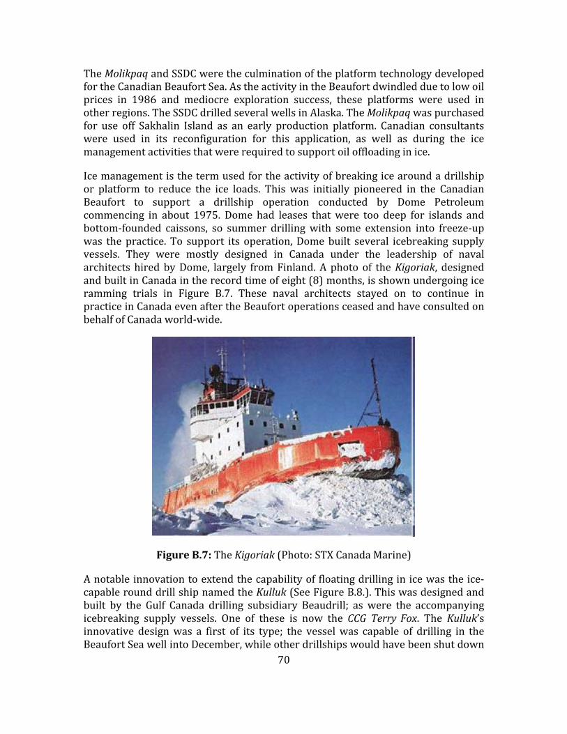
70
TheMolikpaqandSSDCweretheculminationoftheplatformtechnologydevelopedfortheCanadianBeaufortSea.AstheactivityintheBeaufortdwindledduetolowoilprices in 1986 and mediocre exploration success, these platforms were used inotherregions.TheSSDCdrilledseveralwellsinAlaska.TheMolikpaqwaspurchasedfor use off Sakhalin Island as an early production platform. Canadian consultantswere used in its reconfiguration for this application, as well as during the icemanagementactivitiesthatwererequiredtosupportoiloffloadinginice.
Icemanagementisthetermusedfortheactivityofbreakingicearoundadrillshipor platform to reduce the ice loads. This was initially pioneered in the CanadianBeaufort to support a drillship operation conducted by Dome Petroleumcommencing in about 1975. Dome had leases thatwere too deep for islands andbottom‐founded caissons, so summer drillingwith some extension into freeze‐upwas thepractice. To support its operation,Domebuilt several icebreaking supplyvessels. They were mostly designed in Canada under the leadership of navalarchitects hiredbyDome, largely fromFinland.A photo of theKigoriak, designedandbuiltinCanadaintherecordtimeofeight(8)months,isshownundergoingiceramming trials in Figure B.7. These naval architects stayed on to continue inpracticeinCanadaevenaftertheBeaufortoperationsceasedandhaveconsultedonbehalfofCanadaworld‐wide.
FigureB.7:TheKigoriak(Photo:STXCanadaMarine)
Anotableinnovationtoextendthecapabilityof floatingdrillinginicewastheice‐capablerounddrillshipnamedtheKulluk(SeeFigureB.8.).Thiswasdesignedandbuilt by the Gulf Canada drilling subsidiary Beaudrill; as were the accompanyingicebreaking supply vessels. One of these is now the CCG TerryFox. The Kulluk’sinnovative designwas a first of its type; the vesselwas capable of drilling in theBeaufortSeawellintoDecember,whileotherdrillshipswouldhavebeenshutdown

71
inOctober.Fortunately, themooring lineswere instrumentedso that ice loadsonthevesselweremeasured.Thisisanothervaluabledatasetforiceloadsonvesselsin managed ice and continues to be the basis for much analysis and for thevalidationandcalibrationoficeloadmodels.
FigureB.8:TheKulluk:anice‐resistantrounddrillshipdevelopedbyGulfCanada[BeaufortSea,circa1985](Photo:BrianWright)
AnotherinnovationpioneeredbyCanadianengineersandusedintheBeaufortSeawas that of drilling from the ice itself.Drilling froma thickened floating ice sheetwas first done by Panarctic Oils in the Canadian Archipelago in the 1970s(Masterson, 2013). Several gas discoveries were made but never developed. Thesame engineers who developed this capability recognized that ice could bethickenedquicklybysprayingwaterintocoldairtoincreasetheheattransferand,therefore,freezingrates.ThistechniquewasappliedtoproducegroundedicepadsinshallowwaterintheBeaufortSea.Afterresearchtoensuretheirstability,thesespray ice islands were used for exploratory drilling of 2 wells in the CanadianBeaufort and 5wells in the Alaskan offshore. An example of one spray ice islandconstructedanddrilledfrombyEsso/Imperialin1988‐89isshowninFigureB.9.
Intotal,duringtheperiod1972–1992about86wellsweredrilledintheCanadianBeaufort.
ThetotaldiscoveredresourcesintheCanadianBeaufortareestimatedatabout1.2billionbarrelsofoil(mostlyoffshore)andabout10TCFofgas(mostlyonshoreintheDelta). Although no production of either oil or gas has occurred yet from theCanadianBeaufort Sea,many of the activities during the exploration periodwereaimedatdevelopingtechnologyforproduction.Infact,alltheiceloadresearchandknowledgegainedareapplicabletoproductionplatforms.Muchworkwasalsodone

72
on pipelines both onshore and offshore, as well as on icebreaking oil and LNGtankers.
Until the recent oil price drop (2014‐15), work was underway to study thedevelopment of existing discoveries, in particular the Amauligak field, which isestimatedtocontainabout300millionbarrelsofoil.Thisworkisnowonhold.
It is a fair final statement to say that theperiodof CanadianBeaufort oil and gasexploration between 1970 and 1992 created significant knowledge and CanadianexpertiseinArcticoffshoreengineeringthatpersiststothepresentdayandisstillininternationaldemand(asothercasehistorieswillillustrate).
AppendixIshowsalistofexplorationwellsdrilledintheCanadianBeaufortSeabydateandplatformtype(fromCallow,2012).
FigureB.9:TheNipterkSprayIceIsland (Photo:EssoResourcesCanada/ImperialOil)
B.3 TheArcticIslands:ExplorationandPilotProduction
ThefollowingtextisextractedfromapaperbyDanMasterson(2013).
The story of oil and gas exploration in the Arctic Islands of Canada and in theSverdrupBasinofthatregionislargelythestoryofPanarcticOilsLimited.PanarcticwasincorporatedMay27,1966byFederalLettersPatentandoperationsstartedin1968withthefirstseismicwork.J.C.SprouleofCalgarywasamajorforcebehinditsformation. Panarctic was an industry/government consortium established toexplore for oil and gas in theCanadianArctic Islands,withup to37participatingcompanies.Panarcticdrilled150wellsoveranareameasuringsome850by1200km. The most northerly well was located approximately 80°45′ N on Ellesmere

73
Islandandthemostsoutherlywellwasat72°40′NonPrinceofWalesIsland.38ofthesewellsweredrilledoffshorefromfloatingiceplatformsinwaterdepthsofupto550m.500km3(17.5trillionft3)ofnaturalgasreserveswasdiscoveredoverthisperiodandsmalloilreserveswerediscoveredatBentHorn.Alloftheoffshorewellsattempted were drilled, logged and tested as planned, a proof of the viability ofusingiceasasupportfordrilling.Inspiteof largedistances,extremeweatherandpermafrost, the operations were successful and had no lasting effect on theenvironment.
ExploringforoilandgasintheCanadianArcticIslandspresentsenormousphysical,logistical andorganizational challenges. Explorationbegan in 1961 and continueduntil1986.PanarcticOilsLtd,an industry/governmentconsortium,wasformedin1966topoolresourcesforthischallengingandexpensiveundertaking.
Panarctic'seffort formedtheprincipalone,andtheydrilled150wells,38of thembeing offshore from floating ice platforms thickened to between 5 and 6 m.Conventional landrigswereusedtodrillboththeonshoreandoffshorewells.Rigdesignwasmodularizedtoimproveefficiency.
Panarctic collected 35,000 km of seismic line data during the time it operated,16,000kmofthisbeingfromtheoffshoreicepack. Icethicknesswasmeasuredatshot holes drilled through the ice and 83,606 thickness measurements wereobtainedbetween1971and1980.
FigureB.10:MapofArcticIslandsshowingthewellsdrilled(Masterson,2013)
Transportationoverlargedistancesunderhostileweatherconditionswaseffectedusing aircraft and overland and over ice vehicles, both standard trucks and all‐terrain vehicles. Supply of rigs, equipment and bulk material from the south

74
occurred using sealift and Hercules C‐130 transport. Crew changes wereaccomplishedbyLockheedElectra and727/737aircraft.Theseaircraft landedonlandstripsoroffshoreonstripspreparedontheseaice.Herculesaircraftbroughtrigsandsuppliestotheremotelocations.253loadswererequired.Helicopters,suchastheSigorskyS61,ferriedconstructionequipmentandcampstositesatstart‐up.
Wellcostswererelativelylowforafrontierarea.Anonshorewellcouldbedrilledtoadepthof3000mfor$11to$12million.Anoffshorewellofsimilardepthwouldcost$22to$23million.Earlywellsweredrilledfor$2to$4million.Laterwellscostmorebecauseofseveralfactors,includingincreaseddepthofthewellsnecessitatinglarger and more sophisticated rigs and because the operation included morestringenthealthandsafetymeasuresandmoresophisticatedandcostlycampsandrelatedsupport.
Drillingoffshore from iceplatforms required continuousquality assuranceduringconstruction and performance monitoring during drilling. Basic information wasrelayed south and toNRC inOttawa as part of the daily construction anddrillingreporting.
AtrialgasproductionwascompletedatDrakeF‐76in1978.Anoffshorewellwasdrilledfromafloatingiceplatformandapipelinewasconnectedfromshoretothewell using the sea ice as a support. Two 152mm flowlines, both heat traced, oneinsulated and one not insulated in a bundlewere installed. Maximum flow of 10m3/sat10MPapressurewasachievedduringtheflowtest.ThewellwasshutininNovember1978andwaspluggedandabandonedin1995.
PanarcticdiscoveredasmalloilfieldatBentHornonCameronIslandin1974,andbetween1985and19972.8millionbarrelsofoilwere tankeredsouthduring thelatesummer/earlyfallperiod.
B.4 PolarisMineProject–LittleCornwallisIsland
The Polaris Mine was the world’s most northerly metal mine, located on LittleCornwallis Island, about 100 kilometres north of Resolute. Underground mineconstruction started in 1980, with first production in 1981. Annual ore inproductioncontinueduntil theminewasclosed in2002,withanannualoutputof250,000 to 300,000 tons of zinc and lead concentrates. These concentrateswerestoredinthelargebuildingshowninFigureB.11andduringthesummershippingseasonweretransportedtoEurope.

75
FigureB.11:PolarisMinesite,showingaccommodation,mill,storageshedandmarinedock(Photo:TekResources)
ThePolarisMineprojecthasanumberoffeaturesrelevanttoNorthernOceans.Notonlydid itsuccessfullyexport itsoreconcentratebyshipto internationalmarketsforover20years,butthedevelopmentwasalsoaprototypeforbuildinglarge‐scaleintegrated barge‐mounted facilities in southern Canada and bringing them north.Thissavedconsiderabletimeandeffortover“stick‐building”aplantonsite.
FigureB.12:Processbargebeingtowednorth(Photo:DavieShipping)
Theentiremineralprocessingplant,powerplantandworkshopwerebuiltuponabarge,whichwastowed5,600kilometresfromQuebectotheminesite.Thebargewas then floated intoplace inapre‐excavatedberth,whichwasdrainedandbackfilled.
One importantaspectof theproject fromamarineengineeringpointof viewwasthesuccessfuluseofasheet‐piledcellulardockstructure inaquiteactivechannelwherethedockwasexposedtosignificantheavywinterice.

76
FigureB.13:Exportoforeconcentrateswithshipalongsidedock(Photo:TekCominco)
Figure B.14: MVArctic icebreaking bulker, the main transport ship for PolarisProject(Photo:FednavLtd.)
Theprojectisalsoimportantfornorthernengineeringinthatithasgonefullcyclefromexplorationtodevelopmenttooperationtodecommissioningtoreclamation.

77
FigureB.15:Polarisprojectafterdecommissioningandreclamation(Photo:TekCominco)
B.5 ArcticPilotProject–LNGfromtheArcticIslands
LargereservesofnaturalgaswereidentifiedintheCanadianArcticIslandsbetweenlate1960sandearly1980s,andamajorproject,theArcticPilotProject(APP),wasconceivedtoanswerimportantquestionsrelatingtodevelopingafeasiblesolutionto transport gas from the Arctic to eastern Canadian markets. The APP, led byPetroCanada,wasoneof the leadingArcticprojects inearly1980sandsignificantdevelopmentworkwasundertakenonadvancingArcticmarine technologybeforethelowerenergypricesofthemid‐1980sputtheprojectontheshelf.
Thepilotprojectwasdesignedtoaddresstwoquestions:
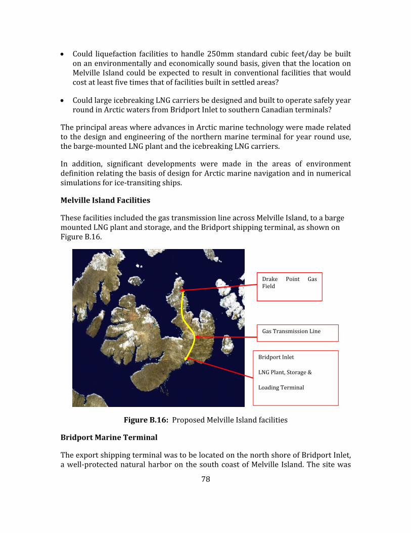
78
Could liquefaction facilities tohandle250mmstandard cubic feet/daybebuiltonanenvironmentallyandeconomicallysoundbasis,giventhatthelocationonMelville Islandcouldbeexpectedtoresult inconventional facilities thatwouldcostatleastfivetimesthatoffacilitiesbuiltinsettledareas?
CouldlargeicebreakingLNGcarriersbedesignedandbuilttooperatesafelyyearroundinArcticwatersfromBridportInlettosouthernCanadianterminals?
TheprincipalareaswhereadvancesinArcticmarinetechnologyweremaderelatedtothedesignandengineeringofthenorthernmarineterminalforyearrounduse,thebarge‐mountedLNGplantandtheicebreakingLNGcarriers.
In addition, significant developments were made in the areas of environmentdefinitionrelatingthebasisofdesignforArcticmarinenavigationandinnumericalsimulationsforice‐transitingships.
MelvilleIslandFacilities
ThesefacilitiesincludedthegastransmissionlineacrossMelvilleIsland,toabargemountedLNGplantandstorage,andtheBridportshippingterminal,asshownonFigureB.16.
FigureB.16:ProposedMelvilleIslandfacilities
BridportMarineTerminal
TheexportshippingterminalwastobelocatedonthenorthshoreofBridportInlet,awell‐protectednaturalharboronthesouthcoastofMelville Island.Thesitewas
BridportInlet
LNGPlant,Storage&
LoadingTerminal
Drake Point GasField
GasTransmissionLine

79
well situated for approach by sea, permitting a straight‐in run from ViscountMelvilleSound.
Afterexaminationofsitesinthearea,itwasdecidedthatthemostsuitablelocationfor the terminal would be just east of theMecham River Delta. This area is of atypicalArcticdeltasoilstructurewithfrozenfinegrainsands,siltsandclays.DesignoftheBridportshippingterminalwasbasedondetailedtechnicalandbathymetricinformation acquired during the spring of 1978 and on experience with anoperatingfacilityattheNanisivikminesiteonBaffinIsland.
The design was based on a rock‐filled gravity structure in which the rock iscontainedbyinterlockingsteelpilesdrivenfromaniceplatform.Thecircularsheetmetalcellsweretobeabout25mindiameter,whilethemainpierwastobeabout450m long and comprising 6 single and 1 pair of cells with a full length accessroadwayonabackfillfoundation.
Berthing of vessels in ice‐filled waters is well known to be very difficult. Manysituationsarerecordedwhenvesselscouldnotpositionthemselvessatisfactorilytoproceed with and complete their loading or unloading procedures, due to thepresenceoficeattheberthinterface.Thesedifficulties,whichwerecompoundedbyextremesof temperature,were confirmedbyan icebasin study. Itwas concludedthat an active and reliable system of icemanagement or control of the ice coverwithin the terminal areawas required, otherwise successful docking couldnot beassuredyearround.
The barge‐mounted liquefaction plant and storage facilities were planned to beconstructedinshipyardsinsouthernCanadaandtowedtoBridportInletduringthesix‐weekopen‐waterseason.Thismethodwaschoseninordertocontrolcostsandscheduleandtoreducetheimpactofconstructiononthenorthernenvironmentandeconomy. These floating facilities were to be moored inside a protected dockstructurethatwasalsotoactastheLNGcarriers'loadingterminal.
MarineTransportation
Harshenvironmental conditions (2m level ice, rubble ice fields, up to5 ice ridgesper mile, high winds, low temperatures, extended periods of darkness and thepresence of icebergs in Baffin Bay and the Labrador Coast)made planning year‐roundmarinetransportationalongtheproposedroutequitechallenging.ThemainshippingroutealternativesareshownonFigureB.17.
Toassessthecapabilityoftheproposedmarinefleettooperateyearround,liftingtherequiredproductionandsafelyandefficientlytransportingtheLNGtomarket,PetroCanada developed a sophisticated computer simulation tool with which thesize and performance of any component (including the plant, storage and ships

80
couldbevaried),thusallowinganassessmentoftheresultingsystemperformance,includinganychangeinthedeliveredcostoftheLNGtosouthernmarkets.
FigureB.17:LNGShippingRoutes–MelvilleIslandtoEasternCanada
Themarinetransportationsimulationprogramhasfourbasiccomponentmodels:
The Environmental Model consisted of a bank of information on theenvironmentalconditionsalongtheroutewithrespecttotime.Theseconditionscovered6fullyears,1972‐1978,forwhichgooddatawereavailable.Thedataincluded ice thickness, ice coverage, ice type, ice pressure, iceberg density,ambient air temperature, visibility, and wind velocity and direction. Thisinformationwasobtainedfromsatelliteimagery,localobservations,fieldstudiesand over‐flights. Three over‐flights were conducted in the spring of 1978 tofurther study ice conditions. These flights are complementary to satelliteimagery;theyidentifiedthenumberoficeridgesbymeansofimpulseradar(IR),side‐lookingairborneradar(SLAR)andthermalIR.Inaddition,anon‐iceridgestudywasconducted inViscountMelvilleSound(SeeFigureB.18). Thisstudyinvolvedthecross‐sectioningofthe40ridgesofvaryingsizesandtypesinorderto determine energy required to transit, degree of consolidation and internalstrength.Thisstudyprovidedground‐truthingofover‐flights.

81
FigureB.18:On‐icesurveyofmarinerouteinViscountMelvilleSound(Photo:HydrometricsLLC)
TheShipPerformanceModelcontainedanumberofmathematicalrepresentationsoftheship'sperformanceingiveniceconditions,includinglevelice,ridges,multi‐yearice andbroken ice. These equationsof shipmotionwerederived froma seriesoftankmodeltests.
The FacilityManipulationModel monitored the progress of the vessels. It alsorecordedandintegratedtheenergyandtimeexpendedforeachlegoftheroute.
ThePresentationOutputLogicModel converted the generated outputs, presentingsuch information as elapsed voyage times, fuel consumed, boil‐off generated andLNGdelivered.
Fromstudiescarriedoutwiththistool,thetwovesselsproposedwouldhavehadanLNG cargo capacity of140,000m3 each andwere335m longby40mwide. FigureB.19showsanartist’simpressionoftheseships.
TheseArcticClass7vesselsweredesignedwith180,OOObhp,fourtofivetimesthatofstandardLNGshipsoftheday,ofcomparablesize,andtheywouldhavehadmorethandoublethehullsteelweight.Basedonallworkandstudiescarriedout,itwasconcluded that carriers could be built which could operate year round fromBridportInlettotheCanadianEastCoast.

82
FigureB.19:Artist’simpressionoficebreakingLNGcarrier
RegasificationTerminal
The APP planned potential regasification terminals at one of three potentiallocations inEasternCanada:on theSt. LawrenceRiver,downstream fromQuebecCity; on the Strait of Canso, Nova Scotia; or at Lornevelle, New Brunswick. Thisfacilitywould have provided a terminal dock and unloading facilities for the LNGcarriers,plustwo100,000m3storagetankstoprovidethenecessarystorage.
Environmental
TheAPPwastobedesigned,constructed,andoperatedwithminimaldisruptiontotheArcticenvironment.TheecosystemsonMelville Islandareof lowproductivityand the island has limited precipitation, intense cold, and very short growingseasons. In contrast, somemarine ecosystems fromEastern Parry Channel to theScotianShelfarehighlyproductive.However,theLNGcarrierroutehasbeenchosentominimizeencounterswithsuchsystems.
LNGSafety
OceanshippingofLNGhasbeencarriedoutsince1959.Shipmentshavebeenmadein climates from tropical to sub‐Arctic. These operations have had an excellentsafetyrecord,whichcanbeattributedtothehighqualityofLNGcarrierdesign,theselection and training of LNG carrier crews, and the effectiveness of their safetyprocedures.ThetwoAPPcarriersandterminalfacilitieswouldhavemetorexceed

83
thedesign,operation,andsafetycriteriaofallsuchcarriersandfacilitiescurrentlyinservicearoundtheworld.
ThesafetyoftheArcticPilotProjectwastobeenhancedby:
thestrengthofthestructuraldesign,thehighlevelofpropulsivepowerandthesuperiormaneuverabilityoftheicebreakingcarriers;
the safety distance from coast lines and population centres that was to bemaintainedbythecarriers;and
choice of location for the terminal facilities, both in theNorth and South,wellremovedfromdenselypopulatedareas.
Conclusions
AlthoughtheArcticPilotProjectneverbecamereality,itdidprovideanopportunityfor significant advances in Arctic marine technology, specifically in the followingareas:
northernmarineterminalsdesignedforyearrounduse,
barge‐mountedplant fornorthern resourceprojects, includingoil andgas andmining,
simulationofArcticmarine transportationsystems,whichallowedavarietyofoptionstobeexaminedfortechnicalandcommercialfeasibility,and
designoflargeicebreakingshipscapableofcarryingbulkliquidanddrycargoes.
Onelessonthatmaybeworthfurtherconsiderationisthatbyinitiatingavisionaryproject,many advances can bemade thatmay have enduring value. USPresidentKennedyinitiatedsuchasvisionaryprojectwithhisinjunctiontolandamanonthemoonwithinadecade;whiletheAPPmaynotquitebeinthatleague,itdidcreatesimilarvalueonasomewhatsmallerscale.
ItmaypointustothevalueofafutureArcticvisionaryprojectwhichcouldprovideanexcellentmeanstofocusNorthernOceanengineeringdevelopments,ratherthancontinuing the current practice of having individual research and developmenteffortsongoing,perhapswithinaroadmapbutmoreoftenlargelyindependentlyofoneanother.

84
B.6 Voisey’sBayCaseStudy
Background
TheVoisey’sBaynickeldepositwasdiscoveredinSeptember1993bytwodiamondprospectors.ThefindwasoneofthemostsignificantmineraldiscoveriesinCanadainthelate20thcentury.Itisestimatedtocontain141milliontonnesat1.6%nickel.Afterseveralyearsofnegotiations,thefindwassoldin1996toaCanadianminingcompany,Inco,for$4.3billion.Thiswasfollowedby6yearsofnegotiationswiththegovernmentofNewfoundlandandLabrador,aswellaswiththeLabradorInnuandInuit,beforeanagreementtoexploittheresourcewasreachedin2002. Theminebeganoperationin2005,withthefirstconcentrateshippedinOctoberofthatyear.In2006IncowaspurchasedbyValeandisnowknownasValeCanada.
The Voisey’s Bay mine is located in northern Labrador, about 35 kilometressouthwest of Nain. The project encompasses amine and concentrator at Voisey’sBayandportfacilitiesinEdward’sCove,AnaktalakBay.Themillisadjacenttothemine and uses crushing, grinding and flotation to produce concentrate. Theconcentrate is trucked 11 km to a storage building at Edward’s Cove. Theminecurrently is an open pit operation, but is expected to move to an undergroundoperationinabout2023andcontinueuntil2040. Thecurrentworkforce isabout450andoperatesona fly‐in‐fly‐outbasis;with theundergroundoperation, about350additionalworkersareforeseen.
FromaNorthernOceansperspective,theprojectisofinterestbecausethepresenceof sea ice fromDecember through to June. This affected thedesign of thewharf,shippingoutofconcentrateand traditionaluseof the icecoverby local residents.Theseengineeringandlocalfactorshadtobeaddressedandreconciled.
IceConditions
The port facilities in EdwardCove are at the end of an approximately 90km‐longpassageway between numerous islands leading in from the Labrador Sea. Thepositionof the landfast iceedgevaries throughout thewinter, typicallyreachingamaximuminMarch,andtheouterextent isvariable fromyeartoyear. The ice inthispassageis landfastandcanreachthicknessesgreaterthan1m. IceconditionsbeyondthebeltofislandsarecharacterizedbythesoutherlydriftingLabradorpack,whichispresentJanuarythroughtolateJune.Itwidthcanvaryfrom50to200km.Driftratesofthepackarefrom20to120km/day.Oldiceatconcentrationsofonetenth can be found in the pack from February tomid‐June. The pack comprisesgreatly deformed ice in floes some 5‐8m thick and 50‐90m across; however, theaverage thickness of the pack is about 1.5 to 2 m. The boundary between thelandfast ice and themoving pack is a shear zonewith ridges up to 5m high andextendingfortensofkmkilometres. Thiszone,whichmayalsobeunderpressure,presentsaformidableobstacletonavigation. Finally, icebergsofvarioussizesarepresentyearroundalongtheLabradorcoast.

85
Marineterminal
ThemarineterminalatEdwardsCovefacilitatesconcentrateexportfromthemine’soperationsandoffloadingofre‐supplycargo(SeeFigureB.20).Theterminalisusedfor year‐round shipping and the bay is subject to ice conditions. Therefore, inadditiontonormalrequirementsontheterminal, iceloadinghadtobeconsideredinthedesignandconstruction(MacPhersonandKullmann,2008).AsisthecaseformanyArcticlocations,theterminalislocatedinanenvironmentallysensitivearea.This limited the scope of the in‐water work. Documented experience at otherwharvesintheCanadianArcticandlocalmeasurementswereusedtoestablishtheaverageandextremeiceconditionsfordesign.CanadianstandardsCAN/CSAS471‐92(1992)andCAN/CSAS6‐00(2000)wereusedtoestablishiceloadsanddesignicepressures. A characteristic of the landfast ice and tidal range of about 2m is thebuild‐upofalargeicebustlethatcouldlimitaccesstothewharfface.Acantileveredwharf deckwas incorporated to allow the shipdirect access to thewharf face. Asteel sheetpile cell (SSPC) structurewasused for thewharf. The SSPC structureselectedtoformthewharfstructurewasaneconomicalsolutiontosatisfythepoorground conditions at the site. However, the sheet pile interlocks comprising thestructure are highly susceptible to ice‐loading damage. Therefore, a means ofstrengthening the cell sheet pileswas needed towithstand the high localized icepressures. The strengthening system developed was to install of a number ofprecastreinforcedconcretepanelsdesignedtowithstandiceimpactforces. Theseprecast panelswere installeddirectly behind the sheetpiles to provide increasedresistance.
FigureB.20:Marineterminalshowingwharf,shiploaderconveyer,concentrate
storagebuildingandMVUmiakIapproachingwharf(http://www.vale.com/canada/EN/business/mining/nickel/vale‐canada/voiseys‐
bay/Pages/default.aspx)

86
Shipandshippingoperation
Akey element of the success of theVoisey’s Bay project is the provision of year‐round shipping of concentrate from the site. With a long‐term contract coveringtransportation of concentrate, FEDNAV, a Montreal‐based Canadian shippingcompany with extensive experience in the Arctic, ordered the UmiakI, a 32,000tonne icebreakingbulk carrier (SeeFigureB.21). Thevessel isDNVclass ICE‐15,oneofthehighestICEclasses,andiscapableofbreaking1.5mthickiceunassisted.TheUmiakI isthemostpowerfulvesselofitstype. Itincorporatesanicebreakingbow,awaterwashsystemtohelpreducefrictioninice,aV‐shapedsternandaniceknife toprotect the rudder ‐ all features thatFEDNAV’soperational experience intheArcticshowedtobenecessaryforsafeandefficientoperationinice. Wheniceconditions exceed those for continuous forward progress through the ice, forexampleridgesorthickpackicefloes,thevesselhastoreverseandramtheice.The22‐MWenginedrivesa single controlled‐pitchpropeller inanozzle,whichallowsforquickreversalofthrust,highthrustatlowspeedsandprotectionofthepropellerfrom icedamage. Eachnickel concentratecargo isworthseveralhundredmilliondollars,soreliableandtimelyoperationicecritical.
FigureB.21:UmiakIinice(Photo:DepartmentofFisheriesandOceansCanada)
In addition to the technology of the vessel itself,UmiakI uses the Enfotec IceNavsystem,ashipboardnavigationalsoftwarepackagetodisplaysatelliteimagerywithanoverlayofradarfromamarineradar.Themainconstituentsofthesystemarethenavigation module and the marine radar module, operating on a single PC withdisplays on twomonitors. The twomodules are completely integratedwith routeplansandiceinformationoverlaidononemonitorandcurrentmarineradarontheother monitor (See Figure B.22). The ice information, including forecasts of icepressure from the National Research Council, is provided by the Canadian IceService.IceNavfacilitatessafeandefficientrouteplanningandnavigationinice.

87
FigureB.22:EnfoTecIceNavdisplaysoficeconditionsandmarineradarontheLabradorcoast(ScreencapturecourtesyofIvanaKubat,NRConboardUmiakI)
Shareduseofthelandfasticecover
This topic moves away from engineering, but demonstrates that projects in theArctichavetoconsideraspectsotherthanthosedirectlyrelatedtotechnicalissues.The ice cover in the winter is a convenient surface for travel by local residents(RowellandMetcalfe,2005a).Itwasnecessarytodevelopashippingschedulethatwould respect the traditional use of the landfast ice cover and still allow a viableshipping operation (Rowell and Metcalfe, 2005b). The winter season has beendividedintosections.Intheearlypartofthewinter,December7toJanuary21,noshipping is allowed. Then, from January22 toApril 6,provision ismade for fournickel concentrate shipments. During thisperiod the ship alwaysoperates in thesametrack,marginsofthebrokentrackaremarked,apontoonbridgeplacedacrossthetrackataconvenientcrossingplaceistemporarilymovedforeachtransit,andpublicnoticesoftimingofshiptransitinandoutaremade. Again,fromApril7toMay21,no shipping is allowed. Finally, fromMay22 toDecember6, shippingofnickel and copper, plus any other shipments is allowed. This system has beensuccessfullyusedforanumberofwinters.
B.7 EastCoastDevelopment:WhiteRose
Three oil fields are already in production on the east coast of Canada: Hibernia,TerraNovaandWhiteRose.TheHebronoffshoreplatform(gravity‐based)isunderconstruction, and a wellhead platform tied back to the existing SeaRoseFPSO isbeingconsideredfortheWhiteRoseproject.Allofthesedevelopmentshavetakenplace in areas where sea ice and icebergs pose a challenge to the design ofinstallations.Twostrategieswithregardtopossibleinteractionwithicebergshavebeen considered. The structure can be designed to resist iceberg loading: forexample,gravity‐basedstructures,whichgenerallycannotbemovedfromlocation.Significant effort ismade to detect icebergs using radar and othermeans, and to

88
removethreateningicebergsbytowing.Floatingstructures,ontheotherhand,canbedesignedtodisconnect.
Pack ice can be expected at theWhite Rose location every few years, with 5/10coverage 1 out of 4 years. Ice is present for an average 17 days a year, with anaverage thickness of 0.4 metres. The average annual number of icebergs in thedegreesquarewastakenas0.95.ThederivedlengthdistributionisshowninFigureB.23,withthemanagementpolicyillustratedinFigureB.24.
The TerraNova and the SeaRose are examples of turret‐moored disconnectableFloatingProduction,StorageandOffloadingunits(FPSOs).Thestrategyinthiscaseis toplandisconnectionandremovalof theunit if an iceberg cannotbe removed.There is also the situation that detection of icebergs can be less reliable in thepresence of high sea states, and at the same time smaller icebergs will beaccelerated by the wave action, with much increased velocity and consequentlykineticenergy.
FigureB.23:Iceberglengthdistribution(Jordaanetal.,2014)

89
FigureB.24:Strategicicemanagement(Jordaanetal.,2014)
Thesituationdescribedposesacomplexsituationfordesign;thesolutionwasfoundby means of probabilistic analysis. Methods based on this approach have beenpioneeredinCanada,togetherwithguidanceonsafetylevelsinCSAS471(CanadianStandards Association Standard: General Requirements, Design Criteria, theEnvironment, and Loads) and ISO 19906:2010 (Petroleum and Natural GasIndustries—ArcticOffshoreStructures).Theanalysisaccountedfor factorssuchasarealdensityof icebergs, icemanagement,environmentalconditions includingseastate, and the mechanics of the interaction. Design was based on Safety Class 1,wherein failure would result in great risk to life or a high potential forenvironmentaldamage,fortheloadingconditionunderconsiderationwithaTargetSafetyLevelof1in100,000yearsor10‐5perannum.
The final recommendationsweremade regarding local and globalpressures frompotential collisionswith ice.These formedthebasisof thedesignandselectionofsteelstructureandplating.DesignchecksonstructuralresponsewerealsocarriedoutbytheteaminStJohn’s.Probabilisticmethodology,togetherwithdevelopmentsintheunderstandingoficemechanics,hasledtomuchimprovedcompetitivenessofthedesigns,accountingforcostandsafety.
Observation Zone - Ice monitoring
Control Zone - Iceberg towing
Alert Zone - T-time - Suspend Ops
Exclusion Zone - disconnection

90
FigureB.25:TheWhiterosedevelopmentshowingtheSeaRosevesselandtanker(http://www.offshoreenergytoday.com/canada‐approves‐amendment‐to‐huskys‐
white‐rose‐fdp/)
FigureB.26:TheSeaRoseunderconstruction[Marystown,NL–circa2005](Photo:Kiewit)

91
B.8 KashaganFieldDevelopment–NorthCaspianSea
TheNorthCaspianSeais ice‐coveredfor3–4monthseachwinter.TheiceismuchlessseverethanintheArcticOcean;nevertheless, icehassignificanteffectsonthedesignandoperationofoffshoreplatformsandpipelines.In2000theKashaganfieldwasdiscoveredandisestimatedtocontainabout13billionbarrelsofrecoverableoil, making it the world’s largest discovery in the past 30 years. Partners in thisdevelopment include ExxonMobil, Shell, Total, ConocoPhillips, ENI andKazMunayGas.TheKasahaganfieldisabout70kmoffshorebutthewaterisshallow,atonly4–7m.
Inlate2000aCanadiangroup(KRCA)wasinvitedbytheKashkaganconsortiumtobid on collecting ice data and developing ice design criteria, competing againstFinnishandRussiangroups.TheyweresuccessfulandinitiatedworkinJanuaryof2001(SeeFigureB.27).ItisbelievedthattheirsuccesswasdueinnosmallparttotheextensiveexperiencegainedintheCanadianBeaufortSea. Todayin2014,theCanadiangrouphashaditscontractextendedfourtimesandisstillinvolvedasthisprojecthasgonefromexplorationanddelineationdrillingintodevelopment.Atthepeakoftheworktherewereupto20Canadianexpertsinvolved.
The development of the Kashagan field involves numerous platforms which aremostlyretainedislands.Again, theknowledgegainedfromtheBeaufortSeaoniceinteractionwithwidestructuresinshallowwaterwasavitalinput.Newandrefinedapproachesusedinthisdevelopmenthaveincluded:probabilisticiceloadmodellingon wide structures in shallow water, accounting for ice rubble; an ice rubblesimulator to help in the positioning of ice barriers; methods for predicting andprotecting against ice encroachment onto low‐freeboard retained islands. Anexampleoficerubblebuild‐upandiceencroachmentareshowninFiguresB.28andB.29.
Another importantaspectof theKashagandevelopment ispipelinesboth toshoreandbetweenthevariousproductionandprocessingislands.Inalltherewillbeover1000kmofpipelines.The sea floor is subject to frequent ice scouring (SeeFigureB.30).TheCanadianteamhasplayedavitalroleindeterminingsafeburialdepthsfor these lines to protect against ice interaction and damage. The approachesdevelopedforKashaganpipelineburialareconsideredstate‐of‐the‐artandwillnowbe available for use in other Arctic regions (including Canada) as developmentsoccur.
Lastly,CanadianexpertshavealsobeenpartoftheteamsinvolvediniceforecastingfortheNorthCaspian,aswellasactingasiceobserversandadvisorsonthedrillingrigs.
Insummary,althoughtheoilandgasdevelopmentsintheNorthCaspianSeaarefarfrom Canada and not strictly in the Arctic, this case history demonstrates how

92
Canadianexpertisehasbeenvital inenabling thedevelopments.Also, it shouldbenoted that Canadian experts successfully competed against Scandinavian andRussian expertise to be engaged. A rough estimate of revenues to Canadiancompanies from 2001 to 2014 is about $10 million. No Canadian governmentsubsidieswereinvolvedinthesuccessfulbiddingandimplementationofthiswork.Nevertheless, the successful Canadian private company subcontracted significantworktotheNationalResearchCouncilandMemorialUniversity(C‐CORE).
FigureB.27:CanadiansandKazakhcolleaguesgatheringicedataintheNorthCaspianSea(Photo:KRCroasdale&AssociatesLtd.)

93
FigureB.28:Icerubblebuild‐upagainstislandandicebarriers(PhotoscourtesyofDerekMayne[top]andRuneNilsen[bottom])
FigureB.29:Iceencroachmentonlow‐freeboardstructures(Photo:EricLemee)

94
FigureB.30:Icescouringoftheseafloor,NorthCaspianSea(Photo:K R Croasdale & Associates Ltd.)
B.9 ShtokmanField:IcebergloadsforfloaterinBarentsSea
Introduction
Icebergs occur in many areas of the Arctic and subarctic: for example, WestGreenland, east of Baffin Island and Labrador, on the Grand Banks, southeastGreenland, in theareaneighbouringSvalbard, in theBarentsSea,andmanyotherareas in the Russian arctic. Determination of iceberg loads for design of offshorefacilities forexplorationandespecially forproduction isan importantengineeringtask.
Engineering design aims at an appropriate balance between safety and economy.Theuse of probabilisticmethodsoffers a solution that assists in obtaining such abalance. The specification of iceberg loads is guided by the ISO 19906 (2010)InternationalStandard.Themethodologyusedinthepresentstudyresultsinload‐exceedancecurvesthatcanbeusedtodeterminedesign loadsatadesiredannualexceedanceprobability. In ISO19906 theExtremeLevel IceEvent (ELIE) and theAbnormalLevelIceEvent(ALIE)forthedesignofanoffshoreplatformaredefinedatannualexceedanceprobabilitiesof10–2and10–4respectivelyforL1exposure.
IceloadshavebeenmodelledusingMonteCarlomethods,whichtakeintoaccounttheunderlyingprobabilisticdistributionsofthearealdensityoftheicefeature(forexample,thenumberoficebergsper10,000km2),thesizeandmassofthefeatures,their added mass, their velocity, eccentricity of the collision, forces from

95
surrounding pack ice, compliance of the structure, and the strength of the ice.Previous work focussed on the Grand Banks, where two floating productionplatforms are now operating, the TerraNova and SeaRose FPSOs. Probabilisticmethodsweredevelopedforthesedevelopments.Extensionofthemethodologyforuse in other areas is of considerable interest. An example is suggested in FigureB.31.Themoderating influenceof theNorthAtlanticCurrent results in conditionsnorthofNorwayandintheregionofSvalbardthataresimilarinmanyrespectstothoseoffshoreNewfoundland.
Modelling
The floating vessel considered in the analysis is illustrated in Figure B.32. Thedetermination of iceberg design loads requires the following inputs for thesimulations:
arealdensityoftheicebergs;
size,velocityandshapeoftheicebergs;
concurrentseastateandassociatedhydrodynamiceffectsonicebergmotion;
eccentricityofloadingtoaccountforobliqueimpacts;
global ice pressures developed on the basis of pressure‐area relationships(derived from analysis of ship rams into hard, multi‐year ice, or otherrelationshipssuchasconstant‐pressure);and
local ice pressures associated with the design loads (also derived fromanalysisofshipramsintohardmulti‐yearice,andafunctionofthedurationofindividualimpacteventsandthefrequencywithwhichtheyoccur).
In addition to these, detection and management of icebergs, and possibledisconnectionofthefloatingunit,aremodelled.

96
FigureB.31:Somegeographicalareaswithapproximatearealdensitiesoficebergs(excludingbergybits)per104km2indicated
FigureB.32:Schematicofgenericfloatingvesselusedinstudy
(Jordaanetal.,2014)

97
FigureB.33:Hibernia,X‐Banddetectionofa50miceberg,60knotwind,0to20scans(Jordaanetal.,2014)
Models have been developed for iceberg management based on CanadianexperienceontheGrandBanks.Threekeyelementsoficebergmanagementincludedetection,towinganddisconnection.Detectionperformanceisbasedonaspecialiceradarthatisdesignedforsmalltargetdetectioninhighseas.Thesystemprocessesmultiple scans tominimize clutter and false targets. Performance is based on theprobability of detection (POD) of icebergs given iceberg size, sea state and rangefromtheplatform.FigureB.33illustratesatypicalinput.
Withoutanymanagement, theencounter frequency isabout5×10‐3perannum–less than the value at which extreme‐level design should be considered, butcertainly greater than the value used in the abnormal‐level case. The dynamicanalysisresults inmuchreduced loadsascomparedto thevaluesbasedonquasi‐staticanalysis;forexample,thequasi‐static10‐3and10‐4exceedanceloadsof10and150MNreducetoabout5and40MNrespectively(withoutmanagement).Icebergmanagementreducesthevalueatthe10‐4annualexceedancelevelto26MN.
Conclusion
Acomprehensivemethodologyhasbeendevelopedforobtainingdesign loadsdueto iceberg impacts, the original area of interest being the Grand Banks. In thepresent study, themethodologywas applied to a regionwithmuch reduced arealdensities of icebergs and a greater proportion of bergy bits. The Extreme‐Level

98
loadswere found to be zero, but significant loads and local pressures have beenfound at the Abnormal Level (10–4 annual exceedance probability). Arrival rates,globalforces(includingtheeffectsofdynamicsoficebergandvessel),mooringloadsandlocalloadshavebeendeterminedusingthemethodologyoutlined.

99
AppendixC:APOAProject listing fromGlenbowMuseumwebsite
http://www.glenbow.org/collections/search/findingAids/archhtm/apoa.cfm#series6
Project1:TheNutcrackericestrengthtests.(1969‐1972)
Project2:BeaufortSea:icemovementandcurrentsurvey.(1970‐1975)
Project3:Oceanfloorsampling,BeaufortSea.(1970‐1975)
Project4:Geologicalanalysisofoceanfloorsamples.(1970‐1972)
Project5:StudyofMackenzieDeltatundradisturbance.(1972)
Project6:Summericereconnaissance.(1970)
Project7:Cross‐countryvehiclestudy.(1970‐1972)
Project8:Arcticdrillingguidelines.(1970‐1974).IncludesminutesoftheAPOADrillingSubcommittee,1970)
Project9:Largescaleicestrengthtest:PhaseIIof"Nutcracker".(1970‐1972)
Project10:Testingwithsyntheticice.(1970)
Project11:Ornithologicalstudy,MackenzieDelta.(1970‐1972)
Project 12: All season exploratory drilling system: 0 to 200 feet ofwater. (1970‐1975)
Project13:Seasonaldrillingfromabarge.(1970‐1975)
Project14:Summericereconnaissance,BeaufortSea.(1974‐1975)
Project 15: Mackenzie Institute: travel costs for an Edmonton meeting. [emptyfolder]
Project16:Theoreticalanalysisoficefailure.(1971‐1972)
Project17:BeaufortSeapressureridgeandiceislandscouring.(1971‐1972)
Project18:Arcticdrillingconceptsreview.(1971)
Project19:analysisofrecordsshowingseabottomscouring.(1972)

100
Project20:Cementing,casing,blowoutproceduresforDIAND.(1970‐1974)
Project 20: cementing, casing, blowout procedures for DIAND: financial records.(1971‐1973)
Project21:Largewheeledlowpressurevehicle.(1971‐1974)
Project22:TransportationofhydrocarbonsfromArcticIslands.(1971)
Project23:BeaufortSeasoilanalysis.(1972)
Project24:Arcticclothingresearch.(1971‐1975)[Includesreport.]
Project25:Modeltestsimulatingiceonfixedstructures.(1971‐1975)
Project26:Modeltestsimulatingiceondrillingbarge.(1971)
Project27:CoordinationofArcticenvironmentalresearch.(1971‐1972)
Project28:BiologicaleffectsofoilinArcticseawater.(1971‐1974)
Project 29: Habakkuk: investigation of research on an artificial ice island. (1971‐1972)
Project30:BeaufortSeaexploratorydrillingsystem.(1971‐1975)
Project31:aerialreconnaissanceofice,BeaufortSea,1971.(1972‐1975)
Project32:BeaufortSeascourrecords,PhaseII.(1972‐1976)
Project33:Landfasticemovement,BeaufortSea.(1972‐1973)
Project34:Northernresourcesstudy.(1971‐1974)
Project34:Northernresourcesstudy:researchplan.(1971)
Project34:Northernoilandgasproductionrelatedemploymentopportunities:theimpact ofMackenzieDelta production: a study prepared for theArctic PetroleumOperatorsAssociation/byDennisDepape.(1973)
Project35:EnvironmentalstudyoftheBaffinBay‐DavisStraitregion.(1972‐1975)
Project36:Iceislanddestruction,BeaufortSea.(1972‐1975)
Project 37: Arctic environmental research: tundra and ecological studies on theMackenzieDeltaandDevonIsland.(1971‐1975)

101
Project 38: Testing of the effects on terrain by various types of vehicles. (1972‐1974)
Project39:Submarinepipelinestudy,offshoreMackenzieDelta.(1972‐1976)
Project40:Evaluationofmechanicalpropertiesofsalinemodelice.(1972‐1974)
Project 41: Evaluation of themechanical properties ofMichel'smodel ice. (1972‐1975)
Project42:Surveyofgravel,MackenzieDelta.(1972‐1974)
Project43:Environmentalimpactassessmentprogram,MackenzieDelta.(1972)
Project44:Photoreconnaissanceandicemovement,BeaufortSea.(1972)
Project 45: Arctic clothing study, Phase II. (1972‐1975) [Includes report. Moulddamage]
Project 46: Ice reconnaissance, Beaufort Sea, April 1972. (1972‐1973) [Moulddamage]
Project47:Icechipperevaluationtests.(1972‐1973)[Moulddamage]
Project 48: Study of vehicular traffic on theMackenzie Delta tundra. (1972‐1974[Moulddamage]
Project49:StudyofArctictransportationequipment,MackenzieDelta.(1972‐1974)[Moulddamage]
Project50:Icethicknessmeasurement.(1972‐1975)[Moulddamage]
Project51:icemovementinBeaufortSea,1972‐1973.(1972‐1973)[Moulddamage]
Project52:Measuringthecrushingstrengthofice.(1973‐1974)
Project53:CountoficeislandsinBeaufortSea,1972.(1973)
Project54:IcegeologyofthesouthernBeaufortSea.(1973‐1977)[Moulddamage]
Project 55: Arctic environmental research [Devon Island International BiologicalProgramProject].(1973‐1974)
Project56:PreparationofspecificationsforlargeArctictruck.(1973‐1974)
Project 57: Adfreeze study: effects of ice adhesion on a conical structure. (1973‐1975)

102
Project58:TaskforcereNorthernNativejobtraining.(1973‐1974)
Project59:BeaufortSeascouringstudy,PhaseIII.(1973)
Project60:BeaufortSeasummericetesting.(1973‐1974)
Project61:Environmental impactassessmentprogram,MackenzieDelta,Phase II.([1973‐1974])
Project62:Beaufortgasplanstudy,part3.[emptyfolder]
Project 63: Arctic Instuitute of North America's Beaufort Sea symposium. (1973‐1975)
Project64:Icemechanicsandicestrengthening:1973‐74Arcticfieldtestprogram,ResoluteBay.(1973‐1978)
Project 64: Vibration measurements made on an ice platform in the vicinity ofPanarctic Hecla N‐52 – for Sun Oil Company, Richardson, Texas by James E. Fix.(Garland,Tex.:TeledyneGeotech,17July1974.[Technicalreportno.74‐4])
Project 64: Sea ice thickness determination using electromagnetic subsurfaceprofiling. (SubmittedtoSunOilCompanybyA.Orange,K.Campbell&W.Corrieri.[NorthBillerica,Mass.:GeophysicalSurveySystems,April1973])
Project64:Errata.(1976)
Project64:Appendixno.I.1:rawdeflectionandwaterleveldata.(1974)
Project64:Appendixno.I.2:reduceddeflectionandflooddatatabulation.(1974)
Project64:Appendixno.I.3:reduceddeflectionversusfieldgraphs.(1974)
Project64:Appendixno.I.4:reduceddeflectionversustimegraphs.(1974)
Project64:Appendixno.II.1:rawstraingaugedata.(1974)
Project64:Appendixno.III.1:icecoretesttabulation.(1974)
Project64:Appendixno.III.2:iceblocktemperature,coresalinityandcoredensitygraphs.(1974)
Project65:Smallprototypeconetest.(1974‐1977)
Project66:Icecrushingtests,1973‐74.(1974‐1975)
Project67:Icemovement,BeaufortSea,1973‐74.(1974‐1977)

103
Project68:Propertiesofwaxmodeliceridges.(1974‐1977)
Project69:Analyticstudyoficescour.(1974‐1975)
Project70:Wind/wavehindcast,CanadianBeaufortSea.(1974)
Project71:NorthernNativejobtrainingtaskforce,1974.(1974‐1975)
Project72:BeaufortSeaEnvironmentalProgram:catalogueofprojectdescriptions,catalogueofstudyreports.(1974‐1977)
Project72:BeaufortSeaEnvironmentalProgram.(Jan.‐Mar.1974)
Project72:BeaufortSeaEnvironmentalProgram.(Apr.‐July1974)
Project72:BeaufortSeaEnvironmentalProgram.(Aug.‐Sept.1974)
Project72:BeaufortSeaEnvironmentalProgram.(Oct.‐Dec.1974)
Project72:BeaufortSeaEnvironmentalProgram.(Jan.‐Apr.1975)
Project72:BeaufortSeaEnvironmentalProgram.(June‐Sept.1975)
Project72:BeaufortSeaEnvironmentalProgram.(Oct.‐Dec.1975)
Project72:BeaufortSeaEnvironmentalProgram.(1976)
Project72:BeaufortSeaEnvironmentalProgram.(1977)
Project72:BeaufortSeaEnvironmentalProgram:Investigators'ConferenceandSeaDrillingSeminar.(Nove.1974‐Jan.1975)
Project72:BeaufortSeaEnvironmentalProgram:WindupConference.(Dec.1975‐Jan.1975)
Project72:BeaufortSeaEnvironmentalProgram.PublicInterfaceProgram.(1974‐1976)
Project73:Researchprogramonpollutionfromdrillingfluids.(1974‐1979)
Project73:Reportoncontainmentanddisposalofdrilling fluids in theNorthwestTerritories–fortheArcticPetroleumOperatorsAssociationandtheGovernmentofCanada.([S.n.]:Dames&Moore,March1974)
Project74:BanksIslanddevelopment:environmentalconsiderations.(1974‐1975)
Project75:Fieldstudyoffirst‐yearicepressureridges.(1974‐1977)

104
Project 76: Summer environmental studies:EastMackenzieBay,MackenzieDelta.(1974)
Project77:Modellingofsmallconeprototypetests.(1974‐1975)
Project 78: Environmental data gathering program: Baffin Bay, Davis Strait, andArcticIslands.(1974‐1977)
Project79:ArcticIslandicemovementstudy,1974‐1975.(1974‐1977)
Project79:Analysisofoceanographicdata forAPOAProjectNo.79 ‐prepared forPanarcticOilsLtd.,Calgary,Alberta.(Calgary:BeakConsultants,Apr.1976)
Project 80: Development of a semi‐submersible drilling system for the Arcticoffshorearea.(1974‐1975)
Project81: Icemechanics1974‐75,Arctic field testprogram,ResoluteBay. (1974‐1975)
Project82:Smallprototypeconetest,PhaseII.(1972‐1977)
Project83:LandfasticemovementintheBeaufortSea,1974‐75.(1975‐1977)
Project84:In‐situicepropertymeasurementintheBeaufortSea.(1975‐1977)
Project85:Adfreezeonconicalstructures.(1975‐1977)
Project86:Studyofridge/coneinteraction.(1975)
Project87:Computerizeamathematicalmodelofice/coneinteraction.(1975‐1977)
Project88:YaYaLakegraveltestingprogram.(1975)
Project89:Thicknessofmulti‐yearpressureridges.(1975‐1979)
Project90:MobileArcticIceChipper.(1975)
Project91:Strengthofmulti‐yearpressureridges.(1975)
Project 92:Arctic Islands sea icemovement analysis from ice reconnaissance andsatelliteimagerydata:1974‐1977)
Project93:Highspeedicecrushingtests.(1975‐1977)
Project 94: Development of a semi‐submersible drilling system for the Arcticoffshorearea,PhaseII.(1977)
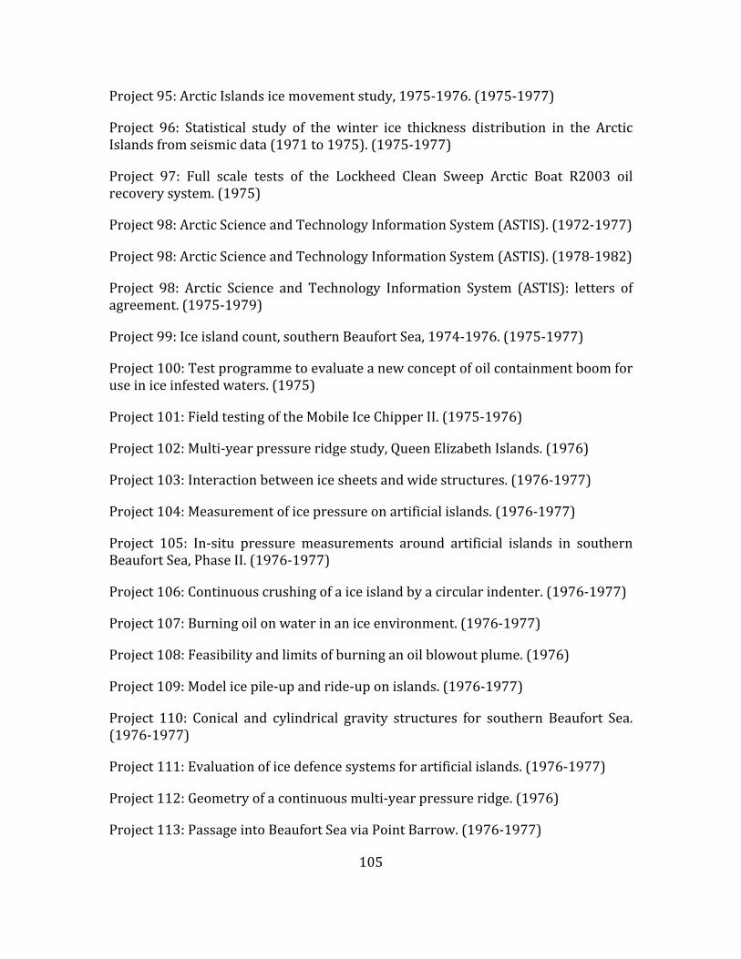
105
Project95:ArcticIslandsicemovementstudy,1975‐1976.(1975‐1977)
Project 96: Statistical study of the winter ice thickness distribution in the ArcticIslandsfromseismicdata(1971to1975).(1975‐1977)
Project 97: Full scale tests of the Lockheed Clean Sweep Arctic Boat R2003 oilrecoverysystem.(1975)
Project98:ArcticScienceandTechnologyInformationSystem(ASTIS).(1972‐1977)
Project98:ArcticScienceandTechnologyInformationSystem(ASTIS).(1978‐1982)
Project 98: Arctic Science and Technology Information System (ASTIS): letters ofagreement.(1975‐1979)
Project99:Iceislandcount,southernBeaufortSea,1974‐1976.(1975‐1977)
Project100:Testprogrammetoevaluateanewconceptofoilcontainmentboomforuseiniceinfestedwaters.(1975)
Project101:FieldtestingoftheMobileIceChipperII.(1975‐1976)
Project102:Multi‐yearpressureridgestudy,QueenElizabethIslands.(1976)
Project103:Interactionbetweenicesheetsandwidestructures.(1976‐1977)
Project104:Measurementoficepressureonartificialislands.(1976‐1977)
Project 105: In‐situ pressure measurements around artificial islands in southernBeaufortSea,PhaseII.(1976‐1977)
Project106:Continuouscrushingofaiceislandbyacircularindenter.(1976‐1977)
Project107:Burningoilonwaterinaniceenvironment.(1976‐1977)
Project108:Feasibilityandlimitsofburninganoilblowoutplume.(1976)
Project109:Modelicepile‐upandride‐uponislands.(1976‐1977)
Project 110: Conical and cylindrical gravity structures for southern Beaufort Sea.(1976‐1977)
Project111:Evaluationoficedefencesystemsforartificialislands.(1976‐1977)
Project112:Geometryofacontinuousmulti‐yearpressureridge.(1976)
Project113:PassageintoBeaufortSeaviaPointBarrow.(1976‐1977)

106
Project 114: Preliminary tests of bird‐scare devices in the Beaufort Sea. (1976‐1977)
Project115:Polarbearresearch.(1976‐1977)
Project116:Drillingfromshipsinshorefastice.(1976)
Project117:StatisticalstudyoflatewintericedistributionintheArcticIslandsfromseismicdata.(1976)
Project118:ArcticIslandswintericemovementstudy.(1976)
Project119:Remotedetectionofoilin/underice.(1976‐1977)
Project120:Safeicedetector:ProjectSID.(1976‐1979)
Project121:Multi‐yearpressureridgestudy,ArcticIslands.(1977)
Project122:In‐situicepressuremeasurements,1976‐1977.(1976‐1977)
Project123:Continuouscrushingofice,1976‐77.(1976‐1977)
Project124:Studyoficepile‐up.(1976‐1977)
Project125:ExperimentalridgeCRIinteraction,1976‐77.(1976‐1977)
Project126:BiologicalliteraturereviewofDavisStrait.(1976‐1977)
Project 127: Davis Strait winter biological sampling analysis and investigations.(1977)
Project128:DavisStraitpackicestudies,1976‐77.(1977)
Project129:DavisStraitoceancurrentmeasurementsandanalysis,1976.(1977)
Project130:DavisStraitstudiesofproductionstructures inthesouthernBeaufortSea.(1971)
Project 131: Feasibility study of a bottom mounted under ice profiling system.(1977)
Project132:Instrumentationofdrillingfluidsumps.(1977‐1979)
Project133:Investigationofsea‐bedscouringintheBeaufortSea,phaseIII.(1977‐1978)
Project134:Biologicalandoceanographicstudy,DavisStraitarea.(1977)

107
Project135:Biologicalsurveys,DavisStrait,1976.(1977)
Project 136: Shoreline study of Beaufort Sea, Komakuk Beach to Baillie Islands.(1977‐1978)
Project 137: Tests of ignition and herding devices for burning oil on ice [projectdeferred,seeProject141])
Project138:DavisStraitenvironmentalpropgram,secondhalf1977.(1977)
Project139:DevelopmentofanicemonitoringsystemintheBeaufortSea.(1977)
Project140:DavisStraiticepackincursionstudies,1977/78.(1977)
Project 141: Ignition and burning of crude oil on water pools under Arcticspringtimeconditions.(1977)
Project142:Statisticalstudyof latewintericethickness intheArctic Islandsfromseismicdata,1977.(1977‐1978)
Project143:Model experiments todetermine the forcesandbehaviourofmovingicefieldsagainstdrillingcaissons.(1977‐1978)
Project 144: Caisson retained island and ice ridge interaction studies, 1977/78.(1978)
Project145:Caissonretainedisland.(1978)
Project146:DavisStraitbiologicalprogramme.(1978)
Project147:IcekeelprofilingintheBeaufortSea.(1978‐1980)
Project148:Studiesofcontinuouscrushingofice[emptyfolder])
Project 149: Oilspill and iceberg studies conducted for an environmental impactstatementforDavisStrait.(1978)
Project150:Icescourmodeltests.(1978)
Project151:Analysisof1978BeaufortSeasidescansonarmosaics forrecentseabottomscouring.(1978)
Project152:Beaufortseawellcompletionsinpermafrost.(1978)
Project153:In‐situgashydratessurvey.(1978‐1979)

108
Project 154: High resolution ice tracking system: Beaufort Sea, Phases II and III:buoyconstructionanddeployment.[emptyfolder]
Project155:DavisStraitpackicecharacterization.[emptyfolder]
Project156:Iceislandstudies,1978‐79.(1979)
Project157:Tracemetalcharacteristicsinbaritefordrillingoperations.(1979)
Project158:BeaufortSearepetitivescourmapping,1979.[emptyfolder]
Project159:Portableoilburner.(1979)
Project160:Fireproofboomdevelopment.(1979)
Project161:Bacterialdegradationstudy.(1979)
Project162:Undericebubblertest.[emptyfolder]
Project163:Literaturestudyonbirddeterrenttechniques.(1979)
Project164:Airdeployableignitertests.(1979)
Project165:Airdeployableigniterimprovements.(1979)
Project166:In‐situcombustionofoilslicksagainstedges.(1979)
Project167:Mechanicaloilrecoverysystemsinice.(1979)
Project168:Polarbeardetectoranddeterrentdevices.[emptyfolder]
Project169:OilandgasunderBeaufortSeastudy.[emptyfolder]
Project170:InvestigationofgroundedrubblepilesintheBeaufortSea.(1979‐1981)
Project 171: Investigation of ice conditions and ice behaviour around Issungnak.(1980)
Project 172:Davis Straitweather/seastate buoy program and forecasting studies.(1980)
Project 173: Ecology of the southern Beaufort Sea andMackenzie River Delta: anannotatedbibliography.(1980)
Project174:Statistical studyof latewinter ice thicknessdistribution in theArcticIslandsfromseismicdata(1978‐1980).(1980‐1982)
Project175:Developmentofanicethicknessprofilerusingacoustics.(1980)

109
Project176:BeaufortSeaseismicitymeasurementprogram.(1980)
Project177:Icerubblemodeltests.([1980])
Project178:Bridge‐buildingmodeltests.(1980)
Project 179: Preliminary assessment of seismic forces and seismicity of theCanadianBeaufortSeaandpreliminaryinvestigationofpotentialbehaviourofsandislandsduringearthquakes.(1980)
Project180:IceforcesonHansIsland,1980.(1981)[Includesreport]
Project181:IceforcesonHansIsland,1981.(1981)
Project182:Videotapeof theCanadianBeaufortSeacoast fromtheAlaska/YukonbordertotheBaillieIslands.(1981)
Project 183:Beaufort Sea "GEOPOC" study (geotechnical evaluationof permafrostoncasings).(1982)
Project184:Low‐costside‐lookingairborneradarforseaicereconnaissanceintheBeaufortSea.(1981)
Project185:Naturalicerubblestudies.(1981)
Project186:Icerubblemodeltest,part2.(1981)
Project187:Surfacedisposalofdrillingfluidsinpermafrostregions.(1982)
Project188:Computer‐assistedlearningoilspillresponsetraining.(1981‐1984)
Project 189: Mitsui's Archimedean screw tractor (AST 002) in the CanadianBeaufortSea.(1981‐1982)
[Projects190‐195filesmissing]
Project196:Analysisofaccidentsinoffshoreoperationswherehydrocarbonswerelost.(1982)
Project197:TarsuitIslandresearchprogram.([1982])
Project198:TarsuitIslandresearchprogram,1982‐83.(1982)
Project199:Multi‐yearicefloesurvey,1982.(1982)
Project200:Multi‐yearicetestprogram.(1982)

110
Project201:Multi‐yearhummockfieldandfloe‐sizesurvey.(1982)
Project202:IceforcesonHansIsland.(1982‐1983)
[Project203filemissing]
Projects204‐211:BeaufortSeaproductionstrategicengineeringstudiesfor1983–forDomePetroleumLimited.(1982)
Project212:Dispersants:areasofapplicationfortheBeaufortSea.(1983)
[Project213filemissing]
Project214:Upward‐lookingiceprofilerstudy.(1983)
[Project215filemissing]
Projects216‐219:BeaufortSeaproductionstrategicengineeringprojectsfor1984–forDomePetroleumLimited.(1984)
[Project220filemissing]
Project221:Arcticescapesystem,phaseII.(1985‐1986)
[Project222filemissing]

111
Appendix D: Inventory of Canadian Centres OrientedtowardsNorthernResearch
D.1 ArcticNet
http://www.arcticnet.ulaval.ca/
Generaldescription:ArcticNetisaNetworkofCentresofExcellenceofCanadathatbrings together scientists and managers in the natural, human health and socialsciences with their partners from Inuit organizations, northern communities,federalandprovincialagenciesandtheprivatesector.TheobjectiveofArcticNetistostudy the impactsofclimatechangeandmodernization in thecoastalCanadianArctic.Over145ArcticNetresearchersfrom30CanadianUniversities,8federaland11 provincial agencies and departments collaborate with research teams inDenmark,Finland,France,Greenland,Japan,Norway,Poland,Russia,Spain,Sweden,the United Kingdom and the USA. ArcticNet is conducting Integrated RegionalImpactStudiesonsocietiesandonmarineandterrestrialcoastalecosystemsintheCanadianHighArctic,intheEasternCanadianArctic,andinHudsonBay.Inadditionto work conducted in northern communities, ArcticNet researchers from variousfields use the Canadian research icebreaker CCGS Amundsen to access the vastexpanses of the coastal Arctic. This integrated research offers a unique multi‐disciplinary and cross‐sectorial environment to train the next generation ofspecialists, from north and south, needed to manage the Canadian Arctic oftomorrow. The ArcticNet Administrative Centre is hosted at Université Laval,QuebecCity,Canada.
D.2 CentrefortheNorth(CFN)
http://www.centreforthenorth.ca/
TheCentre for theNorth isan initiativeof theConferenceBoardofCanada (CBC)thatbeganin2009.ThemandateofCBC,whichCFNfollows,isincludedbelow.Thegoal is to bring Aboriginal leaders, businesses, governments and communityadvocatestogethertoidentifychallengesandopportunitiesandtodecidehowthosechallengescanbemet.
Atpresent there is a staff of five: onedirector, three researchers andonegeneralstaffer.They:
delivercutting‐edgeresearchbasedonthreefoundationalthemesofthrivingcommunities, economic development and sovereignty and security in theNorth;
examine issues from a Northern perspective, seek to maximize Northernengagement,andprioritizeNortherninterests;

112
createuniquenetworkingopportunitieswithNorthernrepresentativesfromgovernment,industry,academiaandAboriginalgroups‐theonlyroundtableinCanadatoprovidethisbalancedmatrixofdialogue;
focus on delivering practical solutions to thewide ranging socio‐economicchallengesfacingCanada'sNortherncommunities;
covertheterritorialNorthaswellasthenorthernregionsofsevenprovinces;and
aresupportedbyaroundtableof50membersthatdetermineandreviewtheCentre'sresearchprojects.
CFNhasseveralmajorresearchprojectsunderway:
TheRoleofthePublicSectorinNorthernGovernance;
ConnectivityIssuesinCanada'sNorth;
AboriginalChildandYouthWellness;
EnergyinCanada'sNorth;and
ManagingtheImpactsofEconomicDevelopmentinNorthernMarineWaters.
ConferenceBoardofCanada
AboutCBC:
The foremost independent, not‐for‐profit applied research organization inCanada.
Objectiveandnon‐partisan.Wedonotlobbyforspecificinterests.
Fundedexclusivelythroughthefeeswechargeforservicestotheprivateandpublicsectors.
Experts in running conferences but also at conducting, publishing, anddisseminating research; helping people network; developing individualleadershipskills;andbuildingorganizationalcapacity.
Specialists in economic trends, as well as organizational performance andpublicpolicyissues.
Not a government department or agency, although we are often hired toprovideservicesforalllevelsofgovernment.

113
Independent from, but affiliated with, The Conference Board, Inc. of NewYork,whichservesnearly2,000companies in60nationsandhasoffices inBrusselsandHongKong
Mission: The Conference Board builds leadership capacity for a better Canada bycreatingandsharinginsightsoneconomictrends,publicpolicyandorganizationalperformance.
D.3 CanadianPolarCommission(GovernmentofCanada)
http://www.polarcom.gc.ca/principal/eng/content/contact‐us
Established in 1991, the Canadian Polar Commission has responsibility for:monitoring, promoting and disseminating knowledge of the polar regions;contributing to public awareness of the importance of polar science to Canada;enhancing Canada's international profile as a circumpolar nation; andrecommendingpolarsciencepolicydirectiontogovernment.
In carrying out its mandate, the Commission hosts conferences and workshops,publishesinformationonsubjectsofrelevancetopolarresearch,andworkscloselywithothergovernmentalandnon‐governmentalagencies topromoteandsupportCanadianstudyofthepolarregions.
TheCanadianPolarCommission'smandaterequiresitto:
monitorpolarknowledgeinCanadaandaroundtheworld;
workwithCanadianandinternationalinstitutionstodeterminescientificandotherpriorities;
encouragesupportforCanadianpolarresearch;
communicatepolarresearchinformationtoCanadians;and
fosterinternationalco‐operationintheadvancementofpolarknowledge.
D.4 CanadianHighArcticResearchStation(CHARS)
http://www.science.gc.ca/default.asp?lang=En&n=74E65368‐1
TheCanadianHighArcticResearchStation(CHARS)willprovideaworld‐classhubfor science and technology in Canada's North that complements and anchors thenetworkofsmallerregionalfacilitiesacrosstheNorth.ThenewStationwillprovidea suite of services for science and technology in Canada's North, including atechnology development centre, traditional knowledge centre and advancedlaboratories.

114
The Station will attract international scientists to work in Canada and willstrengthen Canada's leadership position in Arctic research. Northerners areengaging in cutting‐edge science and technology to address their needs in achangingNorth.ThisStationwillbebuiltbyCanadians,inCanada'sArctic,andwillbetheretoservetheworld.TheCanadianHighArcticResearchStationislocatedinCambridgeBay,Nunavut.
Objectives:
MobilizeArcticscienceandtechnology:
todevelopanddiversifytheeconomyinCanada'sArctic;
to support the effective stewardship of Canada's Arctic lands, waters, andresources;
tocreateahubforscientificactivityinCanada'svastanddiverseArctic;
topromoteself‐sufficient,vibrant,andhealthyNortherncommunities;
toinspireandbuildcapacitythroughtraining,education,andoutreach;and
toenhanceCanada'svisiblepresence in theArcticandstrengthenCanada'sleadershiponArcticissues.
Principles:
Address pressing issues in Canada's Arctic by conducting world‐classresearchanddeliveringexcellentandrelevantscienceandtechnology
Complement the network of Arctic expertise and facilities across Canada'sArcticandthewholeofthecountry
Promote partnerships and collaboration among the private, Aboriginal,academic,andpublicsectorsbothdomesticallyandinternationally
Work with Aboriginal peoples of Canada's Arctic and recognize theimportanceoftraditionalknowledgeinadvancingArcticresearch
Integrate across disciplines and across activities ‐ from problemidentification,throughresearchanddevelopment,tosolutions
Ensureeffectiveuseofdata, information,andtechnologythroughopenandtimelyaccessandknowledgeapplication
BeaworldleaderingreentechnologiesfortheArctic

115
Engineeringrelevance:theScienceandTechnologyPlanfor2015to2019hasbeenannouncedwithCallforProposlsontwothemes;thefirstisbaselinemonitoringofenvironmental and health factors, and the second on tools to use baseline data,takingintoaccoutnclimatechange,fordecisionmakinginthecontextofresoutrcedevelopmentfocusedonspecificgeographicareas.Theresultsoftheseprojectswillhaveengineeringapplication.
http://www.science.gc.ca/default.asp?lang=En&n=078AA8A0‐1
D.5 C‐CORE,LOOKNorth&CARD(centreswithinC‐CORE)
Established in 1975 as the Centre for Cold Ocean Resources Engineering toaddresschallengesfacingoil&gasdevelopmentoffshoreNewfoundland&Labradorandother ice‐proneregions,C‐COREisnowamulti‐disciplinaryorganizationwithworld‐leadingcapability in Remote Sensing, Ice Engineering and GeotechnicalEngineering.
HeadquarteredinCanadaatStJohn'sNL,withofficesinHalifax,OttawaandCalgary,C‐COREmaintainsaclosecollaborativerelationshipwithMemorialUniversity,withaccess to its extensive facilities, diverse academic expertise and $100 millionresearchportfolio.
C‐CORE is also home to LOOKNorth, a Canadian Centre of Excellence for remotesensing innovation to supportnorthernresourcedevelopment, and theCentre forArcticResourceDevelopment(CARD).
LOOKNorth:LOOKNorth is aCanadianCentreofExcellence forCommercializationand Research established by C‐CORE, an international leader in R&D for harshenvironments.HeadquartedinC‐CORE’sfacilitiesatMemorialUniversity(St.John’s,NL), LOOKNorth’s purpose,in collaboration with a broad network of industry,business and research partners, is tovalidate and commercialize remote sensing(RS) technologies that support responsible, sustainable resource development inCanada’sNorth.
LOOKNorth focuses onnatural resource industries (particularlyoil & gas, miningandhydro‐power),aswellasthetransportationsectorrelatedtothese. Itaimstoleverage RS technologies and derived data products/services that can provideinformationtoovercomeknowledgegapsandpositivelyimpactprojecteconomics,acceleratepermittingandimproveoperationalsafety.
CARD:TheCentreforArcticResourceDevelopment(CARD)servesasfocalpointforplanning, coordinating and conducting research to fill gaps in the knowledge,technology,methodologyandtrainingneededtoremovethesebarriers.TheCentrefocusesitseffortsonkeybarriersidentifiedbythebroaderresearchcommunityandvarioussectorsoftheoilandgasindustry.Itsresearchprogramsareorganizedintocore areas of IceMechanics, IceManagement and Station‐Keeping in Ice, and are
116
relatedthroughthecommonactivitiesofFloatingSystemModellingandLarge‐ScaleExperiments.
D.6 CanadianNetworkofNorthernResearchOperators
http://www.polarcom.gc.ca/index.php?page=canadian‐network‐of‐northern‐research‐operators‐cnnro
TheCanadianNetworkofNorthernResearchOperators(CNNRO)wasformedoverfiveyearsagotofacilitatecollaborationandtheexchangeofinformationamongallstakeholders who share an interest in infrastructure and logistics to supportresearchinnorthernCanada.
Its members meet annually to share best practices and help each other addresssomeoftheircommonchallenges.
Itsmain activities includemaintaining anon‐line registry of practical informationabouttheresearchfacilitiesandpromotingtheirservicestothenorthernresearchcommunity.
Engineeringrelevance:logisticsupportforfieldwork,couldcomplementPCSP
D.7 ArcticInstituteofNorthAmerica(atUofCalgary)
http://arctic.ucalgary.ca/
CreatedbyanActofParliamentin1945,theArcticInstituteofNorthAmericaisanon‐profitmembership organization and amulti‐disciplinary research institute oftheUniversityofCalgary.
The institute's mandate is to advance the study of the North American andcircumpolarArcticthroughthenaturalandsocialsciences,theartsandhumanitiesand to acquire, preserve and disseminate information on physical, environmentalandsocialconditionsintheNorth.
Engineering relevance: great store of documents, studies focussed mainly onenvironmentalandsocialscienceissue.
D.8 NRCArcticProgram
Work in progress; northern resource development (oil and gas), marinetransportationandhousing.

117
D.9 ProgramofEnergyResearchandDevelopment(PERD)
http://www.nrcan.gc.ca/energy/science/programs‐funding/1603
The Program of Energy Research and Development (PERD) is a federalinterdepartmentalprogramoperatedbyNaturalResourcesCanada(NRCan).PERDfundsresearchanddevelopmentdesignedtoensureasustainableenergyfutureforCanadainthebestinterestsofbothoureconomyandourenvironment.
PleasenotethatPERDonlyprovidesfundingtofederaldepartmentsandagencies.Itisnotageneralfundingorgrantprogramforcompanies,associationsorindividuals.
Thesedepartmentsandagenciesmaycollaboratewiththeprivatesectorandotherpublicandprivateagencies.
Offshore Environmental Factors: determine offshore environmental factors forregulatory,design,safetyandeconomicpurposes(EastCoastoriented).
Sub‐programs:
Wind&WaveHindcasting&Forecasting SeaIce&IcebergDetection&Forecasting OceanCurrentMeasurement&CirculationModelling Ice‐StructureInteractionResearch&StandardSetting SeabedStabilityResearch&Development
NorthernRegulatoryRequirements: Supports regulatoryprocesses andminimizesenvironmentalandsafetyrisksfornorthernoilandgasdevelopment.
Sub‐programs:
BiophysicalEnvironment EnvironmentalImpacts IceEngineering&Design
MarineTransportation&Safety:CarriesoutR&Dinaidofregulatoryrequirementsfor the safe and efficient transportation of oil and gas by tankers, and personnelsafetystandardsinoffshoreoperations.
Sub‐programs:
OffshorePersonnelSafety MarineOperations ShipSafety

118
RegulatoryRequirements forDrillingWastes&ProductionWaste;RemediationofAccidentalOffshoreDischargesandSpills
Sub‐programs:
DrillingWastes ProducedWater RemediationofAccidentalOffshoreDischargesandSpills
D.10 PolarContinentalShelfProgram(PCSP)
http://www.nrcan.gc.ca/earth‐sciences/products‐services/polar‐shelf‐services/11617
In accordance with Natural Resources Canada’s legislative authorities, the PolarContinentalShelfProgram(PCSP)coordinatesfieldlogisticsinsupportofadvancingscientificknowledgeandmanagementofCanada’slandsandnaturalresources.Asanational service delivery organization, PCSP coordinates logistics for Canadiangovernment agencies, provincial and territorial government agencies, northernorganizations,universitiesandindependentgroupsconductingresearchinCanada’sNorth,andthroughthiswork,PCSPdirectlycontributestotheexerciseofCanadianarcticsovereignty.
ThePolarContinentalShelfProgram’smissionistoprovidesafe,efficientandcost‐effective logistics services in support of Government priorities and economicprosperity.
D.11 BeaufortRegionalEnvironmentAssessment(BREA)2011‐14
http://www.aadnc‐aandc.gc.ca/eng/1310583424493/1310583559732
TheBeaufortRegional EnvironmentalAssessment (BREA) is a four year (2011 to2015),multi‐stakeholder initiative that is sponsoring regional environmental andsocio‐economic research to assist in preparing all parties, including the federalgovernmentandlocalcommunities,torespondtonewinvestmentsinoilandgasintheBeaufortSea.TheproposalwasinitiatedandissupportedbypartnersfromtheInuvialuit Settlement Region, territorial and federal governments, the oil and gasprivatesectorandacademia.
Throughmulti‐stakeholdercommittees,theBREAisbuildingaregionalknowledgebase to inform regulatory processes and project‐specific environmentalassessments related to oil and gas activity in the Beaufort Basin. This is beingachievedthroughtheimplementationofatargetedresearchprogramandworkinggroups that are addressing key regional issues including cumulative effectsassessment, information management, regional waste management, oil spillpreparednessandresponse,socio‐economicindicators,andclimatechange.

119
The initiative is aligned with the Northern Strategy and directly supports thepriorities of protecting our environmental heritage and promoting safe andsustainablesocialandeconomicdevelopmentinCanada’sNorth.
Formoreinformation,visit:www.BeaufortREA.ca
D.12 EnvironmentalStudiesResearchFunds(ESRF),CAPPsupported
http://www.esrfunds.org/abopro_e.php
Profile
The Environmental Studies Research Funds (ESRF) is a research program whichsponsorsenvironmentalandsocialstudies. It isdesignedtoassist in thedecision‐making process related to oil and gas exploration and development on Canada'sfrontierlands.TheESRFprogram,initiatedin1983,receivesitslegislativemandatethrough the Canada Petroleum Resources Act (CPRA), which was proclaimed inFebruary 1987. As well the Canada‐NewfoundlandAtlanticAccord ImplementationAct and the Canada‐Nova Scotia Offshore Petroleum Resources AccordImplementation Act provide legislative direction. The funding for the ESRF isprovidedthroughleviesonfrontierlandspaidbyinterestedholderssuchastheoiland gas companies. The ESRF is directed by a joint government/industry/publicManagementBoardandisadministeredbyasmallsecretariatwhichresidesintheOffice of Energy Research and Development, Natural Resources Canada, Ottawa,Ontario.
StructureandOperationoftheFunds
ThepurposeoftheESRFistofinanceenvironmentalandsocialstudiespertainingtothe manner in which and to the terms and conditions under which petroleumexploration, development, and production activities on frontier lands should beconducted. Frontier lands, defined as those areaswhere Canada has the right todispose of or exploit the natural resources, are situated in the offshore areas ofCanada'sEastandWestCoastsandtheareasnorthof60degrees.Environmentisinterpreted in the broadest possible sense and extends from the physicalenvironmentandbiologicalenvironmentissuestosocio‐economicissues.
The ESRF are directed by a 12‐member Management Board which hasrepresentation from the federal government (4), the Canada‐NewfoundlandOffshore PetroleumBoard (1), the Canada‐Nova Scotia Offshore PetroleumBoard(1), the oil and gas industry (4), and the general public (2). Robert Steedman,Professional Leader of Environment at the National Energy Board (NEB) is thecurrentchairmanof theESRFManagementBoard.TheESRF isadministeredbyasmallsecretariatwithinNaturalResourcesCanada.

120
The ESRF Management Board takes a hands‐on approach to the conduct of thebusiness of the ESRF. On behalf of the Minister of Natural Resources and theMinisterof IndianAffairsandNorthernDevelopment, theManagementBoardsetspriorities for study topics, determines the program budget, and facilitates thedevelopment of study proposals. The ESRF provides a forum for industry andgovernment todevelopacommonknowledgebaseandto jointlydesigna focusedstudyprogramwhichaddressestheneedsofbothgroupsandavoidsarepetitionofeffortandexpense.
The program operates on a calendar‐year basis. The Management Board hastraditionally met on a semi‐annual basis; however, the frequency of meetings isadjustedascircumstancesdictate.TheManagementBoardassessestheinformationrequirementsofgovernmentandindustrytodeterminestudysubjectprioritiesforwhichastudyprogramforthecomingyearisdeveloped.Thebudgettosupportthestudyprogramandadministrativecostsformthebasisforthecalculationofthelevyrate schedule. The budget and levy rates are submitted to the Ministers forapprovalby1Novemberof eachyear.Theprojectsunder the studyprogramareinitiated following the collection of the levies, which generally occurs in the firstquarterofthecalendaryear.

121
AppendixE:ReviewofRecentReports
The focusof thereport isengineering inCanada’snorthernoceansandwaters. Inorder to deal with this adequately, there is a chapter on northern resources, asmining activities will almost inevitably require access by sea. In the same vein,reviewsinthepresentsectionincludeaspectswhichareland‐basedyetarerelevanttonortherndevelopment,suchasroadandrail.
E.1 CFNChangingTides:EconomicDevelopmentinCanada’sNorthernMarineWaters(Fournier,S.andCaron‐Vuotari,M.,2013)
ThereportemphasizesthatCanada’snorthernmarinewatersrepresentoneoftheworld’s last natural resource frontiers. Development will hinge on four factors:climatechange,infrastructure,emergencyresponseandSAR,andcommodityprices.ItsummarizesrenewedinterestinoilandgasexplorationintheBeaufortSea,andrecentoffshorelicensesindeeperwatersinBeaufortSea.
With regard to climate change, the report considers that this will improve theaccessibility of northern marine waters. It does emphasize spatial and temporalvariation of temperature changes. For example, the western Canadian Arctic hasseen temperatures rise by asmuch as 2.2° C over the past 50 years, almost 1° Chigherthantheaverageincreaseforthecountryasawhole.Theaverageincreaseintemperature in Canada has been above global averages. The strongest warmingtrendsbetweenwereinthefarNorthofCanada.ReferringtoFigureE.1,theseweretheArcticTundra,ArcticMountainsandFjords,MackenzieDistrict,andYukonandNorth British Columbia climatic regions. Some areas saw little increase intemperature.
In the past few decades there has been an increase in overall shipping trafficthroughout Canada’s Northern marine waters, especially since 2006. Naturalresources activity, particularly mining projects, is partly responsible for theincrease,asareresupplyservicestoNortherncommunities.Buttourismandfishingactivitiesarealsoplayingarole.
Lessiceduetowarmingmeansincreasedaccessibilitywithregardtoshipping.Thesituationiscorrectlydescribedas“complex.”Changestothetypeoficethatwillbefound in Northern waters are important. Old ice may be present. Powerful ice‐breakersare required to penetrate and navigate throughmulti‐year ice,whereaslessrobustvesselscanoperateinfirst‐yearice,althoughthisicemaybecomeridgedandmoredifficulttopenetrate.
An important impact is permafrost reduction, occurring in parts of Yukon, theBeaufort and Mackenzie regions of the Northwest Territories, and the regionsurroundingJamesBayonthewestsideofHudsonBay.Shorterwintersandhigher

122
average temperatureswill reduce theamountof time that ice roads can safelybeused,witha reduction in the lengthof the transportationwindow.This canmeansignificantlossesforimpactedindustriesandcommunities.Iceroadshavebecomeincreasingly unreliable over the past few decades in certain parts of the North.Permafrostreductioncanaffectraillinesandtheuseofrailroadsmaybecomelessattractivethanmarinetransportation.
Currently, the infrastructure in and around Northern Canadian waters is notsufficientforbroad‐basedeconomicdevelopment. TheonlydeepwaterportintheArctic at present is at Churchill, Manitoba. One is planned by the CanadiangovernmentforNanisivik,expandingthefacilitydevelopedfortheNanisivikmine.Search‐and‐rescue(SAR)facilitiesalongwithdisasterresponsecapabilityareseentobeinadequate.
Development of industry and commercial enterprises can be a driver for thedevelopment of facilities. A boom‐and‐bust issue is associatedwith this: facilitiescan be built for a particular development, used, and then not remain (or not besuitable)forcommunityuse.
The report gives examples of approved and plausible projects in Canada’s Northinclude:
ThepubliclyfundedMackenzieall‐weatherhigh‐wayinN.W.T.thatwouldconnecttheportatTuktoyaktuktoInuvikand,ultimately,toWrigley;
Government of Canada investment in a refuelling and docking station formilitary and coastguard vessels (although originally intended as a moreexpansivedeepwaterportfacility)atNanisivik;
PossibleprivatesectorinvestmentinadeepwaterportandroadattheheadofBathurstInletforminingoperations(zincandgold)intheregion.
Port of Churchill could see its role expanded through the provision ofservicestocommunitiesandminingoperationsalongtheKivalliqcoastandinmeetingfreightdemandsforNunavutingeneral.
Conclusionstothereportaresummarizedasfollows:
A need for greater collaboration and integration with respect to decision‐makingandgovernanceon issuesrelevant toeconomicdevelopment in themarine waters of Canada’s North. By sharing knowledge and expertise,stakeholders can remove or reduce incomplete information as well ascapacityconstraints.

123
Leveraging public and private sector resources for infrastructure projects,for instance, isonewayofaddressing the infrastructuredeficit inCanada’sNorth. Similarly, infrastructure projects should try to be leveraged so thattheytargetmultipleobjectives.
Uncertaintypresentsaproblemthathastobedealtwith.
Emphasis on safety and safety culture in northern development.“Northerners,governments,andindustrymustemphasizeriskreductionandbuildingacultureofsafetyinallareasofpotentialeconomicdevelopment.”
“ThewaythattherisksandbenefitsofeconomicdevelopmentareweightedandmanagedmustmakesensetoNortherners,keeptheirinterestsfrontandcentre,andeffectivelycapturetheNortherncontext.”

124
FigureE.1:ClimaticRegionsofCanada

125
FigureE.2:OilandgasinCanada’sterritorialwaters.

126
FigureE.3:OilandgasoffcoastofLabrador.
E.2 CFN Northern Assets: Transportation Infrastructure in RemoteCommunities(Bristow,M.andGill,V.,2011)
AgeneralpointismadethattransportationinfrastructureinNortherncommunitiesissignificantlymoreexpensivetodevelopthanintheSouth.AtthesametimefailureofinfrastructureintheNorthcanresultinbaregrocerystoreshelvesordisruptionfromemergencymedicalservices.TransportationinfrastructureinCanada’sNorthissparse.
Theeffectsofclimatechangearediscussed,which iscausing temperatures torisemore quickly in the North than in other regions of Canada. In permafrost zones,foundations are engineered to rest upon frozen ground. Warming temperaturescause areas of discontinuous permafrost to move further north, with regions ofthawing permafrost. The result is “ground slumping, tilted trees, sinkholes, andotherdisturbances”,alongwithdecliningviabilityofwinterroads.
This can have a significant impact on Northern communities and resource

127
development projects that rely on winter roads. Typically, these roads are usedbeginninginNovemberorDecemberandareviableuntilMarchorApril,butmilderwinters are disrupting this schedule.25 In cases where the only other option isairlift,thisresultsinasignificantincreaseinthecostofsupplies.All‐weatherroadsoffer an alternative for future construction. Figure E.3 shows the current roadinfrastructureinCanada.
Investmentsareoftenrequiredforprojectsthatarenotseenasbeingeconomicallyjustifiedbutwhicharevitalforeconomicandcommunitydevelopment.Benefit‐costanalysesfortheseprojectsmustcaptureafullrangeofeconomicandsocialbenefitsunique toNortherncommunities.Thereport correctlyadvocates thiskindof tool,benefitcostanalysisthatacknowledgesallbenefits.Northerncommunitiesthatrelyonasinglemainindustrymaybeconfrontedwithdifficultiesifthatindustrywindsdown. This is the “boom‐and‐bust” scenario mentioned in the “Changing Tides”reportsummarizedabove.
Marinetransportofferstheleastexpensivetransportationmethodforfreightandisusedfortransportingfuel,groceries,andothercommercialfreighttotheNorthwestTerritories,Nunavut,andtheNorthernregionsofprovinceswithtidewateraccess.Atthesametime,thereisverylittlemarineinfrastructureintheNorth,andalmostnoneinNunavut.Cargoisoftenoffloadedontobeaches,andaccesstotheselandingsitescanbeunpredictable.Themarineshippingseasonisshort,rangingfromonetofivemonths,dependingonthelocationofthecommunity.
It is noted that Baffinland IronMines Corporation is planning to build a 143‐kmrailway,adeep‐seaport, andanairstrip toservice itsMaryRiver ironoreminingproject.
ThereportconsidersacasestudyofChurchill,Manitoba.Thisportisnotconnectedto the road system in NorthernManitoba, but has access to air, rail, andmarinetransportation,airandrailbeingavailableyear‐round.ChurchillisalsothehometoCanada’s only operatingdeepwater port in theArctic region,making it a possibleshippinghubfortheFarNorth.AnumberofkeyissuesintheChurchillcasestudyprovidedbackgroundfordevelopmentinotherNortherncommunities.Substantialfunding is often required for ongoing operating and maintenance. Full life‐cyclecosts are important. Public resources are already scarce, and inventive solutionsthat target themost cost‐ effectivemeansof achievingeconomicandsocialpolicyobjectivesareneeded.
It is advocated to consider traditional and alternative financial arrangements,including public‐private partnerships. Both public and private interests could beservedbytransportationinfrastructureprojectsintheNorth.
Thedesign,construction,andoperationofnewtransportation infrastructuremustincludemeasuresthataccountforthepotentialeffectsofclimatechange.Itisstated
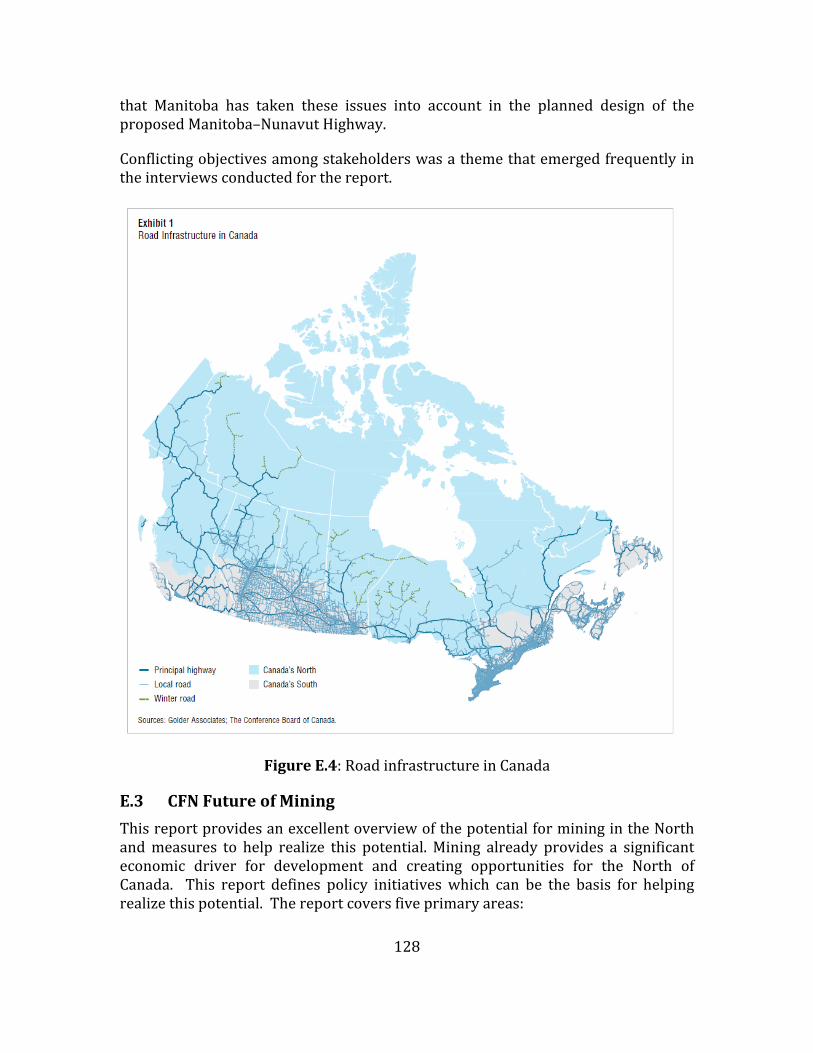
128
that Manitoba has taken these issues into account in the planned design of theproposedManitoba–NunavutHighway.
Conflictingobjectivesamongstakeholderswasathemethatemergedfrequentlyintheinterviewsconductedforthereport.
FigureE.4:RoadinfrastructureinCanada
E.3 CFNFutureofMining
ThisreportprovidesanexcellentoverviewofthepotentialforminingintheNorthandmeasures to help realize this potential.Mining already provides a significanteconomic driver for development and creating opportunities for the North ofCanada. This report defines policy initiativeswhich can be the basis for helpingrealizethispotential.Thereportcoversfiveprimaryareas:

129
Canada’snorthernminingpotentialtotheyear2020 businessfactorsrelatedtominingdevelopment impactsandbenefitsofminingfornortherncommunities addressingenvironmentalstewardshipandtheimpactsofmining creatingasustainablefuture:whathappensafteraminecloses?
andconcludeswithsixkeyrecommendations.
MiningisseenasafutureeconomicdriverofCanada’sNorth.Thelong‐termglobaldemand for commodities is increasing, even if there are short‐term swings, andCanada is well positioned to take advantage of this opportunity. The overallNorthernmetallicmineral output is about $4b annually,with about $1b from theYukon, Northwest Territories and Nunavut. This is expected to almost double by2020.Thereisalsoabout$1/2bspentannuallyinthethreenorthernterritoriesformineral exploration. World markets are not controlled by Canada, but there arefactorswhicharewithinCanada’scontrol.Thispotentialcanberealizedonlyifkeyregulatory, infrastructure, and human resource challenges are met. All factorsnecessary for mining development must be looked at in a holistic fashion.Governments,industry,andAboriginalgroupsneedtocoordinatetheirefforts,andmusthavebetterknowledgeoftheirrolesandresponsibilitiestobeeffectiveandtoavoidduplicationofprocesses.
Regulatoryprocessesarecurrentlycomplexandcumbersome,andlackclarityandconsistency for all proponents. For example, many project review boards do nothavethecapacitytoensureprojectreviewsarecompletedinatimelymanner.Thispresentssignificantobstacles for investors.Thisreportrecognizesthat thefederalgovernment has taken important steps toward the “one project, one assessment”goal,andthatthiscouldleadtogreatercooperationandcoordinationbetweenthefederal and provincial/territorial governments. However, Aboriginal governmentsneed to be full and equal participants in decision‐making. Challenges still remainwithrespecttotherealizationoflandclaimsandself‐governmentagreementsandtheirroleinresourcemanagementanddevelopment.
TheinfrastructuregapsareoftenthegreatestdeterrentstominingdevelopmentinCanada’s remote Northern regions. Many companies must build their owntransportation, communication, and/or energy infrastructure, adding significantcosts to projects. To ease this financial burden on industry, governments need toinvest broadly in Northern infrastructure and make use of public‐privatepartnershipstosharerisks,costs,andbenefits.
Theminingindustryworldwideisfacinganimpendinglabourshortage,andCanadaisnotimmunetothis.YoungerCanadiansfromallbackgroundsareignoringminingas a career option. Therefore,mining companiesmustwork to recruit and retainnew workers and look to under‐ represented groups—such as women, new

130
Canadians, and Aboriginal Peoples—as potential sources of labour. Additionally,education and targeted training programs are needed to ensure that localpopulationsareabletobenefitfullyfromemploymentopportunities.
Companies and governments need to begin consultation processes as early aspossibleinordertoprovidecommunitieswiththetoolsnecessarytomakeinformeddecisions.Whilethisisstronglyrecommended,companiesarenotobligatedtodoit.However, mechanisms like impact and benefit agreements (IBAs) can beinstrumental in ensuring that a community’s needs are met and properlyaccommodated.Furthermore,ongoingconsultationthroughoutallphasesofminingactivity—from exploration to mine closure—helps build and foster positiverelationships.
Improved regulations, industry‐led initiatives, technological innovations andtraditional ecological knowledge have all contributed to improving the industry’senvironmental performance. Companies have also worked to minimize theirimpactsontheland,andmineclosureandremediationhavecomealongwaysincemining’s early days. Despite all of this, many important environmental concernsremain,particularlyaroundtheuncertaintiesofthelong‐termimpactsofminingonfloraandfauna.
Mining projects can deliver immediate benefits to residents in the form of jobs,higher incomes,businessopportunities,and infrastructure.However,communitiescanbeunpreparedformineclosure.Robustclosureplansshouldbeinplacetohelpdiversify the local economy, especiallywhen the community is reliant on a singleresource. Mining companies, governments, and local communities should worktogetherattheoutsetofaprojecttoprovidesolutionsthatwillmitigatetheimpactsofclosure.
Each issue presents its own unique challenges and requires solutions andrecommendedactionsinitsownright.Lookingattheseissuestogether,thefindingsofthisreportsuggestthefollowingpriorityareasforpolicydevelopmenttosupportthefutureofsustainablemininginCanada’sNorth:
acompetitivebusinessenvironmentfortheminingindustry, addressinginfrastructuregapsandneeds, recruitment initiatives aimed at women, new Canadians, youth, and
Aboriginalworkers, meaningful community consultations and ensuring the implementation of
Aboriginallandclaimsandresourcedevelopmentagreements, improving regulatory processes and personnel turnover in government
regulatorybodies,and furtherinvestmentsingeoscience.

131
E.4 CCA Northern Ocean Science in Canada:Meeting the Challenge,SeizingtheOpportunity
Recognizing the importance of ocean science, the Canadian Consortium of OceanResearchUniversities(CCORU)askedtheCouncilofCanadianAcademies(CCA) toundertake an assessment of the state of ocean science in Canada. The reportwascarried out by an expert panel formed by the Council of Canadian Academies(CouncilofCanadianAcademies,2013).
Canada’sexisting researchcapacitywas investigated.ThestateofCanada’sageingresearchfleetwasnoted.Canada’soutputofoceansciencewasconsideredtobeinthetoprankatpresent,butatrisk.Fundingopportunities,forinstancethoseofferedby the Canada Foundation for Innovation, are enabling the establishment andmanagement of large‐scale infrastructure. This includes vessels and observationnetworks.ConsortiasuchasCCORU,areemerging.Thesenetworksandalignmentshave resulted in several innovative, world‐leading initiatives. Despite theseadvances, the Panel identified the gaps in the coordination and alignment of theoceansciencecommunityinCanada.Theprincipalrelatetolackofanationalvisionfor ocean science, and of effective national‐level mechanisms to coordinateresources and sharing of infrastructure and knowledge among ocean scientists.Finally, an information gap is perceived: a mechanism or repository thatsystematicallycollectsandregularlyupdatesinformationonkeyresearchactivitiesinoceansciencefortheentirecountryisneeded.
E.5 True North: Adapting Infrastructure to Climate Change inNorthernCanada
Thisreportwascarriedoutby theNationalRoundTableon theEnvironmentandtheEconomy(2009).
By means of research and extensive consultation of stakeholders, the risks tonorthern infrastructure posed by climate changewas investigated togetherwithopportunities for adaptation. The recommendations were primarily addressed togovernment and were focussed on adaptation to climate change and the use ofcurrent and future policy and decision‐making processes to this end. Buildingnortherncapacitytoadapttoclimatechangewasaprimemotivation.
E.6 ArcticMarineShippingAssessment(AMSA)2009(ArcticCouncil)
TheArcticCouncil in2004commissionedaworkinggroup toprepare the subjectreport.Thereportdealswithclimatechange,Arcticmarinetransport,governanceofArctic shipping, current marine use, future scenarios, human and environmentalconsiderations, as well as infrastructure. Natural resource development(hydrocarbons,hardmineralsandfisheries)andregionaltradewereseenasthekeydrivers of futureArcticmarine activity. A lack ofmajor ports, except for those innorthern Norway and northwest Russia, and other critical infrastructure poses

132
significantdifficultiesforfutureArcticmarineoperations.Destinationalshippingisemphasized.ManyArcticresidentsdependonmarineresourcesforsubsistenceanditissuggestedthatconstructiveandearlyengagementoflocalresidentsinplannedArcticmarinedevelopmentprojectswillbebeneficialtotheirwell‐being.
Thereportiscommendableintermsoftherangeandthoroughnessofitscoverage.Recommendationsweremade on arcticmarine safety, protection of arctic peopleand the environment, and building arctic marine infrastructure. Of particularinterest are that the Arctic states should support the development andimplemention of a comprehensive,multi‐national Arctic Search andRescue (SAR)instrument,andthattheArcticstatesshouldcooperateinthedevelopmentofArcticmarineinfrastructure.
E.7 FromImpactstoAdaptation;CanadainaChangingClimate2007
ThisreportwassponsoredbyNaturalResourcesCanadaandEnvironmentCanada(Lemmen et al., 2008). Its focus is on changing climate, and adaptation to thischange. The report points out that adaptive capacity in Canada is high, but thatresource‐dependent and Aboriginal communities are particularly vulnerable toclimatechanges.ThisvulnerabilityismagnifiedintheArctic.
E.8 The Past is Always Present: Review of Offshore Drilling in theCanadianArctic(NationalEnergyBoard,2011)
Same‐season relief well issue is covered. Regarding thismatter, NEB affirmed itsintent toretain itssame‐seasonreliefwellpolicy.But thereportalso includedthestatement that “an applicant wishing to depart from our policy would havetodemonstratehowtheywouldmeetorexceedtheintendedoutcomeofourpolicy.Itwould be up to usto determine, on a case‐by‐case basis, which tools areappropriate.... We acknowledge that there is a continual evolution of technologyworldwide, including the technologyneeded to kill an out‐of‐controlwell.We areopentochangingandevolvingtechnology.”
E.9 CARDArcticDevelopmentRoadmap(CARD,2012)
ThisreportisfocusedontheOilandGasindustries.Aspartofitsplanningprocess,the Centre for Arctic Resource Development (CARD) developed the “ArcticDevelopment Roadmap” (CARD, 2012). The importance of this document for thepresentCAEstudy is that, inorder todevelop theroadmap,aseriesof interviewswereconductedwiththemajoroilandgasoperatorsandconsultantsinordertogettheir perspectives. The oil and gas operators who were interviewed includedExxonMobil, Suncor, Husky Energy, Statoil, Chevron, Imperial Oil, Shell andConocoPhillips.AppendixQQlistspastplanningstudiesofrelevancetotheCanadianArctic.

133
AppendixF:PreviousPlanningstudies(OilandGas)
TableF.1listssomeearlierR&DplanningstudiesforCanada’sArcticoilandgas.TheTableisreproducedfromCARD(2012)andiscontainedintheir“Roadmap”whichisdiscussedinthereport.
TableF.1:PaststudiesonArcticoilandgasdevelopment

134

135
AppendixG:NaturalResources
G.1 Sources
The Future ofMining in Canada’s North, by Gilles Rhéaume andMargaret Caron‐Vuotari,TheConferenceBoardofCanada,ReportJanuary2013.
G.2 Preface
Mininganditssupportingindustrieswillcontinuetobeimportanteconomicdriversinmany of Canada’s Northern regions over the course of the next decade.Whilegreatpotentialforminingdevelopmentexists,thispotentialmustbeapproachedina balancedway. This report discusses a number of important factors— and theirinterrelationshipwith one another—thatmust be considered to ensure that boththe positive and negative impacts of mining projects are fully understood. Thefindingsfromthisreportprovidepolicy‐makers,industryleaders,andcommunitieswithinsightonstepsthatcanbetakentosupportthefutureofsustainablemininginCanada’sNorth.
NunavutMineralExploration,MiningandGeoscienceOverview2012,MineralsDivisionatAboriginalAffairsandNorthernDevelopmentCanada’sNunavutRegionalOffice.
http://www.nrcan.gc.ca/earth‐sciences/resources/federal‐programs/geomapping‐energy‐minerals/10904
G.3 GEM:Geo‐MappingforEnergyandMinerals
Researcherswith Natural Resources Canada’s (NRCan’s) Geo‐mapping for Energyand Minerals (GEM) Program are providing their geo‐scientific expertise to helprealize this potential. The goal is to improve regional geological mapping in thenorthforresponsibleresourceexplorationanddevelopment.
“Thisinformationishelpingnorthernerstomakeinformedchoicesonlandusethatbalance conservation with development of northern resources,” says DonnaKirkwood,DirectorGeneral,CentralandNorthernCanadaBranch,GeologicalSurveyofCanada,NRCan.
G.4 GEMtheNextPhase
The secondphase of theGEMprogramwill be used to further develop geologicalmaps, data sets and knowledge. The new knowledge and data will completeregional‐scale coverage of Canada’s North by 2020, focusing on areas of highresourcepotential.

136
Asnewgeo‐mapsareproduced,theyaremadepubliclyaccessibleon‐lineandfreeofchargetoindustryinvestors,land‐useplanners,andcommunityagencies.
“We are alsoworkingwith provincial and territorial governments and Aboriginalorganizations, as well as seeking advice from northerners in implementing thisprograminordertomaximizethebenefitsfornortherners,”addsDonnaKirkwood.
TableG.1:OilandGasResources
Region CrudeOil (MillionBarrels) NaturalGas (TCF)
106m3 109m3
NorthwestTerritoriesandArcticOffshore 187.9 1182.5 457.6 16.2
NunavutandArctic 51.3 322.9 449.7 16ArcticOffshoreYukon 62.5 393.8 4.5 0.2Total 301.7 1899.1 911.8 32.4
TableG.2:NorthwestTerritories
Mine Owner Commodity Basicfacts Latestdevelopments
EkatiMine BHPBilliton,ChuckFipkeandStuBlusson
Diamonds Canada’sfirstandlargestdiamondmine,310km.NEofYellowknife.Openpitandunderground.Minelifeto2019.Workforceapproximately1,500
2011YearinReviewreportreleased.BHPBillitonisconductingreviewofdiamondsbusinessandpotentialsale.
DiavikMine RioTintoandHarryWinston
Diamonds Canada’slargestdiamondproducer,300kmNEofYellowknife.Openpitandunderground,butwillbeallundergroundin2012.Minelifeto2023.Workforceapproximately1,000.
OnemilliontonneundergroundproductionreachedinMay.Minelifenowconfirmedto2023withproductionfromadditionalpipe,calledA21.RioTintoisconductingreviewofdiamondsbusinessandpotentialsale.
SnapLakeMine
DeBeers Diamonds Canada’sfirstallundergrounddiamondmine.Located220kilometresNEofYellowknife.Minelifeto2028.Workforceapproximately678.
CommencedcommercialproductiononJanuary16,2008andtheofficialmineopeningtookplaceonJuly25,2008.

137
Mine Owner Commodity Basicfacts Latestdevelopments
CantungMine
NorthAmericanTungsten
Tungsten,copper
CantungisinthemountainsofwesternNorthwestTerritories,approx.300kmbyroadNEofWatsonLake,Yukon.Minelifeto2014.Approximately200jobs.
Junenewsreleasereportssignificantnewundergroundexplorationresultsin“AmberZone.”
Nechalacho AvalonRareMetals
Rareearthmetals
Proposedundergroundmine100kmSEofYellowknife.Estimatedminejobs:200NechalachoprojectatThorLake,located100kmsouthestofYellowknife.
Avalonsubmittedresponsesto2ndroundofinformationrequeststotheenvironmentalimpactreviewboardforenvironmentalassessment.Avalonsigned1stof3agreementswithequityparticipationwiththeDeninuK’ueFirstNation
NICO FortuneMineralsLtd.
Cobalt‐goldbismuthcopper
Proposedopenpitandundergroundminelocated50kmNEofWhati.Estimatedminejobs:150
Environmentalpublichearingshaveconcluded.
YellowknifeGoldProject
TyheeGoldCorp
Gold Proposedopenpitandundergroundmineof4depositsabout90kmNEofYellowknife.Estimatedminejobs:238
PositivefeasibilitystudyannouncedAug.15,submittedtoReviewBoardaspartofactiveenvironmentalreview.
PrairieCreek
CanadianZincCorporatoin
Lead‐zincsilver
Proposedundergroundmine120kmwestofFortSimpson.Estimatedminejobs:220
Projectinpermittingandlicensing.PreliminaryFeasibilityStudyresultsissuedJune27.
GahchoKue DeBeers&MountainProvince
Diamonds Proposedopen‐pitdiamondmineapproximately180kmENEofYellowknife,NT.Estimatedminejobs:360
PublichearingdatesforEnvironmentalImpactReviewfinalizedforNov.30‐Dec.8inDettah,LutselK’e,&Yellowknife.
PinePoint TamerlaneVentures
Lead‐zinc CompanyproposesundergroundmineeastofHayRiverusingfreezetechnologyforwatermanagement.Estimatedminejobs:225
CompanyhasrequestedchangetoauditanddeclinefromshafttotestminetheR‐190deposit.Resourceisdefined;permittedforconstruction;extensiveinfrastructure
CourageousLake
SeabridgeGold
Gold Proposedopenpitmine240kmnortheastofYellowknife
PositivePreliminaryFeasibilityStudyreleasedJuly24with6.5millionouncesprovenandprobablereserves.Explorationbudgetof$8.5millionthisyear.AnnualreportreleasedinMay.

138
Mine Owner Commodity Basicfacts Latestdevelopments
SelwynProject
SelwynChihong
Zinc,lead ProposedundergroundmineinYukononNWTborderandaccessisthroughNWT.AgreementssignedwithNWT(Sahtu)Aboriginallandcorporations
Feasibilitystudytobedonethisyear.ResourceupdatedinAugustandsurpasses180milliontonnes.InearlySept,SelwynsuspendeditsStrategicReviewProcessasitcontemplatedtheeffectsof"theworsteconomictimesinrecentmemory"andpotentialsaleoftheproject.
TableG.3:Nunavut
Mine Owner Commodity Basicfacts Latestdevelopments
MeadowbankGoldMine
Agnico‐EagleMines
Gold Open‐pitminelocatedintheKivalliqRegion,300kmwestofHudsonBayand70kmNofBakerLake.Minejobs:450
NTIreceivedfirstroyaltypaymentin2012.Julysecondquarterreportsrecordquarterlygoldproductionof98,403ounces
MaryRiver BaffinlandIronMines
Iron Proposedopenpitminewithrailwayandport936kmNofIqaluitwith5knowndeposits.Estimatedconstructionjobs:3,500Estimatedminejobs:715
FinalhearingsforenvironmentalassessmentcompletedinJuly2012.NIRBhasgrantedapprovaloftheprojectwith184conditionstobemet.
Kiggavik AREVAResources
Uranium Proposeduraniummine80kmWofBakerLake.EstimatedConstructionjobs:750Estimatedminejobs:1,300
ArevaanticipatessubmittingresponsestoitsDraftEnvironmentalImpactStatement,totheimpactreviewboardbyJan.31,2013.
JerichoDiamondMine
ShearDiamondsLtd.
Diamonds Projecttoreassessviabilityofreopeningtheformerdiamondmine,255kmSSEofKugluktuk.Estimatedminejobs:150‐200
Shearsuspendsstockpileproductionduetolowdiamondprices,Sept.4,2012
MeliadineGold
Agnico‐EagleMines
Gold Possiblegoldmine,5deposits,thelargestofwhichistheTiriganiaqdeposit,25kmNEofRankinInlet.Estimatedconstructionjobs:600Estimatedminejobs:350–400
Plantocompletefeasibilitystudyin2013;NIRBapprovedenvironmentalassessmentexemptionof“Phase1–all‐weatherRoad”onMay23,2012.RoadlocatedonInuitOwnedLand.

139
Mine Owner Commodity Basicfacts Latestdevelopments
HackettRiver
XstrataZincCanada
Zinc,silver,copper,leadandgold
OneoflargestundevelopedVMSmassivesulphidedepositsintheworld,hostingsignificantsilverdeposits.104kmSSWofBathurstInlet.Estimatedminejobs:300
CampopenedFeb.20,2012,Pre‐feasibilitystudyteambeingassembled.
BackRiver SabinaGold&SilverCorp.
Gold Approximately60kmfromHackettRiver.Potentialtominemultipledepositsbyopenpitandunderground.Workforceupto900.
Explorationbudgetfor2012hit$60M.ProjectdescriptionsubmittedtoNIRBinJulytotriggerEA.
IzokCorridorProject(withHighLake)
MMGResourcesInc.
Copper,Zinc,Gold,Silver
IzokandHighLakeESEofKugluktuk.PlanscallforsingleprocessingfacilityatIzok,350kmall‐seasonroadtoportatGray’sBay.ShippingtoEuropeandAsia.Totaljobs710with400onsite.
OnSept.4,MMGsubmittedprojectproposaltoNIRBtotriggerofficialenvironmentalassessmentprocess.
Ulu&Lupin ElginMiningInc.
Gold LocatedSEofKugluktuk.Lupinmine:pastproductionof3.7millionounces.Uludeposit:indicatedmineralresource:751,000tonnesat11.37gramsofgoldpertonne.
ElginpurchasedbothpropertiesfromMMGResourcesinJuly,2011.WinterizationofworkcampatLupinDrillingatUlubeganApril2012.
RocheBay AdvancedExploration
Iron Over500milliontonnesofindicatedresourceswithin6kmofanaturaldeep‐waterharbouratRocheBay.Estimatedconstructionjobs:450Estimatedminejobs:370–380
PositivefeasibilitystudyannouncedAug.10,2012,confirmsnetpresentvalueof$642million(pre‐tax)
Chidliak PeregrineDiamondsLtd.
Diamonds Located180kmSofPangnirtung.Contains59knowndiamond‐hostingformations.
PeregrineannouncedpotentialjointventureagreementwithDeBeers,Sept.5,2012.
DorisNorth/HopeBay
NewmontMiningCorp
Gold Proposedgoldmines130kmSofCambridgeBaycoversthemajorityoftheHopeBayGreenstoneBelt.Estimatedminejobs:300
Workpostponedindefinitelywhileprojectunderreview

140
AppendixH:ListofwellsdrilledinCanadianBeaufortSea
TableH.1:ExplorationwellsdrilledintheCanadianBeaufortSeabydateandplatformtype(fromCallow,2012)

141

142
AppendixI:MineralsandOilandGasMap