Embed Size (px)
Citation preview
Enfield Local Heritage List
www.enfield.gov.uk
May 2018

May 2018 2
Introduction
The following introduction describes the purpose of the Local Heritage List, how it has been prepared and its place in the planning process.
Local listing is a means for a community and a local authority to jointly identify heritage assets that are valued as distinctive elements of the local historic environment.
Local heritage assets are defined as buildings, structures and sites which have special local interest, but which are not included in the national list of buildings of special architectural or historic interest, or in the national register of historic parks and gardens.
The list provides clarity on the location of the asset, and its special qualities, ensuring that strategic local planning properly takes account of the desirability of their conservation.
Inclusion on the list means that the conservation as a heritage asset is a material consideration when deciding on planning applications.
The previous Local List was prepared in 1974 and had been added to over the years. Enfield Council in partnership with the Enfield Society and local communities has reviewed the Local List for the Borough.
The list has been developed in accordance with Historic England best practice guidance. A Local Heritage Review Board, convened from stakeholders across the project (including The Enfield Society, Enfield Conservation Advisory Group, Local History Officers, Historic England and a Volunteers representative) evaluated the survey data collected by the volunteers for compliance with the agreed selection criteria.
Public consultation on the draft list took place between September and November 2016 and the new list was approved by Cabinet in September 2017.
There are 261 entries. They fall into a number of different asset types, including dwelling houses, shops, banks, public houses, factories, utilities (e.g. telephone exchanges, postal sorting offices), structures (railway bridges, street furniture, post boxes etc.), parks / gardens and cemeteries, schools, libraries and places of worship. The entries are in alphabetical order by address.
The list was updated in May 2018 to include the addition of this introduction page and correct typographical issues.
Enfield Council especially wishes to acknowledge the support and assistance received from The Enfield Society in the preparation of the list.
Further information can be found on the Council’s website:https://new.enfield.gov.uk/services/planning/heritage-conservation-and-countryside/listed-buildings/
Enfield Borough’s Local Heritage List

May 2018 3
Photograph Asset Details Description
1 Address:1 and 3 Abbey Road, Bush Hill Park, Enfield EN1 2QPSignificance:Architectural Quality, Urban DesignAsset Type:Dwellinghouses
These two early buildings are associated with the second phase of development by the Bush Hill Park Estates. Company between 1896 and 1914; The second phase of building consists of attractive detached and semi detached houses, influenced by the Arts and Crafts style and built of brown stock brick, with red brick dressings, steeply pitched tiled roofs, tall prominent chimneys decorated with over-sailing courses and timber sash windows. Façades tend to be informal, often with offset gables and irregularly spaced windows. In the Conservation Area character appraisal these two houses are identified as making a particular contribution to the area. These two dwellings have distinctive features including dog tooth woodwork on prominent front gables, patterned brickwork and tiles; No 1 has prominent castellated features along the roof line.
2 Address:1 to 17 (odd)Abbotshall AvenueN14 7JUSignificance:Rarity, Architectural Quality, Group ValueAsset Type:Dwellinghouses
A group of five detached and four semi detached houses. Constructed between 1934 and 1936 (shortly after the extension of the Piccadilly line which opened at Arnos Grove in 1932). Good example of the Art Deco/Moderne style, with flat roofs, curved projecting front bays and porch canopies and horizontal metal framed windows. Projecting bands on front elevation, carried around on the flank elevations. Built as one coherent development except No13, which is of a different fundamental design, but nonetheless of interest.
3 Address:HSBC Bank (No 1)Aldermans Hill, Palmers GreenN13 4YESignificance:Rarity, Historical Association, Architectural Quality, Aesthetic MeritAsset Type:Bank
High quality late C19/early C20 bank building standing in a prominent location looking onto ‘The Triangle’ in Palmers Green. The building stands head and shoulders above the surrounding terrace and forms a dramatic centerpiece to that composition. The building is symmetrically arranged with 5 bays of windows on the upper floors. At ground floor, the frontage retains the original banded brickwork and there are two side door cases with stone pediments over. At first floor level, the window openings have banded arches with keystone features. At roof level, the building has an ornate pediment feature with central occulus window, prominent banded chimney stacks and visible glazed lantern to central roof.
May 2018 4
Photograph Asset Details Description
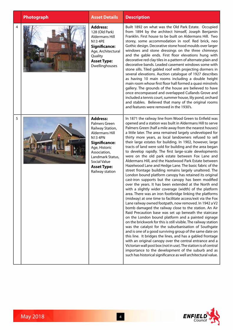
4 Address:128 (Old Park)Aldermans HillN13 4PESignificance:Age, Architectural QualityAsset Type:Dwellinghouses
Built 1892 on what was the Old Park Estate. Occupied from 1894 by the architect himself, Joseph Benjamin Franklin. First house to be built on Aldermans Hill. Two storey, some accommodation in roof. Red brick, neo Gothic design. Decorative stone hood moulds over larger windows and stone dressings on the three chimneys and the gable ends. First floor elevations hung with decorative red clay tiles in a pattern of alternate plain and decorative bands. Leaded casement windows some with stone sills. Tiled gabled roof with projecting dormers in several elevations. Auction catalogue of 1927 describes as having 10 main rooms including a double height main room whose first floor hall formed a quasi minstrels gallery. The grounds of the house are believed to have once encompassed and overlapped Cullands Grove and included a tennis court, summer house, lily pond, orchard and stables. Believed that many of the original rooms and features were removed in the 1930’s.
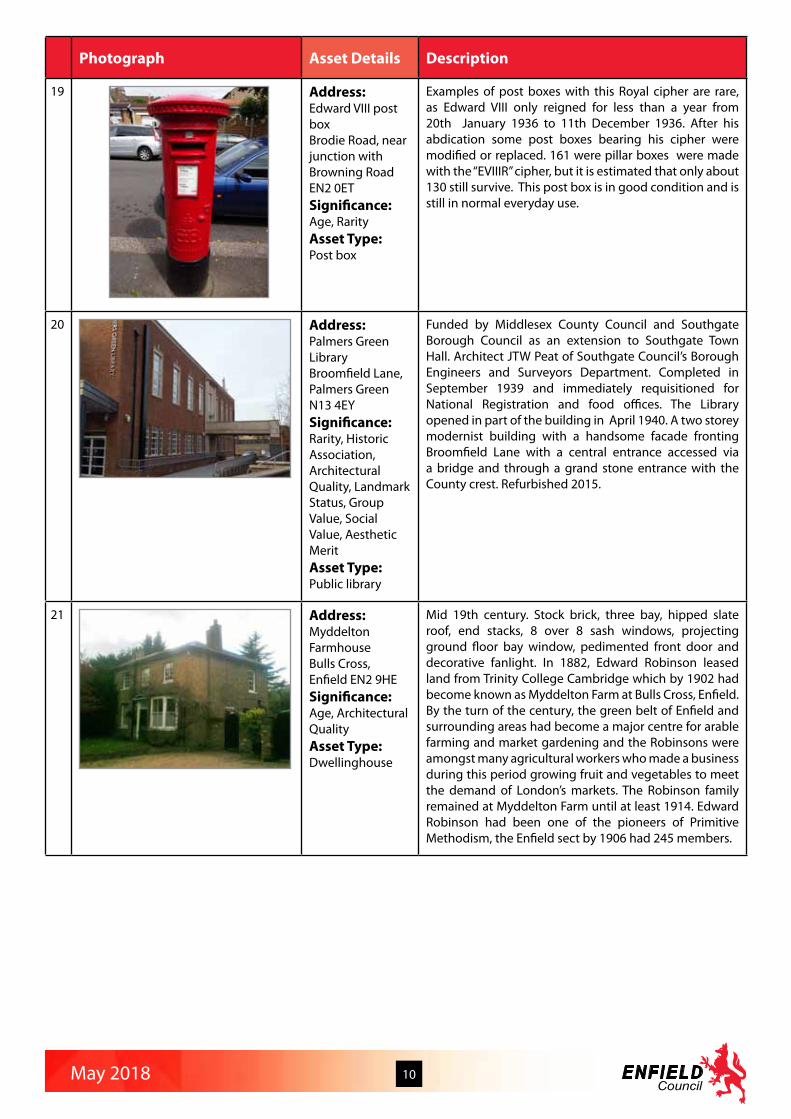
5 Address:Palmers Green Railway Station,Aldermans HillN13 4PNSignificance:Age, Historic Association, Landmark Status, Social ValueAsset Type:Railway station
In 1871 the railway line from Wood Green to Enfield was opened and a station was built in Aldermans Hill to serve Palmers Green (half a mile away from the nearest houses) a little later. The area remained largely undeveloped for thirty more years, as local landowners refused to sell their large estates for building. In 1902, however, large tracts of land were sold for building and the area began to develop rapidly. The first large-scale developments were on the old park estate between Fox Lane and Aldermans Hill, and the Hazelwood Park Estate between Hazelwood Lane and Hedge Lane. The basic fabric of the street frontage building remains largely unaltered. The London bound platform canopy has retained its original cast-iron supports but the canopy has been modified over the years. It has been extended at the North end with a slightly wider coverage (width) of the platform area. There was an iron footbridge linking the platforms (midway) at one time to facilitate access/exit via the Fox Lane railway owned footpath, now removed. In 1942 a V2 bomb damaged the railway close to the station. An Air Raid Precaution base was set up beneath the staircase on the London bound platform and a painted signage on the brickwork for this is still visible. The railway station was the catalyst for the suburbanisation of Southgate and is one of a good surviving group of the same date on this line. It bridges the lines, and has a gabled frontage with an original canopy over the central entrance and a Victorian wall post box (not in use). The station is of central importance to the development of the suburb and as such has historical significance as well architectural value.

May 2018 5
Photograph Asset Details Description
6 Address:Air Raid Shelter Broomfield Park,Aldermans Hill, Southgate N14Significance:Age, Rarity, Historic Association, Archeology ValueAsset Type:World War 2 air raid shelter
A brick built World War II air raid shelter with reinforced concrete roof. Single storey with water tanks above. Built to support the Auxiliary Fire Service at Broomfield House. Part of the air raid shelter is believed to have been converted into a chemical decontamination unit in the event of gas attacks. Later converted into changing rooms. An unusual remnant of Southgate’s war heritage.
7 Address:173 Alma Road, Ponders End, Enfield EN3Significance:Age, Rarity, Architectural Quality, Social ValueAsset Type:Vacant (originally public house)
Prominently located mid-19th century building with many original features and layout, including sash windows, leaded fenestration, mullions, dormers, corbels and brackets. The naming of the former pub and road a reminder of action in the Crimean War, one of the opening conflicts was the Battle of Alma 1854. Records in Gary Boudier’s history of Enfield pubs record it from the mid nineteenth century. The then landlord, John Saunders, was repeatedly before the bench as a repeat offender, for not admitting police, assault, being open after hours and theft. The public bar remained until 1987 when it became Chesters restaurant.
8 Address:Hitch Mylius, Alma House (No 301)Alma Road, Enfield EN3 7BBSignificance:Architectural Quality, Aesthetic MeritAsset Type:Factory office building
1950s industrial building restored in 1995. Ground floor windows possibly by Haywards of Lincoln Road, Enfield. The glass manufacturers established a factory at Enfield in 1921. They specialised in prismatic pavement lights. Ceased trading in the 1970s. Hitch Mylius appointed architects, the Pike Practice, to transform it into a modern factory and showroom (featured in Architects’ Journal, September 1995). The move enabled the workforce to double in size, providing employment opportunities for the Enfield area.
9 Address:Anne Crow’s Almshouses,Almshouse LaneEN1 4QESignificance:Age, Rarity, Historic Association, Architectural Quality, Group ValueAsset Type:Dwellinghouses
A terrace of four one-bedroomed bungalows just off Turkey Street, owned by the Old Enfield Charitable Trust. These houses are let to needy residents of the Ancient Parish of Enfield. Built in 1893 by H. C. B. Bowles of Myddelton House. - Treasures of Enfield p.37. Brick with steep tiled roof, big central chimney and half timbered gables. Replaced original houses built on this site for the parish poor in the late 17th Century and latterly owned by Thomas Crowe.

May 2018 6
Photograph Asset Details Description
10 Address:Hop Poles Public HouseBaker Street and Lancaster RoadEN2 0JSSignificance:Age, Historic Association, Architectural Quality, Landmark Status, Social ValueAsset Type:Public house
The “Hop Poles” was built in 1910 on the site of an earlier public house of the same name dating from the 1850s. It’s distinctive architecture provides a good local landmark at a busy road junction. It is still in use as a pub at a time when many local pubs are closing. The land on which the Hop Poles is built originally belonged to the owners of the Forty Hill Estate. This was leased, in 1774, to a carpenter named Joseph Matthews who built a house and workshop. The property remained in the hands of his descendants and in 1852 it was converted into a ‘public victualling house’ with a carpenters shop adjacent. Peter Rumney, of Smith and Postans, wine and spirit merchants, was the publican and it is possible that it was during this period that the name ‘The Hop Poles’ was adopted. Sixteen years later, James Winkworth, a wheelwright became the publican but he appears to have borrowed heavily and on the death of his widow in 1895, the premises were bought by Truman, Hanbury and Buxton for £9,650. Enfield Libraries have reproduced a picture postcard of the Hop Poles corner in 1890 looking north along Baker St The public house had a plastered facade with plain sash windows and a board showing the brewers as Truman, Hanbury and Buxton. The Hop Poles was rebuilt in 1910 as a result of a road widening scheme, and was intended to be an excellent example of what a public house should be. The new Hop Poles was built by Patman’s of Enfield Town at a cost of £3,960. The publican was Charles Archibald Fairlie who came from Dover. The license was to be held by a member of the Fairlie family until comparatively recently. With a change in ownership, there was an attempt to change the name to the Enfield Stores, but the name “Hop Poles” was eventually kept and is still in use. The building externally largely retains its 1910 appearance.
11 Address:The Rosary, North Enfield Conservative Club (No 278)Baker Street, Enfield EN1 3LDSignificance:Age, Historic Association, Social ValueAsset Type:Former Dwellinghouse
The North Enfield Conservative Club occupies The Rosary house, built in 1763 and in 1910 leased to the Conservative Club. The club was formed by a group of local business men headed by Colonel Henry Ferryman Bowles of Forty Hall. A lounge extension in 1953 was opened by Ian Macleod MP. The hall, snooker room and offices were opened in 1971 by Sir Donald Karberry MP.

May 2018 7
Photograph Asset Details Description
12 Address:Jolly Butcher’s Public House (No 168)Baker Street, Enfield EN1 3JSSignificance:Age, Architectural Quality, Landmark Status, Social Value, Aesthetic MeritAsset Type:Public house
The Jolly Butchers pub is an unusually elegant building with turrets and well decorated outside with plasterwork embellishment between the first and second floors. ‘1906 by William Stewart, still has fine exuberance of the turn of the century, roughcast gables, plaster frieze and twin domed turrets formerly flanking a central carriageway.’( The Buildings of England - London 4: North’ by Bridget Cherry and Nickolaus Pevsner)
13 Address:The Wonder PubBatley Road, Enfield EN2 0JGSignificance:Historic Association, Architectural Quality, Social ValueAsset Type:Public house
First recorded as a public house in 1838 with the first landlady, Mary Pinnock, the present building dates to the Late Victorian/Early Edwardian period. It is a traditional two bar pub. It is constructed of red brick with a tile roof and seems to have the original chimneys. The eaves project over the walls and the end walls supporting the roof are in the Tudor style. It has sash windows in groups of three and four on the first floor and transommed windows on the ground floor, most are original. In 1862 the pub is recorded as two cottages owned by the Lucena family. During the 1860’s the pub was known as the Little Wonder with the sign depicting a race horse. In 1840 a horse called the Little Wonder had won the Derby at odds of 40 to 1. Over the years many fights took place outside the pub, these mainly took place on the green opposite, and were known as ‘blood tub’ fights and Batley Road was known locally as blood alley. The pub is valued locally for its charitable activities and for supporting elderly customers. The pub hosts bands on a regular basis and Dave Peacock of Chas and Dave has played here. The pub was purchased from the Lucena family by Peter McMullen in 1877. McMullens Brewery was founded in 1827 by Peter McMullen and since then the family have continued to run the business and brew the beer in Hertford. In 1910 McMullen & Sons Limited was one of 1,284 brewing companies
14 Address:Hadley WoodGolf ClubBeech Hill, Hadley Wood EN4 0JJSignificance:Historic Association, Designed LandscapeAsset Type:Golf course
Beech Hill Park, built by Francis Russell on the former Enfield Chase, is now used by Hadley Wood Golf Club as their club house. The estate was sold off for housing in the 1880s by the then owner Charles Jack. After Jack’s death the house remained empty for many years before being leased to Hadley Wood Golf Club and converted into a golf course in 1922. Fish ponds that had once stood on the Chase remain in the grounds. The club house is Grade II listed.

May 2018 8
Photograph Asset Details Description
15 Address:Claysmore LodgeBeggars Hollow, off Clay Hill, Enfield EN2 9JLSignificance:Age, Architectural QualityAsset Type:Dwellinghouse
Claysmore Lodge is an attractive 19th century single storey dwelling, built in 1803 according to the date on the gable end. It was once part of the large Clayesmore estate. Around 1810 Mr Edward Harman purchased the Clayesmore estate and improved the property. In April 1829 he exchanged two dwellings next to the Greyhound public house, now Barclays Bank in Enfield Town, for two cottages at Bull Beggars Hollow in Clay Hill, one of which is thought to be Clayesmore Lodge, which still stands today.There is some evidence that Clayesmore Lodge (now called Claysmore Lodge) was fitted out as a private chapel for Sunday afternoon services, where one of the curates preached to a congregation of sometimes 60 people. However the part used as a chapel was destroyed by fire., although the rest survived. In 1847 Edward Harman went bankrupt and James Whatman Bosanquet of the Bosanquet banking empire moved into Clayesmore. Mr Bosanquet died in 1877. It appears that the estate was then let on an annual basis, first in 1878 to Mr Charles Holland and then in 1882 by Bernard Tindal Bosanquet, the son of James Whatman Bosanquet. Upon the passing of Bernard Bosanquet, the estate was purchased by Sir Frederick Orr Lewis, the owner of neighbouring Whitewebbs estate. In 1896 Alexander Devine moved into the mansion and founded Clayesmore as a preparatory school for boys. In 1900 a junior boarding school was added and a number of temporary buildings were erected to accommodate the extra pupils. After the school left in 1902, the estate went into decline and the high cost of maintaining the large estate made it difficult to find tenants. In 1904, there is a record of it being used as a sanatorium, but a year later, Nicholas Bosanquet was living there. In 1911 it was owned by the Ritter family. In 1937, the house and the outbuildings were demolished and the land sold in pieces. In the 1950s, a Mr Stevens bought part of the estate and built a new house, which is now called Brayside Farm. The Lodge survived and is currently a private house maintained in excellent condition externally.
16 Address:The Woodman Public House(No 128) Bourne Hill N13 4BD and Southgate Animal PondSignificance:Age, Landmark Status, Social ValueAsset Type:Public house
Built around 1727, originally as two rustic small cottages now conjoined and enlarged. Whilst living at The Woodman in 1868, retired policeman, Henry Wale, asked the local magistrates if he could have permission to sell ale from his front sitting room. Henry Wale became the first licensee of The Woodman. The building has remained a public house ever since. A rear bar and conservatory were added in 1996, when the pub was refurbished. The original buildings remain relatively unchanged externally. Forms a group with the Southgate Animal Pound opposite, as the landlord was often the Keeper of the Pound. It is a prominent building, particularly when approaching from the east along Bourne Hill.

May 2018 9
Photograph Asset Details Description
17 Address:The Ritz Parade (inc. Jehovah’s Witness building)Bowes Road, London N11 2JGSignificance:Architectural Quality, Landmark Status, Urban DesignAsset Type:Cinema, shops and flats
Well-preserved Art Deco building from 1933, know as the Ritz Parade, with a Jehovah’s Witnesses Assembly Hall is at its centre . It was built and designed by Major W.J. King as one of several Ritz Cinemas planned for a small chain, the project was sold to Associated British Cinemas (ABC) prior to completion. It opened as the ABC Ritz Cinema on 21st December 1933 with Douglas Fairbanks Jr. in “The Narrow Corner” and John Wayne in “His Private Secretary”. It is now the JW North London Assembly Hall. The auditorium runs parallel to the main Bowes Road (which today is part of the North Circular Road around London) and was hidden from view by a parade of shops. Inside the auditorium, the main features were a central dome in the ceiling and abstract decorative designs on the splay walls each side of the proscenium.
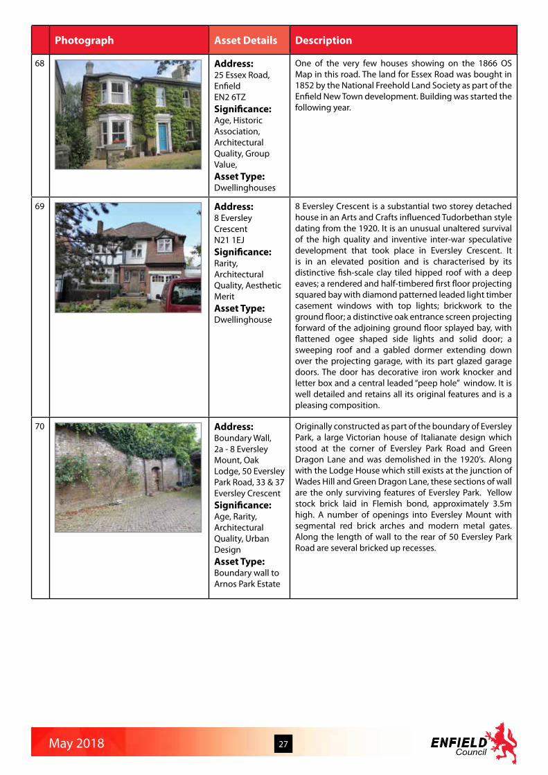
18 Address:Brettenham Road Primary SchoolBrettenham Road, Edmonton N18Significance:Age, Architectural Quality, Landmark StatusAsset Type:School
Brettenham Primary School was the first Edmonton School Board School, built in 1882 and enlarged 1885-89. The staff room is a fine, late Victorian, room which was once the headquarters for the Edmonton School Board. It contains an imposing chair, dais and name boards of the School Board members. The architect Henry William Dobb is mentioned in connection with the building of The Greyhound in Earls court, 1899, from the firm Borer and Dobb George Borer was the architect of the Sandringham Buildings mansion block in Shaftesbury Avenue of 1883 for the improved industrial dwellings company. Henry Dobb was married in Edmonton in 1882, (b. Rotherham 1858) where he died aged 77 in 1936. In 1881, Dobb was a boarder with the said George Borer at Church Villas , Church Street, Edmonton - so no doubt a pupil of the latter. Borer died in 1886 aged 47, and Dobb continued the practice at 99 Church Street, Lower Edmonton (now N9) . In 1886 he was at 110 London Wall, EC. Borer was Architect and Surveyor of the IIDC. A temporary board schools for boys, girls, and infants opened in 1881. The boys occupied Elm House, a former private school in Fore Street near the junction with Brettenham Road, until 1882. The girls used the Wesleyan Sunday school in Fore Street until 1893 (fn. 63) and the infants used the mission room in Dyson’s Road. The first permanent board school opened in Brettenham Road in 1882 with boys from Elm House. There were boys’, girls’, and infants’ departments until after the Second World War, when the boys and girls were amalgamated as a junior mixed school. The yellow-brick building was enlarged in 1885, 1887, 1889, and 1892 (fn. 64) and numbers rose from 892 in 1888 (fn. 65) to 1,235 in 1906, thereafter dropping until 1973, when there were 301 in the junior school and 250 in the infants’.
May 2018 10
Photograph Asset Details Description
19 Address:Edward VIII post boxBrodie Road, near junction with Browning RoadEN2 0ETSignificance:Age, RarityAsset Type:Post box
Examples of post boxes with this Royal cipher are rare, as Edward VIII only reigned for less than a year from 20th January 1936 to 11th December 1936. After his abdication some post boxes bearing his cipher were modified or replaced. 161 were pillar boxes were made with the “EVIIIR” cipher, but it is estimated that only about 130 still survive. This post box is in good condition and is still in normal everyday use.
20 Address:Palmers Green LibraryBroomfield Lane, Palmers GreenN13 4EYSignificance:Rarity, Historic Association, Architectural Quality, Landmark Status, Group Value, Social Value, Aesthetic MeritAsset Type:Public library
Funded by Middlesex County Council and Southgate Borough Council as an extension to Southgate Town Hall. Architect JTW Peat of Southgate Council’s Borough Engineers and Surveyors Department. Completed in September 1939 and immediately requisitioned for National Registration and food offices. The Library opened in part of the building in April 1940. A two storey modernist building with a handsome facade fronting Broomfield Lane with a central entrance accessed via a bridge and through a grand stone entrance with the County crest. Refurbished 2015.
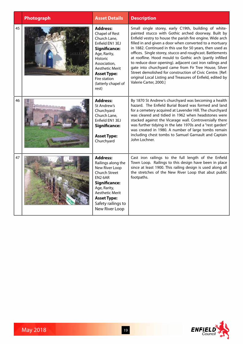
21 Address:Myddelton FarmhouseBulls Cross, Enfield EN2 9HESignificance:Age, Architectural QualityAsset Type:Dwellinghouse
Mid 19th century. Stock brick, three bay, hipped slate roof, end stacks, 8 over 8 sash windows, projecting ground floor bay window, pedimented front door and decorative fanlight. In 1882, Edward Robinson leased land from Trinity College Cambridge which by 1902 had become known as Myddelton Farm at Bulls Cross, Enfield. By the turn of the century, the green belt of Enfield and surrounding areas had become a major centre for arable farming and market gardening and the Robinsons were amongst many agricultural workers who made a business during this period growing fruit and vegetables to meet the demand of London’s markets. The Robinson family remained at Myddelton Farm until at least 1914. Edward Robinson had been one of the pioneers of Primitive Methodism, the Enfield sect by 1906 had 245 members.

May 2018 11
Photograph Asset Details Description
22 Address:Capel ManorBullsmoor Lane, Waltham CrossEN1 4RQSignificance:Historic Association, Designed LandscapeAsset Type:Gardens
William Capel’s medieval manor house stood somewhere near Bulls Cross. The present house was built in the mid 18th century and in 1793 was acquired by Rawson Hart Boddam on his return from India where he had been Governor of Bombay. In 1840 the house was bought by James Warren, a wealthy tea merchant. The last private owner was Lt Col Sydney Medcalf who had a keen interest in horticulture and horses. Enfield Council acquired the estate and gardens in 1968 and opened them as an agricultural college. Themed gardens have been created by the college to trace the history of gardens and gardening.
23 Address:Newbury SiteBury Street, London N9 7JRSignificance:Architectural Quality, Landmark Status, Social Value Asset Type:Hall (now Enfield Secondary Tuition Centre)
Originally Bassishaw Hall, built in the early 1900s of red brick with a fine, imposing frontage. Original, detailed windows. Original porch and chimney stacks.
24 Address:Bury Lodge GardensBury Street West, Edmonton, N9 9JNSignificance:Designed Landscape,Social ValueAsset Type:Public gardens
Bury Lodge Gardens is an ornamental public park laid out by Edmonton UDC between 1935-7 on the grounds of Bury Lodge, a house dating from medieval times, which was demolished in 1936. The Recreation Ground, which also took part of the grounds of the adjacent Salisbury House, was opened on 10 April 1937. The original layout, which is largely intact, had a rose garden planted with 4,700 roses with a central lily pond and pergolas, a sheltered retreat for the elderly, an open-air draughts board, and a pool for paddling and sailing model boats. There were also slides, swings and a merry-go-round, and grass plot for games. Along the southern boundary is Salmon’s Brook and to the east, behind Salisbury House, is a bowling green.
25 Address:The Lodge (No 14)Bush Hill, London N21 2DASignificance:Age, Rarity, Historic Association, Architectural Value, Landmark StatusAsset Type:Dwellinghouse
The Lodge is a small two storey dwelling set in quite a large plot, with a steep roof and room for accommodation in the roof. It appears to be in good condition with interesting detailed tiling on the front walls, and Tudor like tall chimney with broadercourses at the top. The Lodge is not in it’s original condition, with the front door facing the road having been blocked in with a wooden (possibly pantry) like structure by the turn of the nineteenth/twentieth century. The two metre high boundary wall has been considerably reduced to the present low brick wall.

May 2018 12
Photograph Asset Details Description
26 Address:Green Ridges (No 23) Bush Hill, London N21 2BTSignificance:Rarity, Architectural Quality, Landmark StatusAsset Type:Dwellinghouse
Green Ridges is the only one of its kind, certainly in the locality, and its very distinctive design and unusual brightness together with its prominent position on the wide bend on the hill of Bush Hill make it very visible and therefore a landmark building. It has not been possible to find out the architect, but it is likely it was built in the 1930s after the depression; it doesn’t show on the Survey map of 1914 but like most of the houses in Bush Hill, it shows on the map of 1956. The design has strong International influence from Dutch and Spanish styles and is a pastiche of Art Deco merging into Modernism. Green Ridges almost appears to be inspired by Hollywood with a combination of forms borrowed from different styles; its clean white walls and distinctive green tiles, which enjoyed some popularity at this time, particularly along parts of the South Coast. It manages to combine the straight lines from the Bauhaus movement with an almost Arts and Crafts style prominent capped front gable, with slight Dutch style curve to the roof line. Then the green tiles add a Spanish touch which were seen combined with Art Deco style which also embraced white walls and curves. Finally a symmetrical distribution of different window designs works well; the main square windows with smaller octagonal porthole like ones and a semi-circular shape in the central landing window.
27 Address:Pedulas (No 1) Cannon Hill, Southgate N14 and boundary wall between Nos 1 and 3 Cannon Hill (including part of 1 & 1a Minchenden Crescent) N14 Significance:Age, Rarity, Historic Association, Architectural Quality, Landmark Status, Aesthetic MeritAsset Type:Dwellinghouse
A large double fronted detached arts and craft style house built in 1929 on part of the Arnos House estate. An attractive entrance porch with balcony above, red brick with mock tudor timberwork and herring bone brickwork panels. Sympathetically extended to the north elevation, with a rebuilt substantial garden wall in keeping with the original design.

May 2018 13
Photograph Asset Details Description
28 Address:Bush Hill Park Golf Club and stable building south west of clubhouseCarrs Lane, Winchmore Hill, London N21 2BUSignificance:Age, Rarity, Historic Association, Architectural Quality, Landmark Status, Social ValueAsset Type:Former Dwellinghouse
Bush Hill Golf Club. Opened in 1895 on the old Home Park of Enfield Manor from where 397 oak trees went to the Navy in the Great War. The Golf Club House entrance is partly from 1705. The building is in red brick, extended in 1893 and there are 18th stables with clock turret. It was built by the Clayton family and later belonged to the 19th antiquarian Edward Ford, who collected a number of items which included two 15th heads which were once displayed on the stables; and three carved 15 figures of saints. The original house was the Rangers Lodge for Enfield Chase. The club house stands on the site of an Iron Age camp. This consisted of a single rampart built of packed earth and riveted with timber, and a ditch beyond it. It is the largest hill fort in Middlesex and has a huge breadth of view around the whole area and beyond. In the east part is a modern pond, fed by a spring which would have been inside the fort, and ensured a water supply. The car park covers a lake which was to the west of the house. Near the house are three Cedars of Lebanon, one of which was planted in 1846 and was a sapling from the first such cedar planted in Britain in the 16th. There is a Holm Oak at the back of the house with branches so long they have split from the trunk. There is an American Swamp Cypress in the car park, another nearer to Bush Hill and another near the brook – which has soft spongy growths which provide the roots with air. In front of the house is an American Sweet Gum and there are also lots of yew trees around.
29 Address:Enfield Central Library, Cecil Road, Enfield EN2 6TWSignificance:Age, Rarity, Historic Association, Architectural Quality, Landmark Status, Urban Design, Social ValueAsset Type:Public library and public open space
Carnegie Library in the Edwardian or English baroque Style of red brick with stone dressing. There were many Carnegie Libraries built in the United Kingdom and several of these were in the English or Edwardian Baroque Style. Most of these seem to have been built around 1905 whereas Enfield’s is later at1912. Apart from the provision of the funds by Mr Carnegie it appears to have been an “all Enfield affair” as it was designed by the Architect Richard Collins who was the Surveyor to the District Council, the Council’s Building Inspector John Parham acted as Clerk of Works and the building company of Messrs Fitch & Cox based in Baker Street carried out the work. There is a full account of the opening of the library giving information about how it was financed and who was involved in the project and the opening ceremony in the Enfield Observer of 19th July 1912. Many Carnegie Libraries, including those in Edwardian Baroque style have been listed (e.g. Bridgewater 1905 and Herne Hill 1906). The numbers still used as libraries are dwindling and with Local Authority cuts are likely to decrease further. The Enfield Library was given a bold extension in 2010 to a design by architects Shepheard Epstein and Hunter with a glass and steel frontage onto a re-landscaped Library Green and a simple and elegant stone facade onto Cecil Road. It isgenerally considered to be a successful and complimentary development which is an enhancement to the area. It wasawarded best built project at the London Planning Awards 2011 and was SCALA Best Civic Building Runner Up.

May 2018 14
Photograph Asset Details Description
30 Address:Library Green Cecil Road, Enfield EN2 6TWSignificance:Age, Rarity, Historic Association, Landmark Status, Group Value,Designed Landscape, Social ValueAsset Type:Public gardens
Library Green, and the plot of land on which the Library was constructed, were formerly part of the grounds of Chase Side House and were purchased in 1901 and 1902, respectively, by the District Council for that purpose and for the construction of new Council Offices which never took place. Instead the Library Green was laid out as a public green space. This was re-designed when the Library was extended in 2010. It has important group value with other nearby green spaces at The Town Park, Chase Green and Chase Green Gardens. It is also of important local historical significance as the campaign to save the Library Green from being sold for shops or as the site for a Town Hall in 1937-38 was one of the first campaigns fought by the Enfield Preservation Society.
31 Address:Town Park Cecil Road, Enfield EN2 6LESignificance:Designed Landscape, Social ValueAsset Type:Public park
Enfield Town Park is a 9.5 hectare park that first opened in 1903, the New River Loop passes through the Park. Includes the substantial and impressive iron Gates at the Cecil Road and Essex Road entrances, together with the adjacent drinking fountain, the railings around the Park, and further gates at the Essex Road entrance. Town Park was created from the grounds of Chase Side House, built in 1826 (where the library is now).
32 Address:Enfield Evangelical Free Church (No 79)Cecil Road, Enfield EN2 6TJSignificance:Historic Association, Architectural Quality, Landmark Status, Urban Design, Social ValueAsset Type:Place of worship
2011 by CPL Architects. Built in a modernist style with clean horizontal lines following around at two levels and in a pale Portland stone type covering, it also appears “bold and elegantly simple”. Although identified in the Enfield Town character appraisal as a ‘neutral building’, the building has architectural quality in its own right. “When a new town centre was proposed for Enfield, the Evangelical Free Church in Cecil Road roughly where Lidl is now, was demolished under CPO procedures and a new site eventually offered in a similar position. The new church was constructed seating in the order of 600 with a range of teaching/seminar rooms together with offices and ancillary accommodation. The new site is adjacent to a new town park entrance directly linked to the town centre.
33 Address:Lavender Hill CemeteryCedar Road,Enfield EN2 0THSignificance:Historic Association, Designed Landscape, Social ValueAsset Type:Public gardens
Enfield Burial Board was established in 1870 when St Andrew’s Churchyard was overflowing. The Board acquired a large piece of land near the top of Lavender Hill which was laid out as a cemetery in 1872. The work was carried out under the supervision of Thomas J. Hill, who designed the two gothic chapels, one for the Anglicans, one for the Nonconformists. There is a sandstone lodge next to the entrance gate and memorials include a chest tomb to the Bosanquet family, a granite vault to Heinrich Faulenbach and a Celtic cross to Benjamin Godfrey.

May 2018 15
Photograph Asset Details Description
34 Address:Christ Church Cockfosters ChurchyardChalk Lane, Cockfosters EN4 9JQSignificance:Rarity, Designed Landscape, Social ValueAsset Type:Railway bridge
Christ Church was built in 1837-39 when Cockfosters became a separate parish, and was paid for by Robert Bevan of nearby Trent Park. The hamlet of Cock Fosters effectively developed as an estate village for the large estates of Trent Park and Beech Hill Park. The Bevan Family monument is found in the small churchyard to the north of the church, which has gravestones and some fine monuments among grass, with yew and other trees, roses and shrubs.
35 Address:Chase Green Railway BridgeChase Green AvenueEnfield EN2 8ENSignificance:Age, Rarity, Landmark Status, Group ValueAsset Type:Railway bridge
The railway bridge over Chase Green Avenue is at the end of the embankment which starts at the bridge over Windmill Hill adjacent to Enfield Chase Station and is of interest as part of this group. It is however, of a different construction to the box girder type at both Windmill Hill and Holtwhites Hill and found at other locations along this line. The bridge is constructed from red bricks to quite a detailed and intricate design which rewards closer inspection. The railway line from Grange Park to Stevenage via Cuffley and Hertford North was built under the 1898 Great Northern Railway Act to relieve congestion on the main railway line through Potters Bar. The Act of Parliament specified various details of the bridges. In particular the bridges over Windmill Hill and Chase Green Avenue had to have red brickwork, coping stones and be of a reasonably ornamental character. The Chase Green Avenue bridge was designed with particular regard to its “ornamental character”.
36 Address:39 to 45 Chase Side, Enfield EN2 6NBSignificance:Age, Group Value, Aesthetic MeritAsset Type:Dwellinghouses
Early to mid C19th semi-detached stock brick cottages. Each has a decorative wooden porch with lead roof. The porches vary slightly from house to house. Some of the houses also have wooden shutters on the upper floor windows, further enhancing their appearance. Shown on town map dated 1867.
37 Address:The Bays (No 99)Chase Side,Enfield EN2 6NLSignificance:AgeAsset Type:Dwellinghouse
Originally a 17th century two storey house with a later Victorian front addition with two single storey bays. The ground floor Georgian bay on the north elevation is believed to be original. A double pitched roof with valley gutters. While the front elevation has been altered the 19th century, the original structure is much earlier.

May 2018 16
Photograph Asset Details Description
38 Address:152 Chase Side, Enfield EN2 0QXSignificance:Age, Architectural QualityAsset Type:Dwellinghouse
A 2 storey double fronted early 19th century house, with basement in stock brick. Known as Gordon House, original sash window openings. Fire insurance plaque “ London and Lancashire Fire”. Attractive brickwork detailing around the windows. Cast iron railings in front.
39 Address:Chase Green Chase Side,Enfield EN2 6ANSignificance:Age, Rarity, Historic Association, Group Value, Designed Landscape, Social ValueAsset Type:Public open space (village green)
Chase Green Gardens on the eastern side of Chase Side were laid out to mark the occasion of Queen Victoria’s diamond jubilee in 1897. The New River Loop flows through thegardens. The New River was constructed in 1613 to bring fresh drinking water from Ware into London. The New River Loop, part of which flows through the Gardens, was engineered by Sir Hugh Myddelton, a goldsmith by trade. The Enfield Town section of the New River was bypassed when water was piped underground directly from Southbury Road to Bush Hill Park.In 1933 the Metropolitan Water Board proposed abandoning the Enfield section, but Enfield Council insisted the river be kept as a local amenity and in 1938 took the Enfield Loopunder their control. The river is crossed by a 19th century iron bridge and a commemorative fountain in the form of a sundial commissioned from artist Wendy Taylor was unveiled in 2000.Chase Green is an important open space linking the industrial era of the Station, Railway Bridge and Embankment to the ancient Chase and to the New River and historic buildings in Gentleman’s Row beyond. It does of course predate the buildings and roads of the Town but nevertheless has designed landscape merit in that the whole of the surrounding built environment has been designed around it. It is of great community and historic interest as can be seen from the information below and has inspired vociferous support from the community when threatened by development. Formerly part of Enfield Chase, Chase Green had come to the parish by the 1803 Inclosure Act and it is now a registered Village Green. It is the site of the War Memorial (which is listed) at its south eastern tip and the embankment carrying the railway runs at the back of the Green to Chase Green Avenue parallel with Chase Side. It is an important part of the grouping of these features in the landscape and in its visual link with the New River which runs through Chase Green Gardens on the other side of Chase Side and thence to Gentleman’s Row. In the early 1800s it was used for cricket with a paid beadle in charge of organizing the mowing, rolling etc. as well as paying the team bill at the Cricketers Pub and taking bets on the outcome of matches. With the aid of a Heritage Lottery Fund grant of £1.8 million in 1997, the New River Loop Restoration Project has restored the historic watercourse, listed bridges and railings, and regenerated the timber banks of the New River, providing new seating and a new fountain in Chase Green Gardens. Information from A History of Enfield by David Pam, Fighting for the Future by Valerie Carter.

May 2018 17
Photograph Asset Details Description
40 Address:The Southgate Club, No 17 Chase Side, Southgate N14 5BPSignificance:Historic Association, Architectural Quality, Group Value, Social Value, Creative AssociationAsset Type:Former Dwellinghouse
The Club was built in 1889 and has a symmetrical frontage with sash windows, those at the ground floor are tripartite under wide brick arches with decorative tile hanging under the arch, those at the first floor paired in a rendered surround. Two of the first floor windows have, unfortunately, been replaced in uPVC. The doorcase, windows and brickwork are rare good quality features at street level in this part of Chase Side, which is mainly composed of standard 1930s parades and modern blocks all with poor quality shop-fronts.’ The architect of the current building (1889) was Arthur Rowland Barker (1842-1915) based at 11 Buckingham Street, Strand. He was a pupil and then assistant to the well-known church architect, Ewan Christian and designed nearby St Andrew’s Church Southgate (1903). He was also responsible for Palmers Green Town Hall. He lived locally on Southgate Green. The Club building was extended southwards towards Crown Lane in 1980. Previous enlargements and alterations, to provide a bar, new recreation room and toilets had taken place in 1931. The Southgate Club and a parade of three shops with flats above [adjacent to the Club on its east side] survive from a large group of 19th century buildings on this south side of Chase Side, many of which were demolished in the 1930s for construction of Southgate tube station. ‘An updated history of The Southgate Club’ traces its origins to the founding of the Southgate Reading Society, in 1820. The Society provided books to local schools and the residents in the Southgate and Winchmore Hill areas for around 30 years. The name was changed to the Southgate Reading Room and Library around 1850. In 1882 it was used as the headquarters of the Southgate Nondescript Cycle Club, which became the Southgate Cycling Club in 1886. Until the current building was opened in 1889, the organisation occupied a variety of premises, latterly Chase Gate, on the corner of Chase Side and Chase Road, the home of one of the trustees, Mr Long. It became Southgate Social Club in 1932 and The Southgate Club Ltd in 1947. Sir Thomas Lipton was a member of the Club and secured the freehold of the current site on their behalf. The Club is said still to have the snooker table that he provided and to have featured a number of members of the snooker elite, such as Alex Higgins at exhibition matches. Sir Winston Churchill is also said to have visited on more than one occasion. Although the current building only dates from 1889, there is clearly a lengthy history as a local community facility. The founders’ ideal was to establish a non class-based institution and the membership in the 1890s did include a cross-section of society in Southgate. Dr John Cresswell (1804-91) was a member of the Southgate Reading Room and Library and the Club retains a number of his pre-1860 watercolours of Southgate.
41 Address:5 Chase Side Place, Enfield EN2 6QASignificance:AgeAsset Type:Dwellinghouse
An early 19th century two storey yellow brick house with an original side entrance. Large arched ground floor windows with attractive detailing to both ground and first floor windows.

May 2018 18
Photograph Asset Details Description
42 Address:Chesterfield SchoolChesterfield RoadEN3 6BGSignificance:Age, Architectural Quality, Social ValueAsset Type:Board School
Board School, constructed between 1895 and 1897, for the rising number of children in this growing locality. The facade appears largely unaltered. Its height contrasts with the predominantly two storey housing in the locality and adds interest and variety to the street scene.
43 Address:The Croft 60 Church HillN21 1HXSignificance:Architectural QualityAsset Type:Dwellinghouse
The Croft is an attractive detached inter-war house in a style heavily influenced by the Arts and Crafts movement. This two storey house is in red brick and painted render and is characterised by an inventive mix of design elements of the Arts and Crafts period. It has a distinctive butterfly plan-form with two wings set out on a diagonal line from the corner of the site and its original wrought iron gate. The first floor is contained within a sweeping cat-slide clay tiled roof and at its centre has a five-light curved dormer that transforms into a three-light straight element to its side, both with leaded lights. The roof extends down to the ground floor and is supported at each end on brick piers with capitals formed from creasing tiles and a centrally placed brick framed entrance with its finely detailed curved arch formed from creasing tiles. The ground floor windows on either side of the entrance are set back within a colonnade defined by the brick piers and entrance. The ends of each wing of the house are defined by simply detailed chimney stacks projecting forward of a rendered gable. The first floor to Church Hill has two splayed oriel windows on either side of the triple chimney stack and integrated into the roof form. The corresponding end to Denleigh Gardens is simpler, with a double chimney stack and slot windows rather than oriel windows. What can be glimpsed of the rear of the building is equally quirky, with a rough-sawn gabled dormer sitting next to a more modest dormer. The house still has its original leaded light windows, timber entrance door and wrought iron entrance gate and appears to be in good condition. There has been a large square-form building in this site since 1896. Different OS editions show differing detail, but this version, or at least the butterfly frontage appears to pre-date 1935.
44 Address:Stone Hall Lodge (No 55) Church Hill, London N21 1LESignificance:Age, RarityAsset Type:Dwellinghouse
Mid C19th L shaped house of painted brick. Pre dated Stone Hall, but served as it’s lodge from 1872 until demolition in 1932. Two storey painted brick, slate roof, sash windows, simple decorative bargeboards to gable end. Verandah at side.
May 2018 19
Photograph Asset Details Description
45 Address:Chapel of Rest Church Lane, Enfield EN1 3EJSignificance:Age, Rarity, Historic Association, Aesthetic MeritAsset Type:Fire station (latterly chapel of rest)
Small single storey, early C19th, building of white-painted stucco with Gothic arched doorway. Built by Enfield vestry to house the parish fire engine. Wide arch filled in and given a door when converted to a mortuary in 1882. Continued in this use for 50 years, then used as offices. Single storey, stucco and roughcast. Battlements at roofline. Hood mould to Gothic arch (partly infilled to reduce door opening). adjacent cast iron railings and gate into churchyard came from Fir Tree House, Silver Street demolished for construction of Civic Centre. [Ref: original Local Listing and Treasures of Enfield, edited by Valerie Carter, 2000.]
46 Address:St Andrew’s ChurchyardChurch Lane, Enfield EN1 3EJSignificance:
Asset Type:Churchyard
By 1870 St Andrew’s churchyard was becoming a health hazard. The Enfield Burial Board was formed and land for a cemetery acquired at Lavender Hill. The churchyard was cleared and tidied in 1962 when headstones were stacked against the Vicarage wall. Controversially there was further tidying in the late 1970s and a “rest garden” was created in 1980. A number of large tombs remain including chest tombs to Samuel Garnault and Captain John Lochner.
47 Address:Railings along the New River LoopChurch StreetEN2 6ARSignificance:Age, Rarity, Aesthetic MeritAsset Type:Safety railings to New River Loop
Cast iron railings to the full length of the Enfield Town Loop. Railings to this design have been in place since at least 1900. This railing design is used along all the stretches of the New River Loop that abut public footpaths.

May 2018 20
Photograph Asset Details Description
48 Address:The Almshouses (Nos 1 to 10) adj. All Saints ChurchChurch Street, Edmonton N9 9PBSignificance:Age, Rarity, Historic Association, Architectural Quality, Group Value, Urban Design, Aesthetic Merit, Creative AssociationAsset Type:Dwellinghouses
An intimate group of single storey almshouses dating from 1903 by Henry W. Dobb, forming a small enclave around the Grade II listed church and churchyard. The buildings are designed in an arts and crafts vernacular style and have distinctive double pitched roofs facing the church with expressed party walls and chimney stacks. Buildings in good condition and still appear to be in use as almshouses. Pevsner entry notes that almshouses have historically stood on this site since 1679. They were rebuilt in 1754, then again in 1903 and are a remnant of the old village of Edmonton that grew up around the church.
49 Address:Fire StationChurch Street, Edmonton N9 9AA Significance:
Asset Type:Fire station
1941, designed by Edmonton Architect’s Department. Building designed in a modernist style with art deco references. Symmetrical composition and curved projecting end bays. Good stone detailing to ground floor appliance bays and feature windows. Local landmark building set back from Church Street behind large forecourt area. Building in good condition and still in use as an active fire station.
50 Address:Post Sorting Office (Nos 44 to 48) and railings, Church Street, Edmonton N9 9HESignificance:Age, Rarity, Architectural QualityAsset Type:Postal sorting office
Early C20th. Edwardian baroque. One storey. Red brick with stone detailing. Projecting central section with dentilled pediment and decorative shield. Stone quoin detailing to central section and flanking piers. Central tripartite window with Ionic columns and central keystone detail. Flanking recessed sections with stone surrounds with quoin and keystone detail. Single storey element to east with stone detailing and deep projecting curved hood, with decorative shield. Forecourt wall with low brick plinth and stone coping, with decorative wrought iron railings above.

May 2018 21
Photograph Asset Details Description
51 Address:Edmonton CemeteryChurch Street, Edmonton N9 9HPSignificance:Age, Historic Association, Designed Landscape, Social ValueAsset Type:Cemetery
In 1882 it was agreed that no more burials could be made in All Saints churchyard and the Church Commissioners purchased 30 acres of land for a cemetery. The new cemetery was set up by the Edmonton Burial Board in Church Street in 1884. The drive from the entrance leads to twin chapels in Kentish rag stone. There is a granite monolith to the local residents killed in during the Blitz and a stone screen commemorating the 12 people who died when a plane crashed into houses in Dunholme Road in 1938. The cemetery office predates the cemetery.
52 Address:Cemetery House Church Street, Edmonton Cemetery N9 9HPSignificance:Age, Rarity, Architectural Quality, Asset Type:Dwellinghouse, office
It is shown on maps as the office to Edmonton Cemetery. The Cemetery was set up by the Edmonton Burial Board in 1884. It has been recognised in the past as nearby is a plaque nearby stating “Edmonton Heritage Trail No 9”. The extravagant entrance; eaves dentil course, axed segmental flat arches and its own stables make it a rare example of a private dwelling of the period. Built in London stock bricks, with a well balanced façade. Alongside is what is assumed to be a stable block. On the 1867 map the house stands alone in open fields with its own defined garden. It clearly is the house of wealthy Victorian; the architectural details described underscore this point.
53 Address:Trinity Methodist & United Reformed ChurchChurch Street, Enfield EN2 6ANSignificance:Architectural Quality, Landmark Status, Group Value, Social Value, Aesthetic MeritAsset Type:Place of worship
Built in 1889 as a Methodist church, designed by F. Boreham. Gothic ragstone with spire and pinnacles. Gutted by fire in 1919, rebuilt by the original builders and reopened in 1920. There is a basement, which was used as the ARP control centre during the second world war. Located on a prominent corner site fronting onto Church Street and Gentlemen’s Row and overlooking the New River gardens. Church is clad in Kentish Raglan stone with carved tracery detailing to windows. Lower storeys are symmetrically arranged to Church Street elevation. Prominent corner spire visible in long views. It is amalgamated with St Pauls United Reformed Church.
May 2018 22
Photograph Asset Details Description
54 Address:Enfield Post Office (No 27), Church Street, Enfield EN2 6AQSignificance:Age, Architectural Quality, Social ValueAsset Type:Post office (1906)
Enfield main Post Office, 1906. Elegant stone-clad ground floor in Free Classical style. Red brick with stone detailing. Projecting three bay section under dentilled pedimented gable, with royal arms in carved brick. Stone clad ground floor. Ionic columns. Simple projecting curved hood to entrance doors. Brick upper floor, with stone surrounds to sash windows six over six. Brick piers with wrought iron gates and railings to side yard.
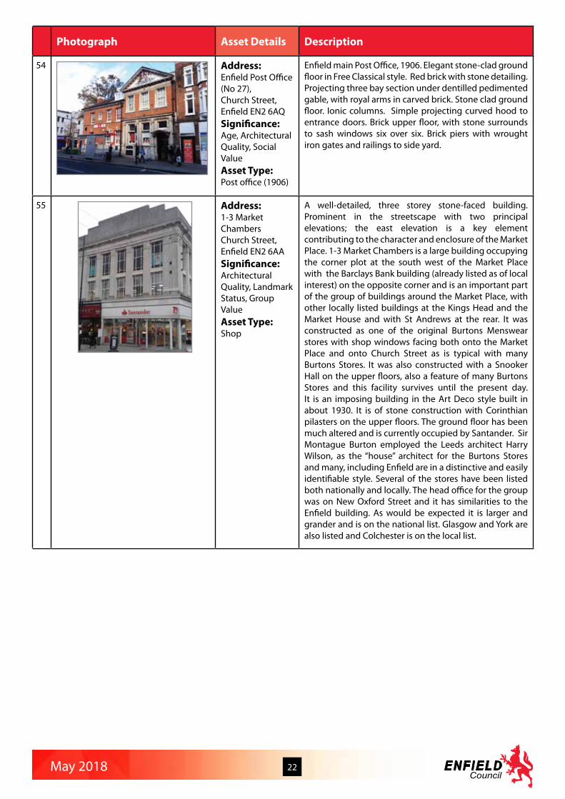
55 Address:1-3 Market Chambers Church Street, Enfield EN2 6AASignificance:Architectural Quality, Landmark Status, Group ValueAsset Type:Shop
A well-detailed, three storey stone-faced building. Prominent in the streetscape with two principal elevations; the east elevation is a key element contributing to the character and enclosure of the Market Place. 1-3 Market Chambers is a large building occupying the corner plot at the south west of the Market Place with the Barclays Bank building (already listed as of local interest) on the opposite corner and is an important part of the group of buildings around the Market Place, with other locally listed buildings at the Kings Head and the Market House and with St Andrews at the rear. It was constructed as one of the original Burtons Menswear stores with shop windows facing both onto the Market Place and onto Church Street as is typical with many Burtons Stores. It was also constructed with a Snooker Hall on the upper floors, also a feature of many Burtons Stores and this facility survives until the present day. It is an imposing building in the Art Deco style built in about 1930. It is of stone construction with Corinthian pilasters on the upper floors. The ground floor has been much altered and is currently occupied by Santander. Sir Montague Burton employed the Leeds architect Harry Wilson, as the “house” architect for the Burtons Stores and many, including Enfield are in a distinctive and easily identifiable style. Several of the stores have been listed both nationally and locally. The head office for the group was on New Oxford Street and it has similarities to the Enfield building. As would be expected it is larger and grander and is on the national list. Glasgow and York are also listed and Colchester is on the local list.

May 2018 23
Photograph Asset Details Description
56 Address:New River House (Nos 88 and 90)Church Street, Enfield EN2 6ARSignificance:Age, Historic Association, Architectural Quality, Landmark StatusAsset Type:Dwellinghouses
No 90 is a three bay, three storey brick house with two storey bay windows, tiled rood behind parapet, projecting porch addition, semi circular fan light over front door. No 88 is an attached two storey, two bay brick extension. Tiled hip roof, sash windows eight over eight and flat gauged arches.Although currently called River House, and occupied by Breeze and Wyles Solicitors, one hundred years ago 90 Church Street was called New River House and was occupied by a 33 year old doctor (Surgeon) Edwyn Manners Ridge and his housekeeper. The house is recorded in the 1911 census as having 10 rooms. This was a time of great change for this western end of Church Street, Enfield Town, because the 1896 Survey shows Chase Side House still standing where Library Green is, but fast coming towards the end of its life, but by the 1914 Survey Chase Side House has been demolished and Cecil Road has been connected from its cul-de-sac by Raleigh Road through to the western end of Church Street. The 1866 Survey shows a property on the same site as New River House and although it has not yet been possible to ascertain if this was the same building, the 1881 Census shows it divided into four lodgings with a coachman, a master builder, a seamstress and an annuitant in residence. So certainly it was at least as large as the 1911 building and seems to have the same footprint.
57 Address:The Kings Head Public HouseChurch Walk, Enfield EN2 6LL Significance:Architectural Quality, Landmark Status, Social Value, AestheticAsset Type:Public house
1899 by Shoebridge and Rising. Domestic Old English style. Three storey, red brick. Tile hung upper storeys, half timberd gables. Tudor style chimneys. Carved bracket to door. Etched glass on ground floor. It replaced the 17th century King’s Head on the same site.

May 2018 24
Photograph Asset Details Description
58 Address:KingswoodClay Hill EN2 9JBSignificance:Architectural QualityAsset Type:Dwellinghouse
Large detached house built in the Tudor style in extensive grounds about 1873 with lodge cottage on Clay Hill frontage. First known occupant a Mr Charles Halle (or Halls) with his wife, three daughters, four sons and six servants. He is described as railway clerk but this must mean something other than it does today. By 1878 there is Morton Latham in residence. He was a JP and Chairman of the local Board of Guardians. He was also the first alderman to serve on the newly created Middlesex County Council. The house was sold in 1893 and then occupied by Reverend Beresford Potter the incumbent of St John’s Church. He made a large number of improvements to the house and grounds before he decided the estate was too much for him. Potter sold the house in 1901. The next owner was Bernard Roth FRCS, orthopaedic surgeon. He was a JP in Enfield. He lived in the house from 1905 – 1916. Next was Raymond Rochford son of John Rochford (Rochford Nursery). He acquired 2 Adam fireplaces from Durants Arbour for the house and made improvement to the grounds. His widow left in 1954 and a Mr Engel moved in. He died in 1993. Then the house was occupied by the Karic family. Sold again in 2003 to the Legister family. Information from a History of Crews Hill by Roy Martin.
59 Address:Cockfosters Water TowerCockfosters Road EN4 0PS Significance:Architectural Quality, Landmark StatusAsset Type:Water tower
1968. Water tower designed with a interlaced hyperbolic lattice by architect Edmund Percey and J.W. Milne, Chief Engineer of Lee Valley Water.
60 Address:West Lodge Park Hotel including AboretumCockfosters Road EN4 0PYSignificance:Age, Historic Association, Designed Landscape, Social ValueAsset Type:Former Dwellinghouse/Hotel and Gardens
West Lodge was one of the three keepers’ lodges on Enfield Chase. The present house was built on the site of the original in 1835. It became a hotel in 1924 and was purchased by Edward Beale in 1945. It continues to be run as a hotel by the Beale family. The lake in front of the hotel was originally a fish pond in use when hunting parties stayed at the lodge. In 1963 Edward Beale established an arboretum on ten acres of parkland. There are now 800 varieties of trees and shrubs. The oak in front of the hotel dates from 1840. West Lodge Park Hotel is a mid to late C19th five bay, two storey building with attic. Stucco elevations. Projecting quoin detail. Oversailing eaves to slate roof. Projecting string course detail between ground and first floor. Sash windows six over six. Flat roof single storey projecting porch. Centre rebuilt later C19th, north and west extensions C20th. Site formerly occupied by C16th lodge of Enfield Chase underkeeper.

May 2018 25
Photograph Asset Details Description
61 Address:1 Cooks Hole Lane, Enfield EN2 0UDSignificance:Rarity, Architectural Quality, Aesthetic MeritAsset Type:Dwellinghouse
Two-storey thatched-roof cottage with hooded dormer windows and two chimney stacks; rendered walls and Thatched roof buildings are very unusual in Enfield. Private house maintained in very good condition.
62 Address:24 Dryden RoadBush Hill Park, Enfield EN1 2PPSignificance:Rarity, Historic Association, Architectural Quality, Landmark Status, Urban DesignAsset Type:Dwellinghouse
Bright red brickwork and bold massing, including prominent white painted gables, give both houses prominence and high quality of detailing; particularly the semi-circular side bays add interest. Identified in the conservation area Character Appraisal as a landmark building, built in the second phase between 1896 and 1914, number 24 Dryden Road is a very large house built in the Arts and Crafts style. Initially, the North London Estates Company was slow to develop the land. However, the building of Bush Hill Park station in 1880 on the existing Great Eastern Railway branch to Enfield Town provided an impetus for development. The first phase took place between 1880 and 1886, and was divided into a prestige development in Village Road and along the north east side of Private Road and more modest, but still substantial, houses on the west side of Wellington Road, the south side of Queen Anne’s Place and the north side of Dryden Road. Most of the earliest houses were designed for the company by R. Tayler Smith.
63 Address:Highway Verges Dryden Road, Queen Annes Gardens, Queen Annes Place & Wellington Road, Bush Hill Park, Enfield EN1Significance:Rarity, Urban Design, Designed Landscape, AestheticAsset Type:Landscape street verges
The length, width, variety of planting, maturity and historic value of these verges make them unique to the Borough. Photographic evidence from Enfield Council’s archives shows the early stages of the verges in the years 1900 to 1920. In these early years the lime trees (the predominant tree type) were heavily pollarded. The beds were surrounded by low hooped fencing which has long disappeared.

May 2018 26
Photograph Asset Details Description
64 Address:Ediswan Building Duck Lees LaneEN3 7UHSignificance:Historic AssociationAsset Type:Office and factory
The former Ediswan factory general office block of 1890, at Ponders End, occupies part of a site associated with Sir Joseph Swan (1828-1914), inventor of the incandescent electric lamp, Sir James Dewar (1842-1923), inventor of the vacuum flask, and Professor Sir John Ambrose Fleming (1849-1945), inventor of the diode radio valve in 1904, which marks the birth of the electronic technological revolution. Britain’s first radio valve and television cathode ray tube factories were opened here, in 1916 and 1936 respectively.
65 Address:St John the EvangelistDyson Road, Upper Edmonton N18 2DSSignificance:Architectural Quality, Landmark Status, Social ValueAsset Type:Place of worship
St John the Evangelist (St Mary with St John’s Church) was designed by Charles Henry Bourne Quennell and built in 1906, along with the church hall and vicarage, by the builder Albert Monk and glazier Paul Woodroffe. It was refurbished in 2013. The church is a part of a significant suite of linked buildings by the same architect and built as a piece. They include the church, cloister, church hall and vicarage. Part of the architectural uniqueness of the church is that grouping of Arts and Crafts buildings around the central cloister.
66 Address:Eastfield Primary School and Caretaker’s HouseEastfield RoadEN3 5UXSignificance:Age, Architectural Value, Social ValueAsset Type:School and dwellinghouse
Built 1908 and opened in January 1909. It was built on land previously used for an agricultural nursery and greenhouses. The main building appears largely unaltered from its original design.
67 Address:4 Essex Road, Enfield EN2 6TZSignificance:Age, Rarity, Architectural Quality, Landmark StatusAsset Type:Dwellinghouse
Two storey yellow brick house, low pitched slate roof. 4 Essex Road makes a positive contribution to the area, set back behind a sweeping paved driveway. Identified on the OS Map of 1881 as having been built by this time, this is a square set building in a mid nineteenth Century style with evenly spaced wide windows and a prominent pillared porch and doorway. Suburban development began shortly after the opening of the first railway station in 1849. The first major development was Enfield New Town (Raleigh Road, Essex Road, Sydney Road and Cecil Road) which was built up from 1852. This was a mixed development with large houses in London Road and Essex Road and small workmen’s cottages in Sydney Road and Raleigh Road.
May 2018 27
Photograph Asset Details Description
68 Address:25 Essex Road, Enfield EN2 6TZSignificance:Age, Historic Association, Architectural Quality, Group Value, Asset Type:Dwellinghouses
One of the very few houses showing on the 1866 OS Map in this road. The land for Essex Road was bought in 1852 by the National Freehold Land Society as part of the Enfield New Town development. Building was started the following year.
69 Address:8 Eversley CrescentN21 1EJSignificance:Rarity, Architectural Quality, Aesthetic MeritAsset Type:Dwellinghouse
8 Eversley Crescent is a substantial two storey detached house in an Arts and Crafts influenced Tudorbethan style dating from the 1920. It is an unusual unaltered survival of the high quality and inventive inter-war speculative development that took place in Eversley Crescent. It is in an elevated position and is characterised by its distinctive fish-scale clay tiled hipped roof with a deep eaves; a rendered and half-timbered first floor projecting squared bay with diamond patterned leaded light timber casement windows with top lights; brickwork to the ground floor; a distinctive oak entrance screen projecting forward of the adjoining ground floor splayed bay, with flattened ogee shaped side lights and solid door; a sweeping roof and a gabled dormer extending down over the projecting garage, with its part glazed garage doors. The door has decorative iron work knocker and letter box and a central leaded “peep hole” window. It is well detailed and retains all its original features and is a pleasing composition.
70 Address:Boundary Wall, 2a - 8 Eversley Mount, Oak Lodge, 50 Eversley Park Road, 33 & 37 Eversley CrescentSignificance:Age, Rarity, Architectural Quality, Urban DesignAsset Type:Boundary wall to Arnos Park Estate
Originally constructed as part of the boundary of Eversley Park, a large Victorian house of Italianate design which stood at the corner of Eversley Park Road and Green Dragon Lane and was demolished in the 1920’s. Along with the Lodge House which still exists at the junction of Wades Hill and Green Dragon Lane, these sections of wall are the only surviving features of Eversley Park. Yellow stock brick laid in Flemish bond, approximately 3.5m high. A number of openings into Eversley Mount with segmental red brick arches and modern metal gates. Along the length of wall to the rear of 50 Eversley Park Road are several bricked up recesses.

May 2018 28
Photograph Asset Details Description
71 Address:35 Eversley CrescentN21 1ELSignificance:
Asset Type:Dwellinghouse
A very handsome, generously scaled, property located in a perfect setting with all of the original features intact. In particular,the fenestration, noting the vary rare and intricate leaded lights in the ground floor bay window. The developer of Eversley Crescent retained this property for his own use. The quality of the interior has been carried through to the interior.
72 Address:The Cot Flash Lane, Enfield EN2 9JHSignificance:Age, Architectural QualityAsset Type:Dwellinghouse
In 1847 James Whatman Bosanquet (the banker and founder of the Protestant Association which was established to counter the Oxford Movement) who lived at nearby Claysmore House between 1847 and 1877, introduced Sunday afternoon services and lectures for working class people in this mid 19th century cottage. The chapel and school remained in use until 1875 and the lancet windows of the former chapel can still be seen. The former schoolhouse provides a large residential property in two sections. The rear of the former school appears to have been added slightly later than the front section, presumably as the local settlement grew and the population rose. Original windows in chapel style, original chimney stacks. Minor window changes to the rear of the school building.
73 Address:60 Fore StreetN18 2SWSignificance:Age, Rarity, Architectural QualityAsset Type:Former Dwellinghouse/Offices
Late C18th or early C19th. Three storey stock brick building. Slate roof behind parapet. Two windows wide, sash six over six. Arched entrance door with fluted columns and decorative motifs around head.

May 2018 29
Photograph Asset Details Description
74 Address:No 134 Fore StreetN18 2XASignificance:Age, Rarity, Architectural QualityAsset Type:Shops/flat
No 134 and its neighbour 136 are shown on OS maps from 1867 with the same footprint ie with the shop extension presumably. By 1882 No.134 was a grocer’s shop and sub Post Office run by Henry Moses Lewis. It remained a shop and sub Post Office in the name of Henry Moses Lewis until at least 1936. By 1941 it was no longer a post office. To the north of No.136 is the entrance to the alley way known as Trafalgar Place (photo attached). Trafalgar Place was a row slum properties cleared in the 1950s/60s and in existence at the time of the 1841 census. Cannot identify the houses on any earlier maps or in any earlier directories but perhaps it would be safe to say that it is earlier than 1841. By 1882 No.134 was a grocer’s shop and sub Post Office run by Henry Moses Lewis. It remained a shop and sub Post Office in the name of Henry Moses Lewis until at least 1936. By 1941 it was no longer a post office. Best surviving example of later C18/early C19 terrace with bungalow shopfronts. Although brickwork has been painted retains sash windows and is relatively unaltered above ground floor.
75 Address:No 169-171 Fore Street N18 2XB Significance:Age, Rarity, Architectural QualityAsset Type:Shop and assembly rooms above
Classical Art deco former Burton store. The name is still visible at high level. Portland stone with ornamental stone pillars. The original metal windows at first & second floor are currently boarded over because of a nightclub inside. The one remaining building of significant quality on this section of the shopping centre, but currently part vacant and in poor condition.
76 Address:No 170-172Fore Street N18 2JBSignificance:Age, Rarity, Architectural QualityAsset Type:Shops and flats above
Late 19th Century shops with residential accommodation above. Probably built as shops, whereas the adjoining properties to the north are probably residential, later adapted for shopping use. Attractive stonework detailing at ground and first floor level. A good surviving example of the growth of the area as a shopping centre in the late 19th century. The properties are currently in poor condition.

May 2018 30
Photograph Asset Details Description
77 Address:No 196 Fore StreetN18 2JD Significance:Age, Rarity, Architectural QualityAsset Type:Shops and flats above
The earliest date confirmed for the building is the 1891 census when William Schlenker, a grocer, was living there. Harvey’s Off Licence was there in 1910 and 1922. The shop is not listed in 1936 or 1941 rate books and it appears to be vacant again in 1982. Typical late C18/early C19 townhouse, rare survival of Fore St’s Georgian expansion in largely intact form. Sash windows still in place.
78 Address:No 198 Fore StreetN18 2JD Significance:Age, Rarity, Architectural QualityAsset Type:Former Bank
No.198 is identified on the 1938 OS map as a “Bank”, but not on the 1936 edition. The 1936 rate book lists No.198 as Sanders Bros. house shop and premises. It was built for Westminster Bank in 1937/8.
79 Address:353 and 353CFore Street N9 0NRSignificance:Age, Rarity, Group ValueAsset Type:Shops and flats above
A large shop of 1903, purpose-built for the Edmonton Co-operative Society, now divided into three, with flats over, in red brick with brown terra cotta dressings, in a free Edwardian artisan mannerist/baroque style – robust and exuberant.
80 Address:Nills (No 273)Fore Street N9 0PDSignificance:RarityAsset Type:Shops
A restrained Art Deco shop with offices above. Built during the inter-war period, formerly the Green Shield Stamps shop with warehousing above, converted into first and second floor offices in 2010. The original crittal windows were replaced as part of the recent refurbishment. Attractive ‘ classical’ detailing between the first and second floors.

May 2018 31
Photograph Asset Details Description
81 Address:The Phoenix Pub (LTs), No 58 Fore Street N18 2SWSignificance:Age, Rarity, Architectural Quality, Social ValueAsset Type:Public House
The Phoenix appears as such in the 1911 census. It was also in the 1891 census but no name is given. It was described as a beerhouse. Close examination of the stonework at the front, between the ground and first floors, appears to show carvings of a phoenix. The footprint had changed between the 1896 and 1914 maps. There is a map of 1912 which shows the same shape of building as the 1914 map but without the usual cross hatching – possibly indicating in incomplete/uninhabited building. The landlord changed in 1911. Now re-named LTs, it is a Spurs pub, with a lot of Tottenham Hotspurs FC memorabilia internally.
82 Address:Canister Lodge29 Forty HillEN2 9EQSignificance:Age, Architectural Quality, Aesthetic MeritAsset Type:Dwellinghouse
Late C18th – early C19th two storey brick house. Slate roof. Four giant two storey arches. Sash windows, four over four. Projecting single storey front entrance. The design resembles a tea canister in design - recognised in its name.
83 Address:Clock House FlatsForty Hill EN2 9EXSignificance:Age, Architectural Quality, Landmark StatusAsset Type:Flats
Complex of buildings dating from early C18th to mid C19th. Large stuccoed house. Three storey centre with vermiculated quoins. Dentil detail to eaves. Projecting single storey flat roofed porched with banded columns. Sash windows one over one. Bow windows to rear. Extended. Converted to flats. The side facing Forty Hill was originally intended to be the rear of the building, and what is now the rear facing the gardens (and not clearly visible from the public road) was the more attractive frontage. There is a Victorian wall-mounted post box on the road frontage. Late C18th or early C19th tall red brick wall.
84 Address:Clock House Nursery Cottage Forty Hill EN2 9EUSignificance:Age, Architectural QualityAsset Type:Dwellinghouse
C19th two storey brick cottage. Tiled roof with decorative fishscale bands. Gabled roof with decorative bargeboards. Hood mould detail above ground floor windows. Highly decorative casement windows. Single storey element with addition. Modern porch addition.

May 2018 32
Photograph Asset Details Description
85 Address:Jesus Church Forty Hill EN2 9EUSignificance:Age, Rarity, Historic Association, Architectural QualityAsset Type:Place of worship
1835 by Thomas Ashwell of Tottenham. Built in imitation of James Savage’s Holy Trinity Church at Tottenham Green. Financed by Christian Paul Meyer of Forty Hall. Church Commissioner’s style, grey brick with paired lancets to aisles and clerestory. Narrow front showing aisles and nave in tight section. Originally with corner finials (east ones removed 1913, west ones simplified). War memorial made up from old turrets. Interior quatrefoil piers and west gallery. Chancel 1926. Pulpit 1872. Screen 1898. Reredos 1933. E. A. Bowles memorial. 4 stained glass windows 1869-81, others 1881-1914, east window 1926.
86 Address:Forty Hill School Forty Hill, next to Maiden’s BridgeEN2 6EYSignificance:Age, Architectural Quality, Landmark Status, Social ValueAsset Type:School
1851 built single storey school with attached two storey teachers house, with some original architectural details including latticed windows. It is a landmark building near Maiden’s Bridge in an otherwise largely rural setting.
87 Address:Palmers Green United Reformed Church and HallFox Lane N13 4ALSignificance:Age, Architectural Quality, Landmark Status, Social ValueAsset Type:Church and church hall
Church hall and church were constructed in 1909 and 1914 (respectively). The buildings were clearly designed as related pieces and are of a high quality florid Gothic design in brick and stone with arts and crafts motifs. The buildings are prominent local landmarks due to their corner location.
88 Address:The Bank (36 to 38)Friern Barnet Road, New SouthgateN11 1NASignificance:Architectural Quality, Landmark StatusAsset Type:Formerly a bank, now a vacant public house
The Bank is a distinctive turn of the century building on the corner of Station Rd and Friern Barnet Road. It’s commanding position gives it landmark status. It was originally a bank, then a pub and is now unoccupied.

May 2018 33
Photograph Asset Details Description
89 Address:Jubilee ParkGalliard Road,Edmonton N9 7RHSignificance:Designed Landscape, Social ValueAsset Type:Public park
Edmonton UDC acquired 37 acres of land west of Hertford Road in order to provide recreational facilities for the growing population as the area became increasingly built up. The site was previously used for brickworks, a major local industry until the 1970s, and many of the surrounding houses were probably built from local bricks. Jubilee Park was planned in commemoration of George V’s Silver Jubilee in 1935 but in the event the park did not open until 1939, after the King’s death. The park has fine a Art Deco style entrance on Galliard Road, and has recreational facilities as well as ornamental planting.
90 Address:4 Generals’ Walk, Enfield EN3 6BXSignificance:Historic Association, Group ValueAsset Type:Dwellinghouses
One of a terrace of four houses that is all that remains of the Officers Quarters for the Royal Small Arms Factory. Originally there were other larger houses which were also Officers Quarters, facing directly onto Ordnance Road which have now been demolished.
91 Address:Genotin TerraceGenotin Terrace, Enfield EN1 2AFSignificance:Age, Urban DesignAsset Type:Dwellinghouses and offices
Built in the early 1890s Genotin Terrace is a little gem and a key view at the eastern approach to Enfield Town Conservation Area. Genotin Terrace is a rare example of urban design, perhaps unique in the Borough, where dwellings with small front gardens are arranged facing each other across a pedestrian way.
92 Address:4 Gentleman’s Row, Enfield EN2 6PUSignificance:Age, Architectural QualityAsset Type:Dwellinghouse
C17th – timber framed cottage with later alterations. River Cottage, one of a group of four. Built on encroachment of land from Enfield Chase. Two /three storey, with rooms in roof. Weather boarded with high pitched tiled roof. Alterations, including porch.
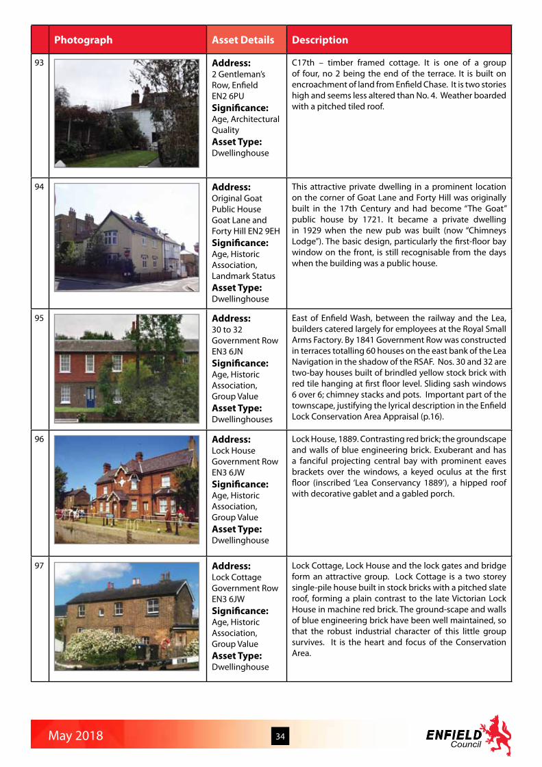
May 2018 34
Photograph Asset Details Description
93 Address:2 Gentleman’s Row, Enfield EN2 6PUSignificance:Age, Architectural QualityAsset Type:Dwellinghouse
C17th – timber framed cottage. It is one of a group of four, no 2 being the end of the terrace. It is built on encroachment of land from Enfield Chase. It is two stories high and seems less altered than No. 4. Weather boarded with a pitched tiled roof.
94 Address:Original Goat Public House Goat Lane and Forty Hill EN2 9EH Significance:Age, Historic Association, Landmark StatusAsset Type:Dwellinghouse
This attractive private dwelling in a prominent location on the corner of Goat Lane and Forty Hill was originally built in the 17th Century and had become “The Goat” public house by 1721. It became a private dwelling in 1929 when the new pub was built (now “Chimneys Lodge”). The basic design, particularly the first-floor bay window on the front, is still recognisable from the days when the building was a public house.
95 Address:30 to 32 Government Row EN3 6JN Significance:Age, Historic Association, Group ValueAsset Type:Dwellinghouses
East of Enfield Wash, between the railway and the Lea, builders catered largely for employees at the Royal Small Arms Factory. By 1841 Government Row was constructed in terraces totalling 60 houses on the east bank of the Lea Navigation in the shadow of the RSAF. Nos. 30 and 32 are two-bay houses built of brindled yellow stock brick with red tile hanging at first floor level. Sliding sash windows 6 over 6; chimney stacks and pots. Important part of the townscape, justifying the lyrical description in the Enfield Lock Conservation Area Appraisal (p.16).
96 Address:Lock HouseGovernment RowEN3 6JWSignificance:Age, Historic Association, Group ValueAsset Type:Dwellinghouse
Lock House, 1889. Contrasting red brick; the groundscape and walls of blue engineering brick. Exuberant and has a fanciful projecting central bay with prominent eaves brackets over the windows, a keyed oculus at the first floor (inscribed ‘Lea Conservancy 1889’), a hipped roof with decorative gablet and a gabled porch.
97 Address:Lock CottageGovernment RowEN3 6JWSignificance:Age, Historic Association, Group ValueAsset Type:Dwellinghouse
Lock Cottage, Lock House and the lock gates and bridge form an attractive group. Lock Cottage is a two storey single-pile house built in stock bricks with a pitched slate roof, forming a plain contrast to the late Victorian Lock House in machine red brick. The ground-scape and walls of blue engineering brick have been well maintained, so that the robust industrial character of this little group survives. It is the heart and focus of the Conservation Area.

May 2018 35
Photograph Asset Details Description
98 Address:Hollywood GardensGreat Cambridge Road/Hedge LaneN13 5DDSignificance:Designed Landscape, Social ValueAsset Type:Public gardens
Adjoining Tatem Park, Hollywood Gardens was a gravel pit before being used as a refuse dump by Tottenham Borough Council. It was bought by Edmonton Council in 1949 and in 1950 landscaped and laid out as a public garden. It was named after Alderman A. J. Hollywood, a long-serving Labour member of Edmonton Council. Hollywood gardens were officially opened in 1956.
99 Address:Tatem ParkGreat Cambridge Road/Hedge LaneN13 5DDSignificance:Designed Landscape, Social ValueAsset Type:Public park
Tatem Park was originally a gravel pit leased to Southgate Council where in 1913 fossilised mammoth bones were discovered. In 1934 the land was given to Edmonton Council by the Harman sisters (who had inherited the Weir Hall estate) for the purpose of creating a recreation ground for children. The sisters requested that the name of their uncle Mr J. G. Tatem who had lived at Weir Hall be perpetuated. Tatem Park was officially opened in 1937. Tatem Park and the adjoining Hollywood Gardens were united in 1983. Playgrounds, cycle and skating tracks have been laid out.
100 Address:Enfield CrematoriumGreat Cambridge Road, Enfield EN1 4DSSignificance:Architectural Quality, Landmark Status, Social ValueAsset Type:Cemetery
Red brick with pantile roof and central campanile; two symmetrical chapel wings. Owned by London Borough of Haringey, Enfield Crematorium was opened by the Mayor of Tottenham in October 1938. It was designed by Sir Guy Dawber (who had been assistant to Sir Ernest George who designed Golders Green crematorium) and A. R. Fox. The broad drive leads to the centre of a brick and pantiled cloister. A brick tower combines the crematorium chimney stack and clock tower and there is a large three tiered fountain. Identical gabled chapels are at each end of the cloister.
101 Address:Edmonton County Grammar SchoolGreat Cambridge Road, Enfield EN1 1HQSignificance:Historic Association, Architectural Quality, Landmark Status, Social ValueAsset Type:School
1931 by WT Curtis. Secondary school with a long dignified front in the Swedish classical tradition; big hipped roof with small cupola. Extended in 1968 after it became comprehensive. The new school could accommodate 600 pupils. William Thomas Curtis was the Chief Architect for Middlesex County Council from 1930-46, and H.W. Burchett was the Assistant Architect for Educational buildings. Between them they designed and built a swathe of modernist public buildings throughout Middlesex, from Twickenham in the west to Enfield in the east. The majority of the buildings they created were educational, but also libraries, health centres and hospitals. Most are still intact and operating in the capacity they were built for. A number have been granted listed status.

May 2018 36
Photograph Asset Details Description
102 Address:Shopfront, No 161Green LanesN13 4SPSignificance:Historic Association, Architectural Quality, Social ValueAsset Type:Shopfront
Edwardian shopfront c.1911 of glass, timber and tiles set within a 3-storey red brick building located at the south-west corner of the junction of Green Lanes and the north circular road ( formerly Bowes Road). Original shopfront partially over clad with timber and modern tiles, but evidence that much original material survives underneath.
103 Address:790 Green LanesN21 3RE Significance:Architectural Quality, Landmark Status, Urban DesignAsset Type:Shops with flats above
Shop with flats over, built 1911. In an eclectic style, with busy roofline and rather strange garden-like turret at the corner. The shopfront, if not original, is in keeping with the architecture. Notable for its landmark quality at the north end of Winchmore Hill Broadway, where it complements Edmonson’s parade on the other side of the road.
104 Address:The Cedars (now Stefan House) (No 698) Green Lanes N21 3RFSignificance:Age, Architectural Quality, Landmark StatusAsset Type:Dwellinghouse (now flats)
Mansion in classical style; porch with columns and entablature and classical window details. Regency-style iron-work veranda on south wall. Originally three bays – left and right bays added. A building which seems to correspond with the present one appears on the 1867 OS map. The house was converted and extended c 2006 to make flats and a new block of flats has been built next to it. All except front façade demolished in 2006. Rare survival of a large house (or at least its façade!) in a subsequently suburbanised area. Tall red brick garden wall possibly of C18th. Tall red brick wall to road boundary possibly of C18th, rebuilt c.1990’s to modern style
105 Address:Winchmore Hill Broadway (Nos 727-763) Green Lanes N21 3RXSignificance:Architectural Quality, Landmark Status, Urban DesignAsset Type:Shopping parade with flats above
This parade of shops forms Winchmore Hill Broadway. It was designed and built in 1904 by James Edmonson, as an adjunct to his residential developments in the area. Though perhaps not as successful architecturally as Edmonson’s other shopping parades (Crouch End, Winchmore Hill and Golders Green) it manages to create a kind of urban and sophisticated ambience in the midst of suburbia, and remains a focus for the area (though it never eclipsed Winchmore Hill village). Architecturally the buildings make good use of the curve of Compton Road; through the use of alternating architectural motifs and by balancing the horizontal and vertical Edmonson managed to combine a sense of a series of separate premises combining to form a unity along the parade. Edmonson (1857-1931) started out as a developer in Highbury. His other work includes the shopping centres in Muswell Hill, Golders Green and Crouch End.

May 2018 37
Photograph Asset Details Description
106 Address:Highfield Pumping Station Green Lanes and Carpenter Gardens, Winchmore HillN21 3HGSignificance:Rarity, Historic Association, Landmark StatusAsset Type:Water pumping station
One of a number of pumping stations installed to increase the flow of water in the New River by pumping water from wells sunk near to its course. It dates from 1885. Symmetrical design with two-storeyed engine house and single-storey blocks to the rear. Although there are a number of similar pumping stations along the New River, the building is nonetheless unusual in its immediate area, and forms part of the overall technical heritage of the New River. It is also an important landmark as part of the local townscape and for those following the course of the River. The pumping station apparently ceased to be used for pumping in 1962. However it appears still to be used by Thames Water and is in reasonable condition. The station appears in HE’s Pastscape database (monument number 1468118). Sources: Pastscape entry; Michael Essex-Lopresti, Exploring the New River (Second edition, 1988).
107 Address:Road sign fingerpostGreen Lanes at junction with Aldermans Hill N13 5TUSignificance:Age, Rarity, Landmark Status, Aesthetic MeritAsset Type:Cast iron directional fingerpost sign
One of five surviving examples in Enfield of the historic cast iron finger post signs directing traffic to long standing settlements which remain important destinations in the modern Borough.
108 Address:Road sign fingerpostGreen Lanes at junction with Station Road N21 3RBSignificance:Age, Rarity, Landmark StatusAsset Type:Cast iron directional fingerpost sign
One of five surviving examples in Enfield of the historic cast iron finger post signs directing traffic to long standing settlements which remain important destinations in the modern Borough.
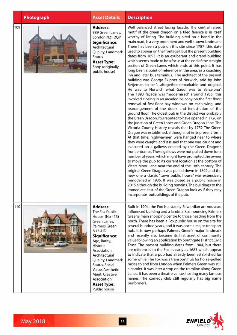
May 2018 38
Photograph Asset Details Description
109 Address:889 Green Lanes, London N21 2QPSignificance:Architectural Quality, Landmark StatusAsset Type:Shop (originally public house)
Well balanced street facing façade. The central raised motif of the green dragon on a tiled faience is in itself worthy of listing. The building, sited on a bend in the main road, is a very prominent and well known landmark. There has been a pub on this site since 1787 (this date used to appear on the frontage), but the present building dates from 1893. It is an exuberant and grand building which seems made to be a focus at the end of the straight section of Green Lanes which ends at this point. It has long been a point of reference in the area, as a coaching inn and later bus terminus. The architect of the present building was George Skipper of Norwich, said by John Betjeman to be “.. altogether remarkable and original. He was to Norwich what Gaudi was to Barcelona”. The 1893 façade was “modernised” around 1935: this involved closing in an arcaded balcony on the first floor; removal of first-floor bay windows on each wing; and rearrangement of the doors and fenestration of the ground floor. The oldest pub in the district was probably the Green Dragon. It is reputed to have opened in 1726 on the junction of Green Lanes and Green Dragon Lane. The Victoria County History reveals that by 1752 The Green Dragon was established, although not in its present form. At that time, highwaymen were hanged near to where they were caught, and it is said that one was caught and executed on a gallows erected by the Green Dragon’s front entrance. These gallows were not pulled down for a number of years, which might have prompted the owner to move the pub to its current location at the bottom of Vicars Moor Lane near the end of the 18th century. The original Green Dragon was pulled down in 1892 and the new one a classic “town public house” was extensively remodelled in 1935. It was closed as a public house in 2015 although the building remains. The buildings to the immediate east of the Green Dragon look as if they may incorporate outbuildings of the pub.
110 Address:The Fox Public House (No 413)Green Lanes, Palmers GreenN13 4JDSignificance:Age, Rarity, Historic Association, Architectural Quality, Landmark Status, Social Value, Aesthetic Merit, Creative AssociationAsset Type:Public house
Built in 1904, the Fox is a stately Edwardian art nouveau influenced building and a landmark announcing Palmers Green’s main shopping centre to those heading from the north. There has been a Fox public house on the site for several hundred years, and it was once a major transport hub. It is now perhaps Palmers Green’s major landmark and recently also became its first asset of community value following an application by Southgate District Civic Trust. The present building dates from 1904, but there are references to the Fox as early as 1683 which appear to indicate that a pub had already been established for some while. The Fox was a transport hub for horse-pulled buses to and from London when Palmers Green was still a hamlet. It was later a stop on the tramline along Green Lanes. It has been a theatre venue, hosting many famous names. The comedy club still regularly has big name performers.
May 2018 39
Photograph Asset Details Description
109 Address:889 Green Lanes, London N21 2QPSignificance:Architectural Quality, Landmark StatusAsset Type:Shop (originally public house)
Well balanced street facing façade. The central raised motif of the green dragon on a tiled faience is in itself worthy of listing. The building, sited on a bend in the main road, is a very prominent and well known landmark. There has been a pub on this site since 1787 (this date used to appear on the frontage), but the present building dates from 1893. It is an exuberant and grand building which seems made to be a focus at the end of the straight section of Green Lanes which ends at this point. It has long been a point of reference in the area, as a coaching inn and later bus terminus. The architect of the present building was George Skipper of Norwich, said by John Betjeman to be “.. altogether remarkable and original. He was to Norwich what Gaudi was to Barcelona”. The 1893 façade was “modernised” around 1935: this involved closing in an arcaded balcony on the first floor; removal of first-floor bay windows on each wing; and rearrangement of the doors and fenestration of the ground floor. The oldest pub in the district was probably the Green Dragon. It is reputed to have opened in 1726 on the junction of Green Lanes and Green Dragon Lane. The Victoria County History reveals that by 1752 The Green Dragon was established, although not in its present form. At that time, highwaymen were hanged near to where they were caught, and it is said that one was caught and executed on a gallows erected by the Green Dragon’s front entrance. These gallows were not pulled down for a number of years, which might have prompted the owner to move the pub to its current location at the bottom of Vicars Moor Lane near the end of the 18th century. The original Green Dragon was pulled down in 1892 and the new one a classic “town public house” was extensively remodelled in 1935. It was closed as a public house in 2015 although the building remains. The buildings to the immediate east of the Green Dragon look as if they may incorporate outbuildings of the pub.
110 Address:The Fox Public House (No 413)Green Lanes, Palmers GreenN13 4JDSignificance:Age, Rarity, Historic Association, Architectural Quality, Landmark Status, Social Value, Aesthetic Merit, Creative AssociationAsset Type:Public house
Built in 1904, the Fox is a stately Edwardian art nouveau influenced building and a landmark announcing Palmers Green’s main shopping centre to those heading from the north. There has been a Fox public house on the site for several hundred years, and it was once a major transport hub. It is now perhaps Palmers Green’s major landmark and recently also became its first asset of community value following an application by Southgate District Civic Trust. The present building dates from 1904, but there are references to the Fox as early as 1683 which appear to indicate that a pub had already been established for some while. The Fox was a transport hub for horse-pulled buses to and from London when Palmers Green was still a hamlet. It was later a stop on the tramline along Green Lanes. It has been a theatre venue, hosting many famous names. The comedy club still regularly has big name performers.
Photograph Asset Details Description
111 Address:The Intimate Theatre (No 521)Green Lanes, Palmers GreenN13 4DHSignificance:Rarity, Historic Association, Landmark Status, Social Value, Creative AssociationAsset Type:St Monica’s Church Hall (now theatre)
The Intimate Theatre is the home of John Clements Theatre company, and the site of the first play ever to have been broadcast live on television. By the end of the 60s it had become the last repertory theatre surviving in London. The theatre still plays host to a range of dramatic and operatic societies, and local events. Many famous people appeared on stage here, including Richard Attenborough (who made his stage debut), Irene Handl, Anna Wing, Nicholas Parsons, Roger Moore, Arthur Lowe, Bill Owen, John Inman, Dad’s Army writer Jimmy Perry and his wife Gilda, Tony Blackburn, Stephen Berkoff, Davy Graham, David Bowie, The Wurzels, Joe Brown, George Melly, Tommy Trinder, Hinge and Bracket, and, in panto Bill Pertwee, Ruth Madoc, and John Noakes. Stevie Smith attended regularly. John Clements was knighted for his contribution to film and stage - Bristol University holds an archive in his memory. One of the last local theatres left in London. Two storey frontage red brick with stone quoins and window surrounds.
112 Address:Syke’s Buildings (Nos 315-397)Green Lanes, Palmers GreenN13 4JGSignificance:Rarity, Historic Association, Architectural Quality, Landmark Status, Group Value, Urban Design, Aesthetic Merit, RarityAsset Type:Shopping parade with flats above
The shopping parade 315 - 397 Green Lanes (1907-13) and is designed in an exuberant ‘New Elizabethan’ style, and is distinctive and possibly unique. It is a key feature of Palmers Green’s street scape, although somewhat neglected. Designed by Arthur Sykes, the parade and the Grade II listed bank building at 288 are both praised by Pevsner. It is a harmonious piece, of a style now unusual in our town centres. It has group value with Nos 286-288 nearby. The parade on Green Lanes extends from the Triangle to Devonshire Road and was originally known as ‘The Market’. It was built in seven stages, between 1909 and 1913, and featuring ellipses, balconies and tall steep new Tudor style gables on four storey buildings. Pevsner recognised the influence of Charles Voysey, the eminent Arts and crafts architect. Of particular interest is the shopfront at the former Grouts store at 397. Decorative Edwardian timber shop frontage. Apart from the decorate timber framing the entrance to the shopfront takes the format of the traditional central recessed lobby with decorative terrazzo floor surface. Grouts was established in 1913 and it is possible that the present shopfront was contemporary with the original construction of this parade. Now overclad but evidence that much original material surviving underneath.
113 Address:Baptist ChurchGreen Lanes, Palmers GreenN21 3PASignificance:Rarity, Architectural Quality, Landmark Status, Social Value, Aesthetic MeritAsset Type:Place of worship
1905, built and designed to a high quality in the arts and crafts style. The most prominent feature is the gable end of the church, which faces onto Green Lanes and presents a part timbered gable end incorporating an arched window with timber swags to the upper part.

May 2018 40
Photograph Asset Details Description
114 Address:305 - 311 (Evans and Davies) Green Lanes, Palmers Green N13 4YBSignificance:Architectural Quality, Landmark StatusAsset Type:Department Store now shops and offices
Former department store dating from 1911 on prominent location facing onto ‘The Triangle’ in Palmers Green. The store closed in 1980 and was converted in 1987 into two ground floor shop units with offices above. This is a strong local landmark building with a high quality symmetrical facade constructed in brick with stone detailing. The design has classical references and has a striking central arch with pediment feature over and strong bracketed parapet.
115 Address:Grovelands Park CaféGrovelands ParkN14 6RASignificance:Designed Landscape, Social ValueAsset Type:Park pavilion
Grovelands Park cafe is a single storey, barn like structure with a very deep, steeply sloping tiled roof. In the centre of the front elevation there is a large gable with inset herringbone patterned brick panels over a large multi-pane window. The walls are largely rough cast stucco. The whole is built on a raised platform to provide a level base as the ground slopes across the grass towards the lake. The platform serves as a seating area in front of the cafe with a view of the lake and Grovelands House beyond,
116 Address:Antila Court, (former Hadley Road Pumping Station)57 Hadley RoadEN2 8JZ Significance:Age, Rarity, Historic Association, Architectural Quality, Landmark StatusAsset Type:Water pumping station
1902-3. Two storey building in red, brown and blue brick with stone detailing. Entrance in projecting arched head surrounding flanked by banded brick work columns. Fan light over doors. Arched windows with decoration around in red brick. Side entrance has steps and set back door with fan light. Associated buildings of simpler design in matching materials. Originally a coal-fired station for drawing well water. Gable ended roof. Projecting string course between ground and first floor. Arches to windows with keystone. Recessed windows with glazing bars. In 2015 being divided into flats, but original internal decoration remaining. New gates at entrance, parking below building.
117 Address:Wolverton (Cedar Park Nursery, No 50) Hadley Road, Enfield EN2 8JYSignificance:Age, Architectural QualityAsset Type:Dwellinghouse
Early C20th country house. Two/three storey with rooms in roof. Brick. Tiled hipped roof. Three Chimney stacks. Central Dutch gable to rear. Dentilled eaves. Contrasting quoin detail. Part vertical tiling. Central verandah on columns, with balcony over at rear.

May 2018 41
Photograph Asset Details Description
118 Address:Building 8Harston DriveEN3 6GHSignificance:Age, Historic Association, Architectural Quality, Group ValueAsset Type:Part of Royal Small Arms Factory
Originally a single storey building of 3 bays with central doorway to the ends and 18 bays to the sides, located at the main entrance to the Royal Small Arms Factory site. Each window is headed by a semi-circular arch formed from polychromatic red and buff brick voussoirs, with a simple dentil cornice and frieze with red brick headers in a diaper pattern set in buff brickwork above, all framed by red brick piers. Hipped slate roof with continuous ridge roof light and blue brick plinth.
119 Address:Fulton CourtHarston DriveEN3 6GHSignificance:Age, Historic Association, Architectural Quality, Group ValueAsset Type:Part of Royal Small Arms Factory
Two storey building with 12 bays to main elevation and central pediment over main entrance. Part of the Royal Small Arms Factory. Ground floor windows are for the most part flat-headed with cambered arched windows at first floor level. Buff brick with corner piers, string courses and eaves cornice all in red brick. Hipped slate roof. Converted to residential use.
120 Address:Pattern Room (Benson Court)Harston DriveEN3 6GRSignificance:Age, Historic Association, Architectural Quality, Group ValueAsset Type:Part of Royal Small Arms Factory
Two storey building of 3 bays with central doorway to the ends and 11 bays to the sides, located between Building 8 and Fulton Court. Buff brick with red brick details and a blue brick plinth. Ground floor windows have semi-circular arched heads with red brick voussoirs and a string course at the springing point; the main entrance doors at each end of the building have cambered arch heads. First floor windows have cambered arch heads and a simple dentil cornice at eaves level all in red brick. Each bay defined by red brick piers. Hipped slate roof.

May 2018 42
Photograph Asset Details Description
121 Address:Latymer School Haselbury Road, London N9 9TNSignificance:Age, Historic Association, Architectural Quality, Landmark Status, Social Value, Aesthetic MeritAsset Type:School
Latymer was established in 1624 on Church Street Edmonton by a bequest of Edward Latymer, a London City merchant in Hammersmith. Although most of his wealth passed to the people of Hammersmith and the Parish of St Dunstan’s (now Latymer Upper School), he named certain properties and estates to fund the education and livelihoods of “eight poore boies of Edmonton” with a doublet, a pair of breeches, a shirt, a pair of woollen stockings and shoes distributed biannually on Ascension Day and All Saints’ Day. Pupils were educated in “Gods true religion” and reading English to the age of thirteen at existing petty schools. In 1662 John Wild of Edmonton made a bequest, including £4 per annum for the maintenance of the school master and a similar sum to maintain a poor scholar at Cambridge. A few bequests were made between 1679 and 1810 in 1811 Ann Wyatt, an eccentric widow form Hackney, left £500 5% Navy Annuities to build a new school, and £100 in the same securities for its maintenance. The school-room was built in 1811 in accordance to her will. Much of the north end of the school (principally the Small Hall and surrounding rooms) was built in 1910 after the Old Latymer Schoolhouse in Church Street was abandoned. The buildings on the present site were provided by Middlesex County Council at a cost of £6,782 and accommodated 150 pupils. Twelve classrooms building in 1924 in the North Block allowed pupil capacity to triple. The Great Hall, science laboratories and South Block were opened in a ceremony in 1928 by the Duke and Duchess of York (later to become King George V1 and Queen Elizabeth the Queen Mother. The oldest part of the building has a fine front entrance with plaster motifs around the top of the double wooden doors. Some of the motifs have the Tudor rose which match the same design on the iron gates. There is also an ornate light towards the top of the double doors, with intricate glass detail.
122 Address:Hazelwood School Hazelwood Lane, Palmers GreenN13 5HESignificance:Age, Landmark Status, Group Value, Social Value, Aesthetic MeritAsset Type:School
School buildings in the arts and crafts style dating from 1908. The buildings were designed by H. G. Crothall, architect for the Middlesex Education Committee, and were erected by local builders, Matlock Brothers, of Wood Green. The design of the buildings reflects the development of the surrounding Hazelwood Park Estate, which was laid out between 1905-10. The buildings are still used as a school and are much loved local landmarks. The buildings are in fair condition. Frontage building to Hazelwood Lane recently repainted and largely retains original architectural features and fenestration. Central building on site is largely unaltered, but in need of external redecoration.

May 2018 43
Photograph Asset Details Description
123 Address:Dharma Opportunities Centre (Nos 442-446) Hertford RoadEN3 5QHSignificance:Age, Historic Association, Social ValueAsset Type:Congregational Church
A freestanding brick building with a pitched roof erected in 1873, the former Enfield Highway Congregational Church. Original stonework on the east elevation particularly at the upper level. The front elevation has been rendered and the building has been considerably altered. It closed in 1919 and became the Co-op Hall.
124 Address:No 508 Hertford Road EN3 5SSSignificance:Age, Group ValueAsset Type:Dwellinghouse
508 is a mid-Victorian yellow brick three storey building housing Hills Cafe. The windows have been replaced, but sympathetically with the style of the building. There is a ghost sign on the front elevation reading ‘Eat Hill’s Gold Seal Bread’. If this is original it may indicate that the building previously housed a bakery.
125 Address:The Cock Public House124 Hertford Road at junction with Houndsfield Road, Enfield N9 7ESSignificance:Age, Architectural Quality, Landmark Status, Urban Design, Social ValueAsset Type:Public House
A local public house, now closed down and being converted. This is a substantial building which is well known locally and probably dates from the time when the road was one of the main routes north out of London. There is a wrought iron balcony and weather vane both of which appear original. Interesting design to main upstairs window facing the main road and all other windows are of interesting design. Mouldings below roof line.
126 Address:Hertford CemeteryHertford Road, Enfield Highway, EN3 5JESignificance:Historical Assocation, Designed Landscape, Social ValueAsset Type:Cemetery
Hertford Road Cemetery opened in 1880 on land acquired by the Enfield Burial Board and was developed as a separate entity from the adjacent churchyard of St James. The C19th Cemetery Lodge is a two-storey brick building, now largely destroyed by fire, having been sold by auction in the late 1990s. After the Burial Board was wound up in the 1920s, the cemetery was later owned by LB Enfield, and the Lodge used by the Parks Superintendent and then as a Parks store.

May 2018 44
Photograph Asset Details Description
127 Address:Edmonton Baptist ChurchHertford Road at junction with Monmouth Road N9 0LSSignificance:Architectural Quality, Landmark Status, Social ValueAsset Type:Place of worship
1974. Octagonal with spike. A friendly contrast to the neighbouring shopping complex. Yellow stock. Eaves fascia, metal roof. Full height coloured glass screens in metal frame. Reminiscent of mid C20th Festival of Britain style.
128 Address:258 Hertford Road, Enfield EN3 5BNSignificance:Age, Historic Association, Architectural Quality, Social ValueAsset Type:Offices (formerly public library)
Officially opened May 1910 although date on building is 1909. Enlarged 1938. Stock brickwork with red brick facing to front and stone dressing segmental window. String course decoration to front. Main door has broken pediment with date in gap. Designed by borough architect Richard Collins and built by Henry Knight builders of Tottenham. Cost £4,000 donated by Andrew Carnegie. The Borough’s travelling Library started here 1947. Possibly the first library built by Enfield Urban District Council. Central Library not built until 1912. Much of the original interior (local archives have photos) have been replaced, though the staircase, timber skirting, ceiling cornicing and first floor parquet flooring remains. The rear northern two storey annexe extension was built simultaneously or shortly after the main library building and is of less interest than the frontage buildings. The south-eastern rear extension is a modern addition.

May 2018 45
Photograph Asset Details Description
129 Address:Durants ParkHertford Road, Enfield EN3 7EDSignificance:Historic Association, Designed Landscape, Social ValueAsset Type:Public park
Durants Park is named after Durants, one of the eight sub-manors of the Enfield Estate, which date from the C13th when William the Conqueror granted Enfield to Geoffrey de Mandeville. It was allegedly named after the family of an Adam Durant recorded here from 1244. In the early C15th the Durants estate was owned by the Wroth family who held land in Middlesex for a number of centuries, Sir Thomas Wroth and his son Sir Robert Wroth both holding important positions in Elizabethan times. James I was reputedly a frequent visitor. It was later owned by Sir Thomas Stringer, whose wife Lady Stringer lived here until 1727 and is buried at St Andrew’s Church (q.v.). Their son, William, married a daughter of the infamous Judge Jeffreys who was known to have visited Durants and fortifications could be seen on an outbuilding, reputedly erected for his protection. In 1910 this and the remains of the moated manor house, Durants Arbour, were demolished. The site of the moated manor house was south of the public park to the east of Ponders End High Street but it had been destroyed by fire in the late C18th although the Tudor gateway remained until 1910; it remained marked on OS maps into the 1920s. The moat has been filled in and built over. Includes a Georgian-style single storey building which appears on mid 19th century Ordnance Survey maps as “Lodge”. Durants Arbour was a moated manor house of medieval origin. Home of the politically influential Wroth family throughout the Tudor period. Sir Thomas Wroth was a gentleman of the Privy Chamber of Edward VI. He backed Lady Jane Grey and was forced to take refuge abroad when Mary Tudor came to the throne. Both Sir Thomas and his son Sir Robert Wroth were prominent MPs during the reign of Elizabeth I.Durants Manor later became the home of the Stringer family, one of whome married the daughter of the notorious Judge Jeffreys.. The last parts of the manor house were demolished early 20th century and a housing estate now covers the area. Parts of Durants Arbour may have been incorperated into Kingswood Clay Hill. The lodge is now faced by green corrugated sheets but parts of the original structure are still visible. Had been used as office by the previous tenant of the Timber Yard.
130 Address:King William IV Public HouseHertford Road, Enfield (nr junction with Bury Street)N9 7HHSignificance:Age, Architectural Quality, Landmark StatusAsset Type:Public house
Tudor-style public house with two projecting timber-framed bays with original transomed and leaded light windows to first and second floors. Original pub sign on front and side wall. Original hanging metal lights to front of building.

May 2018 46
Photograph Asset Details Description
131 Address:30 to 34, 40-44 (even), High Street N14 6EBSignificance:Rarity, Architectural Quality, Group ValueAsset Type:Shops
A crescent shopping parade at the entrance to the Meadway estate. Fine faience detailing on the stonework between the shop units particularly no 30 -34. A crescent of brick and terracotta shops with faience details, known as the Quadrant, were built in the late 1920s at the entrance to the Meadway Estate. They are a good example of a type that is now rare in the area.
132 Address:Ponders End Technical Institute (Nos 219-221)High Street, Ponders End EN3 4DXSignificance:Architectural Quality, Social ValueAsset Type:Ponders Technical Institute
1911. Ediswan Institute established in 1901, taken over by Middlesex CC in 1905, then rebuilt as Ponders End Technical Institute in 1911. Joseph Swan was the co-inventor with Thomas Edison of the electric light bulb and found of Edison Swan United electric Light factory in Ponders End.
133 Address:Ponders End Recreation GroundHigh Street, Ponders End EN3 5BESignificance:
Asset Type:Public park
The land known as O’Ryan’s Field was taken over by Enfield Council for wartime allotments in 1916. At first rented out to the Ponders End & District Smallholders Club, in 1923 it was ploughed and levelled and laid out as a public park. It was opened to the public as Ponders End Pleasure Park in 1924. The land was said to have been part of an estate belonging to John O’Ryan and the name O’Ryan ‘s Field or Ryans Park persists locally even to this day. The band stand was erected in 1936.
134 Address:Enfield Telephone Exchange, No 40High Street, Ponders End EN3 4BSSignificance:Age, Rarity, Architectural Quality, Landmark Status, Social ValueAsset Type:Telephone exchange
In Ponders End, housing development resumed after World War I. The gaps separating Ponders End from Edmonton and Enfield Highway were finally closed. Much former market garden land was built upon. By 1939 the area was virtually fully developed. All of this development, particularly industrial expansion, required a proper telephone exchange which was built at 40 High Street in 1935. It is a unique type of commercial building built for the telephone company in the 20th Century. Because of its size and unique location on the High Street it forms an attractive landmark building, and is still in very active use today (2016). The surviving detailing is a good example of Flemish bond brickwork and quality joinery, with large arched multiple-light and inset sash windows, cast iron hoppers and downpipes.

May 2018 47
Photograph Asset Details Description
135 Address:The Goat Public HouseHigh Street and QueensburyEN3 4HB Significance:Age, Architectural Quality, Landmark Status, Social ValueAsset Type:Public house
The earliest date the Goat was noted was in the Court Baron Records of Durant in September 1778. The current building dates back to about 1930. The large garden at the rear started to disappear from 1947 to build the current industrial units.
136 Address:5 and 7 High Street, Southgate N14 6LASignificance:AgeAsset Type:Dwellinghouses
C18th double span pair of cottages with roughcast walls and tiled roof. Two storey. Sash windows, ground floor eight over eight, first floor six over six. Windows to 7 have decorative gothic arch headed glazing bars to upper sash.
137 Address:No 27 High Street, Southgate N14 6LDSignificance:Age, Rarity, Architectural QualityAsset Type:Shops and flats above
An original early 19th century brick cottage with pitched roof. The modern shop front, extension to the south elevation and upvc double glazed windows mean that little of the original structure is visible.
138 Address:Lawn Villa and Lawn Cottage (Nos 13 and 15) Holly WalkEN2 6QDSignificance:AgeAsset Type:Dwellinghouses
Early – mid C19th pair of stock brick cottages with slated roofs and fine sash windows.

May 2018 48
Photograph Asset Details Description
139 Address:Enfield County SchoolHolly Walk, Enfield EN2 6QGSignificance:Age, Architectural Quality, Creative AssociationAsset Type:Girls Grammar School
Built as a Girls’ Grammar School in 1909 by H G Crothall of the MCC. An attractive formal composition in brick and stone, on an H-plan, similar to his other schools (cf Edmonton and Tottenham) but personalized here by perky Art Nouveau copper domes on the corner turrets” Pevsner. The ornate Art Nouveau influenced stonework and railings are also worth a mention. The building appears to be in good and original condition. Other schools by this architect have been listed both locally and nationally. Frances Perry local horticulturist, author and broadcaster went to this school.
140 Address:Royal British Legion, Old Fire Station (No 36)Holtwhites Hill, Enfield EN2 0RXSignificance:Age, Historic Association, Landmark StatusAsset Type:Fire station
The building was originally a fire station built in 1936. It has an accompanying hose-drying tower behind. It is an impressive building with some art deco embellishment - including at the top of the tower. A multiple placque to Enfield’s war dead is in the centre-front of the building at pavement level. It was take over by the Royal British Legion for use as their club house and remained in use until 2012. The building now seems to be occupied with small-scale businesses. The building fabric and decoration remains in good condition though the tower is heavily adorned with mobile phone antennas. The building and tower were featured as a location in the 1966 half-hour ‘sound effect’ comedy film ‘Simon Simon’ staring Graham Stark and John Junkin and featuring cameo appearances by Peter Sellers, Michael Caine, Bob Monkhouse, Tony Blackburn and Morcambe and Wise.
141 Address:Salisbury ArmsHoppers RoadN21 3NPSignificance:Architectural Quality, Landmark Status, Urban Design, Social ValueAsset Type:Public house
Built in 1935 by Wenlock’s Brewery on land previously occupied by Belmont House, opened February 1936. The Salisbury Arms is a prominently sited and well-designed building in red brick with stone detailing, with crow-stepped gables, hipped dormers, oriel windows, and stone-mullioned and leaded casement windows.
142 Address:84 to 86 Hoppers Road N21 3LHSignificance:Age, Architectural Quality, Group ValueAsset Type:Dwellinghouses
84 and 86 are a pair of double-fronted cottages under a hipped roof with doors recessed with arches above. Sash windows; visible segmented flat arches, though painted over. 80-82 are smaller and have plastic replacement windows. Local histories say that 80-82 are c1770. 84 and 86 may be of similar date.
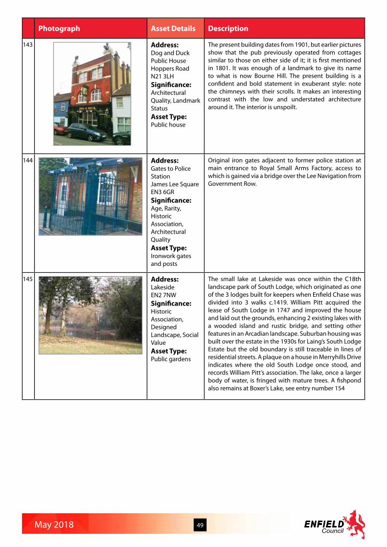
May 2018 49
Photograph Asset Details Description
143 Address:Dog and Duck Public HouseHoppers Road N21 3LHSignificance:Architectural Quality, Landmark StatusAsset Type:Public house
The present building dates from 1901, but earlier pictures show that the pub previously operated from cottages similar to those on either side of it; it is first mentioned in 1801. It was enough of a landmark to give its name to what is now Bourne Hill. The present building is a confident and bold statement in exuberant style: note the chimneys with their scrolls. It makes an interesting contrast with the low and understated architecture around it. The interior is unspoilt.
144 Address:Gates to Police StationJames Lee Square EN3 6GRSignificance:Age, Rarity, Historic Association, Architectural QualityAsset Type:Ironwork gates and posts
Original iron gates adjacent to former police station at main entrance to Royal Small Arms Factory, access to which is gained via a bridge over the Lee Navigation from Government Row.
145 Address:LakesideEN2 7NWSignificance:Historic Association, Designed Landscape, Social ValueAsset Type:Public gardens
The small lake at Lakeside was once within the C18th landscape park of South Lodge, which originated as one of the 3 lodges built for keepers when Enfield Chase was divided into 3 walks c.1419. William Pitt acquired the lease of South Lodge in 1747 and improved the house and laid out the grounds, enhancing 2 existing lakes with a wooded island and rustic bridge, and setting other features in an Arcadian landscape. Suburban housing was built over the estate in the 1930s for Laing’s South Lodge Estate but the old boundary is still traceable in lines of residential streets. A plaque on a house in Merryhills Drive indicates where the old South Lodge once stood, and records William Pitt’s association. The lake, once a larger body of water, is fringed with mature trees. A fishpond also remains at Boxer’s Lake, see entry number 154

May 2018 50
Photograph Asset Details Description
146 Address:Lancaster Road United Reformed ChurchLancaster Road, Enfield EN2 0BSSignificance:Architectural Quality, Landmark StatusAsset Type:Church
The United Reformed Church in Lancaster Road provides a distinctive local landmark on the corner of Browning Road. In 1884 a piece of ground was bought at the corner of Browning Road and Lancaster Road by the congregation of Christ Church (Chase Side, Enfield) on which a brick building was erected and named “Christ Church Hall Mission”. The foundation stone laid in 1884 by W Holborn Eq JP. It was opened and dedicated for public worship in 1885, and now forms the main body of the present church. In 1937 the original brick mission hall was altered and enlarged at a cost of £2,800. The present church was reopened on 21st May 1938 as Lancaster Road Congregational Church. In 1972 the Congregational and Presbyterian churches united to create the United Reformed Church. Although the building has a simple, unpretentious style, there are some attractive details on the south end facing Lancaster Road, and the church with its small spire stands out among the surrounding undistinguished shops and houses giving a good landmark at this busy road junction.
147 Address:World War 2 PillboxLavender Hill, Enfield EN2 8RPSignificance:Age, RarityAsset Type:Pillbox
Hexagonal brick walled, concrete roofed, World War II pillbox c.1939 with small gun apertures on each face. Originally constructed with tank barriers next to the road bridge at the north end of Gordon Hill station, with the purpose of preventing enemy tanks from using the railway lines to advance further into town. Fair condition but being overgrown with vegetation. Recently revealed to public view through replacement of wooden fence with wire fence.
148 Address:Lavender Road SchoolLavender RoadEN2 0SXSignificance:Age, Architectural Quality, Landmark Status, Social ValueAsset Type:School
Lavender Road School was the first Urban District Council school in North Enfield and opened in 1910. It is a distinctive local landmark and is still in use of its original purpose today. The exterior appearance of the building is largely unchanged apart from the addition of a small single storey building (built for use as a kitchen) on the Lavender Road frontage. Work has started on rebuilding this kitchen very recently since the survey was carried out. The original separate outside toilets were demolished some years ago. A number of original architectural details survive - eg weather vane, “Girls School” and “Boys School” on the gates and brickwork.
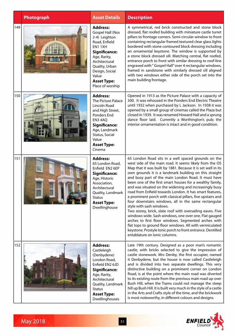
May 2018 51
Photograph Asset Details Description
149 Address:Gospel Hall (Nos 2-4) Leighton Road, Enfield EN1 1XH Significance:Age, Rarity, Architectural Quality, Urban Design, Social ValueAsset Type:Place of worship
A symmetrical, red brick constructed and stone block dressed, flat roofed building with miniature castle turret pillars to frontage corners. Semi-circular window to front containing rectangular framed textured clear glass lights bordered with stone contoured block dressing including an ornamental keystone. The window is supported by a stone block dressed sill. Matching central, flat roofed, entrance porch to front with similar dressing to roof-line engraved with “ Gospel Hall” over 4 rectangular windows, framed in sandstone with similarly dressed sill aligned with two windows either side of the porch set into the main building frontage.
150 Address:The Picture PalaceLincoln Road and High Street, Ponders End EN3 4AQ Significance:Age, Landmark Status, Social ValueAsset Type:Cinema
Opened in 1913 as the Picture Palace with a capacity of 500. It was rehoused in the Ponders End Electric Theatre until 1932 when purchased by L Jackson. In 1938 it was opened by a small group of cinemas called the Plaza but closed in 1939. It was renamed Howard Hall and a sprung dance floor laid. Currently a Worthington’s pub; the interior ornamentation is intact and in good condition.
151 Address:65 London Road, Enfield EN2 6EPSignificance:Age, Historic Association, Architectural Quality, Landmark StatusAsset Type:Dwellinghouse
65 London Road sits in a well spaced grounds on the west side of the main road. It seems likely from the OS Map that it was built by 1881. Because it is set well in its own grounds it is a landmark building on this straight and busy part of the main London Road. It must have been one of the first smart houses for a wealthy family, and was situated on the widening and increasingly busy road from Enfield towards London. It has smart features, a prominent porch with classical pillars, five upstairs and four downstairs windows, all in the same rectangular style with sash windows.Two storey, brick, slate roof with oversailing eaves. Five windows wide. Sash windows, one over one. Flat gauged arches to first floor windows. Segmented arches with flat tops to ground floor windows. All with vermiculated keystone. Prostyle Ionic porch to front entrance. Dentilled entablature on Ionic columns.
152 Address:Castleleigh (Denbydene)London Road, Enfield EN2 6JDSignificance:Age, Rarity, Architectural Quality, Landmark StatusAsset Type:Dwellinghouses
Late 19th century. Designed as a poor man’s romantic castle, with bricks selected to give the impression of castle stonework. Mrs Denby, the first occupier, named it Denbydene, but the house is now called Castleleigh and is divided into two separate dwellings. This very distinctive building on a prominent corner on London Road, is at the point where the main road was diverted to its existing route from the previous main road up over Bush Hill, when the Trams could not manage the steep hill up Bush Hill. It is built very much in the style of a castle in the Arts and Crafts style of the time, and the brickwork is most noteworthy, in different colours and designs.

May 2018 52
Photograph Asset Details Description
153 Address:Our Lady of Mount Carmel & St George (No 45)London Road, Enfield EN2 6DSSignificance:Architectural Quality, Landmark Status, Urban Design, Social ValueAsset Type:Roman Catholic Church
1958 of yellow brick with a square west tower rising from the narthex. Large imposing building with three distinctive Romanesque arches leading into the wide porch and front doors. Internally the building has an open airy basilican plan - five bays with simpl;e round-headed arches on columns and some Florentine Renaissance detail; the east end has barrel vaults. Designed and built by John E. Sterrett and B. D. Kaye. There has been a Catholic church in Enfield Town since 1862, firstly in a small chapel on the corner of London Road and Cecil Road, then in 1901 the first parish church was built dedicated to Our Lady of Mount Carmel. This was destroyed during the Second World War and for 18 years services were held at St George’s school.
154 Address:Boxer’s LakeLonsdale Drive, Enfield EN2 7JZSignificance:Age, Historic Association, Designed Landscape, Social ValueAsset Type:Public gardens
Originally in the grounds of South Lodge, one of the 3 lodges built for the keepers on Enfield Chase. The house was leased to William Pitt for 6 years from 1747 and was later a private school. In 1935 the estate was sold to Laing’s for housing. Boxer’s lake is all that remains of a string of fish ponds. Another waterbody remains at Lakeside, see entry number 145.
155 Address:Dowcra AqueductMaiden’s Brook south of Hoe LaneSignificance:Age, Historic AssociationAsset Type:Iron aquaduct
“The present course of the New River continues on the right crossing Maiden’s Brook in an aqueduct face in corrugated iron. This was built by Thomas Docwra of Cheshunt in 1859 and is best seen proceeding down Bulls Cross over the road bridge and taking a footpath on the left alongside Maidens Brook towards the A10. In a short distance the path crosses the end of the aqueduct and the New River continues southwards on the Docwra embankment for about a mile” Exploring The New River by Michael Essex Lopesti 1986:59This part of the New River is part of a diversion away from the Whitewebbs Estate. The aqueduct is mentioned on New River Loop information boards and walk leaflets. Rare example in the Borough.
156 Address:Bush Hill Park United Reformed ChurchMain Avenue, Enfield EN1 1DJSignificance:Architectural Quality, Landmark Status, Social Value, Aesthetic MeritAsset Type:Place of worship
Built in 1910 as the Bush Hill Park Congregational Church in an unusual Byzantine style. Main front parts of the building are faced in red brick with stone detailing with distinctive banding and checkerboard decoration. Striking presence in street. Building in very good condition and remains in use as a church. Also named the George Spicer Memorial Church. Spicer was a wealthy paper manufacturer who was a staunch supporter of the Liberal Party and Congregational Church. He was active on the local education board q.v. George Spicer School and died in 1911.

May 2018 53
Photograph Asset Details Description
157 Address:Tottenham Park CemeteryMontagu RoadN18 2NFSignificance:Age, Rarity, Historic Association, Designed Landscape, Social ValueAsset Type:Cemetery Building
The chapel is the focal point (and only landmark) of the cemetery, on the axis of the central main route through, and is also visible from Salmon’s Brook Walk, a local walking trail established by Enfield Council. It dates from the foundation of the cemetery in 1912 by the Tottenham Park Cemetery Company. The chapel is in brick with a steeply pitched slate roof; the central taller section is gabled at either end, with stone copings and a perky bell-tower with a fretted timber framework and copper spire. The east and west elevations have lower flat roofed and crenellated extensions. The windows have stone mullions (gothic arches to the upper windows) and lintels with hood moulds. The condition is very bad.
158 Address:Prayer Hall, Edmonton Western Synagogue CemeteryMontagu RoadN18 2NF Significance:Age, Rarity, Historic Association, Designed Landscape, Social ValueAsset Type:Cemetery Building
The building was described on the 1914 OS map as ‘Mortuary Hall’ but is now used as a prayer hall. It is a plain foursquare detached building of two storeys in brick with a concrete tile roof, and is the only building and only C20th landmark in this cemetery. The windows have been altered to an unsympathetic mid C20th style flush with the wall face, but the substantial entrance with its heavily decorated doors and moulded stone architrave survives. Two plaques at first floor level (one in English, one in Hebrew) record the foundation date of 10th July 1884.
159 Address:Mortuary at Federation CemeteryMontagu Road, EdmontonN18 2NFSignificance:Age, Rarity, Historic Association, Designed Landscape, Social ValueAsset Type:Mortuary
The mortuary is a very small and modest brick building assumed to date from the foundation of the Federation Synagogue in 1895 on land donated by Samuel Montagu, 1st Lord Swaythling, MP for Whitechapel from 1885- 1900, after whom Montagu Road is named (it was previously called Jeremy’s Green Lane). The mortuary is in red brick, with a tiled roof and a simple semi-circular rubbed brick arch entrance, and two windows on each of the side elevations.

May 2018 54
Photograph Asset Details Description
160 Address:St Luke’s HallMorley Hill and Hawthorn RoadEN2 0BLSignificance:Age, Landmark Status, Social ValueAsset Type:Church hall
The large and imposing Victorian church hall occupies a prominent corner site and is a distinctive local landmark, as well as providing a valuable community facility as a meeting place for various local organisations and church and other social events. In January 1896, Rev Vincent Travers Macy announced the purchase of four plots of land on the corner of Hawthorn Grove and Morley Hill to build an Institute large enough for meetings and concerts. Mr W Pywell of Hanwell was engaged as architect and the builders were L & W H Patman of Enfield. The foundation stone was laid on April 29th 1896 by the Lord Bishop of Stepney. Seven months later the building was completed at a cost of about £2,000 and in November the Bishop returned to Enfield to perform the opening ceremony. The Morley Hill entrance gave access to the Coffee Room in which it was intended that the working man could obtain a hot breakfast before going to his place of employment. The Reading room was designed as a means of good influence. There was also a Ladies Room but there is no suggestion as to how that would be used. The Institute was regarded as an ornament to the locality. From 1935 the hall was used for school dinners by the Middlesex County Council Education Committee. It was requisitioned by the Middlesex County Council as a rest centre during the Second World War. After the war, some remedial work was necessary, so it was not until 1947 that hall was back in parish use, which included amateur dramatics productions for many years. In 1963, the building was formally renamed ‘St Luke’s Hall’. Also in 1963, the caretaker’s accommodation was expanded to provide an improved living area by taking part of the Morley Hill committee room and part of kitchen. At the back of the hall, a single story flat roofed room was built with large skylights above the billiard tables used by the Men’s Club. In the late 1950s, the room was used by the church youth club and then in 1969 was converted into what became known as the ‘Coffee Bar’ for the Enfield District Council of Churches ‘Noah’s Ark’ Open Youth Club. At the same time, the building was renamed ‘St Luke’s Youth Centre’. ‘Noah’s Ark’ operated under a deed of trust until 1987. Today the hall has reverted to its original purpose of providing a community centre for the parish of Clay Hill and is used by a variety of organisations including the Scouts, keep fit classes, dog training classes and so on. In September 2006, StepStones Day Nursery took over the Coffee Bar and adjacent storage area and converted it into a private nursery for pre-school children.

May 2018 55
Photograph Asset Details Description
161 Address:Arnos ParkMorton Crescent N14Significance:Age, Rarity, Historic Association, Landmark Status, Designed Landscape, Social Value, Aesthetic MeritAsset Type:Public park
Arnos Park was the southern section of the former Arnos Grove estate (see history below). The public park was created in 1928 by Southgate Urban District Council and is now owned by Enfield Council. Its main features include: 44 acres of parkland, the Inverforth Gates (Lord Inverforth owned the Arnos Grove estate and sold the parkland to the Council), Pymmes Brook and its floodplain, remains of the abandoned New River loop, the London Underground viaduct carrying the Piccadilly Line over the Pymmes Brook valley with 34 numbered arches, an area of ancient woodland and large areas of grassland, tennis courts, a bowls club, football pitches, children’s playground, and a community orchard/garden.
162 Address:Enfield Dry Dock (Unit 9A)Waterways Business Centre, Navigation Way EN3 6JJ Significance:Age, Rarity, Historic AssociationAsset Type:Dry dock
The dry dock opens onto the water’s edge and, although small-scale, forms an important reminder of the earlier working sites along the river. Narrow boats and other pleasure craft are moored along the banks and create a lively rural scene in contrast to the housing and light industrial areas further north.
163 Address:Lee Conservancy Office Waterways Business Centre, Navigation WayEN3 6JJSignificance:Age, Rarity, Historic AssociationAsset Type:Office building
The former Lee Conservancy office of 1907 is a small informal red brick building with hipped roofs in a cruciform shape. Note the finely detailed brick arches over the windows. It presents itself as a historic gate house to the adjacent Waterways Business Centre.

May 2018 56
Photograph Asset Details Description
164 Address:Lee HouseWaterways Business Centre, Navigation Way EN3 6JJSignificance:Age, Rarity, Historic AssociationAsset Type:Dwellinghouse
Lee House, a substantial house originally of 1840-50 and with a rear block added late in the century, is probably associated with the accelerated growth of the Royal Small Arms Factory or the establishment of the waterway engineers’ yard (pre-dating the Lea Conservancy) on the site of the current British Waterways depot in the mid 19th century. Now restored, it makes a positive contribution to the area in its very visible position, even though it is now surrounded on two sides by modern houses built in its former garden. It is in brick – although the earlier block is now painted and part rendered – with rubbed arches, and deep eaves to a shallow slated roof. Its porch was removed at the time of the adjoining housing development, apparently to facilitate access to the site.
165 Address:Canal and Rivers Trust Workshops (Unit 11) Waterways Business Centre, Navigation Way EN3 6JJSignificance:Age, Rarity, Historic AssociationAsset Type:Workshop building
Mid 19th century stock brick single-storey workshop retaining all of its original features. Very good original brick detailing and pitched slate roof with original steel windows ensures the building retains its character.
166 Address:The Gables (No 87)New River Crescent, Palmers GreenN13 5NASignificance:Rarity, Historic Association, Architectural Quality, Landmark Status, Group Value, Aesthetic MeritAsset Type:Dwellinghouse
The Gables was the home of Albert Frederick Simmons, who built the Hazelwood Estate between Hazelwood Lane and Hedge Lane in Palmers Green - and many other houses in the area. It was built in 1906 for his bride - and his descendants still live in it. It is the end piece of a harmonious group, which is well known throughout the area. It is a beautifully conserved and handsome Arts and Crafts inspired building, with exposed beams and with original stained glass, including in the transom above the front door.

May 2018 57
Photograph Asset Details Description
167 Address:Oakwood Park Ice WellOakwood ParkN14 6QBSignificance:Age, Rarity, Historic Association, Asset Type:Ice store
An igloo shaped brick construction ice well in Oakwood Park, dating from around 1870. In 1870, Samuel Sugden, a homeopathic chemist purchased the land which eventually became Oakwood Park, which included a farmhouse. He renovated this building, adding a walled garden and orchard and renamed it ‘Oak Lodge’. The ice well was built in the grounds of this house. This Lodge was pulled down some time after WWI. Southgate Council purchased the 64 acres of the park in 1927, taking the name from Oak Lodge to form “Oakwood”. The Ice Well has remained in the park since the days of Oak Lodge. It’s position near the entrance to the park ensure it is seen by many of the visitors. It is not unusual to hear parents explaining it’s function to their children.
168 Address:The Drill Hall (No 1) Old Park Avenue, Enfield EN2 6PJSignificance:Rarity, Historic Association, Architectural Quality, Landmark StatusAsset Type:Dwellinghouse
Free Tudor-style building, with a very broad gable with little quirks and volutes broken by two polygonal turrets. The Drill Hall was at the heart of any Volunteer Reserve Unit, and the one in Enfield has been no exception, since it was built in 1901. Since the formation of the Territorial Force it was the facility that served as both a training establishment, administration centre and social club to generations of Territorial soldiers. The Drill Hall was built for the Enfield Company of the 1st Volunteer Battalion of the Middlesex Regiment, and during the First World War it was the drill station for F Company 7th Battalion Duke of Cambridge’s Own (Middlesex Regiment). During the Second World War it served the same for B Company 7th Battalion The Middlesex Regiment. This rare facility also played its part in promoting good relations with the local community with its large interior, ideal for meetings, exhibitions, trade fairs an social events. In 1859 the Rifle Volunteer Corps was authorised on the proviso that they provided their own arms, clothing and equipment. Corps formed in Hampstead, Barnet, Hornsey, Highgate, Tottenham and Enfield to form the 2nd Battalion Middlesex Rifle Volunteers and the 17th (North) Middlesex Rifle Volunteers.
169 Address:The Church in the Orchard Old Park Ridings, London N21 2EUSignificance:Rarity, Architectural Quality, Landmark Status, Social ValueAsset Type:Methodist church
This striking Art Deco building on a corner site is know locally as The Church in the Orchard, simply because before the houses were built at the beginning of the Twentieth Century, this land was all orchards in Salmons Brook valley. The history of the Church in the Orchard began in 1919 when a few earnest supporters of the Methodist cause banded together and met for worship in each other’s houses. The original church was opened in 1921 when the land was still used as an orchard. The site proved an excellent one, occupying as it did a central position on the junction of Old Park Ridings and Park Drive. Once Marshall Hood developed first the Park Drive and Grange Park Avenue area and then the Cheyne Walk estate, by the late thirties the number of parishioners had grown significantly. The Trustees opened a building fund in 1937 and on 18th June 1938 the foundation stone was laid.
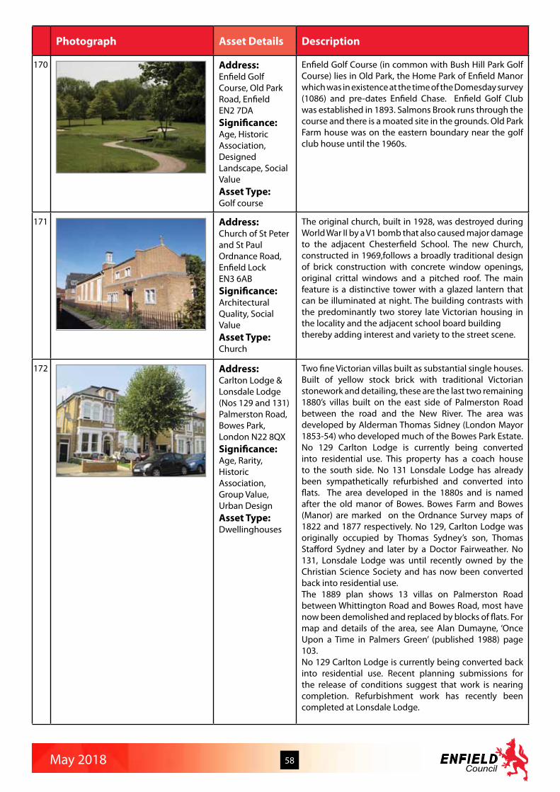
May 2018 58
Photograph Asset Details Description
170 Address:Enfield Golf Course, Old Park Road, Enfield EN2 7DASignificance:Age, Historic Association, Designed Landscape, Social ValueAsset Type:Golf course
Enfield Golf Course (in common with Bush Hill Park Golf Course) lies in Old Park, the Home Park of Enfield Manor which was in existence at the time of the Domesday survey (1086) and pre-dates Enfield Chase. Enfield Golf Club was established in 1893. Salmons Brook runs through the course and there is a moated site in the grounds. Old Park Farm house was on the eastern boundary near the golf club house until the 1960s.
171 Address:Church of St Peter and St PaulOrdnance Road, Enfield LockEN3 6ABSignificance:Architectural Quality, Social ValueAsset Type:Church
The original church, built in 1928, was destroyed during World War II by a V1 bomb that also caused major damage to the adjacent Chesterfield School. The new Church, constructed in 1969,follows a broadly traditional design of brick construction with concrete window openings, original crittal windows and a pitched roof. The main feature is a distinctive tower with a glazed lantern that can be illuminated at night. The building contrasts with the predominantly two storey late Victorian housing in the locality and the adjacent school board buildingthereby adding interest and variety to the street scene.
172 Address:Carlton Lodge & Lonsdale Lodge (Nos 129 and 131)Palmerston Road, Bowes Park, London N22 8QXSignificance:Age, Rarity, Historic Association, Group Value, Urban Design Asset Type:Dwellinghouses
Two fine Victorian villas built as substantial single houses. Built of yellow stock brick with traditional Victorian stonework and detailing, these are the last two remaining 1880’s villas built on the east side of Palmerston Road between the road and the New River. The area was developed by Alderman Thomas Sidney (London Mayor 1853-54) who developed much of the Bowes Park Estate. No 129 Carlton Lodge is currently being converted into residential use. This property has a coach house to the south side. No 131 Lonsdale Lodge has already been sympathetically refurbished and converted into flats. The area developed in the 1880s and is named after the old manor of Bowes. Bowes Farm and Bowes (Manor) are marked on the Ordnance Survey maps of 1822 and 1877 respectively. No 129, Carlton Lodge was originally occupied by Thomas Sydney’s son, Thomas Stafford Sydney and later by a Doctor Fairweather. No 131, Lonsdale Lodge was until recently owned by the Christian Science Society and has now been converted back into residential use.The 1889 plan shows 13 villas on Palmerston Road between Whittington Road and Bowes Road, most have now been demolished and replaced by blocks of flats. For map and details of the area, see Alan Dumayne, ‘Once Upon a Time in Palmers Green’ (published 1988) page 103.No 129 Carlton Lodge is currently being converted back into residential use. Recent planning submissions for the release of conditions suggest that work is nearing completion. Refurbishment work has recently been completed at Lonsdale Lodge.
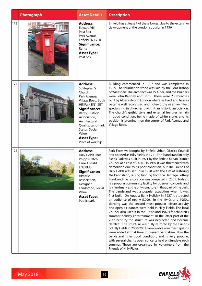
May 2018 59
Photograph Asset Details Description
173 Address:Edward VIII Post BoxPark Avenue, Enfield EN1 2HJSignificance:RarityAsset Type:Post box
Enfield has at least 4 of these boxes, due to the extensive development of the London suburbs in 1936.
174 Address:St Stephen’s ChurchPark Avenue, Village Road, Bush Hill Park EN1 2ETSignificance:Rarity, Historic Association, Architectural Quality, Landmark Status, Social ValueAsset Type:Place of worship
Building commenced in 1907 and was completed in 1915. The foundation stone was laid by the Lord Bishop of Willesden. The architect was JS Alder, and the builders were John Bentley and Sons. There were 23 churches built by Alder in North London where he lived; and he also became well recognised and noteworthy as an architect specialising in churches giving it an historic association. The church’s gothic style and external features remain in good condition, being made of white stone, and its position is prominent on the corner of Park Avenue and Village Road.
175 Address:Hilly Fields ParkPhipps Hatch Lane, Enfield EN2 0UDSignificance:Historic Association, Designed Landscape, Social ValueAsset Type:Public park
Park Farm ws bought by Enfield Urban District Council and opened as Hilly Fields in 1911. The bandstand in Hilly Fields Park was built in 1921 by the Enfield Urban District Council at a cost of £400. In 1997 it was threatened with demolition due to its poor condition, but The Friends of Hilly Fields was set up in 1998 with the aim of restoring the bandstand, raising funding from the Heritage Lottery Fund, and the restoration was competed in 2001. Today it is a popular community facility for open-air concerts and is a landmark as the only structure in that part of the park. The bandstand was a popular attraction when it was first built. On August Bank Holiday in 1927 it attracted an audience of nearly 5,000. In the 1940s and 1950s, dancing was the second most popular leisure activity and open air dances were held in Hilly Fields. The local Council also used it in the 1950s and 1960s for children’s summer holiday entertainment. In the latter part of the 20th century the structure was neglected and became derelict. The structure was fully restored by the Friends of Hilly Fields in 2000-2001. Removable wire mesh guards were added at that time to prevent vandalism. Now the bandstand is in good condition, and is very popular, with several charity open concerts held on Sundays each summer. These are organised by volunteers from the Friends of Hilly Fields.

May 2018 60
Photograph Asset Details Description
176 Address:2 Private Road, Bush Hill Park, EnfieldEN1 2ELSignificance:Age, Rarity, Architectural Quality, Landmark StatusAsset Type:Dwellinghouse
No 2 Private Road is unique in that it shows on an OS Map in 1896 (see photo) as one of the first houses built in Private Road and it is set in unusually large grounds, again as shown on the Map and which are still part of the house today. It is now hidden behind extensive trees and bushes, but nevertheless it is designated a landmark building with most of its original features intact in the Bush Hill Park character appraisal as a substantial Arts and Crafts style villa.
177 Address:Pymmes MewsPymmes Road, Palmers GreenN13 4PFSignificance:Age, Rarity, Group Value, Urban DesignAsset Type:Mews stables converted to dwellinghouses
Pymmes Mews is a row of converted mews stables off Pymmes Road and backing onto the houses/shops facing the Bowes Road, part of the busy North Circular Road. Mews are very rare in this residential area and these have been sensitively refurbished to house small businesses. Many original features have been retained including some roof finials and weatherboarding.
178 Address:7 and 9 Queen Annes Place, Bush Hill Parade,Enfield EN1 2QTSignificance:Age, Rarity, Architectural QualityAsset Type:Shop
Tiled shopfront that survives in its original form. Described in the Character Appraisal for Bush Hill Park as being built in the period 1896-1914 and with most of its original features intact. The shopfront, the last surviving example of its type in the short parade of shops,is noted (in the Character Appraisal) as making a positive contribution to the area.
179 Address:Ridge Avenue LibraryRidge Avenue,N21 2RHSignificance:Landmark Status, Urban Design, Social ValueAsset Type:Public library
Unique ‘rollercoaster’ roof unusual type in England at this time using timber hyperbolic shells covered in copper. L shaped building, red and yellow brick facing above a flint plinth. Would have been built in 1939, but prevented by the war, land disputes, financial restrictions and other crises. Opened by Mayor Cr. J. E. Cooke, Saturday 20th April 1963. Architect: T. Austin Wilkinson, ARIBA.

May 2018 61
Photograph Asset Details Description
180 Address:Chimneys Lodge (formerly the Goat Public House) Russell RoadEN2 9EHSignificance:Architectural Quality, Landmark Status, Aesthetic MeritAsset Type:Public house, now dwellinghouse
The Goat pub opened on this site in 1929 replacing the earlier pub of the same name on the corner of Goat Lane. It was built in the mock-Tudor style popular at the time in the London suburbs, with half-timbered upper storeys and very ornate chimneys modelled on those at Hampton Court. In the 1950s “The Goat” was the terminus for two local bus routes, the 144B (later 231) and 135 (later 191). This ceased when Forty Hill road was closed at the junction with Clay Hill and Baker Street, and Myddleton Avenue was opened up to through traffic heading for the A10. In the early 21st century the pub closed and the building was converted to flats, retaining most of the architectural features of the original building, including the distinctive Tudor style chimneys hence its current name, but with additional buildings to the rear. It remains a distinctive and attractive landmark in Forty Hill.
181 Address:Elim Pentecostal Chapel (No 64)Russell Road, London N13 4RPSignificance:Age, Rarity, Historic Association, Architectural Quality, Landmark Status, Social ValueAsset Type:Place of worship
Built in 1896, and shown on the 1912 OS map as the Mission Hall, this is a traditional Victorian non conformist church serving the Bowes Park area. Built of London stock brick with stone detailing and a pitched roof. The building was designed to match the surrounding Victorian residential developments, The building faces Russell Road with the New River to the rear. The rear elevation is visible from the New River path and has less detailing. There is a small 1960s flat roof extension to the rear that provides a kitchen/servery for the Church. Otherwise there have been few alterations. As Bowes Park was developed in the 1870s on the site of the Bowes Manor Estate, a Church of England Church (St Michaels at Bowes), was completed to serve the area in 1874. That Church in Palmerston Road was replaced by a modern church in 1988. As the area developed and the population grew, non conformist churches developed to provide an alternative place of worship to the established church. The Riverside Elim Chapel in Russell Road is the first and only remaining Victorian Church building in the area, Built originally for the Baptists, it soon passed to the Wesleyan Methodist Church. Originally called St Georges Hall, the building passed to the Brethren in 1934. Now in use since 1955 by the Elim Pentecostal Church. Some locals still refer to the building as St George’s Chapel. The foundation stone records that it was laid by Mrs M Mellor on 21st September 1896. The architect was William Smith of 65 Chancery Lane and the builder Charles Peak Of Hornsey.
182 Address:St Thomas ChurchSheringham Avenue, Oakwood, London N14 4SNSignificance:Architectural Quality, Landmark Status, Social ValueAsset Type:Place of worship
This church is a distinctive feature on the triangular junction between Prince George Avenue and Sheringham Avenue, its tall, narrow spire surmounted by a cross being visible from a distance. It is a good example of a modern church by a respected architect. It features some tall rectangular windows, some containing stained glass and some with a ladder feature reminiscent of Charles Rennie Mackintosh, and there are also small and large arched clerestory windows. The church is a evangelical one, arranging many activities for its local community.

May 2018 62
Photograph Asset Details Description
183 Address:Silver Street, EnfieldEN1 3XYSignificance:Age, Architectural Quality, Landmark Status, Social ValueAsset Type:Civic Centre
Landmark civic building in central Enfield. Built as the first stage of a winning design. The site has been in the Council’s possession since 1939.The design for a new civic centre was the result of an open competition held in 1957 won by the architect Eric G. Broughton. The competition called for a scheme of two units; an office block and council suite, and a town hall. After the public announcement of the competition, 427 applications were received. The Architect & Building News 1961 stated that ‘The Council are to be congratulated on the number and standard of the entries. The general average standard of the entries is high and a large number of designs have merited close and detailed examination in the final stages of adjudication.’ The first phase of the Civic Centre, completed in 1961(now referred to as D block), is of strong linear design and well considered details (including slate window reveals) and comprises of a yellow brick wing projecting over a blue brick base. The building consists of two blocks, a two-storey office block to the front of the site and, behind, the square council chamber block, committee rooms and Mayoral Suite. The two units are connected at first floor level by an enclosed bridge. In front of the building is a bronze sculpture of the Enfield Beast by R. Bentley Claughton. The New River loop passes through the site and has been piped to run into a large pool running the length of the building.‘Enfield can be very satisfied with this design, which is in fact the only worthwhile civic building to go up in Greater London since the war’ - Modern Buildings in London, Ian Nairn (London Transport, 1964).
184 Address:Nos 41 and 43 Silver Street EN1 3TDSignificance:Age, Architectural Quality, Group ValueAsset Type:Offices and residential
Late C19th three storey mixed use building, shown on map dated 1896. Three bays, stone ground floor with central tripartite sash window and entrance doors with pilasters and pediments to left and right.. London stock brick to first and second floors. Dentilated cornice below parapet. Ground floor in commercial use; upper storeys residential. No 43 sympathetically extended to the north, on three storeys. Ground floor of 43, and extension, incorporates Ada Turkish restaurant.
185 Address:Blake and Horlock clock at No 27Silver Street, Enfield EN1 3EFSignificance:Age, Rarity, Aesthetic MeritAsset Type:Clock
Early 20th century art deco clock above shop front. Clock is labelled ‘Gensign’ , a trade name of General Signal and Time Systems Co. Ltd of 73 Gt. Peter Street, London, SW1 (no longer in existence). They did not produce clock mechanisms themselves but bought them in from Solari, Electrozeit and Magneta and re-badged them. There were several planning applications to fit similar clocks in Hammersmith and Fulham between 1949 and 1965.

May 2018 63
Photograph Asset Details Description
186 Address:Nicon House (No 45) Silver Street, Enfield EN1 3EFSignificance:Age, Historic Association, Aesthetic MeritAsset Type:Church School of Industry
A red brick, stone-dressed building of 1876 with vestiges of Tudor style which was common for school buildings a little earlier in the century. Housed the Church School of Industry between 1876 and 1909 [Ref: Enfield’s Architectural Heritage (1977) by Valerie Carter, Peter Perryman and Alan Skilton. Also The Buildings of England - London 4: North by Bridget Cherry and Nickolaus Pevsner.] School was established (in a different location, moved to this new building in Silver Street in 1876) in 1806 by the Dissenters in Baker Street. Funded from dividends on stock and interest, annual subscriptions, donations and money derived from needle-work done in the school. The girls are nominated by subscribers in rotation: forty are admitted free of whom 35 are clothed. Instructed in principles of the Church of England and taught reading, writing, arithmetic, plain work and knitting, washing and household work and prepared for service [Ref: Historical Notices of Enfield, J. Tuff 1858]. The school was a charity institution administered by the vicar and a committee of seven ladies. Its object was the free education of girls between nine and fifteen. It closed in 1909. The building later housed Miss Bagshawe’s boys preparatory school. Between the wars it was acquired by the Gazette in whose possession it remained until 1984. [Ref: newspaper article - Trained to Serve - Enfield Past and Present, 15/05/75. Geofrey Hathey’s Sketchbook. Words by ‘Townsman’.]
187 Address:Lloyds Bank TSB (Nos 1 to 2)1 Silver Street, Enfield Town EN1 3EESignificance:Age, Historic Association, Architectural Quality, Landmark Status, Social ValueAsset Type:Bank
Lloyds Bank is an restrained building constructed of stone to the first floor and red brick and stone dressings above . It has an impressive stone canopied doorway at the corner of Silver Street and Southbury Road although this now difficult to see beyond the plethora of traffic lights and barriers and the crowds of people on the narrow pavement. It is older than might be thought having been constructed in 1886 (pre-dating Barclays by some 11 years) as a branch of Lloyds, Barnetts and Bosanquets Bank Limited, the head office of which was at 62 Lombard Street in the City of London. Col Bosanquet, who lived at “Claysmore” in Clay Hill became a director of this company when Lloyds amalgamated with the Bank in which he had been a partner. A robust three storey red brick building, with stone dressings and a stone-faced rusticated ground floor, and steep tiled roof with dormers. It has two principal elevations, the entrance on a splay between them, under a carved stone shell hood. The building retains its original use and character and makes a significant statement on the corner of Southbury Road and Silver Street, and in the views from adjoining roads. It is one of a series of bank buildings in the town centre (not all in their original use), which act as ‘punctuation’ and as landmarks in the street scene because of their scale, quality of detail and materials and confident design - compare Barclays Bank at 20 The Town, No. 6-7 The Town (built as a bank), and Haart of Enfield at 38 Southbury Road (also built as a bank, and proposed for inclusion).
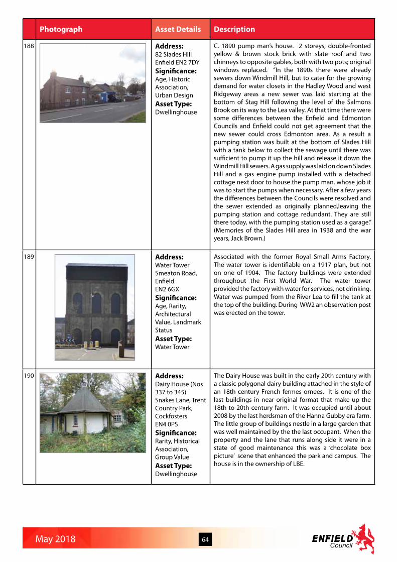
May 2018 64
Photograph Asset Details Description
188 Address:82 Slades HillEnfield EN2 7DYSignificance:Age, Historic Association, Urban DesignAsset Type:Dwellinghouse
C. 1890 pump man’s house. 2 storeys, double-fronted yellow & brown stock brick with slate roof and two chinneys to opposite gables, both with two pots; original windows replaced. “In the 1890s there were already sewers down Windmill Hill, but to cater for the growing demand for water closets in the Hadley Wood and west Ridgeway areas a new sewer was laid starting at the bottom of Stag Hill following the level of the Salmons Brook on its way to the Lea valley. At that time there were some differences between the Enfield and Edmonton Councils and Enfield could not get agreement that the new sewer could cross Edmonton area. As a result a pumping station was built at the bottom of Slades Hill with a tank below to collect the sewage until there was sufficient to pump it up the hill and release it down the Windmill Hill sewers. A gas supply was laid on down Slades Hill and a gas engine pump installed with a detached cottage next door to house the pump man, whose job it was to start the pumps when necessary. After a few years the differences between the Councils were resolved and the sewer extended as originally planned,leaving the pumping station and cottage redundant. They are still there today, with the pumping station used as a garage.” (Memories of the Slades Hill area in 1938 and the war years, Jack Brown.)
189 Address:Water TowerSmeaton Road,EnfieldEN2 6GXSignificance:Age, Rarity, Architectural Value, Landmark StatusAsset Type:Water Tower
Associated with the former Royal Small Arms Factory. The water tower is identifiable on a 1917 plan, but not on one of 1904. The factory buildings were extended throughout the First World War. The water tower provided the factory with water for services, not drinking. Water was pumped from the River Lea to fill the tank at the top of the building. During WW2 an observation post was erected on the tower.
190 Address:Dairy House (Nos 337 to 345) Snakes Lane, Trent Country Park, Cockfosters EN4 0PSSignificance:Rarity, Historical Association, Group ValueAsset Type:Dwellinghouse
The Dairy House was built in the early 20th century with a classic polygonal dairy building attached in the style of an 18th century French fermes ornees. It is one of the last buildings in near original format that make up the 18th to 20th century farm. It was occupied until about 2008 by the last herdsman of the Hanna Gubby era farm. The little group of buildings nestle in a large garden that was well maintained by the the last occupant. When the property and the lane that runs along side it were in a state of good maintenance this was a ‘chocolate box picture’ scene that enhanced the park and campus. The house is in the ownership of LBE.

May 2018 65
Photograph Asset Details Description
191 Address:Trent Park Stable BlockSnakes Lane, Trent Country Park, Cockfosters EN4 0PSSignificance:Age, Rarity, Historic Association, Architectural Quality, Group ValueAsset Type:Stables
The stable block stands on the southern ridge overlooking the mansion, which is a Grade II listed building set in the historic landscape. In the 1860s the stables were extended in the Victorian Gothic style by the Bevan family, to form the current courtyard. The Victorian buildings have polychromatic brickwork and heavy cast iron windows many of which have survived in their original form. The block also has a Victorian post box set into the wall. The building is an important element in the setting of the mansion. Unusual design and group value with the mansion. Sometimes attributed to the ‘rogue Goth’ architect S.S Teulon.
192 Address:St Matthews Church and SchoolSouth Street, Ponders EndEN3 4LASignificance:Age, Architectural QualityAsset Type:Church and school
St Matthew’s Church built in 1877/78 as a chapel of ease to St James’s Enfield Highway. Nave and north aisle survive from the original building, which was designed by H. J. Paul. Chancel added in 1900 to designs by J. E. K. and J. P. Cutts. Gothic building of Kentish Ragstone. St Matthew’s School built in 1840 as the Ponders End National School. St Matthew’s Church built later on a site next door . Original building extended considerably, but South Street frontage remains the 1840 original.
193 Address:Bush Hill ParkSouthbury Road/Lincoln Road EN1 1PSSignificance:Designed Landscape, Social ValueAsset Type:Public park
Bush Hill Park was opened as Bush Hill Recreation Ground by Enfield UDC in 1908. It has formal gardens and some rose beds, with avenues of trees and some fine trees including horse chestnuts and oaks. The Bush Hill area was once part of Old Park Estate, a Royal property pre-dating Enfield Chase and the Domesday survey of 1086. In 1660, Charles II granted the estate to General George Monck, Duke of Albemarle and it subsequently passed through many owners, until it was broken up for building in 1871.

May 2018 66
Photograph Asset Details Description
194 Address:George Spicer SchoolSouthbury Road, Enfield EN1 1YFSignificance:Historic Association, Architectural QualityAsset Type:Board school
A fine example of a pre First World War school building, the original entrances for both boys and girls. The school opened in 1912. Named after George Spicer who first became a member of the Enfield School Board in the late 19th century. According to archive material Mr Spicer was an active member of the community starting as deacon of Christ Church Congregational Church. Bush Hill Park church in Main Avenue was constructed largely at his expense in 1910 and later given the additional name of the George Spicer Memorial Church. He campaigned for the establishment of a school board in Enfield. He had been on the Enfield School Board since March 1894 and was its chairman from 1897 to 1903. Mr Spicer was then elected chairman of the Enfield Education Committee from1903 until he retired in 1907. He died in 1911 at the age of 56. In recognition for the work that he had done for Enfield schools it was decided to name the new school after him. During the First World War soldiers were billeted in the school and their guns and wagons were parked on the playing fields nearby. In the Second World War, many children who lived west of the Great Cambridge Road were not evacuated, as the authorities deemed this a safe area. During the blitz, when there were several heavy air raids near the school, the children and teachers would go down to the air raid shelters under the playground, and even have lessons down there.
195 Address:Southbury railway stationSouthbury Road,Enfield EN3 4HWSignificance:Age, Historical Assocation, Landscape Status, Social ValueAsset Type:Train station
The line from Bury Street Junction, north of Edmonton Green, to Cheshunt was opened by the Great Eastern Railway on 1st October 1891 when this station opened, it was then known as Churchbury and the line known as the Churchbury Loop. The area was still predominately rural, and the extension of the tram service to nearby Waltham Cross in 1904 severely affected passenger numbers leading to the withdrawal of passenger services on the loop on 1st October 1909. The line was reopened during the First World War to serve munitions workers between 1 march 1915 and 1 July 1919 but was then closed again and used only for goods until it was electrified and reopened as Southbury Station in 1960. The shaped central gable and the chimney stacks are particularly fine. The station building straddles the tracks below, sitting on the overbridge which carries the Southbury Road, staircases descending to the platform which retain most of their generous canopies with original late Victorian cast iron columns and decorative brackets (the southern sections of both canopies were removed c1985 but the full height brick walls remain).

May 2018 67
Photograph Asset Details Description
196 Address:Road sign fingerpostSouthgate Circus N14 5PWSignificance:Age, RarityAsset Type:Cast iron directional fingerpost sign
One of five surviving examples in Enfield of the historic cast iron finger post signs directing traffic to long standing settlements which remain important destinations in the modern Borough.
197 Address:Road sign fingerpostSouthgate GreenN14 6EN Significance:Age, RarityAsset Type:Cast iron directional fingerpost sign
One of five surviving examples in Enfield of the historic cast iron finger post signs directing traffic to long standing settlements which remain important destinations in the modern Borough.
198 Address:New Southgate Sorting OfficeSpringfield RoadN11 1RWSignificance:Age, Rarity, Architectural QualityAsset Type:Postal sorting office
An intriguing Edwardian sorting office, built around 1910. Postal sorting office purpose designed by the Office of Works and built around 1910. Single storey building with red brick main entrance block, and stone arched door surround, dentilated pediment, cornice and blocking course. The main sorting hall is in pebble dash render with red brick piers, quoins and window heads and has six bays two of which have slightly advanced shaped gables. Slate roof with two cupola ridge vents. Well preserved and still in use.

May 2018 68
Photograph Asset Details Description
199 Address:Bush Hill Park Hotel (No 141) St Mark’s Road, Bush Hill Park, Enfield EN1 1BJEN1 1BASignificance:Age, Architectural Quality, Landmark Status, Urban Design, Social ValueAsset Type:Public house
Public house property with commanding presence, erected 1897, constructed of red and bold white/cream plaster moldings over brickwork and includes an annex to the rear with central lantern and Grecian portico influenced lintel over a curved bay window. Corner situated featuring two 3 floor bays with rectangular cross-section with inlaid wood paneled gables and a central corner 3 floor cylindrical turret bay with conical section roof and weather vein. Main roof includes gables for roof rooms. Open balcony style corridor on first floor above two side by side arched entrance porches. Windows are rectangular with square over lights featuring cross members. The Bush Hill Park Hotel is a landmark building set in a focal point. The earliest record of a publican is Frederick Naylor in 1899. The Hotel is designed in the Arts and Crafts style and has many of its original features intact, including a veranda, elaborate casement windows and a corner turret. It is a large and a tall building set on a slight hill and is prominent in long distance views across the single-storey lock-up shops around the station. The hotel also dominates the station forecourt, providing a focus for the small retail area on the west side of the railway just outside the Conservation Area.
200 Address:St Mark’s Church St Mark’s Road, Bush Hill Park, Enfield EN1 1BESignificance:Architectural Quality, Landmark Status, Social ValueAsset Type:Place of worship
Built as a chapel of ease to St Andrew’s, the permanent church replaced an iron mission of 1885. It was opened 1892, consecrated in 1893, but not finally completed until 1915. St Mark’s became a separate parish in 1903. A spacious building with nave, chancel, and north and south chapels, designed by J. E. K. and J. P. Cutts in plain Early English style and built of red brick with stone dressings. An intended north-west spire was never built. The parish is now combined with St Stephens, Bush Hill Park.

May 2018 69
Photograph Asset Details Description
201 Address:Edmonton Green Rail StationStation Approach, Lower Edmonton, N9 7AASignificance:Historical Assocation, Architectural Quality, Social ValueAsset Type:Train Station
Opened in 1872 simply as ‘Edmonton’. It was renamed ‘Lower Edmonton’ in 1883 and then ‘Edmonton Green’ in 1992. The context of Edmonton Green has changed beyond all recognition since the 1950s. Only the imposing war memorial on what is now the large roundabout has survived. In 2014-15 a new pair of lift shafts was built affording step free access between street level and platforms. The new lift towers are clad in mint green ceramic tile with an abstract pattern of forest green tiles, individual raised stainless steel lettering proclaiming the station name in vertical arrangement. The towers have been well integrated within the mid Victorian fabric and character of the original station and the east tower also complements the 1970s ticket hall. The base iof the towers is of the same yellow London stock brick as the 1872 station buildings and a new gothic pointed arched window sits below the walkway to the western tower. The northbound platform is linked to the ticket hall by the original subway and long flight of stairs which retain their attractive Victorian timber brackets to the ceiling. The Victorian station is remarkably complete at platform level, comprising matching 7 bay canopies on both platforms, both retaining their scalloped spear-profile valancing, cast-iron columns and superb brackets. Subway retains attractive tongue-and-groove timber panelling and robust timber scroll brackets over the staircases.
202 Address:65 and 67Station Road, Winchmore Hill N21 3NGSignificance:Age, Rarity Historic Association, Group ValueAsset Type:Shops
65 and 67 Station Road are two small wooden shops immediately next to the railway bridge at Winchmore Hill station. 65 appears to date from before 1896 and to have been a coal order office by 1905. It is double-gabled with a decorative facade. 67 may be later, perhaps around 1925 and was also a coal office, in the 1930s. It also may have functioned as an estate agent’s office. These buildings are rare survivals within the context of the urbanisation of the Borough. The story of these shops may be closely bound up with the development of Winchmore Hill from a village to a suburb and a much-increased requirement for commodities such as coal. These little structures form a group with Winchmore Hill Station. They appear to have served the local community in a variety of ways for around 100 years and may be part of the embedded memory of several generations. A shape that is probably 65 (the more easterly building) appears on the 1896 OS map. It does not appear on the 1867 OS map, For various reasons it is likely that its origin was associated with the arrival of the railway. Winchmore Hill Station was opened in 1871 and ‘Middle Lane’ was renamed Station Road around that time. David Hicks (‘Winchmore Hill in the County of Middlesex’, unpublished volume in Enfield Local Studies collection) records 65 as being a coal order office c 1905. He also notes that in Kelly’s Directory 1925 Herbert Clarke Ltd Coal Merchants is at 65 along with Moger and Co Ltd, Coal Merchants and wonders whether they were ‘sharing the same hut’. Hicks found 67 in Kelly’s Directory 1925 as E J Westoby estate agents and in 1938 as Moger and Co Coal Merchants. 65 is currently a florist’s shop, while 67 is a barber’s.

May 2018 70
Photograph Asset Details Description
203 Address:Rendlesham Viaduct Strayfield Road Cemetery (west of ) EN2 0UDSignificance:Architectural Quality, Landmark StatusAsset Type:Railway viaduct
Rendlesham Viaduct is an imposing local landmark, with its 14 arches rising 70ft above the bottom of the valley. Its piers were constructed of mass concrete faced with brindled brick. It was opened to rail traffic in April 1910 when the Great Northern Railway line was extended from Enfield to Cuffley. The viaduct was named after Lord Rendlesham, a local landowner. Today the view of the viaduct is partially obscured by tree growth, but a footpath from the cemetery link road runs beneath the viaduct, and the top of the viaduct is visible from the cemetery. The viaduct is maintained in good condition apart from some graffiti on the lower part of the piers by the footpath. Overhead electrification supports and wires were added in the 1970s when the line was electrified, but are not obtrusive given the scale of the structure.
204 Address:Glenwood House Strayfield Road, Enfield EN2 9JFSignificance:Age, Historic Association, Architectural Quality, Group ValueAsset Type:Dwellinghouse
Glenwood House is an attractive private dwelling originally built in 1867 as the Vicarage for St. John’s Church. It was designed by J Piers St. Aubyn, who also designed the church (now Grade II listed) The house has yellow and red polychromatic brickwork materials similar to those of the church. The building is currently in good condition. In August 1981 it was decided that the building was no longer suitable for use as the vicarage, so it was sold, and is now a private home called Glenwood House.
205 Address:5 TarnbankOakwood,Enfield EN2 7JXSignificance:Rarity, Urban DesignAsset Type:Dwellinghouse
Rare example of an unaltered two-storey pre-fabricated dwelling built shortly after the 2nd World War. Most of its contemporaries have been altered with modern windows, cladding and extensions. This example appears to have its original windows, porch and front door. Although not a typical single storey prefab this house is a survivor of the original Lonsdale Drive prefabs with vague references to Festival of Britain designs.

May 2018 71
Photograph Asset Details Description
206 Address:Bourne Methodist ChurchThe Bourne N14 6RSSignificance:Architectural Quality, Landmark Status, Social ValueAsset Type:Place of worship
This prominent set of buildings on occupies an open corner of The Bourne and Queen Elizabeth Drive and has a high tower and can be seen from a distance. The first small group of Methodists in Southgate joined together for worship at a cottage in Chelmsford Road in 1885. The group soon outgrew their first meeting place and moved in turn to a baker’s shop, a marquee, an old corrugated iron building called the Iron Chapel and, in 1891, the Wesleyan Chapel on Chase Side (near present day St Andrew’s). By the early 1920s, Southgate was changing from village to suburb with the coming of the Southgate tube station, and plans were made to move the church to a still larger site on Bourne Hill. October 1929 saw the congregation’s first worship service in its new location. Southgate Methodist Church became known locally as The Bourne Methodist Church due to its location and to distinguish it from New Southgate Methodist Church in Barnet. The rapidly expanding Sunday School meant that new rooms were built in 1937. The architects were Messrs. Brocklehurst of Manchester. The two-storey building of Martin Luther and St Augustine halls opened in 1956 and has since housed a wide variety of church and community activities. In the 1990s a major redevelopment scheme modernised the worship facilities and provided greatly improved premises now constantly in use by the church and community for worship, study, relaxation, meetings, and activities. The church is part of the Enfield Circuit.
207 Address:Broadwalk Paving The BroadwalkN14 6RASignificance:Rarity, Urban Design, Social ValueAsset Type:Footway
This is a rare surfacing of a significant stretch of road, only adopted by Southgate Urban District Council in 1938. Broad Walk links the Winchmore Hill Conservation Area with Bourne Hill, forming the south east boundary of Grovelands Park. The residents and SDC were in dispute about who was responsible for surfacing the road and pavements and reached an out of court settlement so at least at this time the pavement was evidence of local identity and coherence. The pavement is about 1 kilometre long, The bricks are 9” by 4.5” and at least 1” thick. The majority appear to be original. The bricks run for the house boundary walls to the road itself or the grass verge. Both vehicle crossovers and (less frequently) footpaths from pedestrian gates to the kerb are incorporated.

May 2018 72
Photograph Asset Details Description
208 Address:33 The GreenN21 1HSSignificance:Age, Landmark StatusAsset Type:Dwellinghouse
Built in 1840, two-storey front block with single storey rear extension, roofed in slate. This is the first commercial premises on entering The Green from the west along Broad Walk. The gable fronting the road has dentil coursed brickwork to the roof verges and a central bulls eye window. The single first floor sash has fixed decorative shutters which are not original. The chimney stack which has a decorative band around the top which matches that around the roof edges and the pot also appear to be original. The shop front has decorative capitals and corbels, and a fascia with egg and dart mouldings, which appear original, with more modern replacement below. The long single storey extension to the rear of the main shop appears to be original for the most part, but has lost its chimney stacks shown in older photographs. The building now serving as dentist practice.
209 Address:King’s Head Public House (No 1)The Green N21 1BBSignificance:Age, Architectural Quality, Landmark Status, Social ValueAsset Type:Public house
The King’s Head is an exuberant Victorian public house with an elaborate corner turret. The building dominates the western end of Winchmore Hill Green. High up on the east elevation is a stone relief in the form of a blank arch containing the profile of a male head and the name ‘Kings Head and Railway Hotel. Beneath the arch are two carved heads: full face, one on each side. This is noted separately in the existing “Monument” paper as the “Kings Head Arch” A public house has probably existed in some form on this site since 1700. The current building was rebuilt in late 1896, taking an opportunity to widen the road access into both Wades Hill and Church Hill. During the rebuild, some cottages in Church Hill were knocked down to make way for a fire station. The two distinctive arches are still in place, along with their guard stones. The fire station has been absorbed into the public house building. A recent conversion of the open area to incorporate it into the restaurant area, has maintained the arches, although they are no longer open to the street.
210 Address:Christchurch ChurchyardThe Green, Waterfall Road N14 7EGSignificance:Age, Historic Association, Archaeology Value, Designed Landscape, Social ValueAsset Type:Churchyard / Public gardens
The church, designed by Sir George Gilbert Scott, was built in 1862. There was an earlier chapel built in 1615 by Sir John Weld as a chapel of ease to All Saints at Edmonton and the site of this earlier chapel is marked out in the churchyard by an enclosed rectangular area. The churchyard contains a number of early headstones, including one to Rebecca Shrawley (d.1683) with skulls and an hourglass.

May 2018 73
Photograph Asset Details Description
211 Address:41 The GreenSouthgate N14 6ENSignificance:AgeAsset Type:Dwellinghouses
A symetrical two storey late 18th century Georgian house in yellow stock brick with slate roof. Three window openings at first floor, two at ground floor. Six panelled door under decorative fanlight. The bow window on the ground floor appears to have been added at a later date. The adjacent property, no 40 is listed Grade II.
212 Address:Water TowerThe RidgewayEN2 8QHSignificance:Age, Rarity, Architectural Quality, Landmark StatusAsset Type:Water tower
1913-14. Octagonal red brick with stone detailing and crenellated top. Lancet windows at upper level. High brick corbelling and arches below stone string course. Hood moulded stone surround to lower windows. High projecting brick plinth. Residential conversion approved.
213 Address:The HolliesThe RidgewayEN2 8AL Significance:AgeAsset Type:Dwellinghouse
Early – mid C19th stuccoed villa. Two storey, in two sections with rendered brick walls, hipped slated roof and central chimney stack. Rear addition in plain brick and slate.
214 Address:The Red House, Rectory FarmThe Ridgeway, Enfield EN2 8AASignificance:Age, Architectural Quality, Landmark StatusAsset Type:Farmhouse
The Red House is a large and handsome red brick farmhouse, c.1900, standing at the bottom of a farm track on its own in rolling countryside east of The Ridgeway. From the main road, there are lovely views across the farm fields and down towards the house in the distance.

May 2018 74
Photograph Asset Details Description
215 Address:The Highlands (No 82) The Ridgeway, Enfield EN2 8JQSignificance:Age, Architectural Quality, Landmark StatusAsset Type:Dwellinghouse
Built around 1840 in a commanding position in a generous plot. Set back from The Ridgeway it is a landmark building on a major approach road to Enfield Town. Externally it remains true to its original design. The coach house (to the side), although converted to living space, retains its original scale. Mature trees add to the setting of the house.
216 Address:The Clock Tower building, Chase Farm HospitalThe Ridgeway, Enfield EN2 8JLSignificance:Age, Historic Association, Architectural Quality, Landmark Status, Group Value, Social ValueAsset Type:Workhouse/orphanage
Opened in 1886 as Chase Farm Schools, an orphanage for workhouse children. Designed by Edmonton Union Board of Guardians own architect T. E. Knightley. Gradual closure from 1930, 1938 became an old people’s home and in 1939 a hospital. Main clock tower building housed administrative offices and master’s quarters. The Clocktower Building is currently the outpatient unit of Chase Farm Hospital, built as “Chase Farm Schools” by the Edmonton Union Board of Guardians as a workhouse / orphanage. Huge building comprised of central clocktower with wings. Built in stock brick with arched entrance way; windows, clock and date plaque (1884) above. Some historic ironwork including balustrade, overhanding lantern and finials. Roofed with a spire (lead roof?) featuring some ornamental detailing. On each side of the clocktower are three storey wings, each with a central bay - and futher wings beyond, much altered. The tower is a landmark well known to everyone in Enfield and the pointed roof is visible for some distance. The remaining Victorian buildings on this site have a great story to tell about the history of poor relief and medical care in Enfield.
217 Address:Chase Farm Probationary WardThe Ridgeway, Enfield EN2 8JLSignificance:Age, Historic Association, Architectural Quality, Group Value, Social ValueAsset Type:Probationary ward
“Chase Farm Schools” was built by the Edmonton Union Board of Guardians as a workhouse / orphanage in 1886. The site has been an NHS hospital since the 1940s. This Victorian building, on the north side on the main (Ridgeway) entrance to the Chase Farm site was built as a probationary ward block to accommodate 28 children. Children moved here from the receiving ward and stayed for another two or three weeks before entering the main school. I think it’s now the offices of the cleaning contractors MediRest. It is difficult to photograph as it is hidden behind trees from the front and obscured by fencing and tacked on, temporary additions at the back, but appears to be a mirror image of the receiving block on the south side of the entrance road. Two storeys, built in stock brick with a classical frontage, pedimented front door and stucco panels which may once have been inscribed. Attractive arts and crafts style vent set in roofline at rear.

May 2018 75
Photograph Asset Details Description
218 Address:Chase Farm Receiving Ward (Postgraduate medical centre) The Ridgeway, Enfield EN2 8JLSignificance:Age, Historic Association, Architectural Quality, Group Value, Social ValueAsset Type:Probationary ward
The Postgraduate Medical Centre of Chase Farm Hospital was built as a receiving wing for newly arrived orphans at “Chase Farm Schools”, built by the Edmonton Union Board of Guardians as a workhouse/orphanage in the 1880s. Situated on the right, as you enter the site from The Ridgeway, located just behind the single storey lodge building on the south side of the entrance way. Two storeys, built in stock brick with a classical frontage and stucco panels which may once have been inscribed. Possibly a mirror image of the Medirest building / probationary ward to the north. Later additions to north and side. Some delightful original ironwork with “pineapple” finials to the downpipes and gutter fixings in a “clubs and diamonds” design. Attractive arts and crafts style window set in roofline at rear
219 Address:The Lodge (No 127), Chase Farm HospitalThe Ridgeway, Enfield EN2 8JLSignificance:Age, Rarity, Historic Association, Architectural Quality, Landmark StatusAsset Type:Lecture theatre and boundary wall
The Chase Farm lodge building sits prominently on the south side of The Ridgeway entrance to Chase Farm Hospital. It is a single storey building with a complicated roofline with dormer windows in the roof. Built of yellow stock brick with an arched doorway with large stucco crest above. There are more recent additions at back and side. The old boundary wall adjacent, brick with cast iron railings and stone capped pillars, runs along the entire Ridgeway frontage of the hospital site.

May 2018 76
Photograph Asset Details Description
220 Address:Enfield Market House and Market Place,The Town, Enfield EN2 6LNSignificance:Age, Historic Association, Landmark Status, Group Value, Urban Design, Designed Landscape, Social ValueAsset Type:Paved public space with market house and water pump
The Market Place is an open cobbled civic space at the heart of Enfield Town. It occupies the space between St Andrew’s Church, the Kings Head Pub Barclays Bank, 20 The Town, 1-2 Market Chambers and is adjacent to the oldest part of the Grammar School in Church Walk. It contains the Market House, 1904 by Sidney M Cranfield, an octagonal timber structure on classical columns and stepped plinth with a tile roof culminating in large half ball finial, built to mark coronation of Edward VII. The ancient pump has been in the Market Place (although has moved position) for many years. The Fountain marks the centre of the old and present Enfield Town; the present market place nearby next to St Andrews church dates from 1532, prior to which it was held on a small green nearby. The former green was progressively encroached upon and now the only surviving remnant is the small paved triangular area surrounding the fountain. The fountain dates from 1884, when funds were raised, according to the inscription “Erected by public subscription 1884”. The Market Office is in the nearby Old Vestry Office (22 The Town) which is also a Grade II listed building. All these buildings have a direct connection with the Market Place which enhances their settings or gives them meaning and purpose. In 1303, Edward I granted a charter to Humphrey de Bohun, and his wife to hold a weekly market in Enfield each Monday, and James I granted another in 1616, to The Parish, for a Saturday market. At that time it was held on a smaller area in front of the Church gates which by 1648 had been extended and market buildings including stalls, the Cross, Pump and Market House had been erected. A fair was held once a year on St Andrews day in St Andrews Close and an elaborate Gatehouse erected. More stalls were built in 1656.The Market was still prosperous in the early eighteenth century. In 1721 it was leased to the landlord of the Kings Head who kept 50 Pairs of trestle tables to be set out on Saturdays, but by 1778 it seems to be failing and by 1813 it was in a sad condition and the old stone Cross had been removed (another was erected in 1826 which is now at Myddelton House). There were sporadic attempts to revive the Market: an unsuccessful one of 1778 is recorded, In 1858, J. Tuff wrote of the market “several attempts have been made to revive it, the last of which, about twenty years ago, also proved a failure, It has again fallen into desuetude and will probably never be revived”.However, this pessimism was premature as trading resumed in the 1870s and in 1904 a new wooden Market House was built to replace the stone Cross, by now decayed, which was removed to Myddelton House where it still is. By 1919 the Gazette was reporting that “on most days of the week the Market Place seems to be regarded as an area for trick cycling”. The Market still takes place in the Market Place on Thursdays, Fridays and Saturdays, and is currently undergoing another revival. It is administered by the Old Enfield Charitable Trust although the extent of the Trust’s ownership and responsibilities is not clear.Apart from the Market activities the Market Place is a traditional gathering place for the inhabitants of the area. The London Journal of 17 August 1723 records that Thomas Duncombe was pilloried there. For many years from 1688 onwards it was the setting for a bonfire on 5th November. In 1721 three men collecting wood on the Chase for the bonfire were caught and and sentenced to 3 months with hard labour and a public whipping in the Market Place, which sentence was mercifully over-turned.Information from David Pam’s “A History of Enfield” and “ The Story of Enfeld Chase”

May 2018 77
Photograph Asset Details Description
221 Address:6 and 7 The Town, Enfield EN2 6LESignificance:Age, Rarity, Historic Association, Architectural Quality, Landmark StatusAsset Type:Bank (now shop)
Late C19th, Dutch gable to front. Identified as “a building making a positive contribution to the area” in the Enfield Town character appraisal, number 7 The Town, is almost an identical match to the Barclays Bank building on the opposite side of the road. “The five storey no. 6-7 The Town – originally a bank - challenges Barclays across the crossroads today as it did in 1902. But there is an intermixing with less exuberantly detailed Victorian buildings to balance this, many stuccoed and with a plainer roof-line.”
222 Address:Barclay’s Bank (No 20) The Town, Enfield EN2 6LESignificance:Age, Architectural Quality, Landmark StatusAsset Type:Bank
1897 by W. Gilbert Scott. Exuberant Flemish Renaissance style. Three / four storey. Red brick with stone detailing. Ground floor stone faced, with decorative detailing. Arched windows. Projecting arched canopy on Corinthian columns. Dutch gables to front and side. Steep pitched slated roof with central cuppola / turret.
223 Address:32 to 35 The Town, Enfield EN2 6LSSignificance:Archaeology Value, Architectural Quality, Landmark StatusAsset Type:Shopping parade
Nos. 32-35 form a group, with no 33/34 as the four storey centrepiece of a curving façade, flanked by three storey wings (32 & 35). No 33/34 has a high parapet and heavy cornice above its attic storey; all the first floor windows are round headed and form an arcade. It is a deliberate composition that places an eye-catching feature on the corner of the street.
224 Address:38 The Town, Enfield EN2 6LASignificance:Architectural Quality, Landmark StatusAsset Type:Shop
Tall three storey building of about 1890, with two tri-partite stone or stucco windows to each of the upper floors separated by panels of dark red brick, above a generously proportioned shop front. The good quality façade has survived virtually unaltered and the building is an important focus in views east from The Town.
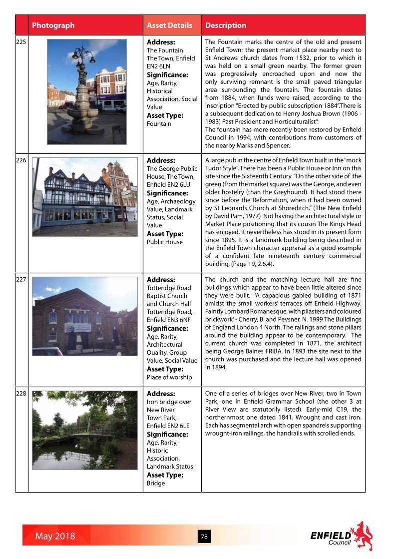
May 2018 78
Photograph Asset Details Description
225 Address:The FountainThe Town, EnfieldEN2 6LNSignificance:Age, Rarity, Historical Association, Social ValueAsset Type:Fountain
The Fountain marks the centre of the old and present Enfield Town; the present market place nearby next to St Andrews church dates from 1532, prior to which it was held on a small green nearby. The former green was progressively encroached upon and now the only surviving remnant is the small paved triangular area surrounding the fountain. The fountain dates from 1884, when funds were raised, according to the inscription “Erected by public subscription 1884”.There is a subsequent dedication to Henry Joshua Brown (1906 - 1983) Past President and Horticulturalist”.The fountain has more recently been restored by Enfield Council in 1994, with contributions from customers of the nearby Marks and Spencer.
226 Address:The George Public House, The Town, Enfield EN2 6LUSignificance:Age, Archaeology Value, Landmark Status, Social ValueAsset Type:Public House
A large pub in the centre of Enfield Town built in the “mock Tudor Style”. There has been a Public House or Inn on this site since the Sixteenth Century. “On the other side of the green (from the market square) was the George, and even older hostelry (than the Greyhound). It had stood there since before the Reformation, when it had been owned by St Leonards Church at Shoreditch.” (The New Enfield by David Pam, 1977) Not having the architectural style or Market Place positioning that its cousin The Kings Head has enjoyed, it nevertheless has stood in its present form since 1895. It is a landmark building being described in the Enfield Town character appraisal as a good example of a confident late nineteenth century commercial building, (Page 19, 2.6.4).
227 Address:Totteridge Road Baptist Church and Church HallTotteridge Road, Enfield EN3 6NFSignificance:Age, Rarity, Architectural Quality, Group Value, Social ValueAsset Type:Place of worship
The church and the matching lecture hall are fine buildings which appear to have been little altered since they were built. ‘A capacious gabled building of 1871 amidst the small workers’ terraces off Enfield Highway. Faintly Lombard Romanesque, with pilasters and coloured brickwork’ - Cherry, B. and Pevsner, N. 1999 The Buildings of England London 4 North. The railings and stone pillars around the building appear to be contemporary. The current church was completed in 1871, the architect being George Baines FRIBA. In 1893 the site next to the church was purchased and the lecture hall was opened in 1894.
228 Address:Iron bridge over New RiverTown Park, Enfield EN2 6LESignificance:Age, Rarity, Historic Association, Landmark StatusAsset Type:Bridge
One of a series of bridges over New River, two in Town Park, one in Enfield Grammar School (the other 3 at River View are statutorily listed). Early-mid C19, the northernmost one dated 1841. Wrought and cast iron. Each has segmental arch with open spandrels supporting wrought-iron railings, the handrails with scrolled ends.
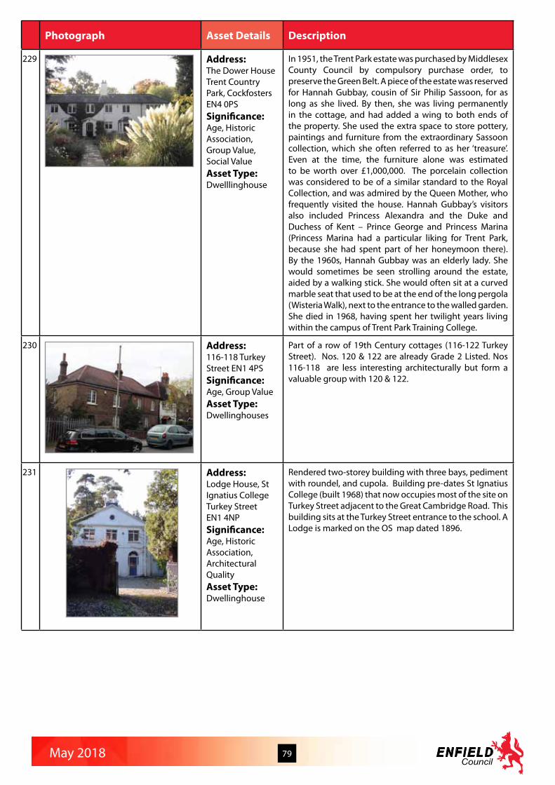
May 2018 79
Photograph Asset Details Description
229 Address:The Dower HouseTrent Country Park, CockfostersEN4 0PSSignificance:Age, Historic Association, Group Value, Social ValueAsset Type:Dwelllinghouse
In 1951, the Trent Park estate was purchased by Middlesex County Council by compulsory purchase order, to preserve the Green Belt. A piece of the estate was reserved for Hannah Gubbay, cousin of Sir Philip Sassoon, for as long as she lived. By then, she was living permanently in the cottage, and had added a wing to both ends of the property. She used the extra space to store pottery, paintings and furniture from the extraordinary Sassoon collection, which she often referred to as her ‘treasure’. Even at the time, the furniture alone was estimated to be worth over £1,000,000. The porcelain collection was considered to be of a similar standard to the Royal Collection, and was admired by the Queen Mother, who frequently visited the house. Hannah Gubbay’s visitors also included Princess Alexandra and the Duke and Duchess of Kent – Prince George and Princess Marina (Princess Marina had a particular liking for Trent Park, because she had spent part of her honeymoon there). By the 1960s, Hannah Gubbay was an elderly lady. She would sometimes be seen strolling around the estate, aided by a walking stick. She would often sit at a curved marble seat that used to be at the end of the long pergola (Wisteria Walk), next to the entrance to the walled garden. She died in 1968, having spent her twilight years living within the campus of Trent Park Training College.
230 Address:116-118 Turkey Street EN1 4PSSignificance:Age, Group ValueAsset Type:Dwellinghouses
Part of a row of 19th Century cottages (116-122 Turkey Street). Nos. 120 & 122 are already Grade 2 Listed. Nos 116-118 are less interesting architecturally but form a valuable group with 120 & 122.
231 Address:Lodge House, St Ignatius CollegeTurkey StreetEN1 4NPSignificance:Age, Historic Association, Architectural QualityAsset Type:Dwellinghouse
Rendered two-storey building with three bays, pediment with roundel, and cupola. Building pre-dates St Ignatius College (built 1968) that now occupies most of the site on Turkey Street adjacent to the Great Cambridge Road. This building sits at the Turkey Street entrance to the school. A Lodge is marked on the OS map dated 1896.

May 2018 80
Photograph Asset Details Description
232 Address:41 and 43Turkey StreetEN3 5TTSignificance:Age, Group ValueAsset Type:Dwellinghouses
Pair of cottages at 41 and 43 Turkey Street, on the footpath. They are the only survivors of a scattered group of houses on the land north of the brook. The two cottages are attached, but in an ungainly manner, as no. 43 has a hipped roof and no. 41 does not. Both have substantial central stacks. No. 43 has painted weatherboarding and small plain timber casements, while no.41 is smooth-rendered and painted white. Replacement windows have fixed lower sashes and top-hung upper lights, all with small panes, accompanied by a modern square bay and brick porch. The total effect of the two cottages is pleasantly rural and complements the brook-side setting, emphasised by the white picket fence, hedges and gardens.
233 Address:1, 3, 5, 7, 15, 17, 19 and 21 Turkey Street EN3 5TTSignificance:Age, Rarity, Group ValueAsset Type:Dwellinghouse
Modest two storey single bay houses dating from the mid 19th century, possibly associated with the steam mill formerly located between nos. 7 and 15. Their back gardens adjoin Turkey Brook. Only nos. 1 and 3 retain the original form (and only no. 1 the original fabric) of plain timber sash window with two or three panes, but all the pairs of houses retain their central stack and single hipped roof over both houses. Original materials were stock brick walls and slated roof; these are retained only by nos. 5 and 7. All houses were planned with side entrances, but some now have front doors. The houses are an important reminder of the hamlet before it was engulfed in inter-war housing development, and have group value for their relationship with the brook.
234 Address:Tyberry Road Pillbox, Tyberry Road EN3 5ABSignificance:Rarity, Historic Association, Archaeology QualityAsset Type:2nd World War pill box
Concrete/brick pillbox built 1940 for stop line in anticipation of German invasion from north. Associated anti tank blocks are still in situ.
235 Address:St Peter’s ChurchVera Ave, Enfield N21 1RJSignificance:Historic Association, Architectural Quality, Landmark StatusAsset Type:Church
Built during WWII, Farey’s church caused controversy in the local press at the time, but is a great example of architectural salvage. It is said that no new timber was used in the construction, all of it coming from London churches destroyed during the Blitz. Pews, font and choir stalls were also rescued and the church bell, dated 1785, came from St John’s, Drury Lane. Architect Cyril Farey is better known for his perspectivist architectural drawings. In the 1920s he worked with Edwin Lutyens and at one time the architectural room at the Royal Academy was so full of Farey perspectives that Lutyens called it “the Farey Glen. St Peter’s brick-built exterior, with rectangular windows, parapets and pantiles looks Scandinavian-Classical, whilst the white-plastered interior has Romanesque influence. This church demonstrates that Farey could build as well as draw.

May 2018 81
Photograph Asset Details Description
236 Address:78 Vicars Moor Lane N21 1BN Significance:Age, Architectural Quality, Group ValueAsset Type:Dwellinghouse
Identified in the Conservation Area Appraisal as being built between 1868-1896. Decorative pediment at roof level, first floor sash window with pediment over, front door with fanlight and architrave surround. Pedimented 12 light main window. Multiple sash windows to right flank. Link to No 80 set back from facia with glazed open veranda/porch over. All stuccoed and painted. The north side of the lane is of value in that it retains much of the character of a 19th century street. Most of the buildings are of yellow stock brick, with tall sash windows and slate roofs giving the area an overall cohesion. Inconsistent building lines and undulating eaves heights, coupled with a wide variety of architectural details, including deep bracketed eaves, bay windows, stone window lintels, and the occasional red brick or rendered building, result in an interesting and constantly changing streetscape. Porches are particularly diverse, ranging from formal Tuscan porticos to vernacular examples with mono-pitched tiled roofs.
237 Address:82 and 84Vicars Moor Lane N21 1BNSignificance:Age, Architectural Quality, Group ValueAsset Type:Dwellinghouses
C18th pair of cottages ( built before 1830) in red brick with stock brick fronts and slated roofs. Halls adjoining with sash windows at ground and first floor on either side.
238 Address:100 Vicars Moor Lane N21 1BNSignificance:Age, Architectural Quality, Group ValueAsset Type:Dwellinghouse
Early 19th century (pre-1830 according to the Conservation Area appraisal) Two storey, shallow hipped slate roof, stuccoed cottage. Original sash windows and glazing panel above front door.
239 Address:102 Vicars Moor Lane N21 1BNSignificance:Age, Architectural Quality, Group ValueAsset Type:Dwellinghouses
Early to mid C19th, two storey villa in yellow brick, hipped slate roof. Oversailing eaves with bracket detail. Chimney stacks. Five windows wide. Sash windows. Ground floor six over six, first floor three over three. Modern Georgian doorcase.
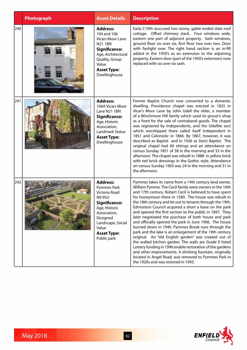
May 2018 82
Photograph Asset Details Description
240 Address:104 and 106Vicars Moor Lane N21 1BNSignificance:Age, Architectural Quality, Group ValueAsset Type:Dwellinghouse
Early C19th stuccoed two storey, gable ended slate roof cottage. Offset chimney stack. Four windows wide, eastern one part of adjacent property. Sash windows, ground floor six over six, first floor two over two. Door with fanlight over. The right hand section is an in-fill added in the 1950’s as an extension to the adjoining property. Eastern door (part of the 1950’s extension) now replaced with six over six sash.
241 Address:106A Vicars Moor Lane N21 1BNSignificance:Age, Historic Association, Landmark StatusAsset Type:Dwellinghouse
Former Baptist Church now converted to a domestic dwelling. Providence chapel was erected in 1825 in Vicar’s Moor Lane by John Udall the elder, a member of a Winchmore Hill family which used its grocer’s shop as a front for the sale of contraband goods. The chapel was registered by Independents, and the Udallite sect which worshipped there called itself Independent in 1851 and Calvinistic in 1866. By 1867, however, it was described as Baptist and in 1926 as Strict Baptist. The original chapel had 60 sittings and an attendance on census Sunday 1851 of 38 in the morning and 33 in the afternoon. The chapel was rebuilt in 1888 in yellow brick with red brick dressings in the Gothic style. Attendance on census Sunday 1903 was 24 in the morning and 31 in the afternoon.
242 Address:Pymmes ParkVictoria RoadN9 9SUSignificance:Age, Historic Association, Designed Landscape, Social ValueAsset Type:Public park
Pymmes takes its name from a 14th century land owner, William Pymme. The Cecil family were owners in the 16th and 17th century. Robert Cecil is believed to have spent his honeymoon there in 1589. The house was rebuilt in the 18th century and let out to tenants through the 19th. Edmonton Council acquired a short a lease on the park and opened the first section to the public in 1897. They later negotiated the purchase of both house and park and officially opened the park in June 1906. The house burned down in 1940. Pymmes Brook runs through the park and the lake is an enlargement of the 19th century original. An “old English garden” was created out of the walled kitchen garden. The walls are Grade II listed Lottery funding in 1996 enable restoration of the gardens and other improvements. A drinking fountain, originally located in Angel Road, was removed to Pymmes Park in the 1920s and was restored in 1993.

May 2018 83
Photograph Asset Details Description
243 Address:Bush Hill GardensVillage Road/Bush Hill Road, Winchmore Hill,EN1 2HASignificance:Designed Landscape, Social ValueAsset Type:Public gardens
Bush Hill Gardens is a small public garden laid out on land purchased by Enfield UDC in 1925. Planting and landscaping were completed in the autumn of 1928 after which the gardens were opened to the public. Near the entrances on Bush Hill Road a rock garden with pond and bridge was laid out. Much of the area was once part of the Old Park Estate, a Royal property pre-dating Enfield Chase, which was eventually broken up in 1871 and subsequently built over.
244 Address:Road sign fingerpost Village Road at junction with Park Avenue EN1 2ETSignificance:Age, RarityAsset Type:Cast iron directional fingerpost sign
One of six surviving examples in Enfield of the historic cast iron finger post signs directing traffic to long standing settlements which remain important destinations in the modern Borough.
245 Address:120 to 128 (even) Wagon RoadEN4 0PNSignificance:Age, Group ValueAsset Type:Dwellinghouses
Two storey C19th terrace of 5 dwelling houses mainly in painted pebble-dash render with many original features, including windows, brick chimneys, and slate roof with overhanging eaves and verges. At each end of the terrace are two larger dwellings with projecting gabled wings and recessed stucco rendered sections set back from main façade; three smaller dwellings between.
246 Address:Post box Wagon Road EN4 0PNSignificance:Age, RarityAsset Type:Edward VIII post box
Post boxes with this Royal cipher are rare, as Edward VIII reigned for less than a year from 20th January 1936 to 11th December 1936. After his abdication some post boxes bearing his cipher were modified or replaced. 161 were pillar boxes were made with the “EVIIIR” cipher, but it is estimated that only about 130 still survive.

May 2018 84
Photograph Asset Details Description
247 Address:6, 8, 10, 12, 14 and 16 Wakefield Road, Bounds Green N11 2SUSignificance:Age, Rarity, Architectural Quality, Group Value, Aesthetic MeritAsset Type:Ornamental cast iron porches to dwellinghouses
Substantial forecourted red brick terraced houses with distinctive and highly unusual pairs of ornamental cast iron porches with glazed roofs. Whilst there are others in the road, these have unfortunately been removed or altered unsympathetically, but these ones remain in better condition.
248 Address:Minchenden Oak GardenWaterfall Road N14 7JNSignificance:Age, Rarity, Historic Association, Designed LandscapeAsset Type:Public park
Minchenden Oak Garden was once part of the Minchenden Estate, one of the great estates in the area, owned by the Duke of Chandos. Minchenden House, which stood on the south side of Southgate Green, was demolished in 1853 by the Walker family, and the grounds incorporated into the Arnos Grove Estate. A relic of the grounds of Minchenden House remains today in the form of the Minchenden or Chandos Oak, an ancient pollarded oak tree more than 800 years old. Thought to be a survivor of the ancient Forest of Middlesex, it was reputed in the 19th century to be the largest in England with a girth of over 27 feet. Minchenden Oak Garden was created by Southgate Borough Council as an evergreen Garden of Remembrance and opened in 1934.
249 Address:Old Southgate CemeteryWaterfall RoadN14 7JSSignificance:Designed Landscape, Social ValueAsset Type:Cemetery
With Christ Church only a short distance away the cemetery has no chapel. The grounds are laid out in a gridiron pattern and there are no outstanding monuments. The only building is a lodge of 1953.
250 Address:Old School House (No 3 ) Waverley Road, Enfield EN2 7RXSignificance:Historic Association, Architectural Quality, Social ValueAsset Type:School/now flats
Built in about 1901 as a new school building for the North Middlesex High School for Girls. The facade to Waverley Road is original, with the roof overhanging the central section, between bays at each end. At the rear there are three wings, the southern one having a large bay window, a small casement window with an arched top and projecting sill, and a small bell tower surmounted by a weather vane. The central wing has a row of large skylights on each side of the roof and the northern wing has an enclosed balcony at first floor level, supported on wooden pillars. A flat-roofed extension has been added at the rear. The school was converted into 12 flats.

May 2018 85
Photograph Asset Details Description
251 Address:Walls of basin and sluice of old mill Wharf RoadEN3 4TFSignificance:Age, Historic Association, Archaeology ValueAsset Type:Sluice to water mill
C18th red brick walls. The western branch of the River Lea with the weir and sluice lies immediately to the north of the main group of buildings on the historic G R Wright Flour Mills site. The weir itself and its adjacent former wharf areas on the western branch of the millstream are also suffering from some neglect. The wharf edges have been repaired, but the weir walls have extensive loss of pointing.
252 Address:Lodge Cottage at entrance to Flour MillsWharf Road EN3 4TFSignificance:Age, Historic AssociationAsset Type:Dwellinghouse
Early 19th century. Lodge Cottage is a small square single storey building with two Gothic windows flanking the entrance door and porch, located at the entrance to G R Wright’s Flour Mills. Pebble-dash rendered external walls, slate roof and central chimney stack, the building is one of a group of historic buildings and structures on the site of to the oldest continuously working flour mill in the country (the first records of flour milling are from the 13th century). Lodge Cottage now has an unsympathetic setting comprising a security hut and barrier, their accompanying functional hardware and signs, and the car park.
253 Address:Garden walls to south west of Flour Mills Wharf Road EN3 4TFSignificance:Age, Historic Association, Archaeology Value, Social ValueAsset Type:Boundary wall
Late 18th century. The walled kitchen garden occupies the south-west corner of the historic G R Wright Flour Mills site, contained to the east by the weather-boarded and listed former barn, to the north by a high brick wall, and to the south by a lower brick wall along Wharf Road. The garden walls are stock red brick and enclose a large greenhouse and potting shed. The garden was formerly for vegetable growing and served the mill-owners; now there is a tennis court and a rough lawn, with an extensive herbaceous border along the length of the northern boundary wall against which fruit trees are espaliered and vegetables grown. The greenhouse and potting shed are the focus of the area, and, although in poor condition, are well used, and the garden is dotted with fruit trees. On its southern boundary, the garden wall is lower and is topped with razor wire, unfortunate but probably necessary to prevent vandalism. The garden walls provide a very dramatic spatial element: the garden is just visible from Wharf Road (albeit through the aggressive fringe of razor wire topping the boundary), but from the entrance drive it is a sudden revelation, hidden behind a high south facing wall and giving no hint of its existence until the small doorway is passed. The south west corner of the wall is in urgent need of repair.

May 2018 86
Photograph Asset Details Description
254 Address:Conduit HouseWhitewebbs RoadEN2 9HWSignificance:Historic Association, Architectural Quality, Landscape StatusAsset Type:Dwellinghouse
C17th. Small square brick building adjacent Lake in Wilkinsons Wood, Whitewebbs Park. Probably the pump chamber or well head for water supply to Whitewebbs House. Possible Tudor foundations.
255 Address:Whitewebbs House including stable block and garden wallsWhitewebbs RoadEN2 9HHSignificance:Historic Association, Architectural Quality, Landmark StatusAsset Type:Dwellinghouse
C18th, remodelled C19th house in Whitewebbs Wood. House built for Dr Abraham Wilkinson 1791, replacing previous building. Charles Stuart Robinson added a wing and embellishments and curved pediment to west front in 1881, giving a French chateau look. Bought by the local authority in 1931 and latterly an elderly persons home. Now a pub restaurant. Two storey, stucco. Tiled pitched gable ended roof. Chimney stacks. East front balustrade with urn finials and dentil course to eaves line. Quoin detail. Two two storey canted bays, with balconies on projecting brackets. Single storey wings at each end, with arched windows, embellished with garlands and keystones glazing with decorative glazing bars at top. Bow flank. Quion and balustrade detail carried repeated. Balustrade detail also around perimeter and up external staircase. Sash windows to first floor six over six. Stable block and garden walls.
256 Address:Pumping StationWhitewebbs RoadEN2 9HWSignificance:Historic Association, Architectural QualityAsset Type:Water pumping station
1898 New River Company pumping station, built to supply the now dry Whitewebbs Loop of the New River. Now the Whitewebbs Museum of Transport. Red brick. Single storey projecting front porch with dentilled pediment. Large arched windows. Projecting string course. Three Circular windows above. Windows with glazing bars. Slate roof. Dentilled eaves.
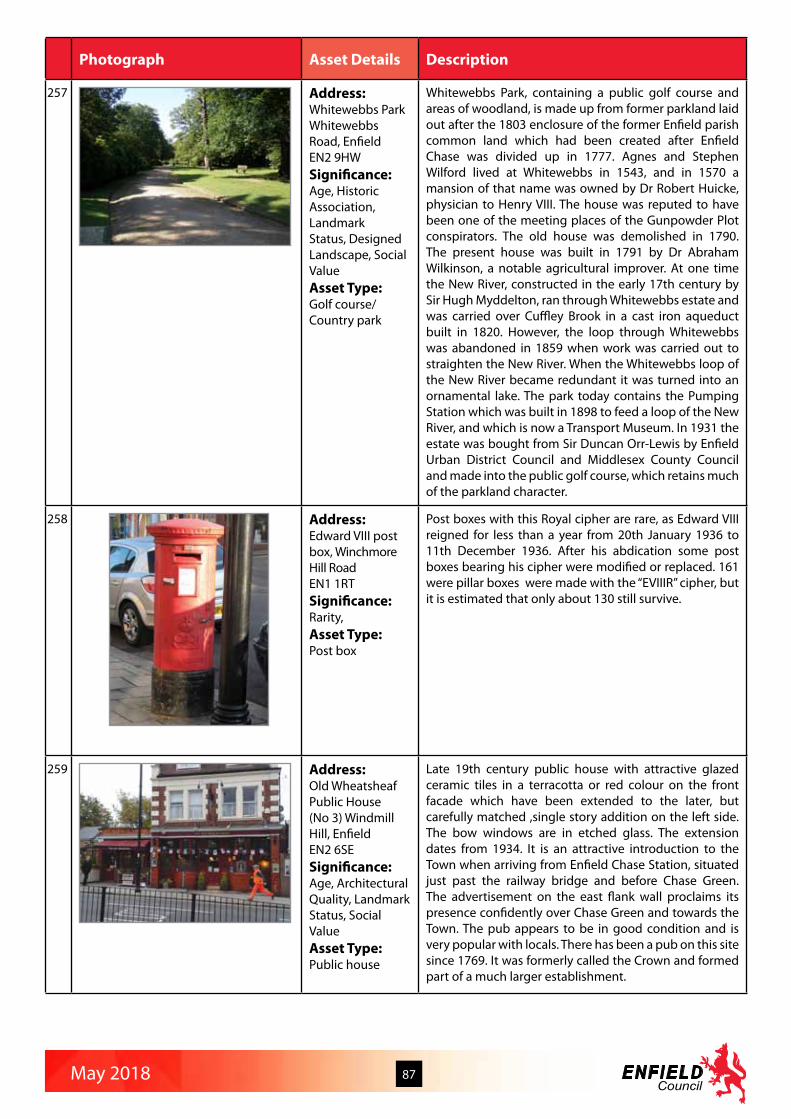
May 2018 87
Photograph Asset Details Description
257 Address:Whitewebbs ParkWhitewebbs Road, Enfield EN2 9HWSignificance:Age, Historic Association, Landmark Status, Designed Landscape, Social ValueAsset Type:Golf course/Country park
Whitewebbs Park, containing a public golf course and areas of woodland, is made up from former parkland laid out after the 1803 enclosure of the former Enfield parish common land which had been created after Enfield Chase was divided up in 1777. Agnes and Stephen Wilford lived at Whitewebbs in 1543, and in 1570 a mansion of that name was owned by Dr Robert Huicke, physician to Henry VIII. The house was reputed to have been one of the meeting places of the Gunpowder Plot conspirators. The old house was demolished in 1790. The present house was built in 1791 by Dr Abraham Wilkinson, a notable agricultural improver. At one time the New River, constructed in the early 17th century by Sir Hugh Myddelton, ran through Whitewebbs estate and was carried over Cuffley Brook in a cast iron aqueduct built in 1820. However, the loop through Whitewebbs was abandoned in 1859 when work was carried out to straighten the New River. When the Whitewebbs loop of the New River became redundant it was turned into an ornamental lake. The park today contains the Pumping Station which was built in 1898 to feed a loop of the New River, and which is now a Transport Museum. In 1931 the estate was bought from Sir Duncan Orr-Lewis by Enfield Urban District Council and Middlesex County Council and made into the public golf course, which retains much of the parkland character.
258 Address:Edward VIII post box, Winchmore Hill RoadEN1 1RTSignificance:Rarity, Asset Type:Post box
Post boxes with this Royal cipher are rare, as Edward VIII reigned for less than a year from 20th January 1936 to 11th December 1936. After his abdication some post boxes bearing his cipher were modified or replaced. 161 were pillar boxes were made with the “EVIIIR” cipher, but it is estimated that only about 130 still survive.
259 Address:Old Wheatsheaf Public House (No 3) Windmill Hill, Enfield EN2 6SESignificance:Age, Architectural Quality, Landmark Status, Social ValueAsset Type:Public house
Late 19th century public house with attractive glazed ceramic tiles in a terracotta or red colour on the front facade which have been extended to the later, but carefully matched ,single story addition on the left side. The bow windows are in etched glass. The extension dates from 1934. It is an attractive introduction to the Town when arriving from Enfield Chase Station, situated just past the railway bridge and before Chase Green. The advertisement on the east flank wall proclaims its presence confidently over Chase Green and towards the Town. The pub appears to be in good condition and is very popular with locals. There has been a pub on this site since 1769. It was formerly called the Crown and formed part of a much larger establishment.

May 2018 88
Photograph Asset Details Description
260 Address:Old Court HouseWindmill Hill, Enfield EN2 6SASignificance:Age, Historic Association, Architectural Quality, Landmark Status, Social ValueAsset Type:Court
1900 by H. T. Wakelam. One storeyed of red brick with quite ornate stone dressings and a central shaped gable. [Ref: The Buildings of England - London 4:North by Bridget Cherry and Nickolaus Pevsner, 1998.] The Court House, Windmill Hill was first used in September 1900. Landmark building at an important junction. The brick wall and railings have been altered and cut back so that the Court House is now on the corner of Old Park Avenue since c. 1913. [Ref: Enfield Through Time by Stephen Sellick.] Now houses Enfield office of the National Probation Service.
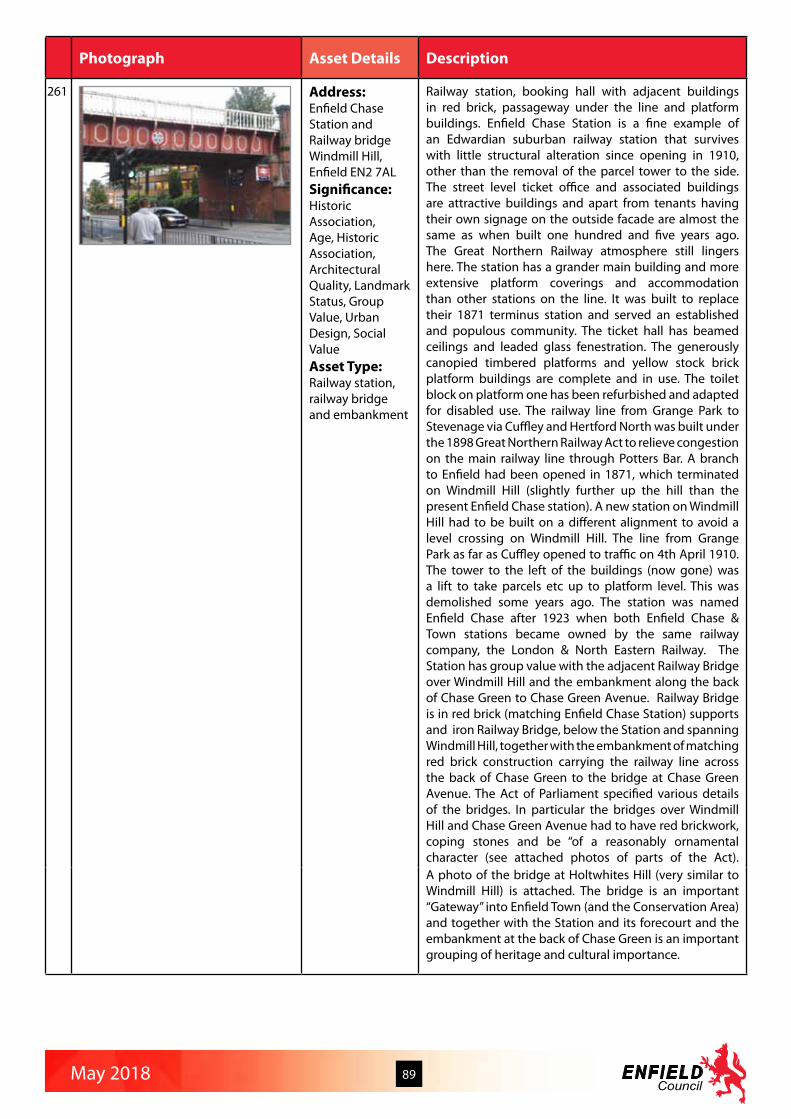
May 2018 89
Photograph Asset Details Description
261 Address:Enfield Chase Station and Railway bridgeWindmill Hill, Enfield EN2 7ALSignificance:Historic Association, Age, Historic Association, Architectural Quality, Landmark Status, Group Value, Urban Design, Social ValueAsset Type:Railway station, railway bridge and embankment
Railway station, booking hall with adjacent buildings in red brick, passageway under the line and platform buildings. Enfield Chase Station is a fine example of an Edwardian suburban railway station that survives with little structural alteration since opening in 1910, other than the removal of the parcel tower to the side. The street level ticket office and associated buildings are attractive buildings and apart from tenants having their own signage on the outside facade are almost the same as when built one hundred and five years ago. The Great Northern Railway atmosphere still lingers here. The station has a grander main building and more extensive platform coverings and accommodation than other stations on the line. It was built to replace their 1871 terminus station and served an established and populous community. The ticket hall has beamed ceilings and leaded glass fenestration. The generously canopied timbered platforms and yellow stock brick platform buildings are complete and in use. The toilet block on platform one has been refurbished and adapted for disabled use. The railway line from Grange Park to Stevenage via Cuffley and Hertford North was built under the 1898 Great Northern Railway Act to relieve congestion on the main railway line through Potters Bar. A branch to Enfield had been opened in 1871, which terminated on Windmill Hill (slightly further up the hill than the present Enfield Chase station). A new station on Windmill Hill had to be built on a different alignment to avoid a level crossing on Windmill Hill. The line from Grange Park as far as Cuffley opened to traffic on 4th April 1910.The tower to the left of the buildings (now gone) was a lift to take parcels etc up to platform level. This was demolished some years ago. The station was named Enfield Chase after 1923 when both Enfield Chase & Town stations became owned by the same railway company, the London & North Eastern Railway. The Station has group value with the adjacent Railway Bridge over Windmill Hill and the embankment along the back of Chase Green to Chase Green Avenue. Railway Bridge is in red brick (matching Enfield Chase Station) supports and iron Railway Bridge, below the Station and spanning Windmill Hill, together with the embankment of matching red brick construction carrying the railway line across the back of Chase Green to the bridge at Chase Green Avenue. The Act of Parliament specified various details of the bridges. In particular the bridges over Windmill Hill and Chase Green Avenue had to have red brickwork, coping stones and be “of a reasonably ornamental character (see attached photos of parts of the Act).A photo of the bridge at Holtwhites Hill (very similar to Windmill Hill) is attached. The bridge is an important “Gateway” into Enfield Town (and the Conservation Area) and together with the Station and its forecourt and the embankment at the back of Chase Green is an important grouping of heritage and cultural importance.

www.enfield.gov.uk