Embed Size (px)
DESCRIPTION
Selected Works 2010 - 2015
Citation preview
1
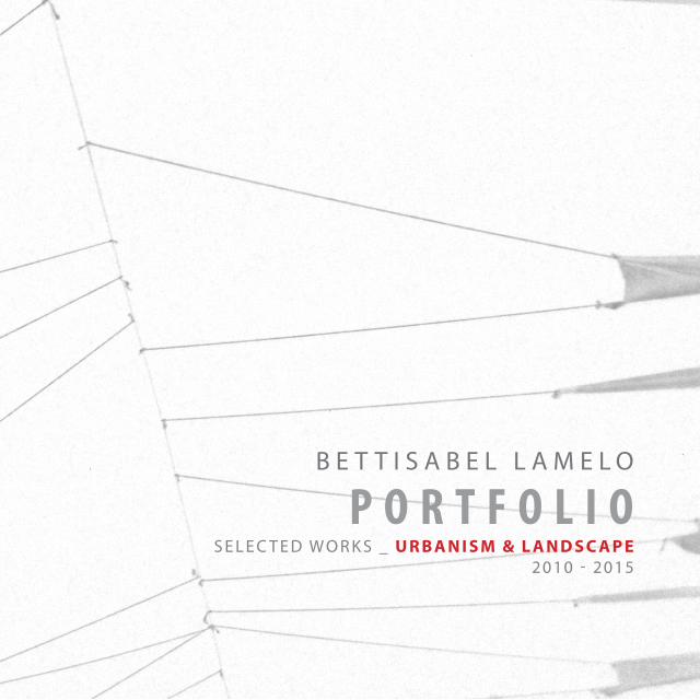
B E T T I S A B E L L A M E L O
P O R T F O L I OS E L E C T E D W O R K S _ U R B A N I S M & L A N D S C A P E
2010 - 2015
2
B E T T I S A B E L L A M E L O V I Ñ A
+ I N F OC V [email protected] | 03.03.89
+34 617691135 | Barcelona, España
E D U C AT I O N
P R O F E S S I O N A L E X P E R I E N C E
T E A C H I N G E X P E R I E N C E
L A N G U A G E S
R E C O G N I T I O N S & A W A R D S
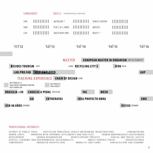
Universitat Politècnica de Catalunya / TU Delft | EMU European Postgraduate Master in UrbanismNational University of Singapore | IFoU International Forum of Urbanism - Winter School 2015Università IUAV di Venezia | Recycling City 3 WorkshopUniversitat Politècnica de Catalunya | Summer International Workshop TE’ETSAB.11 BeSIDES TOURISMUniversidad Simón Bolívar | Architect - CumLaude Mention
Best Student 2011 | Universidad Simón BolívarHonorable Mention | Final Bachelor Project: Inhabitating the limit Best Projects USB 2012 | Final Bachelor Project: Inhabitating the limit Best Projects USB 2011 | Projects: Abonador Mirador & Cosiendo el TerritorioBest Projects USB 2010 | Project: Office Tower Best Projects USB 2009 | Project: Cultural House in Choroní
Urbanism & Public Space Project - Oncological and Cardiological Hospital | Architect & Urban PlannerLAB.PRO.FAB | Architect | http://www.labprofab.com/Puchetti Arquitectos | Architecture Intern | http://www.puchettiarquitectos.com/Good Urban Practices (GUP) | Founder & Editor in Chief
Chair of Design - Level II - Universidad Simón Bolívar | Visiting Professor
Spanish | Native English | Advanced, TOEFL 111/120 Catalán | Basic
2013-2015Jan 2015
Jun-Jul 2014 Jul 2011
2006-2011
2012-2013Dec 2011-Jul 2013
Mar-May 2011Dec 2015-present
Apr-Jul 2013
3
P U B L I C AT I O N S
S E M I N A R S A N D E V E N T S
C O M P E T I T I O N S
S K I L L S A N D C O M P E T E N C E S
Projecting the Territory publication | European Postgraduate Master in UrbanismIdea Proyecto Obra (Idea Project Work), Recent architecture in Venezuela, Project: Tiuna el FuerteEntreRayas Magazine | Final Bachelor Project with honorable mention: Inhabitating the limit SAI Salón de Arquitectura Interior | Final Bachelor Project Exhibition - USB StandEntreRayas Magazine | Best Projects USB 2009 | Project: Cultural House in Choroní
Social and Organizational Skills | Excellent Communication skills - Multitasking - Teamwork - Ability to lead groups - Solid time management skills
Artistic | Freehand drawing, painting, sculpture, dancing and singingStudies: Singing (2004-2012) - Electric guitar (2004-2007) - Drums (2006-2007)
Computer Skills | Advanced: Autocad 2015 - Photoshop, Illustrator and Indesign CS7 - Sketchup Pro - Space Syntax - Movie Maker - Office | Good: ArcGIS - Revit 2015
VII International Seminar on Urban Research SpeakerForum “Footprint in architectural competitions,” 40th Anniversary of Architecture Department SpeakerIAC Iberoamerica: Architecture and City, Maracaibo VII Iberoamerican Biennial of Architecture, Medellín
Participation in Kymfield Schools CompetitionParticipation in ArchMedium Medellín Experimental Social Housing competition Participation in YAC Space to Culture competition4th Place | Caracas a Pedal competition - Bike-path design category Participation in International Competition of Ideas Brasilia +502nd Place | National Competition of Design in Steel ILAFA 2010
20152013201220122010
Jun 2015Nov 2011Feb 2011Oct 2010
201520142014201220112010
4
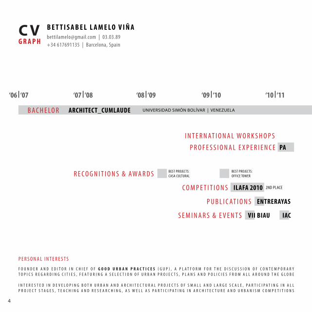
B E T T I S A B E L L A M E L O V I Ñ A
G R A P HC V [email protected] | 03.03.89
+34 617691135 | Barcelona, Spain
‘06 ‘07‘07 ‘08 ‘09 ‘10 ‘11‘08 ‘09 ‘10
B A C H E LO R ARCHITECT_CUMLAUDE UNIVERSIDAD SIMÓN BOLÍVAR | VENEZUELA
P R O F E S S I O N A L E X P E R I E N C E
R E C O G N I T I O N S & AWA R D S
C O M P E T I T I O N S
P U B L I C AT I O N S
S E M I N A R S & E V E N T S
T E A C H I N G E X P E R I E N C E
PA
ILAFA 2010
ENTRERAYAS
VII BIAU IAC
I N T E R N AT I O N A L W O R K S H O P S
2ND PLACE
BEST PROJECTS: CASA CULTURAL
BEST PROJECTS: OFFICE TOWER
F O U N D E R A N D E D I T O R I N C H I E F O F G O O D U R B A N P R A C T I C E S ( G U P ) , A P L A T F O R M F O R T H E D I S C U S S I O N O F C O N T E M P O R A R Y T O P I C S R E G A R D I N G C I T I E S , F E A T U R I N G A S E L E C T I O N O F U R B A N P R O J E C T S , P L A N S A N D P O L I C I E S F R O M A L L A R O U N D T H E G L O B E
I N T E R E S T E D I N D E V E L O P I N G B O T H U R B A N A N D A R C H I T E C T U R A L P R O J E C T S O F S M A L L A N D L A R G E S C A L E , P A R T I C I P A T I N G I N A L L P R O J E C T S T A G E S , T E A C H I N G A N D R E S E A R C H I N G , A S W E L L A S P A R T I C I P A T I N G I N A R C H I T E C T U R E A N D U R B A N I S M C O M P E T I T I O N S
P E R S O N A L I N T E R E S T S
5
S PA
E N G
C AT
L A N G U A G E S
A U T O C A D *
P S D | A I | I N D D
S K E T C H U P P R O
S PA C E S Y N TA X
A R C G I S
R E V I T *
* A U T O D E S K O F F I C I A L C E R T I F I C AT ES K I L L S
‘11 ‘12 ‘13 ‘14 ‘15 ‘16‘12 ‘13 ‘14 ‘15
M A S T E R EUROPEAN MASTER IN URBANISM UPC & TUDELFT
T E A C H I N G E X P E R I E N C E
LAB.PRO.FAB
CHAIR OF DESIGN
PA
IAC USB 40 AÑOS VIISIIU
ENTRERAYAS IDEA PROYECTO OBRA EMUSAI
YAC MESHBRASILIA +50 CARACAS A PEDAL
SELF-EMPLOYED
BESIDES TOURISM REC YCLING CITY 3 IFOUUPC
USB
SPEAKER SPEAKER
4TH PLACE
BEST PROJECTS: FINAL PROJECT
BEST PROJECTS X 2FINAL PROJECT HONORABLE MENTIONBEST STUDENT USB
NUSIUAV
# S T R E E T A S P U B L I C S P A C E # R E C Y C L I N G I N D U S T R I A L S P A C E S # R E T H I N K I N G I N F R A S T R U C T U R E # I N H A B I T A T I N G U R B A N L I M I T S # W O R K I N G W I T H I N F O R M A L S E T T L E M E N T S A N D P R A C T I C E S # U R B A N M O R P H O L O G I E S # S U S T A I N A B L E D E V E L O P M E N T # U R B A N R E G E N E R A T I O N # P A R T I C I P A T O R Y P R O J E C T S # S O C I A L A N D S P A T I A L J U S T I C E # S O C I A L , E C O N O M I C A N D E N V I R O N M E N T A L S U S T A I N A B I L I T Y # M U L T I - P U R P O S E S P A C E S # A R C H I T E C T U R A L C O M P O N E N T S # M O D U L A R A R C H I T E C T U R E # M O B I L I T Y A N D F L O W S # A R C H I T E C T U R E A N D E C O N O M Y
P R O F E S S I O N A L I N T E R E S T S
GUP
6
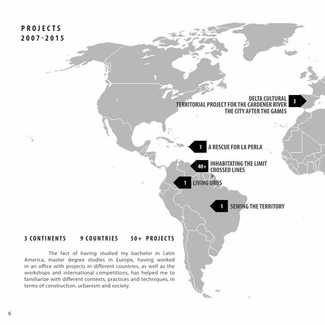
40+
1
1
1
3
The fact of having studied my bachelor in Latin America, master degree studies in Europe, having worked in an office with projects in different countries, as well as the workshops and international competitions, has helped me to familiarize with different contexts, practices and techniques, in terms of construction, urbanism and society.
LIVING URBS
INHABITATING THE LIMIT
DELTA CULTURALTERRITORIAL PROJECT FOR THE CARDENER RIVER
THE CITY AFTER THE GAMES
CROSSED LINES+
SEWING THE TERRITORY
A RESCUE FOR LA PERLA
P R O J E C T S2 0 0 7 - 2 0 1 5
3 C O N T I N E N T S 9 C O U N T R I E S 5 0 + P R O J E C T S
7
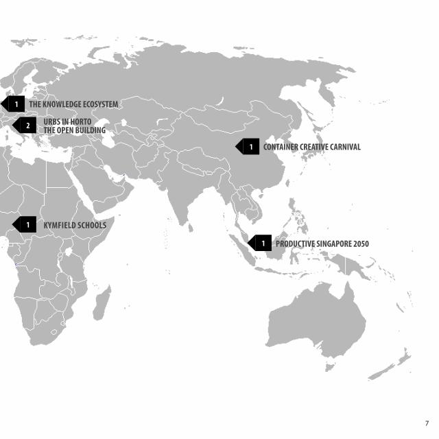
2
1
1
1
1
THE KNOWLEDGE ECOSYSTEM
URBS IN HORTO
KYMFIELD SCHOOLS
THE OPEN BUILDING
CONTAINER CREATIVE CARNIVAL
PRODUCTIVE SINGAPORE 2050
8
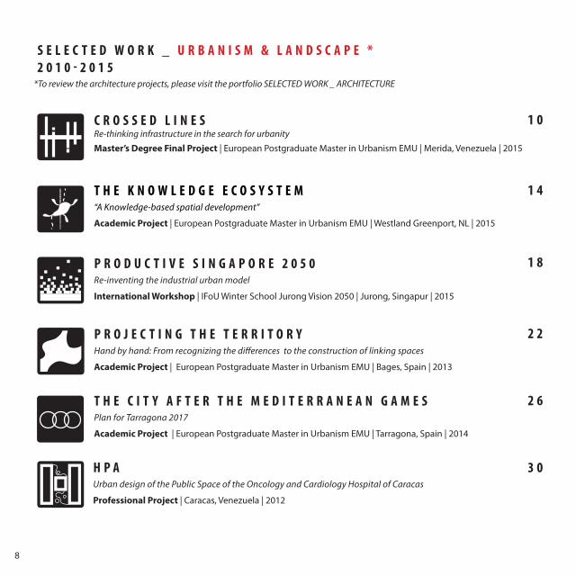
S E L E C T E D W O R K _ U R B A N I S M & L A N D S C A P E *2 0 1 0 - 2 0 1 5
1 0
1 4
1 8
2 2
2 6
3 0
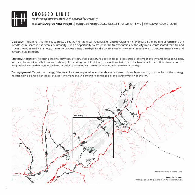
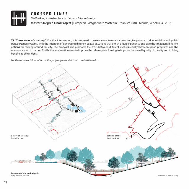
C R O S S E D L I N E SRe-thinking infrastructure in the search for urbanity
*To review the architecture projects, please visit the portfolio SELECTED WORK _ ARCHITECTURE
Master’s Degree Final Project | European Postgraduate Master in Urbanism EMU | Merida, Venezuela | 2015
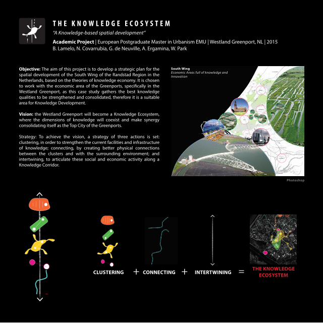
T H E K N O W L E D G E E C O S Y S T E M“A Knowledge-based spatial development”
Academic Project | European Postgraduate Master in Urbanism EMU | Westland Greenport, NL | 2015
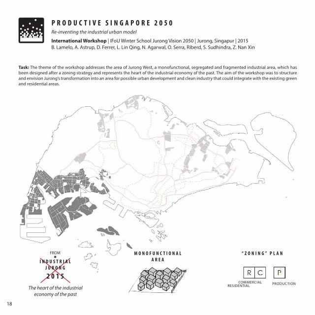
P R O D U C T I V E S I N G A P O R E 2 0 5 0Re-inventing the industrial urban model
International Workshop | IFoU Winter School Jurong Vision 2050 | Jurong, Singapur | 2015
T H E C I T Y A F T E R T H E M E D I T E R R A N E A N G A M E S Plan for Tarragona 2017
Academic Project | European Postgraduate Master in Urbanism EMU | Tarragona, Spain | 2014
P R O J E C T I N G T H E T E R R I T O R YHand by hand: From recognizing the differences to the construction of linking spaces
Academic Project | European Postgraduate Master in Urbanism EMU | Bages, Spain | 2013
H P AUrban design of the Public Space of the Oncology and Cardiology Hospital of Caracas
Professional Project | Caracas, Venezuela | 2012
9
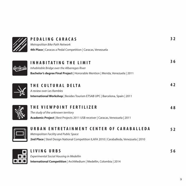
3 2
3 6
4 2
4 8
5 2
5 6L I V I N G U R B SExperimental Social Housing in Medellin
International Competition | ArchMedium | Medellin, Colombia | 2014
P E D A L I N G C A R A C A SMetropolitan Bike Path Network
4th Place | Caracas a Pedal Competition | Caracas, Venezuela
I N H A B I T A T I N G T H E L I M I TInhabitable Bridge over the Albarregas River
Bachelor’s degree Final Project | Honorable Mention | Merida, Venezuela | 2011
T H E C U L T U R A L D E L T AA review over Les Rambles
International Workshop | Besides Tourism ETSAB UPC | Barcelona, Spain | 2011
T H E V I E W P O I N T F E R T I L I Z E R The study of the unknown territory
Academic Project | Best Projects 2011 USB receiver | Caracas, Venezuela | 2011
U R B A N E N T R E T A I N M E N T C E N T E R O F C A R A B A L L E D A Metropolitan Facility and Public Space
2nd Place | Steel Design National Competition ILAFA 2010 | Caraballeda, Venezuela | 2010
10
C R O S S E D L I N E SRe-thinking infrastructure in the search for urbanity
Master’s Degree Final Project | European Postgraduate Master in Urbanism EMU | Merida, Venezuela | 2015
Objective: The aim of this thesis is to create a strategy for the urban regeneration and development of Merida, on the premise of rethinking the infrastructure space in the search of urbanity. It is an opportunity to structure the transformation of the city into a consolidated touristic and student town, as well it is an opportunity to propose a new paradigm for the contemporary city where the relationship between nature, city and infrastructure is rebuilt.
Strategy: A strategy of crossing the lines between infrastructure and nature is set, in order to tackle the problems of the city and at the same time, to create the conditions that promote urbanity. The strategy consists of three main actions: to increase the transversal connections; to redefine the longitudinal axes and to cross these lines, in order to generate new points of maximum interaction in the city.
Testing ground: To test the strategy, 3 interventions are proposed in an area chosen as case study, each responding to an action of the strategy. Besides being examples, these are strategic interventions and intend to be triggers of the transformation of the city.
Transversal axesPotential for urbanity found in the historical analysis
Case Study
Hand drawing + Photoshop
Hand drawing + Photoshop
11
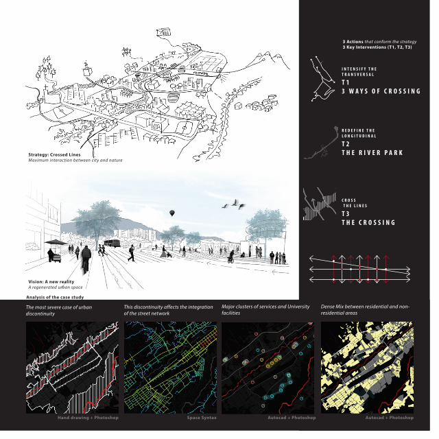
Vision: A new realityA regenerated urban space
Strategy: Crossed LinesMaximum interaction between city and nature
The most severe case of urban discontinuity
This discontinuity affects the integration of the street network
Analysis of the case study
T 2T H E R I V E R P A R K
R E D E F I N E T H E L O N G I T U D I N A L
C R O S S T H E L I N E S
I N T E N S I F Y T H E T R A N S V E R S A L
T 13 W A Y S O F C R O S S I N G
T 3T H E C R O S S I N G
3 Actions that conform the strategy3 Key Interventions (T1, T2, T3)
Hand drawing + Photoshop Autocad + Photoshop Autocad + PhotoshopSpace Syntax
Dense Mix between residential and non-residential areas
Major clusters of services and University facilities
12
C R O S S E D L I N E SRe-thinking infrastructure in the search for urbanity
Master’s Degree Final Project | European Postgraduate Master in Urbanism EMU | Merida, Venezuela | 2015
T1 “Three ways of crossing”: For this intervention, it is proposed to create more transversal axes to give priority to slow mobility and public transportation systems, with the intention of generating different spatial situations that enrich urban experience and give the inhabitant different options for moving around the city. The proposal also promotes the cross between different uses, especially between urban programs and the ones associated to nature. Finally, the intervention aims to improve the urban space, looking to improve the overall quality of the city and to bring benefits to all residents.
For the complete information on this project, please visit issuu.com/bettilamelo
3 ways of crossingIsometric view
Scheme of the Intervention
Recovery of a historical pathLongitudinal Section Autocad + Photoshop
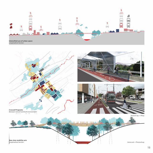
13
Crossed ProgramsBetween natural and built environment
Intensified use of urban spaceLongitudinal Section
New slow mobility axis Longitudinal Section Autocad + Photoshop
Sketch Up + VRay
14
CLUSTERING CONNECTING INTERTWINING++ = THE KNOWLEDGE ECOSYSTEM
T H E K N O W L E D G E E C O S Y S T E M“A Knowledge-based spatial development”
Academic Project | European Postgraduate Master in Urbanism EMU | Westland Greenport, NL | 2015B. Lamelo, N. Covarrubia, G. de Neuville, A. Ergamina, W. Park
South WingEconomic Areas full of knowledge and Innovation
Objective: The aim of this project is to develop a strategic plan for the spatial development of the South Wing of the Randstad Region in the Netherlands, based on the theories of knowledge economy. It is chosen to work with the economic area of the Greenports, specifically in the Westland Greenport, as this case study gathers the best knowledge qualities to be strengthened and consolidated, therefore it is a suitable area for Knowledge Development.
Vision: the Westland Greenport will become a Knowledge Ecosystem, where the dimensions of knowledge will coexist and make synergy consolidating itself as the Top City of the Greenports.
Strategy: To achieve the vision, a strategy of three actions is set: clustering, in order to strengthen the current facilities and infrastructure of knowledge; connecting, by creating better physical connections between the clusters and with the surrounding environment; and intertwining, to articulate these social and economic activity along a Knowledge Corridor.
Photoshop
15
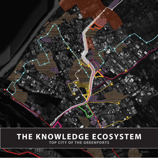
THE KNOWLEDGE ECOSYSTEMTOP CIT Y OF THE GREENPORTS
Illustrator
16
T H E K N O W L E D G E E C O S Y S T E M“A Knowledge-based spatial development”
Academic Project | European Postgraduate Master in Urbanism EMU | Westland Greenport, NL | 2015B. Lamelo, N. Covarrubia, G. de Neuville, A. Ergamina, W. Park
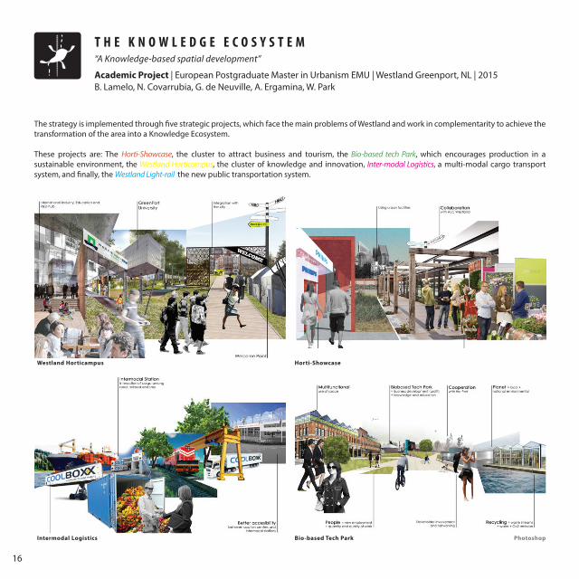
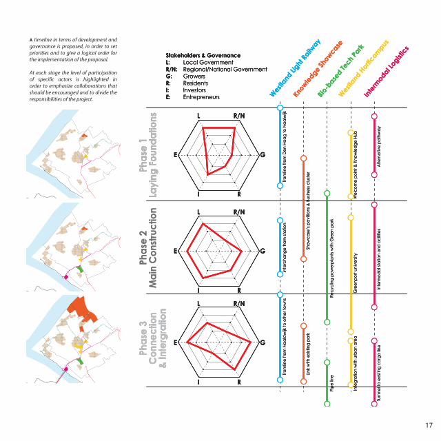
Intermodal Logistics
Westland Horticampus
Bio-based Tech Park
Horti-Showcase
Photoshop
The strategy is implemented through five strategic projects, which face the main problems of Westland and work in complementarity to achieve the transformation of the area into a Knowledge Ecosystem.
These projects are: The Horti-Showcase, the cluster to attract business and tourism, the Bio-based tech Park, which encourages production in a sustainable environment, the Westland Horticampus, the cluster of knowledge and innovation, Inter-modal Logistics, a multi-modal cargo transport system, and finally, the Westland Light-rail, the new public transportation system.
17
Wes
tland
Light
Railw
ay
Know
ledge
Show
case
Bio-
based Te
ch P
ark
Wes
tland
Hor
ticam
pus
Inte
rmod
al Log
istic
s
Pha
se 1
Layi
ng F
oun
da
tions
Pha
se 2
Ma
in C
ons
truc
tion
Pha
se 3
Co
nne
ctio
n&
Inte
rgra
tion
Stakeholders & GovernanceL: Local GovernmentR/N: Regional/National GovernmentG: GrowersR: ResidentsI: InvestorsE: Entrepreneurs
L R/N
G
RI
E
L R/N
G
RI
E
L R/N
G
RI
E
Tra
mlin
e fr
om
De
n H
aa
g to
Na
alw
ijk
We
lco
me
po
int &
Kno
wle
dg
e H
ubG
ree
npo
rt u
nive
rsity
Inte
gra
tion
with
urb
an
are
a
Alte
rna
tive
pa
thw
ay
Turn
nel t
o e
xist
ing
ca
rgo
line
Inte
rmo
da
l sta
tion
and
ac
ilitie
s
Sho
wc
ase
’s p
avi
llions
& B
usin
ess
clu
ste
rLi
nk w
ith e
xist
ing
pa
rk
Rec
yclin
g p
ow
erp
lant
s w
ith G
ree
n p
ark
Tra
mlin
e fr
om
Na
ald
wijk
to o
the
r to
wns
Pip
e li
ne
inte
rcha
nge
tra
m s
tatio
n
Wes
tland
Light
Railw
ay
Know
ledge
Show
case
Bio-
based Te
ch P
ark
Wes
tland
Hor
ticam
pus
Inte
rmod
al Log
istic
s
Pha
se 1
Layi
ng F
oun
da
tions
Pha
se 2
Ma
in C
ons
truc
tion
Pha
se 3
Co
nne
ctio
n&
Inte
rgra
tion
Stakeholders & GovernanceL: Local GovernmentR/N: Regional/National GovernmentG: GrowersR: ResidentsI: InvestorsE: Entrepreneurs
L R/N
G
RI
E
L R/N
G
RI
E
L R/N
G
RI
E
Tra
mlin
e fr
om
De
n H
aa
g to
Na
alw
ijk
We
lco
me
po
int &
Kno
wle
dg
e H
ubG
ree
npo
rt u
nive
rsity
Inte
gra
tion
with
urb
an
are
a
Alte
rna
tive
pa
thw
ay
Turn
nel t
o e
xist
ing
ca
rgo
line
Inte
rmo
da
l sta
tion
and
ac
ilitie
s
Sho
wc
ase
’s p
avi
llions
& B
usin
ess
clu
ste
rLi
nk w
ith e
xist
ing
pa
rk
Rec
yclin
g p
ow
erp
lant
s w
ith G
ree
n p
ark
Tra
mlin
e fr
om
Na
ald
wijk
to o
the
r to
wns
inte
rcha
nge
tra
m s
tatio
n
Pip
e li
ne
Wes
tland
Light
Railw
ay
Know
ledge
Show
case
Bio-
based Te
ch P
ark
Wes
tland
Hor
ticam
pus
Inte
rmod
al Log
istic
s
Pha
se 1
Layi
ng F
oun
da
tions
Pha
se 2
Ma
in C
ons
truc
tion
Pha
se 3
Co
nne
ctio
n&
Inte
rgra
tion
Stakeholders & GovernanceL: Local GovernmentR/N: Regional/National GovernmentG: GrowersR: ResidentsI: InvestorsE: Entrepreneurs
L R/N
G
RI
E
L R/N
G
RI
E
L R/N
G
RI
E
Tra
mlin
e fr
om
De
n H
aa
g to
Na
alw
ijk
We
lco
me
po
int &
Kno
wle
dg
e H
ubG
ree
npo
rt u
nive
rsity
Inte
gra
tion
with
urb
an
are
a
Alte
rna
tive
pa
thw
ay
Turn
nel t
o e
xist
ing
ca
rgo
line
Inte
rmo
da
l sta
tion
and
ac
ilitie
s
Sho
wc
ase
’s p
avi
llions
& B
usin
ess
clu
ste
rLi
nk w
ith e
xist
ing
pa
rk
Rec
yclin
g p
ow
erp
lant
s w
ith G
ree
n p
ark
Tra
mlin
e fr
om
Na
ald
wijk
to o
the
r to
wns
Pip
e li
ne
inte
rcha
nge
tra
m s
tatio
n
A timeline in terms of development and governance is proposed, in order to set priorities and to give a logical order for the implementation of the proposal.
At each stage the level of participation of specific actors is highlighted in order to emphasize collaborations that should be encouraged and to divide the responsibilities of the project.
18
M O N O F U N C T I O N A L A R E A
FROM
The heart of the industrial economy of the past
“ Z O N I N G ” P L A N
PRODUCTIONRESIDENTIALCOMMERCIAL
P R O D U C T I V E S I N G A P O R E 2 0 5 0Re-inventing the industrial urban model
International Workshop | IFoU Winter School Jurong Vision 2050 | Jurong, Singapur | 2015B. Lamelo, A. Astrup, D. Ferrer, L. Lin Qing, N. Agarwal, O. Serra, Riberd, S. Sudhindra, Z. Nan Xin
Task: The theme of the workshop addresses the area of Jurong West, a monofunctional, segregated and fragmented industrial area, which has been designed after a zoning strategy and represents the heart of the industrial economy of the past. The aim of the workshop was to structure and envision Jurong’s transformation into an area for possible urban development and clean industry that could integrate with the existing green and residential areas.
I N D U S T R I A LJ U R O N G
2 0 1 5
19
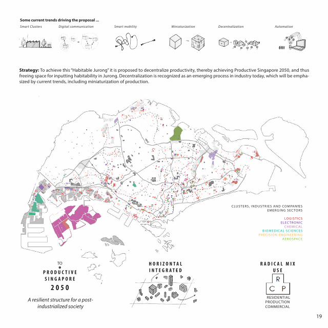
H O R I Z O N T A LI N T E G R A T E D
R A D I C A L M I X U S E
RESIDENTIALPRODUCTIONCOMMERCIAL
TO
P R O D U C T I V E S I N G A P O R E
2 0 5 0A resilient structure for a post-
industrialized society
Strategy: To achieve this “Habitable Jurong” it is proposed to decentralize productivity, thereby achieving Productive Singapore 2050, and thus freeing space for inputting habitability in Jurong. Decentralization is recognized as an emerging process in industry today, which will be empha-sized by current trends, including miniaturization of production.
C LU S T E R S , I N D U S T R I E S A N D CO M PA N I E S E M E R G I N G S E C TO R S
LO G I S T I C S E L E C T R O N I C
C H E M I C A LB I O M E D I C A L S C I E N C E S
P R E C I S I O N E N G I N E E R I N GA E R O S PAC E
Some current trends driving the proposal ...Smart Clusters Digital communication Smart mobility Miniaturization Decentralization Automation
20
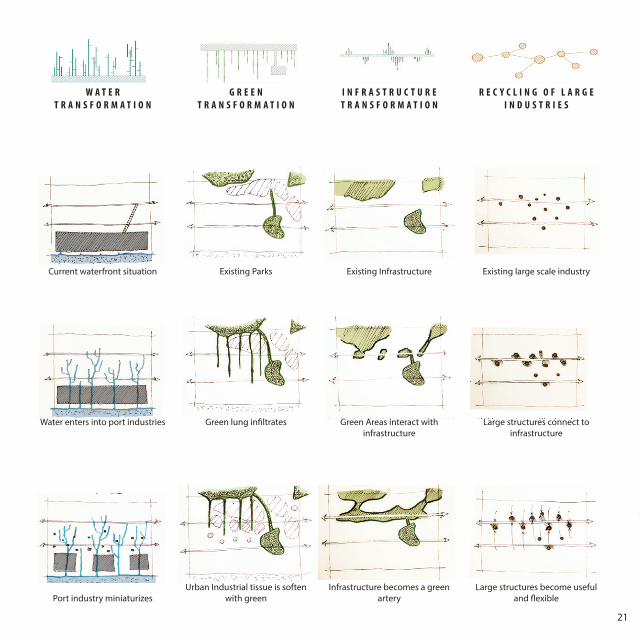
P R O D U C T I V E S I N G A P O R E 2 0 5 0Re-inventing the industrial urban model
International Workshop | IFoU Winter School Jurong Vision 2050 | Jurong, Singapur | 2015B. Lamelo, A. Astrup, D. Ferrer, L. Lin Qing, N. Agarwal, O. Serra, Riberd, S. Sudhindra, Z. Nan Xin
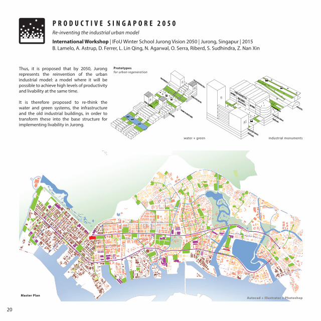
Master Plan
Thus, it is proposed that by 2050, Jurong represents the reinvention of the urban industrial model: a model where it will be possible to achieve high levels of productivity and livability at the same time.
It is therefore proposed to re-think the water and green systems, the infrastructure and the old industrial buildings, in order to transform these into the base structure for implementing livability in Jurong.
Prototypesfor urban regeneration
water + green industrial monuments
Autocad + Illustrator + Photoshop
21
W A T E R T R A N S F O R M A T I O N
G R E E NT R A N S F O R M A T I O N
I N F R A S T R U C T U R ET R A N S F O R M A T I O N
R E C Y C L I N G O F L A R G E I N D U S T R I E S
Water enters into port industries Green lung infiltrates Green Areas interact with infrastructure
Large structures connect to infrastructure
Port industry miniaturizesUrban Industrial tissue is soften
with greenInfrastructure becomes a green
arteryLarge structures become useful
and flexible
Current waterfront situation Existing Parks Existing Infrastructure Existing large scale industry
22
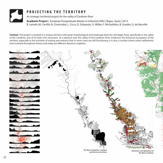
P R O J E C T I N G T H E T E R R I T O R YAn strategic territorial project for the valley of Cardener River
Academic Project | European Postgraduate Master in Urbanism EMU | Bages, Spain | 2013B. Lamelo, M. Carrillo, N. Covarrubia, L. Ciccu, D. Zelayarán, G. Millán, F. Michailidou, B. Guedes, G. de Neuville
The Baix Cardener, a unique and diverse territory
Activities and dynamics of the Baix Cardener
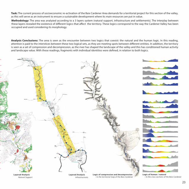
Layered AnalysisNatural Support
Context: The project is located in a unique territory with great morphological and landscape diversity, the Bages Area; specifically in the valley of the Cardener, one of its main river structures. As a physical unit, the valley of the Cardener River evidences the historical occupation of the territory, especially in the activities of mining and industry that in some cases are still functioning. It is also a corridor where urban settlements have evolved throughout history and today set different dynamics together.
23
Layered AnalysisInfrastructures
Methodology: The area was analyzed according to a 3 layers system (natural support, infrastructure and settlements). The interplay between these layers revealed the existence of different logics that affect the territory. These logics correspond to the way the Cardener Valley has been occupied and used considering its morphology.
Task: The current process of socioeconomic re-activation of the Baix Cardener Area demands for a territorial project for this section of the valley, as this will serve as an instrument to ensure a sustainable development where its main resources are put in value.
Logic of compression and decompression - In the territorial map of the Baix Cardener
Layered AnalysisNatural Support
Logic of human / natural - In the cross sections of the Baix Cardener
Analysis Conclusions: The area is seen as the encounter between two logics that coexist: the natural and the human logic. In this reading, attention is paid to the interstices between these two logical sets, as they are meeting spots between different entities. In addition, the territory is seen as a set of compression and decompression, as the river has shaped the landscape of the valley and this has conditioned human activity and landscape value. With these readings, fragments with individual identities were defined, in relation to both logics.
24
1
2
3
4
5
B. Lamelo, M. Carrillo, N. Covarrubia, L. Ciccu, D. Zelayarán, G. Millán, F. Michailidou, B. Guedes, G. de Neuville
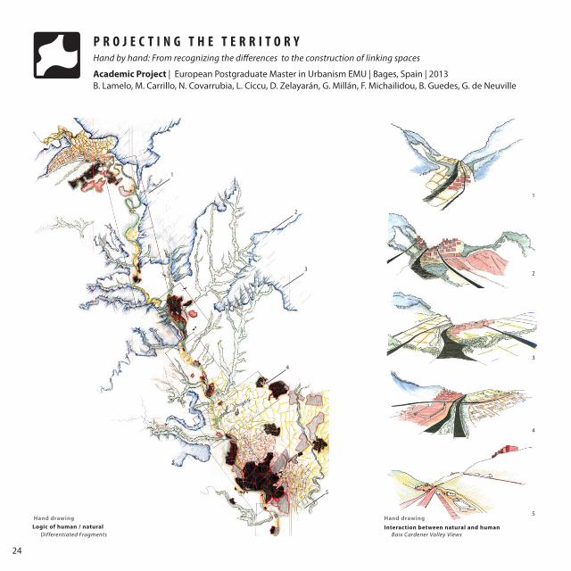
Logic of human / natural Interaction between natural and human Baix Cardener Valley ViewsDifferentiated Fragments
P R O J E C T I N G T H E T E R R I T O R YHand by hand: From recognizing the differences to the construction of linking spaces
Academic Project | European Postgraduate Master in Urbanism EMU | Bages, Spain | 2013
Hand drawing Hand drawing
5
4
3
2
1
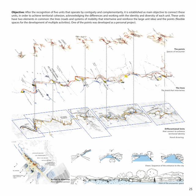
25
Differentiated Unitsthat connect to enhance
territorial identity
The linesThe braid that intertwines
The pointsSpaces of encounter
Objective: After the recognition of five units that operate by contiguity and complementarity, it is established as main objective to connect these units, in order to achieve territorial cohesion, acknowledging the differences and working with the identity and diversity of each unit. These units have two elements in common: the lines (roads and systems of mobility that intertwine and reinforce the large unit idea) and the points (flexible spaces for the development of multiple activities). One of the points was developed as a personal project.
Hand drawing
Arrival to diversityPoint of Intervention
Views: Sequence of the entrance to the city
View of the encounter space
26
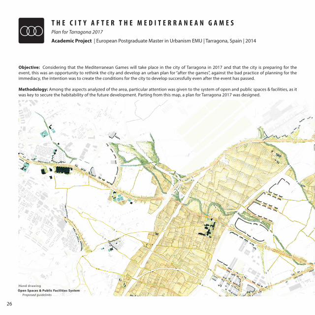
T H E C I T Y A F T E R T H E M E D I T E R R A N E A N G A M E S Plan for Tarragona 2017
Academic Project | European Postgraduate Master in Urbanism EMU | Tarragona, Spain | 2014
Objective: Considering that the Mediterranean Games will take place in the city of Tarragona in 2017 and that the city is preparing for the event, this was an opportunity to rethink the city and develop an urban plan for “after the games”, against the bad practice of planning for the immediacy, the intention was to create the conditions for the city to develop successfully even after the event has passed.
Methodology: Among the aspects analyzed of the area, particular attention was given to the system of open and public spaces & facilities, as it was key to secure the habitability of the future development. Parting from this map, a plan for Tarragona 2017 was designed.
Open Spaces & Public Facilities SystemProposed guidelines
Hand drawing
27
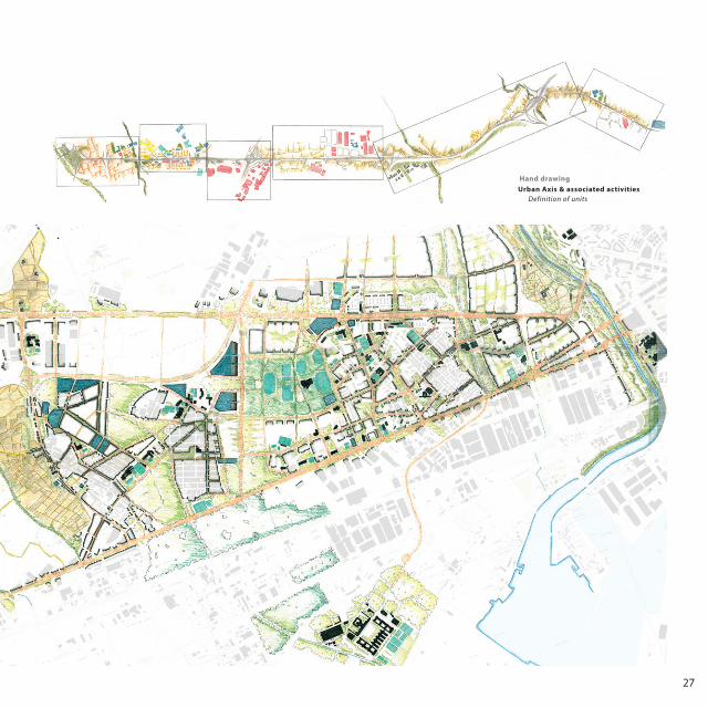
Urban Axis & associated activities Definition of units
Hand drawing
28
T H E C I T Y A F T E R T H E M E D I T E R R A N E A N G A M E S Plan for Tarragona 2017
Academic Project | European Postgraduate Master in Urbanism EMU | Tarragona, Spain | 2014
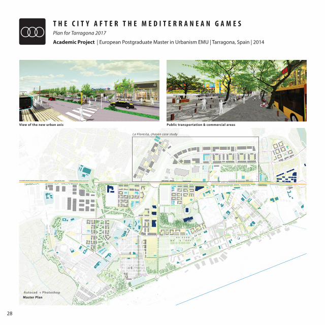
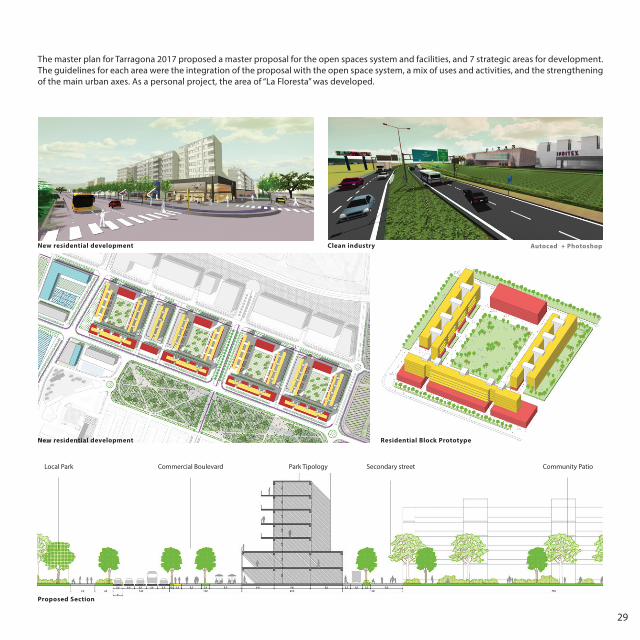
Master Plan
View of the new urban axis Public transportation & commercial areas
La Floresta, chosen case study
Autocad + Photoshop
29
The master plan for Tarragona 2017 proposed a master proposal for the open spaces system and facilities, and 7 strategic areas for development. The guidelines for each area were the integration of the proposal with the open space system, a mix of uses and activities, and the strengthening of the main urban axes. As a personal project, the area of “La Floresta” was developed.
Park TipologyLocal Park Commercial Boulevard Secondary street Community Patio
New residential development
New residential development
Proposed Section
Residential Block Prototype
Clean industry Autocad + Photoshop
30
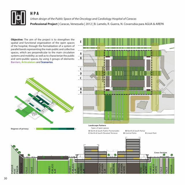
H P AUrban design of the Public Space of the Oncology and Cardiology Hospital of Caracas
Professional Project | Caracas, Venezuela | 2012 | B. Lamelo, R. Guerra, N. Covarrubia para AGUA & AREPA
Objective: The aim of the project is to strengthen the spatial and functional organization of the open spaces of the hospital, through the formalization of a system of parallel bands representing the main public and collective spaces, which are perpendicular to the main circulation systems and mobility; as well as to characterize the public and semi-puiblic spaces, by using 3 groups of elements: Barriers, Articulators and Scenarios.
Cross Section
A North & South Public Promenades B North & South Patios C North & South Elevated Terraces D Central Patio E Lineal Park
Degrees of privacy - +
E
AB
CDC
BA
Landscape PatternTypes of open spaces
31
A view from the exterior
Source: AREPA
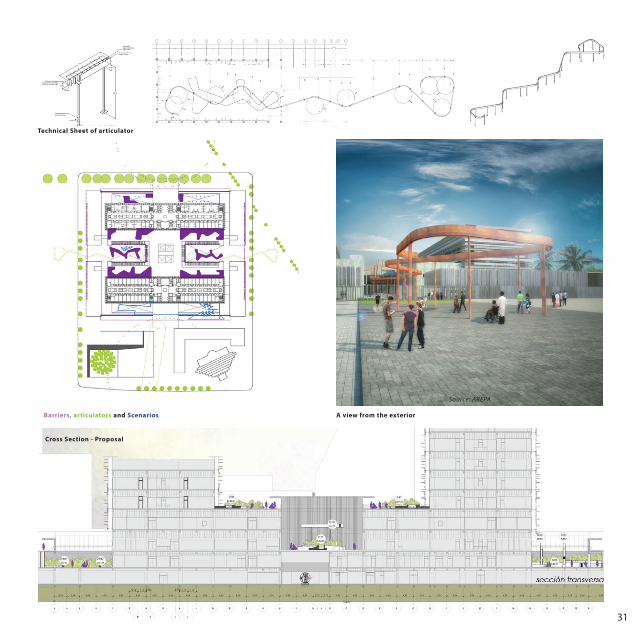
Barriers, articulators and Scenarios
Technical Sheet of articulator
Cross Section - Proposal
32
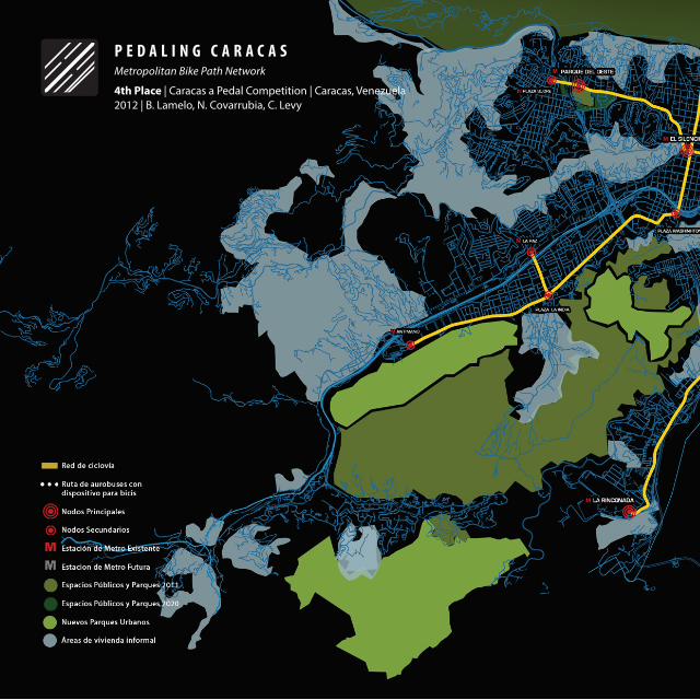
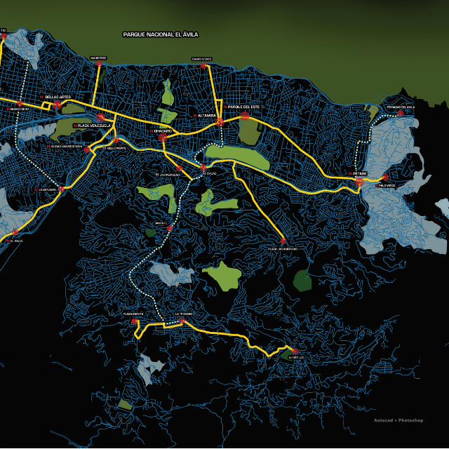
P E D A L I N G C A R A C A SMetropolitan Bike Path Network
4th Place | Caracas a Pedal Competition | Caracas, Venezuela 2012 | B. Lamelo, N. Covarrubia, C. Levy
33
Autocad + Photoshop
34
2012 | B. Lamelo, N. Covarrubia, C. Levy
Objective: The aim of the proposal is to promote urban cycling as a possible solution for the problems of mobility of Caracas through the implementation of a bikepath network and its associated services. It is a proposal that focuses on the progressive change of infrastructure and civic culture. In each phase of the project it is intended to have enough strength to change mindsets and make urban cycling a new reality for citizens.
Methodology: To establish the main routes, the main points that generate urban dynamics were studied, and in that way, the bike path network is based on real flows and is adjusted to the current needs of the population. Nodes were also established, and were categorized in major and minor nodes, in order to determine the function of each. The nodes were also used to provide the city of urban infrastructure.
Phases: In terms of short- and medium-term feasibility of the project, it is intended that the first stage of formalizing the network involves minimal impact on existing roads. This involves initiatives such as the redeployment of wide roads, the use of separation elements, the improvement or creation of pavements, the treatment of intersections, among others.
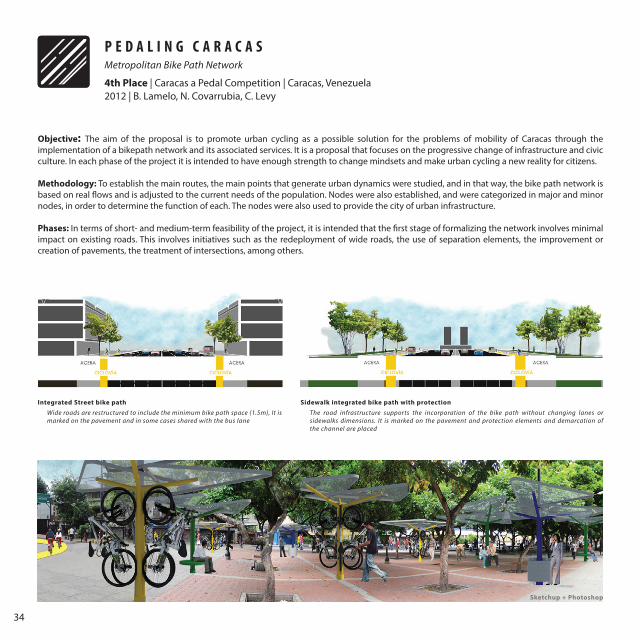
Integrated Street bike path Sidewalk integrated bike path with protection
Wide roads are restructured to include the minimum bike path space (1.5m), It is marked on the pavement and in some cases shared with the bus lane
The road infrastructure supports the incorporation of the bike path without changing lanes or sidewalks dimensions. It is marked on the pavement and protection elements and demarcation of the channel are placed
P E D A L I N G C A R A C A SMetropolitan Bike Path Network
4th Place | Caracas a Pedal Competition | Caracas, Venezuela
Sketchup + Photoshop
35
Independent bike path
Prototype No. 03Prototype No. 01-02 Prototype No. 04
Sidewalk integrated bike path - unprotected
The bike path is included in residual spaces of existing roads. Dimensions of lanes or sidewalks are not altered.
Bike parking ModuleSeating Module
Trash can and drinking fountain Module
Bike rack devices in public transportation
The bike path is incorporated into the sidewalk and is normally related to an urban park or linear public space
36
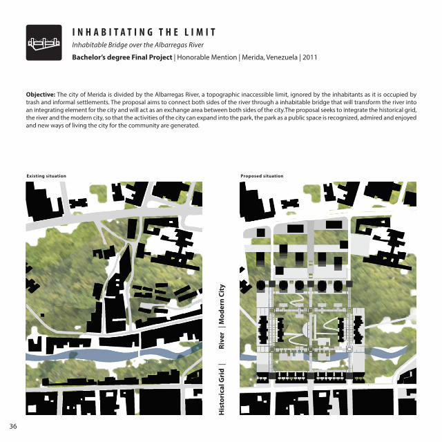
I N H A B I T A T I N G T H E L I M I TInhabitable Bridge over the Albarregas River
Bachelor’s degree Final Project | Honorable Mention | Merida, Venezuela | 2011
His
tori
cal G
rid
|
Rive
r |
Mod
ern
City
Objective: The city of Merida is divided by the Albarregas River, a topographic inaccessible limit, ignored by the inhabitants as it is occupied by trash and informal settlements. The proposal aims to connect both sides of the river through a inhabitable bridge that will transform the river into an integrating element for the city and will act as an exchange area between both sides of the city.The proposal seeks to integrate the historical grid, the river and the modern city, so that the activities of the city can expand into the park, the park as a public space is recognized, admired and enjoyed and new ways of living the city for the community are generated.
Existing situation Proposed situation
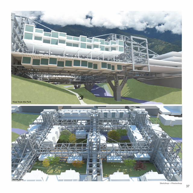
37
View from the Park
Aerial view
Sketchup + Photoshop
38
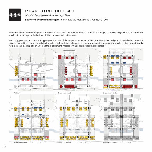
In order to avoid a zoning configuration in the use of space and to ensure maximum occupancy of the bridge, a normative on gradual occupation is set, which determines a gradual mix of uses, in the horizontal and vertical sense.
In existing, proposed and recovered typologies, the spirit of the proposal can be appreciated: the inhabitable bridge must provide the connection between both sides of the river, and also it should enable activities to happens in its own structure. It is a square and a gallery, it is a viewpoint and a residence, and it is the platform where all the local elements meet and mingle to produce rich experiences.
Park Level
Residential Level 1
Street Level - South
Residential Level 2
Street Level - North
Roof Plan
I N H A B I T A T I N G T H E L I M I TInhabitable Bridge over the Albarregas River
Bachelor’s degree Final Project | Honorable Mention | Merida, Venezuela | 2011
39
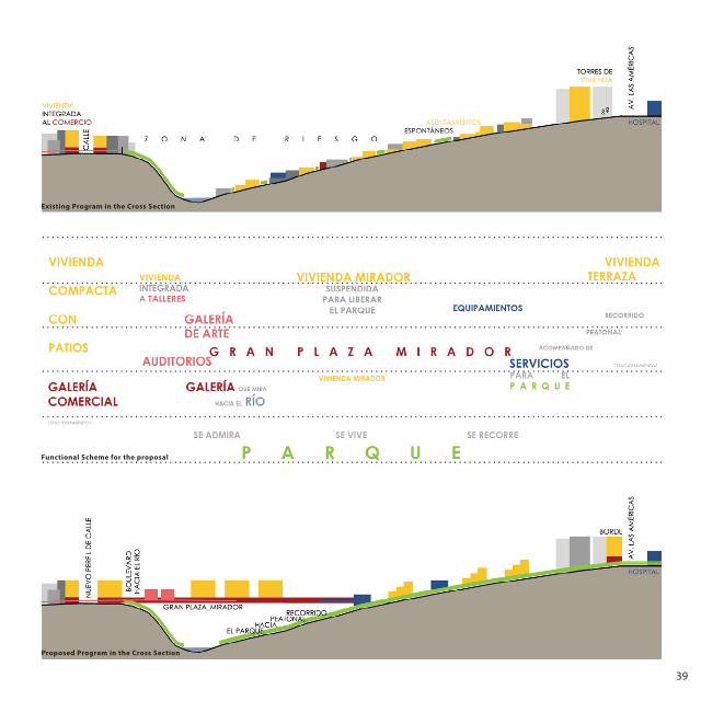
Functional Scheme for the proposal
Existing Program in the Cross Section
Proposed Program in the Cross Section
40
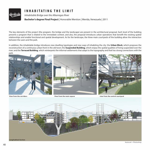
The key elements of the project (the program, the bridge and the landscape) are present in the architectural proposal. Each level of the building presents a program that is related to the immediate context, and also, the proposal introduces urban operations that benefit the existing spatial relationships and enable functional and spatial development. As for the landscape, the three main courtyards of the building allow the interaction between the users and the park.
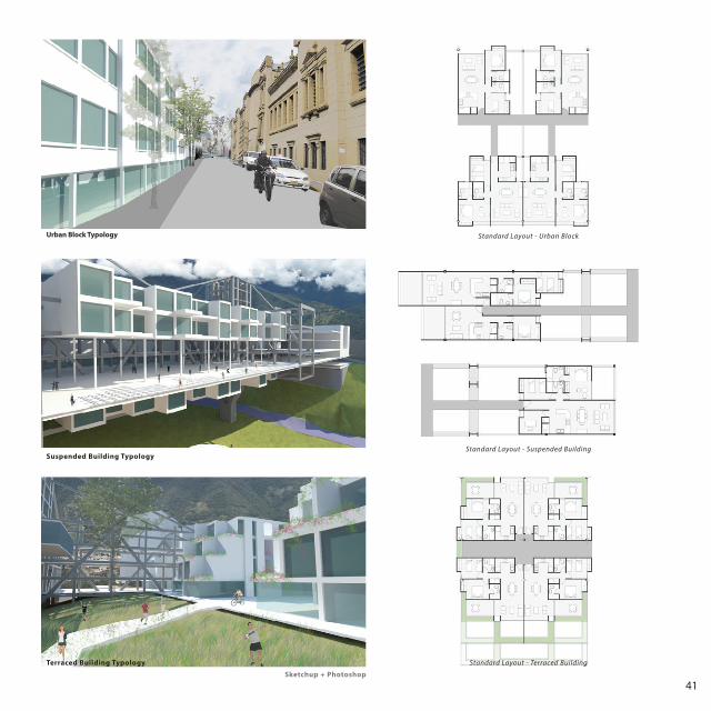
In addition, the inhabitable bridge introduces new dwelling typologies and new ways of inhabiting the city: the Urban Block, which proposes the reconstruction of a continuous urban front in the old town; the Suspended Building, which enjoys the spatial qualities of living suspended over the river; and the Terraced Building, which reinterprets the informal settlements that adapt to the topography and that has strong connections with the park.
View from the corridors
Longitudinal Section
View from the main square view from the central courtyard
I N H A B I T A T I N G T H E L I M I TInhabitable Bridge over the Albarregas River
Bachelor’s degree Final Project | Honorable Mention | Merida, Venezuela | 2011
Autocad + Photoshop
41
Urban Block Typology
Suspended Building Typology
Terraced Building Typology
Standard Layout - Urban Block
Standard Layout - Suspended Building
Standard Layout - Terraced Building
Sketchup + Photoshop
42
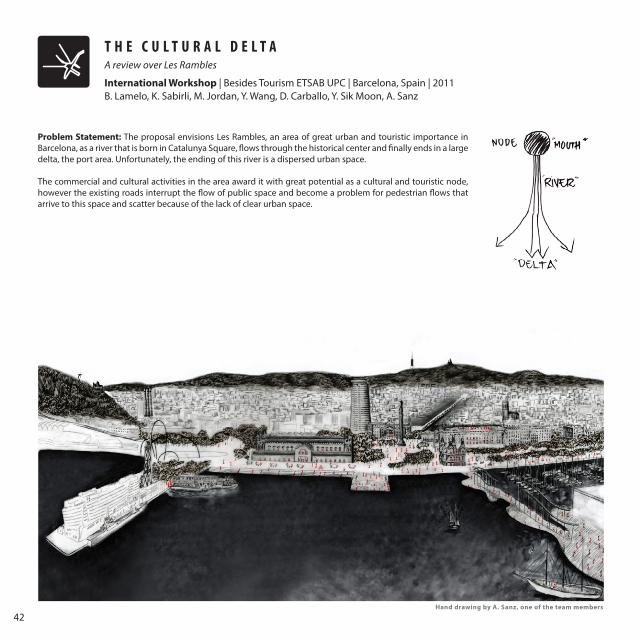
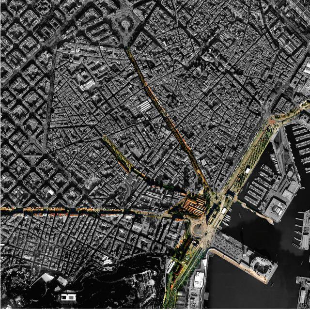
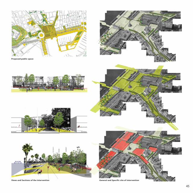
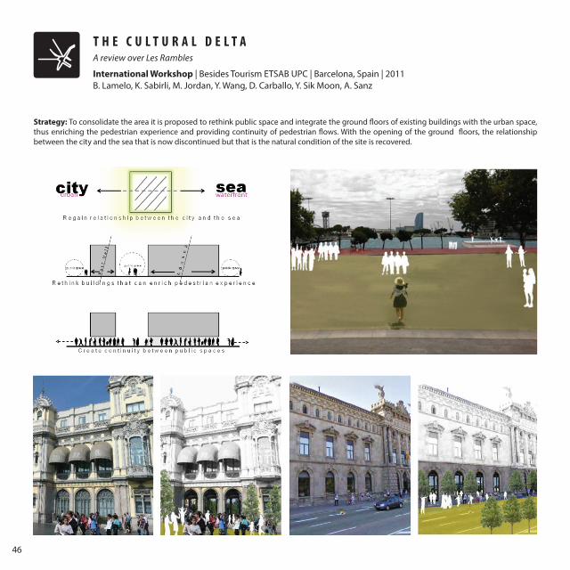
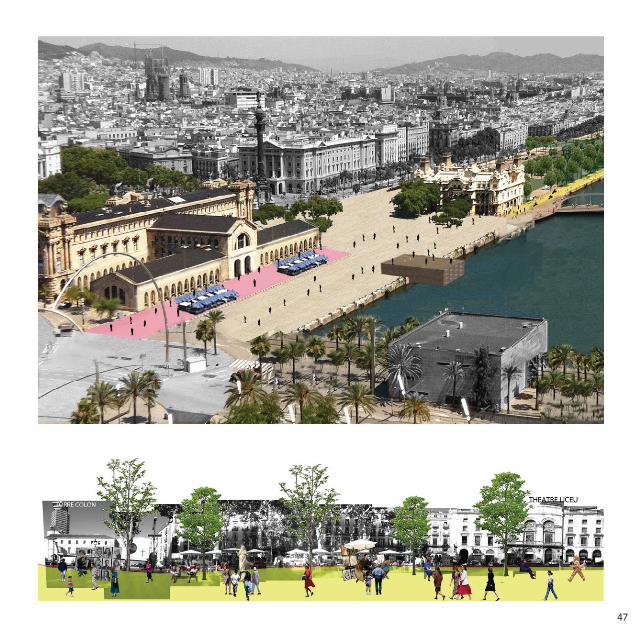
T H E C U L T U R A L D E L T AA review over Les Rambles
International Workshop | Besides Tourism ETSAB UPC | Barcelona, Spain | 2011 B. Lamelo, K. Sabirli, M. Jordan, Y. Wang, D. Carballo, Y. Sik Moon, A. Sanz
Problem Statement: The proposal envisions Les Rambles, an area of great urban and touristic importance in Barcelona, as a river that is born in Catalunya Square, flows through the historical center and finally ends in a large delta, the port area. Unfortunately, the ending of this river is a dispersed urban space.
The commercial and cultural activities in the area award it with great potential as a cultural and touristic node, however the existing roads interrupt the flow of public space and become a problem for pedestrian flows that arrive to this space and scatter because of the lack of clear urban space.
Hand drawing by A. Sanz, one of the team members
43
44
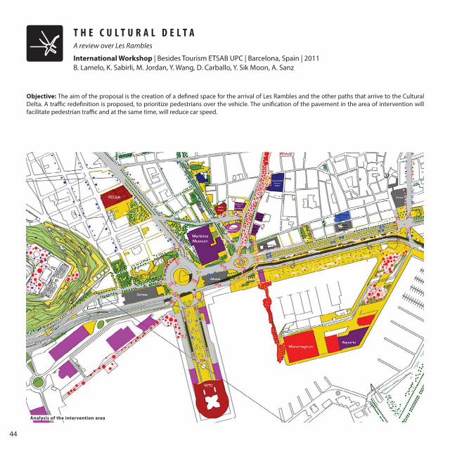
T H E C U L T U R A L D E L T A
B. Lamelo, K. Sabirli, M. Jordan, Y. Wang, D. Carballo, Y. Sik Moon, A. Sanz
Objective: The aim of the proposal is the creation of a defined space for the arrival of Les Rambles and the other paths that arrive to the Cultural Delta. A traffic redefinition is proposed, to prioritize pedestrians over the vehicle. The unification of the pavement in the area of intervention will facilitate pedestrian traffic and at the same time, will reduce car speed.
Analysis of the intervention area
A review over Les Rambles
International Workshop | Besides Tourism ETSAB UPC | Barcelona, Spain | 2011
45
Proposed public space
General and Specific site of interventionViews and Sections of the intervention
46
T H E C U L T U R A L D E L T A
B. Lamelo, K. Sabirli, M. Jordan, Y. Wang, D. Carballo, Y. Sik Moon, A. Sanz
Strategy: To consolidate the area it is proposed to rethink public space and integrate the ground floors of existing buildings with the urban space, thus enriching the pedestrian experience and providing continuity of pedestrian flows. With the opening of the ground floors, the relationship between the city and the sea that is now discontinued but that is the natural condition of the site is recovered.
A review over Les Rambles
International Workshop | Besides Tourism ETSAB UPC | Barcelona, Spain | 2011
47
48
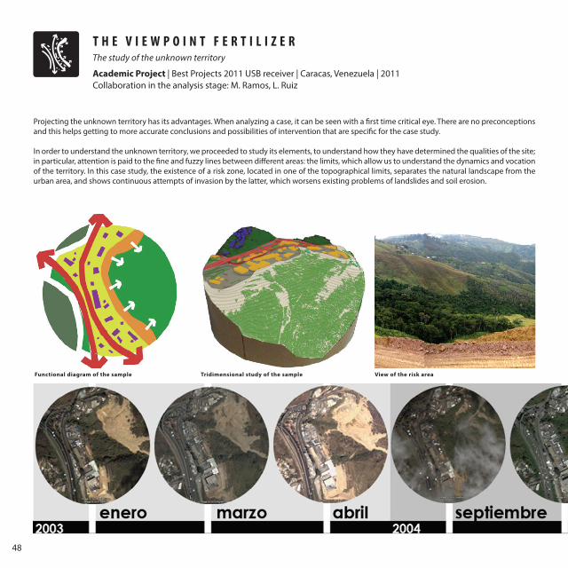
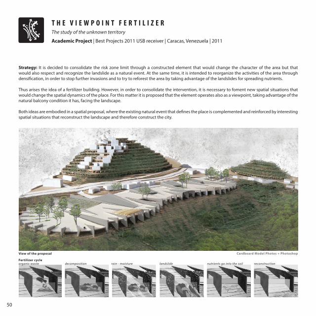
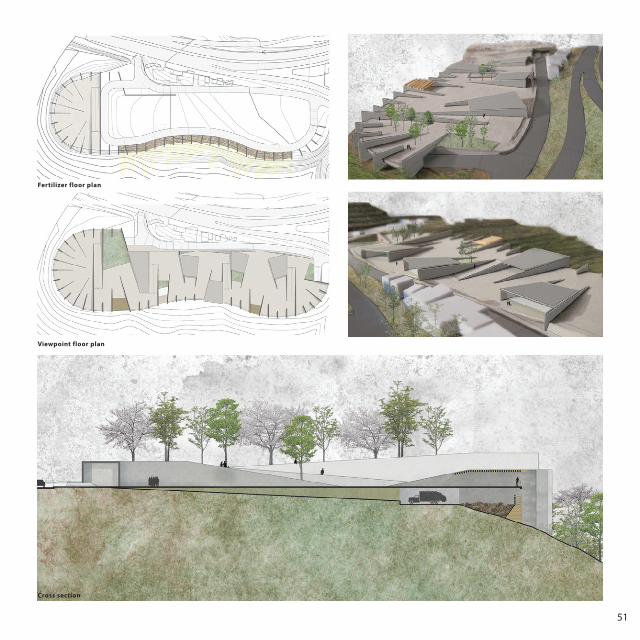
T H E V I E W P O I N T F E R T I L I Z E R The study of the unknown territory
Academic Project | Best Projects 2011 USB receiver | Caracas, Venezuela | 2011 Collaboration in the analysis stage: M. Ramos, L. Ruiz
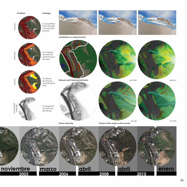
Projecting the unknown territory has its advantages. When analyzing a case, it can be seen with a first time critical eye. There are no preconceptions and this helps getting to more accurate conclusions and possibilities of intervention that are specific for the case study.
In order to understand the unknown territory, we proceeded to study its elements, to understand how they have determined the qualities of the site; in particular, attention is paid to the fine and fuzzy lines between different areas: the limits, which allow us to understand the dynamics and vocation of the territory. In this case study, the existence of a risk zone, located in one of the topographical limits, separates the natural landscape from the urban area, and shows continuous attempts of invasion by the latter, which worsens existing problems of landslides and soil erosion.
Functional diagram of the sample Tridimensional study of the sample View of the risk area
49
Landslide as a natural event
Natural and Constructed limits
Flows intensity Action of the water in the terrain
Problem Strategy
To consolidate limits through a constructed element
jan-mar
jul-sep oct-dec
apr-jun
To recognize the event by intervening on the area
To reforest the area by nourishing the land
To reorganize activities by densifying
Inva
sion
Risk
zon
eer
osio
nno
n gr
adua
l in
tens
ity
50
Strategy: It is decided to consolidate the risk zone limit through a constructed element that would change the character of the area but that would also respect and recognize the landslide as a natural event. At the same time, it is intended to reorganize the activities of the area through densification, in order to stop further invasions and to try to reforest the area by taking advantage of the landslides for spreading nutrients.
Thus arises the idea of a fertilizer building. However, in order to consolidate the intervention, it is necessary to foment new spatial situations that would change the spatial dynamics of the place. For this matter it is proposed that the element operates also as a viewpoint, taking advantage of the natural balcony condition it has, facing the landscape.
Both ideas are embodied in a spatial proposal, where the existing natural event that defines the place is complemented and reinforced by interesting spatial situations that reconstruct the landscape and therefore construct the city.
organic waste decomposition rain - moisture landslide nutrients go into the soil reconstruction
View of the proposal
Fertilizer cycle
T H E V I E W P O I N T F E R T I L I Z E R The study of the unknown territory
Academic Project | Best Projects 2011 USB receiver | Caracas, Venezuela | 2011
Cardboard Model Photos + Photoshop
51
Fertilizer floor plan
Viewpoint floor plan
Cross section
52
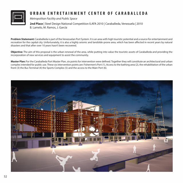
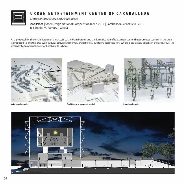
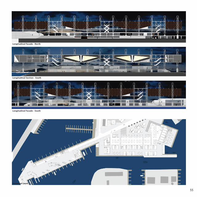
U R B A N E N T R E T A I N M E N T C E N T E R O F C A R A B A L L E D A Metropolitan Facility and Public Space
2nd Place | Steel Design National Competition ILAFA 2010 | Caraballeda, Venezuela | 2010 B. Lamelo, M. Ramos, J. García
Problem Statement: Caraballeda is part of the Venezuelan Port System. It is an area with high touristic potential and a source for entertainment and recreation for the capital city. Unfortunately, it is also a highly seismic and landslide-prone area, which has been affected in recent years by natural disasters and that after over 10 years hasn’t been recovered.
Objective: The aim of this proposal is the urban renewal of the area, while putting into value the touristic assets of Caraballeda and providing the incorporation of new services and equipment to assist the community.
Master Plan: For the Caraballeda Port Master Plan, six points for intervention were defined. Together they will constitute an architectural and urban complex intended for public use. These six intervention points are: Fishermen’s Port (1), Access to the bathing area (2), the rehabilitation of the urban front (3) the Bus Terminal (4) the Sports Complex (5) and the access to the Main Port (6).
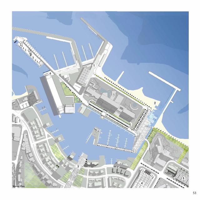
53
Master Plan
54
As a proposal for the rehabilitation of the access to the Main Port (6) and the formalization of it as a new center that promotes tourism in the area, it is proposed to link the area with cultural activities (cinemas, art galleries , outdoor amphitheaters) which is practically absent in the area. Thus, the Urban Entertainment Center of Caraballeda is born.
B. Lamelo, M. Ramos, J. García
Cross section
Urban scale model Architectural proposal model Structural model
U R B A N E N T R E T A I N M E N T C E N T E R O F C A R A B A L L E D A Metropolitan Facility and Public Space
2nd Place | Steel Design National Competition ILAFA 2010 | Caraballeda, Venezuela | 2010
55
Basement Level
Longitudinal Facade - South
Longitudinal Facade - North
Longitudinal Section - South
56
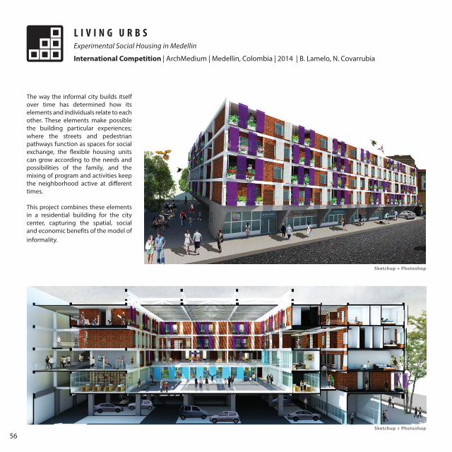
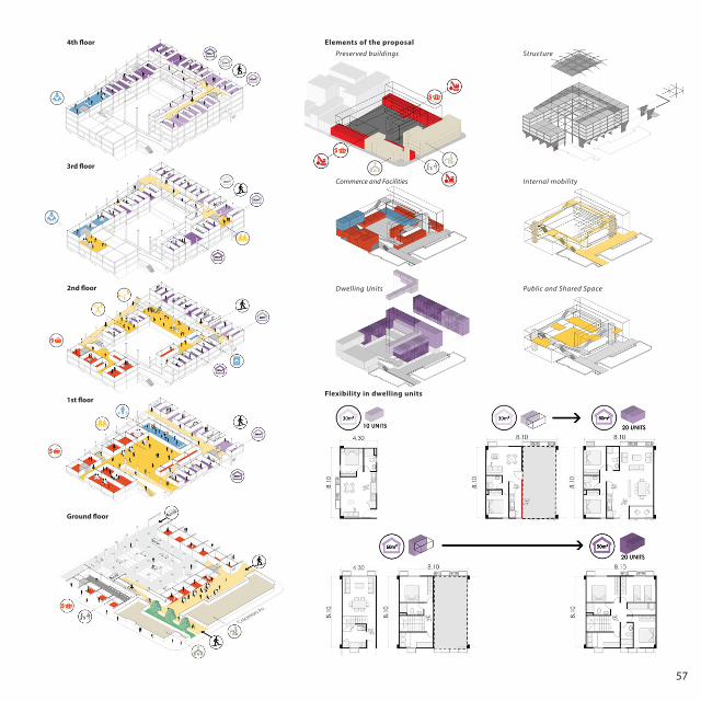
The way the informal city builds itself over time has determined how its elements and individuals relate to each other. These elements make possible the building particular experiences; where the streets and pedestrian pathways function as spaces for social exchange, the flexible housing units can grow according to the needs and possibilities of the family, and the mixing of program and activities keep the neighborhood active at different times.
This project combines these elements in a residential building for the city center, capturing the spatial, social and economic benefits of the model of informality.
L I V I N G U R B SExperimental Social Housing in Medellin
International Competition | ArchMedium | Medellin, Colombia | 2014 | B. Lamelo, N. Covarrubia
Sketchup + Photoshop
Sketchup + Photoshop
57
Preserved buildings
Commerce and Facilities
Structure
Internal mobility
Dwelling Units Public and Shared Space
3rd floor
Colombia Av.
Ground floor
1st floor
4th floor
2nd floor
Flexibility in dwelling units
Elements of the proposal
58
2 0 1 5
A R C H _ U R B
Cover Photo: Mayor Square, Ourense - 2012 [email protected]+34 617 69 11 35
B E T T I S A B E L L A M E L O


![The Future of Sustainable Urbanism: Society-Based ... · landscape urbanism in which landscape supplants architecture as the basis of urban design, and Newman et al. [25], elaborating](https://img.pdfslide.us/doc/110x75/5e5f64b060b26c51ec27f282/the-future-of-sustainable-urbanism-society-based-landscape-urbanism-in-which.jpg)