Embed Size (px)
Citation preview
MSc / MArch Landscape Urbanism 2019-2020
Programme Handbook and Course specifications 1
LANDSCAPE URBANISM ARCHITECTURAL ASSOCIATION
MSc / MArch in Landscape Urbanism 2018-19 PROGRAMME COURSE GUIDE
MSc / MArch Landscape Urbanism 2019-2020
Programme Handbook and Course specifications 2
1 INTRODUCTION & OVERWIEW ................................................................ 4
1.1 FIELDS OF RESEARCH ............................................................................ 5
1.2 BIFURCATION MODEL ........................................................................... 5
2 TEACHING STAFF LIST AND BIOS ........................................................... 7
3 PROGRAMME SPECIFICATION ................................................................. 9
3.1 EDUCATIONAL AIMS ............................................................................... 9
3.2 PROGRAMME OUTCOMES ................................................................... 11 3.2.1 LEARNING OBJECTIVES ...........................................................................11 3.2.2 SKILLS ACQUIRED DURING THE COURSE ......................................12 A- KNOWLEDGE AND UNDERSTANDING ...............................................12 B- INTELLECTUAL SKILLS .................................................................................13 C- RESEARCH SKILLS ...........................................................................................13 D- KEY TRANSFERABLE SKILLS .....................................................................14
3.3 CURRICULUM MAP ................................................................................ 14
3.4 PROGRAMME STRUCTURE ................................................................. 16 3.4.1 COURSE CREDITS AND ASSESSED WORK .......................................16
4 COURSE SPECIFICATIONS & ACADEMIC CALENDAR ....................... 17
4.1 PERMANENT AND VARIABLE CONTENT OF THE COURSE ..... 17
4.2 ACADEMIC CALENDAR ........................................................................ 18
4.3 PHASE 1 (ACTIVITIES): .......................................................................... 20
4.4 PHASE 2 (ACTIVITIES): ......................................................................... 20
4.5 DESIGN STUDIO ..................................................................................... 21 4.5.1 COURSE BRIEF ..............................................................................................21 4.5.2 LEARNING OUTCOMES ............................................................................22 4.5.3 ASSESSED WORK ..........................................................................................22 4.5.4 ASSESSMENT CRITERIA ............................................................................23 4.5.5 DESIGN STUDIO OUTLINE DESCRIPTION PER TERM ..............23 4.5.6 DESIGN STUDIO WORKSHOPS ..............................................................24 4.5.7 FIELD TRIP ......................................................................................................24 4.5.8 DESIGN STUDIO BIBLIOGRAPHY ........................................................24
4.6 LANDSCAPE URBANISM: MODELS METHODS AND CONCEPTS SEMINAR ERROR! BOOKMARK NOT DEFINED.
4.6.1 LEARNING OUTCOMES ...................... ERROR! BOOKMARK NOT DEFINED.
4.6.2 ASSESSED WORK ............ ERROR! BOOKMARK NOT DEFINED.
MSc / MArch Landscape Urbanism 2019-2020
Programme Handbook and Course specifications 3
4.6.3 ASSESSMENT CRITERIA ...................... ERROR! BOOKMARK NOT DEFINED.
4.6.4 TERM OUTLINE DESCRIPTION ....... ERROR! BOOKMARK NOT DEFINED.
4.7 HISTORY AND THEORY SEMINAR & LECTURE SERIES ............ 25 4.7.1 LEARNING OUTCOMES ...................... ERROR! BOOKMARK NOT
DEFINED. 4.7.2 ASSESSED WORK ............ ERROR! BOOKMARK NOT DEFINED. 4.7.3 ASSESSMENT CRITERIA ...................... ERROR! BOOKMARK NOT
DEFINED. 4.7.4 TERM 1: MODELS METHODS AND HISTORIES ............... ERROR!
BOOKMARK NOT DEFINED. 4.7.5 TERM 2: THE RHETORIC OF MAPPING .. ERROR! BOOKMARK
NOT DEFINED.
4.8 WORKSHOP SERIES: MACHINING LANDSCAPES ................ ERROR! BOOKMARK NOT DEFINED.
4.8.1 LEARNING OUTCOMES ...................... ERROR! BOOKMARK NOT DEFINED.
4.8.2 ASSESSED WORK ............ ERROR! BOOKMARK NOT DEFINED. 4.8.3 ASSESSMENT CRITERIA ...................... ERROR! BOOKMARK NOT
DEFINED. 4.8.4 TERM OUTLINE DESCRIPTION ....... ERROR! BOOKMARK NOT
DEFINED. 4.8.5 COURSE BIBLIOGRAPHY .................... ERROR! BOOKMARK NOT
DEFINED.
4.9 LECTURE SERIES: LANDFORMS DYNAMICS ERROR! BOOKMARK NOT DEFINED.
4.9.1 LEARNING OUTCOMES ...................... ERROR! BOOKMARK NOT DEFINED.
4.9.2 TEACHING STRATEGIES .................... ERROR! BOOKMARK NOT DEFINED.
4.9.3 ASSESSED WORK ............ ERROR! BOOKMARK NOT DEFINED. 4.9.4 ASSESSMENT CRITERIA ...................... ERROR! BOOKMARK NOT
DEFINED. 4.9.5 TERM OUTLINE DESCRIPTION ....... ERROR! BOOKMARK NOT
DEFINED. 4.9.6 COURSE BIBLIOGRAPHY .................... ERROR! BOOKMARK NOT
DEFINED.
4.10 LANDSCAPE URBANISM LECTURE SERIES ERROR! BOOKMARK NOT DEFINED.
5 TEACHING AND LEARNING STRATEGIES .......................................... 36
5.1 DESIGN STUDIO OBJECTIVES ............................................................ 36
5.2 DESIGN STUDIO STRUCTURE ............................................................ 37
5.3 STUDENT FEEDBACK ........................................................................... 38
5.4 STUDENT SUPPORT .............................................................................. 39
MSc / MArch Landscape Urbanism 2019-2020
Programme Handbook and Course specifications 4
6 ASSESSMENT PROCEDURES .................................................................... 40
6.1 ASSESSMENT CRITERIA AND GRADING ......................................... 40
6.2 PLAGIARISM ............................................................................................ 43
6.3 SUBMISSION AND RESUBMISSION MAP .......................................... 46
7 RESOURCES.................................................................................................. 47
7.1 SCHOOL FACILITIES ............................................................................. 47
7.2 PROGRAMME REQUIREMENTS......................................................... 47
7.3 ADMISSIONS ............................................................................................ 47
7.4 SWITCHING DEGREES ......................................................................... 50
MSc / MArch Landscape Urbanism 2019-2020
Programme Handbook and Course specifications 5
1 INTRODUCTION & OVERWIEW Landscape Urbanism is a Graduate Design Programme at the Architectural Association leading to a Masters of Architecture (MArch, 16 months) and to a Masters in Science (MSc, 12 months) in Landscape Urbanism. The programme explores the role that design and designers (from architects, landscape architects, urban designers, planners perspective) can play when confronted with large scale territories (metropolitan areas, rural environments, infrastructural and productive landscapes, etc.). At these scales of intervention, territories are configured by sets of economic policies, political decisions, social and cultural structures, and engineering solutions where design inputs are left out or put at the fringes. Landscape Urbanism at the AA explores design not only as the source of aesthetic and performative proposals necessary to offer alternatives to today's acute urban/environmental problems, but also as a mechanism to orchestrate, choreograph and negotiate their implementation at large scales over time. Beyond the design of single buildings or pieces of urban desing, landscape urbanism is interested in the design of spatial policies, organizational models, innovative regulatory plans and visual decision making tools with the capacity to integrate design within economic, social, cultural and political frameworks. The aim of the progamme is to contribute to the enhancement of the discipline by making it more relevant at multiple scales and foster closer dialogues and debates with different disciplines ( geography, economy, ecology, political science, etc.), highlighting the unique capabilities of design. The programme uses as a backbone the concept of territory and sees it as a potential field of design praxis. Through this lens, it operates within contemporary conditions whereby urban environments are understood as intrinsically interconnected and related webs of consequential landscapes with implications at local, regional and planetary scales. These consequences are best reflected in current environmental concerns such as climate change, energy crisis, water/food/land consumption, and widespread pollution but less apparent in their social and political implications, currently being disguised by ecological and sustainable design driven agendas for the urbanised world. The programme has been constantly evolving, integrating practices such as cartography and new applications of technologies such as scripted simulations and GIS mapping, all of which are widely available in geographical disciplines but relatively untapped within design disciplines engaged with large scale territories. Following a research by design methodology, students develop the ability to abstract complex territorial formations and landscape-based models to generate a set of novel guidelines that can potentially be deployed in comparable territories. These guidelines for new socio-spatial outcomes provide an alternative to conventional planning projects, challenging how urban territories are designed and ultimately reconfigured.
MSc / MArch Landscape Urbanism 2019-2020
Programme Handbook and Course specifications 6
1.1 Fields of Research The former rationale is framed by the following methodological fields of research:
Territory as Design Praxis: The course addresses how the concept and field of the territory challenges existing disciplinary demarcations in design. Territory, understood as a political technology in the production of landscape, calls for new forms of thinking and practice in design in order to effectively intervene within its conditions.
New Material Technologies of the Territory: The course studies existing and new techniques of comprehending, describing, and simulating material processes (geomorphology). These techniques can then be turned into projective tools whose function extends beyond their original predictive or analytical nature. Students learn to use GIS and computer-based simulations of landforms and landscapes including river-modelling, dune dynamics and ecological analysis of landscape patterns, so as to employ these in the creation of new territorial typologies.
Social Formations: The course researches particular forms of spatiality together with its material appearance which are constructed through social practice. This line of research stresses the manufactured nature of Territory and is directed to help students describe the complex interrrelations between socioeconomic factors and their implications in the social production of space.
Projective Cartographies: The course explores the critical potential of cartographical techniques in the generation of arguments that bridge local and continental scales. Through this approach spatial design strikes a balance between the specific forms of social and physical formations of individual sites and the generic definition of territorial types. Students are made aware of their relevancy as designers within a decision-making process that critically engages with, and acknowledges the implications of territorial management and landscape interventions.
1.2 Bifurcation Model The programme rationale and research fields grouped under the idea of Territory as Design Praxis generates the necessity fora dual agency for designers. This dual agency is reflected via the Bifurcation model offered within the Landscape Urbanism programme, whereby two degrees are offered, MArch and MSc, as part of the overall framework. Students from both degrees will share a substantial proportion of their course and development of the project to then move forward and develop their independent separate design proposals aligned with their specific degree as follows:
MSc / MArch Landscape Urbanism 2019-2020
Programme Handbook and Course specifications 7
The MSc in Landscape Urbanism will develop the ability to comparatively analyse, interpret and generalise large-scale and complex territorial formations in order to generate a set of design guidelines (i.e. Manual) that can potentially be deployed and transferred into comparable territories (i.e. Atlas). These design documents will be the outcome of a research by design methodology based on analytical and design tools and techniques (its development and refinement) such as digital geomorphological simulations, GIS mapping and cartographic concepts and practices. This technical and scientific methodology will be used to facilitate the reappropriation of landscape-based models into the production of alternative and novel design guidelines, as opposed to traditional and conventional planning projects, for the design of large-scale territories. The MArch in Landscape Urbanism will produce site specific projects that will work as an operative test bed of territorial design guidelines. As such the projects will be understood as the application and on site implementation of techniques and theories into concrete designed scenarios. The MArch degree will foster a way of thinking in which the overarching questions developed in territorial design guidelines and the specificity of particular site conditions will mutually feed back. The students will have an opportunity to additionally develop an in-depth research on the given site, in collaboration with local universities and institutions, over the summer months. This investigation will contribute to reflect critically on the theoretical aspects of the course, and discuss the relevancy of the discipline in the given specific context. In the following, this document sets out the structure and content of Landscape Urbanism. It outlines the educational aims, teaching and learning strategies, assessment procedures and resources. This programme guide is to be read in conjunction with the current versions of the AA School Academic Regulations and AA Student Handbook.
MSc / MArch Landscape Urbanism 2019-2020
Programme Handbook and Course specifications 8
2 TEACHING STAFF LIST AND BIOS MArch/MSC Landscape Urbanism Graduate Programme, Architectural Association Directors: José Alfredo Ramirez, [email protected] Jose Alfredo Ramirez is an architect and founding director of Groundlab where he has won and developed several competitions, workshops, exhibitions and projects. He is Director of the AA Visiting School in Mexico City and has given workshops and lectured internationally on the topic of landscape urbanism and the work of Groundlab. Eduardo Rico [email protected] Eduardo Rico studied civil engineering in Spain and graduated from theAA’s Landscape Urbanism programme. He has been a consultant and researcher in the fields of infrastructure and landscape in Spain and the UK. Currently he is developing a PhD on sketch analysis applied to public participation. He has also taught at Harvard GSD and the Berlage Institute. Studio Master: Clara Oloriz [email protected] Clara Oloriz Sanjuan is a practising architect and received her PhD from the eTsA Universidad de Navarra. She has worked for Foreign Office Architects, Cerouno, Plasma Studio and Groundlab. She teaches at the University of Navarra and is co-director of the AA Visiting School in Bilbao. She co-directs an AA research cluster titled Urban Prototypes. Seminar an Technical Staff: Gustavo Romanillos
[email protected] Gustavo Romanillos is an architect and researcher interested in the spatial analysis of urban and territorial dynamics. He completed his degree in Architecture at the ETSAM, and a Masters in Geographic Information Technologies at the UCM. His research and teaching activities are being developed in different Spanish universities, Nicaragua and the UK. Claudio Campanille
[email protected] Claudio Campanile is an engineer and computational designer. His main interest relies on developing computational tools and integrated pipelines to synthesise complexity within design problems. Namely, within the domain of complex geometries, structural systems
MSc / MArch Landscape Urbanism 2019-2020
Programme Handbook and Course specifications 9
and digital manufacturing to deliver innovative design technology models for the built environment.After having experienced jobs in China and the UK, Claudio obtained his MSc in the Emergent Technologies and Design programme at the AA School of Architecture. Teresa Stoppani [email protected] Teresa Stoppani (DrArch IUAV, Architetto IUAV, PhD Arch&UD Florence) is an architect, architectural theorist and critic, and lectures in History and Theory Studies at the Architectural Association in London. She has taught architectural design and theory in Italy (IUAV Venice), Australia (UTSydney, RMIT Melbourne) and the UK (Architectural Association, U Greenwich, U Brighton, Leeds Beckett U). Graduate School Administrator Clement Chung [email protected] T: 020 7887 4025 External Examiners Ed Wall [email protected] Academic Leader Landscape Department of Architecture and Landscape University of Greenwich
MSc / MArch Landscape Urbanism 2019-2020
Programme Handbook and Course specifications 10
3 PROGRAMME SPECIFICATION Programme/award title(s)
MArch/MSc in Landscape Urbanism
Teaching Institution
Architectural Association School of Architecture
Awarding Institution
The Open University
Date of latest OU validation
2011
Next revalidation
2015
Credit points for the award
180 credits for MArch and MSc
Programme start date October
Underpinning QAA subject benchmark(s)
Descriptor for a higher education qualification at level 7: Master's degree
Other external and internal reference points used to inform programme outcomes
AA Academic Regulation Document http://www.aaschool.ac.uk/downloads/studentDocuments2014/AA_School_Academic_Regulations_2014-2015.pdf
Duration of the programme for each mode of study (P/T, FT, DL)
16 months MArch and 12 months MSc (1800 hours) = 45 weeks, FULL-TIME
Date of production/revision of this specification July 2015
3.1 Educational aims Landscape Urbanism works as a design research course, where the overall agenda on the development of new theories, projects and techniques is pursued through the production of innovative work in the design studio. At the end of the programme, students are expected to work as design professionals capable of handling large-scale, multi-disciplinary projects and with a particular technical expertise on landscape and territorial processes applicable to a variety of professional disciplines such as architecture, landscape architecture, urban design and planning. The following section includes the most salient points that describe the main educational objectives of the course:
Form design professionals, that is professionals who can participate in large-scale, multi-disciplinary projects and canread and analyse landscape phenomena using sophisticated digital tools. Develop a view towards these tools which is
MSc / MArch Landscape Urbanism 2019-2020
Programme Handbook and Course specifications 11
simultaneously open-minded and critical about the outcomes and potentials for their implementation in large-scale projects.
Approach the design of the urban landscape as an artifice which simultaneously engages numerous processes of exchange of information in the city and the landscape, and develop designs that are operative, i.e. based on how things work, and are critical of contemporary conditions, i.e. interrogate today’s contemporary conditions.
Develop a long-term research on novel forms of cartographical representation, socio-economic analysis and landscape simulation which can be applied as design tools for territorial projects.
Develop a design discourse on new forms of projects, theories and techniques that engages with the wider disciplinary problem of ‘territory’ as a design praxis.
The course offers two parallel degrees which share a proportion of the teaching time and course methodology. These two degrees provide a wider spectrum of knowledge and skills applicable to each degree, but also to obtain different learning outcomes for each of them. The specific educational aims which are emphasized in the MSc course are linked to the development of practices aligned to the analytic skills and research methods of engineering and scientific disciplines. These can be described as follows:
Bridge the gap between analysis and design by integrating tools such as computer-based simulations, GIS or other digital design packages.
Develop methodologies that test and evaluate design proposals using analytic software and integrate the results in the workflow of the design research.
Fulfill current demands of large-scale coordination and production of territories where design research can bring meaninful developments and alternative interventations in order to challenge normative planning practices.
The specific educational aims which are emphasized in the MArch course are linked to the development of practices aligned to the smaller-scale and synthetic approach of architectural designers. These can be described as follows:
Develop professionals whocan generate detailed design strategies from the research on territorial processes which has been conducted in the studio.
Work across scales, generating rich spatial design proposals derived from the study of landscape formations derived from social and geomorphological forces.
Develop spatial design strategies which address both specific conditions (detailed social and environmental conditions) but can also work at a generic level (design guidelines and implementation at strategic level).
MSc / MArch Landscape Urbanism 2019-2020
Programme Handbook and Course specifications 12
3.2 Programme outcomes The approach of the programme to the design of ‘territories’, being urban/rural or hybrid environments, incorporating the numerous exchanges of information between them, leads to group design proposals that are expected to be operative and to engage the temporal changes that contemporary conditions demand. In order to achieve these outcomes the programme seeks to develop a series of skills, particularly in the field of digital technology and the application of innovative landscape construction techniques to enable students to propose systematic projects that can be applied to different territories. The programme also seeks to develop technical knowledge in relation to environmental, sustainability and infrastructural issues that are addressed through specific lectures, workshops, courses and students’ personal research. Research skills are developed both in relation to site-specific information and to the preparation of written essays. The identification, analysis and evaluation of contemporary urban and landscape projects is required as an element of both design and written submissions. An additional skill to be developed is the ability to communicate ideas verbally, and to structure and demonstrate their validity through graphic means. A high degree of professionalism is encouraged through public presentations of design development and the production of a final printed and bound thesis portfolio. 3.2.1 Learning Objectives At the end of the 16- and 12-month Landscape Urbanism programme, students are expected to be able to:
Return to work as design professionals who can participate in large-scale, multi-disciplinary projects.
Develop a synthetic approach towards the design of ‘territorial’ urban landscapes that incorporates the knowledge and critical awareness of disciplines such as urbanism, landscape, geography, urban political ecology, among others.
Theoretically and technically build on the diverse range of material presented in the seminars and lectures to frame and develop their design proposals.
Approach the design of the urban landscape as an artifice which simultaneously engages numerous processes of exchange of information in the city and the landscape, and develop designs that are operative, i.e. based on how things work and critical, i.e. interrogating today’s contemporary conditions.
Construct ways of evaluating the implications of design proposals in time. This implies inducing changes and engaging creatively with the broad range of temporal changes that exist in the city and the landscape.
MSc / MArch Landscape Urbanism 2019-2020
Programme Handbook and Course specifications 13
The table in the next section gives a detailed list of particular skills and points to the particular parts of the course which are responsible for providing and assessing them. 3.2.2 Skills acquired during the course The programme enables students to acquire, develop, and apply skills in the areas of: knowledge and understanding, intellectual skills, research skills and transferable skills.
A- Knowledge and Understanding On successful completion of the programme students are expected to:
A1- develop a project brief which is critically situated within a wider architectural – landscape – urbanism territorial discourse A2- demonstrate a critical understanding of current theories and practice within the field of urbanism, landscape and ecology A- analyse complex territorial contexts as well as design concepts by means of a synthesis of personal and work place reflection and data drawn from scholarship, research and personal enquiry; A3- evaluate complex and even contradictory theories and present their findings in a well argued presentation A4- undertake independent research with minimum guidance and synthesize that information in a well-constructed argument leading to a conclusion A5- develop an understanding of environmental issues A6- develop an understanding of infrastructural input into the design
Teaching and Learning Methods The required knowledge and understanding is acquired through the seminar courses, design studios, and specific workshops. Intellectual and research skills are developed throughout the programme, in particular the seminar courses and the Thesis, while the design studios present opportunities to develop knowledge and understanding in an analytical design context. Individual research, presentations, written essays and, in particular, the Final Thesis, encourage students to make critical and analytical observations and formulate hypotheses. Students are introduced to research methods, academic writing through the programme. An initial comprehensive reading list is provided at the start of the course (see Course Description Section), which is supplemented by guidance on reading in the seminars and supervision as relevant. Research methods, techniques, and analytical skills are developed through all coursework. Students benefit from continuous support by regular feedback sessions in individual and group tutorials throughout the programme to assist, direct, and monitor progress.
MSc / MArch Landscape Urbanism 2019-2020
Programme Handbook and Course specifications 14
Assessment The primary assessment of knowledge and understanding is through submitted work, but also through a combination of workshop exercises and seminar presentations. All assessment methods, from essays, design reports, and Thesis, place great emphasis on a student’s ability to demonstrate research skills, critical and conceptual understanding, originality, and methodological rigour.
B- Intellectual Skills On successful completion of the programme students are expected to:
B1-generate graphic material capable of outlining information clearly and concisely B2- generate new design concepts for their project and support the achievement of desired outcomes at a professional or equivalent level B3- develop 3D sculpting tools, digital simulations, dynamic modelling tools, parametric modelling tools B4- demonstrate ability to communicate ideas orally and demonstrate capability to structure and show complex ideas through graphic means B5- use of diagrammatic drawings, 3D software, mapping and physical models to enable decision-making in complex and unpredictable situations
Teaching and Learning Methods The required knowledge is acquired through seminars and design studios with complementary skills workshops. All are continuously supported by individual supervision throughout the programme to assist, direct and monitor progress. Assessment The primary assessment of knowledge and understanding is through submitted pieces of work both written and design based.
C- Research Skills On successful completion of the programme students are expected to:
C1- evaluate critically current research, advanced scholarship or professional practice in the discipline or field of study C2- evaluate methodologies and develop critiques of them and, where appropriate, to propose new hypotheses C3- plan, develop and apply research methods, retrieving and interpreting information from a wide range of sources C4- synthesise design and theoretical research and report clearly, accurately and eloquently on findings; represent and visualise clearly in design and writing C5- continue to advance their knowledge and understanding, and to develop new skills to a high level
MSc / MArch Landscape Urbanism 2019-2020
Programme Handbook and Course specifications 15
Teaching and Learning Methods The course requires students to take responsibility in planning their own research and provides regular opportunities to present their work through visual, written, and oral means. Through the coursework, students develop independently and systematically how to frame concepts, techniques, and ideas in creative and rigorous ways. Hereby regular feedback is provided in the form of tutorials, submission assessments, or review reports. Assessment Effective development and communication of analysis, design concepts, and research speculations and findings are important criteria in all areas of a student’s work and continuously assessed at all stages. Time management, organisation, and skills to work individually or with others are generally reflected in the quality of submitted coursework.
D- Key Transferable Skills On successful completion of the programme students are expected to:
D1- exercise initiative and personal responsibility and accept accountability for decision-making including the use of supervision
D2- make decisions in complex and unpredictable situations D3- have achieved the independent learning ability required for continuing professional development D4- organise decision-making processes D5- work and adapt to different team experiences, sharing, negotiating and presenting information and contribute to the formulation of a design proposal at the urban scale D6- manage others’ work and adapt the course design methodology to gain insight into complex urban problems
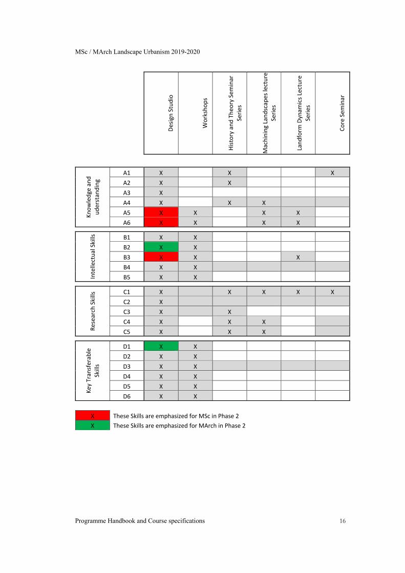
Teaching and Learning Methods The required knowledge is acquired through interaction with peers in course work either in their final group submission or individual workshops in first term. Assessment Research skills are primarily assessed through the Final Thesis, but also developed and assessed in the coursework. 3.3 Curriculum Map The following table outlines which parts of the course are responsible for delivering (shaded) and assessing (X) particular learning outcomes:
MSc / MArch Landscape Urbanism 2019-2020
Programme Handbook and Course specifications 16
Design Studio
Workshops
History and Theo
ry Sem
inar
Series
Machining Landscap
es lecture
Series
Landform
Dynam
ics Lecture
Series
Core Sem
inar
Knowledge and
uderstan
ding
A1 X X X
A2 X X
A3 X
A4 X X X
A5 X X X X
A6 X X X X
Intellectual Skills
B1 X X
B2 X X
B3 X X X
B4 X X
B5 X X
Research Skills C1 X X X X X
C2 X
C3 X X
C4 X X X
C5 X X X
Key Transferab
le
Skills
D1 X X
D2 X X
D3 X X
D4 X X
D5 X X
D6 X X
X These Skills are emphasized for MSc in Phase 2
X These Skills are emphasized for MArch in Phase 2
MSc / MArch Landscape Urbanism 2019-2020
Programme Handbook and Course specifications 17
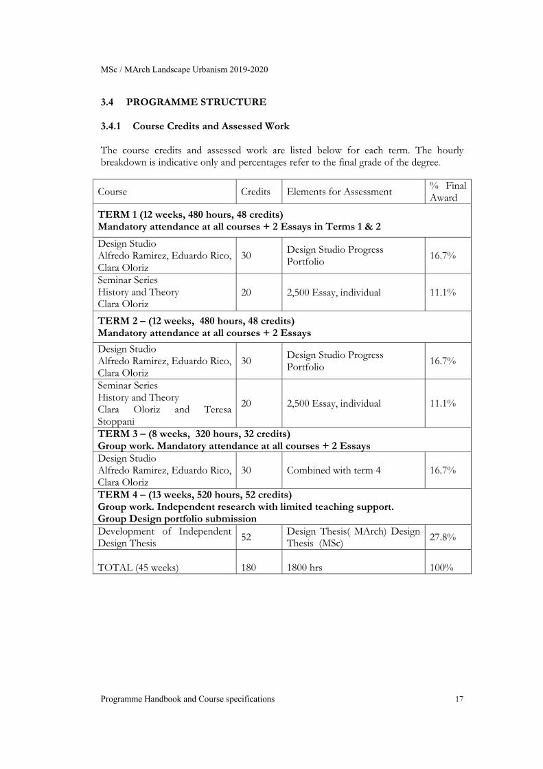
3.4 PROGRAMME STRUCTURE 3.4.1 Course Credits and Assessed Work The course credits and assessed work are listed below for each term. The hourly breakdown is indicative only and percentages refer to the final grade of the degree.
Course Credits Elements for Assessment % Final Award
TERM 1 (12 weeks, 480 hours, 48 credits) Mandatory attendance at all courses + 2 Essays in Terms 1 & 2
Design Studio Alfredo Ramirez, Eduardo Rico, Clara Oloriz
30 Design Studio Progress Portfolio 16.7%
Seminar Series History and Theory Clara Oloriz
20 2,500 Essay, individual 11.1%
TERM 2 – (12 weeks, 480 hours, 48 credits) Mandatory attendance at all courses + 2 Essays
Design Studio Alfredo Ramirez, Eduardo Rico, Clara Oloriz
30 Design Studio Progress Portfolio 16.7%
Seminar Series History and Theory Clara Oloriz and Teresa Stoppani
20 2,500 Essay, individual 11.1%
TERM 3 – (8 weeks, 320 hours, 32 credits) Group work. Mandatory attendance at all courses + 2 Essays Design Studio Alfredo Ramirez, Eduardo Rico, Clara Oloriz
30 Combined with term 4 16.7%
TERM 4 – (13 weeks, 520 hours, 52 credits) Group work. Independent research with limited teaching support. Group Design portfolio submission Development of Independent Design Thesis
52 Design Thesis( MArch) Design Thesis (MSc)
27.8%
TOTAL (45 weeks)
180
1800 hrs
100%
MSc / MArch Landscape Urbanism 2019-2020
Programme Handbook and Course specifications 18
4 COURSE SPECIFICATIONS & ACADEMIC CALENDAR Thinking practice through the concept of territory, the agency of the designer can be extended beyond its current disciplinary confinements: those of architecture, planning, urban design, landscape architecture, engineering, etc. as well as those of the various (un)-disciplinary re-alignments and hybrids in which these are currently configured. In the process, geographic knowledge and practices, such as cartography and geomorphology, are reappropriated and mobilised as the means to ask and respond to these fundamental questions. In doing so, the programme explores the types of project, forms of documentation, theories, technologies and techniques required to rethink and redefine the temporal production of territorial spaces through the praxis of design. It engages critically with a range of social and material formations in given territories, and with the conflicts that resonate at geographical scales of the local, the regional and the continental. The following sections describe the permanent and variable content of the course, the academic calendar and the programme modules and detail the submissions, credits, aims, learning outcomes, and assessment criteria for each: 4.1 Permanent and Variable Content of the Course The permanent year-to-year aspects of the programme are embedded in its structure, which consists of a combination of design studio and workshops, together with lecture and seminar courses that have been evolving within the programme since its inception. The aims and objectives of the programme, the learning outcomes and the assessment procedures also remain broadly similar from year to year, so that students are able to anticipate what constitutes the essential core of the programme and how their work will be assessed. The variable component of the programme has to do with the selection of a different agenda/site each year, in the context of which students are invited to develop a team- based design thesis. The choice of sites reflects the aim of the programme to keep abreast of current events and changing conditions in the global context. The following points outline the way in which the course delivers its contents to the students:
Term 1: The course starts by building up skills and theoretical background. The students are taught techniques of simulation, mapping and representation which are going to be a fundamental part of their future deliveries. These workshops include simulations, 3D modelling and GIS. Students work in groups which are different for each workshop. In parallel, there is a series of lectures on land formation which supports the simulation part of the work as well as general software and coding. The History and Theory seminar series brings basic theoretical background to the students andplaces the work of LU within a wider perspective. There is an overlap with the MArch students from the previous year
MSc / MArch Landscape Urbanism 2019-2020
Programme Handbook and Course specifications 19
that allows the new cohort to get acquainted with techniques and theories more effectively. Students work in teams which will shift in different workshops but submit a unique design portfolio at the end of the term.
Term 2: The students start to focus on their final course project and form definitive groups. During this term the groups are meant to generate an Atlas forming the wider geographical framework of their proposals. Both the History and Theory seminars and invited guest lecturers provide specific support for this part of the course whichfocuses mainly on cartography. Students work in teams composed of both MSc and MArch candidates.
Term 3: The focus of the studio is moreon the detailed definition of the project. During this period the amount of seminars is reduced to Core Seminar series which, while being reduced in number, is aimed at focusing the agenda of the students and linking them to the overall ethos of the course. Students work in teams composed of both MSc and MArch candidates.
Term 4: MSc: Students develop their individual thesis by focusing on the generation of a set of design guidelines that can potentially be deployed and transferred to comparable territories. It includes research on the design techniques (simulations, GIS, interactive mappings, etc) developed during the course. Tutorials are given to the students as per previous terms. Students work individually.
Term 4: MArch: Students develop the final thesis by focusing on detailed spatial and material strategies at architectural scales. Tutorials are given to students as per previous terms and they have the possibility of software reinforcement with the new series of workshops. Students work individually
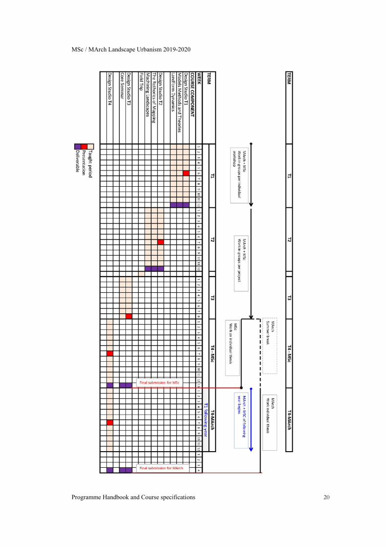
4.2 Academic Calendar Landscape Urbanism Programme is organised in two stages according to a specific calendar for MArch or MSC courses. The MSc Course runs for 12 months (September to September) and concludes with the Design Dissertation in Phase 2 The MArch Course runs for 16 months (September to January) and concludes with the Design Thesis in Phase 2. The number of hours and credits are identical in the MSc and the MArch (see section 6.1), but their distribution over time and the type and scopes of projects are different. See complete academic calendar overleaf:
MSc / MArch Landscape Urbanism 2019-2020
Programme Handbook and Course specifications 20
MSc / MArch Landscape Urbanism 2019-2020
Programme Handbook and Course specifications 21
The programme is organised around the Design Studio, with individual and group teaching available throughout the academic year, and on a more limited basis from July-September. Students are expected to attend the studio regularly and work in teams throughout most of the year. The studio is also where the various workshops are taught and is the central focus of the Masters where the dissertation comes together. A number of seminar series and theory courses feed into the studio at different times. 4.3 Phase 1 (Activities): Term 1: Territorial Formations
Workshop 1: Landscript Workshop 2: Social Formations Workshop 3: Manufactured Grounds
Seminar Series: Model, Methods and Histories Lecture Series: Landform Dynamics
Term 2 : Cartogenesis
Design Studio Development: Research and Territory, Design Studio Development: Atlas of Transferable Grounds Design Studio Development: Cartogenesis Lecture Series: Cartographies; Genealogies and Practices Seminar Series: The Rhetoric of Mapping Seminar Series: Machining Landscapes Field Trip
Term 3 : Tectonic Grounds
Design Studio Development: Territorial Morphology Design Studio Development: Tectonic Grounds Workshop 4: Digitally Fabricated Territories Lecture Series: Landscape Urbanism Lecture Series Seminar Series: Landscape Urbanism Core Seminar Seminar Series: Machining Landscapes
4.4 Phase 2 (Activities): Term 4 Design Thesis (MArch)
Design Thesis (MSc)
*MSc End of Year Board: September 2019 (to be confirmed) *MArch End of Year Board: January 20120 (to be confirmed)
MSc / MArch Landscape Urbanism 2019-2020
Programme Handbook and Course specifications 22
4.5 DESIGN STUDIO Jose Alfredo Ramírez, Eduardo Rico, Clara Oloriz Mandatory Course Credits: 116 % of final award: 64.4% Workshops: 150 hrs Tutorials: 300 hrs Personal project development: 480 hrs Project document submission: 230 hrs 4.5.1 Course Brief Design and the Green New Deal (GND) Given the climate and ecological emergency the world is facing, it is paramount to support a socially just re-structuration of the world we inhabit, intrinsically dependant on the health of the earth systems, and trigger, along the way, a radical transformation of the role designers can play in developing design proposals, mitigation strategies, advocacy initiatives and activism. One way to achieve this is by supporting a Green New Deal (GND) from those involved in designing landscapes (whether architects, landscape architects, artists, planners or engineers).To coordinate these efforts, AA Landscape Urbanism will get behind a project with the capacity to unite all the best intentions, preoccupations and existing proposals from the design community. This project is a GND and AA Landscape Urbanism will contribute to shape it in the UK. AA Landscape Urbanism design’ expertise on visualization, mapping and spatial understanding of socio ecological systems is crucial to such project and the challenges it will bring ahead and will develop proposals for a GND in collaboration with the New Economics Foundation through the exploration of different policies such as:
The transformation of a Common Agricultural Policy in a Post Brexit scenario and the impact it could have in local communities.
The rewilding of urban areas and the benefits in can bring to the wellbeing of citizens in both urban and rural environments.
The transition towards a post fossil fuel economy in the form of a Just Transition and the alternative models to drive the economy together with the impact it will have in space and the design of urbanisation processes.
The exploration of different land ownership schemes, beyond the current model of privatise and individual models, to radically transform UK landscape.
AA Landscape Urbanism will develop these policies with the use of concepts, practices and principles from designer’s perspective:
MSc / MArch Landscape Urbanism 2019-2020
Programme Handbook and Course specifications 23
Exploring cartographic practices with the capacity to influence the public sphere
and decision-making processes, such as interactive and participatory maps built by local people with data gathered on site.
Revisiting concepts such as commons through the lens of design, and their implications to build collecting design frameworks and management of shared resources that are neither public nor private.
Implementing latest technologies to simulate the behaviour of cities, landscapes, and territories, using software, scripts, to foresee possible future scenarios with the help of partner scientists and researchers.
Understanding the use of space, from a UK cultural perspective, by diagramming and proposing new spatial configuration of public space in accordance to 21st century challenges.
4.5.2 Learning Outcomes At the end of this course, students are expected to be able to: Make use of new systems of description and representation. Move across disciplinary boundaries. Be able to conduct an urban, territorial and landscape analysis in depth. Understand the existing processes of territorial formations in accordance to the
specific site context. Integrate these processes within flexible strategies in a fully developed individual
thesis. 4.5.3 Assessed Work Students are assessed with two Design Studio Progress Portfolios (Term 1 and Term 2) and a Final Thesis to be delivered throughout the course of the year: Design Studio Progress Portfolio These design portfolios will be delivered at the beginning of Terms 2 and 3 (See Submissions and Resubmission Map section). They should include drawings and description of the main outcomes and explorations regarding site specific research and development of associated techniques in relation to specific workshop exercises or the development of the Final Thesis. Final Design Thesis Students must submit a Final Design Thesis which outlines the aims, objectives and outcomes of their design project. This Project Report includes the following:
Site description. Text outlining aims, objectives and methodology. Landscape Urbanism Core Seminar Essay outlining the main argument of the
project. Technical component / report the research on building techniques, digital
simulations, tests and technical data supporting the overall project.
MSc / MArch Landscape Urbanism 2019-2020
Programme Handbook and Course specifications 24
Design experiments (workshop outcomes etc.). Main design outcomes. Images, renders.
The format of this document takes the shape of a booklet, although the amount of material (images, words) is not prescribed. Students have access to previous years’ Design Reports, which are discussed with the course staff in order to provide clear guidance of intended outcome. For submission dates please refer to the Submissions and Resubmission Map section. For weight and credits of each submission please refer to the Programme Summary section. 4.5.4 Assessment Criteria In order to achieve a Pass, the Final Design Portfolio is expected to demonstrate: Rigour in the collection and analysis of research information. An understanding of organisational techniques and digital skills from diverse fields
of expertise. An ability to establish, demonstrate and distinguish the different scales of time and
space at which diverse urban processes operate, and to formulate integrated responses to these processes.
Criticality in the analysis of urban models and agility in constructing new modes of organisation capable of operating in time.
Presentation skills enabling the final portfolio to be accessible and representative of the student’s achievement over the year.
4.5.5 Design Studio Outline Description per Term Territorial formations (Terms 1- 2) Landscape Urbanism aims to thread, during the first two terms, geomorphological processes, social structures and design intentions into Territorial Formations. Landscape Urbanism wants to extrapolate the idea of a necessary synthesis, of a forced hybridization from a utilitarian perspective to imagine new forms of territory where physical and social processes morph into new spatial solutions. They will rely on the historic capacity of landscapes to host and modulate the struggles between physical/environmental and the human forces, at its very specific geographical/geological point in space and time. Cartogenesis (Terms 2 - 3) The assemblages of geomorphological processes and social formations will be retraced and redescribed in light of historical and contemporary forms of cartographic representation. This will serve as the basis from which to fabricate a description of territorial space in architectural terms, and, at the same time, a territorial description of architectural space. The final aim of this term is the generation of an atlas of similar and
MSc / MArch Landscape Urbanism 2019-2020
Programme Handbook and Course specifications 25
relevant territories across Europe, tracing the geographies of the pan-European problematic posed by the social and geomorphological formations outlined and researched by the student. Territorial documentation (Term 4) The final section of the course will consist of the exploration of modes of documentation that extend, beyond the idea of the fixity and stability of masterplanning, to operate projectively and subversively. Following the development of an Atlas, the student will produce a territorial manual that will describe the procedures and guidelines behind their projects in order to extrapolate principles for similar, relevant locations across European territories. 4.5.6 Design Studio Workshops LU Bootcamp: Skill Gathering (Term 1) projects. Rhino and grasshopper skills will be acquired next to communication and representational drawing skills. GIS Software and programming will be introduced enabling students to script basic procedural modelling, and to understand the ways in which physical interactions of materials and processes produce recognisable morphologies in the landscape. The use of relevant software, such as GIS, Phyton, Rhino as well as land form modelling will be used to exercise student’s capacity to introduce intention and design criteria in a decision-making process. Social formations (Terms 1 - 2) This workshop will seek an understanding of processes of social formation, their multiple forms of organization and the ways in which these produce specific spatial configurations. The student will diagram and ultimately employ in their design practice, their knowledge of the ways in which specific groups have historically organised themselves into productive communities such as, for example, trade unions, local associations, guilds, cartels and cooperatives, and ultimately their impact on the land morphologies. Cartogenesis (Terms 2 -3) The aim of the workshop is the generation of a series of cartographical representations of the projects. This workshop will introduce the idea of projective cartographies with a critical input, in order to produce a cartogenesis manifesto of the pan-European intentions of the project. 4.5.7 Field Trip An individual field trip to different sites across Europe will be encouraged for all students by the end of Term 2, in order to visit and survey potential sites, to access specific sources of information and arrange meetings with local practitioners, engineers, researchers and interested parties. 4.5.8 Design Studio Bibliography
MSc / MArch Landscape Urbanism 2019-2020
Programme Handbook and Course specifications 26
Cosgrove, D. Social Formations and Symbolic Landscape (London: University of Wisconsin Press, 1998). Elden, S. The Birth of Territory( Chicago: University of Chicago Press, 2013). Spencer, D. ‘Nature is the dummy’in New Geographies Journal, 06, 2014, pp. 112-117. Wood, D. Rethinking the Power of Maps (New York: The Guilford Press, 2010).
Shane, G. ‘The Emergence of “Landscape Urbanism”’ in Harvard Design Magazine, Fall 2003/Winter 2004, Number 19. Shane, G. Recombinant Urbanism (John Wiley & Sons, 2005). Graham, S., Marvin, S., Splintering Urbanism: Networked Infrastructures, Technological Mobilities and the Urban Condition (London and New York: Routledge, 2001). Maki, Fumihiko, ‘Some Thoughts on Collective Form’, in Mulligan, Mark, Nurturing Dreams: Collected Essays on Architecture and the City, (MIT Press, 2008). Carpo, M. The Alphabet and the Algorithm (Cambridge: MIT Press, 2011). Spencer, D. The Architecture of Neoliberism: How Contemporary Architecture Became an Instrument of Control and Compliance. (London: Bloomsbury, 2016) Toscano, A. Kinkle, J. Cartographies of the Absolute (London: Zero Books, 2015) Scott, Felicity D. Outlaw Territories, (MIT, Press, 2016) Easterling, K. Extrastatecraft, (Verso, 2016) Grinspoon, D. Earth in human hands (Grand Central Publishing, 2016)
MSc / MArch Landscape Urbanism 2019-2020
Programme Handbook and Course specifications 27
4.6 LANDSCAPE URBANISM: MODELS METHODS AND CONCEPTS SEMINAR
Clara Oloriz Mandatory Course Credits: 26 (13 in Term 1 and 13 in Term 2) % of final award: 14.4% Contact (lectures & tutorials): 40 hrs Research & reading: 110 hrs Essay: 110 hrs Terms 1 & 2 Wednesday 2pm SYNOPSIS
This lecture and seminar-based course is concerned with the ways in which the intersections and interactions of landscape and urbanism have been thought, modelled, designed and analysed. It is designed to introduce the student to a critical engagement with these matters that will inform an understanding of the potentials and problematics of Landscape Urbanism. This, in turn, is designed to support practice and development within the studios, workshops, field trips and other seminars.
AIMS
The purpose of this seminar is to introduce the main concepts which underpin the overall course ethos and methodologies. It should provide a robust framework for discussion of the development of the student projects within the studio as well as facilitate links to other seminars and parts of the course.
CONTENT
SESSION 1: Landscape: The meanings and significance of the term landscape SESSION 2: Social Formations: Venice SESSION 3: Territory, Terrain, Territorialisation SESSION 4: Consequential Landscapes and Nature SESSION 5: Infrastructure and the Urban/Rural. SESSION 6: Design Agency SESSION 7: Time SESSION 8: Essay Tutorials
LEARNING OUTCOMES OF THE MODULE OR COURSE
At the end of the course, students should be able to:
MSc / MArch Landscape Urbanism 2019-2020
Programme Handbook and Course specifications 28
Understand the contribution of various disciplines to Landscape Urbanism. Critically assess the contribution and significance of various ideas and practices
to Landscape Urbanism. Demonstrate a critical and informed comprehension of Landscape Urbanism as
a specific design practice. Contextualise Landscape Urbanism with reference to specific examples of its
contemporary practice. Develop a personal critical agenda which informs their practice.
ASSESSMENT METHOD
Students will select projects to investigate and discuss (an overview and list of suggestions will be provided at the beginning of the term.) The work for each term will be to write an essay of 2,500 words, analysing the critical content of an urban project, and linking the analysis of the project to current debates within architectural urbanism, to be submitted at the end of Terms 1 and 2 respectively. For submission dates please refer to the Submissions and Resubmission Map section. For weight and credits for this submission please refer to the Programme Summary: Credits and Assessed Works section.
ASSESSMENT CRITERIA
In acknowledging the range of student experience and interests, the assessment criteria will reflect this diversity and respond to the scholarly objectives of individual students. However, emphasis will be placed on the following core criteria:
Content – analysis, contextualisation, argument, debate, structure
Research – range, selection and use of resources
Communication – writing, illustration, annotation and account of sources
DETAILED COURSE GUIDE 1. 27 September 2019
Landscape as Territory The meanings and significance of the term landscape Olóriz Sanjuán, C. Introduction. In: Landscape as territory, Actar, 2019. Cosgrove, D., 1998. The idea of landscape. In: Social formation and symbolic landscape. Madison: University of Wisconsin Press. Additional readings: Cosgrove, Denis, E., ‘England: Prospects Palladianism and Paternal Landscapes’ in Social Formation and Symbolic Landscape, Wisconsin and London: University of Wisconsin Press, 1998, pp. 184-222.
MSc / MArch Landscape Urbanism 2019-2020
Programme Handbook and Course specifications 29
Cosgrove, Denis, E., ‘Sublime Nature: Landscape and Industrial Capitalism’ in Social Formation and Symbolic Landscape, Wisconsin and London: University of Wisconsin Press, 1998, pp. 223-253. 2. 09 October 2019
Social Formations: Venice An example of the analysis of ‘social formations’ in the writing of Cosgrove, focusing upon Venice. Cosgrove, Denis, E., ‘Landscape and Social Formation: Theoretical Considerations’ in Social Formation and Symbolic Landscape, Wisconsin and London: University of Wisconsin Press, 1998, pp. 39-68. Cosgrove, Denis, E, ‘Venice, the Veneto and Sixteenth-century Landscape’ in Social Formation and Symbolic Landscape, Wisconsin and London: University of Wisconsin Press, 1998, pp. 102-142. Additional readings: Tafuri, Manfredo, Venice and the Renaissance, trans. J. Levine, Cambridge, MA: MIT Press, 1995. 3. 16 October 2019
Territory, Terrain, Re-territorialisation An examination of Elden’s notion of territory and cognate terms to reflect on their relationship to landscape. Elden, S., 2017. Legal terrain–the political materiality of territory. London Review of International Law, 5(2), pp. 199-224. (Lecture: https://progressivegeographies.com/2017/06/15/legal-terrain-video-of-my-london-review-of-international-law-lecture/) Elden, S., Territory: political technology, volume, terrain. (AA Lecture: https://www.youtube.com/watch?v=-QiS714BXxc) Elden, Stuart. 2006. “The State of Territory under Globalization: Empire and the Politics of Reterritorialization.” Thamyris Intersecting Place Sex and Race, no. 12: 47–66. Additional readings: Elden, Stuart. “Land, terrain, territory.” Progress in Human Geography 6, no. 34 (2010): 799-817. Elden, S., Forthcoming. Territory/territoriality. In: The Wiley-Blackwell Encyclopedia of Urban and Regional Studies. s.l.: Wiley-Blackwell. 4. 23 October 2019
Consequential Landscapes and Nature Looking at the relationship between produced landscapes and reterritorialisation from the previous session, it includes an exploration of the role that nature, and ideas of nature, have played in the practice and thought of architecture, urbanism and landscape design. As a consequence of these practices and mentalities, we will explore the urban/rural division. Hutton, Jane, Reciprocal landscapes: material portraits in New York City and elsewhere, Journal of Landscape Architecture, 8:1, 2013, pp. 40-47. Spencer, Douglas, ‘Nature is the Dummy’, Ungrounding Metabolism: New Geographies 06, 2014,
MSc / MArch Landscape Urbanism 2019-2020
Programme Handbook and Course specifications 30
pp.112-117. 5. 6 November 2019
Landscape and the Neoliberal City Guest Will Jennings Jennings, W, ‘English Landscape & The Neoliberal City. From Capability Brown To Business Improvement Districts (Via Le Nôtre, Price, Haussmann, Debord & Heatherwick)’ in https://medium.com/@willjennings80/the-deployment-of-landscape-in-the-neoliberal-city-85753150f56a https://medium.com/@willjennings80/a-london-nature-deriv%C3%A9-7aa467b61344 Additional readings: TBC 6. 20 November 2019
Re-territorialisation apparatuses: Infrastructure An analysis of how infrastructures, far from simple ‘services’ to the life of the city and territory, shape and organize its social, cultural and even psychological relations. We will look at infrastructures and production techniques as forms of reterritorialisation. Gandy, Matthew, ‘The Paris Sewers and the Rationalization of Urban Space’, in Transactions of the Institute of British Geographers, New Series, Vol. 24, No. 1, 1999, pp. 23-44. Candiani, V. 2014. Dreaming of Dry Land: Environmental Transformation in Colonial Mexico City. Stanford university Press, Stanford: 408p. ISBN: 978-0-8047-8805-2. Sigler, T. J., 2014. Panama as palimpsest: the reformulation of the 'transit corridor' in a global economy. International Journal of Urban and Regional Research, 38(3), pp. 886-902. Brenner, Neil. Implosions/Explosions. Towards a Study of Planetary Urbanization, Berlin: Jovis Verlag,
2014. 7. 27 November 2019
Agency Drawing on the previously discussed ideas about consequential landscapes and reterritorialisation, this session reflects on the question of agency. Understanding the temporal condition of agency, we will critically explore notions and definitions of time. Malm, Andreas. 2018. "Introduction" The Progress of This Storm: Nature and Society in a Warming World. Verso Books. Malm, Andreas. 2018. "On what matter does: Against new materialism" The Progress of This Storm: Nature and Society in a Warming World. Verso Books. Spencer, D., 2017. Agency and artifice in the environment of Neoliberalism. In: E. Wall & T. Waterman, eds. Landscape and Agency: Critical Essays. Milton Park, Abingdon, Oxon and New York, NY: Routledge, pp. 177-187.
MSc / MArch Landscape Urbanism 2019-2020
Programme Handbook and Course specifications 31
Additional sources: Spencer, Douglas. Withdrawn. This thing called theory, AA Lecture. https://www.aaschool.ac.uk/VIDEO/lecture.php?ID=3875 8. 11 December 2019
Essay Tutorials
MSc / MArch Landscape Urbanism 2019-2020
Programme Handbook and Course specifications 32
4.7 LANDSCAPE URBANISM: THE RHETORICS OF MAPPING
SYNOPSIS
This seminar addresses key points and practices in the historical development of cartography as a representational device. Methods of mapping are explored in terms of their uses, implications and potential so as to critically inform the drafting of a cartogenetic manifesto and the writing of the final project thesis.
AIMS
The purpose of this seminar is to introduce the main concepts which underpin the practice of historical and contemporary practice of cartography. It provides a robust framework for discussion of the development of the student projects based of the representational skills but most importantly the critical approach and reflection of cartography as a medium of representation within the studio. It also aims to serve as the link between theoretical approaches and practices within cartography and within the programme.
CONTENT
SESSION 1: Projective Cartographies SESSION 2: How to assemble the globe: Radical Cartographies SESSION 3: Excavation, Archaeology and Geology SESSION 4: Cartographies of Knowledge and Power SESSION 5: Information: Dataspaces and Networks SESSION 6: Projections SESSION 7: Meta-geographies and Planetary Urbanisation SESSION 8: Essay Tutorials
LEARNING OUTCOMES OF THE MODULE OR COURSE
At the end of the course, students should be able to:
Understand the contribution of various geographical, cartographical and other disciplines to Landscape Urbanism.
Critically assess the contribution and significance of various ideas and practices that relates practices of cartographic representation to Landscape Urbanism.
Demonstrate a critical and informed comprehension of Cartography within Landscape Urbanism as a specific design practice.
Contextualise Landscape Urbanism with reference to specific examples of contemporary practices of representation.
Develop a personal critical agenda and thinking to inform their practice.
MSc / MArch Landscape Urbanism 2019-2020
Programme Handbook and Course specifications 33
ASSESSMENT METHOD
Students will select projects and specific cartographies to investigate and discuss (an overview and list of suggestions will be provided at the beginning of the term.) The work for each term will be to write an essay of 2,500 words, analysing the critical content of an urban project, and linking the analysis of the project to current debates within geographical and cartographic practices linked to urbanism, to be submitted at the end of Terms 1 and 2 respectively. For weight and credits for this submission please refer to the Programme Summary: Credits and Assessed Works section within the AA Landscape Urbanism Programme Handbook.
ASSESSMENT CRITERIA
In acknowledging the range of student experience and interests, the assessment criteria will reflect this diversity and respond to the scholarly objectives of individual students. However, emphasis will be placed on the following core criteria:
Content – analysis, contextualisation, argument, debate, structure
Research – range, selection and use of resources
Communication – writing, illustration, annotation and account of sources
DETAILED COURSE GUIDE 1. Projective Cartographies Cosgrove, D. (2006) ‘Carto-City’ in: Abrams, J. Hall, P. (eds.) Else/Where: Mapping. New Cartographies of Networks and Territories, University of Minnesota Design Institute, pp. 148-157. 2. ‘How to Assemble the Globe’: Radical Cartographies Corner, J., ‘The Agency of Mapping: Speculation. Critique and Invention’ in Denis Cosgrove, ed. Mappings, Reaktion, London, 1999. Denes, A., Map Projections: Isometric Systems in Isotropic Space, Visual Studies Workshop Press, 1979. Fuller, B. Ideas and Integrities, Lars Muller, Baden, Switzerland 2009 (1969). 3. Excavation, Archaeology and Geology Pointon, M., ‘Geology and Landscape Painting in Nineteenth-century England.’ In Images of the Earth. Essays in the History of Environmental Sciences, edited by Ludmilla Jordanova and Roy Porter. Oxford: The Alden Press, 1979, 84-108. Williams, R., ‘Excavations 1: Digging Down to the Truth’, in Notes on the Underground: An Essay on Technology, Society, and the Imagination, MIT: Cambridge, MA, 2008, pp. 23-51.
MSc / MArch Landscape Urbanism 2019-2020
Programme Handbook and Course specifications 34
4. Cartographies of Knowledge and Power Crampton, J. and Elden, S., eds, Space, Knowledge and Power: Foucault and Geography, Aldershot: Ashgate, 2007. Wood, D., Rethinking the Power of Maps, Guilford: Guilford Press, 2010. Mattelart, A., ‘Mapping Modernity: Utopia and Communication Networks’ in Cosgrove, D., ed, Mappings, London: Reaktion, 1999. 5. Information: Datascapes and Networks Crampton, Jeremy W. Mapping. A Critical Introduction to Cartography and GIS (Oxford:Wiley-Blackwell, 2010). Kurgan, L., Close Up at a Distance: Mapping,Technology (Cambridge, MA: MIT Press, 2013). Mass, W. MVRDC: Datacity Metatown (Rotterdam: 010,1999). Pickles, J. ed. Ground Truth: The Social Implications of Geographic Information Systems (Guilford: Guilford Press, 1995). 6. Projections: Is the Earth Curved or Flat? Guest: Mark Duffield (Global Insecurities Centre, University of Bristol) Duffield, M., ‘Is the Earth Curved or Flat?’, 2017, available at <https://www.bristol.ac.uk/media-library/sites/global-insecurities/documents/Duffield_Curved%20or%20Flat_April%2017.pdf> Duffield, M., 'The Death of Humanitarianism' LA Review of Books (November 26, 2018) see: https://lareviewofbooks.org/article/the-death-of-humanitarianism/ 7. Metageographies of Planetary Urbanization Guest: Nikos Katsikis (Urban Theory Lab, Harvard GSD) Brenner, Neil, and Nikos Katsikis. "Is the Mediterranean urban." Implosions/explosions: Towards a study of planetary urbanization (2014): 428-459. Urban Theory Lab-GSD (Neil Brenner, Nikos Katsikis, Danika Cooper, Ghazal Jafari), “Visualizing an urbanized planet—materials,” in Neil Brenner (ed.), Implosions/Explosions: Towards a Study of Planetary Urbanization. Berlin: Jovis, 2013, 460-475. Taylor, Peter J. "Metageographical moments: a geohistorical interpretation of embedded statism and globalization." Odysseys. London: Routledge (2002). 8. Essay Tutorials
MSc / MArch Landscape Urbanism 2019-2020
Programme Handbook and Course specifications 35
MSc / MArch Landscape Urbanism 2019-2020
Programme Handbook and Course specifications 36
4.8 NEW ECONOMICS AND THE PROCUTION OF SPACE This seminar explores new economic thinking, knowledge and concepts being developed as an alternative to the existing neoliberal system. Run by the New Economics Foundation and moderated by Landscape Urbanism, this series of lectures and seminars allows students to understand the dynamics of today’s economy and the strong impact it has in the production of landscapes and territories around us. The course is planned for students to reflect on the intricate relation between the design of space and the design of economic policies and explores potential avenues through which the production of new regulation and policies can be influenced by design methodologies at the local, regional, national and even planetary scale. AIMS
The aim of the series of lectures and seminars is to build the capacity of the landscape urbanism programme and designers to explore the role they can play in delivering economic and public policy change and assess the spatial impact those policies will produce in the built environment. CONTENT
SESSION 1: New Economics Models
SESSION 2: Theory of Change
SESSION 3: Contemporary conditions of Land and Hosing in UK
SESSION 4: Rewilding Britain
SESSION 5: Climate emergency
SESSION 6: Digital economy
SESSION 7: Just Transition
SESSION 8: Green New Deal
LEARNING OUTCOMES
Students will have a general understanding on how to tackle complex problems and transform the economic system in close coordination and collaboration with other disciples such as economists.
The students will be able to integrate as part of their dissertations, projects or design thesis principles related to economic systems in relation to the co-creation of more resilient and inclusive communities.
Students will be able to explore the material, spatial and political consequences of economic policies in the landscape and vice versa, how landscape design and influences economic dynamics.
ASSESSMENT CRITERIA
In acknowledging the range of student experience and interests, the assessment criteria will reflect this diversity and respond to the scholarly objectives of individual students.
MSc / MArch Landscape Urbanism 2019-2020
Programme Handbook and Course specifications 37
5 TEACHING AND LEARNING STRATEGIES The programme’s design studios, computational workshops, seminars and lectures are thematically and pedagogically related, providing students with the necessary information, knowledge, skills, and guidance to undertake the required project work and complete the programme. The programme is organized around a DESIGN STUDIO which is theoretically supported by a series of SEMINARS AND LECTURES and a FIELD TRIP to collect and verify data. The Design Studio is based on a series of weekly tutorials and intensive workshops. Both Design Studio and Seminars and Lectures provide individual and group tutorials and teaching available throughout the academic year, and on a more limited basis from July toSeptember. The principal process of learning in the programme is the development of the students’ personal and team agendas throughout the year, which starts with a series of short-term group workshops in Term 1, tailored to acquire a wide range of tools and geared toward long-term group proposals. It then moves to development of group agendas in Terms 2 and 3 for group projects to focus during Term 4 on the development of an Atlas of Similar Territories thesis (MSc during summer) or a comprehensive design project at Territorial Scales (MArch following autumn). The learning processes of the programme can be summarised as follows:
Undertaking design research, which must be completed and presented at given stages of the programme.
Attending prescribed lectures and participating in seminars which include readings and group discussions.
Researching and writing individual essays related to core seminars and lectures. Taking part in field trips and workshops. Attending open evening lectures and other special events organised by the AA Preparing digital and physical portfolios. Preparing a printed and bound document of the individual design development
by Term 1 and 2 and group design thesis by the end of the programme. 5.1 Design Studio Objectives The objectives of the Design Studio are as follows:
To construct a discipline capable of integrating several modes of operation derived from concepts such as landscape and territory into design practices related with urban environments.
To construct ways of moving across disciplinary boundaries (architecture, landscape architecture, geography, planning) by reconfiguring, decoding and re-coding diverse techniques of organization and description.
To develop operative mechanisms to engage in the rapid transformations of cities and of the landscape.
MSc / MArch Landscape Urbanism 2019-2020
Programme Handbook and Course specifications 38
To reconsider established modes of temporal development in order to speculate with precision about their future.
To understand both the city and the landscape as a compound of the sediments of processes of material evolution happening at several scales, and to construct ways of intervening directly in these processes.
To evolve new mixtures between landscape and urban materials that can help reformulate existing urban typologies.
5.2 Design Studio Structure The Design Studio activity is structured over the course of three terms + thesis work (MArch) 16 months or Dissertation work (MSC) 12 months. During the programme students are taught how to construct and design systematically techniques and arguments capable of describing and correlating temporal processes relating to Landscape Urbanism agendas. The Studio remains open during the summer, and contact arrangements are made with Programme Staff to ensure that tutorials are available. The School itself is open throughout the summer (with the exception of one week’s closure period), with members of the Registrar’s Office and Graduate School co-ordinators Office Staff always on hand. Workshops Workshops (from one to three weeks) are inserted into this programme in order to familiarise students with digital mapping techniques, introduce new forms of software, and offer techniques and processes for abstracting dynamic organisations. This should be incorporated within the design work/project during the overall duration of the studio. The assessment of the student performance within the workshop is carried out in short presentations at the end of these workshops. These are set up with members of the Studio Staff and invited guests, in order to further particular areas of expertise. Seminar and Lecture Series The studio is supported by Seminar and Lecture Series that take place during Terms 1, 2 and 3. In addition to mandatory attendance at these events, students are required to make presentations and to undertake a series of essays with a total of 10,000 words produced during the year. All essays must be completed and passed in order to be eligible for the Degree Award. A series of weekly seminars, approximately two hours in length, are followed by an opportunity for students to discuss the issues raised. Appropriate reading for each lecture is indicated in advance, with a broader reading list provided for each seminar. The general aim of the Lecture and Seminar Series is:
To offer a critical theoretical basis for Studio Work.
MSc / MArch Landscape Urbanism 2019-2020
Programme Handbook and Course specifications 39
To provide a broad platform of knowledge of contemporary landscape and urban projects being undertaken in Europe and worldwide that demonstrate issues and methodologies relevant to the Studio Work.
To provide technical information concerning the ecological and sustainable issues that inform current work.
To promote independent research and its synthesis in written papers.
Tutorials
Within all modules, the progress of students is monitored and assisted through regular weekly individual and group tutorials. The modules have appointed tutors who are available at scheduled times. However, teaching staff are available for additional tutorials if necessary. Project Presentations and Reviews Individual and group presentations are regular events and part of all modules. Their aim is to develop presentation skills, but also serve to monitor progress by staff as well as between peers. Field Trip A study trip to a location chosen for the Studio project agenda of the year takes place generally at the end of Term 2, in order for students to examine specific site conditions, access sources of information, and meet with local practitioners and researchers. Students select the site to be visited on a group basis according to the previous research and project location. Special events, such as symposia or reviews with other students, depend on the topics and interests of the on-going research agendas. Elective Courses Students who need to acquire or refresh skills and knowledge may take, with prior agreement of the Directors, one additional Course from those that are provided within the Graduate School. 5.3 Student Feedback Students play an important part in the continued development of the programme, and all tutors welcome student feedback. Group and individual meetings take place at the end of each term, and again at the end of the year, to discuss the range of activities and student response to the content and methodology of the programme. Suggestions from students are discussed by the GMC (Graduate Management Committee) in the planning of the next year’s programmes. Feedback is obtained in the following ways:
MSc / MArch Landscape Urbanism 2019-2020
Programme Handbook and Course specifications 40
a) In course evaluation sessions at the end of each term. In these interviews the staff directors meet the students and discuss the term, obtaining interesting feedback as to what are the aspects of the course that work well and which ones can be improved.
b) Direct requests and informal discussion of individual concerns arising in the course of tutorials or studio meetings.
c) In Programme Evaluation Forms submitted by students during the year and at completion.
Students can also give feedback through institutional representatives of students who attend in the GMC and Student Board. 5.4 Student Support The AA offers a number of facilities to support students in their studies and help with any personal problems. During the initial Introduction week all new students are introduced to the facilities of the AA. The Graduate School administrative co-ordinators are available at all times to answer any queries and provide official letters and all other relevant documentation. The School Registrar deals with financial problems, is responsible for visa letters, and advises students on pastoral matters. Within the Landscape Urbanism Studio, Programme Staff have access to students on a daily basis and will be the first to be approached concerning any study problems. The Director of the School provides an ‘open-door’ policy for all students within the undergraduate and graduates programmes. All students experiencing difficulties personally or with their studies should initially consult with and notify their Programme Directors/Course Masters/Tutors. Following this initial meeting the student should then contact and arrange to meet with the AA Registrar, Belinda Flaherty: ([email protected]). Further meetings can be arranged with Jorge Fiori, Head of the Graduate Management Committee, if the matter is related to academic or study activities. Students are encouraged to contact staff quickly regarding any issues or concerns that arise at any time throughout the year.
MSc / MArch Landscape Urbanism 2019-2020
Programme Handbook and Course specifications 41
6 ASSESSMENT PROCEDURES Students are continually assessed during tutorials, presentations and reviews throughout the programme, as well as through their participation and contribution in the design studio, workshops and seminars. The formally assessed work is based on both students’ individual and group submissions which are Design Studio Portfolios, Seminar Essays, and the final Design Thesis. Formally assessed work is submitted to the Graduate School Coordinator at given deadlines and times. All submissions are assessed and marked by two members of the programme’s teaching staff and written reports and grades are given to the students. Students receive further informal feedback on their assessment during tutorials. The Examination Board, composed of the programme’s teaching staff and external examiner, held shortly after the given final submission date for each degree (MArch & MSc), reviews all marks and assessments for final approval and confirmation. The role of the external examiner is to ensure fair and objective marking and the maintaining of high academic standards. The external examiner will receive samples of submissions in time for the meeting of the Examination Board. The Examination Board has the responsibility for the final marking and for making recommendations on the award of distinctions or the need for resubmission. The decision by the Examination Board is final. The Examination Board reports to the Joint Assessment Board, which in turn informs the AA Graduate School’s Management Committee (GMC). The GMC reports to The Open University, the validating body for the AA School’s Masters programmes. Notification of results is given to students by the Registrar’s Office through the Graduate School’s Administrative Coordinator. 6.1 Assessment Criteria and Grading The assessment of submitted work is based on the following overall assessment criteria. Specific criteria for each Design Studio and Seminar Course are given in the description of each course and Studio in Section 8:
1. A systematic understanding of knowledge, and a critical awareness of current problems and insights at, or informed by, the forefront of the architectural, landscape and urban design disciplines and their practices.
2. A comprehensive understanding of techniques applicable to their own research or advanced scholarship.
3. Originality in the application of knowledge, together with a practical understanding of how established techniques of research and enquiry are used to create and interpret knowledge in the discipline; how the boundaries of knowledge are advanced through research.
4. Conceptual understanding that enables them:
MSc / MArch Landscape Urbanism 2019-2020
Programme Handbook and Course specifications 42
- to evaluate critically current research and advanced scholarship in the discipline; and - to evaluate methodologies and develop critiques of them and to propose new hypotheses.
The coursework is marked numerically on a percentage scale. The grades are given on the basis of the assessment criteria above and the relevant syllabus for each coursework. Assessment Grading The marking of all coursework is on a scale of 0-100% with a minimum pass mark of 50%, equivalent to a grading and performance assessment as shown below: New Marking Scheme (applicable to students entering the programme in 2015)
70 and above = A Excellent Pass/Distinction
65-69 = B+ High Pass
60-64 = B Good Pass
57-59 = C+ Satisfactory Pass
54-56 = C Adequate Pass
50-53 = D Low Pass
49 and below = Fail
Excellent Pass/Distinction=A (70% and above) Exceptional, creative and critical work demonstrating insight and outstanding analysis and development of all issues and concepts of the programme. Uses full range of sources to provide selective evidence to arguments. Coherently structured and compellingly presented. Clearly demonstrates originality, independent thought, and rigour. The student advances the boundaries of disciplinary knowledge based on the brief, indicating the way in which the discipline of Landscape Urbanism can move in the future, creating a new personal agenda relevant for the course. There is also a clear and realistic build-up of the project agenda which is successfully fulfilled and surpassed throughout the year. The student shows a productive synergy between different parts of the course, discovering ways in which the results of one become stronger through the mastering of the other. The project design material in combination with its theoretical reflection becomes a referent for future students and forms part of the showcase repertoire and publishable material for the programme.
MSc / MArch Landscape Urbanism 2019-2020
Programme Handbook and Course specifications 43
High Pass=B+ (65-69%) Excellent, creative critical work with outstanding knowledge of material. Excellent analysis and design development of key issues and concepts. Uses full range of sources to provide selective evidence to arguments. Coherently structured and compellingly presented. Demonstrates originality, independence of thought, and rigour. The student fulfils the goals of the course, achieving a comprehensive level in all of the sections of the programme. The student shows understanding of previous benchmarks of excellence within the course, keeping up production and managing to push his/her own agenda. The project manages to show interesting combinations and development (theoretical – technical, design – theoretical, etc) and produces outstanding results in certain aspects of the project. Good Pass=B (60-64%) Coherent creative work demonstrating critical analysis. Independent, critical analysis of full range of sources. Partially original in arguments and work. Presents complex issues and concepts using key sources effectively. Arguments are concise and explicit. Approaching excellence in parts and shows research abilities. The project achieves success in most of the sections of the course, both methodological, theoretical and technical. The student succeeds in setting a project agenda and fulfilling its expectations in a correct and clear manner. There is a clear understanding of previous years’ excellence benchmarks and the student navigates the different course components in order to reach some of them. Satisfactory Pass=C+ (57-59%) Coherent creative work demonstrating critical analysis. Independent, critical analysis of full range of sources. Partially original in arguments and work. Presents complex issues and concepts using key sources effectively. Arguments are concise and explicit. Good degree of accuracy and technical competence. Adequate Pass=C (54-56%) Coherent, logical work showing understanding of basic principles. Capacity to reflect critically but without significant evidence of originality. Sound knowledge of key issues and concepts and relevant primary and secondary sources. Developed arguments that are partially descriptive and only partially accurate. Approaching good analysis in parts but work is incomplete. Low Pass=D (50-53%) Coherent, logical work showing understanding of basic principles. Capacity to reflect critically but without evidence of originality. Sound knowledge of key issues and concepts and relevant primary and secondary sources. Narrow arguments that are partially descriptive and only partially accurate. Broadly satisfactory fulfilling the requirements of the curriculum. Fail (49% and below) The design principles of the course are poorly grasped and do not translate into the work. The project brief is unclear and the production does not respond to the expectations raised. The work carried out in the different parts of the course is unconnected and does not manage to produce an overarching design and theoretical argument.
MSc / MArch Landscape Urbanism 2019-2020
Programme Handbook and Course specifications 44
All coursework is marked by two internal assessors. Their marks are averaged to establish a moderated mark for each graded submission. Where the result of the assessment calculation creates a mark of 0.5% or greater, this will be rounded up to the next full percentage point (e.g. 69.5% is rounded to 70). Where the calculation creates a mark below 0.5% this will be rounded down to the next full percentage point (e.g. 69.4% is rounded to 69%). For the purposes of rounding up or down, only the first decimal place is used. The minimum pass requirement to qualify for both degrees MSc and MArch in Landscape Urbanism is a 50% mark for all submitted coursework. The final degree mark is calculated as the weighted average of all submissions. For the award of Distinction, the overall mean mark will be 70% or above. (For students entering prior to 2015, to be awarded a Distinction, only the Final Thesis mark is considered and has to achieve a minimum of 80%). Grades other than the final mark are kept on record and listed on transcripts, but do not appear on the degree certificate. In cases where there are no accepted mitigating circumstances and where coursework is submitted late, marks will be deducted. Any element of assessed work submitted up to seven days after the deadline will be marked and 10 marks (on a scale of 100), will be deducted for that element, for each calendar day of lateness incurred. Any piece of work submitted 7 or more days after the deadline will not be assessed and assigned a mark of 0, unless the student submits personal circumstances and these are accepted. (For students entering prior to 2015, non-submission or late-submission without extenuating circumstances are recorded as a ‘Fail’). Failure to attend at least 80% of the activities of coursework without mitigating circumstances will result in a student failing the specific coursework and in repeated cases the programme. Students who fail to attain an average of 50% for their Final Thesis will be allowed to resubmit once for the Examination Board of the following academic year.
Failure to resubmit and achieve a pass mark of at least 50% will result in the withdrawal from the programme on academic grounds. Submissions failed or recorded as failed can only be resubmitted once. Resubmissions after non- or unjustified late-submission are capped at 50%. Guidance from programme staff during the preparation of any resubmission is available. The assessment methods and criteria are aligned to those set in the AA Academic Regulation Document: http://www.aaschool.ac.uk/downloads/studentDocuments2014/AA_School_Academic_Regulations_2014-2015.pdf 6.2 Plagiarism
MSc / MArch Landscape Urbanism 2019-2020
Programme Handbook and Course specifications 45
Plagiarism is defined as stealing another person’s work and ideas and using them as though they were your own. It is plagiarism if you do not acknowledge the co-operation of another person who works with you or who gives you permission to use their work or if you use research without crediting the source. Student work substitution is the submission of another student’s work in entirety. Plagiarism and student work substitution are very serious offences at the AA School and these practices are considered unacceptable and can lead to failure and removal from the School. Students who offend in this respect will be warned during individual tutorials/group tutorials following the preliminary consultations of the design work/coursework. In the case of suspicion of any such practice in relation to submitted design work/coursework the student will be called to meet with Programme Directors/Unit Masters/Course Programme Masters/Registrar. If there is inconclusive evidence of dishonest intent the student will be given one opportunity of resubmission. In a case of clear evidence of improper practices the submission will be passed to either members of the Undergraduate Group or the Graduate Management Committee for review and discussion. Extensive and systematic dishonesty will be penalised and the School may impose any or all of the following penalties on a student found guilty of plagiarism:
Removal from the School, without right of resubmission;
Suspension from registration at the School or in particular courses for such period as it thinks fit;
Denial of credit or partial credit in any course, courses or design work (portfolio);
An official letter of warning/conclusion to be issued within two working days of the decision taken.
Plagiarism Prevention Turnitin uses text matching software which can help in the prevention and detection of plagiarism in an essay. Turnitin is available to AA staff and students to review papers and identify unoriginal material. For access to this site please see the AA Library online resources and contact [email protected] for any help. Essays and Dissertations are generally subject to submission to Turnitin to check for unoriginal content Cite Them Right online http://www.citethemrightonline.com All assignments need to include correct references and this online resource will show you how. Cite Them Right is a guide to referencing and avoiding plagiarism, providing clear
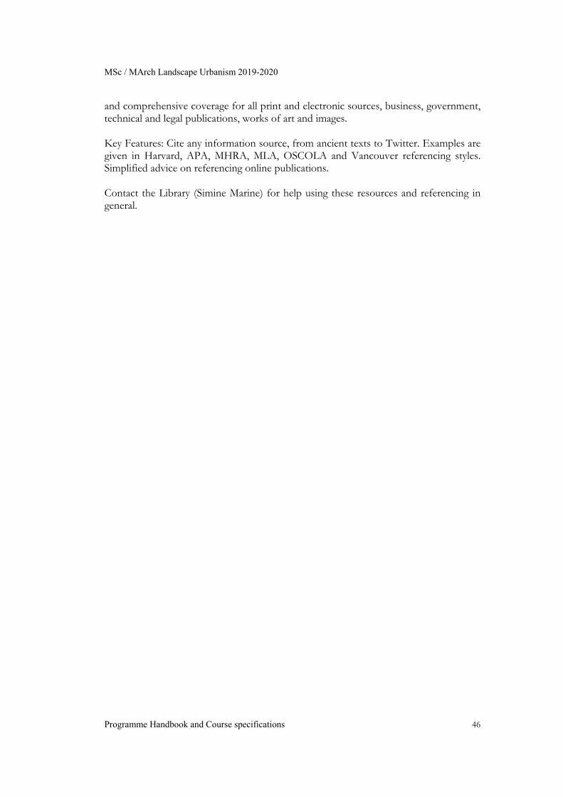
MSc / MArch Landscape Urbanism 2019-2020
Programme Handbook and Course specifications 46
and comprehensive coverage for all print and electronic sources, business, government, technical and legal publications, works of art and images. Key Features: Cite any information source, from ancient texts to Twitter. Examples are given in Harvard, APA, MHRA, MLA, OSCOLA and Vancouver referencing styles. Simplified advice on referencing online publications. Contact the Library (Simine Marine) for help using these resources and referencing in general.
MSc / MArch Landscape Urbanism 2019-2020
Programme Handbook and Course specifications 47
6.3 Submission and Resubmission Map Students are expected to comply with the following submissions dates as follows:
Students are expected to complete their submissions on time. In exceptional circumstances students can apply to the Programme Director for deferment of the submissions of a final project’s thesis to the following academic year. This can only be undertaken on one occasion. Below is the distribution of submissions in relation to partial and overall percentages of final award for the year 2015-16(see 3.2 section):
MSc / MArch Landscape Urbanism 2019-2020
Programme Handbook and Course specifications 48
7 RESOURCES There is a wide range of resources available to the students. The following list outlines the most relevant ones: Information resources in the School Library Computers and digital resources in the School’s Computer Lab Materials workshops and Digital Prototyping Lab Studio space The Landscape Urbanism programme’s dedicated website: http://landscapeurbanism.aaschool.ac.uk/ Contains each year’s Programme and Course Guideline, together with recent research work by graduates of the programme. The course also has active social network pages open to the students and thepublic as an interactive mechanism for communicating the work: Facebook (Galleries & News): AALandscapeUrbanism Twitter (News): AALandscapeUrb Instagram (Images): aalandscapeurbanism Issuu (Complete Design Thesis): http://issuu.com/aalandscapeurbanism 7.1 School Facilities Landscape Urbanism students are provided with their own studio space within Bedford Square premises, which is open every day from 8.00 a.m. – 10.00 p.m. Each student is provided with an individual desk space and facilities for connecting their computer to the AA internet and Server. Details of complementary facilities within the School as well as student support available within the AA are detailed in the AA School Academic Regulations document. 7.2 Programme Requirements Completion of a total of 180 credits (1,800 hours of study) by successful completion of the Phase 1 courses and successful submission of the Design Dissertation (MSc) or Design Thesis (MArch) in Phase 2. 7.3 Admissions
MSc / MArch Landscape Urbanism 2019-2020
Programme Handbook and Course specifications 49
The programme seeks to encourage a multidisciplinary intake and welcomes applications from those in the fields of architecture, engineering, landscape architecture, urbanism, as well as urban planning and geography or any other relevant field, provided that they meet the following entry requirements for admission to a graduate design programme: MSc Landscape Urbanism (12 months) Entry into the MSc Course is open to students with a professional degree or diploma in architecture, landscape architecture, urbanism, urban planning, geography, engineering or other relevant discipline. MArch Landscape Urbanism (16 months) Entry into the MArch Course is open to students with a five-year professional degree or diploma in architecture or a related discipline (BArch/Diploma equivalent). Reference Requirements Applicants must submit two references with the online application form: one related to work experience, the other academic. If the applicant has no work experience two academic references are required. References must be on headed paper and signed. No application will be considered before two references have been received.
MSc / MArch Landscape Urbanism 2019-2020
Programme Handbook and Course specifications 50
Portfolio Requirements All applicants are required to submit a portfolio of design work (no larger than A4 format) showing a combination of both academic and professional work (if applicable). CDs/DVDs of additional material are also accepted but only when accompanying a printed hard-copy portfolio. Portfolios must be accompanied by the completed Portfolio Cover Sheet (pdf). Portfolios will only be returned if requested and a £50 postage fee is paid in advance, or if the portfolio is picked up in person from the AA on a date prearranged with the Graduate Admissions Team. Language of study All courses will be taught in English. English language requirements To meet both the AA and the Home Office/UKVI English language requirements you will need to have one of the acceptable language qualifications listed in the AA School Academic Regulations, unless you are from one of the following groups:
You are a national of a majority English-speaking country as defined per the list on the UKVI website; or
You have successfully completed an academic qualification of at least three years’ duration, equivalent to a UK bachelor’s degree or above, which was taught in a majority English-speaking country as defined by the UKVI; or
You successfully completed a course in the UK as a Tier 4 (Child) student visa holder. The course must have lasted for at least six months, and must have ended no more than two years prior to your visa application.
If your place is conditional on providing English language qualification the following qualifications satisfy both the requirements of the Home Office/UKVI and the entry requirements of the AA:
IELTS (Academic) 6.5 overall with at least 6.0 in each category – two-year validity period: must be within the two years at time of CAS visa application.
Cambridge Certificate of Advanced English at grade C1 or C2.
Cambridge Certificate of Proficiency in English at grade C2.
Pearson Test of English (PTE) (Academic) overall minimum of 63 with a score of at least 59 in each category – two-year validity period: must be within the two years at time of CAS visa application.
Trinity College (Integrated Skills in English – ISE III / ISE IV) at grade C1 or C2.
Applicants are required to meet the scores in each category and overall – we cannot accept lower scores and we cannot combine test results across multiple score sheets. Applicants must submit their English language examination results by Friday 29 May
MSc / MArch Landscape Urbanism 2019-2020
Programme Handbook and Course specifications 51
2015, prior to entry in Term 1. The AA reserves the right to make a place in the school conditional on gaining a further English language qualification if deemed necessary. 7.4 Switching degrees Switching degrees within programmes operating a bifurcation model (MArch/MSc) will only be allowed under very exceptional circumstances. Students who feel strongly about it should approach the Course Directors before the end of the first week of Term 2. If they have compelling reasons for changing, they will be asked to submit a written statement by the last week of January on why they feel better suited for the other degree, how the potential change relates to the work they have done by then and what type of final work they envisage doing. This, together with the results of Term 1’s coursework, will be taken into consideration by the Course Directors and their teams when making the final decision. Students would have to fulfil the entry requirements of the degree they wish to switch to and under no circumstances can they change their visa arrangements. Refer to the AA Academic Regulation Document for more information: http://www.aaschool.ac.uk/downloads/studentDocuments2014/AA_School_Academic_Regulations_2014-2015.pdf .