Embed Size (px)
Citation preview
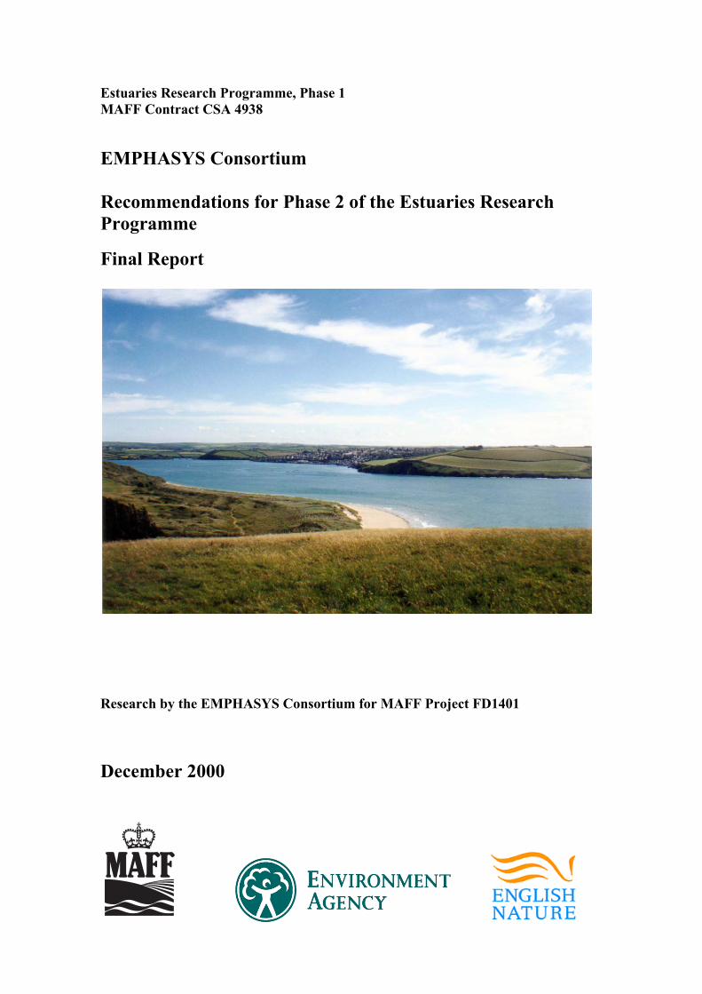
Estuaries Research Programme, Phase 1 MAFF Contract CSA 4938 EMPHASYS Consortium Recommendations for Phase 2 of the Estuaries Research Programme
Final Report
Research by the EMPHASYS Consortium for MAFF Project FD1401 December 2000


Estuaries Research Programme, Phase 1 MAFF Contract CSA 4938
Recommendations for Phase 2 of the Estuaries Research Programme
Final Report
Research by the EMPHASYS Consortium for MAFF Project FD1401
Report TR 113 December 2000 Prepared on behalf of the EMPHASYS Consortium by Professor Ken Pye Surface Processes and Modern Environments Research Group, Department of Geology, Royal Holloway and Bedford New College, University of London, Egham, Surrey TW20 0EX, UK Telephone / Fax +44(0)1784 443613 E-mail:[email protected] Web site: http://www.gl.rhul.ac.uk/SPME For further information on the Estuaries Research Programme Phase 1 visit the web site: http://www.hrwallingford.co.uk/projects/ERP/

ii TR 113 21/12/00

Contract This report describes work commissioned by the Ministry of Agriculture, Fisheries and Food, the Environment Agency (national R&D programme) and English Nature under MAFF Project FD1401 (Estuaries Research Programme, Phase 1). The Funders Nominated Project Officer was Peter Allen-Williams (MAFF). The HR Wallingford job number was ICS0030. The work was carried out by Professor K Pye and members of the EMPHASYS Consortium led by HR Wallingford. Publication implies no endorsement by the Funding Agencies of the conclusions or recommendations of the report. The report is a contribution to research generally and it would be imprudent for third parties to rely upon it in specific applications without checking its suitability. Every effort has been made to ensure that the statements made and the opinions expressed in this report provide a safe and accurate guide; however, no liability or responsibility of any kind is accepted in this respect by HR Wallingford Group Limited, and associated companies, the funders or the authors and their organisations. Prepared by .......................................................................................... (name) .......................................................................................... (Title) Approved by .......................................................................................... (name) .......................................................................................... (Title) Date ........................................... © Ministry of Agriculture, Fisheries and Food, Environment Agency and
Engligh Nature Copyright 2000
iii TR 113 21/12/00

iv TR 113 21/12/00
Members of the EMPHASYS Consortium HR Wallingford Ltd ABP Research & Consultancy Ltd Howbery Park Pathfinder House Wallingford Maritime Way Oxon OX10 8BA Southampton SO14 3AE Posford Duvivier University of Newcastle Rightwell House Department of Marine Sciences & Bretton Centre Coastal Management Peterborough Ridley Building PE3 8DW Newcastle Upon Tyne NE1 7RU Royal Holloway University of London Proudman Oceanographic Laboratory Department of Geology Bidston Observatory Queens Building Birkenhead Egham Merseyside Surrey TW20 0EX L43 7RA WL | Delft Hydraulics Plymouth Marine Laboratory Marine & Coastal Management Division Prospect Place P.O. Box 177 West Hoe 2600 MH Delft Plymouth PL1 3DH The Netherlands British Geological Survey School of Ocean and Earth Sciences Kingsley Dunham Centre University of Southampton Keyworth European Way Nottingham NG12 5GG Southampton SO14 3ZH Centre for Ecology and Hydrology Dorset CEFAS Winfrith Technology Centre Lowestoft Laboratory Newburgh Road Pakefield Road Dorchester Lowestoft Dorset DT2 8ZD Suffolk NR33 0HT Professor K.R. Dyer Norton Hayes Bradford-on-Tone Taunton Somerset TA4 1HP
v TR 113 21/12/00

vi TR 113 21/12/00
Contents Title page i Contract iii Members of the EMPHASYS Consortium v Contents vii Executive Summary ix
1. Introduction ................................................................................................ 1
2. Review of recent and current estuarine research ........................................ 5 2.1 The UK.......................................................................................... 5 2.2 Rest of the World........................................................................... 7 2.3 Summary of modelling results from Phase 1................................. 7
3. Requirements for future data collection, monitoring and research............. 9 3.1 Data and monitoring ...................................................................... 9 3.2 Model development ..................................................................... 11
3.2.1 General ........................................................................... 11 3.2.2 Morphology .................................................................... 11 3.2.3 Hydrodynamic processes................................................ 12 3.2.4 Sediments and sediment processes................................. 12 3.2.5 Ecology and water/sediment quality .............................. 13 3.2.6 Anthropogenic aspects ................................................... 13
3.3 Basic research.............................................................................. 13 3.3.1 Morphology .................................................................... 13 3.3.2 Hydrodynamics .............................................................. 14 3.3.3 Sediments ....................................................................... 14 3.3.4 Ecology and water / sediment quality ............................ 14 3.3.5 Anthropogenic / management aspects ............................ 14
4. Conclusions and recommendations .......................................................... 15 4.1 Phase 2 objectives........................................................................ 15 4.2 Basic research requirements ........................................................ 15 4.3 Data collection and monitoring requirements ............................. 15 4.4 Phase 2 study areas...................................................................... 16 4.5 Phase 2 implementation............................................................... 16 4.6 Summary ..................................................................................... 17
5. References ................................................................................................ 18 Tables Table 1 Relationships between main estuary user interests and estuary
attributes............................................................................................... 1 Appendices Appendix 1: Extract from Report SR478: The Case for Research into Estuarine
Morphology and Processes Appendix 2: Summary of Discussions held during the Mid-Term Workshop, 4-5
October 1999 Appendix 3: Summaries of recent and current research compiled from the world-
wide web and other sources
vii TR 113 21/12/00

Contents continued Appendix 4: Summaries of ongoing and imminent research collated by the
Funders’ representatives in the Estuaries Advisory Group Appendix 5: Summaries of estuarine research programmes in Australia, USA and
the Netherlands presented by overseas delegates to the Mid-Term Workshop
Appendix 6: Classification of EMPHASYS Consortium Phase 2 Research Recommendations into the MAFF/EA FCD research themes
viii TR 113 21/12/00

Executive Summary Estuaries Research Programme, Phase 1 MAFF Contract CSA 4938 Recommendations for Phase 2 of the Estuaries Research Programme Research by the EMPHASYS Consortium for MAFF Project FD1401 Final Report Report TR113 December 2000 The morphology of an estuary (its shape and underwater contours) affects, and is in turn affected by, issues relating to flood defence, water quality, conservation and navigation. Companion reports1 to the present report provide answers to some of the key questions that face those concerned with such issues: estuary managers, stakeholders and interest groups. The reports result from Phase 1 of the UK Estuaries Research Programme undertaken by the EMPHASYS2 consortium, which comprises 13 partners including practitioners and researchers with widely varying and complementary areas of expertise. Links are made between the understanding and prediction of changes in estuarine morphology and the resulting changes in the ecology and water quality that are subject to legislative constraints, policy and directives. The key concerns for estuary managers, stake-holders and interest groups are usually triggered by a plan to make some change to the estuary they have an interest in – a proposed project such as a construction, intervention or development that would alter the status quo. If they are the organisation planning to make the change they will have questions like: • Will the project achieve what is intended? • What is the most effective and economical design for the project? • Will the project fall within current legislation, policies and directives? • Will it be acceptable to other stakeholders, or will it be blocked by public
pressure? If they are not the ones making the change, they will have questions like: • How will this affect public safety (e.g. flooding of populated areas)? • How will it affect other commercial concerns (e.g. shell-fisheries, tourism)? • How will it affect the environment, ecology and habitats? • Will a localised project have undesirable impacts further afield? Even in the absence of such an intervention, questions can be raised such as: • How “healthy” is this estuary? 1 Reports (listed in the Bibliography below) on: Guide to Prediction of Morphological Change, Legislative Context, Directory of Predictive Methods, Modelling Report, and Database 2 Estuarine Morphology and Processes Holistic Assessment SYStem
ix TR 113 21/12/00
Executive Summary continued Phase 1 of the Estuaries Research Programme had two main objectives: (a) to perform research in order to provide tools to help answer these kinds of
questions (b) to make recommendations for the most effective programme of research to be
undertaken in Phase 2 of the Research Programme to provide better tools for the future.
This report deals with the latter of these. The second objective was divided into three sub-components: 1. to make recommendations for future data collections and sites 2. to establish a research framework for the development of improved prediction
methods 3. to identify Basic Research areas into new technologies and improved
modelling techniques. The funding of sub-components 1 and 2 is seen as lying with the funders of Phase 1 of the Programme, namely MAFF, the Environment Agency, and English Nature. The funding of sub-component 3 is seen as lying primarily with the Research Councils (mainly NERC and EPSRC). The report re-states the case for research put forward in 1997 in a Scoping Study report, reviews existing research, offers recommendations for future research under the three headings given above, and discusses possible implementation strategies. The conclusions of the Scoping Study are found to be largely still valid: while Phase 1 was primarily concerned with drawing together and structuring existing data, models and methods, Phase 2 will be more concerned with innovative research. The Study recommended a number of options for Phase 2 with cost ranging from £1.6M to £5.1M and duration ranging from 3 to 5 years. To stay in harmony with Phase 1, the present report recommends that a programme in the middle of the range of options is most appropriate, having a cost somewhere between £2M and £4M and a duration of 4 to 5 years. The review of existing research covers Europe and the rest of the world to some extent, as well as the UK. The detailed topics of recommended research were derived from consortium members, from members of the Estuaries Advisory Group, and from external users and researchers. The external inputs were largely provided during the Mid-term Workshop of the Phase 1 project in October 1999, and have been supplemented by other individual inputs since then. The topics are grouped under logical linked thematic headings. A number of implementation possibilities are put forward, ranging from a larger number of individually undertaken research projects, to a single large consortium as was appropriate for Phase 1. The option thought to be most appropriate to the rather different nature of Phase 2 is a number of mini-consortia, each comprising about two to four research organisations with complementary skills. These would each undertake a research project appropriate to their skill-base, which combines
x TR 113 21/12/00
Executive Summary continued three to four inter-linked, and possibly inter-disciplinary, research topics. An overall co-ordination project to link the various research projects together would be an essential element of such a programme. The flood and coastal defence aspects of the research funded by MAFF and the Environment Agency are currently being organised into six themes. Accordingly, the listed research topics have each been assigned to one of these themes. Most of them fall under either the Processes theme or the Broad-scale Modelling theme. Some of the topics that are relevant to aspects of estuarine management other than flood and coastal defence fall outside the six themes, and will need to be funded through other functions. The recommendations in this report put forward a coherent, forward-looking and user-orientated programme of research for Phase 2, to build on the solid foundation laid down in Phase 1. PROJECT BIBLIOGRAPHY OF OTHER KEY REPORTS
EMPHASYS Consortium (2000). A Guide to Prediction of Morphological Change within Estuarine Systems. Version 1B. Research by the EMPHASYS Consortium for MAFF Project FD 1401. Report TR 114. HR Wallingford, UK. December 2000. Posford Duvivier Environment. 2000. Legislative Report. Research by the EMPHASYS Consortium for MAFF Project FD 1401. March 2000. Posford Duvivier. 2000. The Estuaries Research Programme, Phase 1A - Predictive Methods Report. Research by the EMPHASYS Consortium for MAFF project FD1401. March 2000. EMPHASYS Consortium (2000). Modelling Estuary Morphology and Process. Final Report. Research by the EMPHASYS Consortium for MAFF Project FD 1401. Report TR 111. HR Wallingford, UK. December 2000. ABP Research and Consultancy Ltd. The Estuaries Research Programme, Phase 1- Databases. Research by the EMPHASYS Consortium for MAFF Project FD 1401. Report No. R.848 and CD-ROM. November 1999.
xi TR 113 21/12/00

xii TR 113 21/12/00
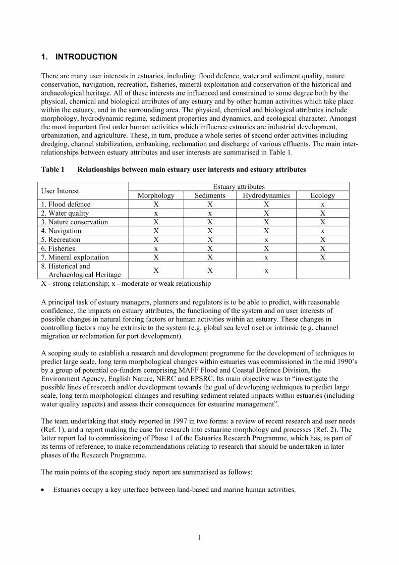
1. INTRODUCTION There are many user interests in estuaries, including: flood defence, water and sediment quality, nature conservation, navigation, recreation, fisheries, mineral exploitation and conservation of the historical and archaeological heritage. All of these interests are influenced and constrained to some degree both by the physical, chemical and biological attributes of any estuary and by other human activities which take place within the estuary, and in the surrounding area. The physical, chemical and biological attributes include morphology, hydrodynamic regime, sediment properties and dynamics, and ecological character. Amongst the most important first order human activities which influence estuaries are industrial development, urbanization, and agriculture. These, in turn, produce a whole series of second order activities including dredging, channel stabilization, embanking, reclamation and discharge of various effluents. The main inter-relationships between estuary attributes and user interests are summarised in Table 1. Table 1 Relationships between main estuary user interests and estuary attributes
Estuary attributes User Interest Morphology Sediments Hydrodynamics Ecology 1. Flood defence X X X x 2. Water quality x x X X 3. Nature conservation X X X X 4. Navigation X X X x 5. Recreation X X x X 6. Fisheries x X X X 7. Mineral exploitation X X x X 8. Historical and Archaeological Heritage X X x
X - strong relationship; x - moderate or weak relationship A principal task of estuary managers, planners and regulators is to be able to predict, with reasonable confidence, the impacts on estuary attributes, the functioning of the system and on user interests of possible changes in natural forcing factors or human activities within an estuary. These changes in controlling factors may be extrinsic to the system (e.g. global sea level rise) or intrinsic (e.g. channel migration or reclamation for port development). A scoping study to establish a research and development programme for the development of techniques to predict large scale, long term morphological changes within estuaries was commissioned in the mid 1990’s by a group of potential co-funders comprising MAFF Flood and Coastal Defence Division, the Environment Agency, English Nature, NERC and EPSRC. Its main objective was to “investigate the possible lines of research and/or development towards the goal of developing techniques to predict large scale, long term morphological changes and resulting sediment related impacts within estuaries (including water quality aspects) and assess their consequences for estuarine management”. The team undertaking that study reported in 1997 in two forms: a review of recent research and user needs (Ref. 1), and a report making the case for research into estuarine morphology and processes (Ref. 2). The latter report led to commissioning of Phase 1 of the Estuaries Research Programme, which has, as part of its terms of reference, to make recommendations relating to research that should be undertaken in later phases of the Research Programme. The main points of the scoping study report are summarised as follows:
Estuaries occupy a key interface between land-based and marine human activities. •
1
They are a very important resource in terms of transport, industry, commerce, settlement, fishing, agriculture, habitat and recreation.
•
•
•
•
•
•
•
•
• •
•
•
•
•
•
They pose conflicting problems in terms of flood defence, navigation, water quality and nature conservation. Management of estuaries should be undertaken in a way that takes account of all these issues in concert. Such management is hampered by the lack of well-validated and accepted prediction tools.
The justification for a programme of research to rectify this position was evaluated, demonstrating that such research would be amply justified for the following reasons:
The economic importance of estuaries can be quantified in terms both of direct and intangible benefits; the benefit / cost ratios for the research were estimated to be between 3 and 6. The scientific justification concluded that the research programme was an exceptionally challenging task for scientists and engineers from a wide range of disciplines, which would deliver improved scientific knowledge and techniques in the fields of hydrodynamic, sedimentary, chemical and ecological processes. The programme would additionally lead to the development of a national inter-disciplinary research network, contribute to the training of young scientists and engineers, and develop an enhanced skills base to sell UK estuarine expertise overseas.
The programme was seen to be timely, because legislation, industrial and infrastructural development, the accumulation of past impacts and climatic change are all conspiring now to put unprecedented pressure on our estuaries The solutions proposed in the scoping study were:
A three-phase research project lasting between 9 and 12 years, and funded to a level of £7 -£18M (at 1997 prices). Phase 1 to comprise testing and comparison of existing prediction methods against existing data. Phase 2 to comprise the improvement and combination of the best methods, together with new fundamental research. Phase 3 to comprise the development of new, cross-fertilized methods based on the results of the fundamental research from Phase 2. Phase 1 to be largely concerned with the physical, chemical, biological and geological aspects of estuaries, while Phase 2 and 3 increasingly include socio-economic aspects. An Estuarine Impact Assessment System, in the form of a report for use by estuary managers, to be delivered at the end of Phase 1 based on existing methods; this to be updated at the end of Phase 2 to include the newly developed methods, and updated again at the end of Phase 3 to include socio-economic factors to become an Estuarine Management System. A range of options offered to allow a trade off of the time, cost, and quality / confidence of the products, to be chosen for each phase; realignment and refunding possible between phases. More fundamental elements of the research to be funded mainly by the research councils and the more practical-oriented elements to be funded by MAFF, the Environment Agency and English Nature.
Further details and quantification are given in Appendix 1, in which a major part of the Scoping Study Report is reproduced. The position regarding the justification for further research has changed little since 1997. Indeed, recent changes have further underlined the fact that, to comply with UK Government and European legislative directives, and to attain environmental quality goals such as those set out in the Environment Agency's strategy for the 21st century (Ref. 3), estuary users and managers require a range of practical tools which can be used to look both at the interactions between individual elements of an estuarine system and at the
2

functioning of the system as a whole. For practical purposes, some of the tools need to be capable of making reliable predictions at least 50 years ahead. The Report of the MAFF Advisory Committee on Flood and Coastal Defence Research and Development (Ref. 4) identified that there is an important need for further research into fluvial, estuarine and coastal processes in order to better inform policy decisions, and in particular to facilitate development of management tools. The Committee concluded that: "Although some progress towards the development of such tools can be made using existing scientific knowledge, it is clear that significant advances in the understanding and prediction of various estuary processes are required". The Committee's recommendation for a Thematic Topic in this area has been accepted in the MAFF and Environment Agency's proposals for the implementation of the recommendations (Ref.5). Building upon the first 18 months in to Phase 1 of the Estuaries Research Programme, there is a need to plan the research content of Phase 2, taking on board external views and the experience of Phase 1. As required by the terms of reference, this report identifies and prioritises topics for further research under the headings of:
data collection methods and sites • •
•
a research framework for the development of improved prediction methods and model development, based on the experience of the techniques examined in Phase 1 which show most potential 'blue skies' (basic) research areas which should feed into the later stages of Phase 2 and Phase 3 of the programme.
The report has gathered information from a number of sources: • A critical and updated review of recent and current research, both in the UK and overseas. • Views from members of the research consortium in the light of work being done in Phase 1. • Views submitted by users and external researchers, including members of the EAG, and particularly
as stimulated by the Mid-Term Workshop of the project in October 1999. • Views collated during rotating discussion sessions on Flood Defence, Navigation, Water Quality and
Conservation at the Mid-Term Workshop, reports on which are included as Appendix 2 of this report.
• Summaries of ongoing and imminent research collated by the Funders’ representatives in the EAG, included in Appendix 4 of this report.
• Summaries of estuarine research in other countries, presented by the overseas delegates to the Mid-Term Workshop, included as Appendix 5 of this report.
A summary of the main techniques currently available for the modelling of estuarine processes, morphological change and associated effects on ecology and water quality, including those being tested in Phase 1 of the Estuaries Research Programme, is provided in a separate report (Ref. 6). This report provides a discussion of model strengths, limitations and opportunities, as perceived at the end of Phase 1A. For the purposes of evaluation, models have been classified into three types, referred to as 'bottom-up', 'top-down' and 'hybrid'. Bottom-up models are essentially based on numerical solutions of differential equations which represent physical processes in a simplified form. Although such models have become progressively more sophisticated and complex as computing power has increased in recent years, there are inherent limits to the temporal scales over which reliable predictions can be made. 'Top-down' models essentially examine the relationships between broad scale attributes of a system or systems in order to establish 'general rules' or longer term statistical trends. They are more applicable to prediction of long-term change than bottom up models but cannot predict shorter term changes with the same level of detail. Hybrid models may be regarded essentially as top-down methods which are calibrated at intervals of time or in a probabilistic manner using outputs from one or more bottom-up methods. It will not be fully clear until the end of Phase 1B which specific methods offer the most promise for further development, and only preliminary recommendations can be made at this stage. However, the importance of further investigation
3

into the linkages between different models, and between morphology, sediments, ecology and water quality, is already apparent. Further work in Phase 2 should also take advantage of opportunities to exploit innovative and exciting new areas of science applicable to estuaries, as well as addressing specific user needs. In Section 4.5 (and Appendix 6) the Recommendations are classified in terms of the current MAFF/EA Flood and Coastal Defence research themes.
4

2. REVIEW OF RECENT AND CURRENT ESTUARINE RESEARCH
2.1 The UK Estuarine research and data collection in the UK over the past 10 years has been funded by a wide range of organizations including the Research Councils (especially NERC and EPSRC), MAFF, DETR, The Environment Agency, Welsh Office, Crown Estates, Scottish Office, English Nature, Joint Nature Conservation Committee, Local Authorities, Private Industry, Charitable Trusts and The European Commission. The summary of recent and current research provided below is not intended to be exhaustive but aims to identify the major existing activities which have relevance to the future development of the Estuaries Research Programme. NERC currently funds or part-funds a fairly limited amount of estuarine research through thematic programmes and responsive mode awards involving the NERC Institutes, British Geological Survey and Universities. Most of this support is provided through the Marine Science and Technology Board. Recent and current initiatives with significant estuarine components include: Integrated Modelling phase of the Land Ocean Interaction Study (LOIS) Aims: To develop integrative explanatory and predictive models using data obtained during the main LOIS Community Research Programme which ran between 1994 and March 2000. This initiative involves several NERC Institutes, The British Geological Survey and a number of universities. This programme is limited in scope and there are no immediate plans for a large scale extension of the work. Restricted Exchange Environments (REEs) The main aims of this Core Strategic project are to improve understanding of marine restricted exchange environments (sea lochs, saline lagoons, estuaries, creeks, embayments), their interactions with coastal waters, underlying characteristics and vulnerability to anthropogenic perturbations and forcing functions (e.g. eutrophication, sea level rise, storm erosion, mobilization of contaminated sediments). The planned duration is 5 years (1999-2004). Chiefly involved are the Plymouth Marine Laboratory (PML) and Dunstaffnage Marine Laboratory (DML) elements of the NERC Centre for Coastal and Marine Sciences (CCMS). REEs activities in 2000 include planned collection of seasonal synoptic field data sets (hydrodynamics, nutrients, suspended sediments) in the Tamar estuary. Existing data from the LOIS and earlier programmes are also being used to test and refine models. Integrating Marine Pollution, Transport, Reactivity & Toxicity for Risk Assessment-(IMPACT) This CCMS Core Strategic project, directed from PML but also involving POL, is concerned principally with the distribution, mobilization, interactive behaviour and significance of contaminants in estuaries and coastal shelf seas. The principal geographical focus to date has been the Humber estuary. A field data collection campaign in the Mersey is currently proposed for 2001. Coastal and Estuarine Evolution Project (British Geological Survey Core Project) The principal aim of this project is to examine the Holocene evolution of the UK coastal zone over a variety of time scales, from decades to millennia, in order to better understand the long-term processes which drive coastal evolution and to deliver geoscientific knowledge and data to enhance the prediction of the future response of the coast to various scenarios of environmental change. Initial work will collate existing results for Humber estuary, Wash and the Fens, and commence compilation of data for Irish Sea estuaries (notably the Mersey). Subsequent stages will focus on SE Scotland, the South Coast of England and Thames estuary. Planned deliverables will include a British Estuaries Report Series and a Coastal Change Map Series. Duration 5 years; managed by the Coastal and Engineering Geology Section of the BGS. The NERC Institute for Terrestrial Ecology (ITE), more recently the Centre for Ecology and Hydrology, has a number of important research initiatives relating to biota in estuaries (notably at Furzebrook and Monkswood Research Stations). This work is supported by a combination of NERC Core funding,
5
European Commission contracts, and industrial commissions. The Earth Systems Science Centre (ESSC) at Reading University is also involved in the development of methodologies (largely remote sensing based) which can be applied to monitoring of change in estuarine and coastal environments. NERC currently provides limited support for estuarine research in universities through studentships and responsive mode research grants. Most of the research supported at present (through two grants and six studentships) is biological or geochemical in nature (e.g. concerned with emission of trace gases, behaviour of trace metals, biomass and biodiversity). EPSRC currently has no thematic programmes focussed exclusively on estuaries and coasts although several projects relating to estuarine processes and engineering are supported under the general heading of Coastal and Waterway Engineering. Estuarine topics with current support include Assessing the Sustainability of Estuarine Impoundments, Hydrodynamics and Mixing of Estuarine Inlets and Influence of Tidal Barriers, The Influence of Biota on Silt Dynamics Following Dredging Activities, and Modelling Compliance of Estuarine Waters. Several projects relating mainly to the open coast and rivers also have relevance to estuaries. The combined value of current research grants in Coastal and Waterway Engineering is c. £7.6M, of which c. £1.2M relates directly to estuaries. In 1998/9, the Flood and Coastal Defence with Emergencies Division of MAFF spent c. £2.1M on strategic research for flood and coastal defence (c. £2.5M in 1997/8). Five projects were supported in 1998/9 under the heading of Estuarine Flood Defence (Ref. 7), three of which are still in progress (including the Estuaries Research Programme). Other current work relates to the management and monitoring of the Tollesbury experimental managed realignment site. Additional research relevant to estuaries is included the headings of Cross-Cutting Fluvial Flood Defence and Tidal Flood Forecasting. A large proportion of the estuary-related research (other than the Estuaries Research Programme) supported by the Environment Agency at National level has been managed by the Saltmarsh Steering Group. Current and recently completed projects include The Restoration of Vegetation on Saltmarshes, Pollution of Managed Realignment, Saltmarsh Sedimentation Processes, Sedimentation Tracer Studies: Medway Phase I, Beneficial Use of Dredged Sediment Phase I. Planned / proposed projects include Wave Attenuation over Saltmarshes, Holistic Whole Estuary Cost-benefit, Audit of Saltmarsh Resources in the UK and Monitoring Foreshore Recharge Works. In addition, both strategic and scheme-specific investigations and monitoring have been commissioned at Regional level (some jointly with other organizations). Work of this type includes the Humber ESMP and GEO II studies, the Suffolk Estuarine Strategies, Welland Siltation Study, River Great Ouse Siltation Study, Teifi Estuary Study, and various other Estuary Management Plans. The research element in these studies has been variable, and in general supported research has been closely related to end user needs rather than being fundamental in character. A considerable amount of background monitoring data is regularly collected through Regional and Local offices of the Agency, and by the National Centre for Environmental Data and Surveillance. A certain amount of this data has been analyzed and interpreted for research and operations purposes, but considerable scope exists to make greater use of the information collected. A significant amount of additional research is being undertaken by universities and commercial research organizations with funding from UK industry, nature conservation bodies and charities (including Port Authorities, Water Companies, English Nature, RSPB, Leverhulme Trust etc.). In the main, that research supported by Charities and Universities themselves is principally fundamental in character, while that supported by industry is strategic or applied. Several UK universities are/have been concerned with research into estuarine morphology, processes and historical change, including London (UCL, Imperial College and Royal Holloway), Cambridge, Newcastle, Southampton, Reading, Durham, Plymouth, Bangor, Liverpool, Cardiff and Stirling.
6
2.2 Rest of the World A substantial amount of research on the basic physical properties of estuarine sediments, sediment transport processes and interactions with sediment biota was undertaken under the European MAST III Programme (1994-8), notably the INTRMUD (The Morphological Development of Intertidal Mudflats) and COSINUS (Prediction of Cohesive Sediment Transport and Dynamics in Estuaries and Coastal Zones with Integrated Numerical Simulation Models) projects. Outputs from these MAST III projects will continue in 2000. Other relevant European funded research include the ISLED (Impact Rising Sea level Rise on Ecosystem Dynamics of Saltmarshes) and ECOFLAT projects, coordinated by the Netherlands Institute of Ecology. Further research opportunities related to socio-economic and management aspects of estuaries may arise under the Fifth Framework Programme (1999-2004). Outside Europe, significant research relating to estuaries is being undertaken in several countries, including the United States, Canada, Australia, New Zealand and China (details are given in Appendix 3). The objectives of this research vary widely, from the generic to the quite specific. As in the UK, much of this research falls into a number of distinct categories, dealing mainly with: (i)
(ii)
(iii)
(iv)
(v)
(vi)
(vii)
the long-term evolution (geologically speaking) of estuaries, on timescales of decades to millennia, involving geological, palaeoecological and geoarchaeological approaches.
medium term geomorphological responses to changes in environmental forcing factors (sea level fluctuations, tidal range changes, wind/wave climate fluctuations) and human activities (dredging, reclamation, port development).
development of engineering solutions to specific problems (e.g. flood defence, siltation and navigation).
studies of short-term hydrodynamics, sediment dynamics and water quality, including nutrient fluxes and effects on the biological functioning of estuaries.
applied studies such as water quality modelling related to environmental management (sewage and industrial effluent dispersion etc).
essentially ecological studies concerned with invertebrates, birds, fish etc.
studies related to habitat recreation, restoration and enhancement.
Within North America, significant programmes of estuarine research are supported by the US Army Corps of Engineers, the Environmental Protection Agency (EPA), and the National Oceanographic and Atmospheric Administration (NOAA). Summaries of selected estuary-related research activity being undertaken in the USA and Australia are included in Appendix 5 of this report. Most estuary research outside the UK is being undertaken by small groups and individuals. Relatively little progress has so far been made towards the development of working hybrid models or the integration of processes, morphology, ecology and water quality within the context of the human use and management of estuaries. Many of the outstanding gaps identified in UK research also exist elsewhere, and no country has yet developed an all-embracing hybrid estuarine 'model' or 'assessment system' which could meet user requirements within the UK.
2.3 Summary of modelling results from Phase 1 The EMPHASYS consortium has documented (Ref. 6) available methods for predicting estuary morphology and process and has performed a large number of tests of 15 models and methods against six key representative estuaries (Ref. 8).
7

The research has shown that no one model and no one approach will provide adequate prediction of morphological evolution in estuaries, all the methods have strengths and limitations. Though it has been beneficial to distinguish between Bottom-up, Top-down and Hybrid methods, future development is likely to combine the methods as required for specific tasks. It will be necessary, therefore, to relax the boundaries between the groupings and only to consider the methods to be more conceptual or more analytical. The problems of model application across space and time remain at the end of this phase of the research. Wide scale application across a range of estuarine environments is here perhaps less of a problem for bottom-up simulation than the problem of long-term prediction and the major issue of feedback.
8

3. REQUIREMENTS FOR FUTURE DATA COLLECTION, MONITORING AND RESEARCH
3.1 Data and monitoring The process of data evaluation and synthesis undertaken in Phase 1A of the Estuaries Research Programme highlighted the fact that in many UK estuaries there is a serious lack of basic information relating to bathymetry / topography, hydrodynamic processes, sedimentary characteristics (particle size distribution, mineral and chemical composition), contamination status (water quality and sediment quality) and ecological importance (e.g. infaunal populations and dynamics). Specific limitations include: (i)
(ii)
(iii)
(iv)
at present only limited field data sets exist against which to validate methods for prediction of long term morphological change
only a few UK estuaries have estuary wide bathymetric data sets which span the intertidal areas, and even fewer estuaries have complete data for several synoptic surveys at different dates; this provides a serious constraint both for short-term ‘bottom-up’ modelling / model validation and for top-down and hybrid modelling approaches.
there are few long term records of tides, currents, waves, suspended and bedload sediment movements in UK estuaries; coverage is spatially and temporally discontinuous and very variable in terms of quality.
the accuracy of any validated predictive technique is only as good as the data available for validation; where only limited data exists the accuracy of the technique must be questionable.
There is a clear need to obtain new closely coupled field measurement data, relating synoptic hydrodynamic processes, sediment transport processes, morphology, water quality and biota, in order to provide new quantitative relationships which will provide the basis for the new predictive models in Phases 2 and 3 of the Estuaries Research Programme. In addition, identification and quantification of any future changes in UK estuaries, however caused, will require adequate baseline studies and subsequent monitoring in a much more systematic way than has been carried out to date. A comprehensive national estuarine monitoring programme is outside the scope of Phase 2 of the Estuaries Research Programme as outlined in the Scoping Study. The specific requirements for further data collection in Phase 2 will depend very largely on the nature of the models and approaches which are judged worthy of further development following the model testing in Phase 1B. The requirements will vary from model to model, and a decision will need to be made whether to concentrate data collection on a single estuary, on some or all of the six estuaries selected for study in Phase 1B, or on a wider choice of locations. Whatever the number of estuaries to be ultimately chosen, it is likely that the priorities will be as follows, in order of perceived priority: (i) more accurate, spatially complete, synoptic bathymetric surveys (including topography in inter-tidal,
supratidal and extra-tidal estuary environments); adequate baseline surveys are an essential requirement for assessment of change. This is likely to require combined hydrographic, LIDAR and possibly ground-based GPS surveys in the selected estuaries, leading to development of composite digital terrain models.
(ii) sequential surveys are likely to be required for rigorous testing of the ability of models to predict change; the spatial scale and temporal frequency required will vary depending on the model being tested, and may range from weekly surveys of localized areas to annual surveys of whole estuaries.
9
(iii) although some existing data sets can used for further analysis, there will be some requirement for new time series data for water levels, winds, waves, suspended sediment concentrations, bedload movements, salinity, and current velocities to provide reliable input data to drive and test specific models, and for development of statistical interrogation methods.
(iv) spatial and temporal information about sediment characteristics will be required, including
geotechnical and biological properties which determine erodibility, instability, and morphological sensitivity and which have a bearing on biodiversity and water quality.
(v) information about the age structure of the sediments in the selected estuaries will be required to
calculate long-term sedimentation rates and patterns of erosion / accretion; this should be addressed by a programme of shallow coring and sediment dating using a combination of geochemical, radiometric, palaeo-ecological and archaeological evidence.
(vi) complete inventories of contaminants ‘locked’ up in estuarine sediments, effects on water quality if
released back into the water column. (vii) information about sediment and pore water chemistry, including diagenetic regime is needed to test
model predictions of bio-geochemical fluxes and effects of sediment remobilization on water quality and biota.
(viii) synoptic physical / chemical / biological short term data sets which allow linkages and feedbacks to
be examined / predictions to be tested (e.g. between intertidal flat morphology, sediment character, infaunal population density, and numbers of feeding birds).
(ix) surveys are also needed in many estuaries to quantify the human and economic interest, the extent
and ‘value’ of different habitat types, and sites of archaeological / historical interest, if coupled physico-ecological or physico-economic models are to be tested and applied.
For new surveys, special attention should be given to determining the limits of the area(s) to be surveyed and the timescales for repeat surveys; understanding of process will be important in this respect. New surveys should also make maximum use of recent developments in survey methodology (e.g. LIDAR, kinematic GPS, CASI, digital air photography and videography, ADCP). Digital elevation models (DEM's) should be prepared for all estuaries and adjoining areas. Efforts should be made to ensure that all new data are stored in formats which facilitate ready transfer between collectors, researchers and end users. Access to data should be improved by the provision of better metadata systems. Mechanisms for such provision have recently been explored in the EC THETIS project (Ref. 9) and the CIRIA supported Maximizing the Use and Exchange of Coastal Data project (Refs. 10 & 11). There are strong arguments that further work in Phase 2 should continue to focus on all or some of the six estuaries selected for study in Phase 1. Such a strategy would make maximum use of the results already generated; in addition, several of these estuaries have substantial existing databases from previous projects or are the subject of planned future initiatives. These six estuaries are: Blackwater, Humber, Mersey, Ribble, Southampton Water and Tamar.
10

3.2 Model development
3.2.1 General Research in Phase 1 (Ref. 8) has shown that no one model and no one approach will provide adequate prediction of morphological evolution in estuaries, all the methods have strengths and limitations. Hence, the best practical way forward for management purposes is to employ a combination of approaches which have been demonstrated to be ‘credible’. For the purposes of prioritization, a distinction can be drawn between models and research areas which apply mainly to smaller spatial scales and shorter timescales and those which relate mainly to longer timescales and larger spatial scales. These two types of model / approach are quite different in character and are more appropriately judged according to separate schemes of prioritization.
3.2.2 Morphology A fundamental objective of the Estuaries Research Programme is to develop improved models which can predict the morphological responses of estuaries to changes in forcing factors (both natural and anthropogenic) on medium to longer time scales (up to 50 or 100 years), and the ways in which morphological changes affect other estuarine properties (hydrodynamics, water quality, biodiversity, human resource value). In order to achieve more accurate and reliable morphological prediction, development of existing bottom-up, top-down and hybrid models is required, as well as basic new research. Specific areas / models which require further short-term research and development include: (a) Large scale / long term (i) the influence of geological constraints on estuary shape and the sensitivity of estuaries to changes in
forcing factors (i.e. rate and magnitude of morphological response). (ii) concepts of equilibrium shape (three-dimensional as well as two-dimensional), including
quantification of hydraulic geometry and energy regime relationships; application to prediction of effects of land reclamation, dredging and managed realignment.
(iii) more comprehensive and rigorous prediction of the response of estuaries to changes such as sea
level, tidal regime, wave energy and sediment supply, under constrained and unconstrained conditions (including refined rollover and accommodation space models).
(iv) further formalization of procedures for historical trend analysis (HTA) and expert geomorphological
assessment (EGA) as top down and hybrid approaches. (b) Local to medium scale, short to medium term (i) coupling of whole estuary models with more detailed models of individual estuarine components
(e.g. saltmarshes or mudflats) to produce refined hybrid morphological models; a single framework hybrid model, into which top-down and bottom-up models can be slotted, is a desirable but possibly unattainable objective at least within the very near future.
(ii) more effective representation of linkages between sediment properties and biological factors in
morphological models. (iii) more realistic representation of inter-tidal environments and processes in whole estuary
morphological models.
11

(iv) refinement and testing of quantitative relationships between morphology, sediment properties and hydrodynamic regime (e.g. Stability Factor Analysis).
3.2.3 Hydrodynamic processes Specific areas for model development include: (a) Short to medium term (i) more realistic modelling of wave generation, propagation and dissipation in estuaries and near-shore
approaches, incorporating shallow water effects, internally-generated waves and wave-current interactions.
(ii) effects of changes in estuarine morphology and tidal prism on local and non-local hydrodynamic and
sediment transport processes. (iii) methods of predicting the effects of short-term extreme, and longer-term average, changes in fluvial
discharge, groundwater flow and tidal regime on salinity distribution and water / sediment circulation patterns; interfacing of existing tidal flow, freshwater flow and groundwater flow models.
(iv) prediction of tidal processes within estuaries with complex/ irregular morphology, especially
discharge and velocity asymmetry in the higher intertidal zone and areas with complex channel systems.
(v) more realistic representation of near-bed stresses due to waves and currents, and how these are
influenced by the presence of mobile sediment (i.e. in suspension or as bed load). (vi) modelling of turbulence and turbulent mixing, especially in combined wave current regimes and
with mobile sediments.
3.2.4 Sediments and sediment processes (a) Large scale, medium to long term (i) prediction of surface and sub-surface sediment properties using remote sensing. (ii) use of sediment properties (e.g. grain size trends) to predict net sediment transport paths, erosion /
accretion trends and morphological changes. (iii) refinement and application of sediment fingerprinting and tracer techniques to define sediment
sources, transport paths, fluxes and mixing patterns at local, whole estuary and regional scales. (b) Local to medium scale, short to medium term (i) investigation / quantification of transport / stability / sorting of mixed sediments (sand / mud / gravel
mixtures, including dredged material). (ii) development of more accurate techniques of determining critical shear stress and erosion rate of real
sediments, taking into accounts the effects of biota and sediment mineralogy / chemistry on consolidation behaviour.
(iii) development of more realistic representation of ‘average’ bed roughness, taking account of both
grain size and bedforms.
12
(iv) development of more accurate and realistic parameterization of bedload transport in models. (v) take into account temporal variations in the vertical profile of suspended sediments in models. (vi) quantification and parameterization of the influence of sediment mineralogy and chemistry, fluid
chemistry, organic content, temperature and biological processes on flow behaviour, settling velocity, consolidation and re-suspension.
(vii) more precise quantification of the controls on the behaviour of fluid mud layers, including prediction
of their tempero-spatial formation, entrainment and de-watering.
3.2.5 Ecology and water/sediment quality (a) Large scale, medium to long term (i) effects of changes in local scale and whole estuary morphology on ecosystem function / integrity
and biodiversity. (ii) use of water quality data as indicators of hydrodynamic processes. (b) Local to medium scale, short to medium term (i) relationships between morphology, sediment properties, hydrodynamic regime, consolidation
behaviour, vegetation colonization and growth rates, in-faunal population dynamics, bird population size and distribution at local to global scales.
(ii) parameterization of the effect of biological processes on sediment stability and dynamics. (iii) effects of changes in estuarine turbidity and water quality on flora and fauna. (iv) influence of pollutants on sediment properties and on flora and fauna. (v) mechanisms for the transfer, storage and release of contaminants by estuarine sediments.
3.2.6 Anthropogenic aspects (i) definition of ‘user preferences’ for individual estuaries. (ii) improvement of techniques for identification and valuation of human and environmental costs and
benefits of activities undertaken within an estuary (e.g. channel deepening, realignment of flood defences, habitat recreation).
(iii) prediction of future growth pressures on estuaries (links to population and economic forecasting,
behavioural trend analysis etc.).
3.3 Basic research This heading refers to areas of more basic research which do not readily fall within the scope of development of existing models or approaches. Some of these areas are partially covered by other current research initiatives but, where this is the case, further effort is considered necessary.
3.3.1 Morphology (i) statistical methods of identifying short term ‘random’ oscillation, cyclical change and long-term
directional change.
13

(ii) development of more sensitive methods for morphological monitoring, identifying ‘early warning’ of morphological change, and model testing and verification (including improvements to acquisition, processing and storage of hydrographic, LIDAR and kinematic GPS data).
(iii) investigation of concepts of delayed response, equifinality, indeterminacy and threshold-triggered
catastrophic response within the estuarine context, applied to the effects of forcing factors such as sea level rise, changes in wind/wave climate and changes in sediment regime.
(iv) investigation of inverse modelling in the estuarine context.
3.3.2 Hydrodynamics (i) detailed non-linear analysis of long-term data sets to identify cycles, correlations and attractions. (ii) investigation of the potential of large-scale hydraulic modification within estuaries - e.g. use of
dredge spoil placement and grading to control / modify bed roughness and flow regime.
3.3.3 Sediments (i) further development of instrumentation for measurement of suspended sediment concentration and
flux, and bedload movement. (ii) development of new sediment fingerprinting / provenance / tracer techniques, particularly for fine
grained sediments. (iii) development of new hybrid methodologies for sediment budget analysis.
3.3.4 Ecology and water / sediment quality (i) laboratory and field experiments to quantify the details of interactions between sediments,
contaminants and biota; e.g. the effects of biological activity on sediment stability, diagenetic changes and exchange of nutrients and contaminants between sediments and overlying water column.
(ii) determination of the role of the turbidity maxima and estuarine particles as natural ‘bio-reactors’ of
pollutants and contaminants. (iii) additional fundamental research to quantify relationships between morphological, sedimentological
and ecological parameters.
3.3.5 Anthropogenic / management aspects (i) development of techniques for beneficial use of dredged material on a practical scale. (ii) development of techniques for the restoration and recreation of salt marshes and other habitats. (iii) development of techniques for undertaking large scale (>100ha) managed realignment schemes. (iv) development of techniques to determine how changes in social, economic, legislative and
administrative controls influence the use of an estuary (including risk analysis and fuzzy logic techniques).
(v) development of integrated assessment models (IAMs) for estuary management which take account
both of environmental processes / factors and socio-economic processes / factors. (vi) clearer definition of ‘user preferences’ and representation in integrated estuary impact assessment
models.
14
4. CONCLUSIONS AND RECOMMENDATIONS
4.1 Phase 2 objectives It is recommended that the objectives and timescale of Phase 2 of the Estuaries Research Project remain the same as those proposed in the Scoping Study document (Ref. 2). The main objectives of Phase 2 should therefore be to develop Mark II versions of the management tools (i.e. top down models, bottom models, hybrid models and Estuary Impact Assessment System) being developed in Phase 1 (Ref. 12). Financial responsibility for the development of existing models and associated data collection in Phase 2 should lie entirely with the Programme Funders.
4.2 Basic research requirements As a parallel activity in Phase 2, new basic research needs to be carried out which will provide some input to model development in Phase 2 but which will feed into the Programme mainly in Phase 3. Basic research should most appropriately be funded mainly by the Research Councils, and in part this may be achieved through existing Thematic Programmes and Responsive mode grant application procedures. However, there can be no guarantee that the necessary work will be funded and completed via these routes. For a variety of reasons, it is unlikely that NERC and/or EPSRC will fund a new Thematic Programme specifically on estuarine processes and morphology, at least within the required timescale of the Estuaries Research Programme. For these reasons, it is recommended that MAFF, the Environment Agency and English Nature should provide a significant level of Phase 2 funding for research which can be regarded as 'innovative' or 'basic' in character, with the remainder allocated for development of existing models, data collection, and development of the Mark II EIAS. The funds allocated by the Funders for basic research should be targeted at those areas which are or have been significantly under funded in current / recent NERC/ EPSRC and European research programmes. Short-term, bottom-up type process studies, focusing mainly on hydrodynamics, sediment dynamics and small-scale morphological adjustments have been the subject of considerable research effort over the past 5 to 10 years, reflected in projects such as INTRMUD and COSINUS. Similarly, past and current NERC programmes have provided significant support for studies of hydrodynamics, nutrient and contaminant fluxes, and other short-term bio-geochemical processes (reflected in the current REEs, and IMPACT projects). By comparison, very little research investment has been made in medium to long time-scale, meso- to broad scale 'top-down' and 'hybrid' approaches which have been identified as providing the key to prediction of medium to long-term changes in estuarine systems. This balance needs to be redressed. It is therefore suggested that a major proportion of the funding allocated for 'basic' research in Phase 2 should be targeted at 'top down' and 'hybrid' approaches, especially those which deal with the central issues of morphological response to changes in forcing factors and ensuing impacts on flood defence, ecology and water/sediment quality. With regard to the development of Mark II management tools, it is also recommended that a majority of the budget for further research should be allocated for hybrid and top down model development. Specific recommendations regarding which models should be developed further, and the associated specific data requirements, will be made in the final version of this report.
4.3 Data collection and monitoring requirements Model testing in Phase 1 has been severely restricted by the limited availability of suitable data sets. There is a clear need to improve future data collection and monitoring, not only in terms of the requirements of Phases 2 and 3 of the Estuaries Research Programme, but also to provide adequate benchmarks against which the impacts of future environmental change, and compliance with legal requirements, can be measured. Substantial funding is required to set in place a national network of estuarine monitoring, and this issue may need to be addressed partly or wholly outside the budget of the Estuaries Research Programme.
15
In parallel, there is a need to develop new and improved methods of data collection, including more sensitive, robust and cost-effective instrumentation, methods of data handling and dissemination. These aspects also may require to be addressed by way of a separate research programme.
4.4 Phase 2 study areas There are strong positive reasons why further research and model development in Phase 2 should be carried out within some or all of the six estuaries selected for study in Phase 1, namely the Humber, Ribble, Mersey, Blackwater, Southampton Water and Tamar. These estuaries are already comparatively well understood, have the best data availability, and have been chosen as research foci by a number of related research programmes (REEs, IMPACT, BGS CCEP). To set up models for new areas would involve considerable extra cost and time. However, this should not preclude use of data from other estuaries where appropriate (e.g. one or mores estuaries where sea level is falling, as in parts of Scotland). New work in other estuaries may particularly be justified if a large intervention project, such as a managed realignment, port development, etc. is planned in that estuary. Where possible, new data collection should take advantage of opportunities which may arise in connection with the establishment of baselines for European marine sites. As noted above, adequate data collection will be essential for the development of new methods which aim to provide early warning of morphological change.
4.5 Phase 2 implementation There are several alternative ways in which the research in Phase 2 could be carried out. These include: • a single consortium • a number of mini-consortia to examine estuary sub-sets, or to focus on the development of
particular model types • by several small groups or individuals • by a combination of the above Each alternative has advantages and disadvantages, both from scientific and project management points of view. A single contract awarded to a large consortium offers advantages from a project management point of view, ensures coordinated non-duplicatory work, and has scientific benefits in bringing together a large number of researchers at regular intervals within a structured framework. It would normally be awarded by competitive tender, which helps ensure a well-planned and cost-effective project, but can lead to those not in the consortium feeling that they have no means to contribute to the work. On the other hand, much of the most innovative basic research is often produced by individuals and small groups left largely to their own devices. The more basic research nature of Phase 2 as compared with Phase 1 might favour implementation by multiple small groups and individuals, rather than a single large consortium. In this case it might be desirable to appoint a coordinator of the research efforts, soliciting and awarding research work from the small groups to achieve a coherent package. A decision on the preferred implementation plan for the research programme is essentially a matter for the Programme Funders. The flood and coastal defence aspects of the research funded by MAFF and the Environment Agency are being organised into six themes, following the recommendations of the Penning-Rowsell report (Ref. 4) and the subsequent implementation report (Ref. 5). Accordingly, the numbered research topics listed in Section 3 have each been assigned to one of these themes (see Appendix 6). Most of them fall under either the Processes theme or the Broad-scale Modelling theme. Some of the topics that are relevant to aspects of estuarine management other than flood and coastal defence fall outside the six themes, and will need to be funded through other functions.
16

4.6 Summary It is recommended that Phase 2 of the research should follow the broad outline laid out in Appendix 1 (the Scoping Study). Table 5 of the appendix lists a number of options trading off cost and duration against quality/confidence. The cost ranges from £1.6M to £5.1M, and the duration from 3 to 5 years. In order to stay in harmony with Phase 1, the options for Phase 2 should lie in the middle part of the range, namely a cost between £2M and £4M and duration between 3 and 4.5 years. If the funding per year is limited, then a duration of 4 to 5 years might be more appropriate. The recommendations have been made under three headings: 1 recommendations for future data collections and sites 2 a research framework for the development of improved prediction methods 3 identification of Basic Research areas into new technologies and improved modelling techniques. The funding of items 1 and 2 is seen as lying primarily with the funders of Phase 1 of the Programme, namely MAFF, the Environment Agency, and English Nature. The funding of item 3, the Basic Research, is seen as lying primarily with the Research Councils (mainly NERC and EPSRC). A review of existing research has been undertaken that covers Europe and the rest of the world to some extent, as well as the UK. This has been taken into account in choosing the recommended topics for Phase 2 research. The detailed topics of recommended research were derived from consortium members, from members of the Estuaries Advisory Group, and from external users and researchers. Many of the external inputs were provided during the Mid-term Workshop of the Phase 1 project in October 1999, which have been supplemented by other individual inputs since then. The topics are grouped firstly under the three main headings, and secondly under sub-headings by time/space scale and by scientific content. Various options for the mode of implementation of Phase 2 are listed in Section 4.5. Although all of these are feasible, perhaps the most appropriate to the nature of Phase 2 would be a number of mini-consortia, each comprising about two to four research organisations with complementary skills. These would each undertake a research project, appropriate to their skill-base, which combines three to four inter-linked topics from the lists in Sections 3.1 and 3.2. An overall co-ordination project to link the various research projects together would be an essential element of such a programme. A number of points of risk or uncertainty to the successful completion of Phase 2 can be mentioned, together with measures to minimise them: • The estuaries data-base will form an essential resource for Phase 2, but the issue of licensing by the
data-owners (especially those outside the consortium) has yet to be resolved for Phase 2. It is hoped that the existing licensing arrangements (limited to Phase 1 research) can be extended to include Phase 2. It is also hoped that the non-contentious part of the database can be made fully open.
• Control over the content and extent of the Basic Research component will be in the hands of the Research Councils who are constrained by the rules of their funding mechanisms. EPSRC and NERC research by universities will be governed by the Responsive Mode grant application procedures, which in turn will depend on favourable peer review. It would be helpful if the Research Councils could include a summary of the appropriate parts of this report as a guide to reviewers.
• The NERC labs have formulated Thematic Programmes and Core Strategic Programmes to structure their basic research. It will perhaps be easier to adapt existing Programmes to include the recommended estuarine topics than it would be to develop a new Programme within the time-scale envisaged.
• There could be a risk of a lack of coherence as a result of the division of the research between (at least) three of the MAFF/EA themes. This would be minimised by maintaining a strong overall co-ordination, complemented by a continuation of the Estuaries Advisory Group.
The recommendations in this report put forward a coherent, forward-looking and user-orientated programme of research for Phase 2, to build on the solid foundation laid down in Phase 1.
17
5. REFERENCES Ref. 1 HR Wallingford (1997) Estuary Morphology and Processes. A Review of Recent Research and
User Needs. Report SR446. Ref. 2 HR Wallingford (1997) Estuaries. The Case for Research into Morphology and Processes.
Report SR478. Ref. 3 Environment Agency (1999) From Viewpoints to Visions. Progressing the Agency's Strategy for a
Better Environment in England and Wales. Draft. Ref. 4 MAFF & The Environment Agency (1999) Flood and Coastal Defence Research and
Development. Report of the Advisory Committee. Ref. 5 MAFF & The Environment Agency (1999) Proposal for the Implementation of the
Recommendations of the Advisory Committee on Flood and Coastal Defence Research and Development Published 1999.
Ref.6 Posford Duvivier (2000). The Estuaries Research Programme, Phase 1A – Predictave Methods
Report. Research by the EMPHASYS Consortium for MAFF Project FD1401. March 2000. A list of models/methods being applied with brief descriptions can be viewed at
http://www.hrwallingford.co.uk/projects/ERP/summaries.html Ref. 7 MAFF (1999) Flood and Coastal Defence. Research and Development Annual Report 1998-99 Ref. 8 EMPHASYS Consortium (2000). Modelling Estuary Morphology and Process. Final Report.
Research by the EMPHASYS Consortium for MAFF Project FD 1401. Report TR 111. HR Wallingford, UK. December 2000.
Ref. 9 Millard, K. and Brady, A. (1999) The contribution of technology in supporting data exchange in
integrated coastal zone management. In; Coastal Management - Integrating Science, Engineering and Management, Thomas Telford, London, 97-106.
Ref. 10 CIRIA (1999) Maximizing the Use and Exchange of Coastal data: A Guide to Best Practice.
CIRIA, London. Ref. 11 Sayers, P., Millard, K. and Leggett, D. (1999) Maximising the use and exchange of coastal data: a
guide to best practice. Coastal Management 1999 - Integrating Science, Engineering and Management. Thomas Telford, London, 107-116.
Ref. 12 EMPHASYS Consortium (2000). A Guide to Prediction of Morphological Change within
Estuarine Systems. Version 1B. Research by the EMPHASYS Consortium for MAFF Project FD1401. Report TR114. HR Wallingford, UK. December 2000.
18

Appendices
The Appendices can be made available through contacting Ken Pye at RHUL
or Richard Whitehouse at HRW


Appendix 1: Extract from Report SR478: The Case for Research into Estuarine Morphology and Processes


Appendix 2: Summary of Discussions held during the Mid-Term Workshop, 4-5 October 1999


Appendix 3: Summaries of recent and current research compiled from the world-wide web and other sources


Appendix 4: Summaries of ongoing and imminent research collated by the Funders’ representatives in the Estuaries Advisory Group


Appendix 5: Summaries of estuarine research programmes in Australia, USA and the Netherlands presented by overseas delegates to the Mid-Term Workshop


Appendix 6: Classification of EMPHASYS Consortium Phase 2 Research Recommendations into the MAFF/EA FCD research themes