Embed Size (px)
Citation preview
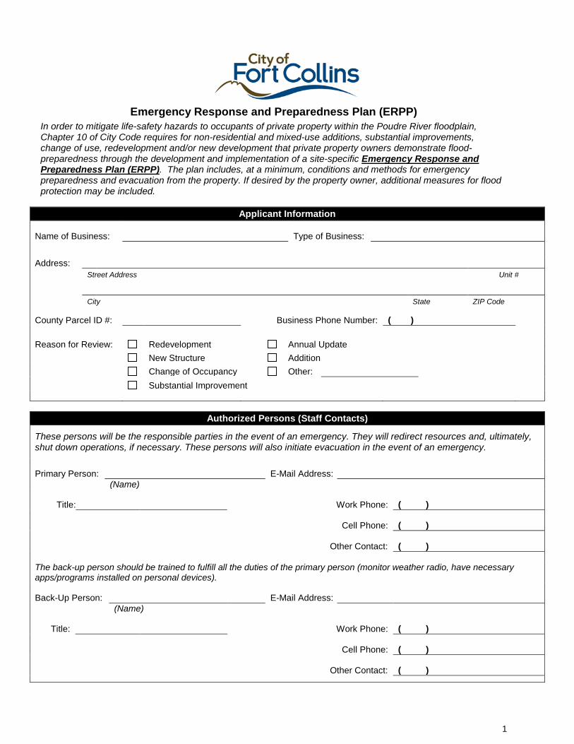
Emergency Response and Preparedness Plan (ERPP) In order to mitigate life-safety hazards to occupants of private property within the Poudre River floodplain, Chapter 10 of City Code requires for non-residential and mixed-use additions, substantial improvements, change of use, redevelopment and/or new development that private property owners demonstrate flood-preparedness through the development and implementation of a site-specific Emergency Response and Preparedness Plan (ERPP). The plan includes, at a minimum, conditions and methods for emergency preparedness and evacuation from the property. If desired by the property owner, additional measures for flood protection may be included.
Applicant Information
Name of Business: Type of Business:
Address: Street Address Unit #
City State ZIP Code
County Parcel ID #: Business Phone Number: ( ) Reason for Review: Redevelopment Annual Update New Structure Addition Change of Occupancy Other: Substantial Improvement
Authorized Persons (Staff Contacts)
These persons will be the responsible parties in the event of an emergency. They will redirect resources and, ultimately, shut down operations, if necessary. These persons will also initiate evacuation in the event of an emergency.
Primary Person: E-Mail Address: (Name)
Title: Work Phone: ( )
Cell Phone: ( )
Other Contact: ( ) The back-up person should be trained to fulfill all the duties of the primary person (monitor weather radio, have necessary apps/programs installed on personal devices).
Back-Up Person: E-Mail Address: (Name)
Title: Work Phone: ( )
Cell Phone: ( )
Other Contact: ( )
1
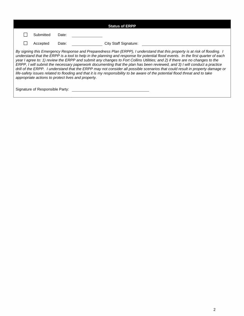
Status of ERPP
Submitted Date:
Accepted Date: City Staff Signature:
By signing this Emergency Response and Preparedness Plan (ERPP), I understand that this property is at risk of flooding. I understand that the ERPP is a tool to help in the planning and response for potential flood events. In the first quarter of each year I agree to: 1) review the ERPP and submit any changes to Fort Collins Utilities; and 2) if there are no changes to the ERPP, I will submit the necessary paperwork documenting that the plan has been reviewed, and 3) I will conduct a practice drill of the ERPP. I understand that the ERPP may not consider all possible scenarios that could result in property damage or life-safety issues related to flooding and that it is my responsibility to be aware of the potential flood threat and to take appropriate actions to protect lives and property.
Signature of Responsible Party:
2
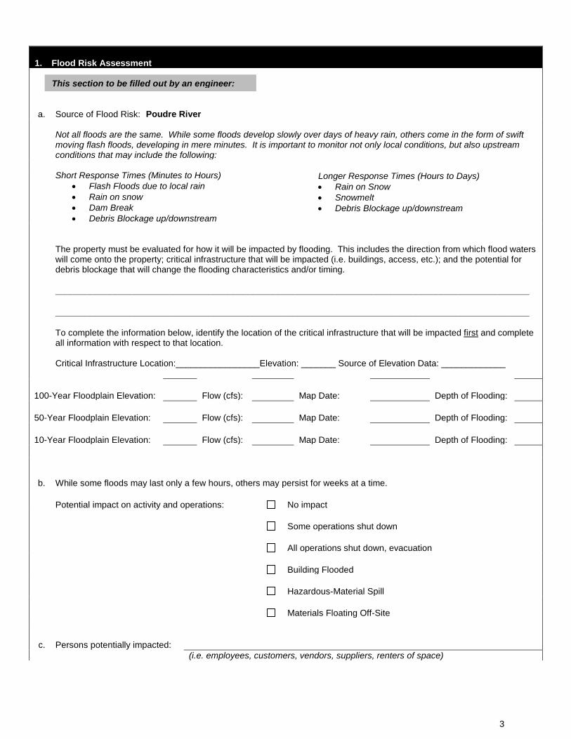
1. Flood Risk Assessment
a. Source of Flood Risk: Poudre River
Not all floods are the same. While some floods develop slowly over days of heavy rain, others come in the form of swift moving flash floods, developing in mere minutes. It is important to monitor not only local conditions, but also upstream conditions that may include the following:
Short Response Times (Minutes to Hours) • Flash Floods due to local rain • Rain on snow • Dam Break • Debris Blockage up/downstream
Longer Response Times (Hours to Days) • Rain on Snow • Snowmelt • Debris Blockage up/downstream
The property must be evaluated for how it will be impacted by flooding. This includes the direction from which flood waters will come onto the property; critical infrastructure that will be impacted (i.e. buildings, access, etc.); and the potential for debris blockage that will change the flooding characteristics and/or timing.
________________________________________________________________________________________________
________________________________________________________________________________________________ To complete the information below, identify the location of the critical infrastructure that will be impacted first and complete all information with respect to that location. Critical Infrastructure Location:_________________Elevation: _______ Source of Elevation Data: _____________
100-Year Floodplain Elevation: Flow (cfs): Map Date: Depth of Flooding:
50-Year Floodplain Elevation: Flow (cfs): Map Date: Depth of Flooding:
10-Year Floodplain Elevation: Flow (cfs): Map Date: Depth of Flooding:
b. While some floods may last only a few hours, others may persist for weeks at a time.
Potential impact on activity and operations: No impact
Some operations shut down
All operations shut down, evacuation
Building Flooded
Hazardous-Material Spill
Materials Floating Off-Site
c. Persons potentially impacted: (i.e. employees, customers, vendors, suppliers, renters of space)
This section to be filled out by an engineer:
3
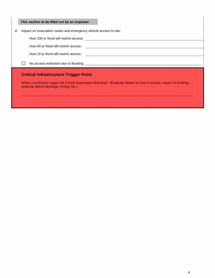
d. Impact on evacuation routes and emergency vehicle access to site:
How 100-yr flood will restrict access:
How 50-yr flood will restrict access:
How 10-yr flood will restrict access: No access restriction due to flooding:_______________________________________________________________
Critical Infrastructure Trigger Point When condition(s) trigger the 2 Hour Evacuation Warning? (Evaluate based on loss of access, impact to building, potential debris blockage, timing, etc.) ____________________________________________________________________________________________
This section to be filled out by an engineer:
4
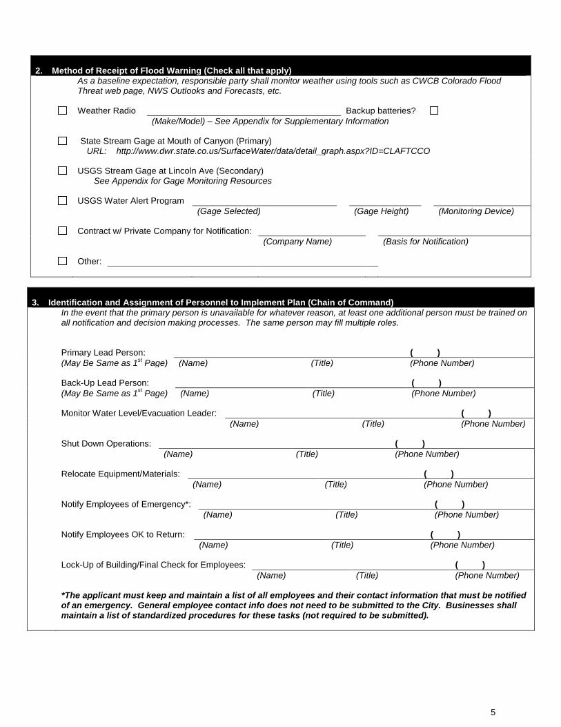
2. Method of Receipt of Flood Warning (Check all that apply)
As a baseline expectation, responsible party shall monitor weather using tools such as CWCB Colorado Flood Threat web page, NWS Outlooks and Forecasts, etc.
Weather Radio Backup batteries? (Make/Model) – See Appendix for Supplementary Information
State Stream Gage at Mouth of Canyon (Primary) URL: http://www.dwr.state.co.us/SurfaceWater/data/detail_graph.aspx?ID=CLAFTCCO
USGS Stream Gage at Lincoln Ave (Secondary) See Appendix for Gage Monitoring Resources
USGS Water Alert Program (Gage Selected) (Gage Height) (Monitoring Device)
Contract w/ Private Company for Notification: (Company Name) (Basis for Notification)
Other:
3. Identification and Assignment of Personnel to Implement Plan (Chain of Command)
In the event that the primary person is unavailable for whatever reason, at least one additional person must be trained on all notification and decision making processes. The same person may fill multiple roles.
Primary Lead Person: ( ) (May Be Same as 1st Page) (Name) (Title) (Phone Number)
Back-Up Lead Person: ( ) (May Be Same as 1st Page) (Name) (Title) (Phone Number)
Monitor Water Level/Evacuation Leader: ( ) (Name) (Title) (Phone Number)
Shut Down Operations: ( ) (Name) (Title) (Phone Number)
Relocate Equipment/Materials: ( ) (Name) (Title) (Phone Number)
Notify Employees of Emergency*: ( ) (Name) (Title) (Phone Number)
Notify Employees OK to Return: ( ) (Name) (Title) (Phone Number)
Lock-Up of Building/Final Check for Employees: ( ) (Name) (Title) (Phone Number)
*The applicant must keep and maintain a list of all employees and their contact information that must be notified of an emergency. General employee contact info does not need to be submitted to the City. Businesses shall maintain a list of standardized procedures for these tasks (not required to be submitted).
5
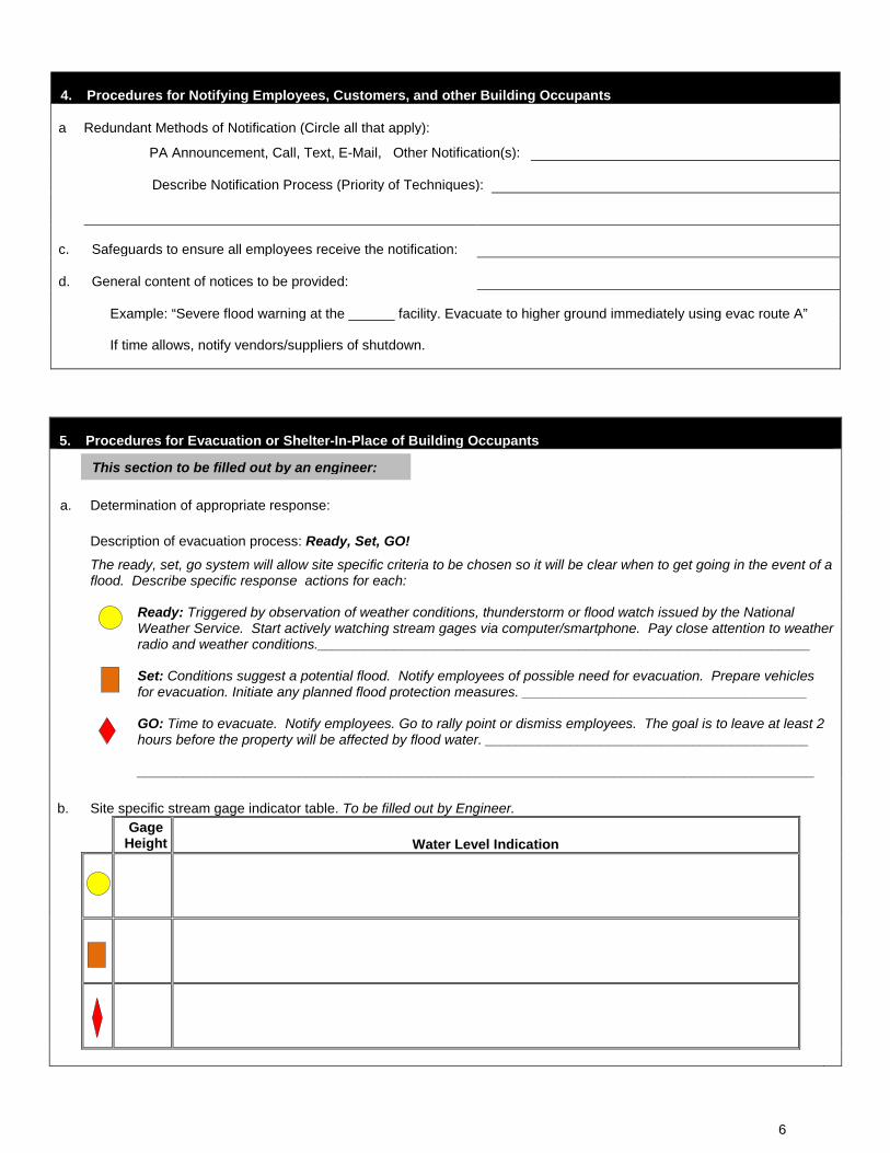
4. Procedures for Notifying Employees, Customers, and other Building Occupants
a Redundant Methods of Notification (Circle all that apply):
PA Announcement, Call, Text, E-Mail, Other Notification(s):
Describe Notification Process (Priority of Techniques):
c. Safeguards to ensure all employees receive the notification:
d. General content of notices to be provided:
Example: “Severe flood warning at the ______ facility. Evacuate to higher ground immediately using evac route A”
If time allows, notify vendors/suppliers of shutdown.
5. Procedures for Evacuation or Shelter-In-Place of Building Occupants
a.
Determination of appropriate response:
Description of evacuation process: Ready, Set, GO!
The ready, set, go system will allow site specific criteria to be chosen so it will be clear when to get going in the event of a flood. Describe specific response actions for each:
Ready: Triggered by observation of weather conditions, thunderstorm or flood watch issued by the National Weather Service. Start actively watching stream gages via computer/smartphone. Pay close attention to weather radio and weather conditions.________________________________________________________________
Set: Conditions suggest a potential flood. Notify employees of possible need for evacuation. Prepare vehicles for evacuation. Initiate any planned flood protection measures. _____________________________________
GO: Time to evacuate. Notify employees. Go to rally point or dismiss employees. The goal is to leave at least 2 hours before the property will be affected by flood water. __________________________________________ ________________________________________________________________________________________
b. Site specific stream gage indicator table. To be filled out by Engineer.
Gage
Height Water Level Indication
This section to be filled out by an engineer:
6
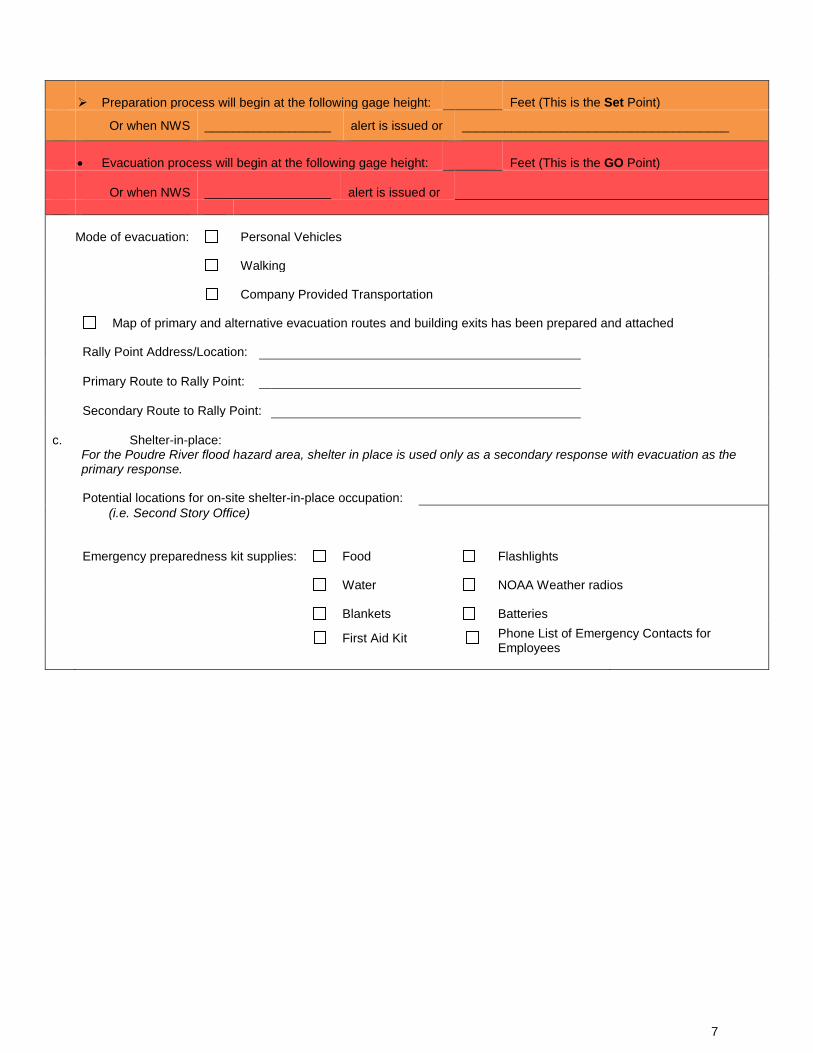
Preparation process will begin at the following gage height: Feet (This is the Set Point)
Or when NWS __________________ alert is issued or ______________________________________
• Evacuation process will begin at the following gage height: Feet (This is the GO Point)
Or when NWS __________________ alert is issued or
Mode of evacuation: Personal Vehicles
Walking
Company Provided Transportation
Map of primary and alternative evacuation routes and building exits has been prepared and attached
Rally Point Address/Location:
Primary Route to Rally Point:
Secondary Route to Rally Point:
c. Shelter-in-place: For the Poudre River flood hazard area, shelter in place is used only as a secondary response with evacuation as the primary response.
Potential locations for on-site shelter-in-place occupation: (i.e. Second Story Office)
Emergency preparedness kit supplies: Food Flashlights
Water NOAA Weather radios
Blankets Batteries
First Aid Kit Phone List of Emergency Contacts for
Employees
7
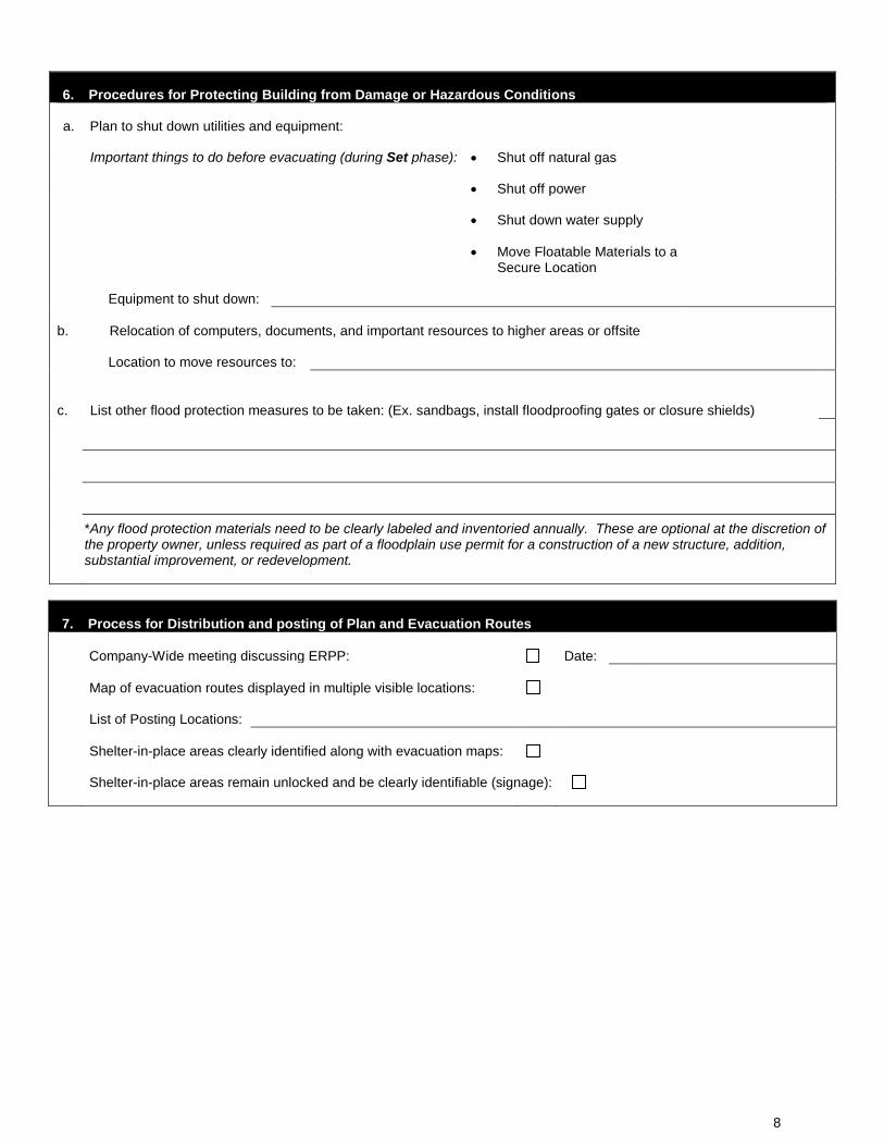
6. Procedures for Protecting Building from Damage or Hazardous Conditions
a. Plan to shut down utilities and equipment:
Important things to do before evacuating (during Set phase): • Shut off natural gas
• Shut off power
• Shut down water supply
• Move Floatable Materials to a
Secure Location
Equipment to shut down:
b. Relocation of computers, documents, and important resources to higher areas or offsite
Location to move resources to:
c.
List other flood protection measures to be taken: (Ex. sandbags, install floodproofing gates or closure shields)
*Any flood protection materials need to be clearly labeled and inventoried annually. These are optional at the discretion of the property owner, unless required as part of a floodplain use permit for a construction of a new structure, addition, substantial improvement, or redevelopment.
7. Process for Distribution and posting of Plan and Evacuation Routes
Company-Wide meeting discussing ERPP: Date:
Map of evacuation routes displayed in multiple visible locations:
List of Posting Locations:
Shelter-in-place areas clearly identified along with evacuation maps:
Shelter-in-place areas remain unlocked and be clearly identifiable (signage):
8
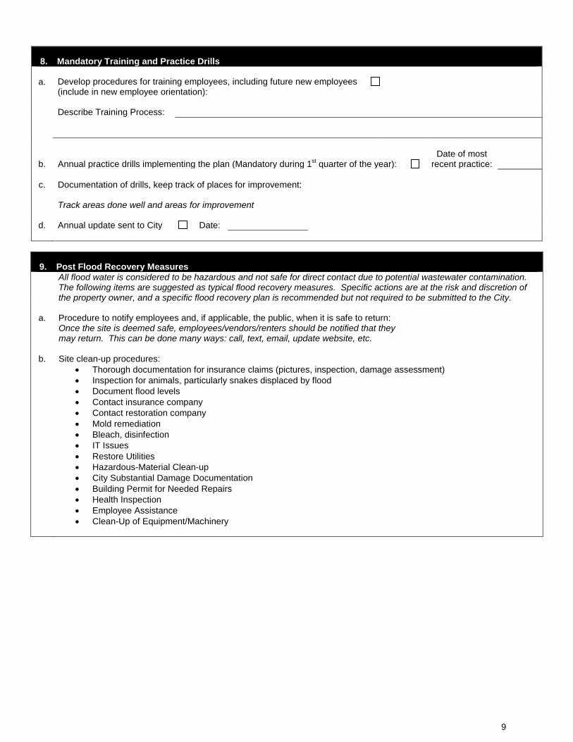
8. Mandatory Training and Practice Drills
a. Develop procedures for training employees, including future new employees (include in new employee orientation):
Describe Training Process:
b. Annual practice drills implementing the plan (Mandatory during 1st quarter of the year): Date of most
recent practice:
c. Documentation of drills, keep track of places for improvement:
Track areas done well and areas for improvement
d. Annual update sent to City Date:
9. Post Flood Recovery Measures
All flood water is considered to be hazardous and not safe for direct contact due to potential wastewater contamination. The following items are suggested as typical flood recovery measures. Specific actions are at the risk and discretion of the property owner, and a specific flood recovery plan is recommended but not required to be submitted to the City.
a. Procedure to notify employees and, if applicable, the public, when it is safe to return:
Once the site is deemed safe, employees/vendors/renters should be notified that they may return. This can be done many ways: call, text, email, update website, etc.
b. Site clean-up procedures:
• Thorough documentation for insurance claims (pictures, inspection, damage assessment) • Inspection for animals, particularly snakes displaced by flood • Document flood levels • Contact insurance company • Contact restoration company • Mold remediation • Bleach, disinfection • IT Issues • Restore Utilities • Hazardous-Material Clean-up • City Substantial Damage Documentation • Building Permit for Needed Repairs • Health Inspection • Employee Assistance • Clean-Up of Equipment/Machinery
9
Appendix – Resources Weather Radios Many brands and models of weather radios are available for purchase. These vary from small desktop units to large scale systems that tie into a PA system. When looking for a weather radio to alert employees and customers of potential emergencies, there are a few key features to look for:
• NWR S.A.M.E. (Specific Area Message Encoding) Capability o Allows user to receive only alerts for selected regions
• Selectable alerting of events o This feature will allow the user to program the radio telling it what type of
alerts to ignore • Battery backup
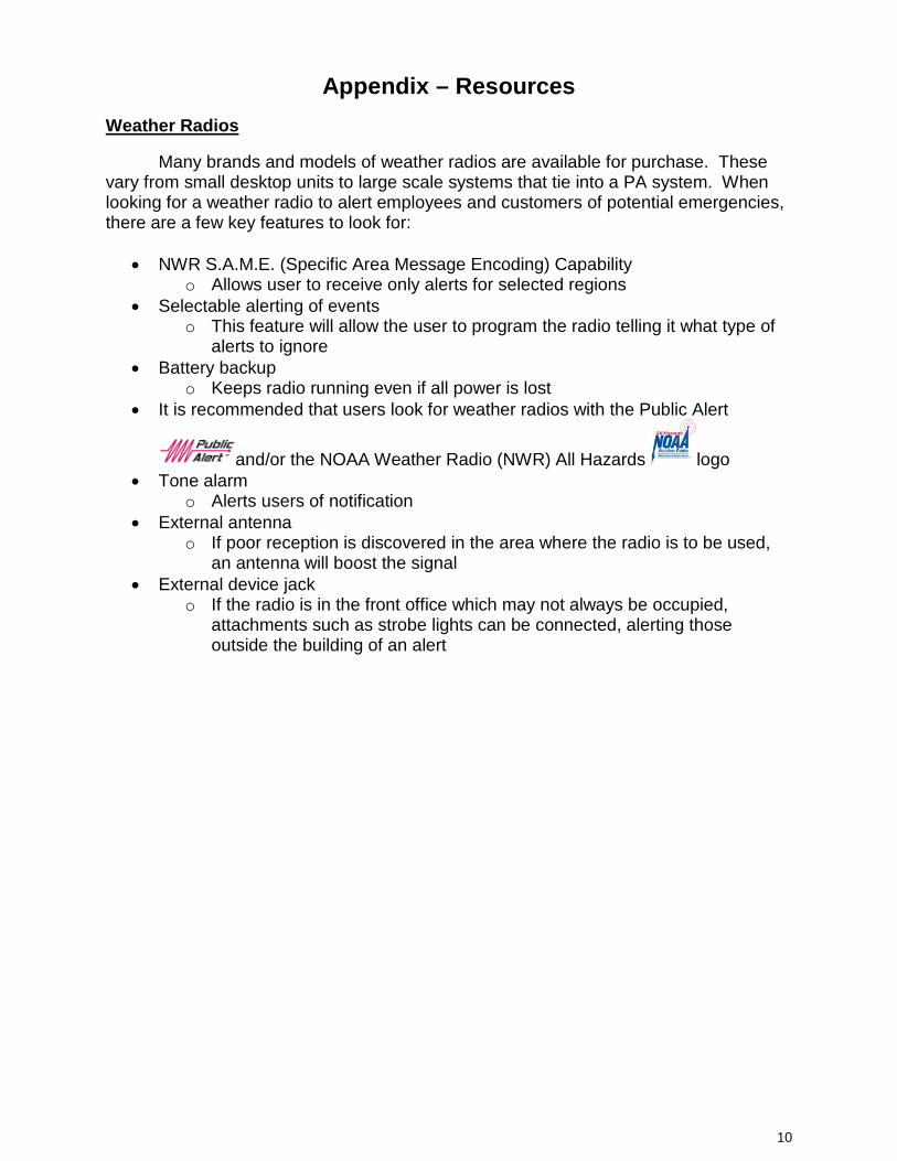
o Keeps radio running even if all power is lost • It is recommended that users look for weather radios with the Public Alert
and/or the NOAA Weather Radio (NWR) All Hazards logo • Tone alarm
o Alerts users of notification • External antenna
o If poor reception is discovered in the area where the radio is to be used, an antenna will boost the signal
• External device jack o If the radio is in the front office which may not always be occupied,
attachments such as strobe lights can be connected, alerting those outside the building of an alert
10
National Weather Service Streamflow levels The NWS notification stages and messaging for the Poudre River at the Mouth of the Canyon (FTDC2) revised 4/20/2010 are as follows: Action Stage: 6.0 ft Bankfull Stage: 6.5 ft Flood Stage: 7.5 ft Flood Categories Minor Flood Stage: 7.5 ft (Through 2011, a 57% chance of occurrence) Moderate Flood Stage: 9.0 ft (Through 2011, <10% chance) Major Flood Stage: 10.5 ft (Through 2011, <10% chance)
Damage – Stage and Areas Affected
6.0 ft The river begins to threaten the McConnell Subdivision in LaPorte
6.5 ft The Cache la Poudre river will begin to overflow into low lying areas in and near Fort Collins
7.5 ft Considerable overbank flow and localized flooding occurs downstream in and near Fort Collins
8.5 ft The river rises to the base of the bridge at College Avenue in Fort Collins
9.0 ft Water flows into homes at College Avenue in Fort Collins
10.5 ft Numerous buildings are flooded in and near the town of LaPorte National Weather Service Watches and Warnings Terms to Know:
Flood Watch
Atmospheric and hydrologic conditions are favorable for long duration areal or river flooding.
Flash Flood Watch
Atmospheric and hydrologic conditions are favorable for short duration flash flooding and/or a dam break is possible.
Flood Advisory
Thunderstorms have produced heavy rainfall that may result in ponding of water on roadways and in low-lying areas, as well as rises in small stream levels.
Flood Warning
Long duration areal or river flooding is imminent or occurring or is imminent, which may result from excessive rainfall, rapid snow melt, ice jams on rivers or other similar causes
Flash Flood Warning
Excessive rainfall producing thunderstorms have developed, leading to short duration flash flooding. Flash flooding is imminent or occurring. A warning may also be issued if a dam break has occurred.
11
Accessing Stream Gages
• Canyon Mouth Stream Gage
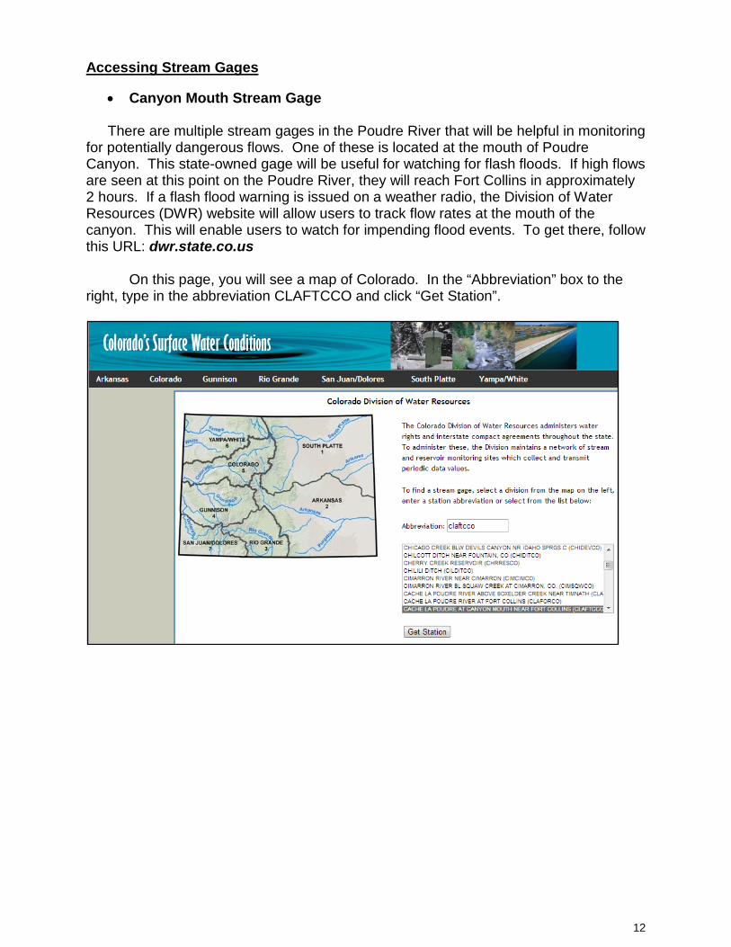
There are multiple stream gages in the Poudre River that will be helpful in monitoring for potentially dangerous flows. One of these is located at the mouth of Poudre Canyon. This state-owned gage will be useful for watching for flash floods. If high flows are seen at this point on the Poudre River, they will reach Fort Collins in approximately 2 hours. If a flash flood warning is issued on a weather radio, the Division of Water Resources (DWR) website will allow users to track flow rates at the mouth of the canyon. This will enable users to watch for impending flood events. To get there, follow this URL: dwr.state.co.us On this page, you will see a map of Colorado. In the “Abbreviation” box to the right, type in the abbreviation CLAFTCCO and click “Get Station”.
12
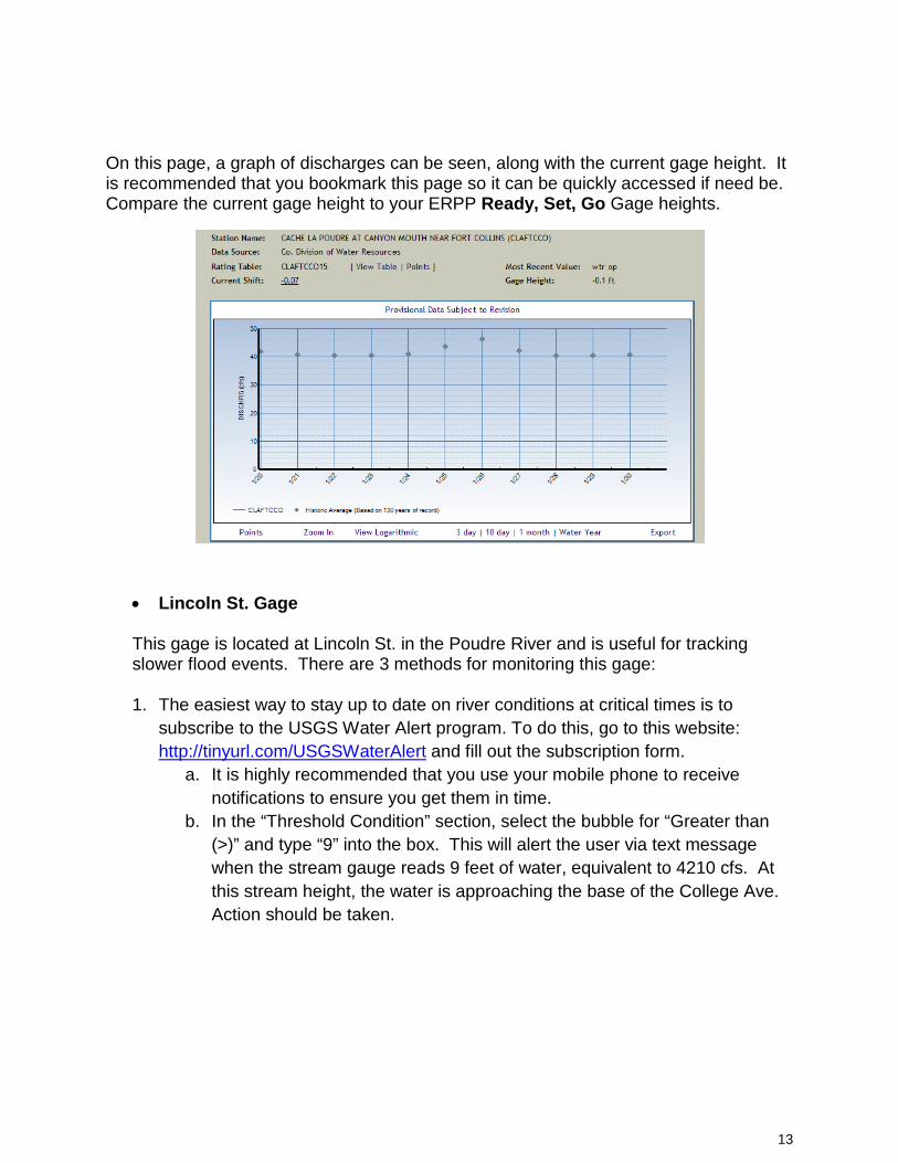
On this page, a graph of discharges can be seen, along with the current gage height. It is recommended that you bookmark this page so it can be quickly accessed if need be. Compare the current gage height to your ERPP Ready, Set, Go Gage heights.
• Lincoln St. Gage
This gage is located at Lincoln St. in the Poudre River and is useful for tracking slower flood events. There are 3 methods for monitoring this gage:
1. The easiest way to stay up to date on river conditions at critical times is to
subscribe to the USGS Water Alert program. To do this, go to this website: http://tinyurl.com/USGSWaterAlert and fill out the subscription form.
a. It is highly recommended that you use your mobile phone to receive notifications to ensure you get them in time.
b. In the “Threshold Condition” section, select the bubble for “Greater than (>)” and type “9” into the box. This will alert the user via text message when the stream gauge reads 9 feet of water, equivalent to 4210 cfs. At this stream height, the water is approaching the base of the College Ave. Action should be taken.
13
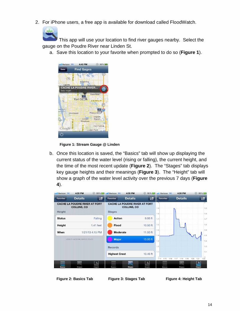
2. For iPhone users, a free app is available for download called FloodWatch.
This app will use your location to find river gauges nearby. Select the gauge on the Poudre River near Linden St.
a. Save this location to your favorite when prompted to do so (Figure 1).
Figure 1: Stream Gauge @ Linden
b. Once this location is saved, the “Basics” tab will show up displaying the current status of the water level (rising or falling), the current height, and the time of the most recent update (Figure 2). The “Stages” tab displays key gauge heights and their meanings (Figure 3). The “Height” tab will show a graph of the water level activity over the previous 7 days (Figure 4).
Figure 2: Basics Tab Figure 3: Stages Tab Figure 4: Height Tab
14
3. The first is to go to the USGS website: waterdata.usgs.gov.
a. From here, click on “Current Conditions” b. On the map of the United States, click on Colorado c. Click the link on the right titles “Colorado Statewide Streamflow Real-Time
Table” d. Scroll down the page until you see “Cache La Poudre” and click on the link
to “06752260 – Cache La Poudre at Fort Collins, CO” e. On this page you will see a graph displaying the flow level in real time f. Compare this depth to the following table
15