Embed Size (px)
Citation preview

EMBARCADERO SEAWALL PROGRAM &
PORT RESILIENCE
San Francisco BayConservation and Development Commission
February 21, 2018
Phot
o |
Mich
ael M
acor
Historic shoreline
Port Jurisdiction

TODAY’S PRESENTATION
• Thank you for letting the Port of San Francisco join you today!
• We’re excited to share:
• Embarcadero Seawall Program:
• History • What it supports • Program updates • Resilience framework • U.S. Army Corps of
Engineers/Port Flood Study
• Schedule • Funding
• Port Resilience Efforts • Port Resilience Projects • Embarcadero Historic District
Stewardship • Requests for engagement

EJ.rV AT IDN-.5 r e. ·11-11· s~-✓- r·. ,:,,.
1 CIWHL
2 ROCK ADDED
3 PR.ES+ IIU.IOEAD WAI.LIIIMN
4 TIMBER REPLACED \IWIHCONCRETE MR'IIE
--
UNDERSTANDING THE EMBARCADERO SEAWALL
• Built 1878 to 1915 • Rock dike & bulkhead • Over 3 miles long • 500 acres of filled land • 126 acres pier & wharves today

MORE THAN $100 BILLION OF TOTAL ANNUAL ECONOMIC ACTIVITY AND PROPERTY VALUE IS AT RISK IF THE SEAWALL FAILS
The value of assets at risk is
10-40x greater than the investment needed to strengthen the Seawall.
THE SEAWALL IS A CRITICAL PART OF THE CITY'S NETWORK OF EMERGENCY RESPONSE In the event of an emergency , the City estimates that up to 250,000 people will require water evacuation
The Seawall also supports over 50 key emergency assets including Fire Station 35 , which houses the fireboat
THE SEAWALL IS KEY TO REGIONAL TRANSPORTATION
• 500,000 people use transit routes every weekday that terminate downtown or along the waterfront
Bicycle counts show that nearly 900 riders use the Embarcadero every day
The Embarcadero Seawa ll supports 15,000 daily ferry riders
THE SEAWALL SUPPORTS AND PROTECTS IMPORTANT UTILITY IINFRASTRUCTURE This includes major wastewater, water, auxiliary water system, and power utilities .
EMBARCADERO SEAWALL TODAY

STRONG GROUND SHAKING
EMBARCADERO CRACKS,
UTILITTES RUPlURE
BUILDING BULKHEAD + COLLAPSES ~ WHARF FAIL
FAILURE OF MUD BELOW DIKE
II
DIKE SLIDES INTO BAY
SAN FRANCISCO FACES URGENT EARTHQUAKE RISKS
72% PROBABILITY for an earthquake of at least 6.7 magnitude to occur between now and 2043

,. ,. ,.. ,. '1! ,.
MUNI+ BART TUNNEL FLDODED Intermittent and
localized flooding today Future SLR risk
Future SLR risk
INCREASING FLOOD RISKS FROM SEA LEVEL RISE • Muni and BART tunnels subject to
flood risk today
• Up to 3 feet by 2050
• Up to 6-10 feet by 2100

EMBARCADERO SEAWALL PROGRAM
OVERVIEW • First priority is to protect life
safety and emergency response from seismic events
• Up to $5 billion over 30+ years
• Funding and financing from City, state, federal and private
• Will address as much flood risk as possible and create a foundation for addressing flood risk
• Adaptive program framework to be able to respond to changes in science, priorities and monitoring
• Robust engagement and outreach

SEAWALL PROGRAM YEAR IN REVIEW
DATA COLLECTION + FIELD WORK • Existing Assets • Bathymetric & Laser Survey • Geotechnical Exploration
RISK ASSESSMENT • Earthquake Risk • Flood Risk
COMMUNITY & STAKEHOLDER ENGAGEMENT
FUNDING FOR PHASE I: IMMEDIATE LIFE SAFETY RISKS
ARMY CORPS FLOOD STUDY

• ... "4
...... t;., ...
" '
\ ~ ........ "Hr~ -at d'C"':
........ -c ... «t • ._..e- at.4,1:. ....
... . ... ,~ .. ~ ......
CITYWIDE SUPPORT FOR THE SEAWALL PROGRAM
Spring 2017: 9% of San Franciscans were very familiar with the Embarcadero Seawall
November 2018: 82% of San Franciscans voted in favor of ballot to strengthen Embarcadero Seawall
LOVE SA N l=~ A N C I S:C O ' S
WATE RFRO N T1
c;rr re ru,:o;v 'THt t::MB/ iRCAOJ::ttO SC...,'\V/.'\Ll! U:M -~.r-10.ti:.t:..-!:t '.:\F,SfAW,!\1 .'.,.COM
----..... -.._ ___ _ ___ .._
-·-____ ...,._ ---~ ----"' .. " ----......... <- .
_,,, ___ ._..._ _____ ..,..., ____ ., !:.--~=-.. _...,. ___ _
PUPl
.__,_ , ____ _ ,___~_ ..., --··-• .. .,__, __ _ --____ .._
=-·""- .
no11---••f'GA.lill,tr_,_ ,._.,._. ... ____ __ . ,,_ __ _
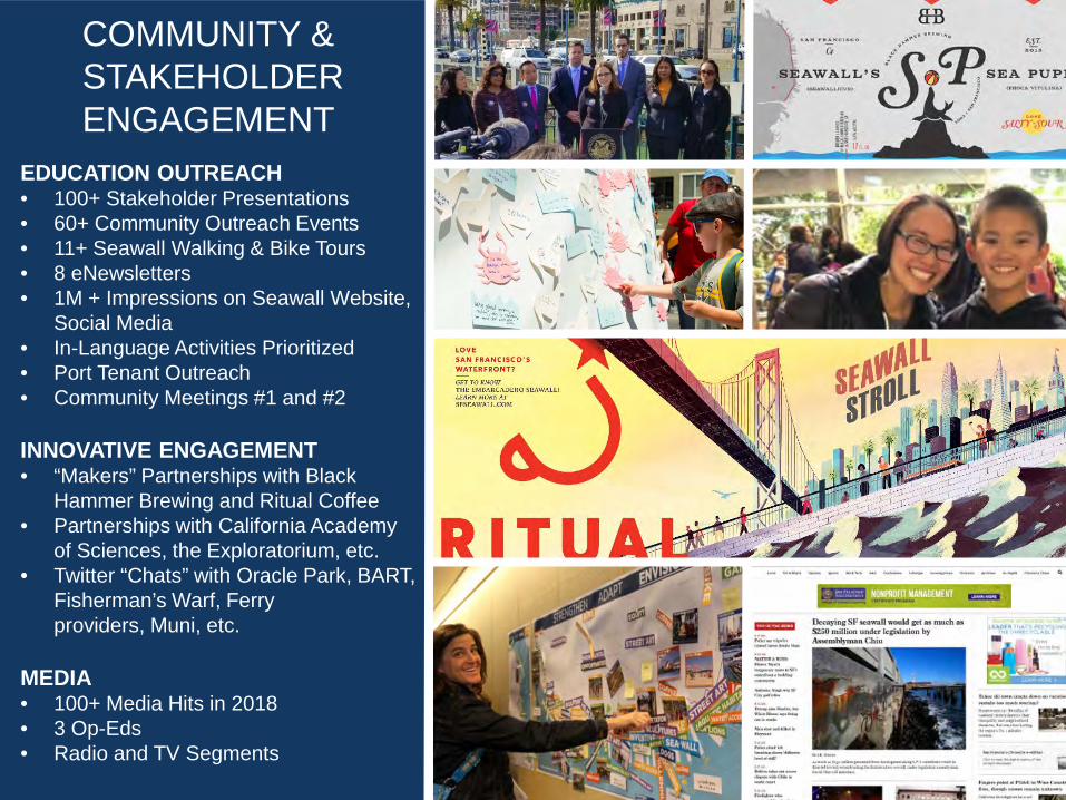
COMMUNITY & STAKEHOLDER ENGAGEMENT
EDUCATION OUTREACH • 100+ Stakeholder Presentations • 60+ Community Outreach Events • 11+ Seawall Walking & Bike Tours • 8 eNewsletters • 1M + Impressions on Seawall Website,
Social Media • In-Language Activities Prioritized • Port Tenant Outreach • Community Meetings #1 and #2
INNOVATIVE ENGAGEMENT • “Makers” Partnerships with Black
Hammer Brewing and Ritual Coffee • Partnerships with California Academy
of Sciences, the Exploratorium, etc. • Twitter “Chats” with Oracle Park, BART,
Fisherman’s Warf, Ferry providers, Muni, etc.
MEDIA • 100+ Media Hits in 2018 • 3 Op-Eds • Radio and TV Segments 10

The Port collected information on existing assets with City agencies, partners, and community stakeholders
INFRASTRUCTURE URBAN AND CULTURAL
MARITIME DISASTER RESPONSE PARKS AND ECOSYSTEMS
DATA COLLECTION: EXISTING ASSETS

FIELD WORK: BATHYMETRIC AND LASER SURVEY
The Bathymetric Survey measured the water depth along the Embarcadero Seawall.
Survey results will inform the seismic and flood analysis modeling for the Seawall.

• ~ . ,. • • ,. ' .... , .. . ,/ '· /
' < '·
.• ~ .
• . .
1 I
·-. ,, .... , :l ~ ... .. .. I , ,. , ,., . .... ~. ,.,,, . :: "''•
FIELD WORK: GEOTECHNICAL EXPLORATION
• Completed approximately 100 exploratory borings along the Embarcadero Seawall
• Borings help to better understand subsurface conditions and evaluate potential earthquake effects
5-~-18 1107 ¢t,:,p 1'964lS
D",ni!fflt: 'Tl!fe sooooe,01 'U(l!)f-o(Q~>;« 500):♦02 .1.,ooe-02q"' 1.o:a: • 02
CCffl/Jl.r tiler,$~ 5JXE-Oi
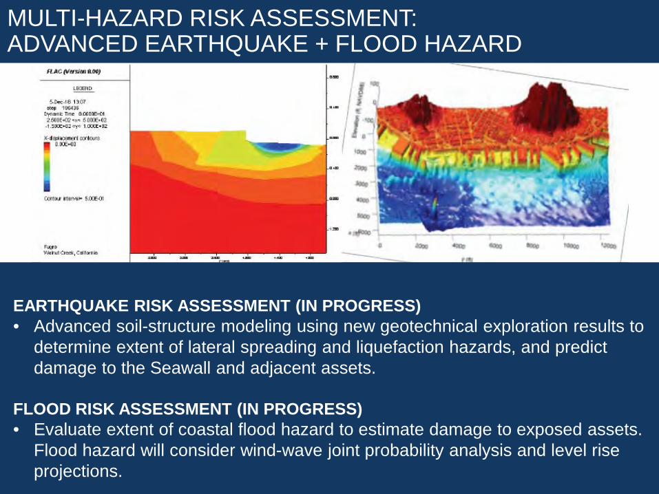
MULTI-HAZARD RISK ASSESSMENT: ADVANCED EARTHQUAKE + FLOOD HAZARD
EARTHQUAKE RISK ASSESSMENT (IN PROGRESS) • Advanced soil-structure modeling using new geotechnical exploration results to
determine extent of lateral spreading and liquefaction hazards, and predict damage to the Seawall and adjacent assets.
FLOOD RISK ASSESSMENT (IN PROGRESS) • Evaluate extent of coastal flood hazard to estimate damage to exposed assets.
Flood hazard will consider wind-wave joint probability analysis and level rise projections.

P H A S E P H A S E P H A S E
1 ® ® STRENGTHEN ADAPT ENVISION
ELEMENT ELEMENT ELEMENT
STRENGTHEN ADAPT TO ENVISION TH E SEAWA LL MID-CE NTURY THE WATERFRONT FOR PUBLIC RISKS IN 2100
SAFETY
PORT AND SEAWALL RESILIENCE FRAMEWORK
Objective: Immediately implement highest priority disaster response and life safety projects along the Embarcadero Seawall
Planning and Implementation Horizon: 2018 – 2026
Priorities: Current Seismic & Flood Risk
Geographic Focus: Embarcadero Seawall
Objective: Identify policies and projects that will result in a Port that is resilient to seismic and increasing flood risks and that can respond to changing priorities. Projects will be integrated into city, regional, and private actions, resulting in coordinated actions to increase waterfront resilience.
Planning and Implementation Horizon: 2018 – 2050, Plan updated every five years
Priorities: Seismic Risk and Future Flood Risk
Geographic Focus: Entire Port Jurisdiction
Objective: Develop visions that can respond to remaining seismic risk and increasing flood risks and have an ongoing public conversation about the trade-offs of different options.
Planning and Implementation Horizon: 2018 – 2100, Vision Element updated every 10 years
Priorities: Seismic Risk and Future Flood Risk
Geographic Focus: Entire Port Jurisdiction

USACE/PORT FLOOD STUDY
FISHERMAN’ S WHARF
ISLAIS CREEK
HIGHLIGHTS • Federal funding, expertise, partnership • Port is the local sponsor, seeking assistance since 2012 • Flood Study is entire Port jurisdiction • No limit to the scale, extent or cost of projects • Suspend CAP 103, use prior work in GI
STUDY OVERVIEW • Estimate 4-1/2 years & $6M, 50/50 cost share • Evaluate flood risk to entire Port, develop and evaluate a wide
range of alternatives • Culminates in a recommendation to Congress to authorize and
fund design & construction of selected plan. • Design/construction of federal plan cost shared 65% fed / 35%
local • Locally preferred plan can be selected, sponsor pays extra
cost
& PPA
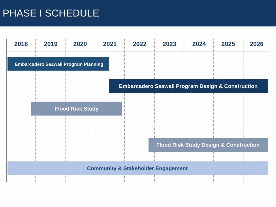
PHASE I SCHEDULE
2020 2021 2022 2023 2024 2025 2026 2019 2018
Flood Risk Study
Flood Risk Study Design & Construction
WRDA
Embarcadero Seawall Program Planning
Embarcadero Seawall Program Design & Construction
Community & Stakeholder Engagement

LOCAL
25%
PRIVATE
25%
$5 billion:
LOCAL • •
FEDERAL •
• •
STATE • •
PRIVATE •
SEAWALL PROGRAM FUNDING
NEXT STEPS The Port is currently pursuing local, state, federal, and private funding sources to fully fund infrastructure improvements anticipated to cost up to
City GO Bond Programs Other
US Army Corps of Engineers – USACE/Port Flood Study Water Resources Transportation
Cap and Trade State Share of Tax Increments
Waterfront Development Project • Businesses

PORT RESILIENCE EFFORTS
PORT WIDE EMBARCADERO MISSION BAY ISLAIS CREEK/ BAYVIEW
FLOOD PROOF PIERS
FLOOD STUDY
SEAWALL PROGRAM
RFI
FLOOD STUDY
SOUTHERN WATERFRONT ASSESSMENT
FLOOD STUDY
ISLAIS CREEK FLOOD STUDY
SOUTHERN WATERFRONT ASSESSMENT
PORTWIDE RESILIENCE
ADAPTIVE FRAMEWORK
RFI
UTILITIES PROJECTS
PROJECT ADAPTATIONS

RESILIENCE PROJECTS
DOWNTOWN FERRY TERMINAL • New Pier and Terminal
Expansion under construction • 3 feet higher than prior terminals
due to SLR • Massive steel piles to withstand
up to 6 feet of lateral spreading

MISSION BAY FERRY LANDING
• Design accommodates Sea Level Rise through 2070 with resilience and future adaptability beyond
• Designed to appropriate California Building Code Risk Category for first response and evacuation in the event of a catastrophe

PIER 70 &
MISSION ROCK PIER 70 • To deliver up to 3,000 homes, nine
acres of parks, and significant sea level rise protections such as elevating the site and buildings to accommodate up to six feet inches of sea level rise
• The project will generate an estimated $88 million to be used for Port-wide sea level rise adaptation
MISSION ROCK/PIER 48 • To deliver new homes, raise the site to
withstand up to 6 feet of sea level rise, and transition China Basin Park to allow flooding in low-lying park areas
• The project establishes an ongoing Shoreline Protection revenue stream

Pier 4,8 Pier 4.0 f;>ier 38 Pier 2,8 l;'ier 26 I I I I
Mission~
I. T&T;;;
■ RFI Location Seismically Improved
Agriculture Building Piers 23, 19 ½, & J9 Pier 2~ & 29 ½ ,Piers 31 & 33 _pier 35
Fisherman's Wnarf
y ~Pier39
Ferry Building
Terminal
- - - - Port Property
EMBARCADERO HISTORIC DISTRICT STEWARDSHIP
• Pier 45 (Fishermans’ Wharf) to Pier 48 (China Basin) • 5 successful historic rehabilitation projects • 15 facilities yet to be repaired & improved
LEVERAGE SEAWALL IMPROVEMENT TO OPEN MORE HISTORIC PIERS TO THE PUBLIC
• The Embarcadero Historic District is a result from Port & BCDC collaboration in 2000
• People love the Ferry Building, Exploratorium and Piers 1-5 and seek more pier rehabilitation
• The Port received 52 responses with diverse ideas for public-oriented uses
• Embarcadero Historic District Public Trust Objectives recommended in Waterfront Plan Update
• Collaborate to develop a shared BCDC + State Lands + Port strategy

REQUESTS FOR BCDC ENGAGEMENT
RESOURCE & REGULATORY AGENCY WORKING GROUP PARTICIPATION • Help inform the Embarcadero
Seawall Program and the Flood Study
COLLABORATE ON LOCAL & REGIONAL RESILIENCE EFFORTS • Adapting to Rising Tides Program • Public engagement around Sea
Level Rise • Current and upcoming Bay Plan
amendments
PUBLIC ENGAGEMENT EFFORTS • Help us reach new voices