Embed Size (px)
DESCRIPTION
information
Citation preview
Alexco Resource Corporation
Mineral Resource Estimation Elsa Tailings Project
Yukon, Canada
Report Prepared for
Alexco Resource Corporation Suite 1150 – 200 Granville Street
Vancouver, BC Canada, V6C 1S4
Report Prepared by
SRK CONSULTING (CANADA) INC. Suite 2100, 25 Adelaide Street East
Toronto, ON M5C 3A1 Tel: (416) 601-1445
Fax: (416) 601-9046 Web Address: www.srk.com
E-mail: [email protected]
Project Reference Number: 3CA020.003
16 June 2010
SRK Consulting 3CA020.003 – Alexco Resource Corp. Mineral Resource Estimation, Elsa Tailings Project Page i
LW – GDK / jfc – ab -jps Alexco_Tailing_Resource_TR_3CA020_003_LW_GDK_ab_jfc_JPS_20100616.doc June 16, 2010
Mineral Resource Estimation Elsa Tailings Project Yukon, Canada
Alexco Resource Corporation Suite 1150 – 200 Granville Street Vancouver, BC V6C 1S4 Tel: (604) 633-4888 • Fax: (604) 633-4887 E-mail: [email protected] Web Address: www.alexcoresource.com
SRK Project Number 3CA020.003 SRK CONSULTING (CANADA) INC. Suite 2100, 25 Adelaide Street East Toronto, ON M5C 3A1 Tel: (416) 601-1445 • Fax: (416) 601-9046 E-mail: [email protected] Web Address: www.srk.com
June 16, 2010 Compiled by:
G. David Keller, P.Geo Lars Weiershäuser, Ph.D, P.Geo Principal Resource Geologist Senior Geologist Reviewed by:
Jean-François Couture, Ph.D., P.Geo Principal Geologist
SRK Consulting 3CA020.003 – Alexco Resource Corp. Mineral Resource Estimation, Elsa Tailings Project Page ii
LW – GDK / jfc – ab -jps Alexco_Tailing_Resource_TR_3CA020_003_LW_GDK_ab_jfc_JPS_20100616.doc June 16, 2010
Executive Summary Introduction The Elsa Tailings Project is an advanced project exploring the mineral potential of historical tailings from the former United Keno Hill Mines (“UKHM”) mill located in the town of Elsa, Yukon. The Elsa tailings are impounded on the south-eastern slopes of the McQuesten River valley approximately 400 metres from the UKHM mill Milling operations at Elsa started in the 1930s and continued almost without interruption until 1988. Historical production records indicate that approximately 4,050,000 tons of tailings were deposited at the Elsa site. Historical resource estimates on the Elsa Tailings Project were made by UKHM in 1970 and 1988. On June 29, 2009 SRK Consulting (Canada) Inc. (“SRK”) was commissioned by Alexco Resource Corporation (“Alexco”) to prepare a mineral resource estimate for the Elsa Tailings Project. The resource herein represents a first resource estimate for the deposit prepared for Alexco. This technical report documents the resource model constructed by SRK. It was prepared following the guidelines of the Canadian Securities Administrators’ National Instrument 43-101 and Form 43-101F1, and in conformity with generally accepted CIM “Estimation of Mineral Resources and Mineral Reserves Best Practice Guidelines.” Property Description and Agreements The land under the control of Alexco comprises 717 surveyed quartz mining leases, 864 unsurveyed quartz mining claims, and two crown grants. The total area approximates 24,300 hectares. Certain UKHM claims may be subject to unknown or unregistered royalties and/or agreements. Quartz mining leases provide mineral title to the area occupied by the tailings and are part of a large land package controlled by Alexco through its subsidiaries, Elsa Reclamation and Development Co. (“ERDC”) and Alexco Keno Hill Mining Corp. The tailings are located on Quartz Leases: Orchid 1, 3, 15, 26, 31 & 37; Betty and Mud. Alexco’s rights to much of the Keno Hill property are held through the ERDC, a wholly owned subsidiary. In June 2005, PriceWaterhouseCoopers LLP (“PWC”), a court appointed interim receiver and receiver-manager of United Keno Hill Mines Limited and UKH Minerals Limited (collectively “UKHM”), selected Alexco as the preferred purchaser of the assets of UKHM. In February 2006, following negotiation of a Subsidiary Agreement between the Government of Canada, the Government of Yukon, and Alexco, the Supreme Court of Yukon approved the purchase of the assets of UKHM by Alexco through its wholly owned subsidiary, ERDC. The UKHM assets comprised two Crown Grants, 674 mining leases, 289 mineral claims, an ore concentration plant, various buildings and equipment, as well as partial ownership interest in three mining leases, 36 mineral claims, in addition to a leasehold interest in one mineral claim. PWC and Alexco entered into an agreement (the “Purchase Agreement”) dated August 4, 2005, as amended on November 2, 2005 and January 31, 2006. Alexco assigned the Purchase Agreement to its wholly owned subsidiary ERDC on February 6, 2006. “Interim Closing” of the UKHM transaction was completed on April 18, 2006. Alexco assumed responsibility for care and maintenance operations at the UKHM property. On November 30, 2006, Alexco terminated a contract with a
SRK Consulting 3CA020.003 – Alexco Resource Corp. Mineral Resource Estimation, Elsa Tailings Project Page iii
LW – GDK / jfc – ab -jps Alexco_Tailing_Resource_TR_3CA020_003_LW_GDK_ab_jfc_JPS_20100616.doc June 16, 2010
local contractor and started conducting operations utilizing its own employees and equipment. Title to all UKHM assets was transferred to Alexco (“Final Closing”) in November 2007, following the approval of a “Type B” Water License by the Yukon Water Board. All quartz mining leases have been legally surveyed whereas the quartz mining claims have not. In addition, in 2006 and 2007, 650399 BC Ltd., a wholly owned Alexco subsidiary, staked 673 mineral claims (full size and fractional) adjacent to and contiguous with the UKHM property and purchased 36 quartz claims and 37 quartz mining leases from a third party. In 2008 and 2009, Alexco took four existing claims to lease, acquired an additional 18 claims from a third party, and amalgamated 55 additional existing bordering claims into the holdings. Mineral exploration at Keno Hill was initially permitted under the terms and conditions set out by the Yukon Government in the Class III Quartz Mining Land Use Permit – LQ00186, issued on July 5, 2006 and valid until July 4, 2011. Alexco subsequently obtained a Class IV Quartz Mining Land Use Permit – LQ00240 on June 17, 2008. The two permits were amalgamated on December 8, 2008 under #LQ00240 which is valid until December 16, 2018. Under the terms of a legal agreement with the Government of Canada and the Government of Yukon, Alexco is indemnified from any and all environmental liability that may be presented by the historic tailings. However, if Alexco were to nominate any part of the tailings as a production unit under the above agreement, responsibility for addressing water- related environmental liabilities would fall to Alexco. Location Access and Physiography The Elsa Tailings Project is included within the historic Keno Hill mining camp, located in central Yukon. The closest town is Mayo, located on the Stewart River, about 45 kilometres to the south. Mayo is accessible from Whitehorse via a 407 kilometre all weather road; the town is also serviced by Mayo airport, which is located just to the north. A gravel all-weather road leads from Mayo to the project areas. Historically, the mining camp was linked by river route to the outside world; since 1950, the all-weather highway, which was also used for transporting the ore, has been the main link. The Keno Hill area is characterized by rolling hills and mountains with relief up to 1200 metres. Slopes are generally gentle with steeper slopes on the north sides of Keno Hill and Sourdough Hill. The Elsa Tailings are located on the south slope of the McQuesten valley centred along the Flat and Porcupine Creek drainages. History Milling operations at Elsa started in the 1930s, operating almost continuously until 1988. A lead concentrate with a periodic zinc concentrate was produced from milling operations. A cyanide leach circuit was added in 1958 and operated periodically to 1981 depending on prevailing economics. It is estimated that in total approximately 4,050,000 tons of tailings were deposited at the Elsa site. Most of this material was allowed to run out onto the flank of the adjacent valley without engineered impoundment. The original ground surface was covered with small trees, brush and a vegetative mat of moss, all of which was eventually covered by the tailings. The northern portion of the tailings was drilled by UKHM in 1970 and in a second drilling campaign from 1987 to 1988 covering the rest of the tailings area at that time.
SRK Consulting 3CA020.003 – Alexco Resource Corp. Mineral Resource Estimation, Elsa Tailings Project Page iv
LW – GDK / jfc – ab -jps Alexco_Tailing_Resource_TR_3CA020_003_LW_GDK_ab_jfc_JPS_20100616.doc June 16, 2010
Metallurgical testing of the tailings was undertaken in 1988 and 1995 by UKHM and a joint venture between UKHM and government agencies. Regional and Local Geology The tailings lie on the south slope of the McQuesten valley. The rounded out shape of the valley can be attributed to at least one episode of glaciation followed by the deposition of glaciofluvial sands and gravels related to kame terraces. The glaciofluvial sands and gravels were deposited at higher valley elevations with till deposited at lower valley sides and valley bottoms. During the retreat of glacial ice the McQuesten valley bottom was covered by a shallow lake resulting in the deposition of lacustrine silt. The lacustrine silt became increasingly organic and transitioned to peat as the glacial lake became in filled with sediments. The Elsa Tailings cover an irregular area of approximately 130 hectares and range from 0.1 to over 4 metres in thickness. While the valley flank on which the tailings have been deposited is relatively smooth topographically, points of higher elevation occur as uncovered “islands” within the body of the tailings. The earliest site of tailings deposition appears to have been directly into Porcupine Creek with the material being mostly flushed downstream into Flat Creek. Beginning in 1946, tailings were directed away from the creeks producing small terraced accumulations immediately below the mill. Somewhat later a pipeline was constructed that discharged tailings further into the valley in the area between Porcupine and Flat Creek. Ten major mines supplied feed to the Elsa Mill during its operation in the 1930s through 1950s.From the 1960s to 1980s ore was processed by the mill underwent a transition from high grade mineralization to lower grade mineralization from small open pits and underground operations. Deposit Type and Mineralization The tailings consist of generally unconsolidated silty fine grained sand with minor medium sand grained material, of a variable grey to light brown colour characterized by thin beds to laminae. Detailed mineralogical examination shows that the sand grains are angular and locally aggregated and cemented by limonite. The dominant minerals are quartz and siderite (80 percent) with the balance composed of muscovite and other silicate minerals along with pyrite. Occasional grains contain lead and zinc sulphides and trace amounts of lead and zinc oxide minerals have been identified. Drilling UKHM initially carried out a percussion drilling program targeting the thicker northern portion of the tailings in 1970. A total of 114 vertical drill holes were drilled to an average depth of three metres. Drill hole spacing was reported at approximately 60 metres. From 1987 to 1988 a second drilling program was completed by UKHM using a rotary drill for a total of 379 vertical holes (1,770 metres). Alexco and SRK examined historical data and methodologies associated with these programs and conclude that UKHM drilling data were too unreliable to be used for resource evaluation and classification according to CIM best practice guidelines. Alexco drilled 283 vertical sonic drill holes over the deposit in 2009 for a total of 910 drilled metres. The Alexco drilling campaign consisted of drill holes spaced at 50 metres with lines orientated at an azimuth of 45 degrees. Average thickness of the tailings is 2.3 metres ranging from a maximum thickness of 7.5 metres to a minimum of 0.2 metres.
SRK Consulting 3CA020.003 – Alexco Resource Corp. Mineral Resource Estimation, Elsa Tailings Project Page v
LW – GDK / jfc – ab -jps Alexco_Tailing_Resource_TR_3CA020_003_LW_GDK_ab_jfc_JPS_20100616.doc June 16, 2010
Tailings core material is inherently difficult to handle as it is unconsolidated and, in some cases, is saturated with water. Because of the nature of the core material some challenges in core recovery, logging and sample collection exist. SRK is of the opinion that the drilling and sampling performed by Alexco was conducted with care and that the location and handling of the core yielded reasonable samples. Sampling Method, Approach and Analyses Drill core was sampled generally at each run length of 1.5 metres or to the lower tailings contact. The entire core was sampled to provide a known volume for density measurements. Sampled core intervals were placed in polyethylene bags secured with “zip ties.” All samples were analyzed by the ISO 9001 accredited ALS Chemex laboratory in North Vancouver, British Columbia. Upon receipt, samples were placed under ovens for high temperature drying and weighed when dry. Following splitting and pulverization samples were analyzed using inductively coupled plasma-atomic emission spectrometry using a four acid digestion. Thirty three elements including silver, lead and zinc were analyzed using this method. Gold assays were analyzed using fire assay with atomic absorption spectrometry. Quality control samples were placed systematically into the sample stream. Every 20 samples contained at least one blank sample, one standard of known value, and one request for a duplicate assay of the previous sample. The dry density for each of the 2009 sonic drill samples was determined for each of the assayed cores. Dry density was calculated using the dry weight of the sample from the assay laboratory divided by the drilled interval volume which was based on sampled interval length and the inside diameter of the core tube. Data Verification SRK compared 10 percent of the drill hole data assays to original assay certificates. No errors were found in the drill hole assay data base. During the site visit, SRK examined three pits and briefly logged the pit walls of three trenches. SRK also reviewed drill core photos for the sampling program. Mineral Resource Estimation Resources were estimated based on 283 drill holes from the 2009 Alexco sonic drilling program. The data set comprises 546 sampled intervals with silver, lead, zinc and gold assays. A wireframe model of the tailings body was generated by Alexco using high resolution topographic surveys and tailings/sub-surface contacts from the drilling program. Based on tailings assays the tailings area was subdivided into five domains: A low grade silver-lead, low grade gold, high grade silver-lead, high grade gold, and a zinc-specific gravity domain. A sixth separate domain was created for an isolated area away from the main tailings impoundment. All tailings drill holes were composited to 1.5 metre intervals from top to bottom with a minimum composite length of 0.20 metres to allow for thin portions of the tailings impoundment. A review of composite statistics and cumulative frequency plots for the
SRK Consulting 3CA020.003 – Alexco Resource Corp. Mineral Resource Estimation, Elsa Tailings Project Page vi
LW – GDK / jfc – ab -jps Alexco_Tailing_Resource_TR_3CA020_003_LW_GDK_ab_jfc_JPS_20100616.doc June 16, 2010
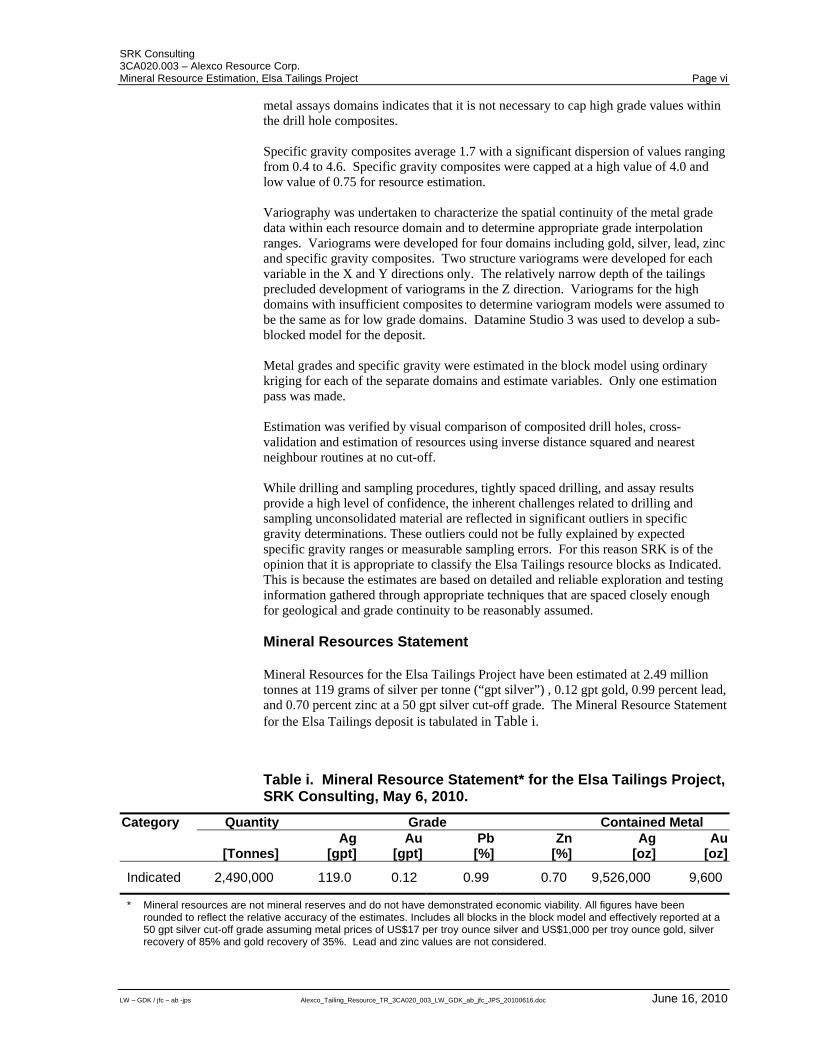
metal assays domains indicates that it is not necessary to cap high grade values within the drill hole composites. Specific gravity composites average 1.7 with a significant dispersion of values ranging from 0.4 to 4.6. Specific gravity composites were capped at a high value of 4.0 and low value of 0.75 for resource estimation. Variography was undertaken to characterize the spatial continuity of the metal grade data within each resource domain and to determine appropriate grade interpolation ranges. Variograms were developed for four domains including gold, silver, lead, zinc and specific gravity composites. Two structure variograms were developed for each variable in the X and Y directions only. The relatively narrow depth of the tailings precluded development of variograms in the Z direction. Variograms for the high domains with insufficient composites to determine variogram models were assumed to be the same as for low grade domains. Datamine Studio 3 was used to develop a sub-blocked model for the deposit. Metal grades and specific gravity were estimated in the block model using ordinary kriging for each of the separate domains and estimate variables. Only one estimation pass was made. Estimation was verified by visual comparison of composited drill holes, cross-validation and estimation of resources using inverse distance squared and nearest neighbour routines at no cut-off. While drilling and sampling procedures, tightly spaced drilling, and assay results provide a high level of confidence, the inherent challenges related to drilling and sampling unconsolidated material are reflected in significant outliers in specific gravity determinations. These outliers could not be fully explained by expected specific gravity ranges or measurable sampling errors. For this reason SRK is of the opinion that it is appropriate to classify the Elsa Tailings resource blocks as Indicated. This is because the estimates are based on detailed and reliable exploration and testing information gathered through appropriate techniques that are spaced closely enough for geological and grade continuity to be reasonably assumed. Mineral Resources Statement Mineral Resources for the Elsa Tailings Project have been estimated at 2.49 million tonnes at 119 grams of silver per tonne (“gpt silver”) , 0.12 gpt gold, 0.99 percent lead, and 0.70 percent zinc at a 50 gpt silver cut-off grade. The Mineral Resource Statement for the Elsa Tailings deposit is tabulated in Table i.
Table i. Mineral Resource Statement* for the Elsa Tailings Project, SRK Consulting, May 6, 2010.
Category Quantity Grade Contained Metal Ag Au Pb Zn Ag Au [Tonnes] [gpt] [gpt] [%] [%] [oz] [oz]
Indicated 2,490,000 119.0 0.12 0.99 0.70 9,526,000 9,600
* Mineral resources are not mineral reserves and do not have demonstrated economic viability. All figures have been rounded to reflect the relative accuracy of the estimates. Includes all blocks in the block model and effectively reported at a 50 gpt silver cut-off grade assuming metal prices of US$17 per troy ounce silver and US$1,000 per troy ounce gold, silver recovery of 85% and gold recovery of 35%. Lead and zinc values are not considered.
SRK Consulting 3CA020.003 – Alexco Resource Corp. Mineral Resource Estimation, Elsa Tailings Project Page vii
LW – GDK / jfc – ab -jps Alexco_Tailing_Resource_TR_3CA020_003_LW_GDK_ab_jfc_JPS_20100616.doc June 16, 2010
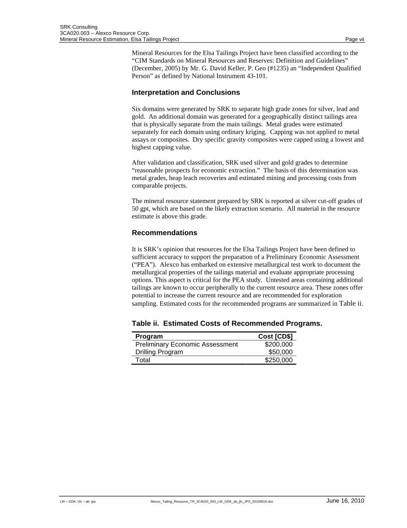
Mineral Resources for the Elsa Tailings Project have been classified according to the “CIM Standards on Mineral Resources and Reserves: Definition and Guidelines” (December, 2005) by Mr. G. David Keller, P. Geo (#1235) an “Independent Qualified Person” as defined by National Instrument 43-101. Interpretation and Conclusions Six domains were generated by SRK to separate high grade zones for silver, lead and gold. An additional domain was generated for a geographically distinct tailings area that is physically separate from the main tailings. Metal grades were estimated separately for each domain using ordinary kriging. Capping was not applied to metal assays or composites. Dry specific gravity composites were capped using a lowest and highest capping value. After validation and classification, SRK used silver and gold grades to determine “reasonable prospects for economic extraction.” The basis of this determination was metal grades, heap leach recoveries and estimated mining and processing costs from comparable projects. The mineral resource statement prepared by SRK is reported at silver cut-off grades of 50 gpt, which are based on the likely extraction scenario. All material in the resource estimate is above this grade. Recommendations It is SRK’s opinion that resources for the Elsa Tailings Project have been defined to sufficient accuracy to support the preparation of a Preliminary Economic Assessment (“PEA”). Alexco has embarked on extensive metallurgical test work to document the metallurgical properties of the tailings material and evaluate appropriate processing options. This aspect is critical for the PEA study. Untested areas containing additional tailings are known to occur peripherally to the current resource area. These zones offer potential to increase the current resource and are recommended for exploration sampling. Estimated costs for the recommended programs are summarized in Table ii.
Table ii. Estimated Costs of Recommended Programs.
Program Cost [CD$] Preliminary Economic Assessment $200,000 Drilling Program $50,000 Total $250,000
SRK Consulting 3CA020.003 – Alexco Resource Corp. Mineral Resource Estimation, Elsa Tailings Project Page viii
LW – GDK / jfc – ab -jps Alexco_Tailing_Resource_TR_3CA020_003_LW_GDK_ab_jfc_JPS_20100616.doc June 16, 2010
Table of Contents
Executive Summary ................................................................. ii Introduction .................................................................................... ii Property Description and Agreements ........................................... ii Location Access and Physiography ............................................... iii History ............................................................................................ iii Regional and Local Geology ......................................................... iv Deposit Type and Mineralization ................................................... iv Drilling ........................................................................................... iv Sampling Method, Approach and Analyses ................................... v Data Verification ............................................................................. v Mineral Resource Estimation ......................................................... v Mineral Resources Statement ....................................................... vi Interpretation and Conclusions ..................................................... vii Recommendations ........................................................................ vii
Table of Contents ................................................................. viii
List of Tables ........................................................................... xi
List of Figures ......................................................................... xi
1 Introduction ........................................................................ 1 1.1 Qualification of SRK............................................................... 1 1.2 Scope of Work ....................................................................... 2 1.3 Basis of the Technical Report ................................................ 2 1.4 Site Visit ................................................................................. 3
2 Reliance on other Experts and Declaration ..................... 4
3 Property Description and Location ................................... 5 3.1 Land Tenement ..................................................................... 5 3.2 Underlying Agreements ......................................................... 5 3.3 Royalties ................................................................................ 7
4 Accessibility, Climate, Local Resources, Infrastructure and Physiography .............................................................. 9 4.1 Accessibility ........................................................................... 9 4.2 Local Resources .................................................................... 9 4.3 Climate................................................................................... 9 4.4 Physiography ....................................................................... 10
5 History ............................................................................... 13 5.1 District History...................................................................... 13 5.2 Elsa Tailings History ............................................................ 14
6 Geological Setting ............................................................ 16 6.1 Background Regional Geology ............................................ 16 6.2 Background Property Geology ............................................. 18 6.3 Tailings Property Geology ................................................... 20
7 Deposit Types ................................................................... 21
SRK Consulting 3CA020.003 – Alexco Resource Corp. Mineral Resource Estimation, Elsa Tailings Project Page ix
LW – GDK / jfc – ab -jps Alexco_Tailing_Resource_TR_3CA020_003_LW_GDK_ab_jfc_JPS_20100616.doc June 16, 2010
8 Mineralization ................................................................... 22 8.1 Tailings Composition ........................................................... 22
9 Exploration ........................................................................ 24
10 Drilling ............................................................................... 25 10.1 Introduction .......................................................................... 25 10.2 Drilling Procedures .............................................................. 25
10.2.1 UKHM Drilling ..................................................................... 25 10.2.2 Alexco Drilling .................................................................... 26
10.3 Collar Survey ....................................................................... 27
11 Sampling Approach and Methodology ........................... 29
12 Sample Preparation, Analyses and Security .................. 30 12.1.1 Sample Preparation and Analyses ..................................... 30 12.1.2 Analytical Quality Control Measures .................................. 30 12.1.3 Sampling Bias .................................................................... 31 12.1.4 Specific Gravity Data .......................................................... 31
13 Data Verification ............................................................... 32
14 Adjacent Properties ......................................................... 33
15 Mineral Processing and Metallurgical Testing ............... 34 15.1 Introduction .......................................................................... 34 15.2 Summary of Metallurgical Test Work ................................... 34 15.3 Sample Composition............................................................ 34 15.4 Cyanide Shake Tests........................................................... 34 15.5 Bottle Roll Tests ................................................................... 34 15.6 Column Leach Tests ............................................................ 35
16 Mineral Resource and Mineral Reserve Estimates ........ 36 16.1 Introduction .......................................................................... 36 16.2 Resource Data ..................................................................... 36 16.3 Solid Body Modelling ........................................................... 37 16.4 Domaining............................................................................ 37 16.5 Statistical Analysis and Compositing ................................... 39
16.5.1 Assays ................................................................................ 39 16.5.2 Specific Gravity .................................................................. 41
16.6 Variography ......................................................................... 41 16.7 Block Model Parameters ...................................................... 42 16.8 Grade Estimation ................................................................. 43 16.9 Estimation Validation ........................................................... 46 16.10 Mineral Resource Classification ................................ 46 16.11 Mineral Resources Statement ................................... 47
17 Other Relevant Data ......................................................... 49
18 Interpretation and Conclusions ...................................... 50
19 Recommendations ........................................................... 52
20 References ........................................................................ 53
APPENDIX A ........................................................................... 54
APPENDIX B ........................................................................... 66
SRK Consulting 3CA020.003 – Alexco Resource Corp. Mineral Resource Estimation, Elsa Tailings Project Page x
LW – GDK / jfc – ab -jps Alexco_Tailing_Resource_TR_3CA020_003_LW_GDK_ab_jfc_JPS_20100616.doc June 16, 2010
APPENDIX C ........................................................................... 68
APPENDIX D ........................................................................... 73
SRK Consulting 3CA020.003 – Alexco Resource Corp. Mineral Resource Estimation, Elsa Tailings Project Page xi
LW – GDK / jfc – ab -jps Alexco_Tailing_Resource_TR_3CA020_003_LW_GDK_ab_jfc_JPS_20100616.doc June 16, 2010
List of Tables
Table i. Mineral Resource Statement* for the Elsa Tailings Project, SRK Consulting, May 6, 2010. ............................................ vi
Table ii. Estimated Costs of Recommended Programs. .................... vii
Table 1. Summary of Drilling on the Elsa Tailings Project. ............... 25
Table 2. Preliminary Average Recoveries and Chemical Consumptions. .................................................................... 35
Table 3. Summary Statistics for Raw Assays. .................................. 39
Table 4. Elsa Tailings Block Model. .................................................. 43
Table 5. Mineral Resource Statement* for the Elsa Tailings Project, SRK Consulting, May 6, 2010. ........................................... 48
Table 6. Estimated Costs of Recommended Programs. ................... 52
List of Figures
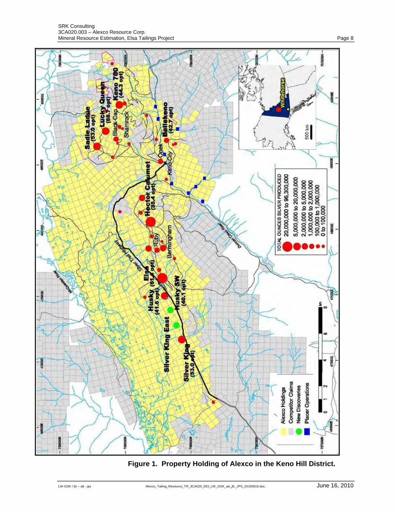
Figure 1. Property Holding of Alexco in the Keno Hill District. ............ 8
Figure 2. Location and Drainage of Elsa Tailings. ............................ 11
Figure 3. Tailings Impoundment Area, Looking Northwest (upper), Looking Northeast (lower). ................................................. 12
Figure 4. Porcupine Creek Bed Tailings in the Vicinity of Proximal Domain. .............................................................................. 12
Figure 5. General Geology of the Selwyn Basin Area. Image from Dusel-Bacon et al. (2002). .................................................. 17
Figure 6. Local Geology of the Keno Hill Camp. (Image Modified from a Geological Survey of Canada map). ................................... 19
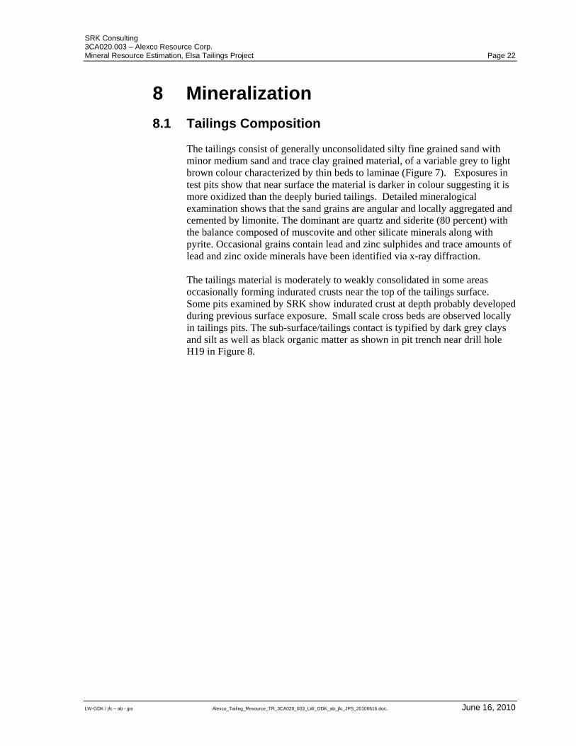
Figure 7. Tailings trench showing indurated crust and very thin to fine laminae, organics at base. .................................................. 23
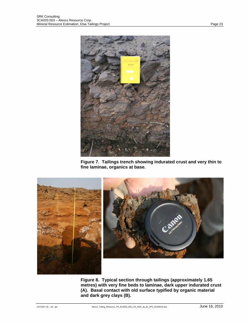
Figure 8. Typical section through tailings (approximately 1.65 metres) with very fine beds to laminae, dark upper indurated crust (A). Basal contact with old surface typified by organic material and dark grey clays (B). ............................................................. 23
Figure 9. Typical Sonic Drill Core, Hole number P113. .................... 27
Figure 10. Elsa Tailings and 2009 Sonic Drill Holes. ........................ 28
Figure 11. Location of High Grade Domains and Proximal Domain. 38
Figure 12. Sample Interval Length Analysis. .................................... 40
Figure 13. Cumulative Frequency Plot for Silver Composites, AGLG Domain. .............................................................................. 40
SRK Consulting 3CA020.003 – Alexco Resource Corp. Mineral Resource Estimation, Elsa Tailings Project Page xii
LW – GDK / jfc – ab -jps Alexco_Tailing_Resource_TR_3CA020_003_LW_GDK_ab_jfc_JPS_20100616.doc June 16, 2010
Figure 14. Silver Variogram for AGLG Domain................................. 42
Figure 15. Typical Block Model Cross-Section, Silver Grades (vertical exaggeration of 15, spaces between topography line (brown) and block model is caused blocks being slight off of the section line). ....................................................................... 44
Figure 16. Typical Block Model Cross-Section, Gold Grades (vertical exaggeration of 15, spaces between topography line (brown) and block model is caused blocks being slight off of the section line). ....................................................................... 45
Figure 17. Three Dimensional View of Silver Grade Block Model (black squares are drill hole collars). ............................................. 46
Figure 18. Grade and Tonnage Plot for Elsa Tailings Deposit.......... 48
Figure 19. Tailings Areas Not Drilled in the 2009 Program (yellow). 51
SRK Consulting 3CA020.003 – Alexco Resource Corp. Mineral Resource Estimation, Elsa Tailings Project Page 1
LW-GDK / jfc – ab - jps Alexco_Tailing_Resource_TR_3CA020_003_LW_GDK_ab_jfc_JPS_20100616.doc, June 16, 2010
1 Introduction The Elsa Tailings Project is an advanced project delineating the mineral potential of historical tailings from the former United Keno Hill Mines (“UKHM”) mill located in the town of Elsa, Yukon. The Elsa tailings are impounded on the south-eastern slopes of the McQuesten River valley approximately 400 metres from the UKHM mill. . Milling operations at Elsa started in the 1930s and continued almost continuously until 1988. Historical production records indicate that approximately 4,050,000 tons of tailings were deposited at the Elsa site. Most of this material was allowed to run out onto the flank of the adjacent valley without engineered impoundment. The original ground surface was covered with small trees, bush and a vegetative mat of moss, all of which was eventually covered by the tailings. In 1958 a dam was constructed to prevent tailing-laden water from moving to the west along the Flat Creek drainage. At the same time the tailings discharge point was moved from Porcupine Creek to a point further east, forcing the tailings to accumulate behind the dam. Over time, two additional dams were constructed below the first dam to control run off across older tailings. Historical resource estimates on the Elsa Tailings Project were made by UKHM in 1970 and 1988. On June 29, 2009 SRK Consulting (Canada) Inc. (“SRK”) was commissioned by Alexco Resource Corporation (“Alexco”) to prepare a mineral resource estimate for the Elsa Tailings Project. The mineral resource statement reported herein represents a first evaluation of mineral resources prepared for the Elsa Tailings Project for Alexco. This technical report documents the mineral resource estimate for the Elsa Tailings Project. It was prepared following the guidelines of the Canadian Securities Administrators National Instrument 43-101 and Form 43-101F1, and in conformity with generally accepted CIM “Estimation of Mineral Resources and Mineral Reserves Best Practice Guidelines.”
1.1 Qualification of SRK The SRK Group comprises over 800 professionals, offering expertise in a wide range of resource engineering disciplines. The SRK Group’s independence is ensured by the fact that it holds no equity in any project and that its ownership rests solely with its staff. This permits SRK to provide its clients with conflict-free and objective recommendations on crucial judgment issues. SRK has a demonstrated track record in undertaking independent assessments of Mineral Resources and Mineral Reserves, project evaluations and audits, technical reports and independent feasibility evaluations to bankable standards on behalf of exploration and mining companies and financial institutions worldwide. The SRK Group has also worked with a large number of major international mining companies and their projects, providing mining industry consultancy service inputs.
SRK Consulting 3CA020.003 – Alexco Resource Corp. Mineral Resource Estimation, Elsa Tailings Project Page 2
LW-GDK / jfc – ab - jps Alexco_Tailing_Resource_TR_3CA020_003_LW_GDK_ab_jfc_JPS_20100616.doc, June 16, 2010
This technical report was compiled by Mr. David Keller, P.Geo. (APGO#1235) and Dr. Lars Weiershäuser, P.Geo (APGO#1504). Mr. Keller is a Principal Resource Geologist with SRK and has been employed by SRK since 2004. He has been engaged in mineral deposit evaluations and resource estimates since 1986. Mr. Keller visited the property from August 5 to 9, 2009. Dr. Weiershäuser is a consulting geologist with SRK and has been employed by SRK since February 2007. Dr. Weiershäuser has not visited the property.
1.2 Scope of Work The scope of work, as outlined in a memo to Alexco dated July 17, 2009 includes a review of previous resource estimates, recommendations for a new drilling and sampling program, estimation of mineral resources based on the 2009 Alexco drilling campaign and the preparation of an independent technical report in compliance with National Instrument 43-101 and Form 43-101F1 guidelines. This work would typically involve an assessment of the following: Audit of the new exploration drilling results; Validation of new wireframes; Geostatistical analysis and variography; Mineral resource estimation; Validation of estimates; and Recommendations for additional work.
1.3 Basis of the Technical Report This technical report is based on information collected by SRK during site visits and created by SRK during the work relating to this assignment. Additional information was provided by Alexco or obtained from public sources. SRK has no reason to doubt the reliability of the information provided by Alexco. SRK conducted certain verifications of exploration data from archived files maintained by Alexco. The information contained herein is based on information believed to be reliable. This technical report is based on the following sources of information: Discussions with Alexco exploration personnel; Personal inspection of the Elsa Tailings; Audit of exploration work conducted by Alexco; and Additional information obtained from historical reports and internal
company reports.
SRK Consulting 3CA020.003 – Alexco Resource Corp. Mineral Resource Estimation, Elsa Tailings Project Page 3
LW-GDK / jfc – ab - jps Alexco_Tailing_Resource_TR_3CA020_003_LW_GDK_ab_jfc_JPS_20100616.doc, June 16, 2010
1.4 Site Visit In compliance with National Instrument 43-101 guidelines, Mr. G. David Keller visited the Alexco site at Elsa from August 5 to August 9, 2009 in conjunction with visits to two concurrent Alexco projects. Mr. Keller dedicated time to the Elsa Project from August 7 to August 9, 2010. The purpose of the visit was to: Examine tailings impoundment area and tailings material; Examine open trenches and cuts in tailings impoundment area; Review and discuss previous drilling and sampling data; and Formulate a drilling and sampling strategy with Alexco to evaluate mineral
resources for the project. SRK completed the site visit before the Alexco sonic drilling program started and did not witness the execution of the drilling and sampling program. SRK was involved in the planning stage for the drilling program and discussed the program extensively with Alexco staff. SRK examined core photos and data from the drilling program.
SRK Consulting 3CA020.003 – Alexco Resource Corp. Mineral Resource Estimation, Elsa Tailings Project Page 4
LW-GDK / jfc – ab - jps Alexco_Tailing_Resource_TR_3CA020_003_LW_GDK_ab_jfc_JPS_20100616.doc, June 16, 2010
2 Reliance on other Experts and Declaration SRK’s opinion contained herein and effective June 16, 2010, is based on information provided to SRK by Alexco throughout the course of SRK’s investigations, which in turn reflect various technical and economic conditions at the time of writing. Given the nature of the mining business, these conditions can change significantly over relatively short periods of time. Consequently actual results may be significantly more or less favourable. This report includes technical information, which requires subsequent calculations to derive sub-totals, totals and weighted averages. Such calculations inherently involve a degree of rounding and consequently introduce a margin of error. Where these occur, SRK does not consider them to be material. SRK is not an insider, associate or an affiliate of Alexco and neither SRK nor any affiliate has acted as advisor to Alexco or its affiliates in connection with this project. The results of the technical review by SRK are not dependent on any prior agreements concerning the conclusions to be reached, nor are there any undisclosed understandings concerning any future business dealings. The Elsa Tailings Project is located within the historic Keno Hill mining camp. Minimal new surface disturbances have occurred within the project area arising from surface drilling. Potential environmental liabilities associated with the Elsa Tailings Project were excluded from the work program. As such, no verification was conducted by SRK and no opinion is expressed regarding the environmental aspect of this project. The Elsa Tailings Project is part of a larger property which comprises two Crown grants, 717 mining leases, six surface leases, three fee simple lots and 864 unsurveyed mineral claims (copies presented in Appendix A) covering an aggregate area of approximately 150 square kilometres (“km2”). Alexco informed SRK that the titles are in good standing and that as of October, 2009, they are wholly owned by Alexco free of liens. For the purpose of this assignment SRK has not verified the status of the mining titles with the Government authorities. SRK was informed by Alexco that there are no known litigations potentially affecting the Elsa Tailings Project.
SRK Consulting 3CA020.003 – Alexco Resource Corp. Mineral Resource Estimation, Elsa Tailings Project Page 5
LW-GDK / jfc – ab - jps Alexco_Tailing_Resource_TR_3CA020_003_LW_GDK_ab_jfc_JPS_20100616.doc, June 16, 2010
3 Property Description and Location The Elsa Tailings Project is located within Alexco’s Keno property situated in the Mayo Mining District approximately 450 kilometres north of Whitehorse, Yukon. The area is covered by NTS map sheets 105M/13 and 105M/14. Access to the property is via a paved, two-lane highway from Whitehorse to Mayo (407 kilometres) and an all-weather gravel road northeast from Mayo to Elsa (45 kilometres) – a total distance of 452 kilometres. The tailings are impounded on the south-eastern slope of the broad McQuesten River valley centred along the Flat and Porcupine Creek drainages and are located approximately 400 metres northwest of the abandoned town of Elsa.
3.1 Land Tenement The land under the control of Alexco comprises 717 surveyed quartz mining leases, 864 unsurveyed quartz mining claims, and two crown grants. The total area approximates 24,300 hectares outlined in Figure 1. Certain UKHM claims may be subject to unknown or unregistered royalties and/or agreements. Quartz mining leases provide mineral title to the area occupied by the tailings and are part of a large land package controlled by Alexco through its subsidiaries, Elsa Reclamation and Development Co. (“ERDC”) and Alexco Keno Hill Mining Corp. The tailings are located on Quartz Leases: Orchid 1, 3, 15, 26, 31 & 37; Betty and Mud.
3.2 Underlying Agreements Alexco’s rights to much of the Keno Hill property are held through ERDC, a wholly owned subsidiary. In June 2005, PriceWaterhouseCoopers LLP (“PWC”), a court appointed interim receiver and receiver-manager of United Keno Hill Mines Limited and UKH Minerals Limited (collectively “UKHM”), selected Alexco as the preferred purchaser of the assets of UKHM. In February 2006, following negotiation of a Subsidiary Agreement between the Government of Canada, the Government of Yukon, and Alexco, the Supreme Court of Yukon approved the purchase of the assets of UKHM by Alexco through its wholly owned subsidiary, ERDC. The UKHM assets comprised two Crown Grants, 674 mining leases, 289 mineral claims, an ore concentration plant, various buildings and equipment, as well as partial ownership interest in three mining leases, 36 mineral claims, in addition to a leasehold interest in one mineral claim. PWC and Alexco entered into an agreement (the “Purchase Agreement”) dated August 4, 2005, as amended November 2, 2005 and January 31, 2006. Alexco assigned the Purchase Agreement to its wholly owned subsidiary ERDC on February 6, 2006. In February 2006, following the negotiation of a Subsidiary Agreement between the Government of Canada, the Government of Yukon, and Alexco, the Supreme Court of Yukon approved the purchase of the assets of UKHM by ERDC. “Interim Closing” of the UKHM transaction was completed on April
SRK Consulting 3CA020.003 – Alexco Resource Corp. Mineral Resource Estimation, Elsa Tailings Project Page 6
LW-GDK / jfc – ab - jps Alexco_Tailing_Resource_TR_3CA020_003_LW_GDK_ab_jfc_JPS_20100616.doc, June 16, 2010
18, 2006. Alexco assumed responsibility for care and maintenance operations at the UKHM property. On the Interim Closing, among other things, Alexco: Deposited CD$10 M in trust to be used exclusively to fund ERDC’s
contribution to the cost of the reclamation of the pre-existing environmental liabilities of the UKHM property;
Obtained possession of the mineral claims and leases, titled property and crown grants of UKHM and the equipment on the UKHM properties for the purposes of contracted care and maintenance and exploration by ERDC of the UKHM property.
On November 30, 2006, Alexco terminated a contract with a local contractor and started conducting operations utilizing its own employees and equipment. Title to all UKHM assets was transferred to Alexco (“Final Closing”) in late November 2007, following the approval of a “Type B” Water License by the Yukon Water Board. A water licence is the main operating licence in the Yukon and is required in order to use water and to deposit waste in or near water. On January 24, 2008, Alexco applied for a “Type B” Water Licence covering its proposed underground exploration program at Bellekeno. Commercial production and processing cannot commence until a Type “A” Water Licence is obtained. Finally, previous environmental assessments of the property outlined the need for a comprehensive abandonment/reclamation plan, which was required by the historic operating water licence. UKHM submitted an abandonment plan in 1990; however, government regulatory agencies judged it deficient in several respects. Alexco is formulating an Existing State of Mine Closure Plan for the entire district as part of its agreements with the Governments. The quartz mining claims and leases currently owned by Alexco cover an aggregated area of approximately 24,300 ha, forming an east-northeast trending belt about 29 kilometres long and up to eight kilometres wide within the Keno Hill Mining District (Figure 4.2). The titles of the following land assets were transferred to Alexco after the issuance of a Type “B” Water Licence on 14 November 2007: 100 percent of 637 quartz mining leases, 2 Crown grants, and 85 quartz
mining claims; 50 percent of 3 quartz mining leases; 70 percent of 29 quartz mining claims; 65 percent of 7 quartz mining claims. All quartz mining leases have been legally surveyed whereas the quartz mining claims have not. In addition, in 2006 and 2007, 650399 BC Ltd., a wholly owned Alexco subsidiary staked 673 mineral claims (full size and fractional) adjacent to and contiguous with the UKHM property and purchased 36 quartz claims and 37 quartz mining leases from a third party. In 2008 and 2009, Alexco took four existing claims to lease, acquired an additional 18 claims from a third party, and amalgamated 55 additional existing bordering claims into the holdings. Mineral exploration at Keno Hill was initially permitted under the terms and conditions set out by the Yukon Government in the Class III Quartz Mining Land Use Permit – LQ00186, issued on July 5, 2006 and valid until July 4, 2011. Alexco subsequently obtained a Class IV Quartz Mining Land Use Permit – LQ00240 on June 17, 2008. The two permits were
SRK Consulting 3CA020.003 – Alexco Resource Corp. Mineral Resource Estimation, Elsa Tailings Project Page 7
LW-GDK / jfc – ab - jps Alexco_Tailing_Resource_TR_3CA020_003_LW_GDK_ab_jfc_JPS_20100616.doc, June 16, 2010
amalgamated on December 8, 2008 under #LQ00240 which is valid until December 16, 2018. Under the terms of a legal agreement with the Government of Canada and the Government of Yukon, Alexco is indemnified from any and all environmental liability that may be presented by the historic tailings. However, if Alexco were to nominate any part of the tailings as a production unit under the above agreement, responsibility for addressing water- related environmental liabilities would fall to Alexco.
3.3 Royalties Future production from the Keno Hill Silver District, including the Bellekeno Mine, is subject to a 1.5 percent NSR royalty, capped at CD$4.0 M, payable to the Government of Canada. This royalty is a condition of the Subsidiary Agreement. Payment of the royalty does not begin until all pre-production capital has been recouped plus an additional allowance for district exploration of approximately CD$6.2 M. Alexco and Silver Wheaton Corporation (“Silver Wheaton”) entered into an agreement on October 2, 2008 (the “Silver Purchase Agreement”) whereby 25 percent of all future silver production from the Keno Hill Silver District will be delivered to Silver Wheaton in exchange for a payment of US$3.90/oz as well as a payment by Silver Wheaton of US$50 M for use in the development and construction of the Bellekeno Mine.
SRK Consulting 3CA020.003 – Alexco Resource Corp. Mineral Resource Estimation, Elsa Tailings Project Page 8
LW-GDK / jfc – ab - jps Alexco_Tailing_Resource_TR_3CA020_003_LW_GDK_ab_jfc_JPS_20100616.doc, June 16, 2010
Figure 1. Property Holding of Alexco in the Keno Hill District.
SRK Consulting 3CA020.003 – Alexco Resource Corp. Mineral Resource Estimation, Elsa Tailings Project Page 9
LW-GDK / jfc – ab - jps Alexco_Tailing_Resource_TR_3CA020_003_LW_GDK_ab_jfc_JPS_20100616.doc, June 16, 2010
4 Accessibility, Climate, Local Resources, Infrastructure and Physiography
4.1 Accessibility The Elsa Tailings Project is included within the historic Keno Hill mining camp, located in central Yukon. The closest town is Mayo, located on the Stewart River, about 45 kilometres to the south. Mayo is accessible from Whitehorse via a 407 kilometres all weather road; the town is also serviced by Mayo airport, which is located just to the north. A gravel all-weather road leads from Mayo to the project areas. Historically, the mining camp was linked by river route to the outside world; since 1950, the all-weather highway, which was also used for transporting the ore, has been the main link. Gravelled tracks have been built on top of the tailings impoundment for monitoring and reclamation work.
4.2 Local Resources Three phase power is available in many parts of the district as well as limited telephone service. A large number of roads constructed for past mining operations are still serviceable. The old company town of Elsa, located toward the western end of the district, comprises several buildings that are currently being used for storage, maintenance work, and housing. A new camp and kitchen have been constructed at Flat Creek, just west of Elsa.
4.3 Climate The central Yukon is characterized by a sub-arctic continental climate with cold winters and warm summers. Average temperatures in the winter are between minus 15 and minus 20 degrees Celsius but can reach minus 60 degrees Celsius. The summers are moderately warm and in July average temperatures are around 15 degrees Celsius. Exploration and mining work can be carried out year-round. Because of its northern latitude, winter days are short; north-facing slopes experience 10 weeks without direct sunlight around the winter solstice. Conversely, summer days are very long, especially in early summer around the summer solstice. Annual precipitation averages 28 centimetres; half of this amount falls as snow, which starts to accumulate in October and remains on the ground into May or June.
SRK Consulting 3CA020.003 – Alexco Resource Corp. Mineral Resource Estimation, Elsa Tailings Project Page 10
LW-GDK / jfc – ab - jps Alexco_Tailing_Resource_TR_3CA020_003_LW_GDK_ab_jfc_JPS_20100616.doc, June 16, 2010
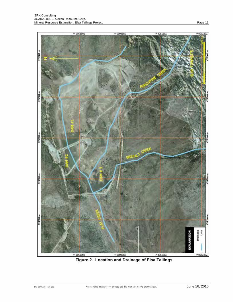
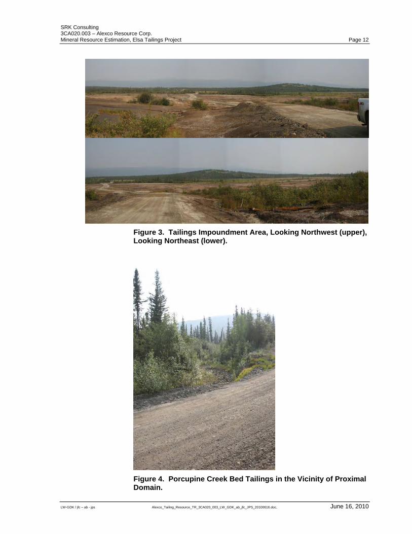
4.4 Physiography The Keno Hill area is characterized by rolling hills and mountains with relief up to 1200 metres. Slopes are generally gentle with steeper slopes on the north sides of Keno Hill and Sourdough Hill. The Elsa tailings are located on the southslope of the McQuesten valley, centred along the Flat and Porcupine Creek drainages as outlined in Figure 2. Valleys and slopes of the Keno Hill area are moderately to densely vegetated with grasses, shrubs and predominantly conifer forests. The tailings impoundment area is sparsely vegetated with occasional grass and shrubs with moderate to densely vegetated areas fringing the tailings area. Typical terrain of the tailings impoundment is presented in Figure 3 and Figure 4.
SRK Consulting 3CA020.003 – Alexco Resource Corp. Mineral Resource Estimation, Elsa Tailings Project Page 11
LW-GDK / jfc – ab - jps Alexco_Tailing_Resource_TR_3CA020_003_LW_GDK_ab_jfc_JPS_20100616.doc, June 16, 2010
Figure 2. Location and Drainage of Elsa Tailings.
SRK Consulting 3CA020.003 – Alexco Resource Corp. Mineral Resource Estimation, Elsa Tailings Project Page 12
LW-GDK / jfc – ab - jps Alexco_Tailing_Resource_TR_3CA020_003_LW_GDK_ab_jfc_JPS_20100616.doc, June 16, 2010
Figure 3. Tailings Impoundment Area, Looking Northwest (upper), Looking Northeast (lower).
Figure 4. Porcupine Creek Bed Tailings in the Vicinity of Proximal Domain.
SRK Consulting 3CA020.003 – Alexco Resource Corp. Mineral Resource Estimation, Elsa Tailings Project Page 13
LW-GDK / jfc – ab - jps Alexco_Tailing_Resource_TR_3CA020_003_LW_GDK_ab_jfc_JPS_20100616.doc, June 16, 2010
5 History
5.1 District History The history of the Keno Hill mining camp is well described in Cathro (2006); the information presented in this section draws heavily from that source. The Keno Hill mining camp area has a rich history of exploration and mining dating back to the beginning of the 1900s. Earliest prospectors had been working the area around Mayo for gold, especially after the Klondike gold rush of 1898. The first silver was found in 1901; however, interest was low due to the prospector’s interest in gold alone despite an assay from 1905 yielding more than 10 kilograms per ton (“kg/t”) silver. Small-scale mining commenced in 1913 with a first shipment of 55 tons of ore to a smelter in San Francisco. Due to the First World War, interest in the area had dwindled by 1917. In the early 1920s, the Treadwell Yukon Company Limited (“TYC”) became interested in the Keno Hill area and, under the leadership of Livingston Wernecke, acquired a number of claims and started mining. By 1941, in just under 18 years, when Wernecke died in an accident, TYC had produced 1,381 tons of silver and 43,772 tons of lead. More than half of that amount came from the Keno Hill mine. By this time a number of mines were in production, including: Sadie-Ladue, Lucky Queen, Silver King, Elsa, and Hector-Calumet; combined, about 85 percent of the camp’s production came from these mines. Interestingly, no zinc was recovered. Wernecke’s death in 1941 and the onset of the Second World War resulted in the closure of TYC’s properties. After the war a new company, Keno Hill Mining Company Ltd., (later United Keno Hill Mines Ltd.), purchased the idle TYC assets and resumed production. Almost immediately a major new vein was discovered by underground diamond drilling in the Hector Calumet mine, propelling United Keno Hill Mines (“UKHM”) to the forefront of Canadian silver production. The 1950s proved to be the most profitable period in the history of the camp, but by the early 1960s, minable reserves lagged production and considerable money was being spent in exploring for new deposits. A significant discovery was made at what would become the Husky mine in the late 1960s. In 1977 the first in a series of open pits was initiated primarily targeting low grade mineralization and pillars left near the surface of historic underground workings. Low silver prices, labor shortages and rising environmental costs forced UKHM to cease production in early 1989. Total production for the camp to 1989 is estimated to be 5.34 million short tons grading 40.1 ounces per ton Silver, 6.7 percent Lead and 4.1percent zinc (Cathro, 2006). Leasing of specific properties contributed a small amount of continued production through 1990.
SRK Consulting 3CA020.003 – Alexco Resource Corp. Mineral Resource Estimation, Elsa Tailings Project Page 14
LW-GDK / jfc – ab - jps Alexco_Tailing_Resource_TR_3CA020_003_LW_GDK_ab_jfc_JPS_20100616.doc, June 16, 2010
Between 1990 and 1998 The Dominion Mineral Resources and Sterling Frontier Properties Company of Canada Limited (“Dominion”), after acquiring a 32 percent interest in UKHM, carried out extensive reclamation, remediation and exploration work preparatory to reopening the camp. However, financing problems eventually forced Dominion to abandon its rights which reverted to UKHM. Environmental liabilities and site maintenance costs eventually drove UKHM into bankruptcy, resulting in the Federal Government of Canada inheriting the assets. In 2006 Alexco was selected as the prime contractor for environmental remediation work on the former UKHM property. Alexco was also allowed to purchase the property assets. Between 2006 and present Alexco carried out surface exploration throughout the district eventually concentrating on development of the historic Bellekeno mine area through extensive underground excavation and drilling.
5.2 Elsa Tailings History The files of UKHM contain several documents related to the Elsa Tailings impoundment, most detailing earlier efforts to estimate contained metals in the tailings. A summary of this information follows: Two mills have been sited at Elsa over the years; 1.) A flotation mill operated by the TYC during the late 1930s and early 1940s, which was refurbished in 1945, 2.) A new mill constructed after 1945 when the previous mill was destroyed by fire in 1949. The existing mill operated almost continuously from 1949 until 1988. Both mills produced a lead flotation concentrate and sometimes a zinc concentrate. A cyanide circuit to leach mill tails also operated during the years 1958 to 1966, 1968 and 1979 to 1981 as dictated by the prevailing economics of the time. It is estimated that in total approximately 4,050,000 tons of tailings were deposited at the Elsa site. Most of this material was allowed to run out onto the flank of the adjacent valley without engineered impoundment. The original ground surface was covered with small trees, brush and a vegetative mat of moss, all of which was eventually covered by the tailings. In 1958 a dam was constructed (Dam #1) to prevent tailings-laden water from moving to the west along the Flat Creek drainage. At the same time the tailings discharge point was moved from Porcupine Creek to a point further east, forcing the tailings to accumulate behind Dam #1. Over time, two additional dams were constructed below Dam #1 to control run off across older tailings (Figure 2). In 1970 a portion of the active tailings pond was sampled using an in-house percussion drill. The drilling covered the northerly part of the tailings where the depths of material were relatively modest ten feet (three metres) for the most part. Borehole spacing was approximately 200 feet (sixty metres). No detailed description of the drilling or sampling has been found in existing records. Assay certificates showing the results were also not found. Over the next eighteen years additional tailings were deposited in this area.
SRK Consulting 3CA020.003 – Alexco Resource Corp. Mineral Resource Estimation, Elsa Tailings Project Page 15
LW-GDK / jfc – ab - jps Alexco_Tailing_Resource_TR_3CA020_003_LW_GDK_ab_jfc_JPS_20100616.doc, June 16, 2010
In 1987 and 1988 the upper, thicker and generally higher grade portion of the tailings was sampled using a rotary drilling rig. Approximately 379 holes were drilled for a total of 5,396 feet (1,770 metres). Samples were collected over five -foot intervals and analyzed for silver, lead, zinc, and iron. Some samples were also analyzed for cadmium and non-sulphide lead.
Using the 1970 and 1987 to 1988 drilling results historical resources for the tailings were estimated at 4.05 million tons grading approximately 3.14 ounces per ton silver (108 gpt silver) of material. The reader is cautioned that this historical mineral resource estimate was prepared before the development of National Instrument 43-101 guidelines and the reported figures should not be relied upon. Metallurgical test work on tailings were undertaken by UKHM in 1988 and again in 1995 in a project jointly funded by two government entities and UKHM. The 1995 test work was summarized in a report by Hawthorne (1996). UKHM excavated pits at a number of points to collect additional samples for gravity separation, flotation and leach tests for the 1995 test work. Alexco excavated several test pits in the tailings area as part of an ongoing study of possible reclamation closure options (SRK, 2009).
SRK Consulting 3CA020.003 – Alexco Resource Corp. Mineral Resource Estimation, Elsa Tailings Project Page 16
LW-GDK / jfc – ab - jps Alexco_Tailing_Resource_TR_3CA020_003_LW_GDK_ab_jfc_JPS_20100616.doc, June 16, 2010
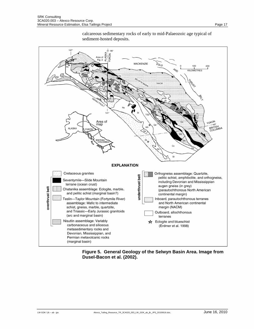
6 Geological Setting The Elsa Tailings are the net result of 85 years of mining activity in the Keno Hill district. As such a regional geology section is included in the report as background for the origin of tailings material.
6.1 Background Regional Geology The Keno Hill mining camp is located in the north western part of the Selwyn Basin in central Yukon Territory, Canada. The area is characterized by the Robert Service Thrust Sheet and the Tombstone Thrust Sheet; these thrust sheets are overlapping and trend north-westerly. The area is underlain by Upper Proterozoic to Mississippian rocks that were deposited in a shelf environment during the formation of the northern Cordilleran continental margin (Figure 5). A compressional regime that possibly existed during the Jurassic, but certainly during the Cretaceous, produced thrusts, folds and penetrative fabrics of various scales. Early large scale deformation (D1) produced recumbent folds, resulting in local structural thickening of strata. A second deformational event (D2; and possibly third, D3, Roots, 1997) produced gentle south westerly plunging syn- and anti-form pairs. Layering in these structures are axial planar to the D1 recumbent folds. The Robert Service Thrust Sheet is composed of Late Proterozoic to Cambrian sandstone, locally with interbedded limestone and argillite, a Cambrian to Middle Devonian succession of siltstone, limestone and chert, and Upper Devonian argillite, chert, and chert pebble conglomerate. The latter unit unconformably overlies the lower units. The Tombstone Thrust Sheet consists of Devonian phyllite, felsic meta-tuffs and metaclastic rocks, overlain by Carboniferous quartzite. This latter rock unit is locally thickened due to folding and or thrusting and hosts the mineralization of the Keno Hill camp. Intrusive rocks formed during four episodes of plutonism. Early Palaeozoic fine-grained diabase occurs as metre-scale dikes and sills in the Upper Proterozoic to Lower Cambrian rocks. During the Mid-Triassic, gabbros to diorites formed pods of various sizes, primarily in the Devonian and Mississippian rocks of the Tombstone Thrust Sheet. A third phase of plutonism took place around 92 million years ago in the early Cretaceous and resulted in widespread and voluminous Tombstone intrusions of commonly granitic to granodioritic composition. The youngest magmatic activity occurred around 65 million years ago in the Upper Cretaceous and resulted in the formation of peraluminous megacrystic potassium feldspar granite. In addition to the Keno Hill silver mining camp, where polymetallic veins were exploited, the area hosts a number of occurrences and showings of tungsten, copper, gold, lead, zinc, antimony and barite. Tin, tungsten, and molybdenum occurrences are possibly related to the suite of Cretaceous intrusions, whereas lead, zinc, and barite occur in stratiform
SRK Consulting 3CA020.003 – Alexco Resource Corp. Mineral Resource Estimation, Elsa Tailings Project Page 17
LW-GDK / jfc – ab - jps Alexco_Tailing_Resource_TR_3CA020_003_LW_GDK_ab_jfc_JPS_20100616.doc, June 16, 2010
calcareous sedimentary rocks of early to mid-Palaeozoic age typical of sediment-hosted deposits.
Figure 5. General Geology of the Selwyn Basin Area. Image from Dusel-Bacon et al. (2002).
SRK Consulting 3CA020.003 – Alexco Resource Corp. Mineral Resource Estimation, Elsa Tailings Project Page 18
LW-GDK / jfc – ab - jps Alexco_Tailing_Resource_TR_3CA020_003_LW_GDK_ab_jfc_JPS_20100616.doc, June 16, 2010
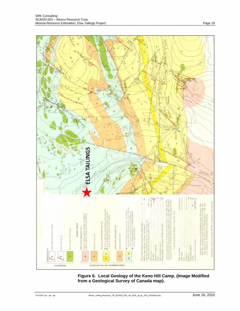
6.2 Background Property Geology The local geology is characterized by three meta-sedimentary rock units: Lower Schist, Central Quartzite, and Upper Schist (Figure 6). Individual layers are thought to be conformal and are metamorphosed to greenschist facies assemblages. Regional metamorphism is believed to have occurred in the Middle Cretaceous, about 105 million years ago. The Lower Schist is of Devonian to Mississippian age and is composed of graphitic, calcareous, and sericitic schist, thin and locally thick-bedded quartzite and minor greenstone of Middle Triassic age. The greenstone forms sills and/or boudins consisting of metadiorite and metagabbro. The sills and boudins form bodies up to one kilometre long and 30 metres thick. They occur primarily on Keno Hill. Weathering of the Lower Schist is pronounced and results in small silica fragments supported by a clay matrix. The fast weathering prevents outcrops from forming. The lower contact of this unit has been truncated by the Tombstone Thrust Fault. The Mississippian Central Quartzite, also known as the Keno Hill Quartzite, has a structural thickness of approximately 700 metres and consists of bedded and massive quartzite with minor schist and phyllite layers as well as greenstone horizons, which occur most commonly in the lower half of the Central Quartzite. The thickness of this unit is especially great in the Keno Hill area, which is likely due to the presence of a D1 fold nose and accompanied structural thickening in the Keno Hill area. Underground exposure has revealed tight isoclinal folding. Internal fracturing leaves the unit prone to weathering, resulting in the formation of felsenmeer down slope, where large slabs of quartzite accumulate. This unit is the most important host to the mineralization of the Keno Hill camp. A package of Cambrian quartz-mica schist, quartzite, graphitic schist, and minor limestone comprise the Upper Schist. The Robert Service Thrust Fault separates the Upper Schist from the younger Central Quartzite.
SRK Consulting 3CA020.003 – Alexco Resource Corp. Mineral Resource Estimation, Elsa Tailings Project Page 19
LW-GDK / jfc – ab - jps Alexco_Tailing_Resource_TR_3CA020_003_LW_GDK_ab_jfc_JPS_20100616.doc, June 16, 2010
Figure 6. Local Geology of the Keno Hill Camp. (Image Modified from a Geological Survey of Canada map).
SRK Consulting 3CA020.003 – Alexco Resource Corp. Mineral Resource Estimation, Elsa Tailings Project Page 20
LW-GDK / jfc – ab - jps Alexco_Tailing_Resource_TR_3CA020_003_LW_GDK_ab_jfc_JPS_20100616.doc, June 16, 2010
6.3 Tailings Property Geology The Elsa tailings lie on the south slope of the McQuesten valley. The rounded out shape of the valley can be attributed to at least one episode of glaciation that was followed by the deposition of glaciofluvial sands and gravels related to kame terraces. The glaciofluvial sands and gravels were deposited at higher valley elevations with till deposited at lower valley sides and valley bottoms. During the retreat of glacial ice, the McQuesten valley bottom was covered by a shallow lake resulting in the deposition of lacustrine silt. The lacustrine silt became increasingly organic and transitioned to peat as the glacial lake became in filled with sediments. Feed to the Elsa mill came solely from polymetallic vein deposits scattered throughout the Keno Hill district. Approximately 4.6 million tons of ore having an average head grade of 37.3 ounces. per ton silver, 6.4 percent lead and 4.4 percent zinc are documented to have been processed by the facility. Mill feed sources changed over time and the mineralogical character of the ore varied as a result. Production of near surface oxidized mineralization often contained ore minerals which were not readily amenable to flotation. A cyanide leach plant was employed to recover some of the silver not reporting to concentrates, but the economics associated with a fluctuating silver price forced the plant to run only intermittently. Zinc minerals occur erratically in the veins of Keno Hill and a zinc flotation concentrate was not always produced. From 1972 to 1988 zinc head grades averaged less than one percent and much of the metal was allowed to flow out in the tailings. Beginning in 1979 open pits became an important source of mill feed lowering the overall head grade and supplying a mixed oxide and sulphide ore.
SRK Consulting 3CA020.003 – Alexco Resource Corp. Mineral Resource Estimation, Elsa Tailings Project Page 21
LW-GDK / jfc – ab - jps Alexco_Tailing_Resource_TR_3CA020_003_LW_GDK_ab_jfc_JPS_20100616.doc, June 16, 2010
7 Deposit Types The Elsa Tailings cover an irregular area of approximately 130 hectares and range from 0.1 to over four metres in thickness. While the valley flank on which the tailings have been deposited is relatively smooth topographically, points of higher elevation occur as uncovered “islands” within the body of the tailing. The earliest site of tailings deposition appears to have been directly into Porcupine Creek with the material being mostly flushed downstream into Flat Creek. Beginning in 1946, tailings were directed away from the creeks proper producing small terraced accumulations immediately below the mill. Somewhat later a pipeline was constructed that discharged tailings further into the valley in the area between Porcupine and Flat Creek. An earthen dam (#1 Dam) was constructed in 1958 across upper Flat Creek and the tailings discharge line moved again, this time to the east forcing material to be deposited behind the dam. Ten major mines supplied feed to the Elsa Mill during its operation. Production from the 1930s, 40s, and 1950s was dominated by high-grade deposits such as Elsa mine and Hector-Calumet mine on Galena Hill. The 1960s saw a transition in ore sources with the reopening of the Silver King mine and discovery of the high-grade Husky deposit. The 1970s and 80s witnessed the demise of old producers and the introduction of lower grade material from open pits and smaller underground operations such as Ruby, No Cash and Keno 700.
SRK Consulting 3CA020.003 – Alexco Resource Corp. Mineral Resource Estimation, Elsa Tailings Project Page 22
LW-GDK / jfc – ab - jps Alexco_Tailing_Resource_TR_3CA020_003_LW_GDK_ab_jfc_JPS_20100616.doc, June 16, 2010
8 Mineralization
8.1 Tailings Composition The tailings consist of generally unconsolidated silty fine grained sand with minor medium sand and trace clay grained material, of a variable grey to light brown colour characterized by thin beds to laminae (Figure 7). Exposures in test pits show that near surface the material is darker in colour suggesting it is more oxidized than the deeply buried tailings. Detailed mineralogical examination shows that the sand grains are angular and locally aggregated and cemented by limonite. The dominant are quartz and siderite (80 percent) with the balance composed of muscovite and other silicate minerals along with pyrite. Occasional grains contain lead and zinc sulphides and trace amounts of lead and zinc oxide minerals have been identified via x-ray diffraction. The tailings material is moderately to weakly consolidated in some areas occasionally forming indurated crusts near the top of the tailings surface. Some pits examined by SRK show indurated crust at depth probably developed during previous surface exposure. Small scale cross beds are observed locally in tailings pits. The sub-surface/tailings contact is typified by dark grey clays and silt as well as black organic matter as shown in pit trench near drill hole H19 in Figure 8.
SRK Consulting 3CA020.003 – Alexco Resource Corp. Mineral Resource Estimation, Elsa Tailings Project Page 23
LW-GDK / jfc – ab - jps Alexco_Tailing_Resource_TR_3CA020_003_LW_GDK_ab_jfc_JPS_20100616.doc, June 16, 2010
Figure 7. Tailings trench showing indurated crust and very thin to fine laminae, organics at base.
Figure 8. Typical section through tailings (approximately 1.65 metres) with very fine beds to laminae, dark upper indurated crust (A). Basal contact with old surface typified by organic material and dark grey clays (B).
SRK Consulting 3CA020.003 – Alexco Resource Corp. Mineral Resource Estimation, Elsa Tailings Project Page 24
LW-GDK / jfc – ab - jps Alexco_Tailing_Resource_TR_3CA020_003_LW_GDK_ab_jfc_JPS_20100616.doc, June 16, 2010
9 Exploration No work that could be termed exploration was associated with the tailings project area.
SRK Consulting 3CA020.003 – Alexco Resource Corp. Mineral Resource Estimation, Elsa Tailings Project Page 25
LW-GDK / jfc – ab - jps Alexco_Tailing_Resource_TR_3CA020_003_LW_GDK_ab_jfc_JPS_20100616.doc, June 16, 2010
10 Drilling
10.1 Introduction The Elsa Tailings were drilled by UKHM and Alexco to delineate the geometry of the tailings, collect samples for assay and support evaluation of mineral resources. A summary of the drilling completed on the tailings is provided in Table 1.
Table 1. Summary of Drilling on the Elsa Tailings Project.
Company Period TypeNumberof Holes
Total Drilled Distance[metres]
UKHM 1970 Percussion 114 no dataUKHM 1987-1988 Tricone 379 1,770Alexco 2009 Sonic 283 910
10.2 Drilling Procedures
10.2.1 UKHM Drilling In 1970 UKHM carried out a percussion drilling program targeting the thicker northern portion of the tailings. A total of 114 vertical drill holes were drilled to an average depth of three metres. Drill hole spacing was reported at approximately 60 metres. Very little historical data is available for this drilling program. From 1987 to 1988 a second drilling program was completed by UKHM using a rotary drill for a total of 379 vertical holes (1,770 metres). This program covered the southern portion of the tailings impoundment that was not covered by drilling completed in 1970. Holes were spaced approximately 100 feet (30 metres) apart. Depths of tailings were determined by scrutinizing the drill cuttings for organic material and changes in sample grades. Drill cuttings for the entire drilled interval were sent for analysis. Limited assay certificates for this program are available. Alexco and SRK examined historical UKHM data and methodologies and concluded that drilling data is too unreliable to be used for resource evaluation and classification and does not conform to CIM best practice guidelines. The main concerns are centred on non-coring drilling methods used by UKHM. It is SRK’s opinion that the drilling methodologies used by UKHM probably resulted in: Sample contamination from the borehole wall ; and Poor accuracy in determining the subsurface tailings contact.
SRK Consulting 3CA020.003 – Alexco Resource Corp. Mineral Resource Estimation, Elsa Tailings Project Page 26
LW-GDK / jfc – ab - jps Alexco_Tailing_Resource_TR_3CA020_003_LW_GDK_ab_jfc_JPS_20100616.doc, June 16, 2010
10.2.2 Alexco Drilling
Alexco drilled 283 vertical sonic drill holes over the deposit in 2009 for 910 drilled metres. The Alexco drilling campaign consisted of drill holes spaced at 50 metres with lines orientated at an azimuth of 045 degrees (Figure 10). Average thickness of the drilled tailings is 2.3 metres ranging from a maximum thickness of 7.5 metres to a minimum of 0.2 metres. As none of the drill holes exceeded 7.5 metres in depth. No down hole surveys were deemed necessary. Alexco contracted Boart-Longyear of Edmonton, Alberta to complete the drilling program using a sonic drill mounted on a tracked carrier. A sonic drill uses simultaneous high-frequency vibrational and low-speed rotational motion accompanied by down-pressure to advance a flush thread drill pipe. As the drill string is advanced, material is pushed up into the pipe. The drill bit used by Boart-Longyear was 3.854 inches (9.79 centimetres) in diameter. No water or other fluids were used in the drilling process. Alexco drilling procedures consisted of drilling 5 foot (approximately 1.5 metre) runs. For each five foot run the drill string was removed from the hole in order to remove core. Once it had been established that the tailings had been completely drilled and the tailings/subsurface interface had been reached, drilling was halted. The base of the tailings was identified in most cases by a layer of organic material or visible changes in the oxidation and composition of the drill core. Core for each run was removed by vibrating the drill pipe so that core was slowly vibrated out of the pipe and in to a polyethylene sleeve that the drill helper pulled back as the sleeve was filled. When sample recovery proved difficult, the hole was abandoned and a new hole was started in close proximity to the original hole. In some instances portions of the sample would fall out of the open ended bit as the pipe was pulled up after each run, particularly if the material was water saturated. The lost portion of the sample was retrieved in the following drill run or a new hole was drilled with an extra long run to “sandwich” saturated sections between firmer stretches of tailings or drill material. Polyethylene sleeves containing tailings cores were opened in trays for logging and sampling at each drill site. The cores were initially examined to establish that the lower tailings contact had been drilled. All drill core was then logged and photographed. A typical core sample from drill hole P-13 is shown in Figure 9. Tailings core material is inherently difficult to handle as it is unconsolidated and, in some cases, is saturated with water. Because of the nature of the core material, challenges in core recovery, logging and sample collection can result from: Water saturated material becoming very fluid;
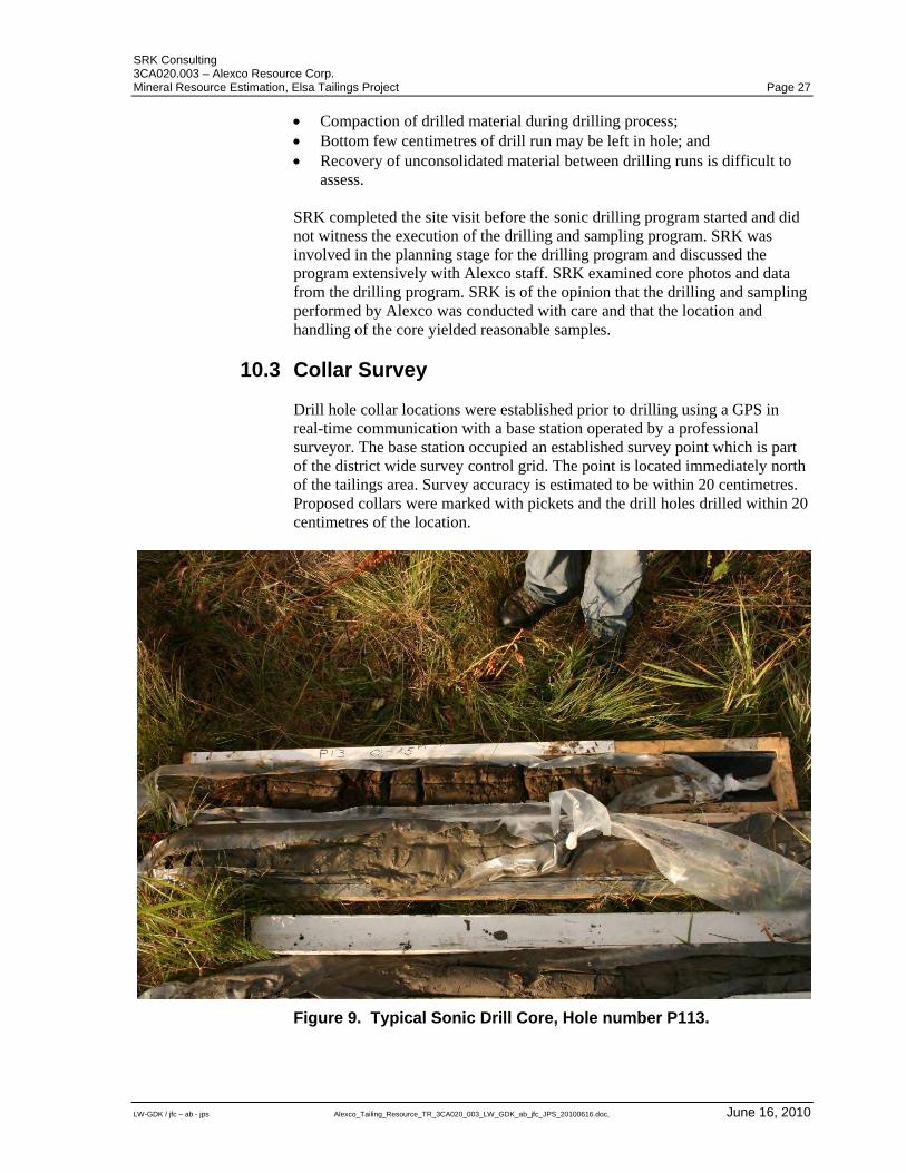
SRK Consulting 3CA020.003 – Alexco Resource Corp. Mineral Resource Estimation, Elsa Tailings Project Page 27
LW-GDK / jfc – ab - jps Alexco_Tailing_Resource_TR_3CA020_003_LW_GDK_ab_jfc_JPS_20100616.doc, June 16, 2010
Compaction of drilled material during drilling process; Bottom few centimetres of drill run may be left in hole; and Recovery of unconsolidated material between drilling runs is difficult to
assess. SRK completed the site visit before the sonic drilling program started and did not witness the execution of the drilling and sampling program. SRK was involved in the planning stage for the drilling program and discussed the program extensively with Alexco staff. SRK examined core photos and data from the drilling program. SRK is of the opinion that the drilling and sampling performed by Alexco was conducted with care and that the location and handling of the core yielded reasonable samples.
10.3 Collar Survey Drill hole collar locations were established prior to drilling using a GPS in real-time communication with a base station operated by a professional surveyor. The base station occupied an established survey point which is part of the district wide survey control grid. The point is located immediately north of the tailings area. Survey accuracy is estimated to be within 20 centimetres. Proposed collars were marked with pickets and the drill holes drilled within 20 centimetres of the location.
Figure 9. Typical Sonic Drill Core, Hole number P113.
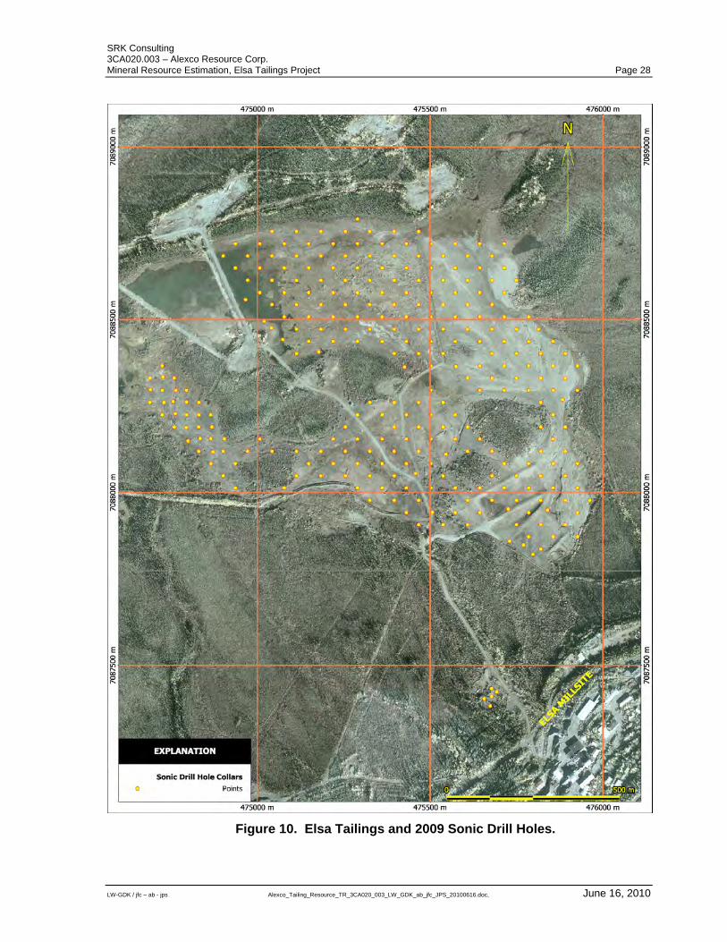
SRK Consulting 3CA020.003 – Alexco Resource Corp. Mineral Resource Estimation, Elsa Tailings Project Page 28
LW-GDK / jfc – ab - jps Alexco_Tailing_Resource_TR_3CA020_003_LW_GDK_ab_jfc_JPS_20100616.doc, June 16, 2010
Figure 10. Elsa Tailings and 2009 Sonic Drill Holes.
SRK Consulting 3CA020.003 – Alexco Resource Corp. Mineral Resource Estimation, Elsa Tailings Project Page 29
LW-GDK / jfc – ab - jps Alexco_Tailing_Resource_TR_3CA020_003_LW_GDK_ab_jfc_JPS_20100616.doc, June 16, 2010
11 Sampling Approach and Methodology In most cases 1.5 metre (five foot) drill runs were employed during drilling, but very short runs and runs up to 3.05 metres in length were combined in some instances to produce a continuous series of core samples. After logging, the entire core from each run interval was placed in a polyethylene sample bag securely closed with plastic zip ties. A sample tag with a number from a continuous series was placed in the bag and the outside of the bag was marked with the same number. Sample intervals were variable but the contact between tailings and the previous surface always acted as a sample boundary.
SRK Consulting 3CA020.003 – Alexco Resource Corp. Mineral Resource Estimation, Elsa Tailings Project Page 30
LW-GDK / jfc – ab - jps Alexco_Tailing_Resource_TR_3CA020_003_LW_GDK_ab_jfc_JPS_20100616.doc, June 16, 2010
12 Sample Preparation, Analyses and Security All polyethylene sample bags were packed in enclosed wooden crates with screws holding the lids in place. The crates were loaded into a covered semi-trailer and shipped to a motor freight company depot in Whitehorse, Yukon where they were transferred to commercial freight trucks destined for the ISO 9001 accredited ALS Chemex laboratory in North Vancouver, British Columbia.
12.1.1 Sample Preparation and Analyses Upon arrival at the ALS Chemex laboratory, each entire sample was weighed and dried in a high temperature oven at 120 degrees Celsius. Dry weight of the entire sample was then determined. The dried sample was then homogenized and split into three subset samples of one kilogram using a rotary splitter. One of the sample sub sets was then pulverized until 85 percent of the material was less than 75 micrometres. The initial analytical method applied was inductively coupled plasma-atomic emission spectrometry (Chemex code ME-ICP61 and ME-OG62) using a four acid digestion on a one gram sample charge. Thirty-three elements including silver, lead and zinc were analyzed using this method. Gold assays were analyzed using fire assay with atomic absorption spectrometry on a 30 gram sample charge (Chemex code Au-AA25). The ALS Chemex Vancouver laboratory is also accredited ISO 17025 by the Standards Council of Canada (Accreditation No. 579) for certain test procedures including the one used to assay the Elsa Tailings samples.
12.1.2 Analytical Quality Control Measures Quality control samples were placed systematically into the sample stream. Every 20 samples contained at least one blank sample, one standard of known value, and one request for a duplicate assay of the previous sample. The blank material consisted of ordinary masonry sand. The standard material used by Alexco is PB 131 produced by WCM Minerals of Burnaby, British Columbia. The reference material has been used successfully by Alexco previously as quality control sample for drilling programs at the Bellekeno deposit. Although the material has not been certified, WCM Minerals recommended values are: Lead 1.04 % Zinc 1.89 % Silver 262 gpt Although no gold values for PB 131 are recommended Alexco used this material as a gold reference material. Results of the Alexco quality control assay results are provided in Appendix A.
SRK Consulting 3CA020.003 – Alexco Resource Corp. Mineral Resource Estimation, Elsa Tailings Project Page 31
LW-GDK / jfc – ab - jps Alexco_Tailing_Resource_TR_3CA020_003_LW_GDK_ab_jfc_JPS_20100616.doc, June 16, 2010
12.1.3 Sampling Bias
In the opinion of SRK, the quality control data collected by Alexco is comprehensive and the assaying results delivered by ALS Chemex are reliable for the purpose of resource estimation.
12.1.4 Specific Gravity Data UKHM applied a blanket density of 1.6 to the tailings in their historic resource evaluation. There is no documentation detailing how they arrived at this value. Bulk density field measurements were determined in 2007 by SRK as part of a test pitting program. A standard metal cylinder designed for testing was inserted into near surface tailings and removed without compressing the material so that the entire cylinder was filled with tailings. The cylinder and tailings were then measured using a hand held spring scale. The wet density of the material was then calculated by subtracting the weight of the cylinder from the weight of the cylinder plus tailings to determine the weight of the tailings material. This weight was then divided by the volume of the cylinder to determine wet tailings density. Dry density was measured by visually estimating moisture content. The average measured density for tailings material was 1.9 grams per cubic centimetre. Alexco also conducted density measurements using 10 Shelby tubes, which were pushed into the tailings and removed by a drill rig. This method was problematic because poor core recovery affected nearly all samples. These results were not used for specific gravity investigations. The dry specific gravity for each of the 2009 sonic drill samples was measured for each of the assayed cores. Dry density was determined using the dry weight of the sample from the assay laboratory divided by the sampled interval volume. Sampled interval volume was calculated by interval length multiplied by the inside area of the core barrel which has an inside diameter of 0.0762 metres. Specific gravity results from this methodology ranged from 0.4 to 4.6 with a mean of 1.7. The range of specific gravity results is problematic; however, extensive analysis and review of results by SRK and Alexco did not identify specific sources of possible errors that invalidate the entirety of the results. Therefore, possible errors in measurements were attributed to the inherent difficulties of sampling unconsolidated material. It is SRK’s opinion that these specific gravity values are appropriate for use in estimating block specific gravity.
SRK Consulting 3CA020.003 – Alexco Resource Corp. Mineral Resource Estimation, Elsa Tailings Project Page 32
LW-GDK / jfc – ab - jps Alexco_Tailing_Resource_TR_3CA020_003_LW_GDK_ab_jfc_JPS_20100616.doc, June 16, 2010
13 Data Verification SRK compared 10 percent of the drill hole data assays to original assay certificates. No significant errors were found in the drill hole assay database. During the site visit, SRK examined three pits and briefly logged the pit walls. A summary of the logs are provided in Appendix B. The 2009 sonic drill hole program was completed after the SRK site visit. As such drill core was not examined or reviewed by SRK. As the entire drill core was sent for analysis, no core remained for subsequent examination. SRK did review Alexco drill core photos taken immediately before sampling.
SRK Consulting 3CA020.003 – Alexco Resource Corp. Mineral Resource Estimation, Elsa Tailings Project Page 33
LW-GDK / jfc – ab - jps Alexco_Tailing_Resource_TR_3CA020_003_LW_GDK_ab_jfc_JPS_20100616.doc, June 16, 2010
14 Adjacent Properties There are no adjacent properties considered relevant to this technical report.
SRK Consulting 3CA020.003 – Alexco Resource Corp. Mineral Resource Estimation, Elsa Tailings Project Page 34
LW-GDK / jfc – ab - jps Alexco_Tailing_Resource_TR_3CA020_003_LW_GDK_ab_jfc_JPS_20100616.doc, June 16, 2010
15 Mineral Processing and Metallurgical Testing
15.1 Introduction The following is based on a note from Kappes, Cassiday & Associates of Reno, Nevada dated June 3, 2010 that summarizes test work completed to date.
15.2 Summary of Metallurgical Test Work A series of metallurgical tests have been run on individual and composite samples of the Keno Hill Tailings material. The existing test work is preliminary in nature and is focused on identifying the best method for silver recovery. The results presented herein detail the recovery of silver and show that silver can be recovered using standard hydrometallurgical techniques. In late 2009, the laboratory facility of Kappes, Cassiday & Associates (“KCA”) in Reno, Nevada, received reject and pulp sample splits from ALS Chemex . The samples received were either pulp samples previously prepared by ALS Chemex or reject (drill cuttings) material. The samples received represented drill sampling of the Keno Hill Tailings located in the Yukon.
15.3 Sample Composition Alexco provided an aerial photograph of the tailings showing the drill hole identification numbers divided into four separate locations. The drill hole numbers were cross referenced to KCA sample numbers and four composite samples were created from the reject material.
15.4 Cyanide Shake Tests A portion of the 548 previously prepared pulp samples from ALS Chemex were used for cyanide shake tests. These shake test were conducted over a period of 24 hours at room temperature using a shaking table. The samples were then centrifuged and the solution was decanted and analyzed for silver utilizing flame atomic absorption spectrophotometer (FAAS) methods. Each sample was tested individually. For this report the results of the shake tests were averaged to generate an estimated overall recovery for the tailings material. The results are shown in Table 2.
15.5 Bottle Roll Tests A series of 40 bottle roll leach tests were conducted to determine the maximum amount of cyanide leachable silver. Tests were conducted at various cyanide concentrations and grind sizes typical of an agitated leach process. The average results are shown in Table 2.
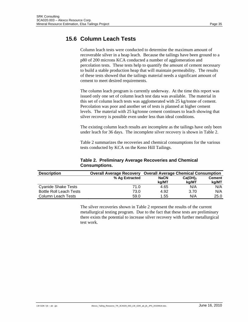
SRK Consulting 3CA020.003 – Alexco Resource Corp. Mineral Resource Estimation, Elsa Tailings Project Page 35
LW-GDK / jfc – ab - jps Alexco_Tailing_Resource_TR_3CA020_003_LW_GDK_ab_jfc_JPS_20100616.doc, June 16, 2010
15.6 Column Leach Tests Column leach tests were conducted to determine the maximum amount of recoverable silver in a heap leach. Because the tailings have been ground to a p80 of 200 microns KCA conducted a number of agglomeration and percolation tests. These tests help to quantify the amount of cement necessary to build a stable production heap that will maintain permeability. The results of these tests showed that the tailings material needs a significant amount of cement to meet desired requirements. The column leach program is currently underway. At the time this report was issued only one set of column leach test data was available. The material in this set of column leach tests was agglomerated with 25 kg/tonne of cement. Percolation was poor and another set of tests is planned at higher cement levels. The material with 25 kg/tonne cement continues to leach showing that silver recovery is possible even under less than ideal conditions. The existing column leach results are incomplete as the tailings have only been under leach for 36 days. The incomplete silver recovery is shown in Table 2. Table 2 summarizes the recoveries and chemical consumptions for the various tests conducted by KCA on the Keno Hill Tailings.
Table 2. Preliminary Average Recoveries and Chemical Consumptions.
Description Overall Average Recovery Overall Average Chemical Consumption % Ag Extracted NaCN
kg/MTCa(OH)2
kg/MT Cement
kg/MTCyanide Shake Tests 71.0 4.65 N/A N/ABottle Roll Leach Tests 73.0 4.92 3.70 N/AColumn Leach Tests 59.0 1.55 N/A 25.0
The silver recoveries shown in Table 2 represent the results of the current metallurgical testing program. Due to the fact that these tests are preliminary there exists the potential to increase silver recovery with further metallurgical test work.
SRK Consulting 3CA020.003 – Alexco Resource Corp. Mineral Resource Estimation, Elsa Tailings Project Page 36
LW-GDK / jfc – ab - jps Alexco_Tailing_Resource_TR_3CA020_003_LW_GDK_ab_jfc_JPS_20100616.doc, June 16, 2010
16 Mineral Resource and Mineral Reserve Estimates
16.1 Introduction In July 2009, SRK was commissioned by Alexco to prepare a mineral resource estimate for the Elsa Tailings Project. The resource estimate follows two historical resource estimates completed by UKHM. The resource estimation work was completed in Toronto by Mr. G. David Keller, P. Geo (APGO #1235) an “independent qualified person” as this term is defined in National Instrument 43-101. The mineral resource statement presented herein represents the first resource evaluation prepared for the Elsa Tailings Project for Alexco. This section describes the resource estimation methodology used by SRK and summarizes the key assumptions and parameters used to prepare the mineral resource model for the Elsa Tailings Project. In the opinion of SRK, the resource evaluation reported herein is a reasonable representation of the mineral resources found in the project at the current level of sampling. The mineral resources have been estimated in conformity with generally accepted CIM “Estimation of Mineral Resource and Mineral Reserves Best Practices” guidelines and are reported in accordance with Canadian Securities Administrators’ National Instrument 43-101. Mineral resources are not mineral reserves and do not have demonstrated economic viability. There is no certainty that all or any part of the mineral resource will be converted into mineral reserve.
16.2 Resource Data Data used to evaluate the mineral resources for the Elsa Tailings Project was provided by Alexco as an Access database containing drilling information for 283 drill holes from the 2009 sonic drilling program. No historical data was used for this project. The data set comprises 546 sampled intervals with silver, lead, zinc and gold assays for each interval. SRK has validated the data by: Checking the minimum and maximum values for each quality value field
and confirming those outside of expected ranges; Checking for gaps, overlaps and out of sequence intervals for both assay
and lithology tables; and Reviewing of analytical quality control data. It is SRK’s opinion that the drill hole database is appropriate for the estimation of mineral resources.
SRK Consulting 3CA020.003 – Alexco Resource Corp. Mineral Resource Estimation, Elsa Tailings Project Page 37
LW-GDK / jfc – ab - jps Alexco_Tailing_Resource_TR_3CA020_003_LW_GDK_ab_jfc_JPS_20100616.doc, June 16, 2010
16.3 Solid Body Modelling The tailings were modelled by Alexco. Alexco combined the upper and lower surfaces to generate a three dimensional wireframe model. High resolution topographic survey over the tailings and mapping tailings extents from drilling and air photo interpretation were used to generate an upper surface. The lower surface was generated from tailings/sub-surface contacts determined from sonic drilling data. SRK reviewed the Alexco wireframe model and considers it accurate and appropriate for the estimation of mineral resources.
16.4 Domaining SRK investigated the spatial distribution of assays and composites over the tailings area generating grade contours maps for gold, silver, zinc and lead. Based on these contour plots the main tailings area was subdivided into five domains. Contiguous high and low grade domains were generated for gold and silver-lead assays. As these domains represent distinct grade distributions the domains overlap and are not contiguous with each other metal domains. A separate domain comprising of the entire main tailings area was generated for variables that did not show distinct distributions of the tailings area. A sixth separate domain was created for an isolated area in the Porcupine Creek, in a gully above the main tailings area. This domain is discrete from all metal grades and specific gravity values defining other tailings domains. Domains generated by SRK are listed below: AGHG-high grade silver-lead; AGLG-low grade silver-lead; AUHG-high grade gold; AULG-low grade gold; ZINC-not domained, includes dry specific gravity; and Proximal-isolated tailings in gully above main tailings area. The High Grade, Low Grade, and Proximal domains are shown in Figure 11. The AGHG domain is delineated on the basis of silver grade contours and is situated on the southwest margin of the main tailings. The AGLG domain occupies all areas not covered by the AGHG domain. Both AGLG and AGHG domains were used to estimate silver and lead grades only. The AUHG domain is delineated by gold contours and occupies the southern to south-eastern margin of the main tailings. The AULG domain covers all areas not covered by AUHG. Zinc grades do not show any distinct grade zoning and therefore cover the entire main tailings area excluding the Proximal domain. Similarly, specific gravity data do not show any distinct zoning and therefore cover the entire tailings area (ZINC) excluding the proximal domain.
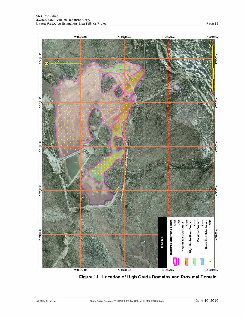
SRK Consulting 3CA020.003 – Alexco Resource Corp. Mineral Resource Estimation, Elsa Tailings Project Page 38
LW-GDK / jfc – ab - jps Alexco_Tailing_Resource_TR_3CA020_003_LW_GDK_ab_jfc_JPS_20100616.doc, June 16, 2010
Figure 11. Location of High Grade Domains and Proximal Domain.
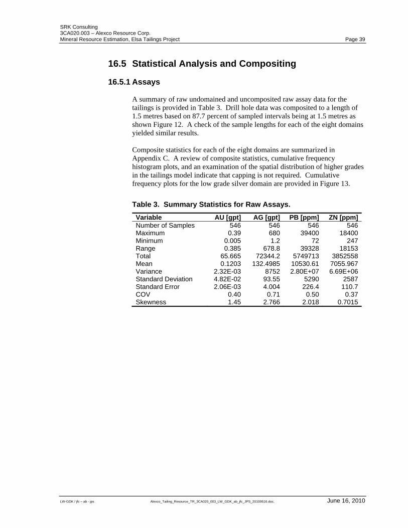
SRK Consulting 3CA020.003 – Alexco Resource Corp. Mineral Resource Estimation, Elsa Tailings Project Page 39
LW-GDK / jfc – ab - jps Alexco_Tailing_Resource_TR_3CA020_003_LW_GDK_ab_jfc_JPS_20100616.doc, June 16, 2010
16.5 Statistical Analysis and Compositing
16.5.1 Assays A summary of raw undomained and uncomposited raw assay data for the tailings is provided in Table 3. Drill hole data was composited to a length of 1.5 metres based on 87.7 percent of sampled intervals being at 1.5 metres as shown Figure 12. A check of the sample lengths for each of the eight domains yielded similar results. Composite statistics for each of the eight domains are summarized in Appendix C. A review of composite statistics, cumulative frequency histogram plots, and an examination of the spatial distribution of higher grades in the tailings model indicate that capping is not required. Cumulative frequency plots for the low grade silver domain are provided in Figure 13.
Table 3. Summary Statistics for Raw Assays.
Variable AU [gpt] AG [gpt] PB [ppm] ZN [ppm]Number of Samples 546 546 546 546Maximum 0.39 680 39400 18400Minimum 0.005 1.2 72 247Range 0.385 678.8 39328 18153Total 65.665 72344.2 5749713 3852558Mean 0.1203 132.4985 10530.61 7055.967Variance 2.32E-03 8752 2.80E+07 6.69E+06Standard Deviation 4.82E-02 93.55 5290 2587Standard Error 2.06E-03 4.004 226.4 110.7COV 0.40 0.71 0.50 0.37Skewness 1.45 2.766 2.018 0.7015
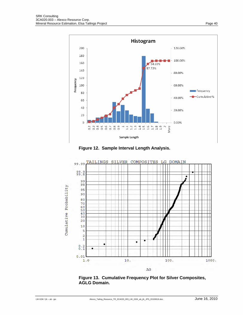
SRK Consulting 3CA020.003 – Alexco Resource Corp. Mineral Resource Estimation, Elsa Tailings Project Page 40
LW-GDK / jfc – ab - jps Alexco_Tailing_Resource_TR_3CA020_003_LW_GDK_ab_jfc_JPS_20100616.doc, June 16, 2010
Figure 12. Sample Interval Length Analysis.
Figure 13. Cumulative Frequency Plot for Silver Composites, AGLG Domain.
SRK Consulting 3CA020.003 – Alexco Resource Corp. Mineral Resource Estimation, Elsa Tailings Project Page 41
LW-GDK / jfc – ab - jps Alexco_Tailing_Resource_TR_3CA020_003_LW_GDK_ab_jfc_JPS_20100616.doc, June 16, 2010
16.5.2 Specific Gravity
Specific gravity measurements of dry sonic drilling material resulted in a wide range of results from 0.4 to 4.6. The wide range of values particularly above 4.0 and below 1.0 is of some concern and SRK undertook a number of analysis and examinations: Back calculation of lead and zinc grades to galena and zinc densities core
specific gravity; Scattergram plots of specific gravity values with assay grades and sample
length; Generation of specific gravity variograms with uncapped data and using
caps on low and high values; and Visual examination of spatial occurrence of high and low values in model. The above checks did not provide conclusive evidence that the specific gravity data was biased or that the data was seriously flawed. Based on this, SRK concludes that variations observed in the specific gravity data are due to the inherent challenges of sampling unconsolidated material but that the data is of sufficient quality for use in resource estimation. Summary statistics for specific gravity composites are provided by domain Appendix C. Drill hole specific gravity data were composited at 1.5 metres and capped using a low capping value of 0.75 (any values blow 0.75 where assigned a value of 0.75) and a high capping value of 4.0. No specific gravity values were capped in the Proximal domain but 11 values were capped (2 high caps and 9 low caps) in the ZINC domain.
16.6 Variography Variography was undertaken to characterize the spatial continuity of the metal grade data and specific gravity within each resource domain and to determine appropriate grade estimation ranges. Variogram models were developed for the AULG, AGLG, and ZINC domains only for the X and Y directions as there were insufficient composites for developing variograms in the Z direction. Variograms for gold were generated in the AULG domain, silver and lead in the AGLG domain, zinc dry specific gravity (DSG) in the ZINC domain. In developing the variograms, a nugget effect of about 20 percent was assumed for all variograms. Two structured variograms were developed for the three domains. The variogram for silver is presented in Figure 14. Other variograms are presented in Appendix D. Variograms were not generated for the high grade domains and the proximal domain as there were too few composites for analysis. AULG and AGLG variogram models were assumed for high grade gold (AUHG) and silver-lead domains (AGHG) as well as the Proximal domain. The DSG variogram was also assumed for Proximal domain specific gravity estimation. A summary of variogram model parameters is given in Appendix D.
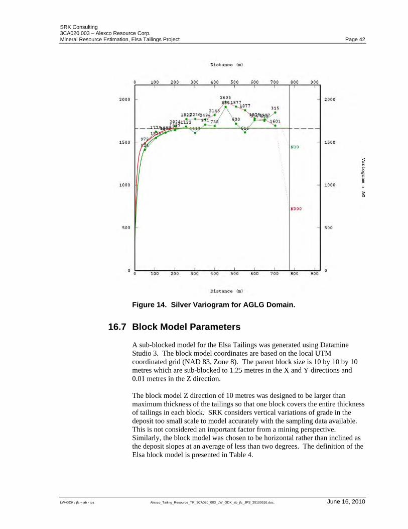
SRK Consulting 3CA020.003 – Alexco Resource Corp. Mineral Resource Estimation, Elsa Tailings Project Page 42
LW-GDK / jfc – ab - jps Alexco_Tailing_Resource_TR_3CA020_003_LW_GDK_ab_jfc_JPS_20100616.doc, June 16, 2010
Figure 14. Silver Variogram for AGLG Domain.
16.7 Block Model Parameters A sub-blocked model for the Elsa Tailings was generated using Datamine Studio 3. The block model coordinates are based on the local UTM coordinated grid (NAD 83, Zone 8). The parent block size is 10 by 10 by 10 metres which are sub-blocked to 1.25 metres in the X and Y directions and 0.01 metres in the Z direction. The block model Z direction of 10 metres was designed to be larger than maximum thickness of the tailings so that one block covers the entire thickness of tailings in each block. SRK considers vertical variations of grade in the deposit too small scale to model accurately with the sampling data available. This is not considered an important factor from a mining perspective. Similarly, the block model was chosen to be horizontal rather than inclined as the deposit slopes at an average of less than two degrees. The definition of the Elsa block model is presented in Table 4.
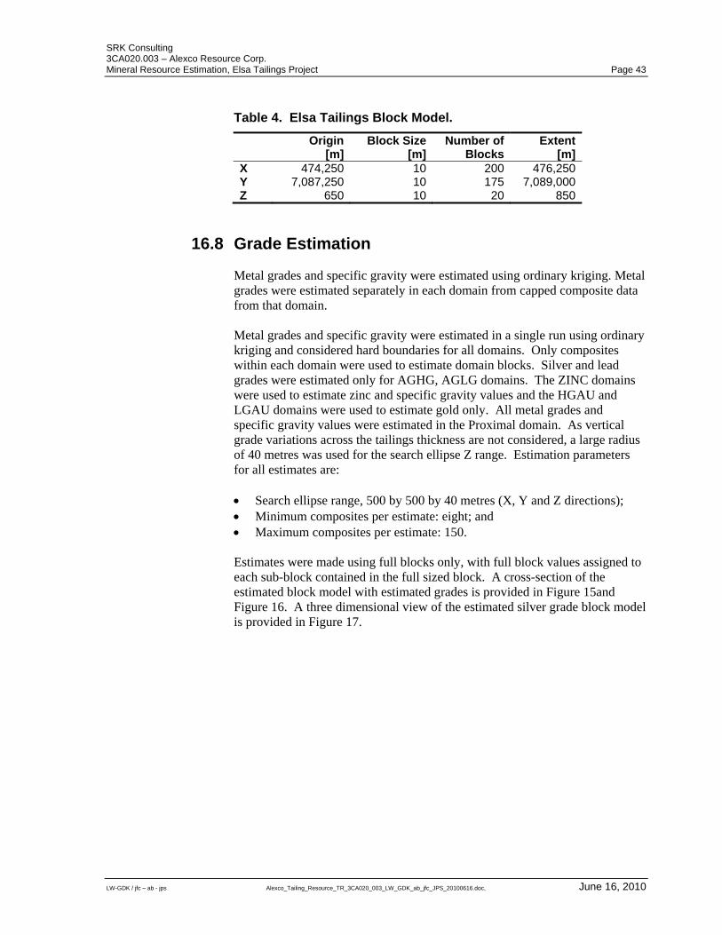
SRK Consulting 3CA020.003 – Alexco Resource Corp. Mineral Resource Estimation, Elsa Tailings Project Page 43
LW-GDK / jfc – ab - jps Alexco_Tailing_Resource_TR_3CA020_003_LW_GDK_ab_jfc_JPS_20100616.doc, June 16, 2010
Table 4. Elsa Tailings Block Model.
Origin
[m]Block Size
[m]Number of
BlocksExtent
[m] X 474,250 10 200 476,250 Y 7,087,250 10 175 7,089,000 Z 650 10 20 850
16.8 Grade Estimation Metal grades and specific gravity were estimated using ordinary kriging. Metal grades were estimated separately in each domain from capped composite data from that domain. Metal grades and specific gravity were estimated in a single run using ordinary kriging and considered hard boundaries for all domains. Only composites within each domain were used to estimate domain blocks. Silver and lead grades were estimated only for AGHG, AGLG domains. The ZINC domains were used to estimate zinc and specific gravity values and the HGAU and LGAU domains were used to estimate gold only. All metal grades and specific gravity values were estimated in the Proximal domain. As vertical grade variations across the tailings thickness are not considered, a large radius of 40 metres was used for the search ellipse Z range. Estimation parameters for all estimates are: Search ellipse range, 500 by 500 by 40 metres (X, Y and Z directions); Minimum composites per estimate: eight; and Maximum composites per estimate: 150. Estimates were made using full blocks only, with full block values assigned to each sub-block contained in the full sized block. A cross-section of the estimated block model with estimated grades is provided in Figure 15and Figure 16. A three dimensional view of the estimated silver grade block model is provided in Figure 17.
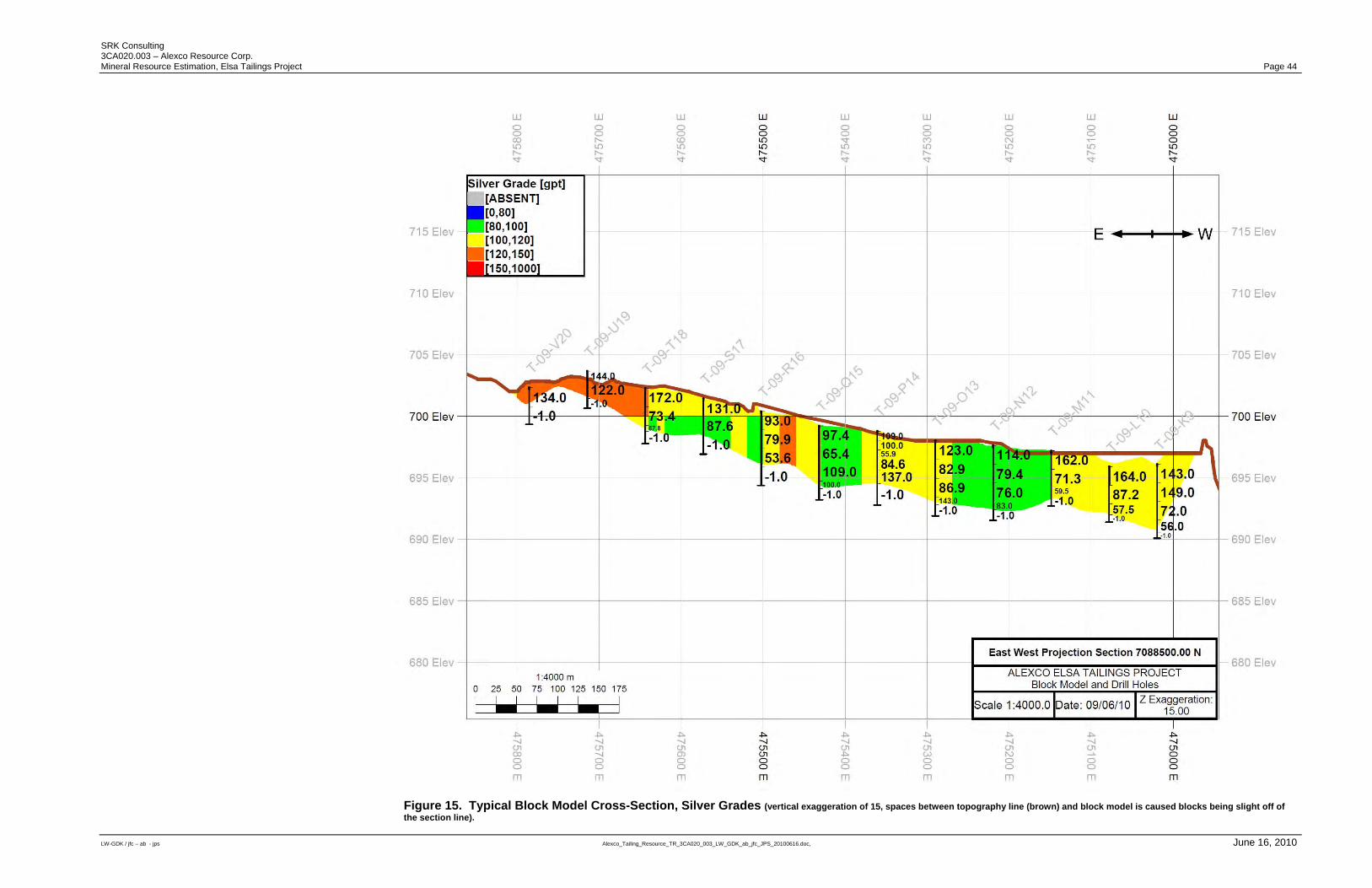
SRK Consulting 3CA020.003 – Alexco Resource Corp. Mineral Resource Estimation, Elsa Tailings Project Page 44
LW-GDK / jfc – ab - jps Alexco_Tailing_Resource_TR_3CA020_003_LW_GDK_ab_jfc_JPS_20100616.doc, June 16, 2010
Figure 15. Typical Block Model Cross-Section, Silver Grades (vertical exaggeration of 15, spaces between topography line (brown) and block model is caused blocks being slight off of the section line).
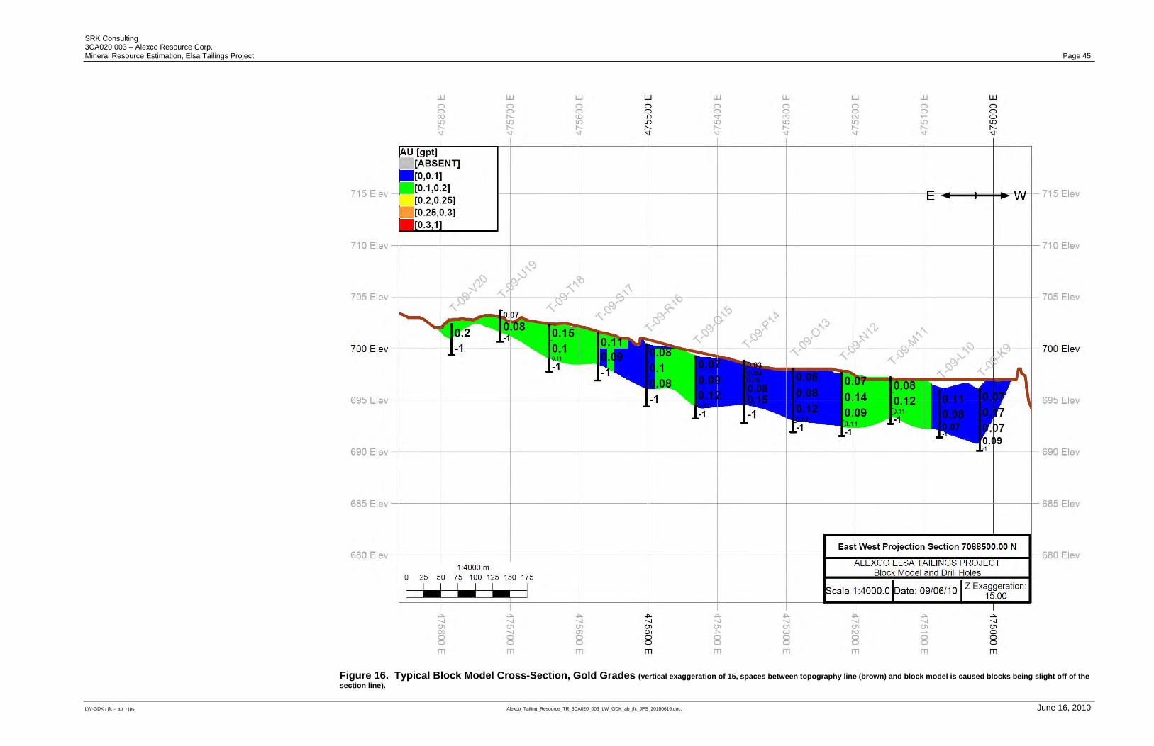
SRK Consulting 3CA020.003 – Alexco Resource Corp. Mineral Resource Estimation, Elsa Tailings Project Page 45
LW-GDK / jfc – ab - jps Alexco_Tailing_Resource_TR_3CA020_003_LW_GDK_ab_jfc_JPS_20100616.doc, June 16, 2010
Figure 16. Typical Block Model Cross-Section, Gold Grades (vertical exaggeration of 15, spaces between topography line (brown) and block model is caused blocks being slight off of the section line).

SRK Consulting 3CA020.003 – Alexco Resource Corp. Mineral Resource Estimation, Elsa Tailings Project Page 46
LW-GDK / jfc – ab - jps Alexco_Tailing_Resource_TR_3CA020_003_LW_GDK_ab_jfc_JPS_20100616.doc, June 16, 2010
Figure 17. Three Dimensional View of Silver Grade Block Model (black squares are drill hole collars).
16.9 Estimation Validation Estimates were verified by comparing estimated block values to composite and uncomposited drill hole data. Additional verification was undertaken using cross validation and comparing ordinary kriging estimates against two other estimators for the low grade silver domain at no cut-off (inverse distance power of two and nearest neighbour). All validation checks confirm that the block estimates are appropriate and reflect the underlying borehole sampling data.
16.10 Mineral Resource Classification Mineral Resources for the Elsa Tailings Project have been classified according to the “CIM Standards on Mineral Resources and Reserves: Definition and Guidelines” (December, 2005) by Mr. G. David Keller, P. Geo (APGO#1235) an “Independent Qualified Person” as defined by National Instrument 43-101. While drilling and sampling procedures, tightly spaced drilling, and assay results provide a high level of confidence, the inherent challenges related to drilling and sampling unconsolidated material are reflected in significant outliers in specific gravity determinations that could not be fully explained by expected specific gravity ranges or measurable sampling errors. For this reason, SRK is of the opinion that it is appropriate to classify the Elsa Tailings resource blocks as Indicated because the estimates are based on detailed and reliable exploration and testing information gathered through appropriate
SRK Consulting 3CA020.003 – Alexco Resource Corp. Mineral Resource Estimation, Elsa Tailings Project Page 47
LW-GDK / jfc – ab - jps Alexco_Tailing_Resource_TR_3CA020_003_LW_GDK_ab_jfc_JPS_20100616.doc, June 16, 2010
techniques that are spaced closely enough for geological and grade continuity to be reasonably assumed. The level of confidence in the estimates is sufficient to allow the appropriate application of technical and economic parameters, to support mine planning and evaluation of the economic viability of this deposit.
16.11 Mineral Resources Statement CIM Definition Standards for Mineral Resources and Mineral Reserves (December 2005) defines a Mineral Resource as:
“[A] concentration or occurrence of diamonds, natural solid inorganic material, or natural solid fossilized minerals in or on the Earth's crust in such form and quantity and of such a grade or quality that it has reasonable prospects for economic extraction. The location, quantity, grade, geological characteristics and continuity of a Mineral Resource are known, estimated or interpreted from specific geological evidence and knowledge.”
The “reasonable prospects for economic extraction” requirement generally implies that quantity and grade estimates meet certain economic thresholds and that mineral resources are reported at an appropriate cut-off grade taking into account extraction scenarios and processing recoveries. For the tailings deposit, a potentially economic cut-off grade was determined to be 50 grams per tonne (“gpt”) silver based on the following assumptions: Silver price US$17 per troy ounce; Gold price US$1,000 per troy ounce; Heap leach recovery of 85 and 35 percent for silver and gold, respectively;
and Mining, processing and G&A costs of US$18.92 per tonne. As all estimated block silver grades in the model are above 50 gpt, it is SRK's opinion that all material within the Elsa Tailings block model can be adequately reported as a Mineral Resource amenable for surface mining within the meaning of CIM Definition Standards. Mineral Resources were estimated in conformity with generally accepted CIM “Estimation of Mineral Resource and Mineral Reserve Best Practices” guidelines. The Mineral Resources may be affected by further infill and exploration drilling that may result in increases or decreases in subsequent resource estimates. The mineral resources may also be affected by subsequent assessments of mining, environmental, processing, permitting, taxation, socio-economic and other factors. The Mineral Resources for the Elsa Tailings Project are estimated at 2.49 million tonnes at 119 gpt silver, 0.12 gpt gold, 0.99 percent lead, and 0.70 percent zinc at a 50 gpt silver cut-off grade. All tailings material has been found to be potentially economic. The mineral resource statement for the Elsa Tailings deposit is presented in Table 5. A tonnage and grade chart for the model is provided in Figure 18.
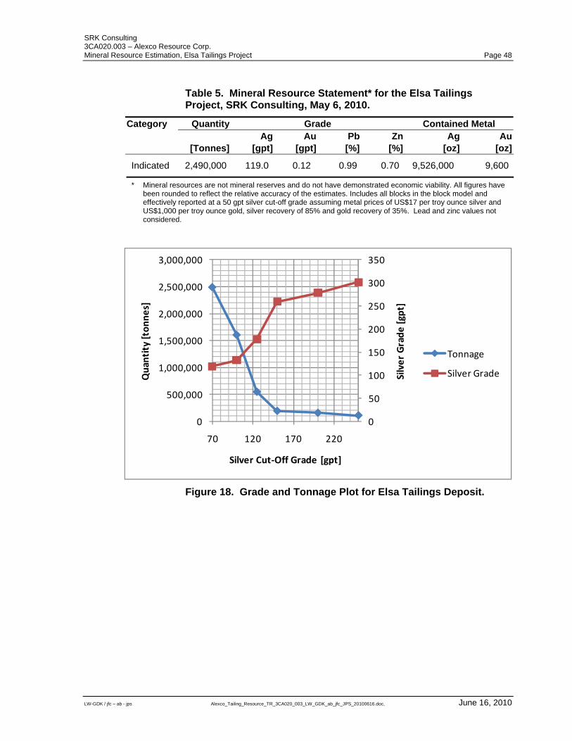
SRK Consulting 3CA020.003 – Alexco Resource Corp. Mineral Resource Estimation, Elsa Tailings Project Page 48
LW-GDK / jfc – ab - jps Alexco_Tailing_Resource_TR_3CA020_003_LW_GDK_ab_jfc_JPS_20100616.doc, June 16, 2010
Table 5. Mineral Resource Statement* for the Elsa Tailings Project, SRK Consulting, May 6, 2010.
Category Quantity Grade Contained Metal Ag Au Pb Zn Ag Au [Tonnes] [gpt] [gpt] [%] [%] [oz] [oz]
Indicated 2,490,000 119.0 0.12 0.99 0.70 9,526,000 9,600
* Mineral resources are not mineral reserves and do not have demonstrated economic viability. All figures have been rounded to reflect the relative accuracy of the estimates. Includes all blocks in the block model and effectively reported at a 50 gpt silver cut-off grade assuming metal prices of US$17 per troy ounce silver and US$1,000 per troy ounce gold, silver recovery of 85% and gold recovery of 35%. Lead and zinc values not considered.
0
50
100
150
200
250
300
350
0
500,000
1,000,000
1,500,000
2,000,000
2,500,000
3,000,000
70 120 170 220
Silver Grade [gpt]
Quantity [tonnes]
Silver Cut‐Off Grade [gpt]
Tonnage
Silver Grade
Figure 18. Grade and Tonnage Plot for Elsa Tailings Deposit.
SRK Consulting 3CA020.003 – Alexco Resource Corp. Mineral Resource Estimation, Elsa Tailings Project Page 49
LW-GDK / jfc – ab - jps Alexco_Tailing_Resource_TR_3CA020_003_LW_GDK_ab_jfc_JPS_20100616.doc, June 16, 2010
17 Other Relevant Data SRK is not aware of any other relevant data.
SRK Consulting 3CA020.003 – Alexco Resource Corp. Mineral Resource Estimation, Elsa Tailings Project Page 50
LW-GDK / jfc – ab - jps Alexco_Tailing_Resource_TR_3CA020_003_LW_GDK_ab_jfc_JPS_20100616.doc, June 16, 2010
18 Interpretation and Conclusions Exploration work by Alexco is professionally managed and procedures used conform to industry best practice. During the SRK review, challenges in sampling unconsolidated material were recognized particularly with respect to the measurement of dry specific gravity values. However, it is SRK’s opinion that these challenges do not materially impact on the quality of the resource estimates reported herein. SRK is of the opinion that the exploration data are sufficiently reliable to interpret with confidence the estimated boundaries of the block model and support evaluation and classification of mineral resources in accordance with generally accepted CIM “Estimation of Mineral Resource and Mineral Reserve Best Practices” and CIM “Definition Standards for Mineral Resources and Mineral Reserves” guidelines. Six non-contiguous and in some cases overlapping domains were generated by SRK to separate high grade zones for silver, lead and gold. An additional domain was generated for a physically distinct tailings area that is separate from the main tailings. Metal grades were estimated separately for each domain using ordinary kriging. Capping was not applied to metal assays or composites. Dry specific gravity composites were capped, using a lowest and highest capping value. After validation and classification, SRK used silver and gold grades to determine “reasonable prospects for economic extraction.” The basis of this determination were metal grades, heap leach recoveries and estimated mining and processing costs from comparable projects. The mineral resource statement prepared by SRK is reported at a silver cut-off grade of 50 gpt which is based on the likely extraction scenario. All material in the resource estimate is above this grade. Alexco has identified other areas adjacent to unestimated or currently modelled areas as outlined in Figure 19.
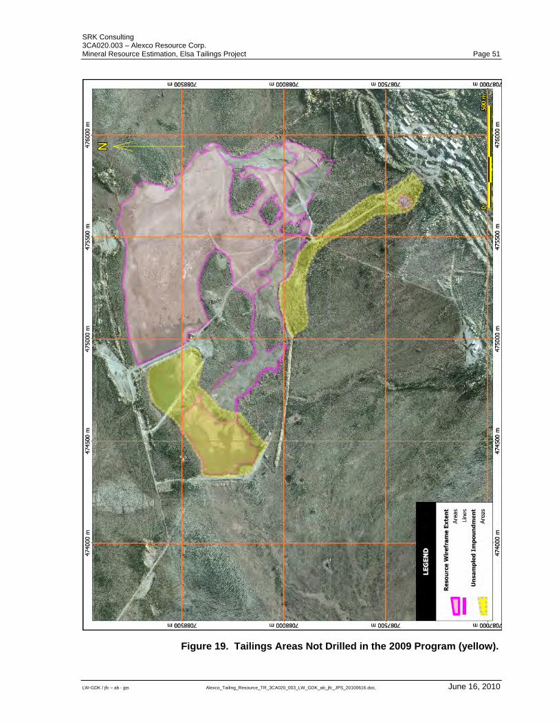
SRK Consulting 3CA020.003 – Alexco Resource Corp. Mineral Resource Estimation, Elsa Tailings Project Page 51
LW-GDK / jfc – ab - jps Alexco_Tailing_Resource_TR_3CA020_003_LW_GDK_ab_jfc_JPS_20100616.doc, June 16, 2010
Figure 19. Tailings Areas Not Drilled in the 2009 Program (yellow).
SRK Consulting 3CA020.003 – Alexco Resource Corp. Mineral Resource Estimation, Elsa Tailings Project Page 52
LW-GDK / jfc – ab - jps Alexco_Tailing_Resource_TR_3CA020_003_LW_GDK_ab_jfc_JPS_20100616.doc, June 16, 2010
19 Recommendations It is SRK’s opinion that resources for the Elsa Tailings Project have been defined to sufficient accuracy to support the preparation of a Preliminary Economic Assessment (“PEA”). Alexco has embarked on extensive metallurgical test work to document the metallurgical properties of the tailings material and evaluate appropriate processing options. This aspect is critical for the PEA study. In addition, untested areas containing additional tailings are known to occur peripherally to the current resource area. These zones offer potential to increase the current resource and are recommended for exploration sampling. Estimated costs for the recommended programs are summarized in Table 6.
Table 6. Estimated Costs of Recommended Programs.
Program Cost [CD$] Preliminary Economic Assessment $200,000 Drilling Program $50,000 Total $250,000
SRK Consulting 3CA020.003 – Alexco Resource Corp. Mineral Resource Estimation, Elsa Tailings Project Page 53
LW-GDK / jfc – ab - jps Alexco_Tailing_Resource_TR_3CA020_003_LW_GDK_ab_jfc_JPS_20100616.doc, June 16, 2010
20 References Cathro, R.J. (2006) The History and Geology of the Keno Hill Silver Camp, Yukon Territory, Geoscience Canada, v. 33, No. 3, 103 – 134 Dixon, Chris (2009) Bulk Density Test Results, Tailings Pond Elsa, Yukon, Letter dated September 21, 2009, EBA file #W14101178.006.
Dusel-Bacon, C., Lanphere, M.A., Sharp, W.D., Layer, P.W., and Hansen, V.L. (2002) Mesozoic thermal history and timing of structural events for the Yukon–Tanana Upland, east-central Alaska: 40Ar/39Ar data from metamorphic and plutonic rocks, Can. J. Earth Sci. 39: 1013–1051 Elsa Tailings Reprocessing Assessment, 2008 Closure Studies Elsa Reclamation Development Co., Ltd., June, 2009 MacGregor, Dylan (2009) 2007/2008 Geochemical Studies, Keno Hill Silver District, YT, SRK Consulting (Canada) Project no. ICE012.001.
SRK Consulting 3CA020.003 – Alexco Resource Corp. Mineral Resource Estimation, Elsa Tailings Project Page 54
LW-GDK / jfc – ab - jps Alexco_Tailing_Resource_TR_3CA020_003_LW_GDK_ab_jfc_JPS_20100616.doc, June 16, 2010
APPENDIX A Bias charts and time series for control samples
2009 drilling program
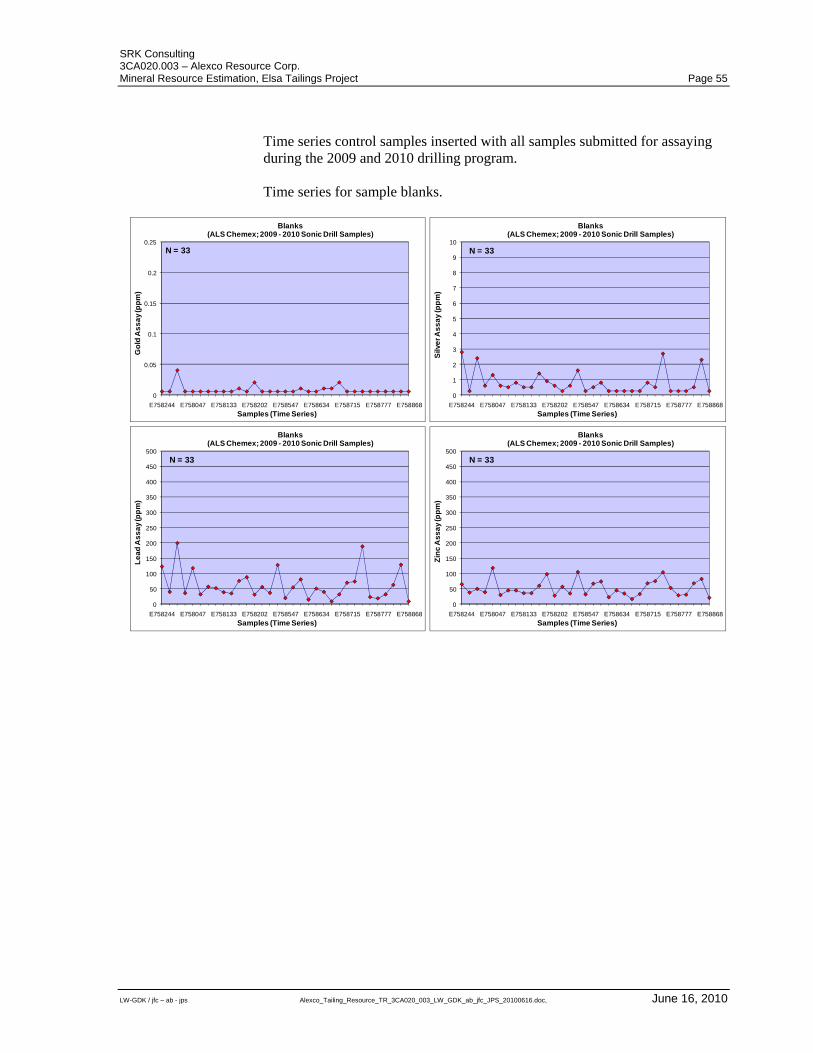
SRK Consulting 3CA020.003 – Alexco Resource Corp. Mineral Resource Estimation, Elsa Tailings Project Page 55
LW-GDK / jfc – ab - jps Alexco_Tailing_Resource_TR_3CA020_003_LW_GDK_ab_jfc_JPS_20100616.doc, June 16, 2010
Time series control samples inserted with all samples submitted for assaying during the 2009 and 2010 drilling program. Time series for sample blanks.
0
0.05
0.1
0.15
0.2
0.25
E758244 E758047 E758133 E758202 E758547 E758634 E758715 E758777 E758868
Go
ld A
ss
ay
(pp
m)
Samples (Time Series)
Blanks(ALS Chemex; 2009 - 2010 Sonic Drill Samples)
N = 33
0
1
2
3
4
5
6
7
8
9
10
E758244 E758047 E758133 E758202 E758547 E758634 E758715 E758777 E758868
Silv
er A
ss
ay
(pp
m)
Samples (Time Series)
Blanks(ALS Chemex; 2009 - 2010 Sonic Drill Samples)
N = 33
0
50
100
150
200
250
300
350
400
450
500
E758244 E758047 E758133 E758202 E758547 E758634 E758715 E758777 E758868
Le
ad
As
sa
y (p
pm
)
Samples (Time Series)
Blanks(ALS Chemex; 2009 - 2010 Sonic Drill Samples)
N = 33
0
50
100
150
200
250
300
350
400
450
500
E758244 E758047 E758133 E758202 E758547 E758634 E758715 E758777 E758868
Zin
c A
ss
ay
(pp
m)
Samples (Time Series)
Blanks(ALS Chemex; 2009 - 2010 Sonic Drill Samples)
N = 33
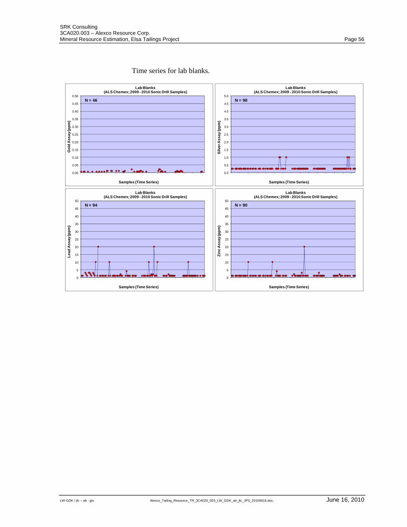
SRK Consulting 3CA020.003 – Alexco Resource Corp. Mineral Resource Estimation, Elsa Tailings Project Page 56
LW-GDK / jfc – ab - jps Alexco_Tailing_Resource_TR_3CA020_003_LW_GDK_ab_jfc_JPS_20100616.doc, June 16, 2010
Time series for lab blanks.
0.00
0.05
0.10
0.15
0.20
0.25
0.30
0.35
0.40
0.45
0.50
Go
ld A
ss
ay
(pp
m)
Samples (Time Series)
Lab Blanks(ALS Chemex; 2009 - 2010 Sonic Drill Samples)
N = 46
0.0
0.5
1.0
1.5
2.0
2.5
3.0
3.5
4.0
4.5
5.0
Silv
er A
ss
ay
(pp
m)
Samples (Time Series)
Lab Blanks(ALS Chemex; 2009 - 2010 Sonic Drill Samples)
N = 98
0
5
10
15
20
25
30
35
40
45
50
Le
ad
As
sa
y (p
pm
)
Samples (Time Series)
Lab Blanks(ALS Chemex; 2009 - 2010 Sonic Drill Samples)
N = 94
0
5
10
15
20
25
30
35
40
45
50
Zin
c A
ss
ay
(pp
m)
Samples (Time Series)
Lab Blanks(ALS Chemex; 2009 - 2010 Sonic Drill Samples)
N = 90
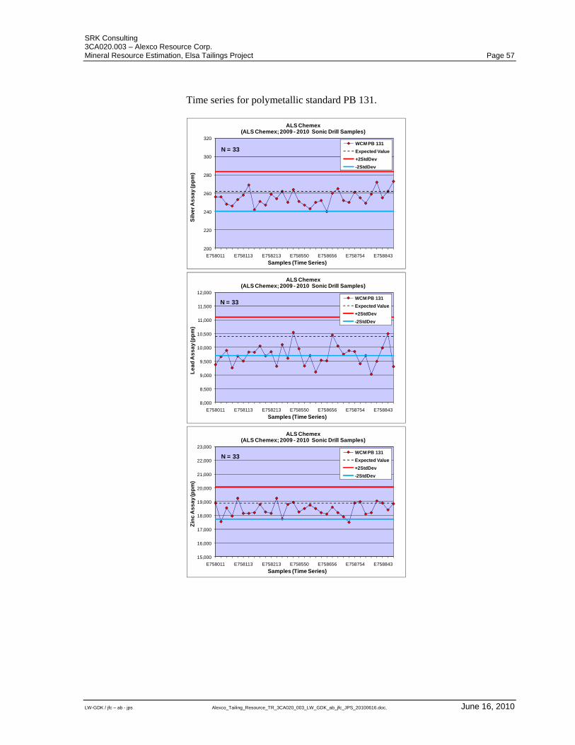
SRK Consulting 3CA020.003 – Alexco Resource Corp. Mineral Resource Estimation, Elsa Tailings Project Page 57
LW-GDK / jfc – ab - jps Alexco_Tailing_Resource_TR_3CA020_003_LW_GDK_ab_jfc_JPS_20100616.doc, June 16, 2010
Time series for polymetallic standard PB 131.
200
220
240
260
280
300
320
E758011 E758113 E758213 E758550 E758656 E758754 E758843
Silv
er A
ss
ay
(pp
m)
Samples (Time Series)
ALS Chemex(ALS Chemex; 2009 - 2010 Sonic Drill Samples)
WCM PB 131
Expected Value
+2StdDev
-2StdDev
N = 33
8,000
8,500
9,000
9,500
10,000
10,500
11,000
11,500
12,000
E758011 E758113 E758213 E758550 E758656 E758754 E758843
Le
ad
As
sa
y (p
pm
)
Samples (Time Series)
ALS Chemex(ALS Chemex; 2009 - 2010 Sonic Drill Samples)
WCM PB 131
Expected Value
+2StdDev
-2StdDev
N = 33
15,000
16,000
17,000
18,000
19,000
20,000
21,000
22,000
23,000
E758011 E758113 E758213 E758550 E758656 E758754 E758843
Zin
c A
ss
ay
(pp
m)
Samples (Time Series)
ALS Chemex(ALS Chemex; 2009 - 2010 Sonic Drill Samples)
WCM PB 131
Expected Value
+2StdDev
-2StdDev
N = 33
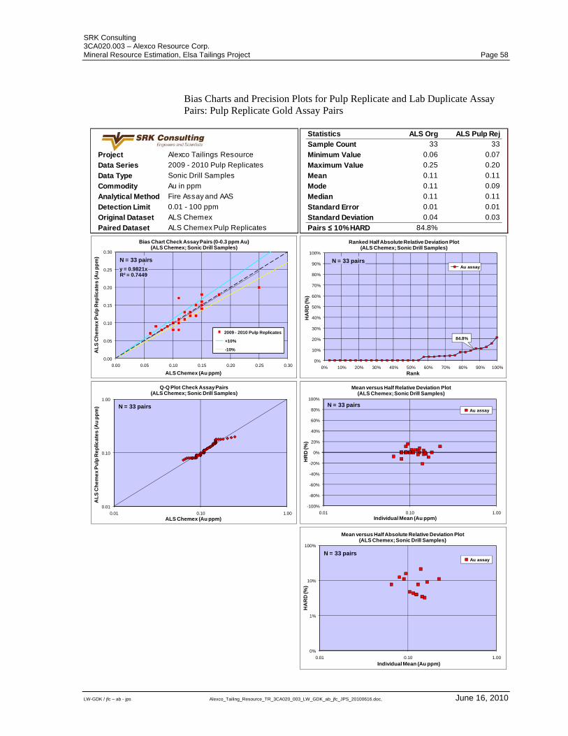
SRK Consulting 3CA020.003 – Alexco Resource Corp. Mineral Resource Estimation, Elsa Tailings Project Page 58
LW-GDK / jfc – ab - jps Alexco_Tailing_Resource_TR_3CA020_003_LW_GDK_ab_jfc_JPS_20100616.doc, June 16, 2010
Bias Charts and Precision Plots for Pulp Replicate and Lab Duplicate Assay Pairs: Pulp Replicate Gold Assay Pairs
Project Alexco Tailings Resource
Data Series 2009 - 2010 Pulp Replicates
Data Type Sonic Drill Samples
Commodity Au in ppm
Analytical Method Fire Assay and AAS
Detection Limit 0.01 - 100 ppm
Original Dataset ALS Chemex
Paired Dataset ALS Chemex Pulp Replicates
Statistics ALS Org ALS Pulp Rej
Sample Count 33 33
Minimum Value 0.06 0.07
Maximum Value 0.25 0.20
Mean 0.11 0.11
Mode 0.11 0.09
Median 0.11 0.11
Standard Error 0.01 0.01
Standard Deviation 0.04 0.03
Pairs ≤ 10% HARD 84.8%
y = 0.9821xR² = 0.7449
0.00
0.05
0.10
0.15
0.20
0.25
0.30
0.00 0.05 0.10 0.15 0.20 0.25 0.30
AL
S C
he
me
x P
ulp
Re
plic
ate
s (A
u p
pm
)
ALS Chemex (Au ppm)
Bias Chart Check Assay Pairs (0-0.3 ppm Au)(ALS Chemex; Sonic Drill Samples)
2009 - 2010 Pulp Replicates
+10%
-10%
N = 33 pairs
0%
10%
20%
30%
40%
50%
60%
70%
80%
90%
100%
0% 10% 20% 30% 40% 50% 60% 70% 80% 90% 100%
HA
RD
(%)
Rank
Ranked Half Absolute Relative Deviation Plot(ALS Chemex; Sonic Drill Samples)
Au assayN = 33 pairs
84.8%
-100%
-80%
-60%
-40%
-20%
0%
20%
40%
60%
80%
100%
0.01 0.10 1.00
HR
D (%
)
Individual Mean (Au ppm)
Mean versus Half Relative Deviation Plot(ALS Chemex; Sonic Drill Samples)
Au assayN = 33 pairs
0%
1%
10%
100%
0.01 0.10 1.00
HA
RD
(%)
Individual Mean (Au ppm)
Mean versus Half Absolute Relative Deviation Plot(ALS Chemex; Sonic Drill Samples)
Au assayN = 33 pairs
0.01
0.10
1.00
0.01 0.10 1.00
AL
S C
he
me
x P
ulp
Re
plic
ate
s (A
u p
pm
)
ALS Chemex (Au ppm)
Q-Q Plot Check Assay Pairs(ALS Chemex; Sonic Drill Samples)
N = 33 pairs
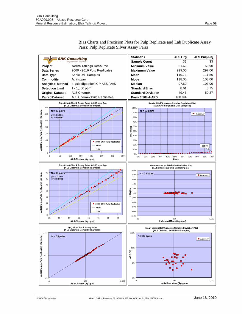
SRK Consulting 3CA020.003 – Alexco Resource Corp. Mineral Resource Estimation, Elsa Tailings Project Page 59
LW-GDK / jfc – ab - jps Alexco_Tailing_Resource_TR_3CA020_003_LW_GDK_ab_jfc_JPS_20100616.doc, June 16, 2010
Bias Charts and Precision Plots for Pulp Replicate and Lab Duplicate Assay Pairs: Pulp Replicate Silver Assay Pairs
Project Alexco Tailings Resource
Data Series 2009 - 2010 Pulp Replicates
Data Type Sonic Drill Samples
Commodity Ag in ppm
Analytical Method 4-acid digestion ICP-AES / AAS
Detection Limit 1 - 1,500 ppm
Original Dataset ALS Chemex
Paired Dataset ALS Chemex Pulp Replicates
Statistics ALS Org ALS Pulp Rej
Sample Count 33 33
Minimum Value 51.60 53.90
Maximum Value 299.00 297.00
Mean 110.73 111.86
Mode 118.00 103.00
Median 97.50 103.00
Standard Error 8.61 8.75
Standard Deviation 49.43 50.27
Pairs ≤ 10% HARD 100.0%
y = 1.0106xR² = 0.9926
0
50
100
150
200
250
300
350
0 50 100 150 200 250 300 350
AL
S C
he
me
x P
ulp
Re
plic
ate
s (A
g p
pm
)
ALS Chemex (Ag ppm)
Bias Chart Check Assay Pairs (0-350 ppm Ag)(ALS Chemex; Sonic Drill Samples)
2009 - 2010 Pulp Replicates
+10%
-10%
N = 33 pairs
0%
10%
20%
30%
40%
50%
60%
70%
80%
90%
100%
0% 10% 20% 30% 40% 50% 60% 70% 80% 90% 100%
HA
RD
(%)
Rank
Ranked Half Absolute Relative Deviation Plot(ALS Chemex; Sonic Drill Samples)
Ag assay
N = 33 pairs
100.0%
y = 1.0106xR² = 0.9926
25
35
45
55
65
75
85
95
25 35 45 55 65 75 85 95
AL
S C
he
me
x P
ulp
Re
plic
ate
s (A
g p
pm
)
ALS Chemex (Ag ppm)
Bias Chart Check Assay Pairs (0-350 ppm Ag)(ALS Chemex; Sonic Drill Samples)
2009 - 2010 Pulp Replicates
+10%
-10%
N = 33 pairs
-100%
-80%
-60%
-40%
-20%
0%
20%
40%
60%
80%
100%
10 100 1,000
HR
D (%
)
Individual Mean (Ag ppm)
Mean versus Half Relative Deviation Plot(ALS Chemex; Sonic Drill Samples)
Ag assayN = 33 pairs
10
100
1,000
10 100 1,000
AL
S C
he
me
x P
ulp
Re
plic
ate
s (A
g p
pm
)
ALS Chemex (Ag ppm)
Q-Q Plot Check Assay Pairs(ALS Chemex; Sonic Drill Samples)
N = 33 pairs
0%
1%
10%
100%
10 100 1,000
HA
RD
(%)
Individual Mean (Ag ppm)
Mean versus Half Absolute Relative Deviation Plot(ALS Chemex; Sonic Drill Samples)
Ag assay
N = 33 pairs
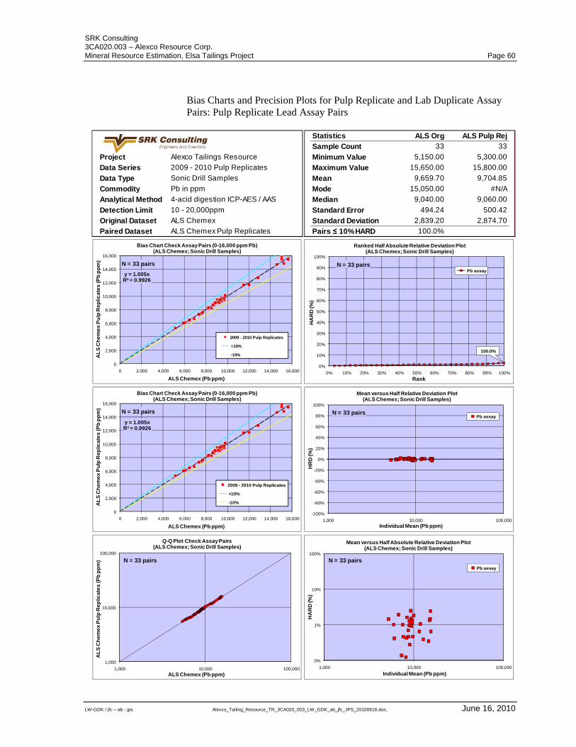
SRK Consulting 3CA020.003 – Alexco Resource Corp. Mineral Resource Estimation, Elsa Tailings Project Page 60
LW-GDK / jfc – ab - jps Alexco_Tailing_Resource_TR_3CA020_003_LW_GDK_ab_jfc_JPS_20100616.doc, June 16, 2010
Bias Charts and Precision Plots for Pulp Replicate and Lab Duplicate Assay Pairs: Pulp Replicate Lead Assay Pairs
Project Alexco Tailings Resource
Data Series 2009 - 2010 Pulp Replicates
Data Type Sonic Drill Samples
Commodity Pb in ppm
Analytical Method 4-acid digestion ICP-AES / AAS
Detection Limit 10 - 20,000ppm
Original Dataset ALS Chemex
Paired Dataset ALS Chemex Pulp Replicates
Statistics ALS Org ALS Pulp Rej
Sample Count 33 33
Minimum Value 5,150.00 5,300.00
Maximum Value 15,650.00 15,800.00
Mean 9,659.70 9,704.85
Mode 15,050.00 #N/A
Median 9,040.00 9,060.00
Standard Error 494.24 500.42
Standard Deviation 2,839.20 2,874.70
Pairs ≤ 10% HARD 100.0%
y = 1.005xR² = 0.9926
0
2,000
4,000
6,000
8,000
10,000
12,000
14,000
16,000
0 2,000 4,000 6,000 8,000 10,000 12,000 14,000 16,000
AL
S C
he
me
x P
ulp
Re
plic
ate
s (P
b p
pm
)
ALS Chemex (Pb ppm)
Bias Chart Check Assay Pairs (0-16,000 ppm Pb)(ALS Chemex; Sonic Drill Samples)
2009 - 2010 Pulp Replicates
+10%
-10%
N = 33 pairs
0%
10%
20%
30%
40%
50%
60%
70%
80%
90%
100%
0% 10% 20% 30% 40% 50% 60% 70% 80% 90% 100%
HA
RD
(%)
Rank
Ranked Half Absolute Relative Deviation Plot(ALS Chemex; Sonic Drill Samples)
Pb assayN = 33 pairs
100.0%
y = 1.005xR² = 0.9926
0
2,000
4,000
6,000
8,000
10,000
12,000
14,000
16,000
0 2,000 4,000 6,000 8,000 10,000 12,000 14,000 16,000
AL
S C
he
me
x P
ulp
Re
plic
ate
s (P
b p
pm
)
ALS Chemex (Pb ppm)
Bias Chart Check Assay Pairs (0-16,000 ppm Pb)(ALS Chemex; Sonic Drill Samples)
2009 - 2010 Pulp Replicates
+10%
-10%
N = 33 pairs
-100%
-80%
-60%
-40%
-20%
0%
20%
40%
60%
80%
100%
1,000 10,000 100,000
HR
D (%
)
Individual Mean (Pb ppm)
Mean versus Half Relative Deviation Plot(ALS Chemex; Sonic Drill Samples)
Pb assayN = 33 pairs
1,000
10,000
100,000
1,000 10,000 100,000
AL
S C
he
me
x P
ulp
Re
plic
ate
s (P
b p
pm
)
ALS Chemex (Pb ppm)
Q-Q Plot Check Assay Pairs(ALS Chemex; Sonic Drill Samples)
N = 33 pairs
0%
1%
10%
100%
1,000 10,000 100,000
HA
RD
(%)
Individual Mean (Pb ppm)
Mean versus Half Absolute Relative Deviation Plot(ALS Chemex; Sonic Drill Samples)
Pb assay
N = 33 pairs
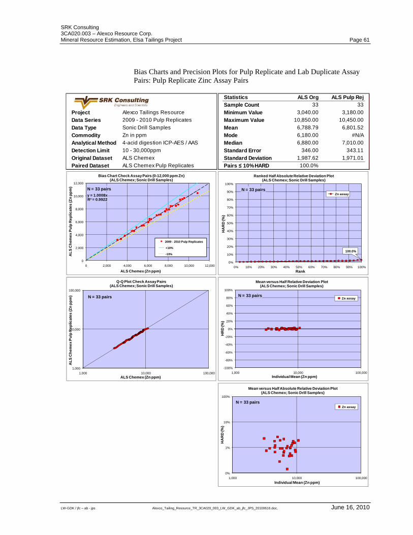
SRK Consulting 3CA020.003 – Alexco Resource Corp. Mineral Resource Estimation, Elsa Tailings Project Page 61
LW-GDK / jfc – ab - jps Alexco_Tailing_Resource_TR_3CA020_003_LW_GDK_ab_jfc_JPS_20100616.doc, June 16, 2010
Bias Charts and Precision Plots for Pulp Replicate and Lab Duplicate Assay Pairs: Pulp Replicate Zinc Assay Pairs
Project Alexco Tailings Resource
Data Series 2009 - 2010 Pulp Replicates
Data Type Sonic Drill Samples
Commodity Zn in ppm
Analytical Method 4-acid digestion ICP-AES / AAS
Detection Limit 10 - 30,000ppm
Original Dataset ALS Chemex
Paired Dataset ALS Chemex Pulp Replicates
Statistics ALS Org ALS Pulp Rej
Sample Count 33 33
Minimum Value 3,040.00 3,180.00
Maximum Value 10,850.00 10,450.00
Mean 6,788.79 6,801.52
Mode 6,180.00 #N/A
Median 6,880.00 7,010.00
Standard Error 346.00 343.11
Standard Deviation 1,987.62 1,971.01
Pairs ≤ 10% HARD 100.0%
y = 1.0008xR² = 0.9922
0
2,000
4,000
6,000
8,000
10,000
12,000
0 2,000 4,000 6,000 8,000 10,000 12,000
AL
S C
he
me
x P
ulp
Re
plic
ate
s (Z
n p
pm
)
ALS Chemex (Zn ppm)
Bias Chart Check Assay Pairs (0-12,000 ppm Zn)(ALS Chemex; Sonic Drill Samples)
2009 - 2010 Pulp Replicates
+10%
-10%
N = 33 pairs
0%
10%
20%
30%
40%
50%
60%
70%
80%
90%
100%
0% 10% 20% 30% 40% 50% 60% 70% 80% 90% 100%
HA
RD
(%)
Rank
Ranked Half Absolute Relative Deviation Plot(ALS Chemex; Sonic Drill Samples)
Zn assayN = 33 pairs
100.0%
-100%
-80%
-60%
-40%
-20%
0%
20%
40%
60%
80%
100%
1,000 10,000 100,000
HR
D (%
)
Individual Mean (Zn ppm)
Mean versus Half Relative Deviation Plot(ALS Chemex; Sonic Drill Samples)
Zn assayN = 33 pairs
1,000
10,000
100,000
1,000 10,000 100,000
AL
S C
he
me
x P
ulp
Re
plic
ate
s (Z
n p
pm
)
ALS Chemex (Zn ppm)
Q-Q Plot Check Assay Pairs(ALS Chemex; Sonic Drill Samples)
N = 33 pairs
0%
1%
10%
100%
1,000 10,000 100,000
HA
RD
(%)
Individual Mean (Zn ppm)
Mean versus Half Absolute Relative Deviation Plot(ALS Chemex; Sonic Drill Samples)
Zn assayN = 33 pairs
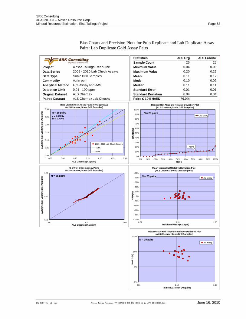
SRK Consulting 3CA020.003 – Alexco Resource Corp. Mineral Resource Estimation, Elsa Tailings Project Page 62
LW-GDK / jfc – ab - jps Alexco_Tailing_Resource_TR_3CA020_003_LW_GDK_ab_jfc_JPS_20100616.doc, June 16, 2010
Bias Charts and Precision Plots for Pulp Replicate and Lab Duplicate Assay Pairs: Lab Duplicate Gold Assay Pairs
Project Alexco Tailings Resource
Data Series 2009 - 2010 Lab Check Assays
Data Type Sonic Drill Samples
Commodity Au in ppm
Analytical Method Fire Assay and AAS
Detection Limit 0.01 - 100 ppm
Original Dataset ALS Chemex
Paired Dataset ALS Chemex Lab Checks
Statistics ALS Org ALS LabChk
Sample Count 25 25
Minimum Value 0.04 0.05
Maximum Value 0.20 0.22
Mean 0.11 0.12
Mode 0.10 0.09
Median 0.11 0.11
Standard Error 0.01 0.01
Standard Deviation 0.04 0.04
Pairs ≤ 10% HARD 76.0%
y = 1.0223xR² = 0.7366
0.00
0.05
0.10
0.15
0.20
0.25
0.30
0.00 0.05 0.10 0.15 0.20 0.25 0.30
AL
S C
he
me
x L
ab
Ch
ec
ks
(Au
pp
m)
ALS Chemex (Au ppm)
Bias Chart Check Assay Pairs (0-0.3 ppm Au)(ALS Chemex; Sonic Drill Samples)
2009 - 2010 Lab Check Assays
+10%
-10%
N = 25 pairs
0%
10%
20%
30%
40%
50%
60%
70%
80%
90%
100%
0% 10% 20% 30% 40% 50% 60% 70% 80% 90% 100%
HA
RD
(%)
Rank
Ranked Half Absolute Relative Deviation Plot(ALS Chemex; Sonic Drill Samples)
Au assayN = 25 pairs
76.0%
-100%
-80%
-60%
-40%
-20%
0%
20%
40%
60%
80%
100%
0.01 0.10 1.00
HR
D (%
)
Individual Mean (Au ppm)
Mean versus Half Relative Deviation Plot(ALS Chemex; Sonic Drill Samples)
Au assayN = 25 pairs
0.01
0.10
1.00
0.01 0.10 1.00
AL
S C
he
me
x L
ab
Ch
ec
ks
(Au
pp
m)
ALS Chemex (Au ppm)
Q-Q Plot Check Assay Pairs(ALS Chemex; Sonic Drill Samples)
N = 25 pairs
0%
1%
10%
100%
0.01 0.10 1.00
HA
RD
(%)
Individual Mean (Au ppm)
Mean versus Half Absolute Relative Deviation Plot(ALS Chemex; Sonic Drill Samples)
Au assay
N = 25 pairs
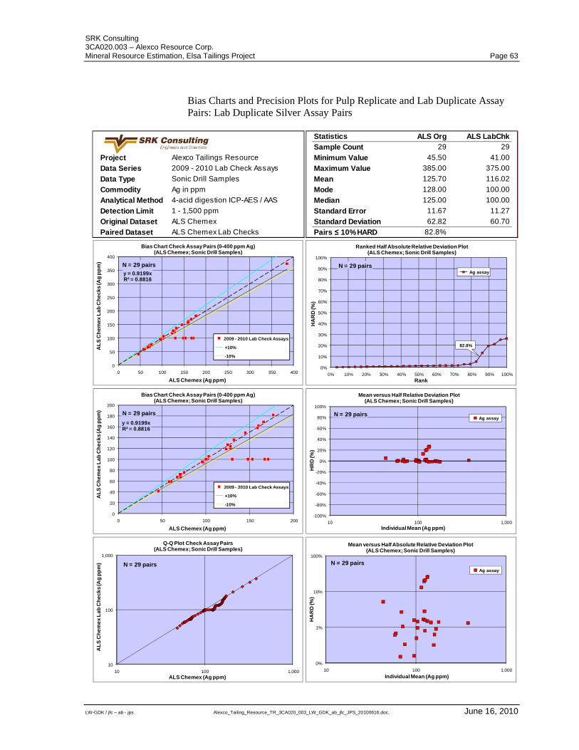
SRK Consulting 3CA020.003 – Alexco Resource Corp. Mineral Resource Estimation, Elsa Tailings Project Page 63
LW-GDK / jfc – ab - jps Alexco_Tailing_Resource_TR_3CA020_003_LW_GDK_ab_jfc_JPS_20100616.doc, June 16, 2010
Bias Charts and Precision Plots for Pulp Replicate and Lab Duplicate Assay Pairs: Lab Duplicate Silver Assay Pairs
Project Alexco Tailings Resource
Data Series 2009 - 2010 Lab Check Assays
Data Type Sonic Drill Samples
Commodity Ag in ppm
Analytical Method 4-acid digestion ICP-AES / AAS
Detection Limit 1 - 1,500 ppm
Original Dataset ALS Chemex
Paired Dataset ALS Chemex Lab Checks
Statistics ALS Org ALS LabChk
Sample Count 29 29
Minimum Value 45.50 41.00
Maximum Value 385.00 375.00
Mean 125.70 116.02
Mode 128.00 100.00
Median 125.00 100.00
Standard Error 11.67 11.27
Standard Deviation 62.82 60.70
Pairs ≤ 10% HARD 82.8%
y = 0.9199xR² = 0.8816
0
50
100
150
200
250
300
350
400
0 50 100 150 200 250 300 350 400
AL
S C
he
me
x L
ab
Ch
ec
ks
(Ag
pp
m)
ALS Chemex (Ag ppm)
Bias Chart Check Assay Pairs (0-400 ppm Ag)(ALS Chemex; Sonic Drill Samples)
2009 - 2010 Lab Check Assays
+10%
-10%
N = 29 pairs
0%
10%
20%
30%
40%
50%
60%
70%
80%
90%
100%
0% 10% 20% 30% 40% 50% 60% 70% 80% 90% 100%
HA
RD
(%)
Rank
Ranked Half Absolute Relative Deviation Plot(ALS Chemex; Sonic Drill Samples)
Ag assayN = 29 pairs
82.8%
y = 0.9199xR² = 0.8816
0
20
40
60
80
100
120
140
160
180
200
0 50 100 150 200
AL
S C
he
me
x L
ab
Ch
ec
ks
(Ag
pp
m)
ALS Chemex (Ag ppm)
Bias Chart Check Assay Pairs (0-400 ppm Ag)(ALS Chemex; Sonic Drill Samples)
2009 - 2010 Lab Check Assays
+10%
-10%
N = 29 pairs
-100%
-80%
-60%
-40%
-20%
0%
20%
40%
60%
80%
100%
10 100 1,000
HR
D (%
)
Individual Mean (Ag ppm)
Mean versus Half Relative Deviation Plot(ALS Chemex; Sonic Drill Samples)
Ag assayN = 29 pairs
10
100
1,000
10 100 1,000
AL
S C
he
me
x L
ab
Ch
ec
ks
(Ag
pp
m)
ALS Chemex (Ag ppm)
Q-Q Plot Check Assay Pairs(ALS Chemex; Sonic Drill Samples)
N = 29 pairs
0%
1%
10%
100%
10 100 1,000
HA
RD
(%)
Individual Mean (Ag ppm)
Mean versus Half Absolute Relative Deviation Plot(ALS Chemex; Sonic Drill Samples)
Ag assay
N = 29 pairs
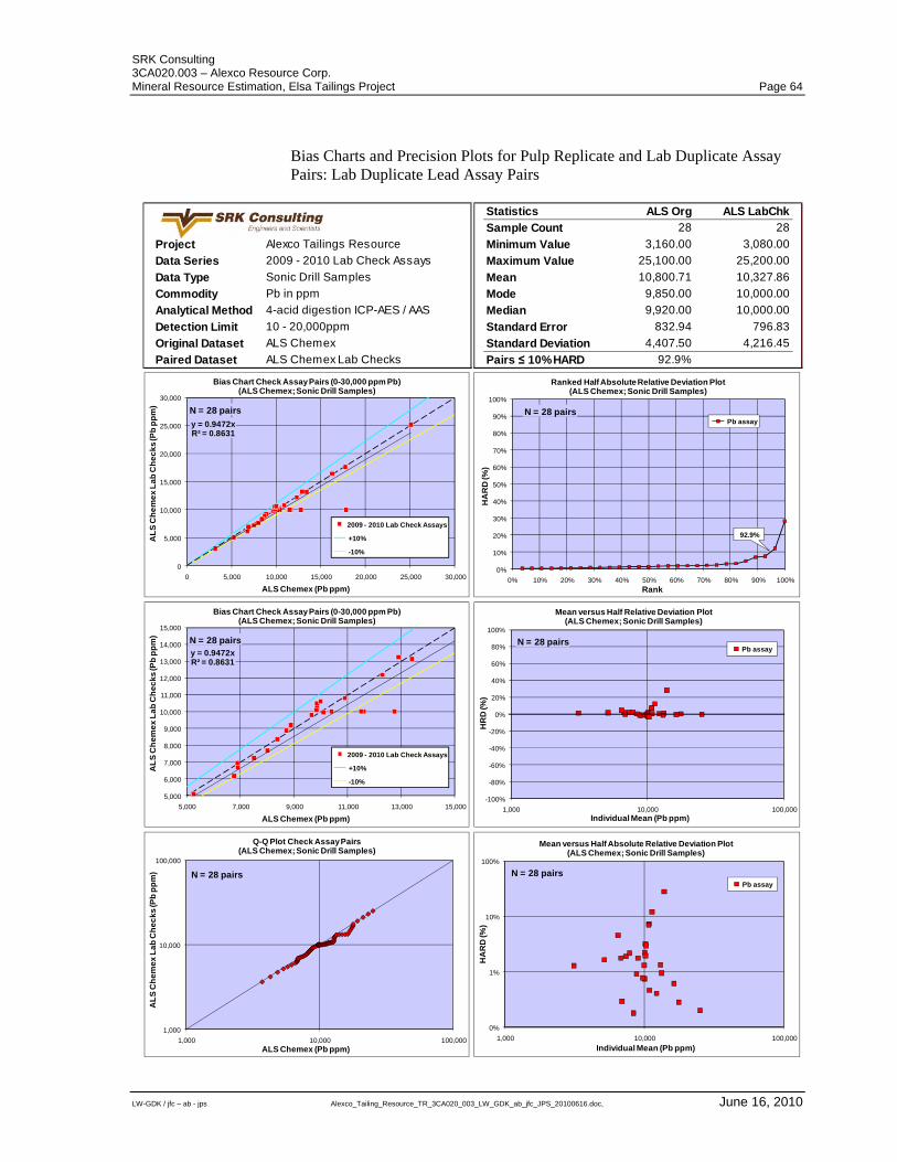
SRK Consulting 3CA020.003 – Alexco Resource Corp. Mineral Resource Estimation, Elsa Tailings Project Page 64
LW-GDK / jfc – ab - jps Alexco_Tailing_Resource_TR_3CA020_003_LW_GDK_ab_jfc_JPS_20100616.doc, June 16, 2010
Bias Charts and Precision Plots for Pulp Replicate and Lab Duplicate Assay Pairs: Lab Duplicate Lead Assay Pairs
Project Alexco Tailings Resource
Data Series 2009 - 2010 Lab Check Assays
Data Type Sonic Drill Samples
Commodity Pb in ppm
Analytical Method 4-acid digestion ICP-AES / AAS
Detection Limit 10 - 20,000ppm
Original Dataset ALS Chemex
Paired Dataset ALS Chemex Lab Checks
Statistics ALS Org ALS LabChk
Sample Count 28 28
Minimum Value 3,160.00 3,080.00
Maximum Value 25,100.00 25,200.00
Mean 10,800.71 10,327.86
Mode 9,850.00 10,000.00
Median 9,920.00 10,000.00
Standard Error 832.94 796.83
Standard Deviation 4,407.50 4,216.45
Pairs ≤ 10% HARD 92.9%
y = 0.9472xR² = 0.8631
0
5,000
10,000
15,000
20,000
25,000
30,000
0 5,000 10,000 15,000 20,000 25,000 30,000
AL
S C
he
me
x L
ab
Ch
ec
ks
(Pb
pp
m)
ALS Chemex (Pb ppm)
Bias Chart Check Assay Pairs (0-30,000 ppm Pb)(ALS Chemex; Sonic Drill Samples)
2009 - 2010 Lab Check Assays
+10%
-10%
N = 28 pairs
0%
10%
20%
30%
40%
50%
60%
70%
80%
90%
100%
0% 10% 20% 30% 40% 50% 60% 70% 80% 90% 100%
HA
RD
(%)
Rank
Ranked Half Absolute Relative Deviation Plot(ALS Chemex; Sonic Drill Samples)
Pb assayN = 28 pairs
92.9%
y = 0.9472xR² = 0.8631
5,000
6,000
7,000
8,000
9,000
10,000
11,000
12,000
13,000
14,000
15,000
5,000 7,000 9,000 11,000 13,000 15,000
AL
S C
he
me
x L
ab
Ch
ec
ks
(Pb
pp
m)
ALS Chemex (Pb ppm)
Bias Chart Check Assay Pairs (0-30,000 ppm Pb)(ALS Chemex; Sonic Drill Samples)
2009 - 2010 Lab Check Assays
+10%
-10%
N = 28 pairs
-100%
-80%
-60%
-40%
-20%
0%
20%
40%
60%
80%
100%
1,000 10,000 100,000
HR
D (%
)
Individual Mean (Pb ppm)
Mean versus Half Relative Deviation Plot(ALS Chemex; Sonic Drill Samples)
Pb assayN = 28 pairs
1,000
10,000
100,000
1,000 10,000 100,000
AL
S C
he
me
x L
ab
Ch
ec
ks
(Pb
pp
m)
ALS Chemex (Pb ppm)
Q-Q Plot Check Assay Pairs(ALS Chemex; Sonic Drill Samples)
N = 28 pairs
0%
1%
10%
100%
1,000 10,000 100,000
HA
RD
(%)
Individual Mean (Pb ppm)
Mean versus Half Absolute Relative Deviation Plot(ALS Chemex; Sonic Drill Samples)
Pb assay
N = 28 pairs
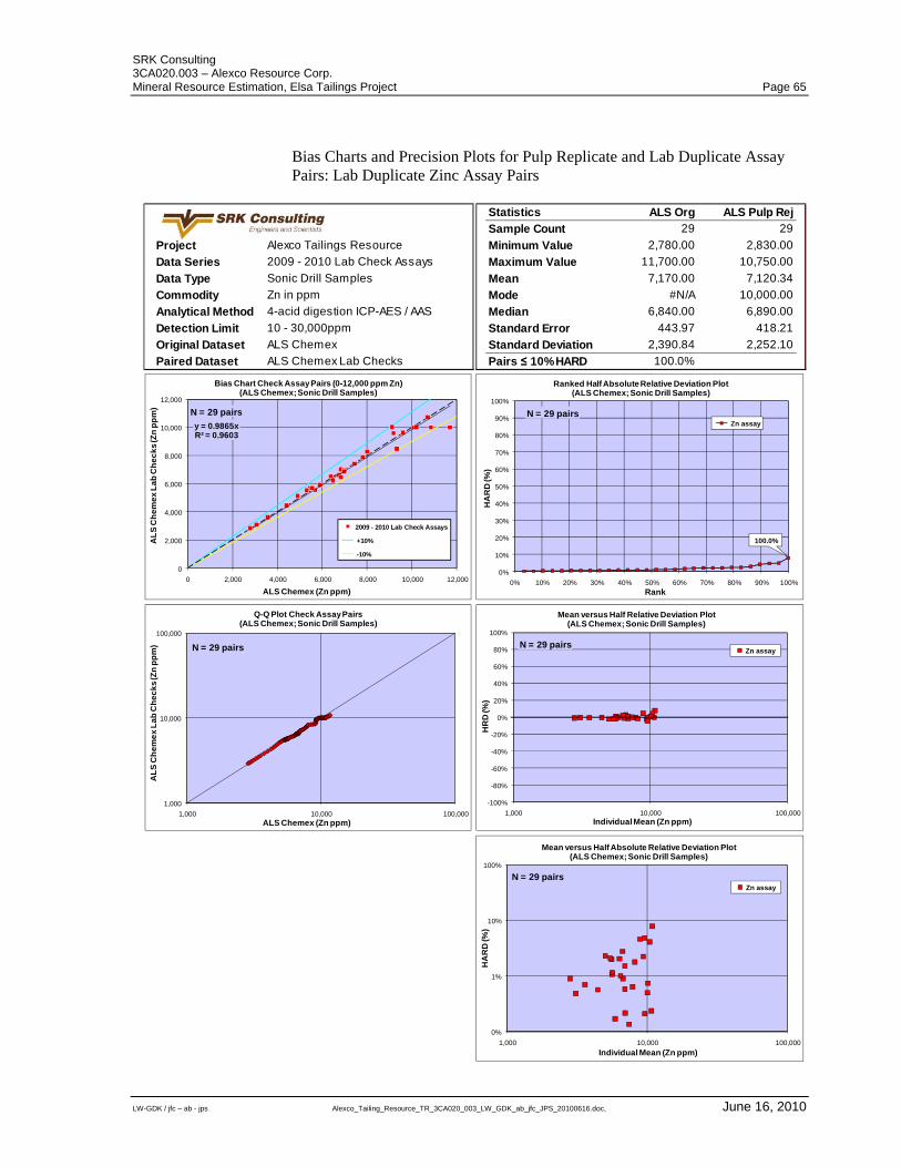
SRK Consulting 3CA020.003 – Alexco Resource Corp. Mineral Resource Estimation, Elsa Tailings Project Page 65
LW-GDK / jfc – ab - jps Alexco_Tailing_Resource_TR_3CA020_003_LW_GDK_ab_jfc_JPS_20100616.doc, June 16, 2010
Bias Charts and Precision Plots for Pulp Replicate and Lab Duplicate Assay Pairs: Lab Duplicate Zinc Assay Pairs
Project Alexco Tailings Resource
Data Series 2009 - 2010 Lab Check Assays
Data Type Sonic Drill Samples
Commodity Zn in ppm
Analytical Method 4-acid digestion ICP-AES / AAS
Detection Limit 10 - 30,000ppm
Original Dataset ALS Chemex
Paired Dataset ALS Chemex Lab Checks
Statistics ALS Org ALS Pulp Rej
Sample Count 29 29
Minimum Value 2,780.00 2,830.00
Maximum Value 11,700.00 10,750.00
Mean 7,170.00 7,120.34
Mode #N/A 10,000.00
Median 6,840.00 6,890.00
Standard Error 443.97 418.21
Standard Deviation 2,390.84 2,252.10
Pairs ≤ 10% HARD 100.0%
y = 0.9865xR² = 0.9603
0
2,000
4,000
6,000
8,000
10,000
12,000
0 2,000 4,000 6,000 8,000 10,000 12,000
AL
S C
he
me
x L
ab
Ch
ec
ks
(Zn
pp
m)
ALS Chemex (Zn ppm)
Bias Chart Check Assay Pairs (0-12,000 ppm Zn)(ALS Chemex; Sonic Drill Samples)
2009 - 2010 Lab Check Assays
+10%
-10%
N = 29 pairs
0%
10%
20%
30%
40%
50%
60%
70%
80%
90%
100%
0% 10% 20% 30% 40% 50% 60% 70% 80% 90% 100%
HA
RD
(%)
Rank
Ranked Half Absolute Relative Deviation Plot(ALS Chemex; Sonic Drill Samples)
Zn assayN = 29 pairs
100.0%
-100%
-80%
-60%
-40%
-20%
0%
20%
40%
60%
80%
100%
1,000 10,000 100,000
HR
D (%
)
Individual Mean (Zn ppm)
Mean versus Half Relative Deviation Plot(ALS Chemex; Sonic Drill Samples)
Zn assayN = 29 pairs
1,000
10,000
100,000
1,000 10,000 100,000
AL
S C
he
me
x L
ab
Ch
ec
ks
(Zn
pp
m)
ALS Chemex (Zn ppm)
Q-Q Plot Check Assay Pairs(ALS Chemex; Sonic Drill Samples)
N = 29 pairs
0%
1%
10%
100%
1,000 10,000 100,000
HA
RD
(%)
Individual Mean (Zn ppm)
Mean versus Half Absolute Relative Deviation Plot(ALS Chemex; Sonic Drill Samples)
Zn assay
N = 29 pairs
SRK Consulting 3CA020.003 – Alexco Resource Corp. Mineral Resource Estimation, Elsa Tailings Project Page 66
LW-GDK / jfc – ab - jps Alexco_Tailing_Resource_TR_3CA020_003_LW_GDK_ab_jfc_JPS_20100616.doc, June 16, 2010
APPENDIX B
Summary Logs of Tailings Trenches
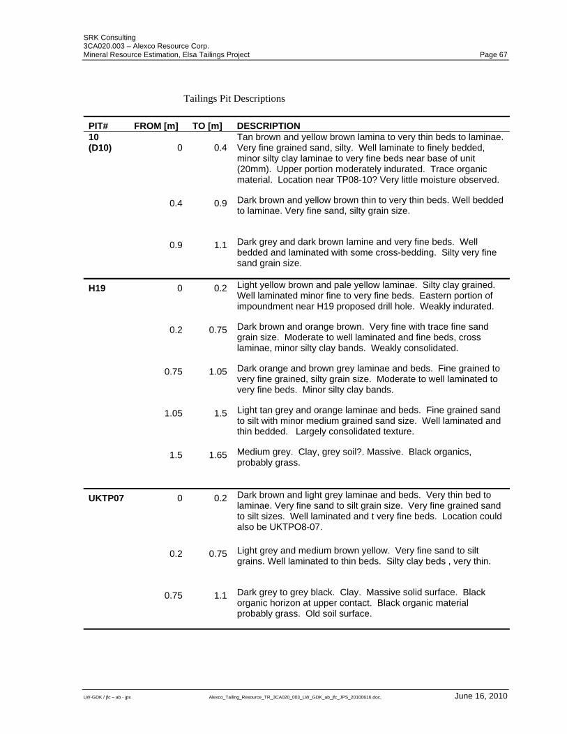
SRK Consulting 3CA020.003 – Alexco Resource Corp. Mineral Resource Estimation, Elsa Tailings Project Page 67
LW-GDK / jfc – ab - jps Alexco_Tailing_Resource_TR_3CA020_003_LW_GDK_ab_jfc_JPS_20100616.doc, June 16, 2010
Tailings Pit Descriptions
PIT# FROM [m] TO [m] DESCRIPTION 10 (D10) 0 0.4
Tan brown and yellow brown lamina to very thin beds to laminae. Very fine grained sand, silty. Well laminate to finely bedded, minor silty clay laminae to very fine beds near base of unit (20mm). Upper portion moderately indurated. Trace organic material. Location near TP08-10? Very little moisture observed.
0.4 0.9 Dark brown and yellow brown thin to very thin beds. Well bedded to laminae. Very fine sand, silty grain size.
0.9 1.1 Dark grey and dark brown lamine and very fine beds. Well bedded and laminated with some cross-bedding. Silty very fine sand grain size.
H19 0 0.2 Light yellow brown and pale yellow laminae. Silty clay grained. Well laminated minor fine to very fine beds. Eastern portion of impoundment near H19 proposed drill hole. Weakly indurated.
0.2 0.75 Dark brown and orange brown. Very fine with trace fine sand grain size. Moderate to well laminated and fine beds, cross laminae, minor silty clay bands. Weakly consolidated.
0.75 1.05 Dark orange and brown grey laminae and beds. Fine grained to very fine grained, silty grain size. Moderate to well laminated to very fine beds. Minor silty clay bands.
1.05 1.5 Light tan grey and orange laminae and beds. Fine grained sand to silt with minor medium grained sand size. Well laminated and thin bedded. Largely consolidated texture.
1.5 1.65 Medium grey. Clay, grey soil?. Massive. Black organics, probably grass.
UKTP07 0 0.2 Dark brown and light grey laminae and beds. Very thin bed to laminae. Very fine sand to silt grain size. Very fine grained sand to silt sizes. Well laminated and t very fine beds. Location could also be UKTPO8-07.
0.2 0.75 Light grey and medium brown yellow. Very fine sand to silt grains. Well laminated to thin beds. Silty clay beds , very thin.
0.75 1.1 Dark grey to grey black. Clay. Massive solid surface. Black organic horizon at upper contact. Black organic material probably grass. Old soil surface.
SRK Consulting 3CA020.003 – Alexco Resource Corp. Mineral Resource Estimation, Elsa Tailings Project Page 68
LW-GDK / jfc – ab - jps Alexco_Tailing_Resource_TR_3CA020_003_LW_GDK_ab_jfc_JPS_20100616.doc, June 16, 2010
APPENDIX C
Summary Statistics and Cumulative Frequency Plots
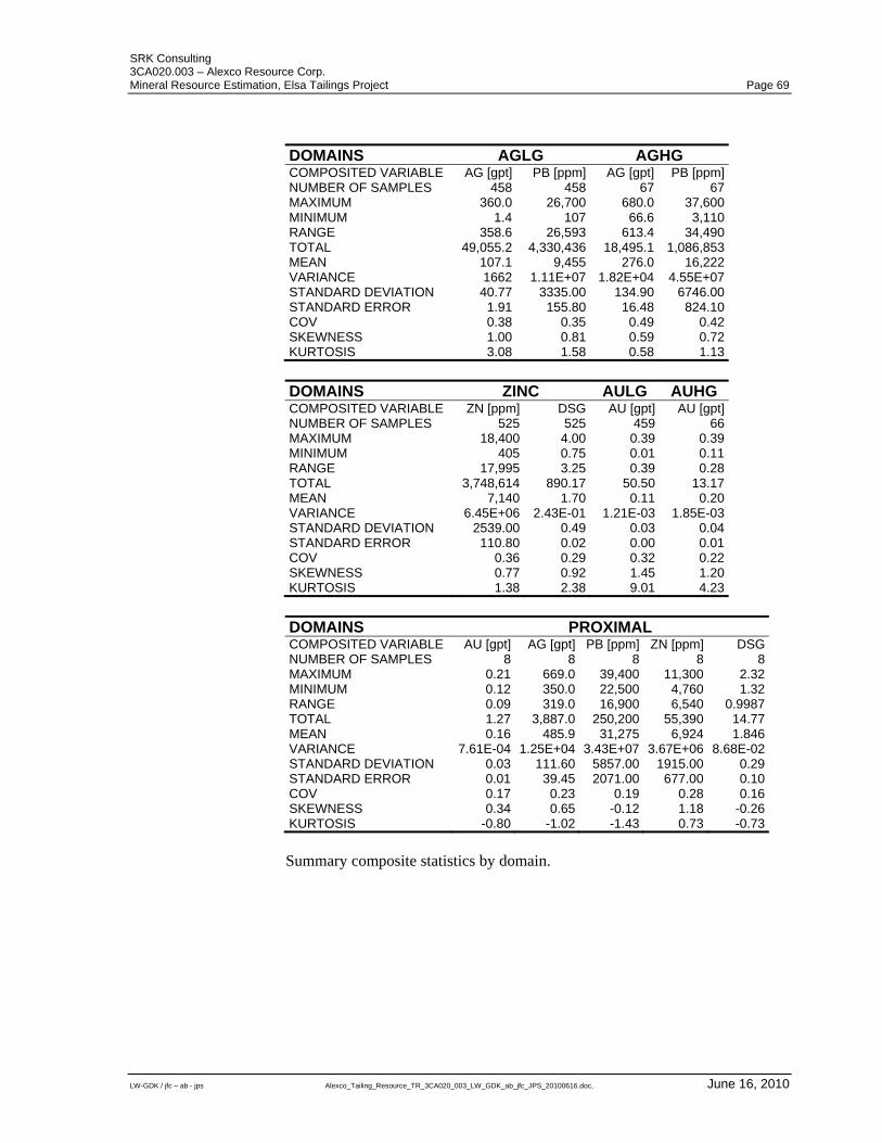
SRK Consulting 3CA020.003 – Alexco Resource Corp. Mineral Resource Estimation, Elsa Tailings Project Page 69
LW-GDK / jfc – ab - jps Alexco_Tailing_Resource_TR_3CA020_003_LW_GDK_ab_jfc_JPS_20100616.doc, June 16, 2010
DOMAINS AGLG AGHG COMPOSITED VARIABLE AG [gpt] PB [ppm] AG [gpt] PB [ppm]NUMBER OF SAMPLES 458 458 67 67MAXIMUM 360.0 26,700 680.0 37,600MINIMUM 1.4 107 66.6 3,110RANGE 358.6 26,593 613.4 34,490TOTAL 49,055.2 4,330,436 18,495.1 1,086,853MEAN 107.1 9,455 276.0 16,222VARIANCE 1662 1.11E+07 1.82E+04 4.55E+07STANDARD DEVIATION 40.77 3335.00 134.90 6746.00STANDARD ERROR 1.91 155.80 16.48 824.10COV 0.38 0.35 0.49 0.42SKEWNESS 1.00 0.81 0.59 0.72KURTOSIS 3.08 1.58 0.58 1.13
DOMAINS ZINC AULG AUHG COMPOSITED VARIABLE ZN [ppm] DSG AU [gpt] AU [gpt]NUMBER OF SAMPLES 525 525 459 66MAXIMUM 18,400 4.00 0.39 0.39MINIMUM 405 0.75 0.01 0.11RANGE 17,995 3.25 0.39 0.28TOTAL 3,748,614 890.17 50.50 13.17MEAN 7,140 1.70 0.11 0.20VARIANCE 6.45E+06 2.43E-01 1.21E-03 1.85E-03STANDARD DEVIATION 2539.00 0.49 0.03 0.04STANDARD ERROR 110.80 0.02 0.00 0.01COV 0.36 0.29 0.32 0.22SKEWNESS 0.77 0.92 1.45 1.20KURTOSIS 1.38 2.38 9.01 4.23
DOMAINS PROXIMAL COMPOSITED VARIABLE AU [gpt] AG [gpt] PB [ppm] ZN [ppm] DSGNUMBER OF SAMPLES 8 8 8 8 8MAXIMUM 0.21 669.0 39,400 11,300 2.32MINIMUM 0.12 350.0 22,500 4,760 1.32RANGE 0.09 319.0 16,900 6,540 0.9987TOTAL 1.27 3,887.0 250,200 55,390 14.77MEAN 0.16 485.9 31,275 6,924 1.846VARIANCE 7.61E-04 1.25E+04 3.43E+07 3.67E+06 8.68E-02STANDARD DEVIATION 0.03 111.60 5857.00 1915.00 0.29STANDARD ERROR 0.01 39.45 2071.00 677.00 0.10COV 0.17 0.23 0.19 0.28 0.16SKEWNESS 0.34 0.65 -0.12 1.18 -0.26KURTOSIS -0.80 -1.02 -1.43 0.73 -0.73
Summary composite statistics by domain.
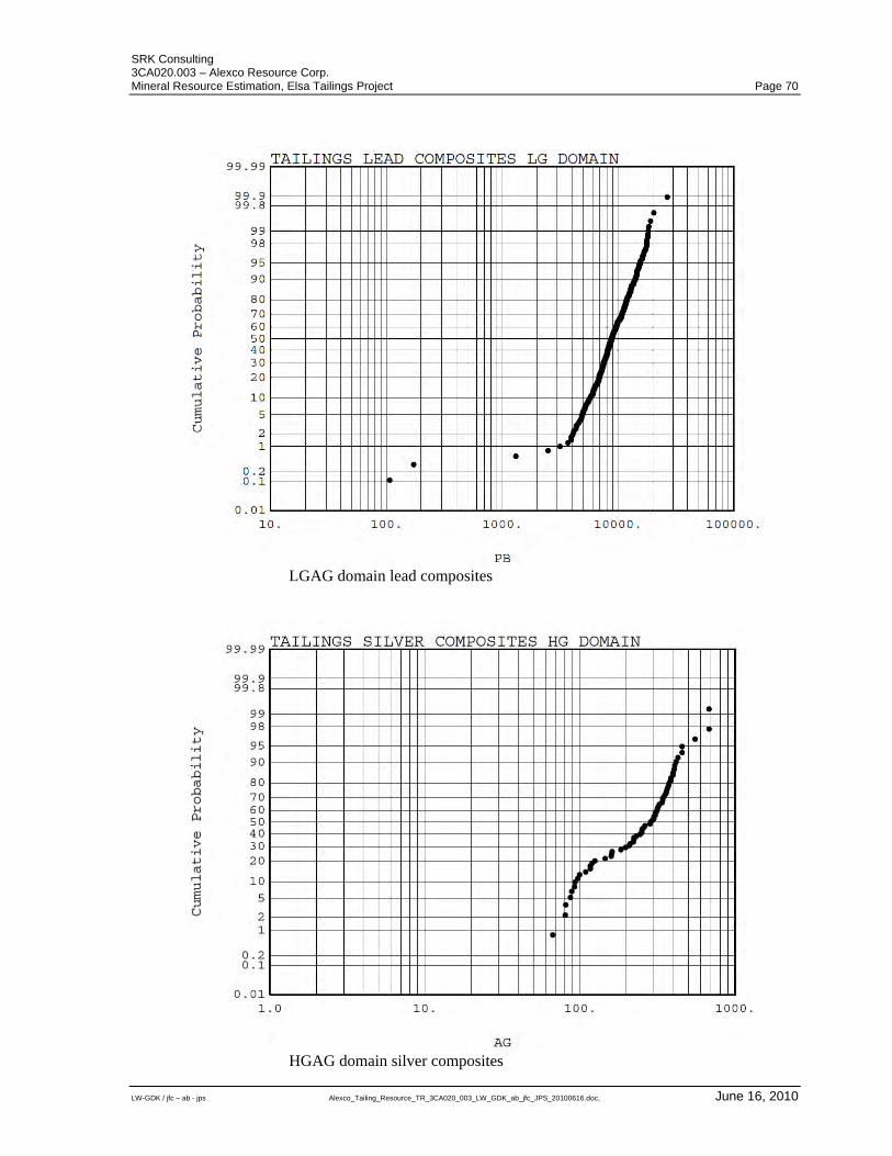
SRK Consulting 3CA020.003 – Alexco Resource Corp. Mineral Resource Estimation, Elsa Tailings Project Page 70
LW-GDK / jfc – ab - jps Alexco_Tailing_Resource_TR_3CA020_003_LW_GDK_ab_jfc_JPS_20100616.doc, June 16, 2010
LGAG domain lead composites
HGAG domain silver composites
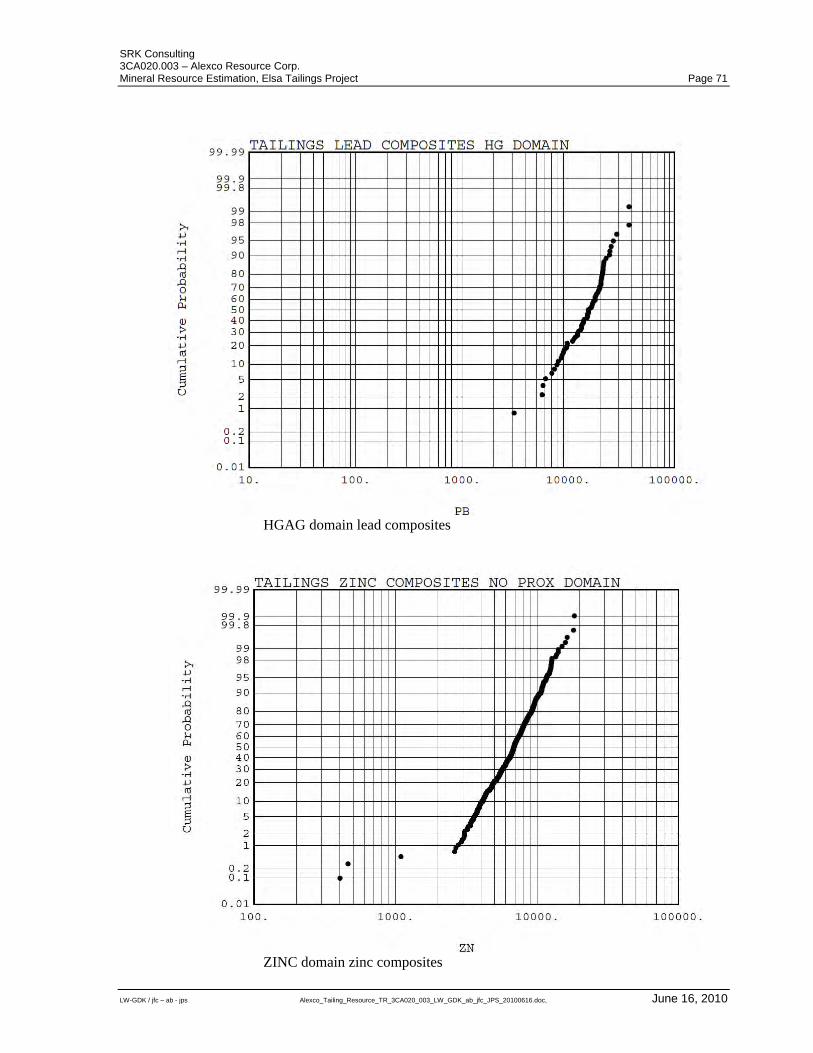
SRK Consulting 3CA020.003 – Alexco Resource Corp. Mineral Resource Estimation, Elsa Tailings Project Page 71
LW-GDK / jfc – ab - jps Alexco_Tailing_Resource_TR_3CA020_003_LW_GDK_ab_jfc_JPS_20100616.doc, June 16, 2010
HGAG domain lead composites
ZINC domain zinc composites
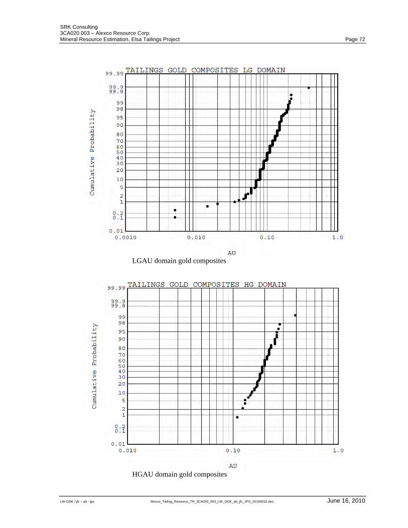
SRK Consulting 3CA020.003 – Alexco Resource Corp. Mineral Resource Estimation, Elsa Tailings Project Page 72
LW-GDK / jfc – ab - jps Alexco_Tailing_Resource_TR_3CA020_003_LW_GDK_ab_jfc_JPS_20100616.doc, June 16, 2010
LGAU domain gold composites
HGAU domain gold composites

SRK Consulting 3CA020.003 – Alexco Resource Corp. Mineral Resource Estimation, Elsa Tailings Project Page 73
LW-GDK / jfc – ab - jps Alexco_Tailing_Resource_TR_3CA020_003_LW_GDK_ab_jfc_JPS_20100616.doc, June 16, 2010
APPENDIX D
Variograms and Summary of Variogram Parameters
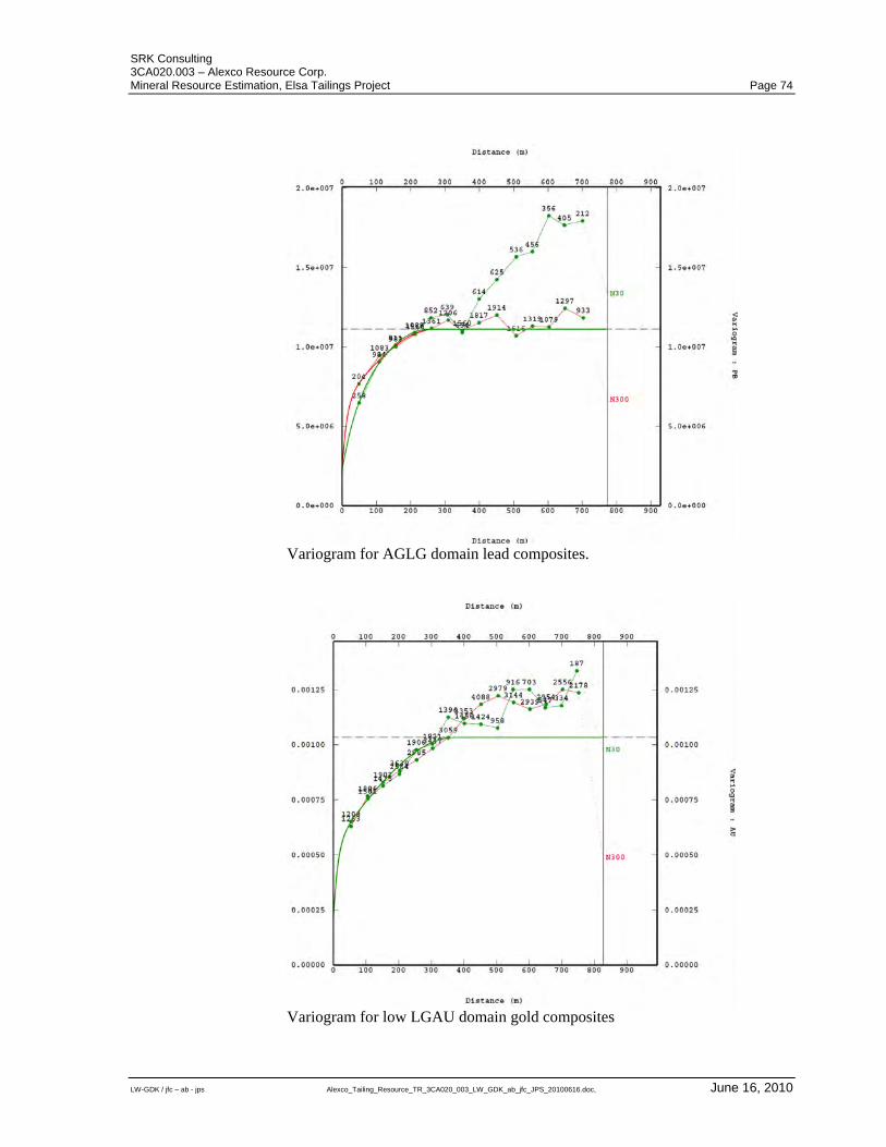
SRK Consulting 3CA020.003 – Alexco Resource Corp. Mineral Resource Estimation, Elsa Tailings Project Page 74
LW-GDK / jfc – ab - jps Alexco_Tailing_Resource_TR_3CA020_003_LW_GDK_ab_jfc_JPS_20100616.doc, June 16, 2010
Variogram for AGLG domain lead composites.
Variogram for low LGAU domain gold composites
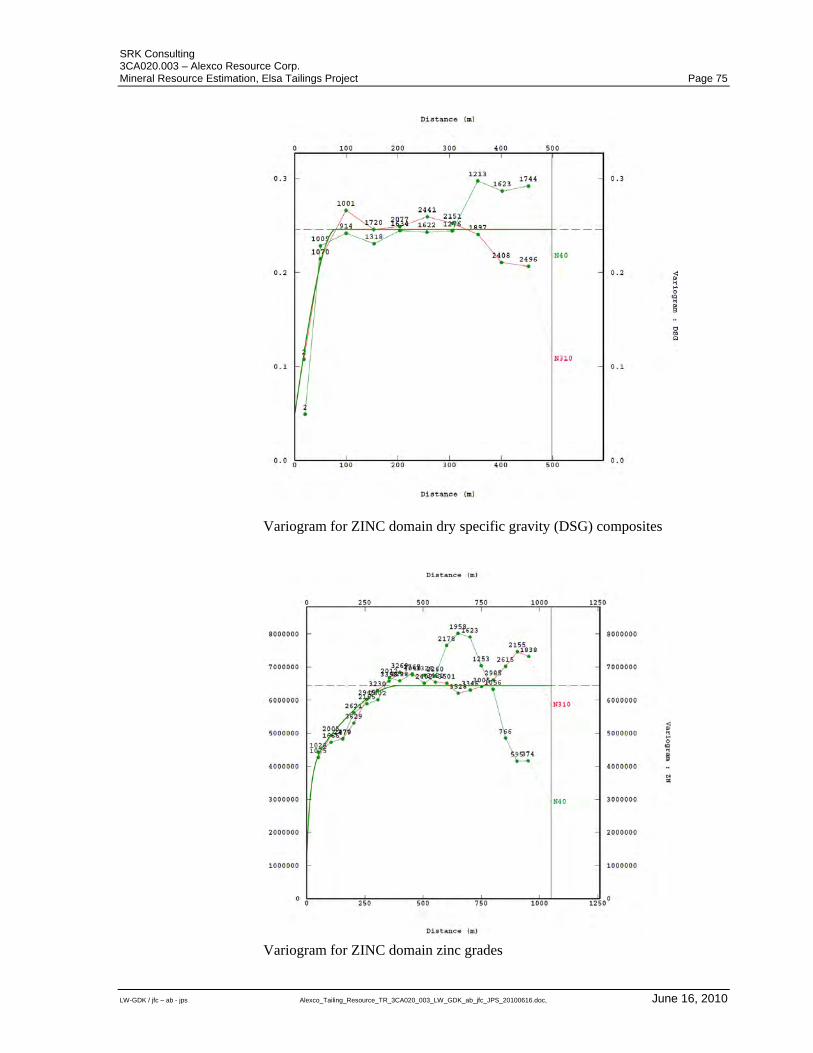
SRK Consulting 3CA020.003 – Alexco Resource Corp. Mineral Resource Estimation, Elsa Tailings Project Page 75
LW-GDK / jfc – ab - jps Alexco_Tailing_Resource_TR_3CA020_003_LW_GDK_ab_jfc_JPS_20100616.doc, June 16, 2010
Variogram for ZINC domain dry specific gravity (DSG) composites
Variogram for ZINC domain zinc grades
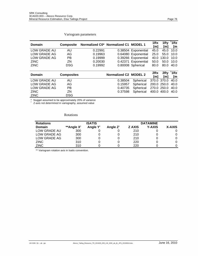
SRK Consulting 3CA020.003 – Alexco Resource Corp. Mineral Resource Estimation, Elsa Tailings Project Page 76
LW-GDK / jfc – ab - jps Alexco_Tailing_Resource_TR_3CA020_003_LW_GDK_ab_jfc_JPS_20100616.doc, June 16, 2010
Variogram parameters
Domain Composite Normalized C0* Normalized C1 MODEL 1 1Rx [m]
1Ry[m]
†1Rz[m
LOW GRADE AU AU 0.22991 0.38504 Exponential 45.0 45.0 10.0LOW GRADE AG AG 0.19963 0.64080 Exponential 25.0 55.0 10.0LOW GRADE AG PB 0.19999 0.39266 Exponential 40.0 130.0 10.0ZINC ZN 0.20030 0.42371 Exponential 50.0 50.0 10.0ZINC DSG 0.19992 0.80008 Spherical 80.0 80.0 40.0
Domain Composites Normalized C2 MODEL 2 2Rx [m]
2Ry[m]
†1Rz[m
LOW GRADE AU AU 0.38504 Spherical 370.0 370.0 40.0LOW GRADE AG AG 0.15957 Spherical 200.0 250.0 40.0LOW GRADE AG PB 0.40735 Spherical 270.0 250.0 40.0ZINC ZN 0.37598 Spherical 400.0 400.0 40.0ZINC DSG
* Nugget assumed to be approximately 20% of variance † Z-axis not determined in variography, assumed value
Rotations
Rotations ISATIS DATAMINE Domain **Angle X' Angle Y' Angle Z' Z AXIS Y-AXIS X-AXISLOW GRADE AU 300 0 0 210 0 0LOW GRADE AG 300 0 0 210 0 0LOW GRADE AG 300 0 0 210 0 0ZINC 310 0 0 220 0 0ZINC 310 0 0 220 0 0
** Variogram rotation axis in Isatis convention.
SRK Consulting 3CA020.003 – Alexco Resource Corp. Mineral Resource Estimation, Elsa Tailings Project Page 77
LW-GDK / jfc – ab - jps Alexco_Tailing_Resource_TR_3CA020_003_LW_GDK_ab_jfc_JPS_20100616.doc, June 16, 2010
CERTIFICATE OF AUTHOR
To accompany the technical report entitled: Mineral Resource Estimation Bellekeno Project, Yukon Territory, Canada dated June 8, 2010.
I, G. David Keller, residing at 255 Richmond Street East, Toronto, Ontario do hereby certify that:
1) I am a Principal Resource Geologist with the firm of SRK Consulting (Canada) Inc. with an office at Suite 2100, 25 Adelaide Street East Toronto, Ontario, Canada;
2) I am a graduate of the University of Calgary in 1986, I obtained a B. Sc. Degree in Geology. I have practiced in the fields of exploration, mine geology and resource estimation in my profession continuously since1986;
3) I am a Professional Geoscientist registered with the Association of Professional Geoscientists of the Province of Ontario (APGO#1235);
4) I have previously reviewed the Keno Hill project in March 2005 to assist Alexco in presenting a qualifying bid for the tender of the project. I have personally inspected the subject property and surrounding areas between August 7 and 9, 2009 for 7 days.
5) I have read the definition of “qualified person” set out in National Instrument 43-101 and certify that by virtue of my education, affiliation to a professional association and past relevant work experience, I fulfill the requirements to be a “qualified person” for the purposes of National Instrument 43-101 and this technical report has been prepared in compliance with National Instrument 43-101 and Form 43-101F1;
6) I, as a qualified person, am independent of the issuer as defined in Section 1.4 of National Instrument 43-101;
7) I am a co-author of this technical report and am responsible for the All sections of the report excluding Section 12.1.2 entitled “Analytical Quality Control Measures”;
8) SRK Consulting (Canada) Inc. was retained by Alexco Resource Corporation. to prepare a technical report for the Elsa Tailings Project in accordance with NI 43-101 and Form 43-101F1 guidelines. The preceding report is based on a site visit, our review of project files and discussions with Alexco Resource Corporation personnel;
9) That, as of the date of this certificate, to the best of my knowledge, information and belief, this technical report contains all scientific and technical information that is required to be disclosed to make the technical report not misleading;
10) I consent to the filing of the technical report with any stock exchange and other regulatory authority;
11) I consent to the filing of the technical report with any stock exchange and other regulatory authority and any publication by them for regulatory purposes, including electronic publication in the public company files on their websites accessible by the public, of the technical report.
Toronto, Canada G. David Keller, P.Geo. June 8, 2010 Principal Resource Geologist
SRK Consulting 3CA020.003 – Alexco Resource Corp. Mineral Resource Estimation, Elsa Tailings Project Page 78
LW-GDK / jfc – ab - jps Alexco_Tailing_Resource_TR_3CA020_003_LW_GDK_ab_jfc_JPS_20100616.doc, June 16, 2010
CERTIFICATE OF AUTHOR
To accompany the technical report entitled: Mineral Resource Estimation Bellekeno Project, Yukon Territory, Canada dated June 8, 2010.
I, Lars Weiershäuser, residing at 44 Juliana Court, Toronto, Ontario do hereby certify that:
1) I am a Senior Consulting Geologist with the firm of SRK Consulting (Canada) Inc. with an office at Suite 2100, 25 Adelaide Street East Toronto, Ontario, Canada;
2) I have graduated from the South Dakota School of Mines and Technology in Rapid City, South Dakota, USA with a M.Sc. in Geology in 2000. I obtained a Ph.D. in Geology from the University of Toronto in Toronto in 2005. I have practiced my profession continuously since 2000;
3) I am a Professional Geoscientist registered with the Association of Professional Geoscientists of the province of Ontario (APGO#1504);
4) I have not visited the subject property;
5) I have read the definition of “qualified person” set out in National Instrument 43-101 and certify that by virtue of my education, affiliation to a professional association and past relevant work experience, I fulfill the requirements to be a “qualified person” for the purposes of National Instrument 43-101 and this technical report has been prepared in compliance with National Instrument 43-101 and Form 43-101F1;
6) I, as a qualified person, am independent of the issuer as defined in Section 1.4 of National Instrument 43-101;
7) I am a co-author of this technical report and am responsible for Section 12.1.2 entitled “Analytical Quality Control Measures”;
8) SRK Consulting (Canada) Inc. was retained by Alexco Resource Corporation. to prepare a technical report for the Bellekeno project in accordance with NI 43-101 and Form 43-101F1 guidelines. The preceding report is based our review of project files and discussions with Alexco Resource Corporation personnel;
9) That, as of the date of this certificate, to the best of my knowledge, information and belief, this technical report contains all scientific and technical information that is required to be disclosed to make the technical report not misleading;
10) I consent to the filing of the technical report with any stock exchange and other regulatory authority;
11) I consent to the filing of the technical report with any stock exchange and other regulatory authority and any publication by them for regulatory purposes, including electronic publication in the public company files on their websites accessible by the public, of the technical report.
Toronto, Canada Lars Weiershäuser, Ph.D, P.Geo. June 8, 2010 Senior Consulting Geologist