Embed Size (px)
Citation preview

Texas Water Development BoardSustainable and affordable water for Texas.Facebook Twitter Flickr Sign up for our updates
Ellenburger-San Saba Aquiferinteractive m ap | cross-section
Summary
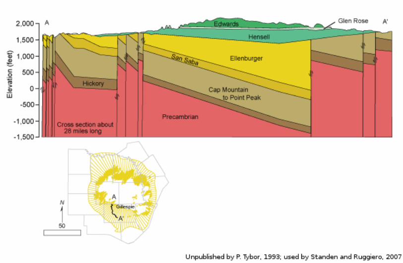
The Ellenburger−San Saba Aquifer is a minor aquifer that is found in parts of 15 counties in the Llano Uplift area ofCentral Texas. The aquifer consists of the Tany ard, Gorman, and Honey cut formations of the Ellenburger Group andthe San Saba Limestone Member of the Wilberns Formation. The aquifer consists of a sequence of limestone anddolomite that crop out in a circular pattern around the Llano Uplift and dip radially into the subsurface away fromthe center of the uplift to depths of approximately 3,000 feet. Regional block faulting has significantlycompartmentalized the aquifer. The maximum thickness of the aquifer is about 2,7 00 feet. Water is held infractures, cav ities, and solution channels and is commonly under confined conditions. The aquifer is highlypermeable in places, as indicated by wells that y ield as much as 1 ,000 gallons per minute and springs that issuefrom the aquifer, maintaining the base flow of streams in the area.
Water produced from the aquifer is inherently hard and usually has less than 1 ,000 milligrams per liter of totaldissolved solids. Fresh to slightly saline water extends downdip to depths of approximately 3,000 feet. Elevatedconcentrations of radium and radon also occur in the aquifer.
Most of the groundwater is used for municipal purposes, and the remainder for irrigation and livestock. A largeportion of water flowing from San Saba Springs, which is the water supply for the city of San Saba, is thought to befrom the Ellenburger−San Saba and Marble Falls aquifers.
Reports
ID Date T y pe Description
AA08-03_MAG
12/10/2009AquiferassessmentMAG
Managed available groundwater estimates for the Ellenburger-SanSaba Aquifer in Groundwater Management Area 8
AA08-08 8/31/2010Aquiferassessment
Desired future condition scenarios for the Ellenburger-San SabaAquifer in Groundwater Management Area 7
AA10-01_MAG 6/22/2011AquiferassessmentMAG
Managed available groundwater estimates for the Ellenburger-SanSaba Aquifer in Groundwater Management Area 9
AA10-04 9/10/2010Aquiferassessment
Desired future condition scenarios for the Ellenburger-San SabaAquifer in Groundwater Management Area 7
AA10-10_MAG 11/1/2011AquiferassessmentMAG
Modeled available groundwater for the Ellenburger-San Saba Aquiferin Groundwater Management Area 7
AA10-15_MAG 12/30/2011AquiferassessmentMAG
Modeled available groundwater estimates for the Ellenburger-SanSaba Aquifer in Groundwater Management Area 8
B-6310 12/1/197 3Groundwaterbulletin
Reconnaissance Investigation of the Ground-Water Resources of theBrazos River Basin, Texas
B-6519 8/1/1965Groundwaterbulletin
Ground-Water Conditions in Menard County , Texas
CR-1004831116
7 /11/2012Contractreport
Aquifer Test and Related Well Information from Public Water SupplyWells in Groundwater Management Area 8
GMA7 _DFC_01 7 /29/2010DFCsubmission
Desired future conditions for the Capitan Reef Complex, Dockum,Edwards-Trinity (Plateau), Ellenburger-San Saba, Hickory , Lipan,

GMA7 _DFC_01 7 /29/2010submission
Edwards-Trinity (Plateau), Ellenburger-San Saba, Hickory , Lipan,Marble Falls, Ogallala, and Rustler aquifers
GMA8_DFC_02 5/19/2008DFCsubmission
Desired future conditions for the Ellenburger-San Saba, Hickory , andMarble Falls aquifers
GMA8_DFC_05 4/27 /2011DFCsubmission
Desired future conditions for the Blossom, Brazos River Alluv ium,Edwards (Balcones Fault Zone), Ellenburger-San Saba, Hickory ,Marble Falls, Nacatoch, Trinity , and Woodbine aquifers
GMA9_DFC_01 8/29/2008DFCsubmission
Desired future conditions for the Edwards Group of the Edwards-Trinity (Plateau), Ellenburger-San Saba, Hickory , and Marble Fallsaquifers
R-046 5/1/1967TWDBnumberedreport
Occurrence and Quality of Ground Water in Brown County , Texas
R-057 9/1/1967TWDBnumberedreport
Occurrence and Quality of Ground Water in Coleman County , Texas
R-17 4 7 /1/197 3TWDBnumberedreport
Ground-Water Resources of Blanco County , Texas
R-235 7 /1/197 9TWDBnumberedreport
Occurrence, Availability , and Chemical Quality of Ground Water inthe Edwards Plateau Region of Texas
R-339 8/1/1992TWDBnumberedreport
Evaluation of Ground-Water Resources of the Paleozoic andCretaceous Aquifers in the Hill Country of Central Texas
R-346 3/1/1996TWDBnumberedreport
The Paleozoic and Related Aquifers of Central Texas
R-360 2/9/2004TWDBnumberedreport
Conference Proceedings: Aquifers of the Edwards Plateau
R-380 7 /1/2011TWDBnumberedreport
Aquifers of Texas
T exas Water Developm ent Board, 17 00 North Congress Avenue, Austin, TX 7 87 01 | TEL: 512-463-7 847
Governm ent Resources:Texas.govTRAILVeterans Portal
American Recovery and Reinvestment ActTNRISWater IQWIID Sy stemSave Texas WaterTWICCWater ExplorationTexas Water SmartWater Data for Texas