Embed Size (px)
Citation preview
1
4th IASPEI / IAEE International Symposium:
Effects of Surface Geology on Seismic Motion August 23–26, 2011 · University of California Santa Barbara
SEISMOMETRIC RECORDING OF HYPOGEOUS FAILURES DUE TO A ROCK MASS SPREADING IN CENTRAL APENNINES (ITALY)
Luca LENTI Salvatore MARTINO Antonella PACIELLO IFSTTAR CERI- Dip. Scienze della Terra ENEA Paris East University University of Rome “Sapienza” R.C. Roma, Casaccia France Italy Italy Alberto PRESTININZI Stefano RIVELLINO CERI- Dip. Scienze della Terra CERI University of Rome “Sapienza” University of Rome “Sapienza” Italy Italy ABSTRACT Data from the seismometric monitoring of a rock mass spreading which involves a karstified slope located in Central Apennines (Italy) are here presented. The evolutionary model of the slope, supported by field observations and the data from stress-strain monitoring systems, show active deformations. Starting from September 4th, 2008 an accelerometric network was installed within the slope. More than 1000 events were recorded, both earthquakes and not seismic events, these last ones classified in: i) vibrational emissions, due to both cracking and sliding on pre-existing joints; ii) collapses, consisting in dislodgement of blocks from hypogeous caves. A specific software was implemented to distinguish the events on the basis of their physical properties (i.e. energy, time duration, kinetic parameters and frequency content). The PGA attenuation of the not seismic events results to be in good agreement with the engineering-geological model of the slope which indicates an eastern sector widespread characterized by an intensely jointed rock mass and a western one characterized by concentration of hypogeous caves, only along released bands of highly jointed rock mass. The frequencies of occurrence of earthquakes and of hypogeous failures are generally strongly correlated; nevertheless, many hypogeous instabilities result directly associated to the continuous slope deformations.
INTRODUCTION The carbonate Italian Central Apennines show evidence of large-scale gravity-induced slope deformations which are favoured by the complex thrust and fold structure (Argnani & Ricci Lucchi, 2001; Vai, 2001) responsible for the frequent juxtaposition of lithotypes with different geomechanical behaviour as well as the occurrence of tectonic elements (Bianchi Fasani et al., 2011; Discenza et al., 2011). These slope deformations may become catastrophic and generate particularly intense events (high velocities and volumes), as testified by paleo-huge landslides such as the Lettopalena (Scarascia Mugnozza et al., 2006), the Campo di Giove (Di Luzio et al., 2004) and the Scanno (Petitta et al., 2010) rock avalanches. The need thus arises for acquiring a better understanding of these phenomena, describing their geological-evolutionary context and analysing their dynamics and kinematics. Scenarios of failure involving rock masses can be associated with impulsive triggers (i.e. explosions, collapses) or earthquakes. In these cases precursors do not necessarily occur, while the events representing possible triggers can be monitored. However the observation of these trigger events is not enough for mitigating geological risks if neither trigger intensity thresholds nor delay times of the induced rock mass failure can be established. Some experiments have been performed in mines or in landslide areas that were aimed at monitoring failure precursors by use of acoustic as well as seismometric devices (Miller et al., 1989; Lei et al., 2004; Lai et al., 2006; Deparis et al., 2008). On the other hand hypogeous instabilities triggered by impulsive events were recorded during experiments of controlled explosions and collapses of caves in mine areas (Phillips et al., 1997; Yang et al., 1998). Moreover, laboratory tests were performed on brittle materials to analyze
2
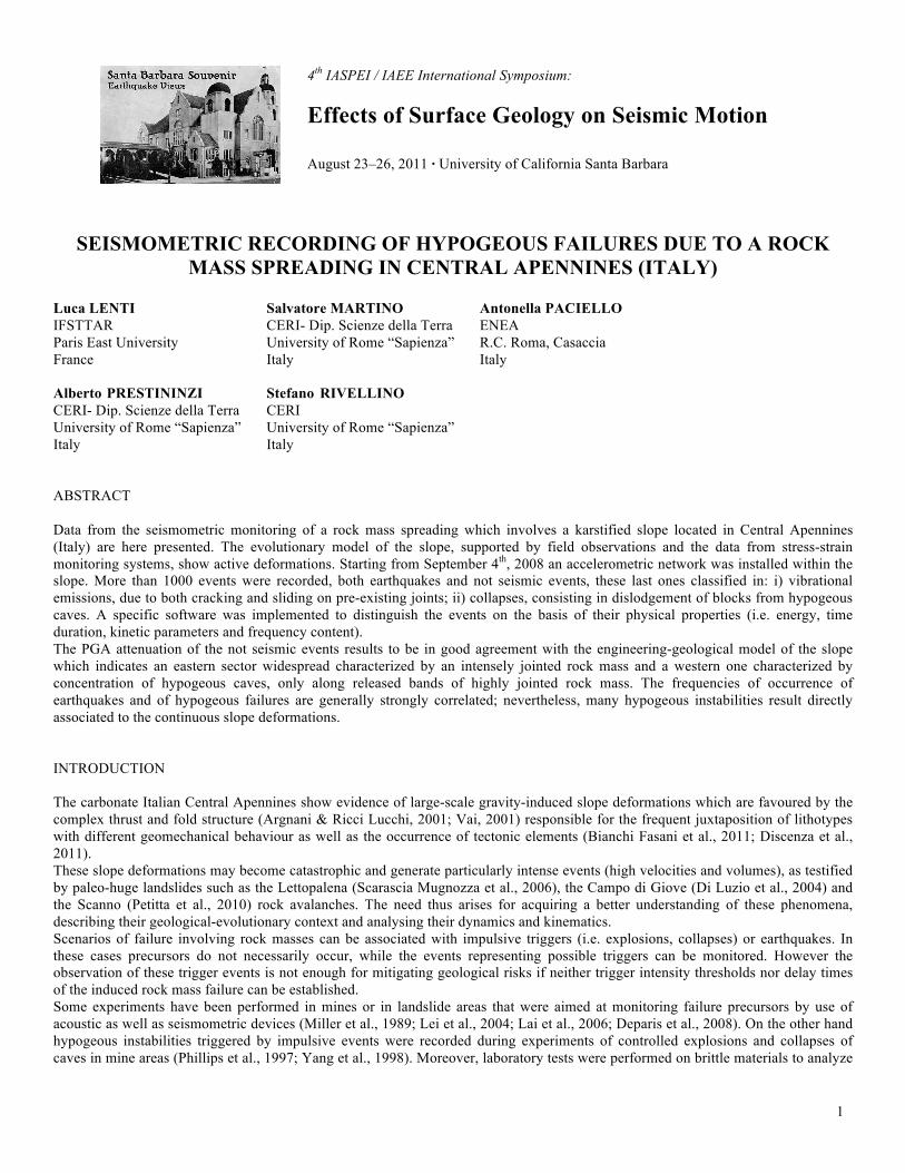
possible correlations between acoustic emissions and observed microfracturing (Ganne et al., 2007) as well as to derive theoretical models of wave interaction with opened fractures in rocks to be applied in numerical modelling (Eberhardt, 1998; Hildyard, 2007). Characteristic waveforms and frequency spectral features of microseismic emissions due to rock falls, collapses and explosions, both natural and artificially induced, were collected and analysed by many authors (Miller et al., 1989; Phillips et al., 1997; Heng, 2009). On the whole, these studies proved that only a specific comparison among signals generated by different events (i.e. among natural events or among natural and artificial ones) allows a reliable discrimination. The analysis of sequences of precursors as well as of post-failure events (i.e. hypogeous instabilities induced by impulsive triggers) can be considered a very useful tool for managing early preventive interventions, since monitoring the phases of failure propagation provides information on the changes which are involving the rock mass, but also on possible occurrence of more critical conditions (i.e. generalized collapse). This study used a seismometric monitoring system to record precursors, post-failure events and triggering impulsive events within a karstified slope located in Central Apennines, about 80 km far from Rome. The evolutionary model of the slope, supported by field observations and the data from stress-strain monitoring systems, shows active deformations. The landforms associated to these gravitational phenomena were recently mapped by the use of a LIDAR radar remote survey as well as by in-field observations and are indicative of slow, intense and pervasive slope-scaled gravitational deformations, ascribable to different evolutionary stages. The devised geological-evolutionary model of the slope reflects a complex deep-seated gravitational deformation, which initiates as a sackung phenomenon and continuously evolves from a rock mass spreading to a rock-block mass deformation (Martino et al., 2004). The recorded sequences of the earthquakes as well as of the induced failures within the rock mass were analysed with the aim of evaluating possible trigger thresholds and recognising different levels of attention, based on the observed trends of events. GEOLOGICAL SETTING OF THE PESCHIERA SPRING SLOPE The Peschiera Springs slope corresponds to the south-western flanks of Mt. Nuria (Central Apennines, Italy) and is composed of Malm - Lower Cretaceous limestones (Ciotoli et al., 2001) (Fig.1). The structural setting of the slope is monoclinic, with EW-trending and N-dipping (30°-40°) strata; many fault lines cross the slope with roughly NS and N35E trends (Fig. 1).
Fig. 1 . a) Panoramic photo-view of the Peschiera Spring slope; b) Geological sketch of the Peschiera Springs slope: (1) Recent alluvial deposits; (2) Reddish soils; (3) Slope debris; (4) Gravel and conglomerate (upper Pliocene part–lower Pleistocene part); (5)
Sandy-clayey flysch (upperMiocene); (6) Marly limestone (upper Cretaceous–lower Miocene); (7) Micritic Limestone (lower Cretaceous); (8) Coral limestone (upper Malm); (9) Coral and echinids limestone (Malm part); (10) Fault (dashed if supposed):
FMF—Fiamignano-Micciani Fault, CF— Canalone Fault, PF—Pendenza Fault; (11) Strike and dip of strata; (12) Spring.

3
The slope also hosts a major karst aquifer which represents the drainage system of the Nuria-Velino-western Fucino and western Marsica (Velino-Sirente) mountains (total surface area: 1016 km2), whose main springs are the Peschiera-Canetra ones (measured total discharge: roughly 18 to 21 m3/s; Boni et al., 1995). Through geomorphological surveys as well as a recent digital, high-resolution (2 m), elevation model of the slope derived by a LIDAR (Light Detection And Ranging) radar remote survey, numerous gravity-induced morphological elements (e.g. scarps, trenches, sinkholes and tension cracks) were identified (Fig.2). These landforms are indicative of slow, intense and pervasive slope deformations, which affect the entire slope and which correspond to various evolutionary stages ascribable to different portions of the slope, as proved by already published outputs of a stress-strain monitoring system installed within the drainage plant (Martino et al., 2004; Maffei et al., 2005).
Fig. 2 . Digital Elevation Model (DEM) from the LIDAR flight with main geomorphological features; 1) Trench; 2) Tension crack; 3) Sinkhole; 4) Scarp; 5) Karstified flat; 6) Fault; 7) Gully; 8) Slope debris; 9) Debris fan deposit; 10) Accelerometric station wihin the
drainage plant; 11) Reference point for the azimuthal distribution of the time integral of the square velocity, derived from seismic noise records; 12) Velocimetric station of seismic noise within the drainage plant.
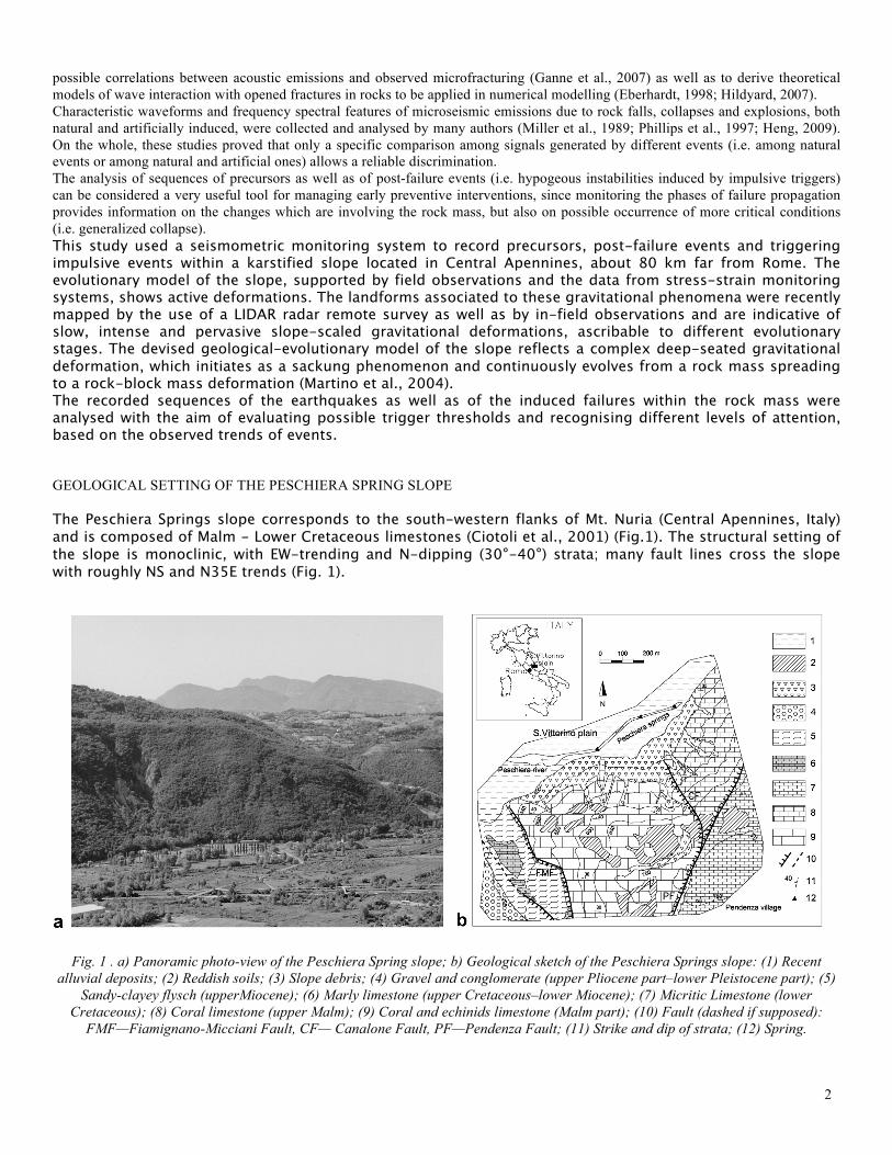
Many scarps (with a height varying from 5 up to 15 m) are arranged both longitudinally and transversely to the slope. Tens of sinkholes and depressions of variable size (diameter: 5 m to about 15 m; depth: 0.5 m to about 9 m) can be observed all along the slope; sometimes aligned along opened tension cracks. All the collected gemorphological evidences enabled the recognition of three slope sectors with ongoing gravity-induced processes at different evolutionary stages (Martino et al., 2004): i) a sector, including the southern portion of the slope and its top, with evidence of incipient, but limited deformation, in their early evolutionary stages; ii) a western sector, with evidence of mature, but not yet advanced evolution of gravity-induced deformations, where the major deformations are concentrated near the most marked gravity-induced elements and iii) an eastern sector, with evidence of advanced evolution characterised by pervasive deformation and pronounced gravity-induced elements, such as scarps, trenches and sinkholes. The geological-evolutionary model of the slope reflects a complex deep-seated gravitational deformation, which initiates as a rock mass creep (Chigira, 1992) and continuously evolves from a rock mass spreading to a rock-block mass deformation (Martino et al., 2004). In particular, the rock mass spreading can be clearly observed in the western portion of the slope (Fig.3). SEISMIC NOISE AND DISSIPATIVE EFFECTS
4
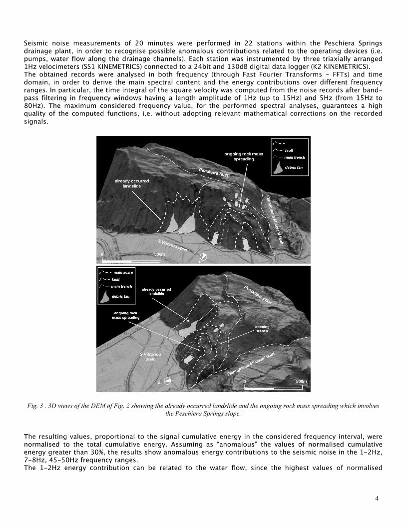
Seismic noise measurements of 20 minutes were performed in 22 stations within the Peschiera Springs drainage plant, in order to recognise possible anomalous contributions related to the operating devices (i.e. pumps, water flow along the drainage channels). Each station was instrumented by three triaxially arranged 1Hz velocimeters (SS1 KINEMETRICS) connected to a 24bit and 130dB digital data logger (K2 KINEMETRICS). The obtained records were analysed in both frequency (through Fast Fourier Transforms - FFTs) and time domain, in order to derive the main spectral content and the energy contributions over different frequency ranges. In particular, the time integral of the square velocity was computed from the noise records after band- pass filtering in frequency windows having a length amplitude of 1Hz (up to 15Hz) and 5Hz (from 15Hz to 80Hz). The maximum considered frequency value, for the performed spectral analyses, guarantees a high quality of the computed functions, i.e. without adopting relevant mathematical corrections on the recorded signals.
Fig. 3 . 3D views of the DEM of Fig. 2 showing the already occurred landslide and the ongoing rock mass spreading which involves the Peschiera Springs slope.
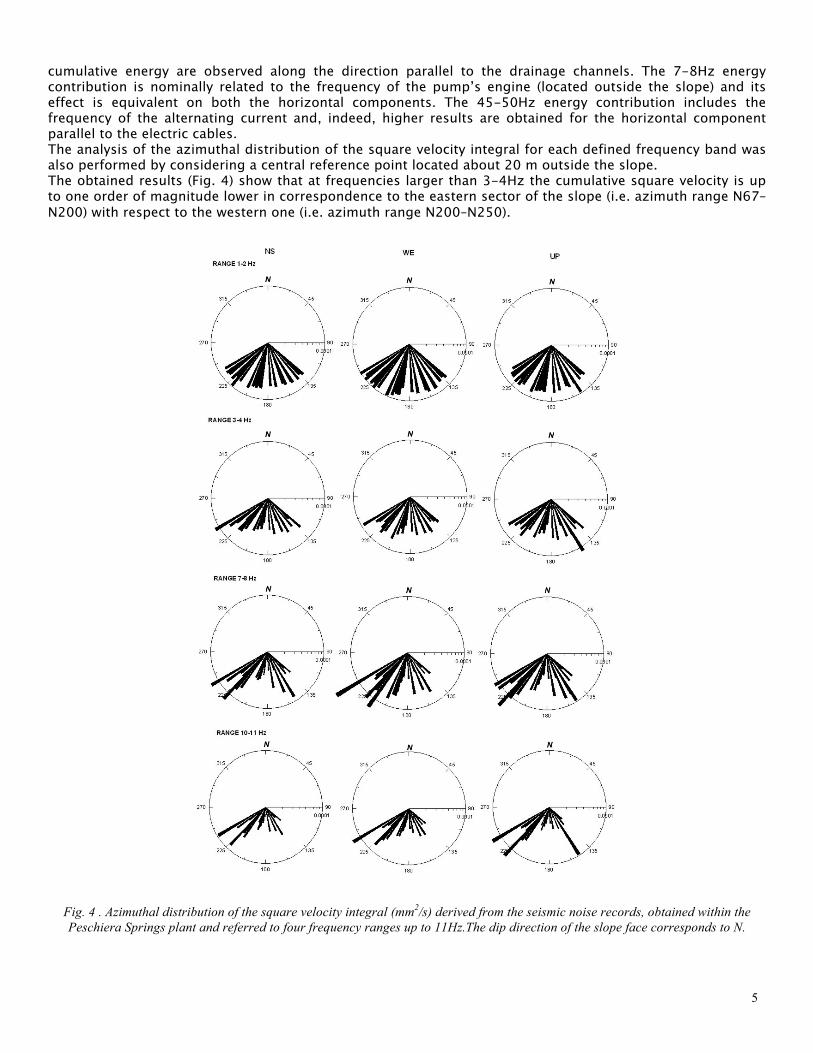
The resulting values, proportional to the signal cumulative energy in the considered frequency interval, were normalised to the total cumulative energy. Assuming as “anomalous” the values of normalised cumulative energy greater than 30%, the results show anomalous energy contributions to the seismic noise in the 1-2Hz, 7-8Hz, 45-50Hz frequency ranges. The 1-2Hz energy contribution can be related to the water flow, since the highest values of normalised
5
cumulative energy are observed along the direction parallel to the drainage channels. The 7-8Hz energy contribution is nominally related to the frequency of the pump’s engine (located outside the slope) and its effect is equivalent on both the horizontal components. The 45-50Hz energy contribution includes the frequency of the alternating current and, indeed, higher results are obtained for the horizontal component parallel to the electric cables. The analysis of the azimuthal distribution of the square velocity integral for each defined frequency band was also performed by considering a central reference point located about 20 m outside the slope. The obtained results (Fig. 4) show that at frequencies larger than 3-4Hz the cumulative square velocity is up to one order of magnitude lower in correspondence to the eastern sector of the slope (i.e. azimuth range N67–N200) with respect to the western one (i.e. azimuth range N200–N250).
Fig. 4 . Azimuthal distribution of the square velocity integral (mm2/s) derived from the seismic noise records, obtained within the Peschiera Springs plant and referred to four frequency ranges up to 11Hz.The dip direction of the slope face corresponds to N.
6
This evidence shows that the more intense jointing conditions of the rock mass, observed in the eastern portion of the slope and due to a more evolved stage of the gravitational process (Martino et al., 2001; Martino et al., 2004), are responsible for higher dissipative effects in seismic wave propagation.
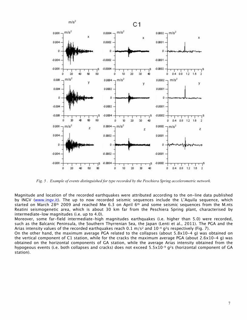
ACCELEROMETRIC RECORDS Starting from September 4th, 2008 four accelerometric stations (GA, C1, F1 and C6 of Fig.2) were installed by ACEA-ATO2 S.p.A. within the drainage plant of the Peschiera Springs in order to record both seismic events and hypogeous collapses. Each station was instrumented by a triaxial accelerometer (EPISENSOR KINEMETRICS) directly installed on bedrock. The four accelerometers were connected via cable to a digital data-logger (K2 KINEMETRICS) set to the absolute local time by a GPS device. The monitoring system was managed by the Research Centre for Geological Risks (CERI) of the University of Rome “Sapienza” in order to properly set the recording device, analyze the collected data and suggest possible plans of management in case of a seismic crisis or a sequence of hypogeous events. Two pass-band filters of the KINEMETRICS library (“classic strong motion” with a pass-band about 1-10Hz and “IIRC” with a band-pass about 1-20Hz) were alternatively applied to the channels of each station. Moreover, some channels were set with a threshold trigger fixed according to their noise level, while others were set in STA/LTA (short time amplitude/long time amplitude) trigger mode, which is particularly devoted to the detection of low-magnitude earthquakes. Until the end of March 2009 only 7 events were recorded within the slope, but from April 2009, until May 2011 more than 1000 events (about 800 earthquakes and 300 hypogeous instabilities) were recorded on the whole. To distinguish among different kinds of recorded events, a specific software was implemented through SAC (Seismic Analysis Code) and Fortran codes on Unix platform, taking into account the records obtained from the accelerometric network as well as the data collected by use of a temporary velocimetric array, which operated within the plant for about 5 months. The software allows to classify the events on the basis of their physical properties (i.e. energy, time duration, kinetic parameters and frequency content) and, in particular, to recognise among earthquakes, cracks and hypogeous collapses (Figs. 5, 6).
7
Fig. 5 . Example of events distinguished for type recorded by the Peschiera Spring accelerometric network.
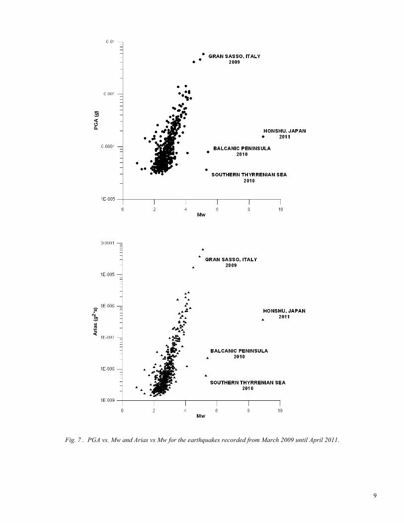
Magnitude and location of the recorded earthquakes were attributed according to the on-line data published by INGV (www.ingv.it). The up to now recorded seismic sequences include the L’Aquila sequence, which started on March 28th 2009 and reached Mw 6.3 on April 6th and some seismic sequences from the M.nts Reatini seismogenetic area, which is about 30 km far from the Peschiera Spring plant, characterised by intermediate-low magnitudes (i.e. up to 4.0). Moreover, some far-field intermediate-high magnitudes earthquakes (i.e. higher than 5.0) were recorded, such as the Balcanic Peninsula, the Southern Thyrrenian Sea, the Japan (Lenti et al., 2011). The PGA and the Arias intensity values of the recorded earthquakes reach 0.1 m/s2 and 10-4 g2s respectively (Fig. 7). On the other hand, the maximum average PGA related to the collapses (about 5.8x10⁻⁴ g) was obtained on the vertical component of C1 station, while for the cracks the maximum average PGA (about 2.6x10⁻⁴ g) was obtained on the horizontal components of GA station, while the average Arias intensity obtained from the hypogeous events (i.e. both collapses and cracks) does not exceed 5.5x10⁻⁹ g2s (horizontal component of GA station).
8
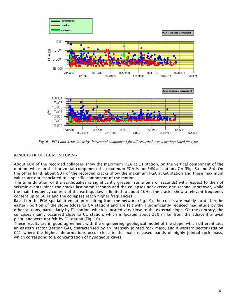
Fig. 6 . PGA and Arias intensity (horizontal component) for all recorded events distinguished for type.
RESULTS FROM THE MONITORING About 60% of the recorded collapses show the maximum PGA at C1 station, on the vertical component of the motion, while on the horizontal component the maximum PGA is for 54% at stations GA (Fig. 8a and 8b). On the other hand, about 90% of the recorded cracks show the maximum PGA at GA station and these maximum values are not associated to a specific component of the motion. The time duration of the earthquakes is significantly greater (some tens of seconds) with respect to the not seismic events, since the cracks last some seconds and the collapses not exceed one second. Moreover, while the main frequency content of the earthquakes is limited to about 10Hz, the cracks show a relevant frequency content up to 60Hz and the collapses reach higher frequencies. Based on the PGA spatial attenuation resulting from the network (Fig. 9), the cracks are mainly located in the eastern portion of the slope (close to GA station) and are felt with a significantly reduced magnitude by the other stations, particularly by F1 station, which is located very close to the external slope. On the contrary, the collapses mainly occurred close to C1 station, which is located about 250 m far from the adjacent alluvial plain, and were not felt by F1 station (Fig. 10). These results are in good agreement with the engineering-geological model of the slope, which differentiates an eastern sector (station GA), characterised by an intensely jointed rock mass, and a western sector (station C1), where the highest deformations occur close to the main released bands of highly jointed rock mass, which correspond to a concentration of hypogeous caves.
9
Fig. 7 . PGA vs. Mw and Arias vs Mw for the earthquakes recorded from March 2009 until April 2011.

10
a) b)
Fig. 8 . a) Distribution of the maximum PGA (horizontal component) at the recordings station referred to 30 recorded collapses; b) Distribution of the maximum PGA (horizontal component) at the recordings station referred to 270 recorded cracks.
Fig. 9. Distribution of PGA attenuation respect to stations C1, F1 and C6, referred to the recorded crack events which were characterised by a maximum PGA at station GA (horizontal component).
Fig. 10 . Distribution of PGA attenuation respect to stations GA, F1 and C6, referred to the 30 recorded collapses which were characterised by a maximum PGA at station C1 (vertical component).

11
These findings are also in good agreement with the evolutionary model of the deformational processes affecting the slope, since the crack events are mainly located in the eastern portion of the slope (which is involved in the rock block mass deformations), while all the recorded collapses are located in its western portion (which is involved in the rock mass spreading). Moreover, it is possible to state that the collapses occurred in a sub-water system (i.e. below the water table), since a relevant difference (up to twice) in terms of PGA is generally observed by comparing the vertical component of the motion with the horizontal ones. These events can be therefore related to the presence of hypogeous caves, generated by limestone dissolution in the karst aquifer. In general, the frequencies of occurrence of the seismic sequences and of the hypogeous instabilities are strongly correlated, even though many hypogeous instabilities can be associated to the continuous slope deformations since their frequency increasing cannot be directly related to seismic events. In this regard the hypogeous instabilities recorded during the April-May 2010 time interval are not related to any seismic event/sequence while they occurred some week before the Reatini M.nts sequence of September 2010. “Transgressive”, “progressive” and “regressive” sequences of hypogeous instabilities (Szwedzicki, 2001; 2003) respectively correspond to an increasing-rate trend (i.e. the same observed during the first 5 days after L’Aquila mainshock until April 10th, 2009); to a constant-rate trend (i.e. the one observed during the three weeks from April 10th, 2009 until April 30th, 2009), to a decreasing-rate trend (i.e. the one observed from the end of April 2009 until the end of August 2009).
Fig.11 – Sequential analysis of the events recorded within the Peschiera Springs slope in the time interval 28th March 2009 – 25st April 2011: Time intervals characterised by different trends of cumulative of Arias intensity (AI) and corresponding to different
attention levels for the plant‘s management. These results highlight the reliability of the seismometric monitoring for evaluating an increasing intensity of the gravitational deformations affecting the rock mass slope as well as for relating it to “external” dynamic actions (i.e. earthquakes). Moreover the observed different trends of sequences of hypogeous failures point out that a single event is not necessary related to the gravitational evolution of the slope, while, on the contrary, sequences of events well represent the rock mass response to transient actions, such as earthquakes, as well as to stationary conditions (i.e. gravity, ground water flow). For this reason it seems that the recordable sequences of hypogeous instabilities are more representative for the on-going deformational processes affecting the slope. The transgressive, progressive and regressive sequences of hypogeous instabilities referred to the hypogeous failures suggest different proceedings to manage the geological risk of the drainage plant, i.e. referred to “alarm”, “alert” and “awareness” levels of attention, respectively. Moreover, the installed seismometric monitoring system can be regarded up to now as a unique valid solution for monitoring the Peschiera slope gravitational deformation since no records of superficial displacements are reliable as an effect of the very low strain rate affecting the mass rock creep, the wood cover all over the slope and the widespread outcropping of shallow debris as well as of
12
thicker residual deposits. REFERENCES Argnani, A., and F. Ricci Lucchi, F. [2001], “Tertiary silicoclastic turbidite systems of the Nothern Apennines”. In: Vai, G. B. & Martini, I. P. (eds) Anatomy of an Orogen: the Apennines and Adjacent Mediterranean Basins. Kluwer Academic Publishers, 327–350. Bianchi Fasani, G., Di Luzio, E., Esposito, C., Martino, S., and G. Scarascia Mugnozza [2011], “Numerical modelling of Plio-Quaternary slope evolution based on geological constraints: a case study from the Caramanico valley (Central Apennines, Italy)”, In: Jaboyedoff M. (Ed.), Slope Tectonics. Geological Society, London, Special Publications, 351, 201–214. DOI: 10.1144/SP351.11. Boni, C.F., Capelli, G., and M. Petitta [1995], “Carta idrogeologica dell‘alta e media Valle del F. Velino”, Elaborazione cartografica e stampa System Cart, Roma. Chigira, M., [1992], “Long-term gravitational deformation of rocks by mass rock creep”, Engineering Geology. 32, 157–184. Ciotoli, G., Di Filippo, M., Nisio, S. and C. Romagnoli [2001], “La Piana di S.Vittorino:dati preliminari sugli studi geologici, strutturali, geomorfologici, geofisici e geochimici”, Mem. Soc. Geol. It. 56, 297-308. Deparis, J., Jongmans, J., Cotton, F., Bailler, L., Thouvenot, F. and D. Hantz [2008], “Analysis of rock-fall and rock-fall avalanche seismograms in the French Alps”, Bull. Seism. Soc. Am. 98(2), 1781-1796. Di Luzio, E., Bianchi Fasani, G., Esposito, C., Saroli, M., Cavinato, G.P., and G. Scarascia Mugnozza [2004], “Massive rock-slope failure in the Central Apennines (Italy): the case of the Campo di Giove rock avalanche”. Bullettin of Engineering Geology and the Environment, 63: 1-12. Discenza, M.E., Esposito, C., Martino, S., Petitta, M., Prestininzi, A., Scarascia Mugnozza, G.: [2011], The gravitational slope deformation of Mt. Rocchetta ridge (central Apennines, Italy): geological-evolutionary model and numerical analysis. Bull Eng Geol Environ. DOI 10.1007/s10064-010-0342-7. Eberhardt, E., Stead, D., Stimpson, B., and R.S. Read, [1998], “Identifying crack initiation and propagation thresholds in brittle rock”, Can. Geotech. J. 35, 222-233. Ganne, P., Vervoort, A. and M. Wevers, M. [2007], “Quantification of pre-peak brittle damage: Correlation between acoustic emission and observed micro-fracturing”, International Journal of Rock Mechanics & Mining Sciences 44, 720–729. Heng, I.S. [2009], “Rotating stellar core-collapse waveform decomposition: a principal component analysis approach”. Class. Quantum Grav. 26, 105005. Hildyard, M.W. [2007], “Manuel Rocha Medal Recipient Wave interaction with underground openings in fractured rock”, Rock Mech Rock Engng 40, 531–561. INGV [2009], “La sequenza sismica dell‘Aquilano, Aprile 2009”, Web site: http://portale.ingv.it/primo-piano/archivio-primo-piano/notizie-2009/terremoto-6-aprile/copy_of_la-sequenza-sismica-dell-aquilano-aprile-2009/ Lai, X.P., Cai, M.F. and M.W. Xie [2006], “In situ monitoring and analysis of rock mass behaviour prior to collapse of the main transport roadway in Linglong Gold Mine, China”. International Journal of Rock Mechanics & Mining Sciences 43, 640–646. Lei, X., Masuda, K., Nishizawa, O., Jouniaux, L., Liu, L.,Ma W., Satoh T. and K. Kusunose [2004], “Detailed analysis of acoustic emission activity during catastrophic fractureof faults in rock”, Journal of Structural Geology 26, 247–258. Lenti, L., Martino, S., Paciello, A., Prestininzi, A., and R. Romeo, R. [2011], “Insights into the ground motion records of the Honshu (Japan) earthquake of 11 March 2011”, Italian Journal of Engineering Geology and Environment, 1(2011), 5-16.

13
Maffei, A., Martino, S. and A. Prestininzi [2005], “From the geological to the numerical model in the analysis of the gravity-induced slope deformations: an example from the Central Apennines (Italy)”, Engineering Geology 78, 215-236. Martino, S., Prestininzi, A. and G. Scarascia Mugnozza [2001], “Deep seated gravitational deformations: parameters from laboratory testing for analogical and numerical modelling”, Proc. EUROCK 2001, Espoo – Finland: Rock Mechanics, a challenge for society, Balkema ed., 137-142. Martino, S., Prestininzi, A. and G. Scarascia Mugnozza [2004], “Geological evolutionary model of a gravity-induced slope deformation in the carbonate central Apennines (Italy)”, Quarterly Journal of Engineering Geology and Hydrogeology 37(1), 31-47. Miller, A., Richards, J. A., McCann, D.M., Browitt, C.W.A. and P.D. Jackson [1989], “Microseismic techniques for monitoring incipient hazardous collapse conditions above abandoned limestone mines”, Quarterly Journal of Engineering Geology, 22, 1-18. Petitta, M., Scarascia Mugnozza, G, Barbieri, M., Bianchi Fasani, G., and C. Esposito [2010], “Hydrodynamic and isotopic investigations for evaluating the mechanisms and amount of groundwater seepage through a rockslide dam”, Hydrological Processes, 24, pp. 3510-3520. DOI: 10.1002/hyp.7773. Phillips, W.S., Pearson, D.C., Edwards C. L. and B.W. Stump [1997], “Microseismicity Induced by a Controlled, Mine Collapse at White Pine, Michigan”, International Journal of Rock Mechanics & Mining Sciences 34 (314), paper 246. Scarascia Mugnozza, G., Bianchi Fasani, G., Esposito, C., Martino, S., Saroli, M., Di Luzio, E., and S.G. Evans [2006], “Rock avalanche and mountain slope deformation in a convex dip-slope: the case of the Maiella massif (Central Italy)”, In: Evans S.G., Scarascia Mugnozza G., Strom A., Hermanns R. (Eds.), Landslide from Massive Rock Slope Failure, Proceedings of the NATO Advanced Research Workshop on Massive Rock Slope Failure: New Models for Hazard Assessment, Celano, Italy, 16-21 June 2002. Series: NATO Science Series: IV: Earth and Environmental Sciences, Vol. 49. Springer, The Netherlands, pp. 357-376. ISBN: 978-1-4020-4036-8 Szwedzicki, T. [2001], “Geotechnical precursors to large-scale ground collapse in mines”, International Journal of Rock Mechanics & Mining Sciences 38, 957–965. Szwedzicki, T. [2003], “Rock mass behaviour prior to failure”, International Journal of Rock Mechanics & Mining Sciences 40, 573–584. Vai, G.B. [2001], “Structure and stratigraphy – an overview”, In: Vai, G. B. & Martini, I. P. (eds) Anatomy of an Orogen: the Apennines and Adjacent Mediterranean Basins. Kluwer Academic Publishers. Yang, X., Stump, B.W., and W.S. Phillips [1998], “Source Mechanism of an Explosively Induced Mine Collapse”, Bulletin of the Seismological Society of America, 88(3), 843-854.