Embed Size (px)
Citation preview
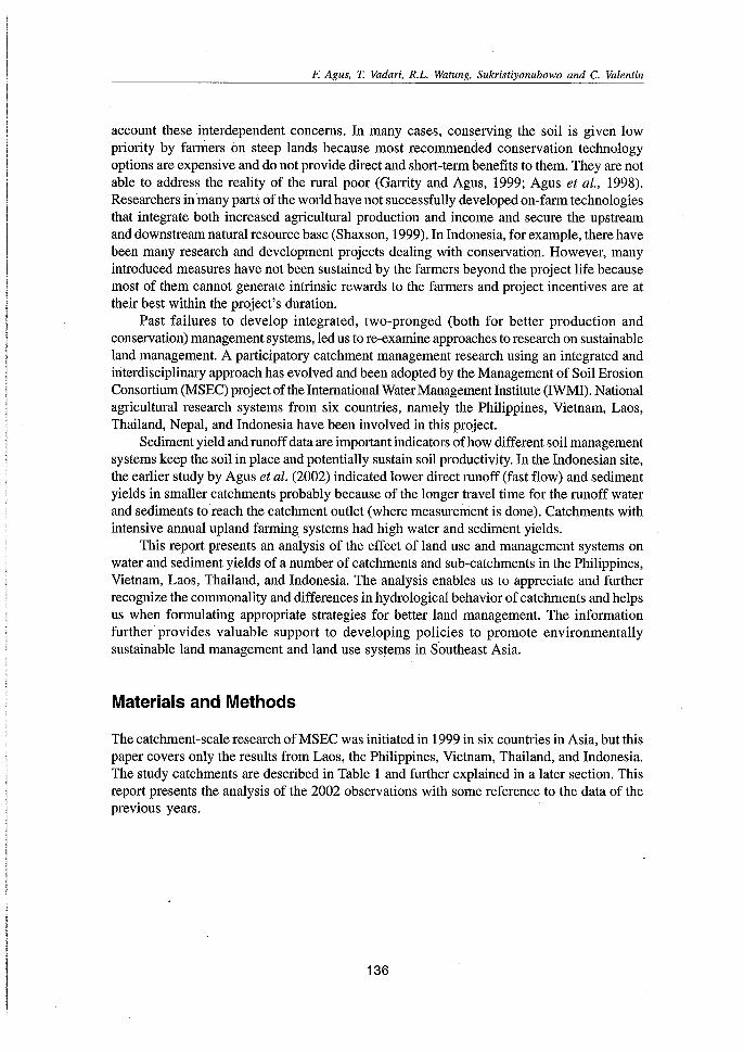
Effects of Land Use and Management Systems onWater and Sediment Yields: Evaluation from Several
Micro Catchments in Southeast Asia
F. Agus, T. Vadari, R.L. Watung, Sukristiyonubowo and C. Valentin
Abstract
In an effort to develop economically promising and environmentally benign catchmentscale upland management systems, the Management of Soil Erosion Consortium (MSEC)initiated intensive soil erosion studies in selected catchments in the Philippines, Thailand,Laos, Vietnam, Nepal, and Indonesia. Hydrological stations were equipped with automaticwater level recorders and staff gauges to measure water and sediment yields from eachcatchment and sub-catchment. Rainfall data were collected using automatic weather stationsand manual rain gauges. Sediment and water yields were analyzed as these relate to landuse and management systems at the micro catchment scale. The analysis showed that landuse and management techniques greatly affect sediment and water yields. Catchments withgood landscape filter systems such as orchards and forest with natural undergrowth, andcatchments with grass strips as hedgerows showed better control of erosion than thoseunder intensive cultivation of annual crops, or perennial trees but no undergrowth cover.Smaller sub-catchments used intensively for annual crops exhibited a shorter lag timebetween the peak of rainfall and the peak of runoff. Moreover, their runoff coefficients wererelatively higher than those of catchments with perennial trees and good undergrowth andlitter cover. This translates to the higher flood mitigation functions of better-coveredcatchments. Erosion from paddy fields is negligible and usually higher during tillageoperation. Better regulation in waterflow between plots can significantly control the sedimentoutflow from terraced paddy fields.
Introduction
Poverty and land degradation exist in a vicious cycle largely affecting the marginalized uplandpoor farmers in Southeast Asia. High population growth, for example 1.6 percent per annum inIndonesia, results in a continued increase in food demand and increased encroachment onthe less suitable steep lands to produce more crops. Contrary to soil conservation principles,these steep lands have been inappropriately managed, unintentionally increasing runoff andaccelerating soil erosion and sedimentation.
Because of the undividable link among the biophysical, socio-economic, and culturalfactors, they should all be considered in developing options for improved soil management.Lack of implementation of research results may have been caused by the failure to take into
I Center for Soil & Agroclimate Research, Jalan, Ir. H. Juanda 98, Bogor 16123, Malaysia.
135
F. Agus, T. Vadari, R.L. Watung, Sukristiyonubowo and C. Valentin
account these interdependent concerns. In many cases, conserving the soil is given lowpriority by farmers on steep lands because most recommended conservation technologyoptions are expensive and do not provide direct and short-term benefits to them. They are notable to address the reality of the rural poor (Garrity and Agus, 1999; Agus et al., 1998).Researchers in many parts of the world have not successfully developed on-farm technologiesthat integrate both increased agricultural production and income and secure the upstreamand downstream natural resource base (Shaxson, 1999). In Indonesia, for example, there havebeen many research and development projects dealing with conservation. However, manyintroduced measures have not been sustained by the farmers beyond the project life becausemost of them cannot generate intrinsic rewards to the farmers and project incentives are attheir best within the project's duration.
Past failures to develop integrated, two-pronged (both for better production andconservation) management systems, led us to re-examine approaches to research on sustainableland management. A participatory catchment management research using an integrated andinterdisciplinary approach has evolved and been adopted by the Management of Soil ErosionConsortium (MSEC) project of the International WaterManagement Institute (IWMI). Nationalagricultural research systems from six countries, namely the Philippines, Vietnam, Laos,Thailand, Nepal, and Indonesia have been involved in this project.
Sediment yield and runoff data are important indicators of how different soil managementsystems keep the soil in place and potentially sustain soil productivity. In the Indonesian site,the earlier study by Agus et al. (2002) indicated lower direct runoff (fast flow) and sedimentyields in smaller catchments probably because of the longer travel time for the runoff waterand sediments to reach the catchment outlet (where measurement is done). Catchments withintensive annual upland farming systems had high water and sediment yields.
This report presents an analysis of the effect of land use and management systems onwater and sediment yields of a number of catchments and sub-catchments in the Philippines,Vietnam, Laos, Thailand, and Indonesia. The analysis enables us to appreciate and furtherrecognize the commonality and differences in hydrological behavior of catchments and helpsus when formulating appropriate strategies for better land management. The informationfurther provides valuable support to developing policies to promote environmentallysustainable land management and land use systems in Southeast Asia.
Materials and Methods
The catchment-scale research of MSEC was initiated in 1999 in six countries in Asia, but thispaper covers only the results from Laos, the Philippines, Vietnam, Thailand, and Indonesia.The study catchments are described in Table 1 and further explained in a later section. Thisreport presents the analysis of the 2002 observations with some reference to the data of theprevious years.
136
F. Agus, T. Vadari, R.L. Watung, Sukristiyonubowo and C. Valentin
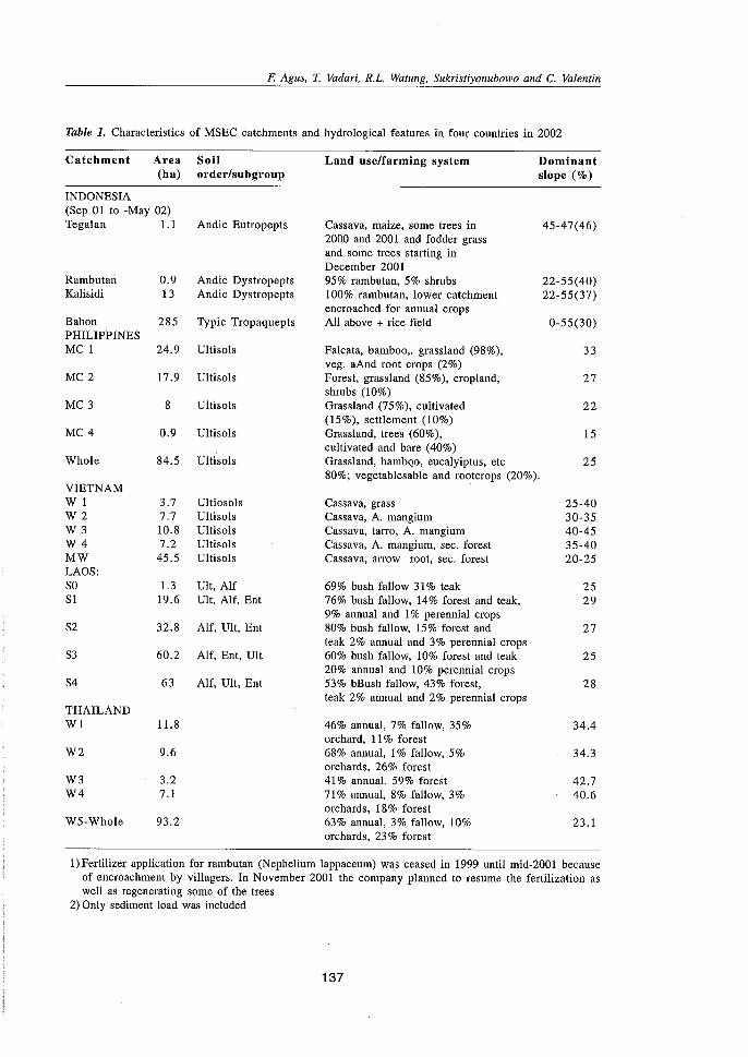
Table 1. Characteristics of MSEC catchments and hydrological features in four countries in 2002
Catchment Area Soil Land use/farming system Dominant(ha) order/subgroup slope (%)
INDONESIA(Sep 01 to -May 02)Tegalan l.l Andic Eutropepts Cassava, maize, some trees in 45-47(46)
2000 and 200 I and fodder grassand some trees starting inDecember 2001
Rambutan 0.9 Andic Dystropepts 95% rambutan, 5% shrubs 22-55(40)Kalisidi 13 Andic Dystropepts 100% rambutan, lower catchment 22-55(37)
encroached for annual cropsBabon 285 Typic Tropaquepts All above + rice field 0-55(30)PHILIPPINESMCI 24.9 Ultisols Falcata, bamboo,. grassland (98%), 33
veg. aAnd root crops (2%)MC2 17.9 Ultisols Forest, grassland (85%), cropland, 27
shrubs (10%)MC3 8 Ultisols Grassland (75%), cultivated 22
(15%), settlement (10%)MC4 0.9 Ultisols Grassland, trees (60%), 15
cultivated and bare (40%)Whole 84.5 Ultisols Grassland, bamboo, eucalyiptus, etc 25
80%; vegetablesable and rootcrops (20%).VIETNAMWl 3.7 Ultiosols Cassava, grass 25-40W2 7.7 Ultisols Cassava, A. mangium 30-35W3 10.8 Ultisols Cassava, tarro, A. mangium 40-45W4 7.2 Ultisols Cassava, A. mangium, sec. forest 35-40MW 45.5 Ultisols Cassava, arrow root, sec. forest 20-25LAOS:SO 1.3 Ult, Alf 69% bush fallow 31% teak 25SI 19.6 Ult, Alf, Ent 76% bush fallow, 14% forest and teak, 29
9% annual and I% perennial cropsS2 32.8 Alf, Ult, Ent 80% bush fallow, 15% forest and 27
teak 2% annual and 3% perennial cropsS3 60.2 Alf, Ent, Ult 60% bush fallow, 10% forest and teak 25
20% annual and 10% perennial cropsS4 63 Alf, Ult, Ent 53% bBush fallow, 43% forest, 28
teak 2% annual and 2% perennial cropsTHAILANDWl 11.8 46% annual, 7% fallow, 35% 34.4
orchard, 11% forestW2 9.6 68% annual, 1% fallow, 5% 34.3
orchards, 26% forestW3 3.2 41% annual, 59% forest 42.7W4 7.1 71% annual, 8% fallow, 3% 40.6
orchards, 18% forestW5-Whole 93.2 63% annual, 3% fallow, 10% 23.1
orchards, 23% forest
I) Fertilizer application for rambutan (Nephelium lappaceum) was ceased in 1999 until mid-2001 becauseof encroachment. by villagers. In November 2001 the company planned to resume the fertilization aswell as regenerating some of the trees
2) Only sediment load was included
137
F. Agus, T. Vadari, R.L. Watung, Sukristiyonubowo and C. Valentin
Hydrological Characterization
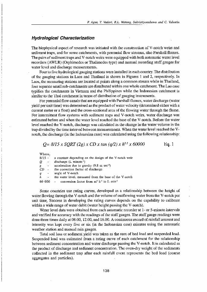
The biophysical aspect of research was initiated with the construction of V-notch weirs andsediment traps, and for some catchments, with perennial flow streams, also Parshall flumes.The pairs of sediment traps and V-notch weirs were equipped with both automatic water levelrecorders (AWLR) (Orphimedes or Thalimedes type) and manual recording staff gauges forwater level and discharge measurements.
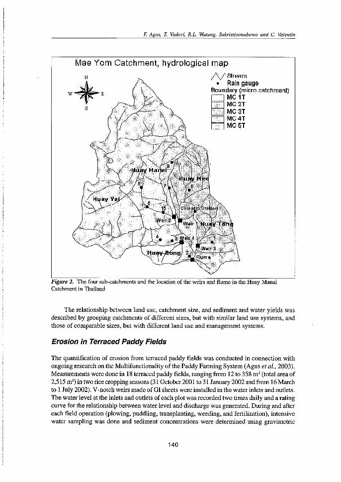
Four to five hydrological gauging stations were installed in each country. The distributionof the gauging stations in Laos and Thailand is shown in Figures 1 and 2, respectively. InLaos, the measuring stations are located at points along a common stream while in Thailand,four separate small sub-catchments are distributed within one whole catchment. The Lao casetypifies the catchments in Vietnam and the Philippines while the Indonesian catchment issimilar to the Thai catchment in terms of distribution of gauging instruments.
For perennial flow canals that are equipped with Parshall flumes, water discharge (wateryield per unit time) was determined as the product of water velocity (determined either with acurrent meter or a float) and the cross-sectional area of the flowing water through the flume.For intermittent flow systems with sediment traps and V-notch weirs, water discharge wasestimated before and when the water level reached the base of the V-notch. Before the waterlevel reached the V-notch, discharge was calculated as the change in the water volume in thetrap divided by the time interval between measurements. When the water level reached the Vnotch, the discharge (in the Indonesian case) was calculated using the following relationship:
Q= 8/15 X SQRT (2g) x CD x tan (q/2) x h2.5 x 60000 Eq.l
Where,8/15 QgCD qh
60 000
a constant depending on the design of the V-notch weirdischarge (L minute")acceleration due to gravity (9.8 m sec')the correction factor of dischargeangle of V-notchthe water level, measured from the base of the V-notch
conversion factor from m' h-l to L min'
Some countries use rating curves, developed as a relationship between the height ofwater flowing through the V-notch and the volume of outflowing water from the V-notch perunit time; Success in developing the rating curves depends on the capability to calibratewithin a wide range of water debit (water height passing the V-notch).
Water level data were obtained from each automatic recorder at 1- or 5-minute intervalsand verified for accuracy with the readings of the staff gauges. The staff gauge readings weredone three times daily at 08.00, 12.00, and 16.00. A continuous record of rainfall amount andintensity was kept every five or six (in the Indonesian case) minutes using the automaticweather station and manual rain gauges.
Total soil loss or sediment yield was taken as the sum of bed load and suspended load.Suspended load was estimated from a rating curve of each catchment for the relationshipbetween sediment concentration and water discharge passing the V-notch. It is calculated asthe product of discharge and sediment concentration. The oven-dry weight of the sedimentscollected in the sediment trap after each rainfall event represents the bed load (coarseaggregates and particles).
138

F. Agus, T. Vadari, R.L. Watung, Sukristiyonubowo and C. Valentin
Digital Elevation Model(5-m mesh)
(Houay Pano watershed, Luang Prabang province)
. 0 100 200 Meters
o W"lershed limits
• Weirs {SOlo 85)
//\\,/ Temporarily rc ach
, R.ingag ss (r1 to r7)
N Pormanantreach
"" Meteorological stationCr.rInu r
s
c::=J 405 - 4400440-4750 475 - 509
509 - 544544- 579
II1II 579- 614_ 614-649_649-683•.683.-718
Altitude (m)
Figure 1. Digital Elevation Model (DEM) of the Houay Pano Catchment in Laos showing thedifferent sub-catchments and the distribution of the weirs, rain gauges, and the meteorological station
139
F. Agus, T. Vadari, R.L. Watung, Sukristiyonubowo and C. Valentin
Mae Yom Catchment, hydrological map
s
/VStream•. Rain gaugE!
Boundary (micro catchment)DMC1TIxhl MC 2TI':!,j,] MC'3T1····••··IMC4TI.IMC5T
Figure 2. The four sub-catchments and the location of the weirs and flume in the Huay ManaiCatchment in Thailand
The relationship between land use, catchment size, and sediment and water yields wasdescribed by grouping catchments of different sizes, but with similar land use systems, andthose of comparable sizes, but with different land use and management systems.
Erosion in Terraced Paddy Fields
The quantification of erosion from terraced paddy fields was conducted in connection withongoing research Onthe Multifunctionality of the Paddy Farming System (Agus et al., 2003).Measurements were done in 18 terraced paddy fields, ranging from 12 to 358 m2 (total area of2,515 m-) in two rice cropping seasons (31 October 2001 to 31 January 2002 and from 16 Marchto 1 July 2002). V-notch weirs made of GI sheets were installed in the water inlets and outlets.The water level at the inlets and outlets of each plot was recorded two times daily and a ratingcurve for the relationship between water level and discharge was generated. During and aftereach field operation (plowing, puddling, transplanting, weeding, and fertilization), intensivewater sampling was done and sediment concentrations were determined using gravimetric
140
F. Agus, T. Vadari, R.L. Watung, Sukristiyonubowo and C. Valentin
procedures. Less frequent (weekly) sampling was done during the rest of the season whensediment concentrations are expected tOil be low. From sediment concentrations and waterdischarge data, the amount of sediment debits entering and leaving the paddy fields wascalculated. .>
Results and Discussion
Catchment Characteristics and an Overview of 2001 Results
The common features of the sloping upland agricultural land areas in the collaborating countriesare the predominantly steep slopes and the poverty of the people. Land use intensity variesfrom a transition from shifting cultivation to a more permanent agriculture in Laos, to a veryintensive farming system in Java, Indonesia. Rainfall patterns, land management systems,and catchment sizes vary within and among countries (Table 1).
The catchments and sub-catchments that were studied intensively varied from 0.9 ha inIndonesia and Philippines to 63 ha in Laos (Figure 3). In Indonesia, the Tegalan, Rambutan,and Kalisidi sub-catchments have intermittent flow and discharge in the drainage canals canonly be observed during and shortly after heavy rainfall events. Discharge in Kalisidi isintermittent but continues to flow for a longer time after each heavy rainfall event, and is stillobserved for several consecutive days during the peak of the rainy season. Lao and Vietnamesecatchments have perennial flow while those in Thailand and the Philippines have intermittentstreams.
300
o
50 JI I I
~ 150'(j)-C(I)
EJ:
~o
ca 200J:-
250
1-0: ~ =-:t !=.2~ =~.... (\J(') "g<c .... (\J(') -:t= .... (\J (') -:tz
E:E: E: « .- s: .c 0 0 0 .c s: s: .c« ZZ z z>c:: s: .c ._ m m m m 0 I- 1-1- I-.c » > >-11. 11.11. ll..c ...J ...J...J ...J m l-ll. ...J
Country
Figure 3. Size of the MSEC catchments in Indonesia (In), the Philippines (Phi), Laos (Lao), Thailand(Th), and Vietnam (VN). T, R, and K for Indonesia stand for Tegalan, Rambutan, and Kalisidi, andmodifier 'All' means the overall catchment encasing all sub-catchments
141
F. Agus, T. Vadari, R.L. Watung, Sukristiyonubowo and C. Valentin
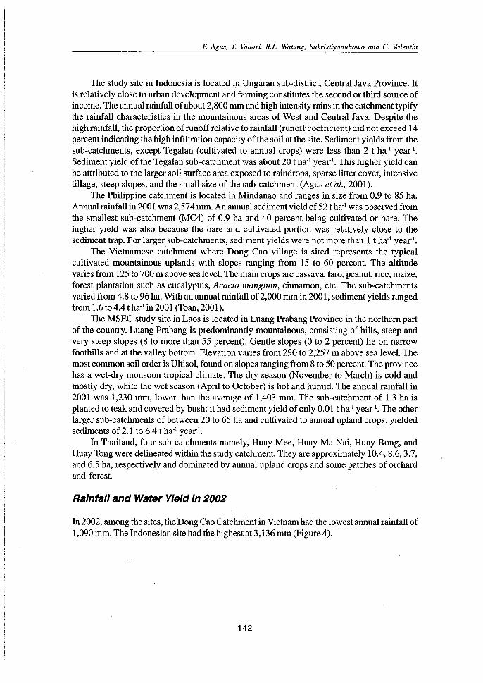
The study site in Indonesia is located in Ungaran sub-district, Central Java Province. Itis relativelyclose to urban development and farming constitutes the second or third source ofincome. The annual rainfall of about 2,800 mm and high intensity rains in the catchment typifythe rainfall characteristics in the mountainous areas of West and Central Java. Despite thehigh rainfall, the proportion of runoff relative to rainfall (runoff coefficient) did not exceed 14percent indicating the high infiltration capacity of the soil at the site. Sediment yields from thesub-catchments, except Tegalan (cultivated to annual crops) were less than 2 t ha'! year".Sediment yield of the Tegalan sub-catchment was about 20 t ha' year:'. This higher yield canbe attributed to the larger soil surface area exposed to raindrops, sparse litter cover, intensivetillage, steep slopes, and the small size of the sub-catchment (Agus et ai; 2001) ..
The Philippine catchment is located in Mindanao and ranges in size from 0.9 to 85 ha.Annual rainfall in 2001 was 2,574 mm. An annual sediment yield of 52 t ha'! was observed fromthe smallest sub-catchment (MC4) of 0.9 ha and 40 percent being cultivated or bare. Thehigher yield was also because the bare and cultivated portion was relatively close to thesediment trap. For larger sub-catchments, sediment yields were not more than 1 t ha'! year".
The Vietnamese catchment where Dong Cao village is sited represents the typicalcultivated mountainous uplands with slopes ranging from 15 to 60 percent. The altitudevaries from 125 to 700 m above sea level. The main crops are cassava, taro, peanut, rice, maize,forest plantation such as eucalyptus, Acacia mangium, cinnamon, etc. The sub-catchmentsvaried from 4.8 to 96 ha. With an annual rainfall of 2,000 mm in 2001, sediment yields rangedfrom 1.6 to 4Atha,qn 2001 (Toan, 2001).
The MSEC study site in Laos is located in Luang Prabang Province in the northern partof the country. Luang Prabang is predominantly mountainous, consisting of hills, steep andvery steep slopes (8 to more than 55 percent). Gentle slopes (0 to 2 percent) lie on narrowfoothills and at the valley bottom. Elevation varies from 290 to 2,257 m above sea level. Themost common soil order is Ultisol, found on slopes ranging from 8 to 50 percent. The provincehas a wet-dry monsoon tropical climate. The dry season (November to March) is cold andmostly dry, while the wet season (April to October) is hot and humid. The annual rainfall in2001 was 1,230 mm, lower than the average of 1,403 mm. The sub-catchment of 1.3 ha isplanted to teak and covered by bush; it had sediment yield of only 0.01 t ha,l year:'. The otherlarger sub-catchments of between 20 to 65 ha and cultivated to annual upland crops, yieldedsediments of 2.1 to 604 t ha'! year",
In Thailand, four sub-catchments namely, Huay Mee, Huay Ma Nai, Huay Bong, andHuay Tong were delineated within the study catchment. They are approximately 1004,8.6,3.7,and 6.5 ha, respectively and dominated by annual upland crops and some patches of orchardand forest.
Rainfall and Water Yield in 2002
In 2002, among the sites, the Dong Cao Catchment in Vietnam had the lowest annual rainfall of1,090 mm. The Indonesian site had the highest at 3,136 mm (Figure 4).
142
F. Agus, T. Vadari, R.L. Watung, Sukristiyonubowo and C. Valentin
35003136
3000 -
-§ 25002103-ca 2000- 1651e
'iij.. 1500ca 1129 1090::Je
1000
I-r le«
500
o - --·--1-----,---- -,----
Ind Phi Lao Tha VNCountry
Figure 4. Annual rainfall (mm) at the different MSEC catchments in 2002
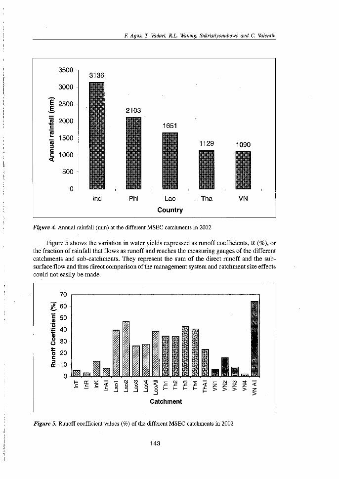
Figure 5 shows the variation in water yields expressed as runoff coefficients, R (%), orthe fraction of rainfall that flows as runoff and reaches the measuring gauges of the differentcatchments and sub-catchments. They represent the sum of the direct runoff and the subsurface flow and thus direct comparison of the management system and catchment size effectscould not easily be made.
70 -.-------------------------,
?f. 60-C 50Cl)
'ulE 40~o 30·
~ 20c::Ja: 10
o -I- a:: ~ « g C\I C') '<;f'
~ E C\I C') '<;f' « Z C\I C') '<;f' «.s .s .s 2 2 0 .c: s: .c: Z Z z.s III 0 I- I- I- I- .c: > > > >...J ...J ...J ...J III I- Z...J >
Catchment
Figure 5, Runoff coefficient values (%) of the different MSEC catchments in 2002
143
F. Agus, T. Vadari, RL Watung, Sukristiyonubowo and C. Valentin
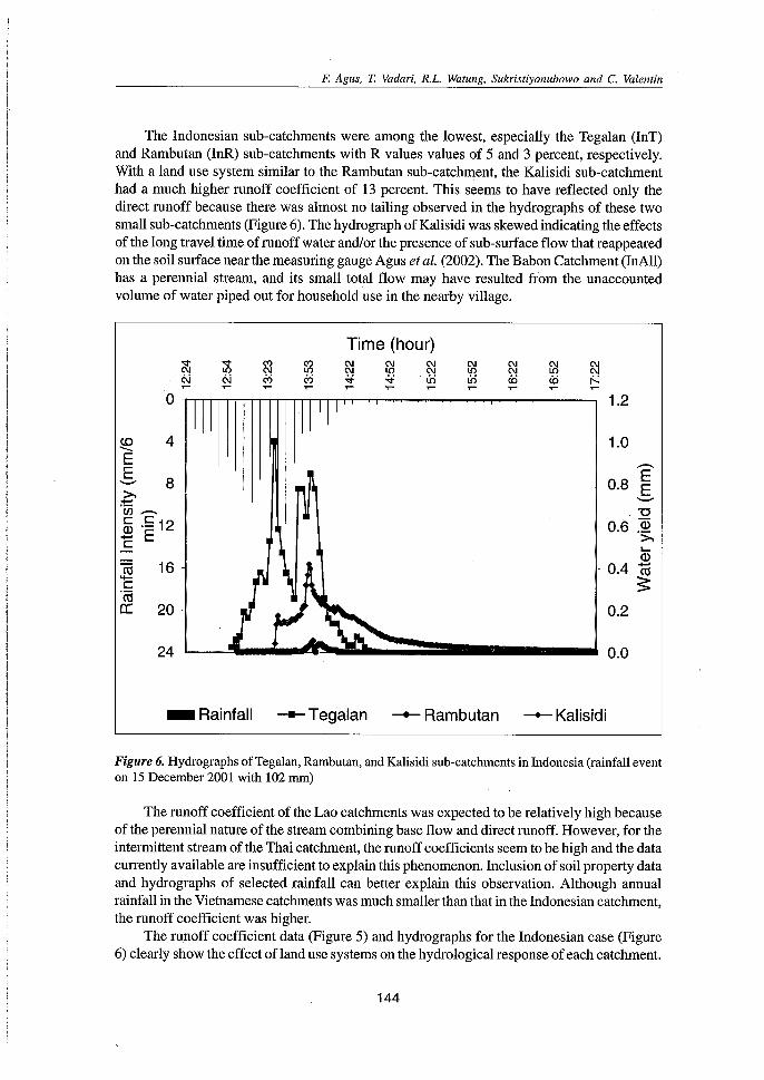
The Indonesian sub-catchments were among the lowest, especially the Tegalan (InT)and Rambutan (InR) sub-catchments with R values values of 5 and 3 percent, respectively.With a land use system similar to the Rambutan sub-catchment, the Kalisidi sub-catchmenthad a much higher runoff coefficient of 13 percent. This seems to have reflected only thedirect runoff because there was almost no tailing observed in the hydrographs of these twosmall sub-catchments (Figure 6). The hydrograph of Kalisidi was skewed indicating the effectsof the long travel time of runoff water and/or the presence of sub-surface flow that reappearedon the soil surface near the measuring gauge Agus et al. (2002). The Babon Catchment (InAll)has a perennial stream, and its small total flow may have resulted from the unaccountedvolume of water piped out for household use in the nearby village.
Time (hour)
"'" "'" C') C') C\J C\J C\J C\J C\JC\J io C\J io C\J io C\J io C\JN N c'j c'j -<i -<i Ui Ui cD.... .... .... .... .... .... .... .... ....
«S 16-.....c.~
er: 20-
1.2
1.0
E- 0.8 E"-"
. "0- 0.6 ID
';;'....ID
- 0.4 ~
0.2
24 _L-!I("~..d~~";::==== -'. 0.0
_Rainfall -Tegalan -Rambutan -Kalisidi
Figure 6. Hydrographs of Tegalan, Rambutan, and Kalisidi sub-catchments in Indonesia (rainfall eventon 15 December 2001 with 102 mm)
The runoff coefficient of the Lao catchments was expected to be relatively high becauseof the perennial nature of the stream combining base flow and direct runoff. However, for theintermittent stream of the Thai catchment, the runoff coefficients seem to be high and the datacurrently available are insufficient to explain this phenomenon. Inclusion of soil property dataand hydrographs of selected rainfall can better explain this observation. Although annualrainfall in the Vietnamese catchments was much smaller than that in the Indonesian catchment,the runoff coefficient was higher.
The runoff coefficient data (Figure 5) and hydrographs for the Indonesian case (Figure6) clearly show the effect of land use systems on the hydrological response of each catchment.
144
F. Agus, T. Yadari, R.L. Watung, Sukristiyonubowo and C. Valentin
The Tegalan Catchment planted to intensive annual crops had a higher R value and was moreresponsive (transmitting rainfall into runoff more readily) to rainfall than the Rambutan andKalisidi sub-catchments with perennial tree cover. There was a shorter lag time between thepeak of rainfall and the peak of discharge in the Tegalan Catchment than in the other two subcatchments. Runoff also stopped earlier after the rain. The Rambutan sub-catchment wasvery nicely covered, not only by rambutan trees, but also by natural vegetation and a treelitter layer on the floor. Near its outlet, an area of about 5 percent of the sub-catchment wasbush fallow. These conditions have resulted in high infiltration and low runoff even with ahigh amount (102 mm) and intensity of rainfall during this particular event.
Sediment Yield and Land Use
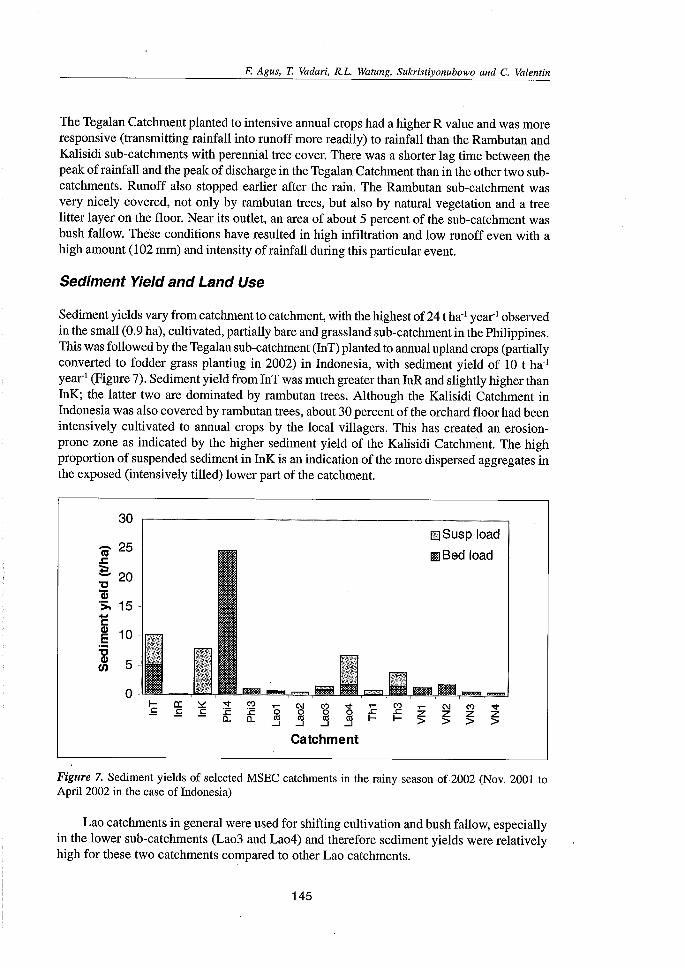
Sediment yields vary from catchment to catchment, with the highest of 24 t ha' year! observedin the small (0.9 ha), cultivated, partially bare and grassland sub-catchment in the Philippines.This was followed by the Tegalan sub-catchment (InT) planted to annual upland crops (partiallyconverted to fodder grass planting in 2002) in Indonesia, with sediment yield of 10 t ha'year:' (Figure 7). Sediment yield from InT was much greater than InR and slightly higher thanInK; the latter two are dominated by rambutan trees. Although the Kalisidi Catchment inIndonesia was also covered by rambutan trees, about 30 percent of the orchard floor had beenintensively cultivated to annual crops by the local villagers. This has created an erosionprone zone as indicated by the higher sediment yield of the Kalisidi Catchment. The highproportion of suspended sediment in InK is an indication of the more dispersed aggregates inthe exposed (intensively tilled) lower part of the catchment.
30 -
- 25 -1tI.c~ 20"0"ij)'>' 15-l:~ 10:g(J) 5-
0-
~ ~ ~Catchment
..s:I-
C').cI-
..-z>
ffiillSusP load
ImBed load
.......C')
z>
Figure 7. Sediment yields of selected MSEC catchments in the rainy season of2002 (Nov. 2001 toApril 2002 in the case of Indonesia)
Lao catchments in general were used for shifting cultivation and bush fallow, especiallyin the lower sub-catchments (Lao3 and Lao4) and therefore sediment yields were relativelyhigh for these two catchments compared to other Lao catchments.
145
F. Agus, T. Vadari, R.L. Watung, Sukristiyonubowo and C. Valentin
In general, intensively cultivated catchments were observed to have higher sedimentyields than other land uses. However, more specific and localized conditions, such as those inthe Kalisidi sub-catchment in Indonesia, determine to a large extent the land susceptibility toerosion and this fact reemphasizes the importance of integrating the human dimension informulating policies for natural resource management. As in the case of La04 and InK subcatchments, equal attention should be given to the more open/exposed areas near the catchmentoutlet which greatly affect the total sediment yield. In developing soil conservationrecommendations, this area near the catchment outlet (and this translates to the zone alongthe stream) should be paid more attention.
The Special Case of Indonesian Land Management Systems
Grass strips for annual upland crop-based catchment vs. cultivation at the floorof the orchard
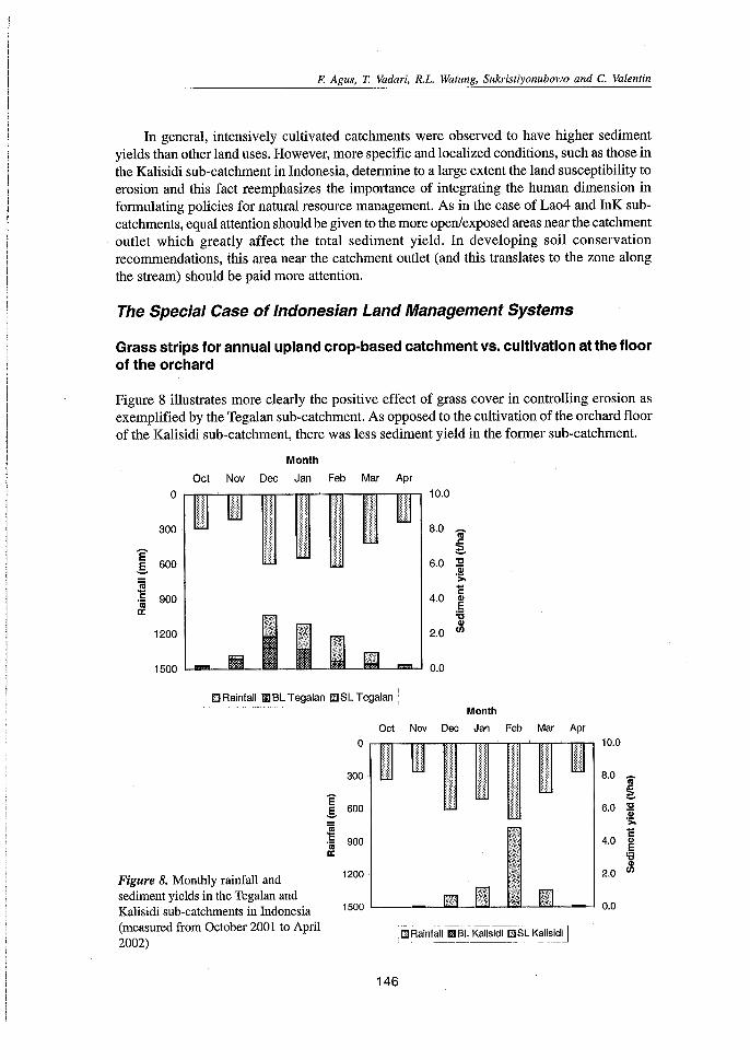
Figure 8 illustrates more clearly the positive effect of grass cover in controlling erosion asexemplified by the Tegalan sub-catchment. As opposed to the cultivation of the orchard floorof the Kalisidi sub-catchment, there was less sediment yield in the former sub-catchment.
Month
Oct Nov Dec Jan Feb Mar Apr
0
300
E600.§.
~ 900'0;a:
1200
1500
:::i::! iiHi I1i111ilum,i
mil1~i: ~: i:i ~;i:~:i
10.0
8.0 ca~
6.0 il's;.1:
4.0 ~
'6~2.0
Il.lJRainfalll!lllBL Tegalan E!J~L Tegalan !Month
oct Nov Dec Jan Feb
1500 '-------''''''''--'
Mar Apr
1111111
10.0:~::;:
:m~~8.0 ca
::::;::~
6.0 'C]!>-C
4.0 Q)
E'6Q)
2.0 (fl
0.0
1200
~'0; 900a:
E.§. 600
Figure 8. Monthly rainfall andsediment yields in the Tegalan andKalisidi sub-catchments in Indonesia(measured from October 2001 to April2002)
146
F. Agus, T. Vadari, R.L. Watung, Sukristiyonubowo and C. Valentin
In December 2001, there was 600 mm of rainfall in the area, about 450 mm in January 2002and 620 mm in February 2002. It was observed that the corresponding monthly water dischargefrom the sub-catchments followed the same pattern as the rainfall, also increasing fromDecember 2001 to February 2002. Monthly sediment yields, however, did not follow the wateryield pattern but showed the influence of the management systems. The planting of foddergrass in December 2001 (as part of the introduced option) combined with zero tillage in theTegalan sub-catchment improved the catchment filter function with time as shown by thedecrease in sediment yields in the succeeding months. For the Kalisidi sub-catchment, themonthly sediment yields followed those of the water yield pattern. These results confirm theeffectiveness of the grass system in improving the filter function of the catchment. Theplanting of grass hedgerows in combination with cattle fattening, not only decreased erosion,but also promises higher profits. Hence, the system became the most preferred practice by thefarmers (Watung et al., 2003).
Soil Loss from Terraced Paddy Fields
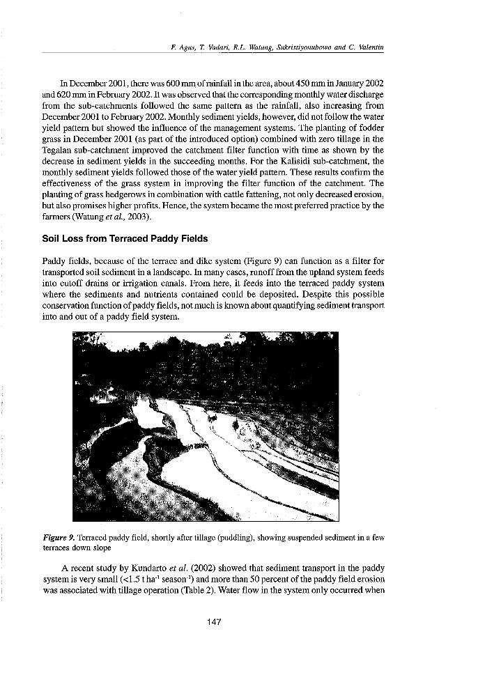
Paddy fields, because of the terrace and dike system (Figure 9) can function as a filter fortransported soil sediment in a landscape. In many cases, runoff from the upland system feedsinto cutoff drains or irrigation canals. From here, it feeds into the terraced paddy systemwhere the sediments and nutrients contained could be deposited. Despite this possibleconservation function of paddy fields, not much is known about quantifying sediment transportinto and out of a paddy field system.
Figure 9. Terraced paddy field, shortly after tillage (puddling), showing suspended sediment in a fewterraces down slope
A recent study by Kundarto et al. (2002) showed that sediment transport in the paddysystem is very small «1.5 t ha'! season:') and more than 50 percent of the paddy field erosionwas associated with tillage operation (Table 2). Water flow in the system only occurred when
147
F. Agus, T. Yadari, R.L. Watung, Sukristiyonubowo and C. Valentin
the water level in the fields exceeded the normal water level (5-10 cm) during tillage and thevegetative stage of the rice plant. Thus, regulating and keeping the water from flowing to thelower terraces can further minimize sediment transport especially during tillage.
Table2. Amount of sediment entering and leaving a series of 18 terraced paddy fields (size between 12to 358 m2 and total area of2,5l5 m2) during two rice cropping seasons (31 October 2001 to 31 January2002 and from 16 March to 1 July 2002).
Variable Cropping sSeason
First Second
Duration of observation (day)
Sediment budget:
Total sediment entering the system from irrigation canal (t /ha-I)Total sediment leaving the system (t /ha-I)Total sediment leaving the system during tillage operation (t /ha-I)Net sediment deposition (t /ha-I)
62
3.4 1)1.40.72
69
6.21)0.80.65.4
Source: Adapted from Kundarto et al. (2002)1) These values may have been overestimated because of the difficulty in controlling the water level in theerosion canal and that in the first terrace.
During and a few hours after tillage, mud from tilled terraces was transported to only afew terraces downslope. This means that particles reaching the stream originated from only afew plots/fields nearby. The general slope of this terraced paddy field is about 25 percent, butthe level bench terraces and dike system could haveminimized its effect on erosion. Table 2also shows that if the irrigation water is loaded with sediments, most of these sedimentswould be deposited in the field, implying the filtering ability of the paddy fields to erosion ina landscape.
Conclusions and Recommendations
Catchments with good filter systems such as orchards and forest with naturalundergrowth or catchments planted to grass showed better control of erosion ascompared to catchments used for intensive annual crops or perennial trees, but withcleared undergrowth. Tree cover per se without floor contact-cover such as litterand undergrowth cannot guarantee good erosion control.Mitigating sedimentation is very much influenced by the location of the erosioncontrol measures which serve as filters. The zone along the stream is critical andneeds to be covered with a good filter for stream protection. Conservationrecommendations should emphasize the improvement of vegetative filters along thestreams.
• Erosion from paddy fields is negligible compared to that from annual upland farmingsystems of similar general slope, and paddy fields can function as sediment filters ina landscape.
148
F. Agus, T. Vadari, R.L. Watung, Sukristiyonubowo and C. Valentin
Acknowledgement
This research was funded by the Asian Development Bank (ADB) under RETA 5803.
References
Agus, F.;Vadari,T.; Sukristiyonubowo; Hermiyanto, B.; Bricquet, J.P.; and Maglinao, A. 2002.Catchment size and land management systems affect water and sediment yields. InProceedings, 12lh ISCO conference. Bejing, China. pp. 469-475.
Agus, F.; Sukristiyonubowo; Vadari, T.; Hermiyanto, R; Watung, RL.; and Setiani, C. 2001.Managing soil erosion in Kaligarang catchment of Java, Indonesia. MSEC-IndonesiaCountry Report, MSEC Assembly, Hanoi 10-14 Dec. 200t
Agus, F; Watung, RL.; Suganda, H.; Talaohu, S.H., Wahyunto; Sutono, S.; Setiyanto, A;Mayrowani, H.; Nurmanaf, R; and Kundarto M. 2003. Assessment of environmentalmultifunctions of rice paddy farming in Citarum River Basin, West Java, Indonesia. Paperpresented at the 3rd Working Group Meeting of the ASEAN-JAPAN Project onMultifunctionality of Paddy Farming and Its Effects in ASEAN Member Countries, PhnomPenh, Cambodia, 27 February to 1 March 2003.
Boonsaner, A; Jirasuktaveekul, W.; Adirektrakarn, W.; Janeau, J.L.; and Bricquet, J.P. 2001.Catchment approach to combating soil erosion in Thailand. MSEC Thailand CountryReport. MSEC Assembly, Hanoi 10-14 Dec. 2001.
Duque, C.M., Snr.; Tiongco, L.E.; Quita, RS.; Carpina, N.Y.; Santos, B.; Ilao, RO.; and deGuzman, T. 2001. Management of soil erosion consortium: An innovative approach tosustainable land management in the Philippines. MSEC-Philippines Annual Report.IWMISEA, Bangkok.
Garrity, D.P.; and Agus, F. 1999. Natural resource management on a watershed scale: What canagroforestry contribute? In Lal, R. (ed.), Integrated watershed management in the globalecosystem, CRC Press, Washington, D.C. pp. 165-193.
Kundarto, M.; Agus, F.;Maas, A; and Sunarminto, RH. 2002. Water balance, soil erosion andlateral transport of NPK in rice-fields system of sub watershed Kalibabon Semarang.Paper presented in the seminar "Multifunctionality of Paddy Field" 2 October 2002,Bogor. (In Indonesian)
MSEC-Lao PDR. 2001. An innovative approach to sustainable land management in Lao. MSECLao PDR Annual Report. IWMI SEA, Bangkok.
Toan, T.D.; Phien, T.; Phai, D.D.; and Nguyen, L. 2001. Soil erosion and farm productivityunder different land uses. MSEC- Vietnam Annual Report. IWMI SEA, Bangkok.
Watung, RL.; Vadari, T.; Sukristiyonubowo; Subiharta; and Agus, F. 2003. Managing soilerosion in Kaligarang catchment of Java, Indonesia. Phase 1 Project Completion Report,Management of Soil Erosion Consortium. IWMI, Southeast Asia, Bangkok.
149
From Soil Research to Land and-Water Management:Harmonizing People and Nature
IWMI-ADB Project Annual Meeting and Jlh MSEC Assembly
Amado R. Maglinao, Christian Valentin and Frits Penning deVries, editors
Internationalt r Management
Institute
From Soil Research '~O Land and Water Management:Harmonizing People and Nature
Proceedings of the IWMI-ADB Project Annual Meetingand 7th MSEC Assembly
.Organized byNational Agriculture and Forestry Research Institute (NAFRI)
Vientiane, Lao PDRInstitute of Research for Development (IRD)
Vientiane, Lao PDRInternational Water Management Institute (IWMI)
Southeast Asia Regional Office (IWMI-SEA)Bangkok, Thailand
With support fromThe Asian Development Bank (ADB)
Manila, Philippines
Held at Vientiane, Lao PDR2-7 December 2002
Amado R. MaglinaoChristian Valentin and
Frits Penning de Vries, editors
International Water Management Institute (IWMI)Southeast Asia Regional Office
7th Floor, Institute of Food Research and Product Development (IFRPD)Kasetsart University, Jatujak, Bangkok 10903,THAILAND
December 2003
IWMI receives its principal funding from 58 governments, private foundations, and internationaland regional organizations known as the Consultative Group on International AgriculturalResearch (CGIAR)
The editors: Amado R Maglinao is a Senior Researcher and Frits Penning de Vries is theTheme 2 Leader of the International Water Management Institute, Southeast Asia RegionalOffice, Bangkok, Thailand and South Africa Regional Office, Pretoria, South Africa,respectively. Christian Valentin is a Principal Scientist seconded to IWMI from the Institute ofResearch for Development in Vientiane, Lao PDR
IWMI gratefully acknowledges the financial support from the Asian Development Bank(ADB) for the project
Maglinao, A. R; Valentin, c.; Penning de Vries, F.; (Eds). 2003. From soil research to landand water management: Harmonizing people and nature. Proceedings of the IWMI-ADBProject Annual Meeting and 7th Management of Soil Erosion Consortium (MSEC)Assembly, held at Vientiane, Lao PDR, 2-7 December 2002. Bangkok, Thailand: InternationalWater Management Institute. 250 p.
watershed management / soil management / land management / natural resources / soilconservation / erosion / development projects / rain / agricultural research / watermanagement / tillage / hydrology / rainfall-runoff relationships / catchment areas /statistical analysis / Asia / South East Asia / Indonesia / Laos / Nepal/Philippines /Thailand / Vietnam
ISBN - 929090533 6
Copyright © 2003, by IWMI. All rights reserved
Responsibility for the contents of this publication rests with the authors
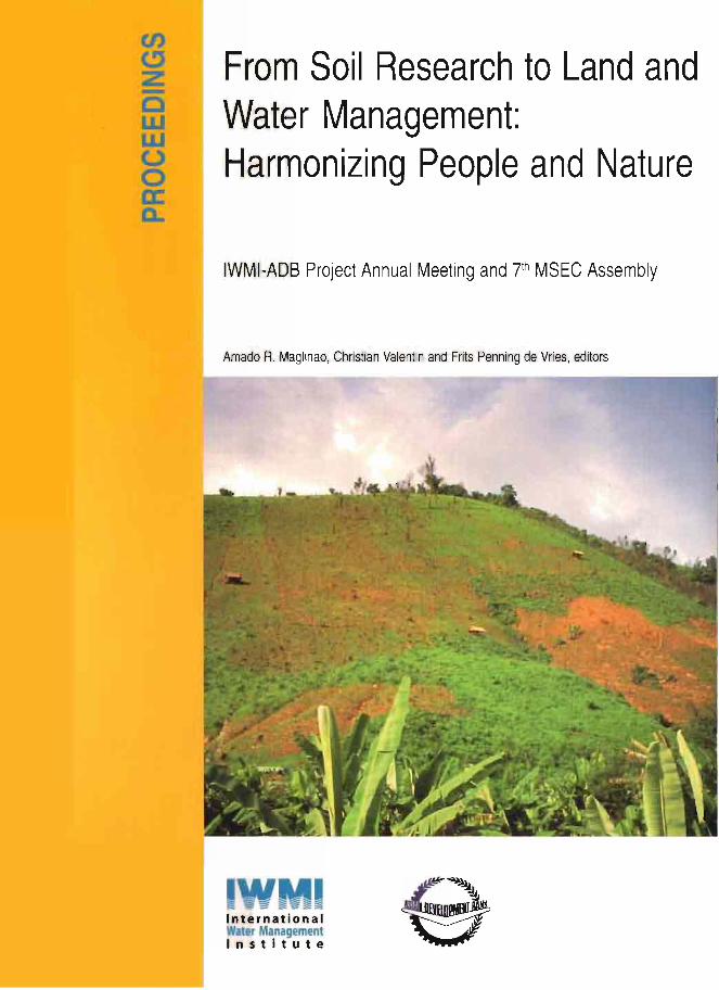
Cover Photograph: Gullies formed on cultivated steep slopes, Houay Pano catchment,Lao PDR, photo. A. de Rouw.
ii