Embed Size (px)
Citation preview
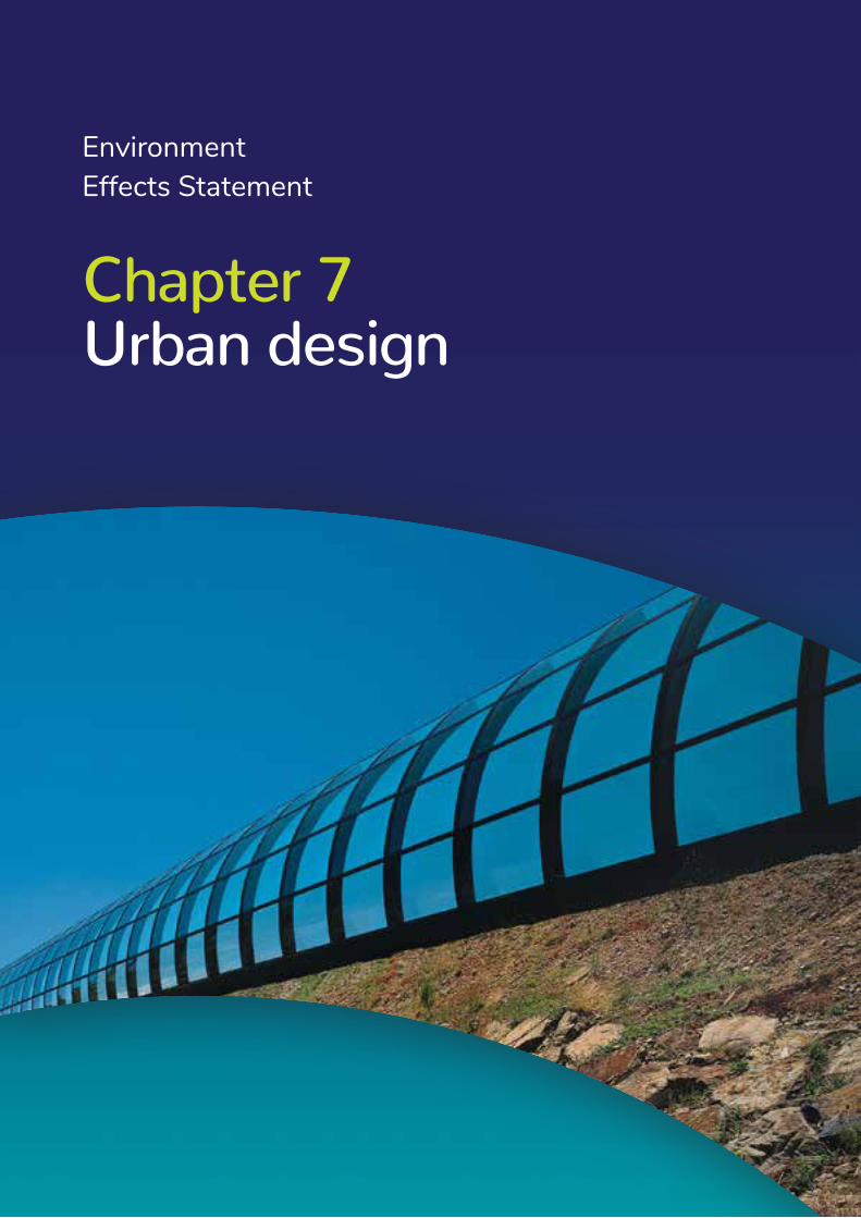
Environment Effects Statement
Chapter 7 Urban design
7 - URBAN
DESIGN
Chapter 7 – Urban design approach | 7–1
Chapter 7 Chapter 7Urban design approach
7.1 Introduction This chapter provides an overview of the approach that has been adopted to ensure urban design excellence for North East Link.
Good urban design creates integrated, functional, attractive, safe, environmentally sustainable and socially equitable places. Given the scale and extent of the infrastructure required for North East Link and the diverse land use setting, the urban design for the project must address a wide range of social, functional, environmental and physical challenges.
An integrated solution is needed to move beyond a business as usual and engineering centred approach to deliver an architecturally significant design that recognises the connection between people, places and the natural environment, and maximises environmental, social and economic outcomes.
Achieving excellence in urban design is a long-term, multidisciplinary and collaborative process. It takes the integration of transport, planning, architecture, landscape architecture, sustainability, heritage, engineering and financial disciplines. The input of Victorian Government and local government stakeholders is needed and community input is important. This is particularly vital to ensure that designs respond to the landscape context, functional requirements and the needs and desires of local communities.
The North East Link Project (NELP) is committed to achieving high quality, integrated design outcomes that contribute positively to the public realm and provide a legacy for local communities in the north-east. An Urban Design Strategy has been developed for North East Link and is provided in EES Attachment II.
The Urban Design Strategy would guide design solutions through the planning, procurement, detailed design and delivery of North East Link. The Urban Design Strategy sets principles, objectives and site-specific requirements so tenderers submit high quality, integrated design solutions. Assessment of urban design would be a key aspect of tender evaluation.
Environment Effects Statement
7–2 | Chapter 7 – Urban design approach
In accordance with Environmental Performance Requirement (EPR) LV1, North East Link would need to be designed to be generally in accordance with the Urban Design Strategy. Ultimately the selected contractor would develop Urban Design and Landscape Plans (UDLPs) that demonstrate conformance with the Urban Design Strategy, for the approval of the Minister for Planning.
Further information on the Urban Design Strategy and its development is provided in the sections below.
7.2 Stakeholder consultation
7.2.1 Consultation undertaken for the development of the Urban Design Strategy
Extensive stakeholder consultation was undertaken for the development of the Urban Design Strategy. Key community and stakeholder groups were consulted about different aspects of the urban design through a number of different forums. Participants included representatives from the Cities of Banyule, Boroondara, Manningham, Whitehorse and Yarra and the Nillumbik Shire Council, the Department of Environment Land Water and Planning (DELWP), Melbourne Water, Parks Victoria, Wurundjeri Woi-wurrung Cultural Heritage Aboriginal Corporation (WWCHAC), the Office of the Victorian Government Architect (OVGA), VicRoads, the Victorian Planning Authority (VPA), Transport for Victoria and Public Transport Victoria (PTV).
Engagement with WWCHAC is planned to be ongoing throughout the life of the project. This has included workshops and Walks on Country to document tangible and intangible cultural values. The findings of these activities have been incorporated throughout the Urban Design Strategy, particularly Key Direction 3: ‘Recognise past, contemporary and shared indigenous and historic cultural values'.
Residents, business owners and other community members were also consulted through small group forums and community drop in sessions. These sessions have included displays of urban design information for discussion and feedback.
7.2.2 Urban Design Advisory Panel
To facilitate a consultative and integrated design approach, the UDAP was formed. The purpose of the UDAP is to provide ongoing expert design guidance and advice, and to advocate for high quality design outcomes for North East Link. UDAP is chaired by NELP with members representing the OVGA, VicRoads, Transport for Victoria and NELP. Other key stakeholders such as local councils and public authorities are represented at location-based workshops and meetings on specific issues to provide input and feedback.
Chapter 7 – Urban design approach | 7–3
The UDAP was established during the project planning phase and its members informed the preparation and development of the Urban Design Strategy. Their role will continue in future project phases, including the tender evaluation process and in providing advice to the Minister on whether the UDLPs comply with the Urban Design Strategy, informing the approval of North East Link’s final built form.
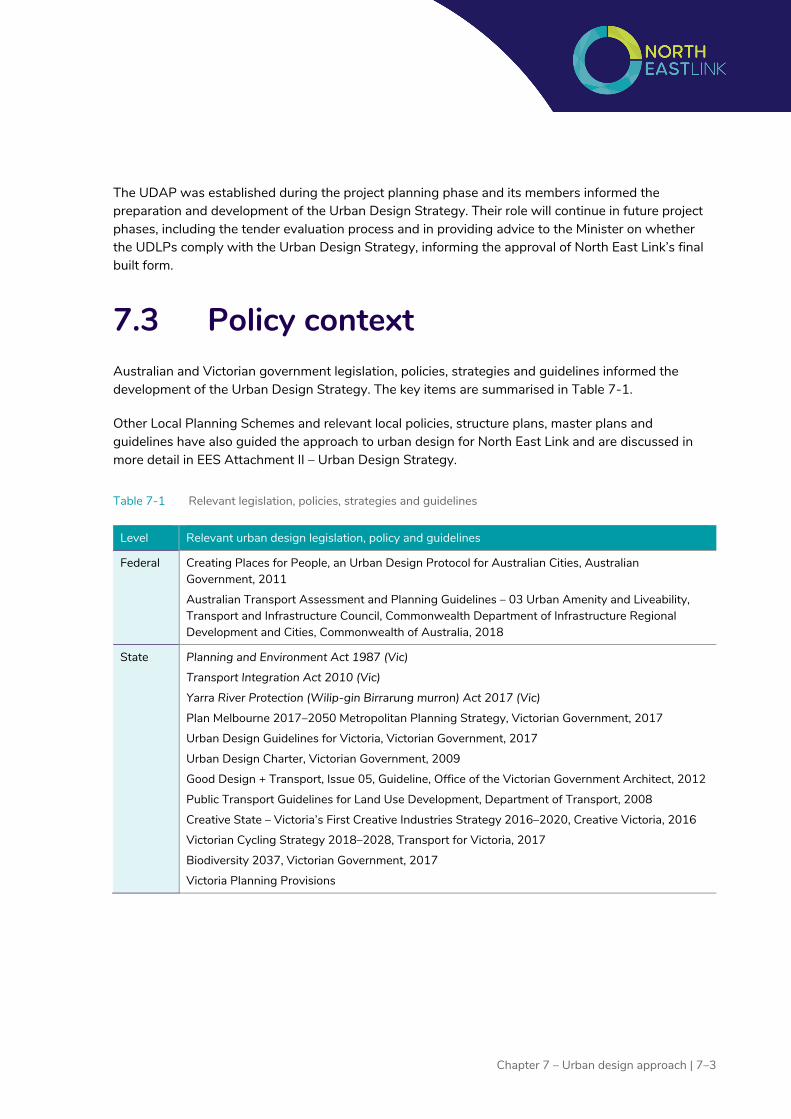
7.3 Policy context Australian and Victorian government legislation, policies, strategies and guidelines informed the development of the Urban Design Strategy. The key items are summarised in Table 7-1.
Other Local Planning Schemes and relevant local policies, structure plans, master plans and guidelines have also guided the approach to urban design for North East Link and are discussed in more detail in EES Attachment II – Urban Design Strategy.
Table 7-1 Relevant legislation, policies, strategies and guidelines
Level Relevant urban design legislation, policy and guidelines
Federal Creating Places for People, an Urban Design Protocol for Australian Cities, Australian Government, 2011 Australian Transport Assessment and Planning Guidelines – 03 Urban Amenity and Liveability, Transport and Infrastructure Council, Commonwealth Department of Infrastructure Regional Development and Cities, Commonwealth of Australia, 2018
State Planning and Environment Act 1987 (Vic) Transport Integration Act 2010 (Vic) Yarra River Protection (Wilip-gin Birrarung murron) Act 2017 (Vic) Plan Melbourne 2017–2050 Metropolitan Planning Strategy, Victorian Government, 2017 Urban Design Guidelines for Victoria, Victorian Government, 2017
Urban Design Charter, Victorian Government, 2009 Good Design + Transport, Issue 05, Guideline, Office of the Victorian Government Architect, 2012
Public Transport Guidelines for Land Use Development, Department of Transport, 2008
Creative State – Victoria’s First Creative Industries Strategy 2016–2020, Creative Victoria, 2016 Victorian Cycling Strategy 2018–2028, Transport for Victoria, 2017
Biodiversity 2037, Victorian Government, 2017 Victoria Planning Provisions
Environment Effects Statement
7–4 | Chapter 7 – Urban design approach
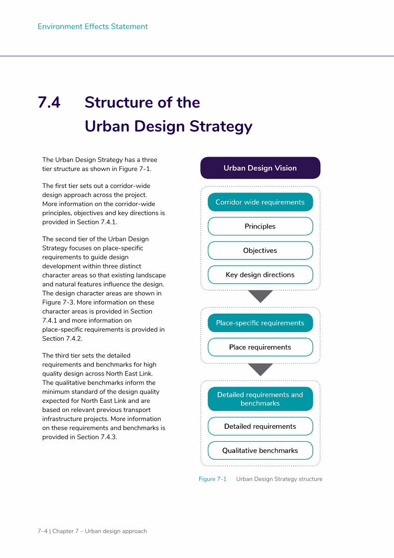
7.4 Structure of the Urban Design Strategy
The Urban Design Strategy has a three tier structure as shown in Figure 7-1.
The first tier sets out a corridor-wide design approach across the project. More information on the corridor-wide principles, objectives and key directions is provided in Section 7.4.1.
The second tier of the Urban Design Strategy focuses on place-specific requirements to guide design development within three distinct character areas so that existing landscape and natural features influence the design. The design character areas are shown in Figure 7-3. More information on these character areas is provided in Section 7.4.1 and more information on place-specific requirements is provided in Section 7.4.2.
The third tier sets the detailed requirements and benchmarks for high quality design across North East Link. The qualitative benchmarks inform the minimum standard of the design quality expected for North East Link and are based on relevant previous transport infrastructure projects. More information on these requirements and benchmarks is provided in Section 7.4.3.
Figure 7-1 Urban Design Strategy structure
Chapter 7 – Urban design approach | 7–5
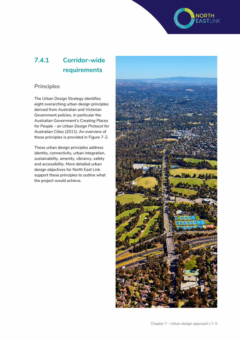
7.4.1 Corridor-wide requirements
Principles
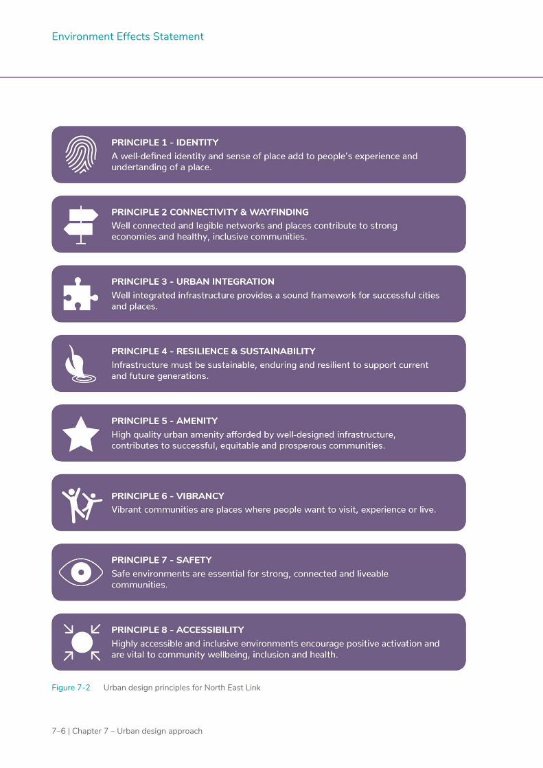
The Urban Design Strategy identifies eight overarching urban design principles derived from Australian and Victorian Government policies, in particular the Australian Government’s Creating Places for People – an Urban Design Protocol for Australian Cities (2011). An overview of these principles is provided in Figure 7-2.
These urban design principles address identity, connectivity, urban integration, sustainability, amenity, vibrancy, safety and accessibility. More detailed urban design objectives for North East Link support these principles to outline what the project would achieve.
Environment Effects Statement
7–6 | Chapter 7 – Urban design approach
Figure 7-2 Urban design principles for North East Link
Chapter 7 – Urban design approach | 7–7
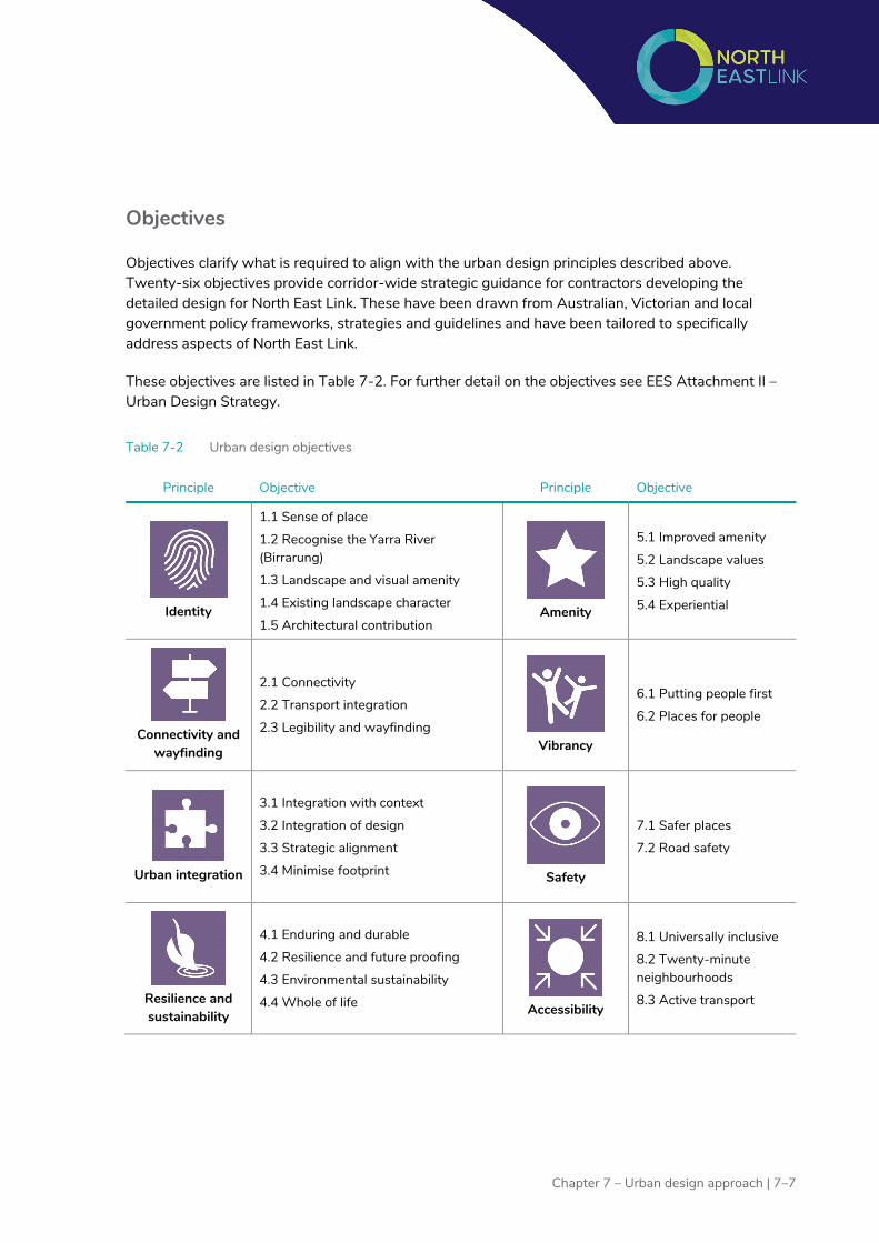
Objectives
Objectives clarify what is required to align with the urban design principles described above. Twenty-six objectives provide corridor-wide strategic guidance for contractors developing the detailed design for North East Link. These have been drawn from Australian, Victorian and local government policy frameworks, strategies and guidelines and have been tailored to specifically address aspects of North East Link.
These objectives are listed in Table 7-2. For further detail on the objectives see EES Attachment II – Urban Design Strategy.
Table 7-2 Urban design objectives
Principle Objective Principle Objective
Identity
1.1 Sense of place 1.2 Recognise the Yarra River (Birrarung) 1.3 Landscape and visual amenity
1.4 Existing landscape character
1.5 Architectural contribution
Amenity
5.1 Improved amenity
5.2 Landscape values 5.3 High quality
5.4 Experiential
Connectivity and
wayfinding
2.1 Connectivity
2.2 Transport integration
2.3 Legibility and wayfinding Vibrancy
6.1 Putting people first 6.2 Places for people
Urban integration
3.1 Integration with context
3.2 Integration of design 3.3 Strategic alignment
3.4 Minimise footprint
Safety
7.1 Safer places 7.2 Road safety
Resilience and sustainability
4.1 Enduring and durable 4.2 Resilience and future proofing
4.3 Environmental sustainability
4.4 Whole of life
Accessibility
8.1 Universally inclusive 8.2 Twenty-minute neighbourhoods
8.3 Active transport
Environment Effects Statement
7–8 | Chapter 7 – Urban design approach
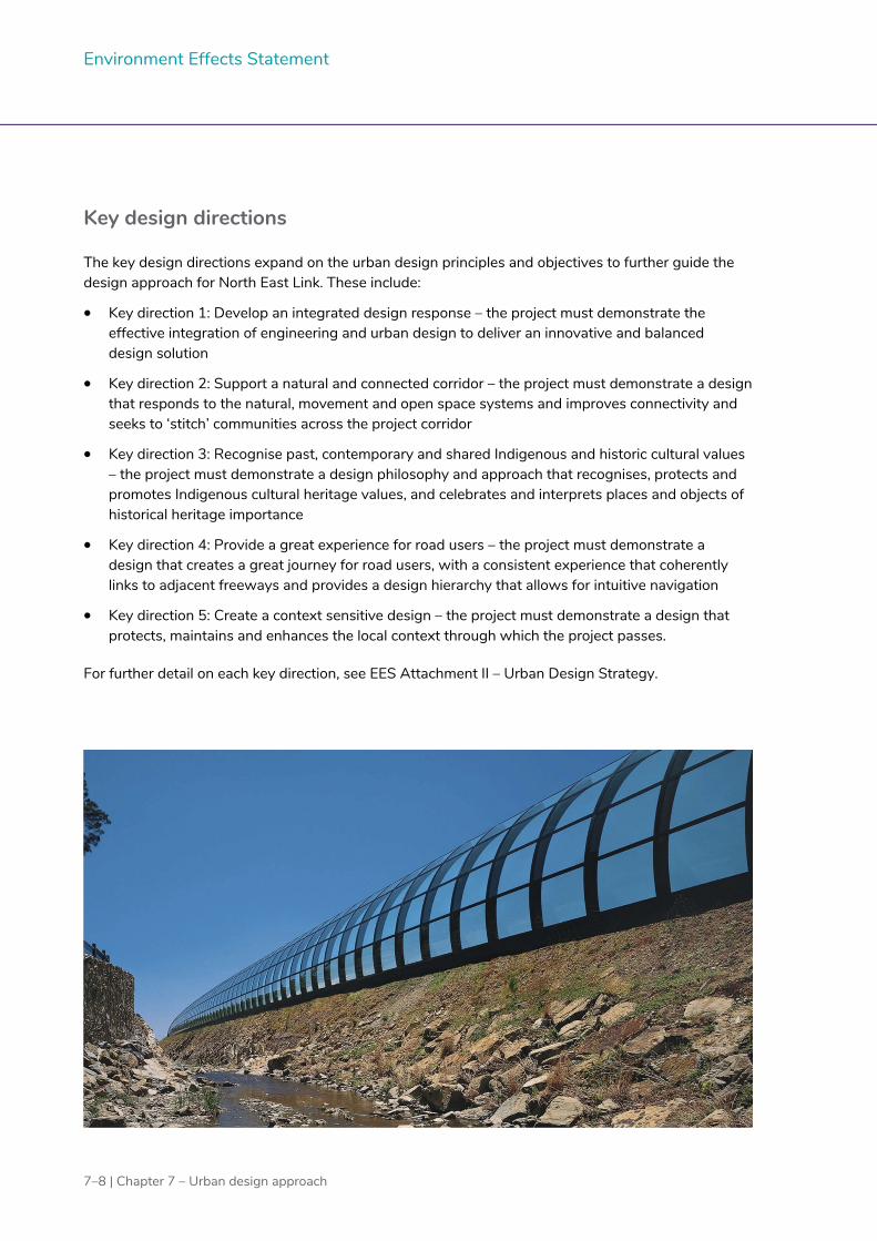
Key design directions
The key design directions expand on the urban design principles and objectives to further guide the design approach for North East Link. These include:
• Key direction 1: Develop an integrated design response – the project must demonstrate the effective integration of engineering and urban design to deliver an innovative and balanced design solution
• Key direction 2: Support a natural and connected corridor – the project must demonstrate a design that responds to the natural, movement and open space systems and improves connectivity and seeks to ‘stitch’ communities across the project corridor
• Key direction 3: Recognise past, contemporary and shared Indigenous and historic cultural values – the project must demonstrate a design philosophy and approach that recognises, protects and promotes Indigenous cultural heritage values, and celebrates and interprets places and objects of historical heritage importance
• Key direction 4: Provide a great experience for road users – the project must demonstrate a design that creates a great journey for road users, with a consistent experience that coherently links to adjacent freeways and provides a design hierarchy that allows for intuitive navigation
• Key direction 5: Create a context sensitive design – the project must demonstrate a design that protects, maintains and enhances the local context through which the project passes.
For further detail on each key direction, see EES Attachment II – Urban Design Strategy.
Chapter 7 – Urban design approach | 7–9
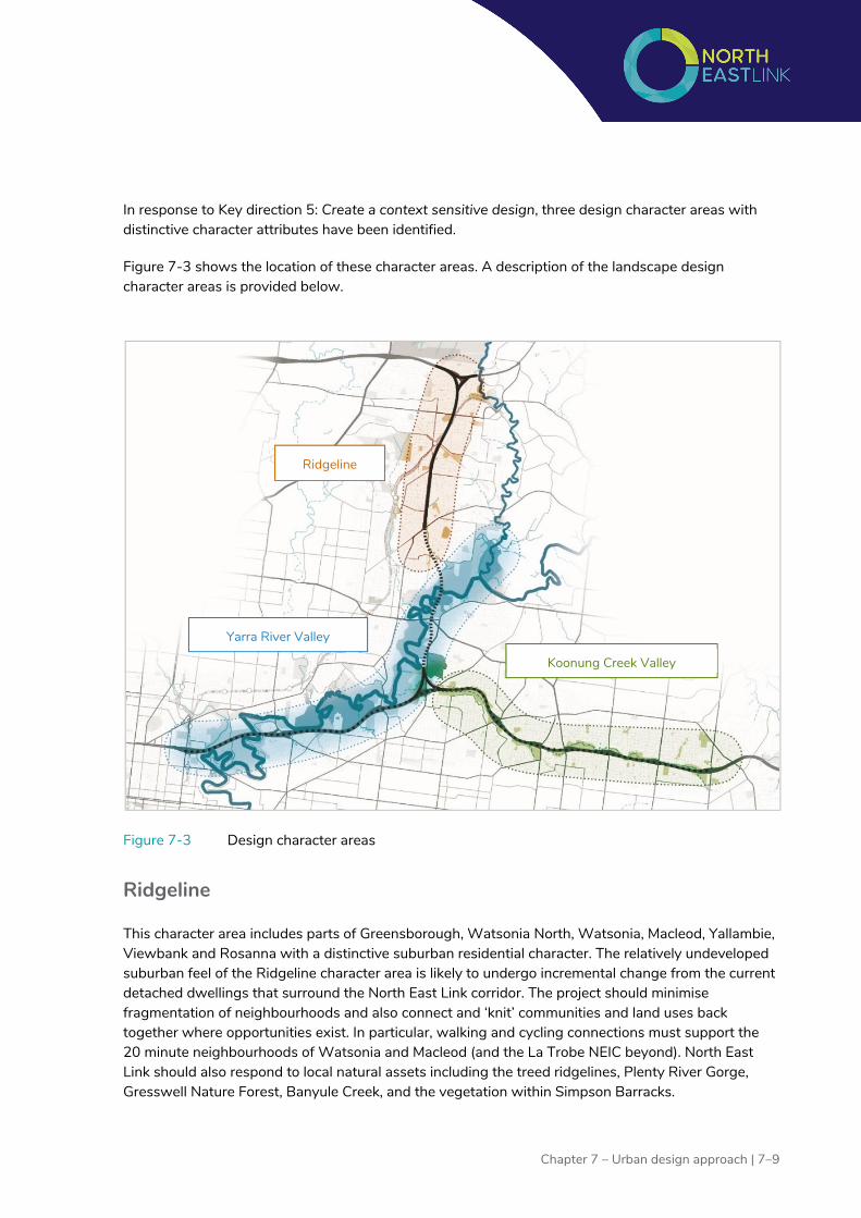
In response to Key direction 5: Create a context sensitive design, three design character areas with distinctive character attributes have been identified.
Figure 7-3 shows the location of these character areas. A description of the landscape design character areas is provided below.
Figure 7-3 Design character areas
Ridgeline
This character area includes parts of Greensborough, Watsonia North, Watsonia, Macleod, Yallambie, Viewbank and Rosanna with a distinctive suburban residential character. The relatively undeveloped suburban feel of the Ridgeline character area is likely to undergo incremental change from the current detached dwellings that surround the North East Link corridor. The project should minimise fragmentation of neighbourhoods and also connect and ‘knit’ communities and land uses back together where opportunities exist. In particular, walking and cycling connections must support the 20 minute neighbourhoods of Watsonia and Macleod (and the La Trobe NEIC beyond). North East Link should also respond to local natural assets including the treed ridgelines, Plenty River Gorge, Gresswell Nature Forest, Banyule Creek, and the vegetation within Simpson Barracks.
Ridgeline
Yarra River Valley
Koonung Creek Valley
Environment Effects Statement
7–10 | Chapter 7 – Urban design approach
Yarra River Valley
This character area follows the Yarra River from Viewbank through the Banyule Flats, Warringal Parklands, the Yarra River Parklands to Kew and Fairfield. Landscapes within this character area have high cultural heritage significance and are open, vegetated and naturalistic landscapes. North East Link should be well integrated and responsive to the distinctive setting as well as the future context of the area, particularly the social and environmental values of the Greater Yarra Urban Parklands. Within this character area, it is a priority to provide enhanced crossings and connections to natural assets, facilities, open spaces and cultural places in Bulleen, to respect the design qualities of the original section of the Eastern Freeway built in 1977, and to maximise cycle and pedestrian access and connections across the Eastern Freeway.
Koonung Creek Valley
This character area follows the Koonung Creek east through Balwyn North, Doncaster, Box Hill North, Nunawading and Blackburn North and is characterised by low density suburban residential dwellings. The upgrades to the Eastern Freeway as part of North East Link would widen the existing freeway corridor which would move transport infrastructure closer to residents, impact the existing roadside landscape and encroach into open space. Within this character area, opportunities to connect the communities to facilities to the north and south of the Eastern Freeway would be maximised. This could be achieved with enhanced crossings by maximising cycling and pedestrian access and connections across the freeway. North East Link would continue to support active transport and use of open space along the Koonung Creek Trail and across the Eastern Freeway by maintaining and/or improving connections. North East Link would also be designed to respect the existing noise walls and bridges.
7.4.2 Place-specific requirements
Place-specific requirements are used to deliver a contextually responsive project solution and to guide how design is informed and evaluated in local places.
The three design character areas have been used as a framework for developing place-specific requirements that must be met and considered at specific locations within each character area. These requirements respond to the local context, unique characteristics, uses and significant elements of each design character area.
To inform the preparation of the place-specific requirements, a landscape context analysis, review of relevant Council plans and strategies, and extensive stakeholder and community engagement has been undertaken. Stakeholder engagement has been an extremely significant component of this process so the community’s expectations and local level issues are considered in the design.
Chapter 7 – Urban design approach | 7–11
The preparation of the EES has also informed the development of the place-specific requirements through the identification of key impacts and opportunities associated with the reference project. Where the detailed design would respond to and mitigate these impacts, place-specific performance requirements have been developed to inform the contractor’s design solution. This also provides good guidance for achieving improved visual amenity, transport linkages, community linkages and land use as identified in Chapter 9 – Traffic and transport, Chapter 13 – Land use planning, Chapter 16 – Landscape and visual, and Chapter 17 – Social.
To provide additional guidance for project tenderers, these place-specific requirements have been categorised under the most relevant urban design principle, acknowledging that the requirements may relate to multiple principles. Items listed in italics within the Urban Design Strategy also describe opportunities which are outside the scope of North East Link that would be beneficial for contractors to implement.
7.4.3 Detailed requirements and benchmarks
Informed by the corridor wide and place-specific requirements, the Urban Design Strategy also outlines detailed requirements that apply to the whole project. These are specific to elements of North East Link such as elevated roads, bridges, tunnels, ventilation structures, noise walls and other key infrastructure components.
Qualitative benchmarks illustrate the minimum standard of design quality for project tenders. Drawn from relevant previous transport infrastructure projects, the qualitative benchmarks illustrate examples of the level of design quality required for elements such as land bridges, open cuttings, public realm and other key infrastructure elements of these projects.
This section of the Urban Design Strategy also includes requirements around managing construction impacts. These focus on accessibility, community functions, amenity, landscaping, consultation with key stakeholders and public information for communities.
For further detail on the detailed requirements and benchmarks see EES Attachment II – Urban Design Strategy.
Environment Effects Statement
7–12 | Chapter 7 – Urban design approach
7.5 Conclusion NELP is committed to providing high-quality design outcomes for North East Link as part of a legacy for a more connected, smarter, more efficient Melbourne and Victoria. Urban design is both a process and an outcome and the development of the Urban Design Strategy has facilitated the early integration of urban design thinking at the outset of the planning and design process for North East Link.
While the Urban Design Strategy sets the strategic direction and overarching urban design requirements for North East Link, it is not intended to communicate design plans or proposals. The contractors' design would be prepared in response to the Urban Design Strategy and assessed against the stated design requirements in the strategy.
UDAP would have an ongoing role of reviewing the urban design before advising the Minister for Planning on the final approval of the Urban Design and Landscape Plans. This would guide the process to assess the contractors' design against the requirements and benchmarks set by the Urban Design Strategy.
Given the scale, complexity and extent of the infrastructure associated with North East Link, an integrated design solution is essential to enable the project to move beyond an efficient traffic outcome. As a city-shaping project, North East Link looks to prioritise an architecturally significant design that recognises the connection between people, places and the natural environment, leaving a positive legacy for Melbourne.