Embed Size (px)
Citation preview
95959595951
2012 City of Kitchener Urban Design Manual – Part B: Design Briefs B-95
Urban Design Manual
96969696961
2012 City of Kitchener Urban Design Manual – Part B: Design Briefs B-96
Urban Design Manual
5.0
SUBURBAN DEVELOPMENT & NEIGHBOURHOOD MIXED USE CENTRES
5.0.1 INTRODUCTION
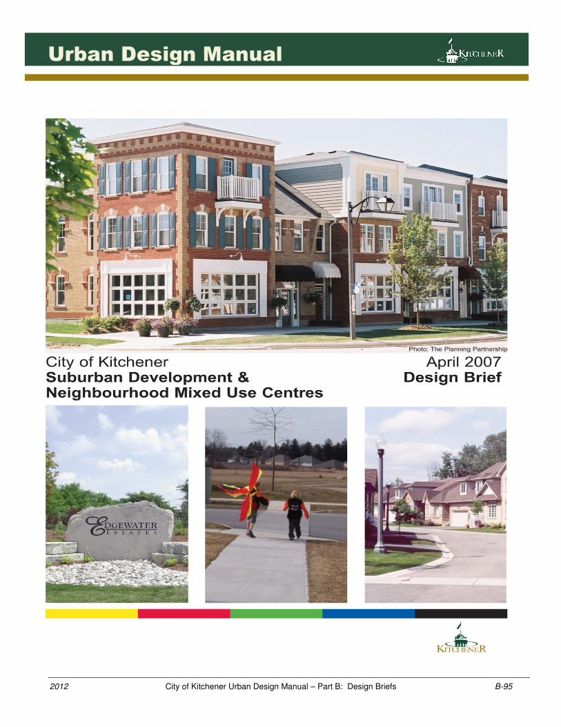
The City of Kitchener is committed to ensuring that its residents enjoy a high quality of life through the creation of attractive, walkable neighbourhoods that contribute to complete communities, particularly new neighbourhoods being developed in designated greenfield areas.
The City’s Urban Design Manual has been updated to include a Design Brief that provides a comprehensive set of design guidelines for new development located in the City’s Suburban Neighbourhoods or within the City’s Neighbourhood Mixed Use Centre land use designation. This Design Brief states the City’s design expectations for new development with focus given to primary structural elements such as existing site conditions, street design and parks hierarchy, and to specific secondary design elements such as streetscape design, built form, building design and park design.
5.0.2 Design Brief Organization This Design Brief is organized into three sections with corresponding sub sections. The first section, Introduction, provides a brief overview of the Design Brief in terms of its context, purpose and primary design objectives.
The second section, Suburban Development Guidelines, includes a series of design guidelines organized into four sub sections which support the primary design objectives. The first sub section is creating walkable neighbourhoods, followed by establishing neighbourhood structure, reinforcing neighbourhood character and liveability, and lastly, integrated neighbourhood mixed use centre which addresses commercial or mixed use development planning within or adjacent to neighbourhoods. Numerous guidelines also include supplemental guidance in the form of “guidelines tips” and
“references” to assist with guideline implementation and the approvals process. The Guideline Tips refer to specific actions that an applicant or City staff may be required to perform to achieve the guidelines. Key references have also been identified for important guidelines to direct users to relevant documents. The references have only been identified for select guidelines and will be updated through future updates to this Design Brief.
Walkable neighbourhoods with central park spaces
contribute to complete communities (Markham, ON).
The City’s Suburban Neighbourhoods are located at the
outer portions of the city as shown above.
97979797971
2012 City of Kitchener Urban Design Manual – Part B: Design Briefs B-97
Urban Design Manual
The third section, Implementation, describes how the Design Brief will be incorporated into the City’s approval processes and provides supplementary information related to the Demonstration Plan, supporting technical information and a glossary of terms to explain key terms in this Brief.
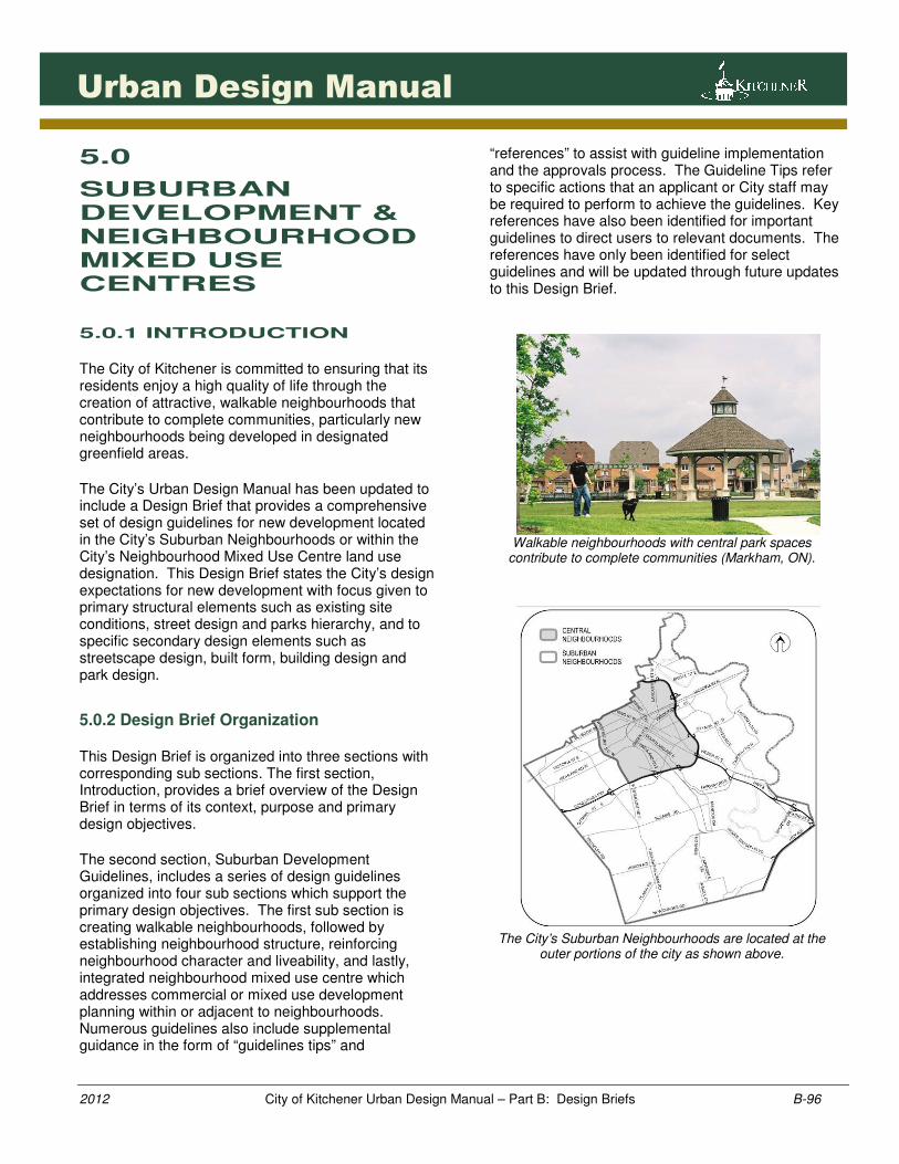
5.0.3 Context The City of Kitchener has a diverse range of suburban neighbourhoods. These neighbourhoods continue to evolve and present new design challenges. In the early 2000s, Kitchener experienced challenges related to on-street parking, accessibility to active park spaces, shops and transit routes, general woodland and tree conservation, emerging housing types and trends resulting in car-oriented streetscapes and the integration of roundabout intersections. The City has undertaken numerous initiatives to improve the quality of life for its citizens. Specific initiatives include the Environics Survey, the adoption of a Pedestrian Charter and the Healthy Communities Plan. This Design Brief has been prepared to support these initiatives. The City is also experiencing additional changes related to local, regional and provincial growth management strategies. Of particular note, The Places to Grow Growth Plan provides specific direction for development taking place in designated Greenfield Areas and desire for Complete Communities. This Design Brief presents a progressive design strategy to assist with these initiatives.
5.0.4 Purpose The primary purpose of this Design Brief is to:
• provide a tool for implementing the planning
principles in the City’s Municipal Plan and
specifically Urban Design policies in Part II –
Sections 1.4 and 6.0;
• provide design guidelines to implement the
Neighbourhood Mixed Use Centre land use
designation.
• provide a tool for implementing specific sections in
the Urban Design Manual;
• provide a tool to assist municipal staff, agencies
and the development industry to implement the
Places to Grow Growth Plan with emphasis on
creating complete communities; and
• establish a design-based approach to
neighbourhood planning and development and to
continually improve the quality of neighbourhoods
by promoting a greater variety of design solutions.
The City of Kitchener has experienced strong demand for smaller lot housing resulting in car-oriented streetscapes.
Places To Grow Growth Plan, Policy 2.2.7 (2006):
1. “New development taking place in designated
greenfield areas will be planned, designated, zoned and
designed in a manner that -
a) contributes to creating complete communities;
b) creates street configurations, densities and an
urban form that support walking, cycling, and
the early integration and sustained viability of
transit services;
c) provides a diverse mix of land uses, including
residential and employment uses, to support
vibrant neighbourhoods;
d) creates high quality public open spaces with
site design and urban design standards that
support opportunities for transit, walking and
cycling.”
City of Kitchener Municipal Plan – Neighbourhood
Quality, Policy 1.4:
1.0 “The City is strongly committed to excellence in
community design as a way of creating and maintaining
pleasant, attractive and functional neighbourhoods. The
City shall take an active role in identifying, evaluating,
developing and implementing improved community
design approaches.”
98989898981
2012 City of Kitchener Urban Design Manual – Part B: Design Briefs B-98
Urban Design Manual
5.0.5 Primary Design Objective
The Design Brief is based on contemporary design principles and clear objectives that were prepared in the context of development experiences in Kitchener and other cities across Ontario. They also reflect regional and provincial growth plan strategies, the City’s Municipal Plan policies, a comprehensive public survey on neighbourhood design and continued updates to the City’s Urban Design Manual. The primary design objectives for this Design Brief are identified below: 1. Walkability: to create walkable neighbourhoods
that are well connected and fully accessible to major destinations and surrounding neighbourhoods.
2. Variety: to build neighbourhoods that provide a
range of housing types, park and open spaces and neighbourhood focal points.
3. Placemaking: to create streetscape quality, and
contribute to neighbourhood character and sense of place.
4. Conservation: to conserve, protect and integrate
existing natural and cultural heritage resources. 5. Connectivity: to provide multiple route options
for all modes of travel. 6. Transit Supportive: to design and build
neighbourhoods that provide greater opportunity for transit usage.
7. Safety: to promote design practices that
contribute to neighbourhood safety. 8. Balance: to promote neighbourhood design
quality through a balanced approach with economic considerations.
9. Liveability: to promote design solutions that
contributes to sustainable practices, the celebration of arts and culture, healthy and complete communities.
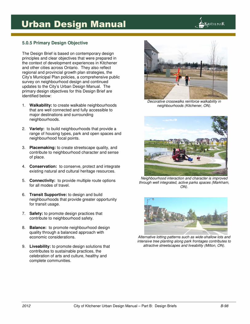
Decorative crosswalks reinforce walkability in
neighbourhoods (Kitchener, ON).
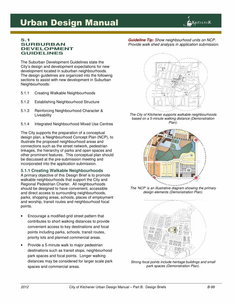
Neighbourhood interaction and character is improved
through well integrated, active parks spaces (Markham, ON).
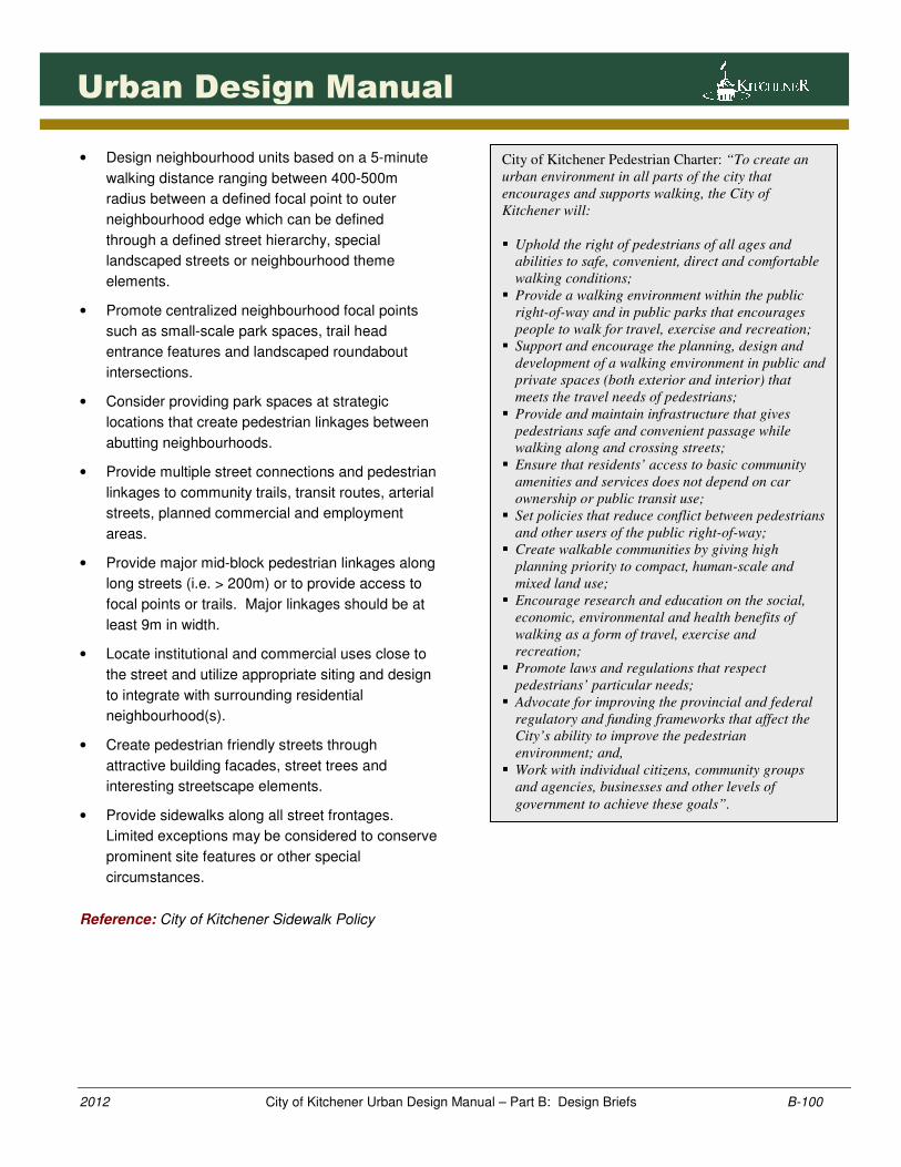
Alternative lotting patterns such as wide-shallow lots and intensive tree planting along park frontages contributes to
attractive streetscapes and liveability (Milton, ON).
99999999991
2012 City of Kitchener Urban Design Manual – Part B: Design Briefs B-99
Urban Design Manual
5.1 SURBURBAN DEVELOPMENT GUIDELINES The Suburban Development Guidelines state the City’s design and development expectations for new development located in suburban neighbourhoods. The design guidelines are organized into the following sections to assist with new development in Suburban Neighbourhoods: 5.1.1 Creating Walkable Neighbourhoods 5.1.2 Establishing Neighbourhood Structure 5.1.3 Reinforcing Neighbourhood Character &
Liveability 5.1.4 Integrated Neighbourhood Mixed Use Centres The City supports the preparation of a conceptual design plan, a Neighbourhood Concept Plan (NCP), to illustrate the proposed neighbourhood areas and connections such as the street network, pedestrian linkages, the hierarchy of parks and open spaces and other prominent features. This conceptual plan should be discussed at the pre-submission meeting and incorporated into the application submission.
5.1.1 Creating Walkable Neighbourhoods A primary objective of this Design Brief is to promote walkable neighbourhoods that support the City and Regional Pedestrian Charter. All neighbourhoods should be designed to have convenient, accessible and direct access to surrounding neighbourhoods, parks, shopping areas, schools, places of employment and worship, transit routes and neighbourhood focal points.
• Encourage a modified-grid street pattern that
contributes to short walking distances to provide
convenient access to key destinations and focal
points including parks, schools, transit routes,
priority lots and planned commercial areas.
• Provide a 5-minute walk to major pedestrian
destinations such as transit stops, neighbourhood
park spaces and focal points. Longer walking
distances may be considered for larger scale park
spaces and commercial areas.
Guideline Tip: Show neighbourhood units on NCP. Provide walk shed analysis in application submission.
The City of Kitchener supports walkable neighbourhoods
based on a 5-minute walking distance (Demonstration Plan).
The ‘NCP’ is an illustrative diagram showing the primary
design elements (Demonstration Plan).
Strong focal points include heritage buildings and small
park spaces (Demonstration Plan).
1001001001001001
2012 City of Kitchener Urban Design Manual – Part B: Design Briefs B-100
Urban Design Manual
• Design neighbourhood units based on a 5-minute
walking distance ranging between 400-500m
radius between a defined focal point to outer
neighbourhood edge which can be defined
through a defined street hierarchy, special
landscaped streets or neighbourhood theme
elements.
• Promote centralized neighbourhood focal points
such as small-scale park spaces, trail head
entrance features and landscaped roundabout
intersections.
• Consider providing park spaces at strategic
locations that create pedestrian linkages between
abutting neighbourhoods.
• Provide multiple street connections and pedestrian
linkages to community trails, transit routes, arterial
streets, planned commercial and employment
areas.
• Provide major mid-block pedestrian linkages along
long streets (i.e. > 200m) or to provide access to
focal points or trails. Major linkages should be at
least 9m in width.
• Locate institutional and commercial uses close to
the street and utilize appropriate siting and design
to integrate with surrounding residential
neighbourhood(s).
• Create pedestrian friendly streets through
attractive building facades, street trees and
interesting streetscape elements.
• Provide sidewalks along all street frontages.
Limited exceptions may be considered to conserve
prominent site features or other special
circumstances.
Reference: City of Kitchener Sidewalk Policy
City of Kitchener Pedestrian Charter: “To create an
urban environment in all parts of the city that
encourages and supports walking, the City of
Kitchener will:
� Uphold the right of pedestrians of all ages and
abilities to safe, convenient, direct and comfortable
walking conditions;
� Provide a walking environment within the public
right-of-way and in public parks that encourages
people to walk for travel, exercise and recreation;
� Support and encourage the planning, design and
development of a walking environment in public and
private spaces (both exterior and interior) that
meets the travel needs of pedestrians;
� Provide and maintain infrastructure that gives
pedestrians safe and convenient passage while
walking along and crossing streets;
� Ensure that residents’ access to basic community
amenities and services does not depend on car
ownership or public transit use;
� Set policies that reduce conflict between pedestrians
and other users of the public right-of-way;
� Create walkable communities by giving high
planning priority to compact, human-scale and
mixed land use;
� Encourage research and education on the social,
economic, environmental and health benefits of
walking as a form of travel, exercise and
recreation;
� Promote laws and regulations that respect
pedestrians’ particular needs;
� Advocate for improving the provincial and federal
regulatory and funding frameworks that affect the
City’s ability to improve the pedestrian
environment; and,
� Work with individual citizens, community groups
and agencies, businesses and other levels of
government to achieve these goals”.
1011011011011011
2012 City of Kitchener Urban Design Manual – Part B: Design Briefs B-101
Urban Design Manual
5.1.2 Establishing Neighbourhood Structure (Primary Design Elements) Neighbourhood form, function and character is largely influenced through the sensitive integration of existing site features in combination with several other primary design elements such as the street hierarchy, the lotting pattern, the parks hierarchy and gateway features. Neighbourhood structural elements should relate to the larger community structure as noted in the Urban Design Manual.
Existing Site Features
• Conserve and integrate (where appropriate)
natural features such as hedgerows, mature trees,
woodlands, valleylands and wetlands through land
dedications, creative parks and open space
planning, street alignments such as single-loaded
streets or alternative lotting or floor plan
configurations.
Guideline Tip: Prepare ‘Existing Conditions Plan’ showing existing grades, existing site features such as woodlands, trees, cultural heritage resources and prominent views/vistas. This plan should be discussed at the pre-submission meeting and incorporated into the NCP. Guideline Tip: Prepare Conceptual Grading Plan that illustrates existing and then proposed grades in relation to site features and confirms opportunity to integrate site features through sensitive grading proposals. Discuss grading plan implications during pre-submission meeting. Reference: City of Kitchener Tree Management Policy
• Identify existing cultural heritage resources and
determine appropriate conservation techniques.
Preferably, these resources should be conserved
on their original sites (in situ). Alternative
conservation options may be considered subject to
study and analysis such as through a Heritage
Impact Assessment (HIA).
Guideline Tip: Prepare ‘HIA’ early in the design process. The ‘HIA’ could be in two phases – Phase I: identification and description of the heritage resource and attributes and recommended options including
conservation. Phase II: at such time as the development proposal moves forward to detailed design, the design would be confirmed with the City to address implementation design guidelines and investigation.
Single loaded streets provides an effective strategy to maintain the integrity of sensitive environmental features
and promote prominent views (Markham, ON).
Alterative lotting patterns, such as lane based
development, provides one strategy to conserve existing trees along major streets
(Markham, ON).
Provincial Policy Statement– Section 2.1
(2005):
2.1.1 Natural features and areas shall be
protected for the long term.
2.1.2 The diversity and connectivity of
natural areas in an area, and the
long-term ecological function and
biodiversity of natural heritage
systems, should be maintained,
restored or, where possible,
improved, recognizing linkages
between and among natural
heritage features and areas, surface
water features and ground water
features.
1021021021021021
2012 City of Kitchener Urban Design Manual – Part B: Design Briefs B-102
Urban Design Manual
• Encourage views and vistas to prominent site
features such as woodlands, watercourses and
heritage resources. This could be accomplished
through the strategic location of park and open
spaces and street design such as single-loaded
streets.
• Provide buffer area around existing natural
features, such as woodlands and significant
wetlands, to minimize edge impacts and to help
ensure conservation of the feature. Ensure that
lots and blocks for development are created
outside the established buffer area.
Guideline Tip: Identify buffer areas on ‘NCP’. Identify and discuss buffer area strategies during pre-submission meeting. Prepare EIS or similar analysis and submit with development application to help determine buffer requirements. Guideline Tip: Zone buffer areas as Open Space.
• Encourage innovative design strategies and
Stormwater Management (SWM) techniques for
developments located within sensitive ground
water recharge areas. Specific design strategies
may include alternative street and lotting patterns,
infiltration galleries or greenway system.
Guideline Tip: Follow Subwatershed or similar drainage studies to implement recommended design and engineering techniques early in the development process through the design of the plan, engineering drawings and/or conditions of approval. In certain groundwater recharge sensitive areas, specific engineering studies may be required with application submission.
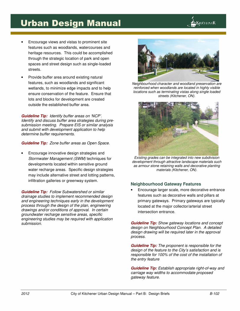
Neighbourhood character and woodland preservation are reinforced when woodlands are located in highly visible locations such as terminating vistas along single loaded
streets (Kitchener, ON).
Existing grades can be integrated into new subdivision
development through attractive landscape materials such as armour stone retaining walls and decorative planting
materials (Kitchener, ON).
Neighbourhood Gateway Features
• Encourage larger scale, more decorative entrance
features such as decorative walls and pillars at
primary gateways. Primary gateways are typically
located at the major collector/arterial street
intersection entrance.
Guideline Tip: Show gateway locations and concept design on Neighbourhood Concept Plan. A detailed design drawing will be required later in the approval process. Guideline Tip: The proponent is responsible for the design of the feature to the City’s satisfaction and is responsible for 100% of the cost of the installation of the entry feature Guideline Tip: Establish appropriate right-of-way and carriage way widths to accommodate proposed gateway feature.
1031031031031031
2012 City of Kitchener Urban Design Manual – Part B: Design Briefs B-103
Urban Design Manual
• Provide smaller scale, lower maintenance
entrance features at secondary gateways.
Encourage natural landscape features such as
rocks or stone and drought tolerant ground cover
and street trees.
• Locate gateway features along major streets.
• Encourage coordinated gateway themes through
use of similar landscape materials, public art,
signage, decorative lighting and other streetscape
elements.
Reference: City of Kitchener Public Art Policy Reference: City of Kitchener Culture Plan II
• Locate above-ground utilities away from gateway
entrances, street intersections or public spaces.
• Encourage front-lotted development along
gateway entrances and provide architecturally
enhanced, well articulated building elevations that
contribute to a sense of place and neighbourhood
entrance.
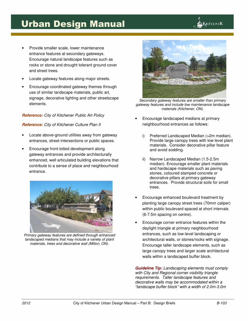
Primary gateway features are defined through enhanced landscaped medians that may include a variety of plant
materials, trees and decorative wall (Milton, ON).
Secondary gateway features are smaller than primary
gateway features and include low maintenance landscape materials (Kitchener, ON).
• Encourage landscaped medians at primary
neighbourhood entrances as follows:
i) Preferred Landscaped Median (>2m median).
Provide large canopy trees with low level plant materials. Consider decorative pillar feature and avoid sodding.
ii) Narrow Landscaped Median (1.5-2.5m median). Encourage smaller plant materials and hardscape materials such as paving stones, coloured stamped concrete or decorative pillars at primary gateway entrances. Provide structural soils for small trees.
• Encourage enhanced boulevard treatment by
planting large canopy street trees (70mm caliper)
within public boulevard spaced at short intervals
(6-7.5m spacing on centre).
• Encourage corner entrance features within the
daylight triangle at primary neighbourhood
entrances, such as low-level landscaping or
architectural walls, or stones/rocks with signage.
Encourage taller landscape elements, such as
large canopy trees and larger scale architectural
walls within a landscaped buffer block.
Guideline Tip: Landscaping elements must comply with City and Regional corner visibility triangle requirements. Taller landscape features and decorative walls may be accommodated within a “landscape buffer block” with a width of 2.0m-3.0m
1041041041041041
2012 City of Kitchener Urban Design Manual – Part B: Design Briefs B-104
Urban Design Manual
beyond the visibility triangle. The block could either be a common element condominium, a block dedicated to the appropriate road authority (typically City) or an easement in favour of the City. Identify landscape buffer blocks on subdivision plans. References: City of Kitchener Zoning By-law, Section 4. City of Kitchener Municipal Code, Chapter 842.
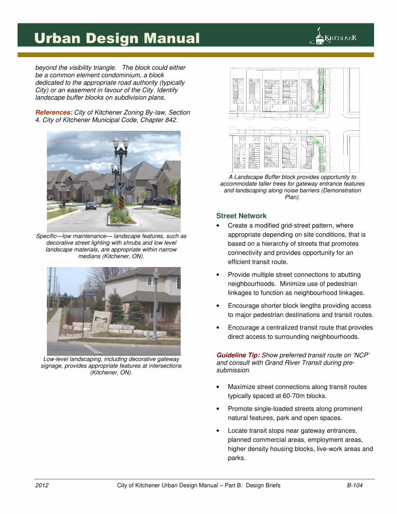
Specific—low maintenance— landscape features, such as
decorative street lighting with shrubs and low level landscape materials, are appropriate within narrow
medians (Kitchener, ON).
Low-level landscaping, including decorative gateway
signage, provides appropriate features at intersections (Kitchener, ON).
A Landscape Buffer block provides opportunity to
accommodate taller trees for gateway entrance features and landscaping along noise barriers (Demonstration
Plan).
Street Network
• Create a modified grid-street pattern, where
appropriate depending on site conditions, that is
based on a hierarchy of streets that promotes
connectivity and provides opportunity for an
efficient transit route.
• Provide multiple street connections to abutting
neighbourhoods. Minimize use of pedestrian
linkages to function as neighbourhood linkages.
• Encourage shorter block lengths providing access
to major pedestrian destinations and transit routes.
• Encourage a centralized transit route that provides
direct access to surrounding neighbourhoods.
Guideline Tip: Show preferred transit route on ‘NCP’ and consult with Grand River Transit during pre-submission.
• Maximize street connections along transit routes
typically spaced at 60-70m blocks.
• Promote single-loaded streets along prominent
natural features, park and open spaces.
• Locate transit stops near gateway entrances,
planned commercial areas, employment areas,
higher density housing blocks, live-work areas and
parks.
1051051051051051
2012 City of Kitchener Urban Design Manual – Part B: Design Briefs B-105
Urban Design Manual
• Encourage creative street alignments to reinforce
neighbourhood focal points and priority streets.
‘Arterial Streets’ (30 – 35m ROW, 5,000-12,000 AADT)
• Create a local street system that is integrated with
the arterial street with multiple points of access
ranging between 200-400m in length.
• Promote direct driveway access for higher density
residential, commercial or employment uses that
contributes to an integrated street network system.
• Promote attractive streetscapes through a variety
of design solutions which may include landscaped
buffer blocks, decorative fencing, centre
landscaped medians, enhanced streetscape
elements and front-lotted development or use of
window streets.
• Provide clear and direct pedestrian access to
arterial streets through a variety of street or block
designs.
‘Collector Streets’ (20 -26m ROW, <8,000 AADT)
• Consider a variety of collector street hierarchies to
accommodate bicycle lanes, on-street parking,
shared bike/parking lanes, streetscape elements
and transit.
References: City of Kitchener Subdivision Manual
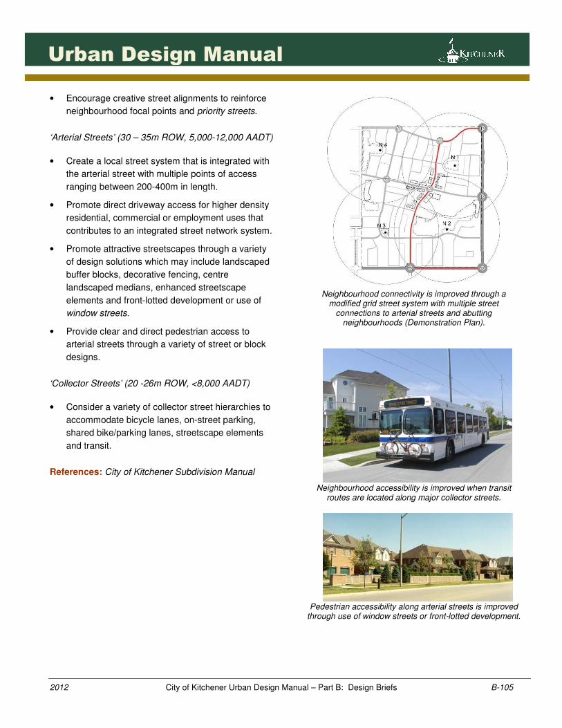
Neighbourhood connectivity is improved through a
modified grid street system with multiple street connections to arterial streets and abutting
neighbourhoods (Demonstration Plan).
Neighbourhood accessibility is improved when transit
routes are located along major collector streets.
Pedestrian accessibility along arterial streets is improved
through use of window streets or front-lotted development.
1061061061061061
2012 City of Kitchener Urban Design Manual – Part B: Design Briefs B-106
Urban Design Manual
• Encourage enhanced landscape boulevard
treatments and functions along the primary
collector street such as bicycle lanes and primary
gateway features.
• Encourage dedicated bicycle lanes (1.2-1.5m
lanes) along primary collector roads, to streets
providing access to major trails, employment and
to regional bicycle lanes. Encourage existing or
planned bicycle routes to be extended in future
plans.
References: City & Regional Bicycle Master Plans.
• Provide crosswalks at controlled locations and in
areas of major pedestrian crossings.
• Encourage collector streets to bend slightly to
create changing views.
• Promote consistent traffic calming measures.
Local Streets (18 m ROW, <2,000 AADT)
• Consider reduced/narrow ROW for local streets,
cul-de-sac streets, single loaded streets and
alternative lotting patterns, where appropriate.
Ensure on-street parking requirements are
accommodated.
Guideline Tip: Discuss proposed alternative development standards early in the design process with City staff to determine if acceptable in the specific site circumstances.
• Block length should generally not exceed 200-
250m in length unless site features or other
special circumstances dictate otherwise.
• Design streets to terminate at public buildings,
park spaces, other focal points and vistas.
• Consider street alignments carefully to address
existing site features.
Priority Streets
• Identify the prominent streets through a
neighbourhood as ‘priority streets’.
Guideline Tip: Priority streets should be shown on the NCP.
• Carefully consider the street function, lotting
pattern, intersection design, entrance features and
the provision of enhanced landscape elements
along priority streets.
Guideline Tip: A ‘Streetscape Plan’ may be required as a condition of approval to ensure coordination of streetscape elements on priority streets.
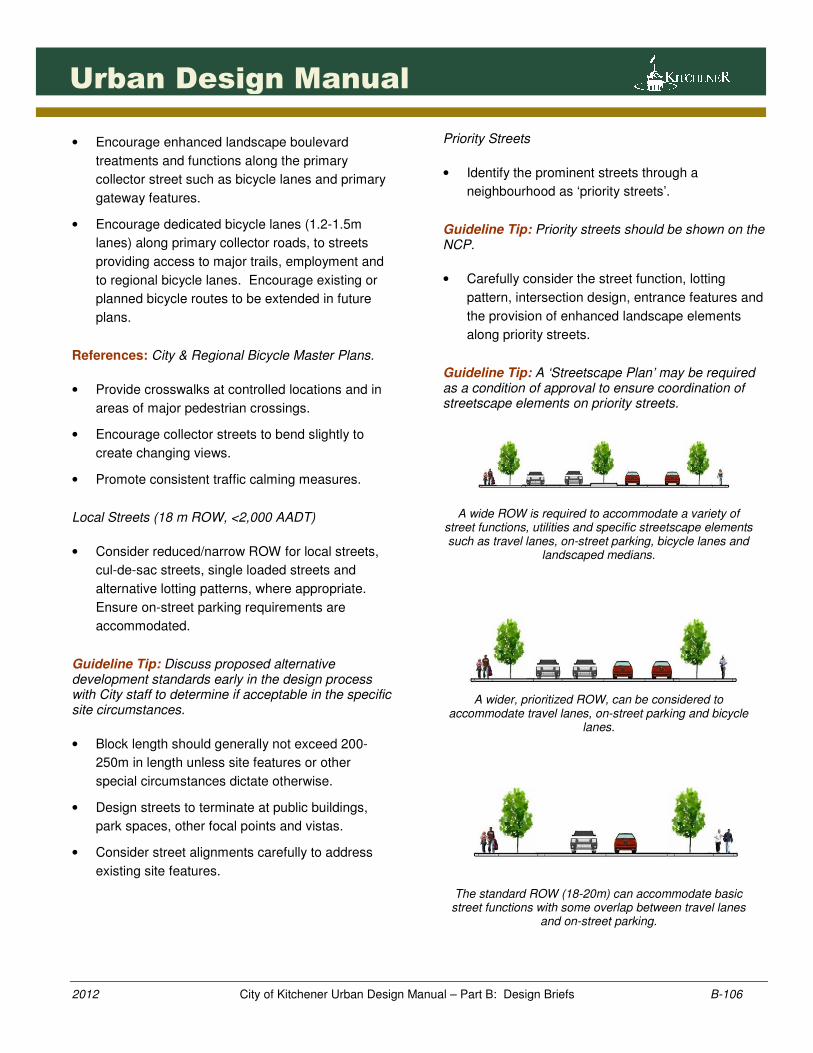
A wide ROW is required to accommodate a variety of
street functions, utilities and specific streetscape elements such as travel lanes, on-street parking, bicycle lanes and
landscaped medians.
A wider, prioritized ROW, can be considered to
accommodate travel lanes, on-street parking and bicycle lanes.
The standard ROW (18-20m) can accommodate basic street functions with some overlap between travel lanes
and on-street parking.
1071071071071071
2012 City of Kitchener Urban Design Manual – Part B: Design Briefs B-107
Urban Design Manual
Alterative streetscape elements such as landscape
medians distinguish priority streets from other neighbourhood streets (Markham, ON).
Traffic Calming & Street Intersection Design
• Consider a variety of traffic calming measures
within the proposed street network such as
mechanisms and landscaped medians.
Guideline Tip: Show proposed traffic calming locations on ‘NCP’ and ensure appropriate ‘ROW’ is provided. Guideline Tip: A detailed functional design will be required as a condition of draft approval. The proponent will be responsible for 100% of the cost of constructing the street and traffic calming feature with the Municipality responsible for 100% of the maintenance of said feature, after maintenance guarantee period. Reference: City’s Traffic Calming Policy and Canadian Guide to Traffic Calming (Transportation Association of Canada-TAC)
• Encourage traffic calming along collector streets,
major pedestrian intersections and crossings such
as neighbourhood parks, community trails,
planned commercial areas and school sites.
• Provide consistent traffic calming measures in
neighbourhoods to promote driver familiarity.
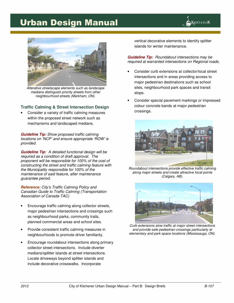
• Encourage roundabout intersections along primary
collector street intersections. Include diverter
medians/splitter islands at street intersections.
Locate driveways beyond splitter islands and
include decorative crosswalks. Incorporate
vertical decorative elements to identify splitter
islands for winter maintenance.
Guideline Tip: Roundabout intersections may be required at warranted intersections on Regional roads.
• Consider curb extensions at collector/local street
intersections and in areas providing access to
major pedestrian destinations such as school
sites, neighbourhood park spaces and transit
stops.
• Consider special pavement markings or impressed
colour concrete bands at major pedestrian
crossings.
Roundabout intersections provide effective traffic calming
along major streets and create attractive focal points (Calgary, AB).
Curb extensions slow traffic at major street intersections
and provide safe pedestrian crossings particularly at elementary and park space locations (Mississauga, ON).
1081081081081081
2012 City of Kitchener Urban Design Manual – Part B: Design Briefs B-108
Urban Design Manual
Special pavement markings such as stamped impressed
concrete patterns distinguish historically significant crossings from other intersections (Kitchener, ON).
Lotting Pattern
• Establish a mix of lot frontages along all street
blocks to promote variety and on-street parking
opportunities. Promote a greater variety of lot
frontages along longer streets. Discourage long
blocks of similar lot frontages.
• Encourage a mixture of lots for different dwelling
types within a neighbourhood and on a street
block. This could include providing semi-detached
lots along streets with townhouse blocks or small
lot frontages.
Guideline Tip: Identify and confirm range of lot widths along streets and blocks through the draft plan and lotting plan, special condition and/or Zoning By-law regulations. Reference: May 29, 2000 Council resolution: “That Council confirm its commitment to mixing lot sizes within subdivisions as set out in the Municipal Plan and direct...to continue to...prepare implement zoning by-laws for Plan of Subdivision respecting this objective where appropriate.”
• Orient and design higher density blocks in close
proximity to transit routes, arterial and collector
streets, planned commercial areas or other
appropriate locations.
• Provide a mix of townhouse block lengths ranging
between 3-6 units per block. Consider longer
blocks to a maximum of 8 units facing window
streets.
• Ensure cluster townhouse development includes
front-facing units along public streets.
• Limit driveway conflicts with transit routes/stops
through the encouragement of multiple dwelling
blocks or private lane-based development along
the route.
• Provide front-facing development along priority
streets and window streets where possible.
• Discourage rear-lotting along arterial streets.
• Encourage small lot frontages in close proximity to
neighbourhood park spaces within walking
distance to planned commercial areas and along
window streets. Discourage small lot frontages on
priority streets and directly across from school
sites. Discourage large concentrations of small
lot frontages.
• Ensure dwelling types and lotting pattern are
designed to conserve and be sensitive to existing
site resources.
• Provide an adequate supply of lots and blocks for
affordable housing.
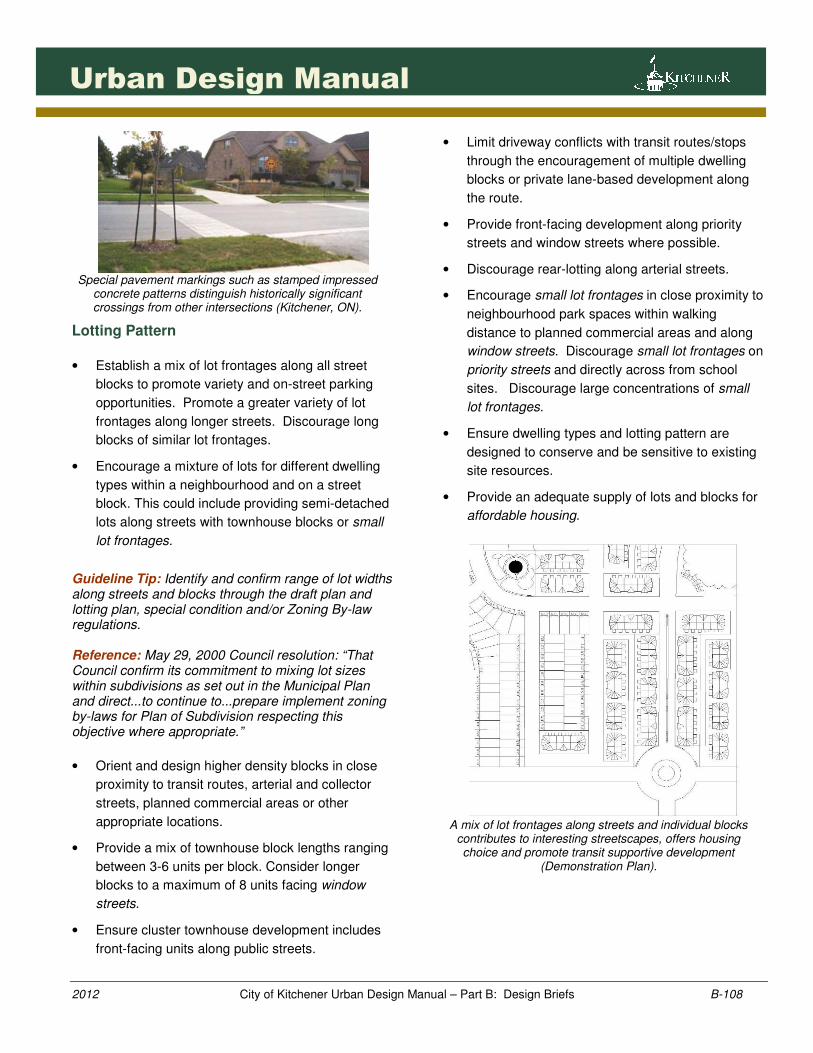
A mix of lot frontages along streets and individual blocks
contributes to interesting streetscapes, offers housing choice and promote transit supportive development
(Demonstration Plan).
1091091091091091
2012 City of Kitchener Urban Design Manual – Part B: Design Briefs B-109
Urban Design Manual
Higher density housing such as three-storey townhouse blocks provides increased density and massing along
arterial streets (Scarborough, ON).
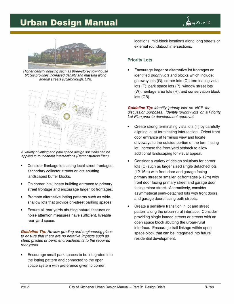
A variety of lotting and park space design solutions can be applied to roundabout intersections (Demonstration Plan).
• Consider flankage lots along local street frontages,
secondary collector streets or lots abutting
landscaped buffer blocks.
• On corner lots, locate building entrance to primary
street frontage and encourage larger lot frontages.
• Promote alternative lotting patterns such as wide-
shallow lots that provide on-street parking spaces.
• Ensure all rear yards abutting natural features or
noise attention measures have sufficient, liveable
rear yard space.
Guideline Tip: Review grading and engineering plans to ensure that there are no netative impacts such as steep grades or berm encroachments to the required rear yards.
• Encourage small park spaces to be integrated into
the lotting pattern and connected to the open
space system with preference given to corner
locations, mid-block locations along long streets or
external roundabout intersections.
Priority Lots
• Encourage larger or alternative lot frontages on
identified priority lots and blocks which include:
gateway lots (G); corner lots (C); terminating vista
lots (T); park space lots (P); window street lots
(W); heritage area lots (H); and conservation block
lots (CB).
Guideline Tip: Identify ‘priority lots’ on ‘NCP’ for discussion purposes. Identify ‘priority lots’ on a Priority Lot Plan prior to development approval.
• Create strong terminating vista lots (T) by carefully
aligning lot at terminating intersection. Orient front
door entrance at terminus view and locate
driveways to the outside portion of the terminating
lot. Increase the front yard setback to allow
additional landscaping for visual appeal.
• Consider a variety of design solutions for corner
lots (C) such as larger sized single detached lots
(12-16m) with front door and garage facing
primary street or smaller lot frontages (<12m) with
front door facing primary street and garage door
facing minor street. Alternatively, consider
asymmetrical semi-detached lots with front doors
and garage doors facing both streets.
• Create a sensitive transition in lot and street
pattern along the urban-rural interface. Consider
providing single loaded streets or streets with an
open space block abutting the urban-rural
interface. Encourage trail linkage within open
space block that can be integrated into future
residential development.
1101101101101101
2012 City of Kitchener Urban Design Manual – Part B: Design Briefs B-110
Urban Design Manual
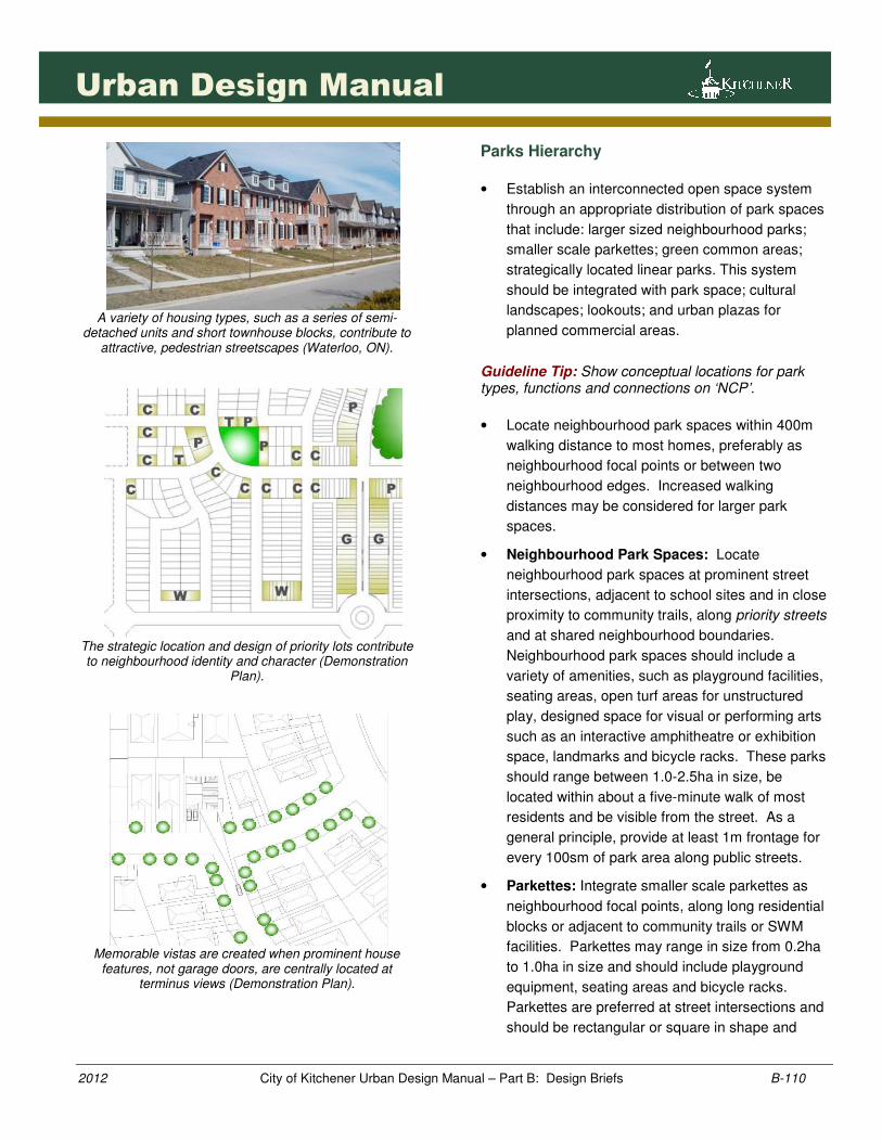
A variety of housing types, such as a series of semi-
detached units and short townhouse blocks, contribute to attractive, pedestrian streetscapes (Waterloo, ON).
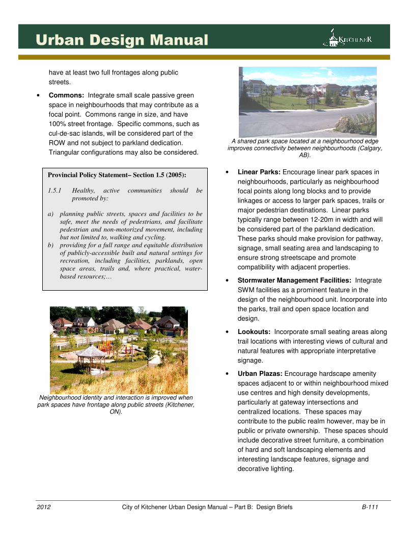
The strategic location and design of priority lots contribute to neighbourhood identity and character (Demonstration
Plan).
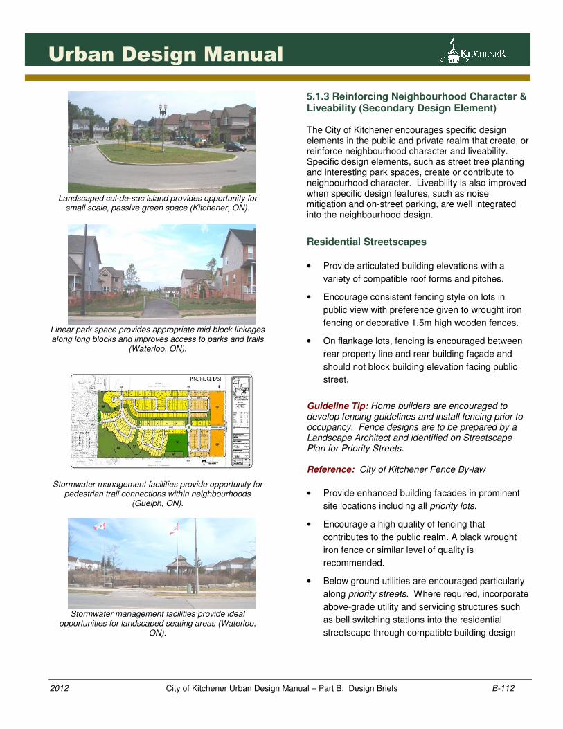
Memorable vistas are created when prominent house
features, not garage doors, are centrally located at terminus views (Demonstration Plan).
Parks Hierarchy
• Establish an interconnected open space system
through an appropriate distribution of park spaces
that include: larger sized neighbourhood parks;
smaller scale parkettes; green common areas;
strategically located linear parks. This system
should be integrated with park space; cultural
landscapes; lookouts; and urban plazas for
planned commercial areas.
Guideline Tip: Show conceptual locations for park types, functions and connections on ‘NCP’.
• Locate neighbourhood park spaces within 400m
walking distance to most homes, preferably as
neighbourhood focal points or between two
neighbourhood edges. Increased walking
distances may be considered for larger park
spaces.
• Neighbourhood Park Spaces: Locate
neighbourhood park spaces at prominent street
intersections, adjacent to school sites and in close
proximity to community trails, along priority streets
and at shared neighbourhood boundaries.
Neighbourhood park spaces should include a
variety of amenities, such as playground facilities,
seating areas, open turf areas for unstructured
play, designed space for visual or performing arts
such as an interactive amphitheatre or exhibition
space, landmarks and bicycle racks. These parks
should range between 1.0-2.5ha in size, be
located within about a five-minute walk of most
residents and be visible from the street. As a
general principle, provide at least 1m frontage for
every 100sm of park area along public streets.
• Parkettes: Integrate smaller scale parkettes as
neighbourhood focal points, along long residential
blocks or adjacent to community trails or SWM
facilities. Parkettes may range in size from 0.2ha
to 1.0ha in size and should include playground
equipment, seating areas and bicycle racks.
Parkettes are preferred at street intersections and
should be rectangular or square in shape and
1111111111111111
2012 City of Kitchener Urban Design Manual – Part B: Design Briefs B-111
Urban Design Manual
have at least two full frontages along public
streets.
• Commons: Integrate small scale passive green
space in neighbourhoods that may contribute as a
focal point. Commons range in size, and have
100% street frontage. Specific commons, such as
cul-de-sac islands, will be considered part of the
ROW and not subject to parkland dedication.
Triangular configurations may also be considered.
Neighbourhood identity and interaction is improved when
park spaces have frontage along public streets (Kitchener, ON).
A shared park space located at a neighbourhood edge
improves connectivity between neighbourhoods (Calgary, AB).
• Linear Parks: Encourage linear park spaces in
neighbourhoods, particularly as neighbourhood
focal points along long blocks and to provide
linkages or access to larger park spaces, trails or
major pedestrian destinations. Linear parks
typically range between 12-20m in width and will
be considered part of the parkland dedication.
These parks should make provision for pathway,
signage, small seating area and landscaping to
ensure strong streetscape and promote
compatibility with adjacent properties.
• Stormwater Management Facilities: Integrate
SWM facilities as a prominent feature in the
design of the neighbourhood unit. Incorporate into
the parks, trail and open space location and
design.
• Lookouts: Incorporate small seating areas along
trail locations with interesting views of cultural and
natural features with appropriate interpretative
signage.
• Urban Plazas: Encourage hardscape amenity
spaces adjacent to or within neighbourhood mixed
use centres and high density developments,
particularly at gateway intersections and
centralized locations. These spaces may
contribute to the public realm however, may be in
public or private ownership. These spaces should
include decorative street furniture, a combination
of hard and soft landscaping elements and
interesting landscape features, signage and
decorative lighting.
Provincial Policy Statement– Section 1.5 (2005):
1.5.1 Healthy, active communities should be
promoted by:
a) planning public streets, spaces and facilities to be
safe, meet the needs of pedestrians, and facilitate
pedestrian and non-motorized movement, including
but not limited to, walking and cycling.
b) providing for a full range and equitable distribution
of publicly-accessible built and natural settings for
recreation, including facilities, parklands, open
space areas, trails and, where practical, water-
based resources;…
1121121121121121
2012 City of Kitchener Urban Design Manual – Part B: Design Briefs B-112
Urban Design Manual
Landscaped cul-de-sac island provides opportunity for
small scale, passive green space (Kitchener, ON).
Linear park space provides appropriate mid-block linkages along long blocks and improves access to parks and trails
(Waterloo, ON).
Stormwater management facilities provide opportunity for
pedestrian trail connections within neighbourhoods (Guelph, ON).
Stormwater management facilities provide ideal
opportunities for landscaped seating areas (Waterloo, ON).
5.1.3 Reinforcing Neighbourhood Character & Liveability (Secondary Design Element) The City of Kitchener encourages specific design elements in the public and private realm that create, or reinforce neighbourhood character and liveability. Specific design elements, such as street tree planting and interesting park spaces, create or contribute to neighbourhood character. Liveability is also improved when specific design features, such as noise mitigation and on-street parking, are well integrated into the neighbourhood design.
Residential Streetscapes
• Provide articulated building elevations with a
variety of compatible roof forms and pitches.
• Encourage consistent fencing style on lots in
public view with preference given to wrought iron
fencing or decorative 1.5m high wooden fences.
• On flankage lots, fencing is encouraged between
rear property line and rear building façade and
should not block building elevation facing public
street.
Guideline Tip: Home builders are encouraged to develop fencing guidelines and install fencing prior to occupancy. Fence designs are to be prepared by a Landscape Architect and identified on Streetscape Plan for Priority Streets. Reference: City of Kitchener Fence By-law
• Provide enhanced building facades in prominent
site locations including all priority lots.
• Encourage a high quality of fencing that
contributes to the public realm. A black wrought
iron fence or similar level of quality is
recommended.
• Below ground utilities are encouraged particularly
along priority streets. Where required, incorporate
above-grade utility and servicing structures such
as bell switching stations into the residential
streetscape through compatible building design
1131131131131131
2012 City of Kitchener Urban Design Manual – Part B: Design Briefs B-113
Urban Design Manual
elements and decorative fencing with intensive
landscaping.
Guideline Tip: Consult utility companies regarding streetscape integration and appropriate building design features.
Attractive, residential streets are created through paired
street tree planting, articulated building massing and architectural variety (Kitchener, ON).
Low-level, decorative fencing provides an acceptable
fencing solution along arterial streets (Mississauga, ON).
Residential streetscapes are enhanced when utility
buildings incorporate similar building materials, rooflines and architectural features such as this telephone switching
station (Kitchener, ON).
Pedestrian Friendly Streets
• Provide subtle variation in building setbacks along
longer street blocks.
Guideline Tip: Considered modified Zoning By-law regulations.
• Encourage flush or partially recessed garages.
Minor garage projections may be considered
subject to providing additional façade elements
that reinforce the street such as porches,
verandas, porticos.
Reference: Zoning By-law, Section 5.
• Promote ‘eyes on the street’ by maximizing
window openings with detailed window treatment
on elevations facing public streets, park spaces
and walkways.
• Ensure that front doors are fully visible from the
public street. Front doors may be recessed from
the building façade subject to providing specific
architectural features such as porches or porticos
that reinforce the entrance and promote activity
along the street.
• Encourage decorative front yard walkway
connection providing unobstructed access from
front door to sidewalk. Encourage different paving
materials such as impressed coloured concrete
and interlocking stone.
1141141141141141
2012 City of Kitchener Urban Design Manual – Part B: Design Briefs B-114
Urban Design Manual
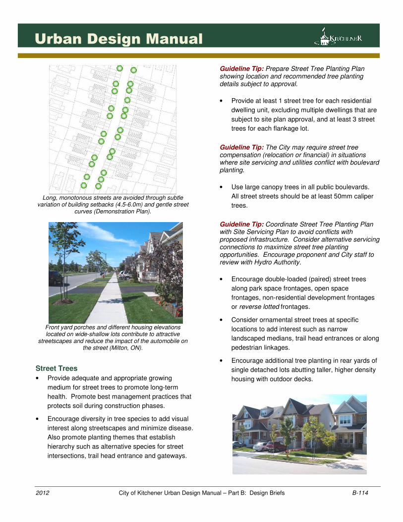
Long, monotonous streets are avoided through subtle
variation of building setbacks (4.5-6.0m) and gentle street curves (Demonstration Plan).
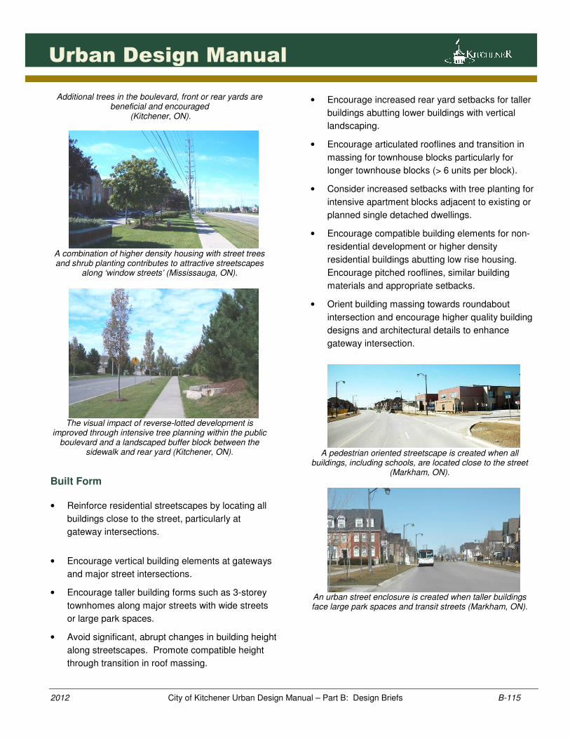
Front yard porches and different housing elevations located on wide-shallow lots contribute to attractive
streetscapes and reduce the impact of the automobile on the street (Milton, ON).
Street Trees
• Provide adequate and appropriate growing
medium for street trees to promote long-term
health. Promote best management practices that
protects soil during construction phases.
• Encourage diversity in tree species to add visual
interest along streetscapes and minimize disease.
Also promote planting themes that establish
hierarchy such as alternative species for street
intersections, trail head entrance and gateways.
Guideline Tip: Prepare Street Tree Planting Plan showing location and recommended tree planting details subject to approval.
• Provide at least 1 street tree for each residential
dwelling unit, excluding multiple dwellings that are
subject to site plan approval, and at least 3 street
trees for each flankage lot.
Guideline Tip: The City may require street tree compensation (relocation or financial) in situations where site servicing and utilities conflict with boulevard planting.
• Use large canopy trees in all public boulevards.
All street streets should be at least 50mm caliper
trees.
Guideline Tip: Coordinate Street Tree Planting Plan with Site Servicing Plan to avoid conflicts with proposed infrastructure. Consider alternative servicing connections to maximize street tree planting opportunities. Encourage proponent and City staff to review with Hydro Authority.
• Encourage double-loaded (paired) street trees
along park space frontages, open space
frontages, non-residential development frontages
or reverse lotted frontages.
• Consider ornamental street trees at specific
locations to add interest such as narrow
landscaped medians, trail head entrances or along
pedestrian linkages.
• Encourage additional tree planting in rear yards of
single detached lots abutting taller, higher density
housing with outdoor decks.
1151151151151151
2012 City of Kitchener Urban Design Manual – Part B: Design Briefs B-115
Urban Design Manual
Additional trees in the boulevard, front or rear yards are beneficial and encouraged
(Kitchener, ON).
A combination of higher density housing with street trees and shrub planting contributes to attractive streetscapes
along ‘window streets’ (Mississauga, ON).
The visual impact of reverse-lotted development is
improved through intensive tree planning within the public boulevard and a landscaped buffer block between the
sidewalk and rear yard (Kitchener, ON).
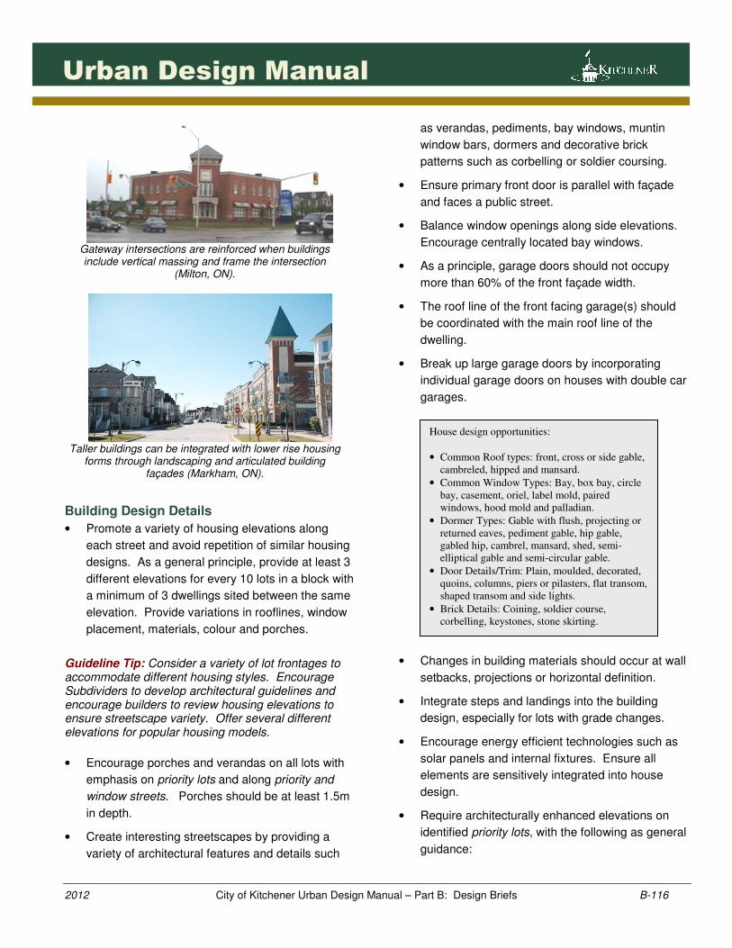
Built Form
• Reinforce residential streetscapes by locating all
buildings close to the street, particularly at
gateway intersections.
• Encourage vertical building elements at gateways
and major street intersections.
• Encourage taller building forms such as 3-storey
townhomes along major streets with wide streets
or large park spaces.
• Avoid significant, abrupt changes in building height
along streetscapes. Promote compatible height
through transition in roof massing.
• Encourage increased rear yard setbacks for taller
buildings abutting lower buildings with vertical
landscaping.
• Encourage articulated rooflines and transition in
massing for townhouse blocks particularly for
longer townhouse blocks (> 6 units per block).
• Consider increased setbacks with tree planting for
intensive apartment blocks adjacent to existing or
planned single detached dwellings.
• Encourage compatible building elements for non-
residential development or higher density
residential buildings abutting low rise housing.
Encourage pitched rooflines, similar building
materials and appropriate setbacks.
• Orient building massing towards roundabout
intersection and encourage higher quality building
designs and architectural details to enhance
gateway intersection.
A pedestrian oriented streetscape is created when all
buildings, including schools, are located close to the street (Markham, ON).
An urban street enclosure is created when taller buildings face large park spaces and transit streets (Markham, ON).
1161161161161161
2012 City of Kitchener Urban Design Manual – Part B: Design Briefs B-116
Urban Design Manual
Gateway intersections are reinforced when buildings include vertical massing and frame the intersection
(Milton, ON).
Taller buildings can be integrated with lower rise housing
forms through landscaping and articulated building façades (Markham, ON).
Building Design Details
• Promote a variety of housing elevations along
each street and avoid repetition of similar housing
designs. As a general principle, provide at least 3
different elevations for every 10 lots in a block with
a minimum of 3 dwellings sited between the same
elevation. Provide variations in rooflines, window
placement, materials, colour and porches.
Guideline Tip: Consider a variety of lot frontages to accommodate different housing styles. Encourage Subdividers to develop architectural guidelines and encourage builders to review housing elevations to ensure streetscape variety. Offer several different elevations for popular housing models.
• Encourage porches and verandas on all lots with
emphasis on priority lots and along priority and
window streets. Porches should be at least 1.5m
in depth.
• Create interesting streetscapes by providing a
variety of architectural features and details such
as verandas, pediments, bay windows, muntin
window bars, dormers and decorative brick
patterns such as corbelling or soldier coursing.
• Ensure primary front door is parallel with façade
and faces a public street.
• Balance window openings along side elevations.
Encourage centrally located bay windows.
• As a principle, garage doors should not occupy
more than 60% of the front façade width.
• The roof line of the front facing garage(s) should
be coordinated with the main roof line of the
dwelling.
• Break up large garage doors by incorporating
individual garage doors on houses with double car
garages.
• Changes in building materials should occur at wall
setbacks, projections or horizontal definition.
• Integrate steps and landings into the building
design, especially for lots with grade changes.
• Encourage energy efficient technologies such as
solar panels and internal fixtures. Ensure all
elements are sensitively integrated into house
design.
• Require architecturally enhanced elevations on
identified priority lots, with the following as general
guidance:
House design opportunities:
• Common Roof types: front, cross or side gable,
cambreled, hipped and mansard.
• Common Window Types: Bay, box bay, circle
bay, casement, oriel, label mold, paired
windows, hood mold and palladian.
• Dormer Types: Gable with flush, projecting or
returned eaves, pediment gable, hip gable,
gabled hip, cambrel, mansard, shed, semi-
elliptical gable and semi-circular gable.
• Door Details/Trim: Plain, moulded, decorated,
quoins, columns, piers or pilasters, flat transom,
shaped transom and side lights.
• Brick Details: Coining, soldier course,
corbelling, keystones, stone skirting.
1171171171171171
2012 City of Kitchener Urban Design Manual – Part B: Design Briefs B-117
Urban Design Manual
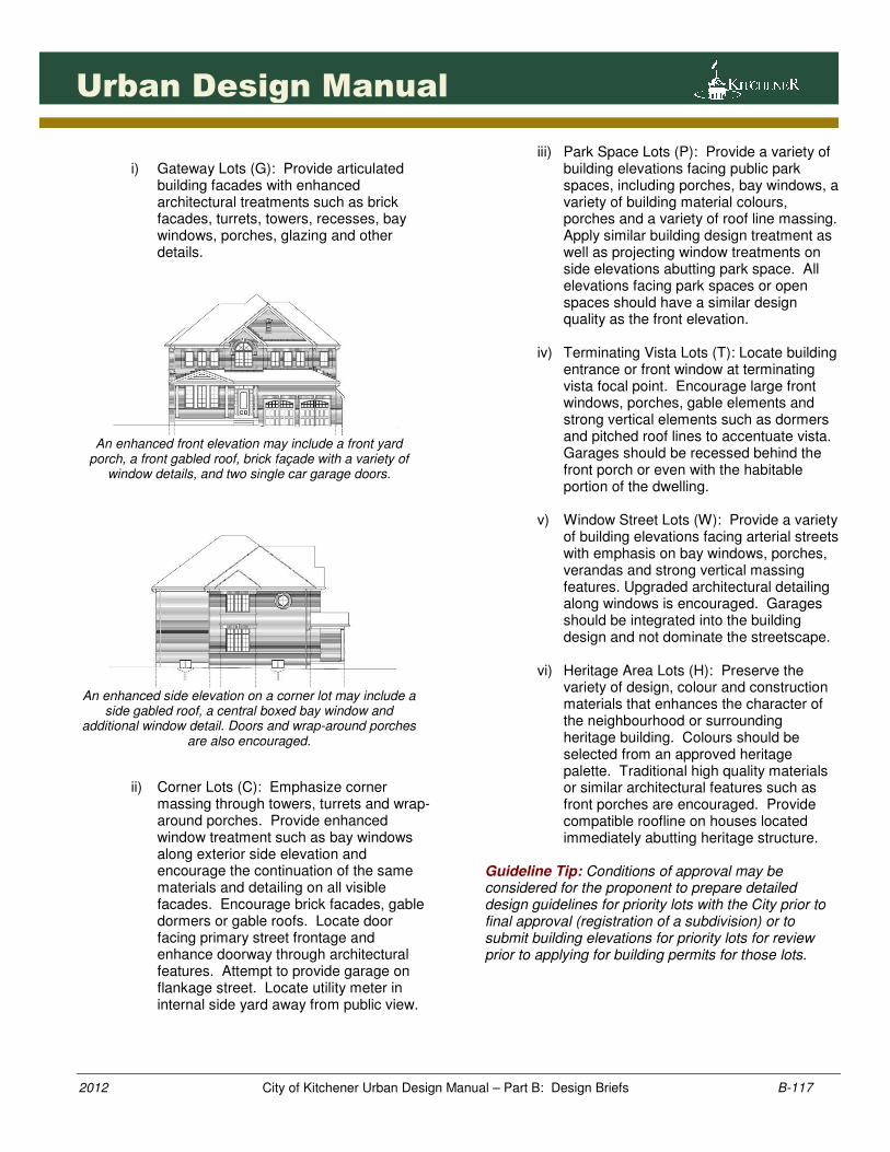
i) Gateway Lots (G): Provide articulated
building facades with enhanced architectural treatments such as brick facades, turrets, towers, recesses, bay windows, porches, glazing and other details.
An enhanced front elevation may include a front yard
porch, a front gabled roof, brick façade with a variety of window details, and two single car garage doors.
An enhanced side elevation on a corner lot may include a
side gabled roof, a central boxed bay window and additional window detail. Doors and wrap-around porches
are also encouraged.
ii) Corner Lots (C): Emphasize corner massing through towers, turrets and wrap-around porches. Provide enhanced window treatment such as bay windows along exterior side elevation and encourage the continuation of the same materials and detailing on all visible facades. Encourage brick facades, gable dormers or gable roofs. Locate door facing primary street frontage and enhance doorway through architectural features. Attempt to provide garage on flankage street. Locate utility meter in internal side yard away from public view.
iii) Park Space Lots (P): Provide a variety of building elevations facing public park spaces, including porches, bay windows, a variety of building material colours, porches and a variety of roof line massing. Apply similar building design treatment as well as projecting window treatments on side elevations abutting park space. All elevations facing park spaces or open spaces should have a similar design quality as the front elevation.
iv) Terminating Vista Lots (T): Locate building
entrance or front window at terminating vista focal point. Encourage large front windows, porches, gable elements and strong vertical elements such as dormers and pitched roof lines to accentuate vista. Garages should be recessed behind the front porch or even with the habitable portion of the dwelling.
v) Window Street Lots (W): Provide a variety
of building elevations facing arterial streets with emphasis on bay windows, porches, verandas and strong vertical massing features. Upgraded architectural detailing along windows is encouraged. Garages should be integrated into the building design and not dominate the streetscape.
vi) Heritage Area Lots (H): Preserve the
variety of design, colour and construction materials that enhances the character of the neighbourhood or surrounding heritage building. Colours should be selected from an approved heritage palette. Traditional high quality materials or similar architectural features such as front porches are encouraged. Provide compatible roofline on houses located immediately abutting heritage structure.
Guideline Tip: Conditions of approval may be considered for the proponent to prepare detailed design guidelines for priority lots with the City prior to final approval (registration of a subdivision) or to submit building elevations for priority lots for review prior to applying for building permits for those lots.
1181181181181181
2012 City of Kitchener Urban Design Manual – Part B: Design Briefs B-118
Urban Design Manual
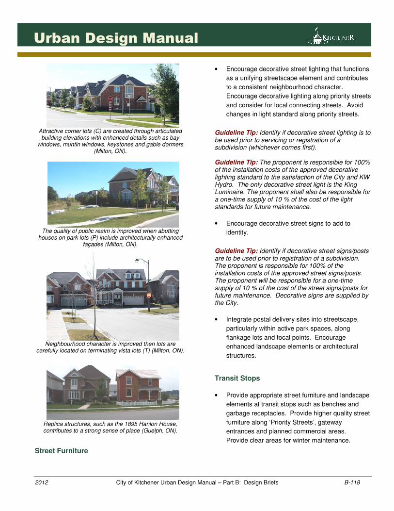
Attractive corner lots (C) are created through articulated building elevations with enhanced details such as bay
windows, muntin windows, keystones and gable dormers (Milton, ON).
The quality of public realm is improved when abutting
houses on park lots (P) include architecturally enhanced façades (Milton, ON).
Neighbourhood character is improved then lots are
carefully located on terminating vista lots (T) (Milton, ON).
Replica structures, such as the 1895 Hanlon House, contributes to a strong sense of place (Guelph, ON).
Street Furniture
• Encourage decorative street lighting that functions
as a unifying streetscape element and contributes
to a consistent neighbourhood character.
Encourage decorative lighting along priority streets
and consider for local connecting streets. Avoid
changes in light standard along priority streets.
Guideline Tip: Identify if decorative street lighting is to be used prior to servicing or registration of a subdivision (whichever comes first). Guideline Tip: The proponent is responsible for 100% of the installation costs of the approved decorative lighting standard to the satisfaction of the City and KW Hydro. The only decorative street light is the King Luminaire. The proponent shall also be responsible for a one-time supply of 10 % of the cost of the light standards for future maintenance.
• Encourage decorative street signs to add to
identity.
Guideline Tip: Identify if decorative street signs/posts are to be used prior to registration of a subdivision. The proponent is responsible for 100% of the installation costs of the approved street signs/posts. The proponent will be responsible for a one-time supply of 10 % of the cost of the street signs/posts for future maintenance. Decorative signs are supplied by the City.
• Integrate postal delivery sites into streetscape,
particularly within active park spaces, along
flankage lots and focal points. Encourage
enhanced landscape elements or architectural
structures.
Transit Stops
• Provide appropriate street furniture and landscape
elements at transit stops such as benches and
garbage receptacles. Provide higher quality street
furniture along ‘Priority Streets’, gateway
entrances and planned commercial areas.
Provide clear areas for winter maintenance.
1191191191191191
2012 City of Kitchener Urban Design Manual – Part B: Design Briefs B-119
Urban Design Manual
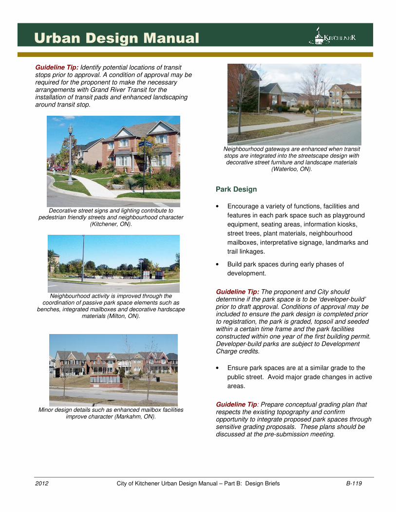
Guideline Tip: Identify potential locations of transit stops prior to approval. A condition of approval may be required for the proponent to make the necessary arrangements with Grand River Transit for the installation of transit pads and enhanced landscaping around transit stop.
Decorative street signs and lighting contribute to
pedestrian friendly streets and neighbourhood character (Kitchener, ON).
Neighbourhood activity is improved through the
coordination of passive park space elements such as benches, integrated mailboxes and decorative hardscape
materials (Milton, ON).
Minor design details such as enhanced mailbox facilities
improve character (Markahm, ON).
Neighbourhood gateways are enhanced when transit stops are integrated into the streetscape design with decorative street furniture and landscape materials
(Waterloo, ON).
Park Design
• Encourage a variety of functions, facilities and
features in each park space such as playground
equipment, seating areas, information kiosks,
street trees, plant materials, neighbourhood
mailboxes, interpretative signage, landmarks and
trail linkages.
• Build park spaces during early phases of
development.
Guideline Tip: The proponent and City should determine if the park space is to be ‘developer-build’ prior to draft approval. Conditions of approval may be included to ensure the park design is completed prior to registration, the park is graded, topsoil and seeded within a certain time frame and the park facilities constructed within one year of the first building permit. Developer-build parks are subject to Development Charge credits.
• Ensure park spaces are at a similar grade to the
public street. Avoid major grade changes in active
areas.
Guideline Tip: Prepare conceptual grading plan that respects the existing topography and confirm opportunity to integrate proposed park spaces through sensitive grading proposals. These plans should be discussed at the pre-submission meeting.
1201201201201201
2012 City of Kitchener Urban Design Manual – Part B: Design Briefs B-120
Urban Design Manual
• Provide enhanced perimeter street tree planting
along street frontage. Encourage double row
street tree planting to reinforce street edge.
• Ensure all park spaces include appropriate
signage visible from surrounding streets.
• Locate playground structures with clear visibility to
public streets.
• Provide a balance of hard and soft landscape
materials at street corners. Encourage a
decorative hardscape surface to accommodate
street furniture such as bike racks, mail boxes and
signage.
• Incorporate seating areas into the play area with
waste and recycling receptacles and trees for
shade. Consider backless benches in areas with
multiple functions and backed benches with areas
of individual focus/activity.
• Encourage architectural structures in active park
spaces associated with other neighbourhood uses.
• Integrate neighbourhood mailboxes into park
spaces. Encourage sheltered facilities in active
park spaces. Do not locate mailboxes within ‘No
Stopping’ zones or along single traffic lanes
abutting median islands.
• Locate bike racks along trails, play areas and park
entrances. Provide hard surfaces under bike rack.
• Provide on-street parking along public streets.
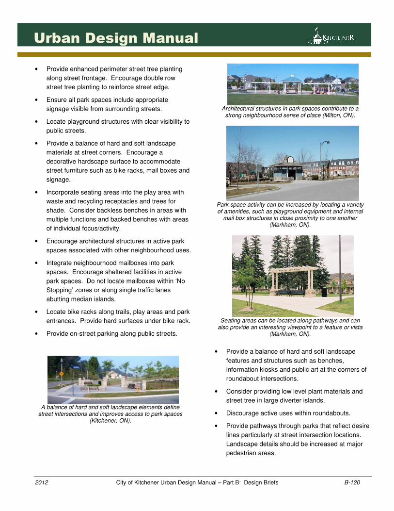
A balance of hard and soft landscape elements define
street intersections and improves access to park spaces (Kitchener, ON).
Architectural structures in park spaces contribute to a
strong neighbourhood sense of place (Milton, ON).
Park space activity can be increased by locating a variety of amenities, such as playground equipment and internal
mail box structures in close proximity to one another (Markham, ON).
Seating areas can be located along pathways and can
also provide an interesting viewpoint to a feature or vista (Markham, ON).
• Provide a balance of hard and soft landscape
features and structures such as benches,
information kiosks and public art at the corners of
roundabout intersections.
• Consider providing low level plant materials and
street tree in large diverter islands.
• Discourage active uses within roundabouts.
• Provide pathways through parks that reflect desire
lines particularly at street intersection locations.
Landscape details should be increased at major
pedestrian areas.
1211211211211211
2012 City of Kitchener Urban Design Manual – Part B: Design Briefs B-121
Urban Design Manual
• Do not located top soil piles on planned park
spaces. Encourage top soil piles to be located on
future development blocks or vacant sites.
Trails & Walkways
• Emphasize connections to the community trail
system for prominent walkways or trailhead
connections through increased trail or walkway
width (9m recommended). Consider special
treatments at trail head entrances such as higher
quality landscape features, benches, decorative
paving pattern, interpretive or directional signage.
Guideline Tip: The trail base should be installed as early in the development process and in accordance with the City’s Subdivision Manual.
• Provide wider trails on hills to accommodate trail
patrons such as the handicapped and elderly.
• Sensitively integrate trails into or adjacent to
natural or open space features.
• At major trail crossings, encourage landscaped
medians. All crossings should be designed for
barrier free access and vehicular lane widths
should be at least 4.0m in width.
• Encourage native plantings along trail connections
abutting natural features.
Guideline Tip: Submit streetscape plan showing recommended plant species for approval.
• Provide sensitive access to scenic drives through
creative or interpretive pedestrian trail linkages or
special pavement markings.
• Recognize historical settlement patterns or routes
through special pedestrian crossings or landscape
elements.
• Design trails so that they are at least 3m from
property lines with opportunity for landscaping.
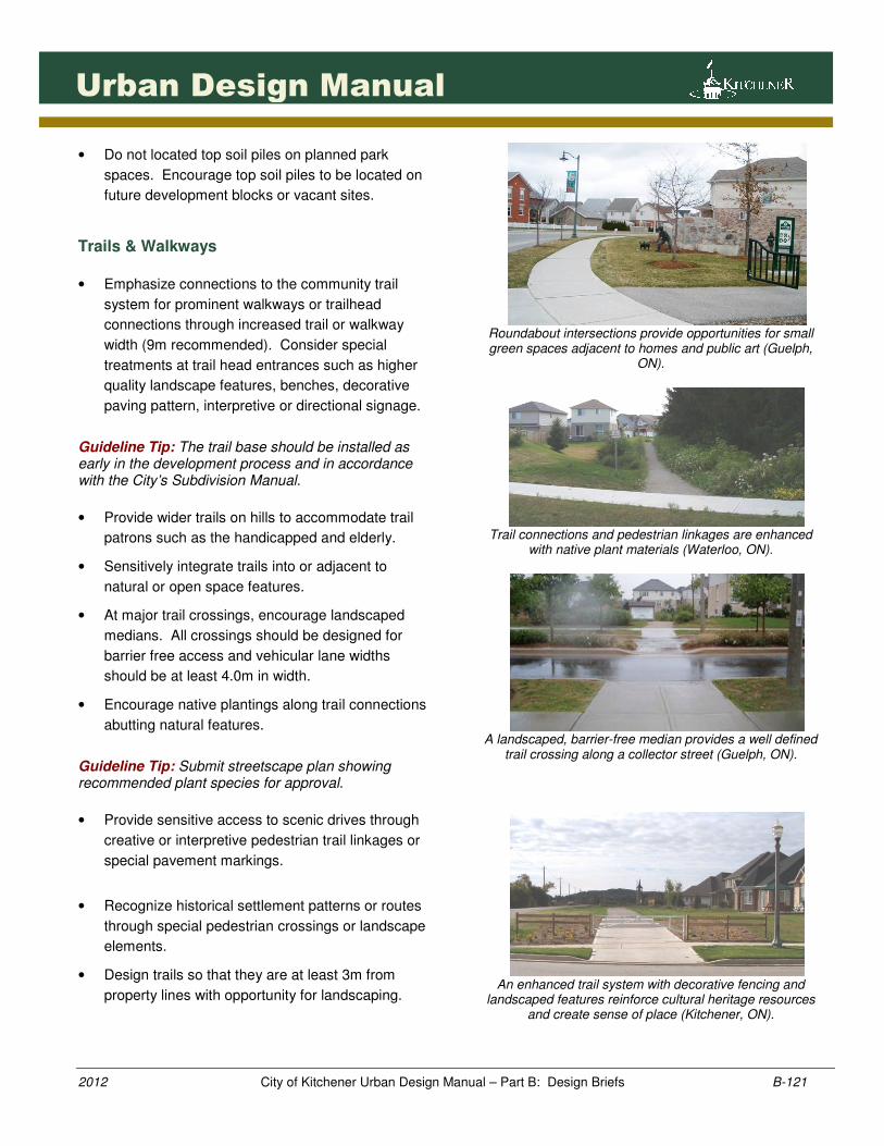
Roundabout intersections provide opportunities for small green spaces adjacent to homes and public art (Guelph,
ON).
Trail connections and pedestrian linkages are enhanced
with native plant materials (Waterloo, ON).
A landscaped, barrier-free median provides a well defined
trail crossing along a collector street (Guelph, ON).
An enhanced trail system with decorative fencing and
landscaped features reinforce cultural heritage resources and create sense of place (Kitchener, ON).
1221221221221221
2012 City of Kitchener Urban Design Manual – Part B: Design Briefs B-122
Urban Design Manual
Cultural Heritage Resources
• Establish appropriate lot width and size to
sensitively integrated cultural heritage resource
into proposed development.
Guideline Tip: Identify preferred lotting plan on ‘NCP’. The integration of existing cultural heritage resources will be subject to an ‘HIA’ for approval.
• Establish a compatible lot pattern and streetscape
for surrounding properties located in close
proximity to the cultural heritage resource.
• Ensure proposed design alterations to cultural
heritage resources are in character with and to
maintain the integrity of existing heritage
resources and their setting.
• Enhance the historic nature of heritage properties
by using appropriately scaled landscaping.
Lighting and fencing should be of a traditional form
and be constructed of appropriate materials.
Reference: The City of Kitchener’s Heritage Inventory List contains a listing of all properties ‘designated’ or ‘of interest’.
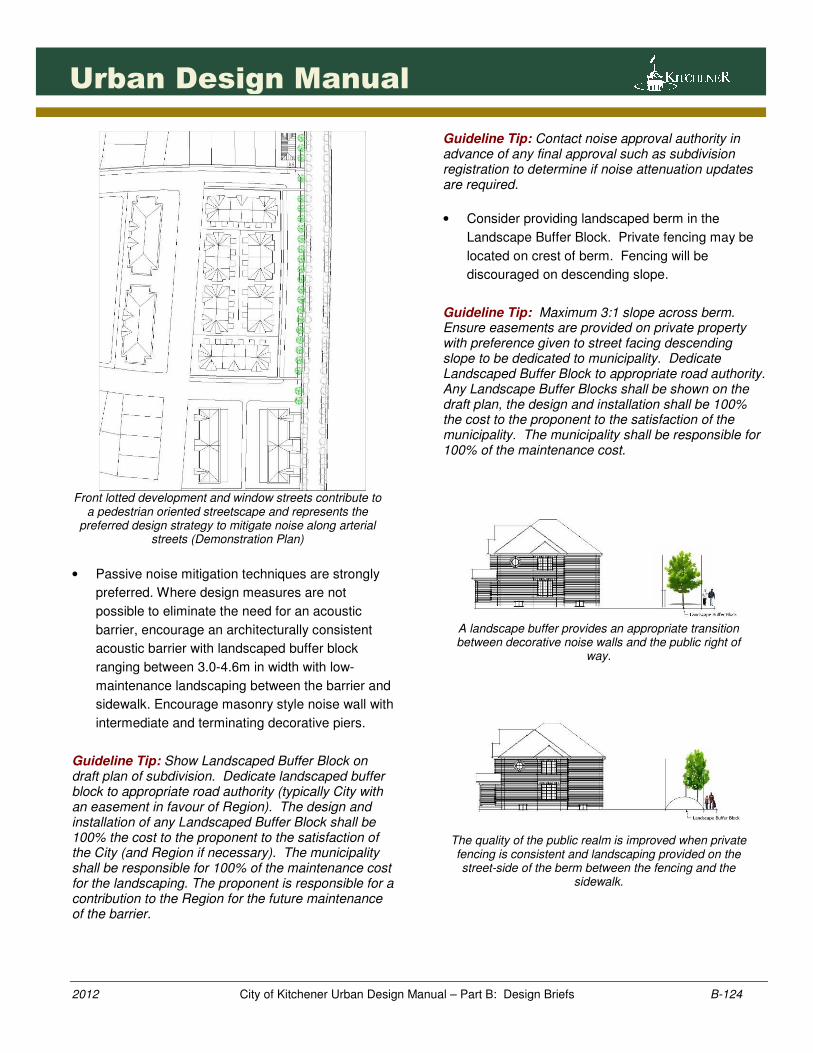
• If heritage buildings are to be relocated, the
preferred relocated sites are lots abutting open
spaces, parks and lots facing open space or on
corner lots.
• Integrate cultural heritage landscapes or park
spaces with existing or relocated heritage
resources. Consider a variety of park space
elements such as interpretive signage, seating
areas and public art. Discourage active park
space elements that may impact heritage
attributes.
Reference: City of Kitchener Culture Plan II
• New buildings should be compatible with cultural
heritage resources. The massing, height, scale,
architectural style and details of new buildings
should complement surrounding heritage
resources.
• Preserve existing road edges where the City
deems appropriate. Consider avoiding sidewalks
or curbs along either side of the road where such
features negatively impact the historical character
of the area.
• Retain and integrate existing lanes, driveways or
linkages where appropriate. Consider a variety of
surface materials or integrated trail system that
preserve or enhance the heritage character of the
area.
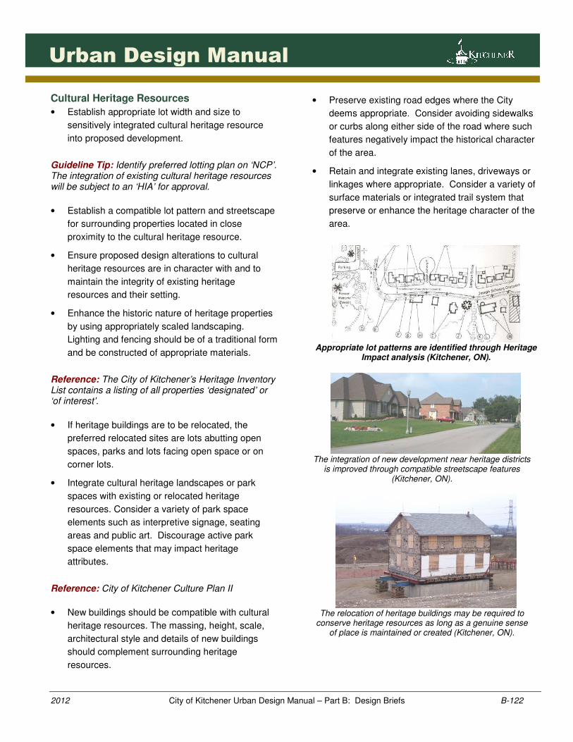
Appropriate lot patterns are identified through Heritage
Impact analysis (Kitchener, ON).
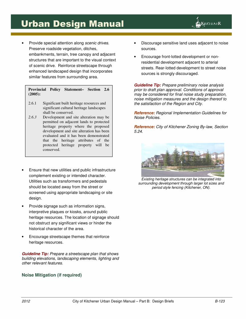
The integration of new development near heritage districts
is improved through compatible streetscape features (Kitchener, ON).
The relocation of heritage buildings may be required to
conserve heritage resources as long as a genuine sense of place is maintained or created (Kitchener, ON).
1231231231231231
2012 City of Kitchener Urban Design Manual – Part B: Design Briefs B-123
Urban Design Manual
• Provide special attention along scenic drives.
Preserve roadside vegetation, ditches,
embankments, terrain, tree canopy and adjacent
structures that are important to the visual context
of scenic drive. Reinforce streetscape through
enhanced landscaped design that incorporates
similar features from surrounding area.
• Ensure that new utilities and public infrastructure
complement existing or intended character.
Utilities such as transformers and pedestals
should be located away from the street or
screened using appropriate landscaping or site
design.
• Provide signage such as information signs,
interpretive plaques or kiosks, around public
heritage resources. The location of signage should
not obstruct any significant views or hinder the
historical character of the area.
• Encourage streetscape themes that reinforce
heritage resources.
Guideline Tip: Prepare a streetscape plan that shows building elevations, landscaping elements, lighting and other relevant features.
Noise Mitigation (if required)
• Discourage sensitive land uses adjacent to noise
sources.
• Encourage front-lotted development or non-
residential development adjacent to arterial
streets. Rear-lotted development to street noise
sources is strongly discouraged.
Guideline Tip: Prepare preliminary noise analysis prior to draft plan approval. Conditions of approval may be considered for final noise study preparation, noise mitigation measures and the design thereof to the satisfaction of the Region and City. Reference: Regional Implementation Guidelines for Noise Policies. Reference: City of Kitchener Zoning By-law, Section 5.24.
Existing heritage structures can be integrated into
surrounding development through larger lot sizes and period style fencing (Kitchener, ON).
Provincial Policy Statement– Section 2.6
(2005):
2.6.1 Significant built heritage resources and
significant cultural heritage landscapes
shall be conserved.
2.6.3 Development and site alteration may be
permitted on adjacent lands to protected
heritage property where the proposed
development and site alteration has been
evaluated and it has been demonstrated
that the heritage attributes of the
protected heritage property will be
conserved.
1241241241241241
2012 City of Kitchener Urban Design Manual – Part B: Design Briefs B-124
Urban Design Manual
Front lotted development and window streets contribute to
a pedestrian oriented streetscape and represents the preferred design strategy to mitigate noise along arterial
streets (Demonstration Plan)
• Passive noise mitigation techniques are strongly
preferred. Where design measures are not
possible to eliminate the need for an acoustic
barrier, encourage an architecturally consistent
acoustic barrier with landscaped buffer block
ranging between 3.0-4.6m in width with low-
maintenance landscaping between the barrier and
sidewalk. Encourage masonry style noise wall with
intermediate and terminating decorative piers.
Guideline Tip: Show Landscaped Buffer Block on draft plan of subdivision. Dedicate landscaped buffer block to appropriate road authority (typically City with an easement in favour of Region). The design and installation of any Landscaped Buffer Block shall be 100% the cost to the proponent to the satisfaction of the City (and Region if necessary). The municipality shall be responsible for 100% of the maintenance cost for the landscaping. The proponent is responsible for a contribution to the Region for the future maintenance of the barrier.
Guideline Tip: Contact noise approval authority in advance of any final approval such as subdivision registration to determine if noise attenuation updates are required.
• Consider providing landscaped berm in the
Landscape Buffer Block. Private fencing may be
located on crest of berm. Fencing will be
discouraged on descending slope.
Guideline Tip: Maximum 3:1 slope across berm. Ensure easements are provided on private property with preference given to street facing descending slope to be dedicated to municipality. Dedicate Landscaped Buffer Block to appropriate road authority. Any Landscape Buffer Blocks shall be shown on the draft plan, the design and installation shall be 100% the cost to the proponent to the satisfaction of the municipality. The municipality shall be responsible for 100% of the maintenance cost.
A landscape buffer provides an appropriate transition between decorative noise walls and the public right of
way.
The quality of the public realm is improved when private fencing is consistent and landscaping provided on the street-side of the berm between the fencing and the
sidewalk.
1251251251251251
2012 City of Kitchener Urban Design Manual – Part B: Design Briefs B-125
Urban Design Manual
On-Street Parking
• Provide 1 on-street parking space for every 2-
single detached dwelling units. On-street parking
spaces should be provided on the same street as,
or, along the flankage of the houses that require
the space.
Guideline Tip: Each on-street parking space shall be in accordance with the City’s parking standards (including 1.5m clearance at front and end of stall(s)). Prepare an on-street parking plan and preliminary driveway location plan along with the site servicing engineering drawings. The final lotting plan should achieve the creation of an adequate supply of parking. Reference: City’s On-Street Parking Policy
• Locate on-street parking spaces at least 9.0
metres from street intersection to ensure adequate
visibility.
• Encourage lotting patterns that accommodate on-
street parking such as larger single detached lots
(≥11 metres), condominium lane-based
townhouses, apartment blocks and detached rear
yard garage lots.
• Encourage shorter blocks with flankage lots to
accommodate on-street parking spaces
particularly for small lot frontages.
• Discourage continuous rows of small frontage lots.
Provide shorter block lengths to accommodate on-
street parking needs along side yard flankage.
• Provide on-street parking along large park
frontages or open space street frontages.
• Encourage shorter blocks of townhouse units (3-4
units) on collector streets.
• Consider minor widening to driveway curb opening
however, prohibit widenings that substantially
increase curb opening or eliminate on-street
parking spaces.
• Allow driveways to be widened into the closest
side yard provided that the resulting side yard is
not less than 2 feet and the garage width is less
than a double car garage.
• Consider integrating parking spaces in landscaped
cul-de-sac islands. Orient landscaped islands
facing public street and incorporate street trees
and other complementary landscaping materials.
• Consider developing an off-street, condominium
parking lot, to meet the visitor parking
requirements.
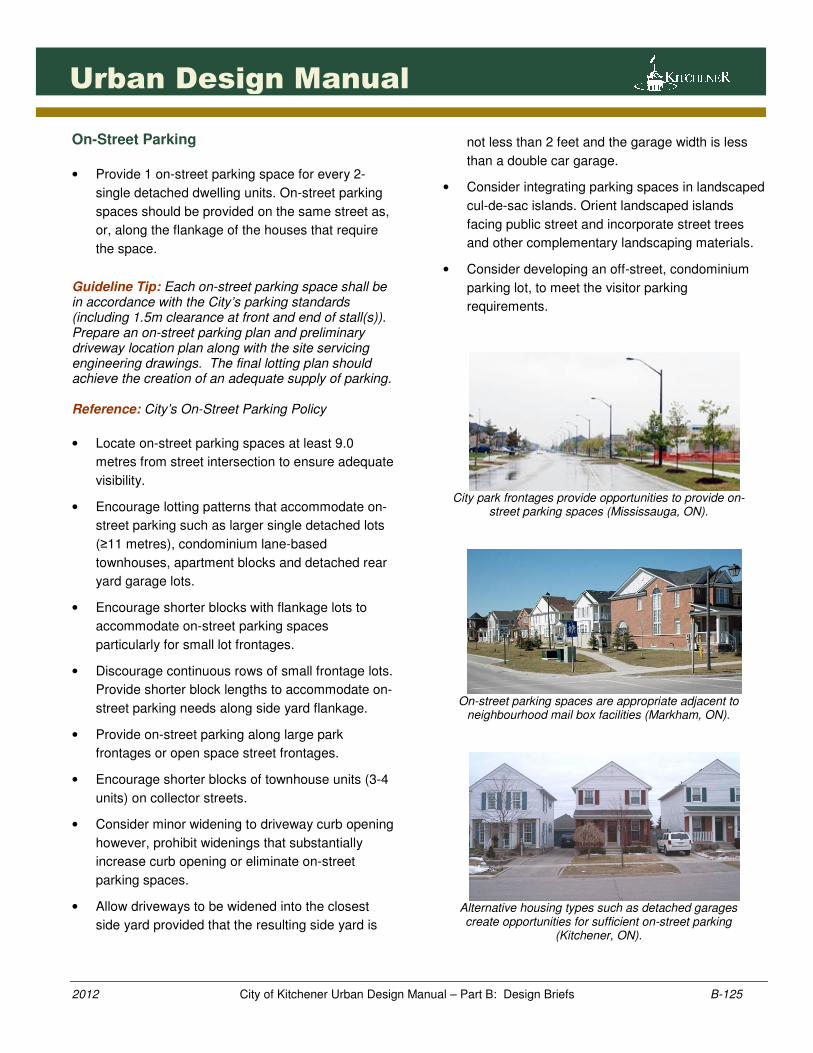
City park frontages provide opportunities to provide on-
street parking spaces (Mississauga, ON).
On-street parking spaces are appropriate adjacent to
neighbourhood mail box facilities (Markham, ON).
Alternative housing types such as detached garages create opportunities for sufficient on-street parking
(Kitchener, ON).
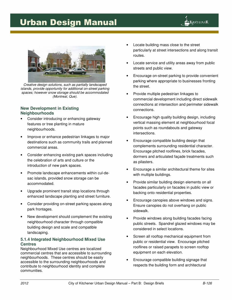
1261261261261261
2012 City of Kitchener Urban Design Manual – Part B: Design Briefs B-126
Urban Design Manual
Creative design solutions, such as partially landscaped
islands, provide opportunity for additional on-street parking spaces; however snow storage should be accommodated
(Montreal, Que).
New Development in Existing Neighbourhoods
• Consider introducing or enhancing gateway
features or tree planting in mature
neighbourhoods.
• Improve or enhance pedestrian linkages to major
destinations such as community trails and planned
commercial areas.
• Consider enhancing existing park spaces including
the celebration of arts and culture or the
introduction of new park spaces.
• Promote landscape enhancements within cul-de-
sac islands, provided snow storage can be
accommodated.
• Upgrade prominent transit stop locations through
enhanced landscape planting and street furniture.
• Consider providing on-street parking spaces along
park frontages.
• New development should complement the existing
neighbourhood character through compatible
building design and scale and compatible
landscaping.
5.1.4 Integrated Neighbourhood Mixed Use Centres Neighbourhood Mixed Use centres are localized commercial centres that are accessible to surrounding neighbourhoods. These centres should be easily accessible to the surrounding neighbourhoods and contribute to neighbourhood identity and complete communities.
• Locate building mass close to the street
particularly at street intersections and along transit
routes.
• Locate service and utility areas away from public
streets and public view.
• Encourage on-street parking to provide convenient
parking where appropriate to businesses fronting
the street.
• Provide multiple pedestrian linkages to
commercial development including direct sidewalk
connections at intersection and perimeter sidewalk
connections.
• Encourage high quality building design, including
vertical massing element at neighbourhood focal
points such as roundabouts and gateway
intersections.
• Encourage compatible building design that
complements surrounding residential character.
Encourage pitched rooflines, brick facades,
dormers and articulated façade treatments such
as pilasters.
• Encourage a similar architectural theme for sites
with multiple buildings.
• Provide similar building design elements on all
facades particularly on facades in public view or
backing onto residential properties.
• Encourage canopies above windows and signs.
Ensure canopies do not overhang on public
sidewalk.
• Provide windows along building facades facing
public streets. Spandrel glazed windows may be
considered in select locations.
• Screen all rooftop mechanical equipment from
public or residential view. Encourage pitched
rooflines or raised parapets to screen rooftop
equipment on each elevation.
• Encourage compatible building signage that
respects the building form and architectural
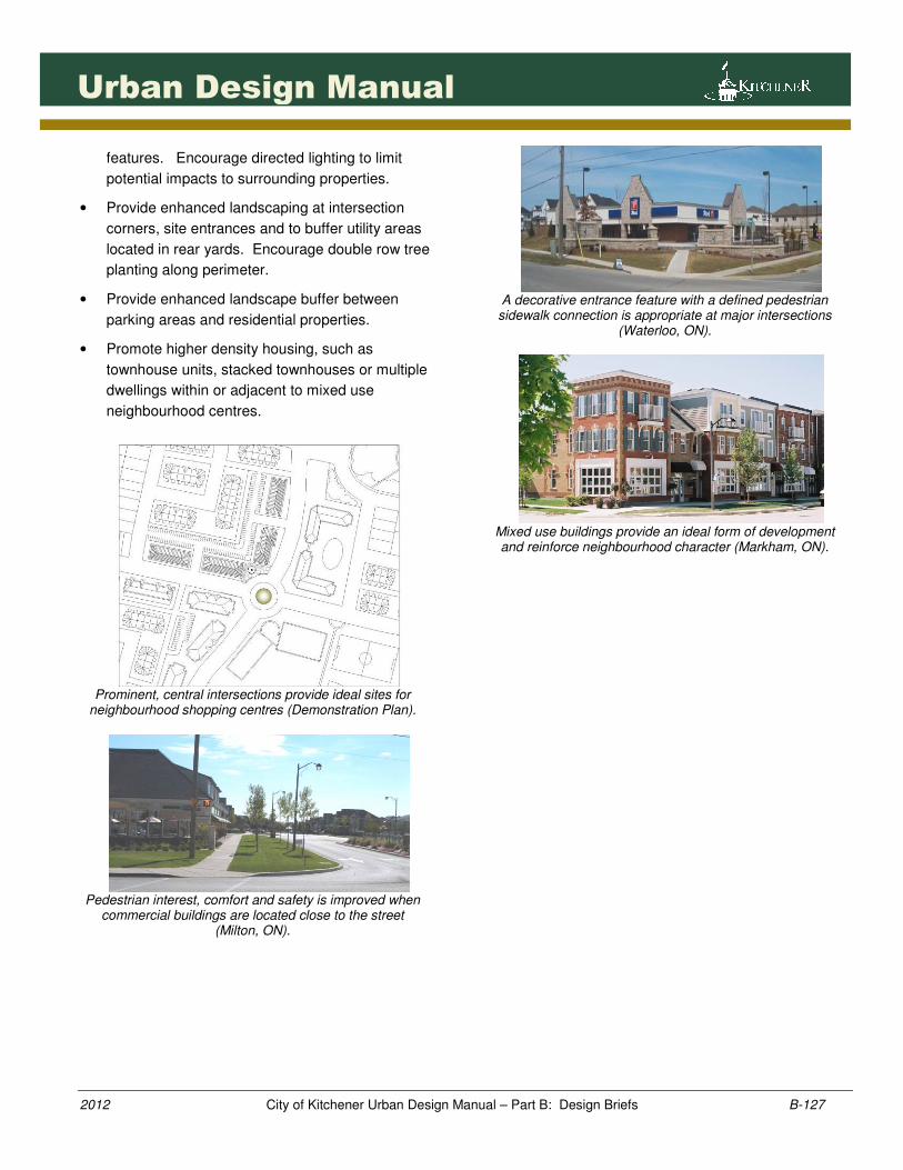
1271271271271271
2012 City of Kitchener Urban Design Manual – Part B: Design Briefs B-127
Urban Design Manual
features. Encourage directed lighting to limit
potential impacts to surrounding properties.
• Provide enhanced landscaping at intersection
corners, site entrances and to buffer utility areas
located in rear yards. Encourage double row tree
planting along perimeter.
• Provide enhanced landscape buffer between
parking areas and residential properties.
• Promote higher density housing, such as
townhouse units, stacked townhouses or multiple
dwellings within or adjacent to mixed use
neighbourhood centres.
Prominent, central intersections provide ideal sites for
neighbourhood shopping centres (Demonstration Plan).
Pedestrian interest, comfort and safety is improved when
commercial buildings are located close to the street (Milton, ON).
A decorative entrance feature with a defined pedestrian
sidewalk connection is appropriate at major intersections (Waterloo, ON).
Mixed use buildings provide an ideal form of development and reinforce neighbourhood character (Markham, ON).
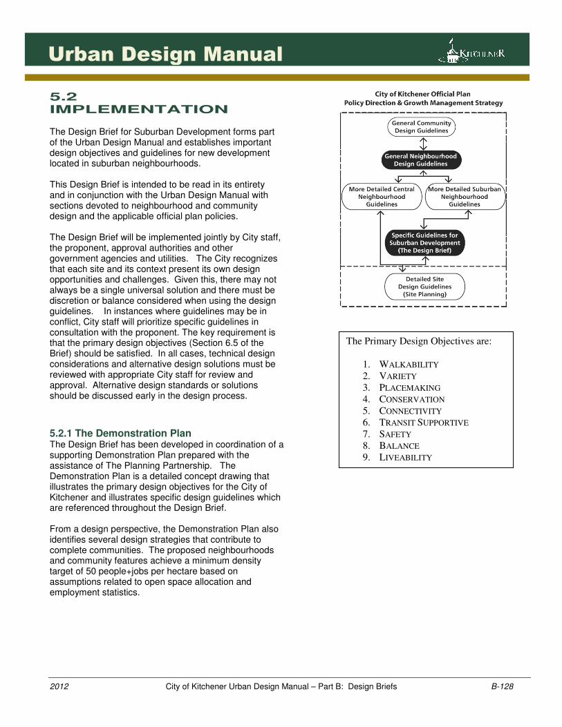
1281281281281281
2012 City of Kitchener Urban Design Manual – Part B: Design Briefs B-128
Urban Design Manual
5.2 IMPLEMENTATION The Design Brief for Suburban Development forms part of the Urban Design Manual and establishes important design objectives and guidelines for new development located in suburban neighbourhoods. This Design Brief is intended to be read in its entirety and in conjunction with the Urban Design Manual with sections devoted to neighbourhood and community design and the applicable official plan policies. The Design Brief will be implemented jointly by City staff, the proponent, approval authorities and other government agencies and utilities. The City recognizes that each site and its context present its own design opportunities and challenges. Given this, there may not always be a single universal solution and there must be discretion or balance considered when using the design guidelines. In instances where guidelines may be in conflict, City staff will prioritize specific guidelines in consultation with the proponent. The key requirement is that the primary design objectives (Section 6.5 of the Brief) should be satisfied. In all cases, technical design considerations and alternative design solutions must be reviewed with appropriate City staff for review and approval. Alternative design standards or solutions should be discussed early in the design process.
5.2.1 The Demonstration Plan The Design Brief has been developed in coordination of a supporting Demonstration Plan prepared with the assistance of The Planning Partnership. The Demonstration Plan is a detailed concept drawing that illustrates the primary design objectives for the City of Kitchener and illustrates specific design guidelines which are referenced throughout the Design Brief. From a design perspective, the Demonstration Plan also identifies several design strategies that contribute to complete communities. The proposed neighbourhoods and community features achieve a minimum density target of 50 people+jobs per hectare based on assumptions related to open space allocation and employment statistics.
The Primary Design Objectives are:
1. WALKABILITY
2. VARIETY
3. PLACEMAKING
4. CONSERVATION
5. CONNECTIVITY
6. TRANSIT SUPPORTIVE
7. SAFETY
8. BALANCE
9. LIVEABILITY
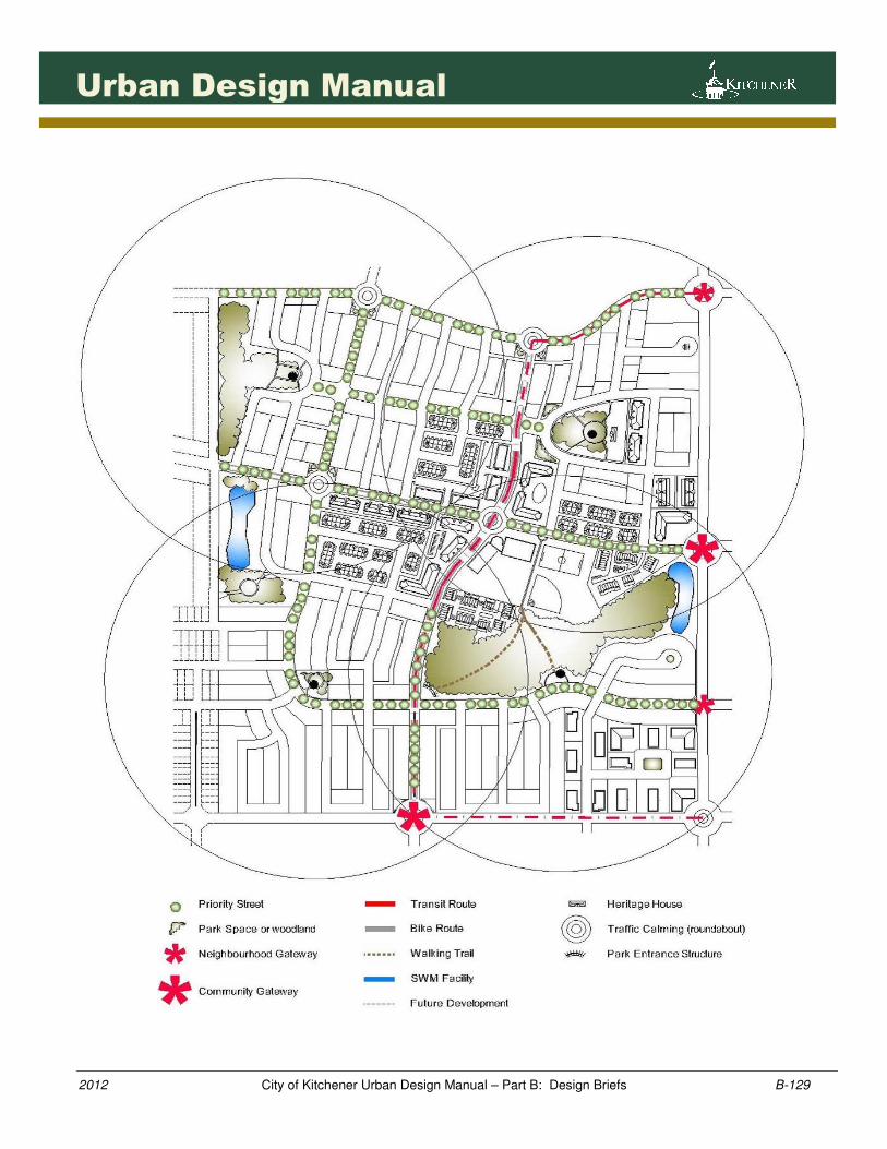
1291291291291291
2012 City of Kitchener Urban Design Manual – Part B: Design Briefs B-129
Urban Design Manual
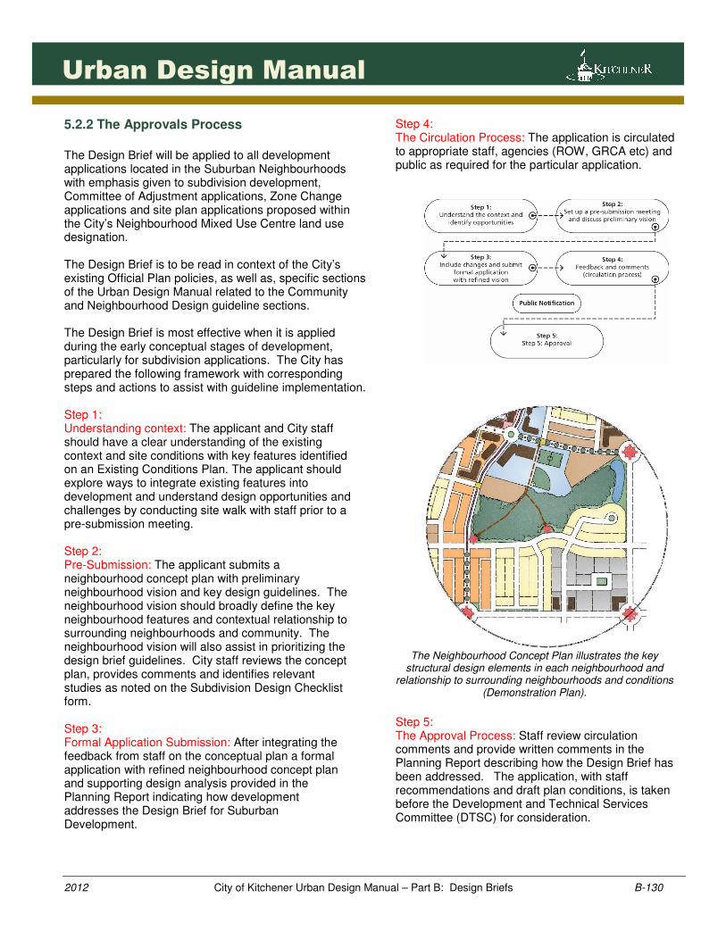
1301301301301301
2012 City of Kitchener Urban Design Manual – Part B: Design Briefs B-130
Urban Design Manual
5.2.2 The Approvals Process
The Design Brief will be applied to all development applications located in the Suburban Neighbourhoods with emphasis given to subdivision development, Committee of Adjustment applications, Zone Change applications and site plan applications proposed within the City’s Neighbourhood Mixed Use Centre land use designation. The Design Brief is to be read in context of the City’s existing Official Plan policies, as well as, specific sections of the Urban Design Manual related to the Community and Neighbourhood Design guideline sections. The Design Brief is most effective when it is applied during the early conceptual stages of development, particularly for subdivision applications. The City has prepared the following framework with corresponding steps and actions to assist with guideline implementation. Step 1: Understanding context: The applicant and City staff should have a clear understanding of the existing context and site conditions with key features identified on an Existing Conditions Plan. The applicant should explore ways to integrate existing features into development and understand design opportunities and challenges by conducting site walk with staff prior to a pre-submission meeting. Step 2: Pre-Submission: The applicant submits a neighbourhood concept plan with preliminary neighbourhood vision and key design guidelines. The neighbourhood vision should broadly define the key neighbourhood features and contextual relationship to surrounding neighbourhoods and community. The neighbourhood vision will also assist in prioritizing the design brief guidelines. City staff reviews the concept plan, provides comments and identifies relevant studies as noted on the Subdivision Design Checklist form. Step 3: Formal Application Submission: After integrating the feedback from staff on the conceptual plan a formal application with refined neighbourhood concept plan and supporting design analysis provided in the Planning Report indicating how development addresses the Design Brief for Suburban Development.
Step 4: The Circulation Process: The application is circulated to appropriate staff, agencies (ROW, GRCA etc) and public as required for the particular application.
The Neighbourhood Concept Plan illustrates the key
structural design elements in each neighbourhood and relationship to surrounding neighbourhoods and conditions
(Demonstration Plan).
Step 5: The Approval Process: Staff review circulation comments and provide written comments in the Planning Report describing how the Design Brief has been addressed. The application, with staff recommendations and draft plan conditions, is taken before the Development and Technical Services Committee (DTSC) for consideration.
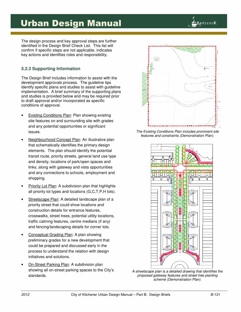
1311311311311311
2012 City of Kitchener Urban Design Manual – Part B: Design Briefs B-131
Urban Design Manual
The design process and key approval steps are further identified in the Design Brief Check List. This list will confirm if specific steps are not applicable, indicates key actions and identifies roles and responsibility.
5.2.3 Supporting Information The Design Brief includes information to assist with the development approvals process. The guideline tips identify specific plans and studies to assist with guideline implementation. A brief summary of the supporting plans and studies is provided below and may be required prior to draft approval and/or incorporated as specific conditions of approval.
• Existing Conditions Plan: Plan showing existing
site features on and surrounding site with grades
and any potential opportunities or significant
issues.
• Neighbourhood Concept Plan: An illustrative plan
that schematically identifies the primary design
elements. The plan should identify the potential
transit route, priority streets, general land use type
and density, locations of park/open spaces and
links, along with gateway and vista opportunities
and any connections to schools, employment and
shopping.
• Priority Lot Plan: A subdivision plan that highlights
all priority lot types and locations (G,C,T,P,H lots).
• Streetscape Plan: A detailed landscape plan of a
priority street that could show locations and
construction details for entrance features,
crosswalks, street trees, potential utility locations,
traffic calming features, centre medians (if any)
and fencing/landscaping details for corner lots.
• Conceptual Grading Plan: A plan showing
preliminary grades for a new development that
could be prepared and discussed early in the
process to understand the relation with design
initiatives and solutions.
• On-Street Parking Plan: A subdivision plan
showing all on-street parking spaces to the City’s
standards.
The Existing Conditions Plan includes prominent site
features and constraints (Demonstration Plan).
A streetscape plan is a detailed drawing that identifies the
proposed gateway features and street tree planting scheme (Demonstration Plan).
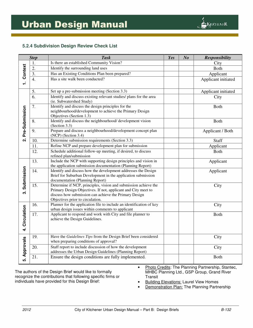
1321321321321321
2012 City of Kitchener Urban Design Manual – Part B: Design Briefs B-132
Urban Design Manual
5.2.4 Subdivision Design Review Check List
Step Task Yes No Responsibility
1. C
on
text 1. Is there an established Community Vision? City
2. Identify the surrounding land uses Both
3. Has an Existing Conditions Plan been prepared? Applicant
4. Has a site walk been conducted? Applicant initiated
2. P
re-S
ub
mis
sio
n
5. Set up a pre-submission meeting (Section 3.3) Applicant initiated
6. Identify and discuss existing relevant studies/ plans for the area
(ie. Subwatershed Study) City
7. Identify and discuss the design principles for the
neighbourhood/development to achieve the Primary Design
Objectives (Section 1.3)
Both
8. Identify and discuss the neighbourhood/ development vision
(Section 3.3) Both
9. Prepare and discuss a neighbourhood/development concept plan
(NCP) (Section 3.4) Applicant / Both
10. Determine submission requirements (Section 3.3) Staff
11. Refine NCP and prepare development plan for submission Applicant
12. Schedule additional follow-up meeting, if desired, to discuss
refined plan/submission Both
3. S
ub
mis
sio
n
13. Include the NCP with supporting design principles and vision in
the application submission documentation (Planning Report) Applicant
14. Identify and discuss how the development addresses the Design
Brief for Suburban Development in the application submission
documentation (Planning Report)
Applicant
15. Determine if NCP, principles, vision and submission achieve the
Primary Design Objectives. If not, applicant and City meet to
discuss how submission can achieve the Primary Design
Objectives prior to circulation.
City
4. C
ircu
lati
on
16. Planner for the application file to include an identification of key
urban design issues within comments to applicant City
17. Applicant to respond and work with City and file planner to
achieve the Design Guidelines. Both
5. A
pp
rov
als
19. Have the Guidelines Tips from the Design Brief been considered
when preparing conditions of approval? City
20. Staff report to include discussion of how the development
addresses the Urban Design Guidelines (Planning Report) City
21. Ensure the design conditions are fully implemented. Both
The authors of the Design Brief would like to formally recognize the contributions that following specific firms or individuals have provided for this Design Brief:
• Photo Credits: The Planning Partnership, Stantec, MHBC Planning Ltd., GSP Group, Grand River Transit
• Building Elevations: Laurel View Homes
• Demonstration Plan: The Planning Partnership
2012 City of Kitchener Urban Design Manual – Part B: Design Briefs B-133
Urban Design Manual
5.2.5 Glossary of Terms For the purpose of this Design Brief, the following definitions have been included for reference purposes and implementation:
• AADT (Average Annual Daily Traffic): The total
volume of vehicle traffic in both directions of a
road for a year divided by 365 days. Useful
measurement of how busy the road is.
• Affordable Housing: “is housing that is
affordable to low and moderate income
households” (Region of Waterloo, A Community
Action Plan for Housing).
• Built Heritage Resources: “one or more
significant buildings, structures, monuments,
installations or remains associated with
architectural, cultural, social, political, economic or
military history and identified as being important to
a community. These resources may be identified
through designation or heritage conservation
easement under the Ontario Heritage Act, or listed
by local, provincial or federal jurisdictions.” (PPS,
2005)
• Conserved “the identification, protection, use
and/or management of cultural heritage and
archaeological resources in such a way that their
heritage values, attributes and integrity are
retained. This may be addressed through a
conservation plan or HIA.” (PPS, 2005):
• Cultural Heritage Landscape: “a defined
geographical area of heritage significance which
has been modified by human activities and is
valued by a community. It involves a grouping(s)
of individual heritage features such as structures,
spaces, archaeological sites and natural elements,
which together form a significant type of heritage
form, distinctive from that of its constituent
elements or parts. Examples may include, but are
not limited to, heritage conservation districts
designated under the Ontario Heritage Act; and
villages, parks, gardens, battlefields, mainstreets
and neighbourhoods, cemeteries, trailways and
industrial complexes of cultural heritage value.”
(PPS, 2005)
• Complete Communities: “Complete communities
meet people’s needs for daily living throughout an
entire lifetime by providing convenient access to
an appropriate mix of jobs, local services, a full
range of housing, and community infrastructure
including affordable housing, schools, recreation
and open space for their residents. Convenient
access to public transportation and options for
safe, non-motorized travel is also provided.”
(Places to Grow, 2006)
• Designated Greenfield Area: “The area within a
settlement area that is not built-up area. Where a
settlement area does not have a built boundary,
the entire settlement area is considered
designated greenfield area.” (Places to Grow,
2006)
• EIS (Environmental Impact Study): A study
conducted prior to development to investigate
potential environmental impacts of the proposed
undertaking. An EIS will determine whether
development may proceed, and if so, will identify
action s which could be taken in order of
preference to prevent, minimize or mitigate the
environmental impacts of the development (City of
Kitchener Municipal Plan).
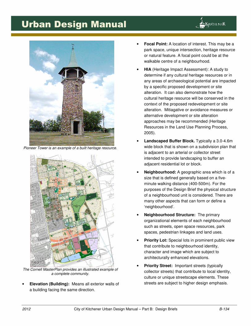
2012 City of Kitchener Urban Design Manual – Part B: Design Briefs B-134
Urban Design Manual
Pioneer Tower is an example of a built heritage resource.
The Cornell MasterPlan provides an illustrated example of
a complete community.
• Elevation (Building): Means all exterior walls of
a building facing the same direction.
• Focal Point: A location of interest. This may be a
park space, unique intersection, heritage resource
or natural feature. A focal point could be at the
walkable centre of a neighbourhood.
• HIA (Heritage Impact Assessment): A study to
determine if any cultural heritage resources or in
any areas of archaeological potential are impacted
by a specific proposed development or site
alteration. It can also demonstrate how the
cultural heritage resource will be conserved in the
context of the proposed redevelopment or site
alteration. Mitiagative or avoidance measures or
alternative development or site alteration
approaches may be recommended (Heritage
Resources in the Land Use Planning Process,
2005).
• Landscaped Buffer Block. Typically a 3.0-4.6m
wide block that is shown on a subdivision plan that
is adjacent to an arterial or collector street
intended to provide landscaping to buffer an
adjacent residential lot or block.
• Neighbourhood: A geographic area which is of a
size that is defined generally based on a five-
minute walking distance (400-500m). For the
purposes of the Design Brief the physical structure
of a neighbourhood unit is considered. There are
many other aspects that can form or define a
‘neighbourhood’.
• Neighbourhood Structure: The primary
organizational elements of each neighbourhood
such as streets, open space resources, park
spaces, pedestrian linkages and land uses.
• Priority Lot: Special lots in prominent public view
that contribute to neighbourhood identity,
character and image which are subject to
architecturally enhanced elevations.
• Priority Street: Important streets (typically
collector streets) that contribute to local identity,
culture or unique streetscape elements. These
streets are subject to higher design emphasis.
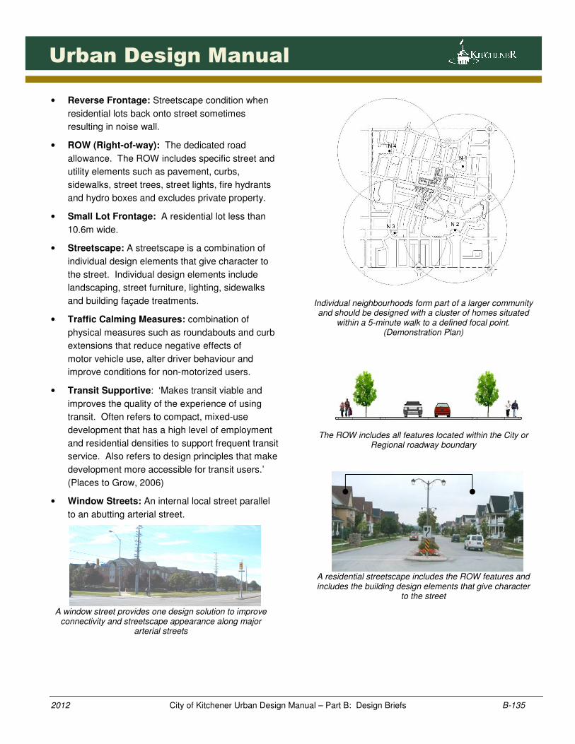
2012 City of Kitchener Urban Design Manual – Part B: Design Briefs B-135
Urban Design Manual
• Reverse Frontage: Streetscape condition when
residential lots back onto street sometimes
resulting in noise wall.
• ROW (Right-of-way): The dedicated road
allowance. The ROW includes specific street and
utility elements such as pavement, curbs,
sidewalks, street trees, street lights, fire hydrants
and hydro boxes and excludes private property.
• Small Lot Frontage: A residential lot less than
10.6m wide.
• Streetscape: A streetscape is a combination of
individual design elements that give character to
the street. Individual design elements include
landscaping, street furniture, lighting, sidewalks
and building façade treatments.
• Traffic Calming Measures: combination of
physical measures such as roundabouts and curb
extensions that reduce negative effects of
motor vehicle use, alter driver behaviour and
improve conditions for non-motorized users.
• Transit Supportive: ‘Makes transit viable and
improves the quality of the experience of using
transit. Often refers to compact, mixed-use
development that has a high level of employment
and residential densities to support frequent transit
service. Also refers to design principles that make
development more accessible for transit users.’
(Places to Grow, 2006)
• Window Streets: An internal local street parallel
to an abutting arterial street.
A window street provides one design solution to improve
connectivity and streetscape appearance along major arterial streets
Individual neighbourhoods form part of a larger community and should be designed with a cluster of homes situated
within a 5-minute walk to a defined focal point. (Demonstration Plan)
The ROW includes all features located within the City or
Regional roadway boundary
A residential streetscape includes the ROW features and includes the building design elements that give character
to the street