Embed Size (px)
Citation preview

APPENDIX A
Hunters Pond Dam Removal Feasibility Study and
Preliminary Design

1
March 27, 2015 To: Nick Wildman
Priority Projects Coordinator Department of Fish and Game (DFG) Division of Ecological Restoration (DER) 251 Causeway Street, Suite 400 Boston, MA 02114
From: Princeton Hydro, LLC Laura A.S. Wildman, P.E. 931 Main Street, Suite 2 South Glastonbury, CT 06073 RE: Preliminary Design Memo
Hunters Pond Dam Removal Feasibility Study and Preliminary Design Scituate, MA
Dear Mr. Wildman: Princeton Hydro is pleased to provide this preliminary design memo summarizing our resource assessment, review of alternatives, sediment sampling and chemical analysis, hydrologic and hydraulic analysis, and engineering design.
Review of Existing Information
Princeton Hydro reviewed the following documents that we received from project partners and others:
• Scope of Work and design plans (USFWS, 1995) for the fishway retrofit; • Excerpt of the 1970 “Reback study”; • Gulf River Estuary Natural Resources Inventory (Urban Harbors Institute 2003); • 1999 Dam Inspection letter from Office of Dam Safety; • 2013 GZA, Inc. Visual Dam Condition Assessment; • Photographs of the site under different flows; • Letters to Office of Dam Safety from Charles Ladd & Nancy Mahoney Harris; • Inventory of Historic and Archaeological Assets of the Commonwealth (online MACRIS
maps and site files); • Property Boundary maps; • LiDAR mapping; • Seven years of aerial photographs from 1995 – 2010; • USDA-Natural Resources Conservation Service Soil Survey maps; • MassGIS data layers, including water resources, wetlands, Natural Heritage and
Endangered Species, impaired waters, hydrography and underground storage tanks; • U.S. Fish and Wildlife Service-National Wetlands Inventory maps; • U.S. Geologic Survey Topographic maps; • USGS gage data; • NOAA Tidal gage data; and, • Effective FEMA HEC-RAS model including upstream CLOMR data.
This image cannot currently be displayed.
Scientists, Engineers & Environmental Planners Designing Innovative Solutions for Water, Wetland and Soil Resource Management

2
Existing Site & Dam Conditions
The Hunters Pond Dam (aka Mordecai Lincoln Road Dam) is situated along Mordecai Lincoln Road in Scituate, Massachusetts, within the South Coastal River Basin in Plymouth County (42°13.3696N lat, 70°47.3454’W long) and impounds Hunter’s Pond. According to the 1999 Dam Safety Inspection the dam is a 10 feet high reinforced earthen fill, gravity type, roadway structure, with a 6 foot hydraulic head. According to the Massachusetts Office of Dam Safety (Dam Safety) the dam is classified as a SMALL sized dam with a SIGNIFICANT (class II) hazard classification due to the downstream development (Notice of Inspection, Mordecai Lincoln Road Pond Dam, MA02472, Department of Environmental Management, Office of Dam Safety, December 6, 1999). According to the inspection report the dam was in FAIR condition; however, according to a 2013 inspection by GZA, Inc. (discussed below) the dam is in POOR condition. According to Dam Safety, the Mordecai Lincoln Dam is owned by Marjory Ladd & Chittenden Trust Co. and Charles Murphy in North Situate, MA; however, the Ladd Family contests their ownership. According to the 1970 Reback study1, Hunters Pond Dam was breached in 1969 and when flow was sufficient, alewives entered the Pond. The fish run did not reach full potential, according to the report, due to passage difficulties and poor water regulation. With the dam breached, the authors predicted that anadromous fish passage would improve. At a public informational meeting on January 10, 2013, attendees stated that in the late 1970s pond abutters, along with the dam owner, performed restoration work at the dam to repair the breach, restore the dam, and raise the pond level. However, a review of files at Office of Dam Safety found no records related to this work. Without any supporting documentation of the work performed, it is not known whether this work received the necessary permitting or environmental review, or if the design and construction conformed to engineering design standards. The dam’s primary spillway is concrete and is located along the southern side of the road embankment just upstream of the old stone masonry Mordecai Lincoln Bridge. The dam’s auxiliary outlet includes a weir gate structure and a 7-foot diameter corrugated metal pipe (CMP) that extends under Mordecai Lincoln Road and the adjacent mill building. The road embankment itself makes up the majority of the dam structure. There are two concrete pool-and-weir fishways built into the concrete spillway structure. Both are currently inoperable. Hunter’s Pond is a 2 acre impoundment that extends approximately 600 feet south of the Mordecai Lincoln Road crossing. A large impounded sediment delta has formed over the years in the center of the pond and it becomes densely vegetated during the summer months. Our field observations confirmed the dam’s degraded condition. The concrete on the dam’s spillway is spalling in several areas and the spillway itself is leaking. One prominent hole was observed at the base of the spillway during low flow conditions. In addition, the 7-foot diameter CMP auxiliary outlet, which extends under the road and beneath the mill structure, is in extremely poor condition and the weir gate’s crank-operated lifting mechanism is currently inoperable due to a snapped coupling at the end of the gate’s connecting shaft. The entire base of the auxiliary outlet CMP has corroded out, leaving only the sides and roof of the CMP remaining. If not repaired, this pipe could easily fail, endangering both the stability of the dam embankment (i.e. road) and the mill structure. At a minimum, the 1999 Dam Safety Inspection report for the Mordecai Lincoln Dam required that: 1 Reback, K.E. and DiCarlo, J.S. 1970. Completion Report, Anadromous Fish Investigation, Massachusetts AFC-1. Massachusetts Division of Marine Fisheries. Boston, MA.

3
• The trees and brush growth on the upstream slope, downstream slope, and toe and channel areas be removed;
• The debris at the spillway approach and discharge areas be removed; • The condition and operation of the auxiliary outlet gate be investigated; • The settling granite blocks be realigned; • The flashboards to facilitate fish ladder operation be installed; and, • A dam maintenance and operation program be implemented.
In 2013, GZA GeoEnvironmental, Inc. was contracted by the Town of Scituate to complete a dam safety inspection, with recommendations for maintenance and repair, and cost estimates. GZA rated the overall condition of Mordecai Lincoln Road Pond Dam to be in POOR condition and recommended the following Remedial Actions:
1. Clear trees and woody vegetation from embankment and backfill with compacted sand and gravel.
2. Repair and re-grade upstream slope and install riprap slope protection. 3. Install a graded filter blanket to control seepage observed at downstream toe of dam. 4. Repair and re-grade downstream slope using dumped riprap or rockfill. 5. Rehabilitate outlet works (repair or replace conduit and slide gate). 6. Repair concrete defects at spillway.
GZA’s opinion of probable cost, for all recommended and potential work, was estimated to be $450,000 - $750,000. On Jan 10, 2013 a new Dam Safety law was established in Massachusetts, creating a $17 million state revolving loan fund and grants to provide low-interest long-term loans to dam owners to remove or repair their unsafe dams. The law also gives Dam Safety the authority to increase fines for allowing dams to fall into hazardous condition, from $500 to $5,000 per violation and $5,000 for every continuous violation. Owners of all high and significant hazard dams are required to prepare Emergency Action Plans for their dams. In addition, the owners of high hazard dams are required to prepare dam inspections every 2 years and every 5 years for significant hazard dams. The responsibility for inspections and maintenance of a dam therefore falls to the dam owners.

4
Figure 1. Existing aerial of the site
Adjacent reaches were investigated and surveyed to inform the design. Flow downstream of the dam is bifurcated by the dam into two channels. The main channel coming from the dam spillway is heavily armored with boulders in the bed and a dry-laid fieldstone rock wall forming the left bank (looking downstream). Due to this manipulation, this channel is narrow and deep (13 feet wide, 5.5 deep) and drops approximately 5 feet over 200 linear feet (2.5% slope). Higher flows over-top the river right bank and spread out across the interfluve zone (i.e. the land between the two channels where the channels converge). The river right channel, controlled by the overflow weir, drops several feet from the 7-foot CMP into a scour pool directly under the existing mill house. This channel receives less flow, contains a broader array of sediment sizes (boulder, cobble, gravel) and is approximately 8 feet wide and 4.5 feet in depth. Both of these channels are steep and capable of transporting most incoming sediment and yet subject to tidal backwater; fine gravel and sand bars are deposited at the downstream ends, near their confluence. The armored boulder/cobble streambeds (and stonewall banks) render the channels highly resistant to any geomorphic adjustment2 that could be initiated by modifications to the dam upstream. Upstream of the impoundment, approximately 500 feet upstream of Henry Turner Bailey Road, the primary channel is approximately 15 feet wide and 2.5 feet deep; however, flow is bifurcated through a shrub wetland complex. Banks were low sloping, and densely vegetated and stabilized by woody shrubs, herbaceous vegetation and boulders. The limit of impoundment influence was discerned by the first pronounced change in water surface and stream bed profile observed upstream of the dam; however, hydraulic conditions are heavily influenced by the three bridges immediately downstream. Dam removal will restore normal stream flow conditions to this reach, but little geomorphic adjustment is anticipated. 2 Geomorphic adjustment is defined as extensive and long-lasting changes in channel cross-section, slope or alignment.
Figure 2. Bridge at County Way.

5
In the impoundment, bedrock outcrops feature prominently on the river left bank. Bedrock will likely influence the alignment and configuration of the restored channel through the impoundment, primarily by shifting the channel away from the river left (west) shore and potentially creating a meander in the central portion of the impoundment. No defined bedrock ledge was observed that would be anticipated to create a severe flow constriction or potential blockage to upstream fish migration. Bridges in the upstream reaches were also visually inspected. The Old Colony Railway bridge and Country Way bridge are in good condition, with no spalling or cracking. Engraving on the concrete abutment indicates the Country Way Bridge was last repaired or replaced in 2008. In contrast, the Bridge at Henry Turner Bailey Road is severely degraded. Extensive concrete spalling on the upstream face has exposed reinforcement. Concrete spalling and severe cracking on the downstream face also threatens the structural integrity of the bridge.
Figure 3. Old Colony Railway bridge, from downstream (left) and upstream (right).
Figure 4. Bridge at Henry Turner Bailey Road.
Note concrete spalling and cracking, and exposed rebar.
Hydraulic modeling (detailed below) confirmed that the hydraulic conditions during most flows are dictated by the bridge at Country Way and as such, any modification or removal of the dam will not adversely impact these three bridges.
Cultural Resource Assessment
On April 5, 2013 Public Archeological Laboratory conducted a review of the Inventory of Historic and Archaeological Assets of the Commonwealth (online MACRIS maps and site files) maintained by the Massachusetts Historical Commission (MHC). Based on this review, there are no recorded archaeological sites within a one-half mile radius of the dam site. However, the dam is located within or adjacent to the Mordecai Lincoln Historic Area (MHC #SCI.M), comprised of 37 historic resources that date primarily from the nineteenth and twentieth centuries. The historic area is recommended eligible

6
for listing in the National Register of Historic Places under Criteria (A) and (C)3 at the local level in the areas of community planning and development, industry, and architecture. The historic area also includes the late seventeenth century, ca. 1690 Mordecai Lincoln Homestead/Mill Complex (SCI.116 and SCI.117) at 62-69 Mordecai Lincoln Road. The homestead/mill complex property is located closest to the dam site and is noted for its high individual architectural merit and potential local historical significance, and as such is evaluated for individual listing in the National Register of Historic Places under Criteria A and C at the local level in the areas of industry and architecture. The homestead/mill complex property may also be eligible for listing under Criterion B for its association with Mordecai Lincoln, one of the early industrialists of the area and great, great, great, grandfather of President Abraham Lincoln. The earliest dam was built ca. 1690 by Mordecai Lincoln for his sawmill and grist mill, and a mill was present and operating at this location on Bound Brook through the late 1800s. The existing dam is not identified as an individual resource within the historic area or the homestead/mill complex. Additional historical research would be needed to determine the full extent of waterpower infrastructure associated with the seventeenth through nineteenth-century Mordecai Lincoln mill complex, including the Bound Brook raceway and possible earlier dam remains. A Project Notification Form was completed and submitted to the Massachusetts Historical Commission with the Preliminary Design Plans (see Appendix).
Economic and Community Considerations
This project is funded in part, by a grant from the GOMC-NOAA Habitat Restoration. The mission of the GOMC (Gulf of Maine Council) Partnership is "to maintain and enhance environmental quality in the Gulf of Maine and to allow for sustainable resource use by existing and future generations." This mission explicitly recognizes the economic network, community character, and cultural history that is supported by healthy and self-sustaining coastal resources and seeks to support these priorities through ecological restoration. Historically river herring were important commercial species used fresh or salted for human consumption, and used for bait, fish meal, and fish oil and that as previously discussed, they are an important food source for other commercially and recreationally important fish species. The Town of Scituate Master Plan, adopted by Annual Town Meeting, March 13, 204, discusses the economic and community importance of the Town's fishing industry. A stated objective of the Economic Development section of the Master Plan is to "preserve and enhance local natural resource-based commercial activities such as fishing". According to the Town's Master Plan, the fishing industry makes less of a contribution to the Town's economy than it did in the past, this is largely due to depletion of fish stocks and associated restrictions and closures in fisheries. The plan indicates that there are 15 full-time boats that regularly fish for fin-fish and utilize the Town's commercial fish pier and that there are approximately 10 smaller boats that are part time lobster and fin-fish boats. In 1997, 54 Scituate residents listed their occupation as fisherman or lobsterman. The report also states that in 1998, the value of fish off-loaded from commercial fishing vessels in Scituate Harbor was valued at $2,839,000. 3 The Criteria for Evaluation: The quality of significance in American history, architecture, archeology, engineering, and culture is present in districts, sites, buildings, structures, and objects that possess integrity of location, design, setting, materials, workmanship, feeling, and association, and: (A) That are associated with events that have made a significant contribution to the broad patterns of our history; or (B) That are associated with the lives of significant persons in or past; or (C) That embody the distinctive characteristics of a type, period, or method of construction, or that represent the work of a master, or that possess high artistic values, or that represent a significant and distinguishable entity whose components may lack individual distinction; or (D) That have yielded or may be likely to yield, information important in history or prehistory.

7
The Fisheries section of the Master Plan concludes "While commercial fishing is not as significant in the local economy as it once was in either sales or employment, it is critical to the Town's identity and an important part of its coastal scenery. Scituate retains the appearance of a working port. This attracts visitors to visit the Harbor and its retail stores, as well as local restaurants for their fresh seafood menus". In support of this local priority the Economic Development section of the Master Plan recommends that all natural resources that support Scituate's fisheries and shellfish be protected. This project is consistent with and directly supports the goals, objectives and recommendations of the Town's Master Plan.
Complementary Activities and Supporting Recommendations
This project complements other efforts by the Town of Scituate to restore fish runs (and associated economic, fisheries, community character, and cultural benefits) within town. The Town of Scituate spear-headed an innovative project where a project team composed of municipal, state, federal, and non-profit partners developed a proactive water management and stream flow initiative to restore a historic anadromous fish run in First Herring Brook. In acknowledgement of this significant effort, the Scituate Water Department and Department of Public Works received the 2012 GOMC Sustainable Community Award. The Town of Scituate is embarking on a project to restore and improve the Town's Commercial Fishing Pier in Scituate Harbor in support of its commercial fishing industry. This project will cost $407,000 and is being funded by a cost share agreement with the Mass Seaport Council paying 80% of the cost and the Town of Scituate paying the remaining 20%. Specific to Bound Brook, an Interbasin Transfer Act (ITA) review included the development of a model to simulate water surface elevations and flow from Lilly Pond and Aaron River Reservoir and led to release recommendations for maintaining anadromous fish passage within Bound Brook. The permit issued under the ITA in 2004 included requirements for Cohasset to monitor Bound Brook discharge and uphold a minimum water release target to support river herring adult immigration and juvenile emigration. Work and maintenance at the fish ladders at the Aaron River Reservoir and the Bound Brook Control Structure (BBCS) have ensured that they are in good working order and capable of passing fish. In total, fish passage potential throughout the Bound Brook system is quite viable with the exception of the Hunters Pond Dam. In addition to being consistent with and supporting the recommendations of the Scituate Master Plan and complementing other municipal initiatives, the project follows recommendations from a variety of regional reports. The South Coastal Watershed Action Plan, developed by the Watershed Action Alliance of Southeastern Massachusetts, under contract by the MA Executive Office of Environmental Affairs, identified Hunters Pond Dam as a significant factor contributing to the impairment of the Bound Brook system and recommended investigating the feasibility of removing the dam in order to substantially increase the amount of smelt spawning habitat and improve river herring passage in this sub-watershed. The MA Department of Environmental Protection South Shore Coastal Watershed 2001 Water Quality Assessment Report listed Bound Brook as impaired for aquatic life due to fish barriers and the Dam's impacts in fish passage and recommended that the removal of the dam could provide substantial
8
opportunity for increasing the amount of smelt spawning habitat and improving herring passage in this subwatershed. The Massachusetts Division of Ecological Restoration has conducted a state-wide evaluation of potential ecological benefits from restoration associated with dam removal projects. In this restoration potential model, the Hunters Pond Dam scored 25 restoration potential points which put it in the 95th percentile for all ranked dams. Factors contributing to this ranking were benefits associated with coldwater habitat, the dam's location at or near the head of tide, area associated with Living Waters Supporting habitat, the relatively limited road density in the sub-watershed, and the low number of dams below it.
Ecological Considerations
River ecosystems are dynamic linear networks that provide habitat and nutrients for a broad spectrum of aquatic and semi-aquatic biota, from simple to complex life forms. They also serve as important conduits between terrestrial, freshwater, estuarine, and marine environments. Streams and rivers convey water and sediment, as well as nutrients and pollutants, from high elevations to the oceans. Meanwhile, in free-flowing rivers, fish and other organisms move up-gradient, transporting nutrients back to higher elevations on the landscape. Dams fragment this linear habitat, preventing organisms from moving freely, and thus disrupt river continuity. Hunters Pond Dam causes a cascade of impacts in water quality, geomorphology and ecology that adversely affect Bound Brook. The impoundment that is broader than the channel increases exposure to direct insolation that in turn increases water temperatures. Higher temperatures reduce the capacity of water to retain dissolved oxygen, which is essential to sustaining aquatic life. In addition, the absence of turbulent, shallow flow through the channel reduces the typical aeration that is also important for maintaining high dissolved oxygen concentrations. The combination of these factors renders the impoundment unsuitable for cold water organisms, including fish and benthic macroinvertebrates with high oxygen demands. Since water from the surface flows over the spillway, which is also the warmest and lowest in dissolved oxygen, flows over the spillway, warm water impacts are conveyed to downstream reaches and The Gulf River. The creation of pond conditions, with warmer water temperatures and lower dissolved oxygen, likely alters the fishery community native to Bound Brook, toward less valued warm-water species. Conversely, the feeding, rearing, and spawning success of cool-water species is likely suppressed. With the reduction in flow velocity and the imposition of a barrier in the channel, sediment transport is severely interrupted. The expanding vegetated sediment delta in Hunters Pond is evidence that the dam traps and retains all sediment transported as bedload as well as a large fraction of the suspended load. The retention of associated nutrients contributes to the rapid growth of vegetation within the sediment delta. If the dam remains in place as is, this process of sediment accumulation in the Hunters Pond will continue and follow a predictable sequence whereby Hunters Pond will gradually revert to a wetland and eventually a floodplain with defined channel banks running up to the spillway. Within the influence of the dam, the former habitat features, such as pools and riffles have been inundated by slack-water and buried by incoming sediment rendering them uninhabitable by many desirable benthic macroinvertebrates, which serve as food sources for the base of the aquatic food chain. Likewise, the artificially elevated and nearly static water level behind the dam precludes the

9
hydraulically diverse habitat conditions (i.e. fast-deep, fast-shallow, slow-deep, slow-shallow) which provide greater foraging opportunities for benthic macroinvertebrates and fish. Finally, the most apparent environmental degradation posed by Hunters Pond Dam is the obstruction of the movement of migratory fish (alewife, blueback herring, American eel, rainbow smelt and sea lamprey). The persistence of this barrier serves to limit access to essential breeding areas, limit necessary genetic exchange, limit access to important habitats during other life stages, and contribute to the continual decline or stagnated recovery of these species. Alewife and blueback herring, collectively referred to as river herring, are keystone species in coastal ecosystems as they are a significant food source for many commercially and recreationally important fish species. Due to recent significant population declines, NOAA National Marine Fisheries Service designated river herring as a Species of Concern in 2006. The decline is partially attributed to dams and degraded water quality. In addition, in January 2006 the Massachusetts Division of Marine Fisheries implemented a 3-year moratorium on the taking of river herring that was extended in 2008 and again in 2012 due to the lack of recovery in the population.
Delineation of Regulated Natural Resources
A complete inventory of natural resources regulated by all applicable municipal, state and federal laws was completed by Wetland Strategies and Solutions (see stand-alone report in Appendix). Multiple areas regulated under Town of Scituate Bylaw, Massachusetts Wetland Protection Act, and Riverfront Protection Act were identified onsite. The following brief descriptions are abridged from the Appended report, with measured dimensions:
• Inland Resource Areas o Inland Bank:
Perimeter of the Pond; approximately 1,727 linear feet. Along the Brook upstream of the Pond; approximately 1,659 linear feet.
o Bordering Vegetated Wetlands (BVW): Along the border of the Pond, beginning approximately 260 feet south of the
Dam / Mordecai Lincoln Road extending landward on both sides of the Pond to approximately the 13-foot elevation contour; 972 linear feet.
Emergent wetlands in sediment delta; approximately 15,260 square feet.
o Land Under Water Bodies and Waterways (LUWW): Land under Hunters Pond; approximately 110,538 square feet.
o Bordering Land Subject to Flooding (BLSF): Extent of the 100-Yr Floodplain, obtained from FEMA.
o Riverfront Area: Extends 200 feet landward from mean annual high water line of bound Brook
(does not apply to Hunters Pond). • Coastal Resource Areas
o Coastal Bank: Seaward of Mordecai Lincoln Road, along the lengths of the outside edges of the
west and east channels down to their confluence; and along the perimeter of the upland knob on the island located between the two channels. Approximate length is 665 linear feet.

10
o Salt Marsh: Lower portion of the land at confluence of east and west channels that is tidally
influenced; approximately 4,562 square feet. In addition, the Natural Heritage and Endangered Species Program indicated the presence of a threatened plant species in the forested swamp adjacent to Bound Brook upstream of Country Way and Henry Turner Bailey Road. NHESP requires the submission of additional information (this design memo, with appendices, and preliminary design plans) to review and comment on the project. Under Section 404 of the Federal Clean Water Act, the US Army Corps of Engineers (USACE) regulates the discharge of dredged or fill material into waters of the U.S. The regulated areas include (i) the channels downstream of Hunters Pond Dam / Mordecai Lincoln Road, and (ii) up to the ordinary high water mark of Hunters Pond and Bound Brook or to the extent of adjacent wetlands (in this instance, approximately equivalent to BVW described above). In addition, the removal of the dam will require authorization under Section 10 of the Rivers and Harbors Act of 1899. Compliance with these regulations is achieved through a Massachusetts Programmatic Permit which must be accompanied by this design memo, preliminary design plans, and a Public Notice. Finally, the dam removal may require a Letter of Map Revision (LOMR) from FEMA.
Sediment Distribution and Quantity
While a bathymetric survey was beyond the scope of this project, Princeton Hydro probed (4/3/2013 – 4/4/2013) throughout the impoundment to ascertain the general character and distribution of impounded sediments. Unconsolidated, organic-rich sediments were concentrated in a delta in the center of the impoundment that is dominated by submerged and emergent, rooted, aquatic vegetation. Sediment depths ranged from 0.5 feet on the margins and the upstream extent to 4.5 feet in depth in the center of the delta. The central deposit of sediments is delineated by two flow paths, on the east and west sides of the impoundment. The two flow paths are distinguished by deeper water (5.5 feet max), lack of aquatic vegetation, and consolidated, coarse-grained sediments (sand and gravel) with some cobbles and boulders. Flow to the spillway follows the western flow path; flow to the culvert / historic mill building follows the eastern flow path. Figure 1 compares these features in two aerial photos (Google Earth). The left aerial photo (dated 4/17/2008) is prior to the growing season during open water conditions similar to those encountered during the field investigation. The aerial on the right (dated 6/18/2010) shows dense emergent aquatic vegetation on the shallowest portions of the sediment delta, and is more typical of the impoundment under low summer flows.

11
Figure 5: 4/17/2008 Pre growing season aerial of impoundment (left) and 6/18/2010 summer aerial of impoundment (right).
Figure 6: 12/05/2012 winter photo of impoundment (left) and 7/20/2012 summer photo of impoundment (right). Bedrock outcrops were common on the western side of the impoundment; however, no potential channel constriction was observed or encountered during probing (although water level in the impoundment during the field investigation was at normal stage). Based on our field investigation it is not anticipated that fish passage following dam removal would be encumbered through the existence of a currently submerged bedrock ledge or small falls. However, if the Town draws down the pond level before final design this can be confirmed.
12
The volume of the impounded sediments in Hunters Pond is estimated to be approximately 3,000 cubic yards, based on the sediment distribution and probing depths described above. If the dam were to be fully removed, the channel that reforms within the impoundment would approximate the inflowing channel and transition to the out-flowing channels downstream of the Mordecai Lincoln Road bridge. As a single-threaded channel, width is anticipated to be approximately 25 feet. Under this scenario, it is likely that the majority of the impounded sediment delta would not be released downstream but rather would re-vegetate as a wetland/riparian floodplain. Preliminary design aspects, discussed in subsequent sections, include seeding/planting this area with desirable native plants, however it is anticipated that the site would quickly re-vegetate on its own once dewatered. Additional plantings help establish more beneficial and less opportunistic vegetation species. Subsection 314 CMR 9.07 (401 Water Quality Certification) requires, for projects with less than 10,000 cubic yards, that one sample be taken for every 1,000 cubic yards of anticipated “dredged” materials. Since most impounded sediments will likely be retained as floodplain (i.e., not mobilized or excavated), the total estimated volume of impounded sediments (3,000 CY) was used as a conservative basis for determining that three (3) samples satisfies the requirement defined by 314 CMR 9.07. The portion of sediment that is potentially mobile is related to the channel configuration of the final design. Under a single channel design (i.e. with no flow through the auxiliary channel), the potentially mobile portion of sediment is estimated to be approximately 500 CY. Under a bifurcated channel design, the mobile portion is estimated to be approximately 800 CY. This potentially mobile portion is limited to the impounded sediment immediately adjacent to the spillway/weir, and along the legacy channel(s) within the impoundment. New vegetation that is anticipated to establish itself rapidly post dam removal and the current root mass that has already established on the impounded delta during periods of low flow, in addition to erosion and sedimentation control methods, will help stabilize remaining areas of impounded sediment and limit downstream migration of impounded sediment.
Potential Pollutant Sources in Watershed
The Gulf River Estuary Natural Resources Inventory (Urban Harbors Institute 2003) was consulted to assess environmental concerns and known pollution sources. Mapping in this report, indicate along Bound Brook several, commercial / Industrial / Institutional sites and approximately four (4) “Sites Generating Hazardous Waste (RCRA)”. Two hazardous spill sites, RCRA Corrective Action Sites were identified in the Bound Brook watershed: (1) Norfolk Conveyor (Seavy Engg and H&W Ind), 155 King Street, Cohasset; and (2) Wompatuck State Park, Rte 3A, Hingham. In addition, the inventory cites a report published by Norfolk Environmental (1998) that documented elevated concentrations of VOCs and PAHs and lead; corrective action(s) had been implemented and were found to be successful in preventing off-site migration of contaminants. The varied land uses and potential sources contaminants warranted sampling and analysis for a broad suite of contaminants (identified below) of impounded sediments in Hunters Pond.
Sediment Sampling
Following the 401 Water Quality Certification and Dredge Permit Form process described in the Dam Removal and Wetland Regulations (MADEP, Bureau of Resource Protection, Wetlands and Waterways Program, 2007), Princeton Hydro determined that past and present land use practices, and the predominance of fine sediments, necessitated sediment sampling and laboratory analysis. Sediment samples were collected downstream of the impoundment (#1), within the impoundment (#2, 3, 4), as well as, upstream of impounded flow (#5, not pictured) approximately 500 feet upstream of Henry Turner Bailey Road. The downstream sample (#1) was extracted near the confluence of the west and

13
east channels, from the channel substrate and a depositional area on the channel margin. Samples #2 and #3 were extracted from the impounded sediment delta, which, due to the predominance of fines (silts, clays, and organic muck), have the highest affinity for contaminants and therefore provide a worst-case condition of sediment contamination. Sample #4 was extracted from the upstream extent of the Pond and thus incorporated coarser material. The upstream channel was predominantly gravel; sample #5 was extracted from the channel margin and thus contained mostly sand that is highly mobile during above normal flows and likely migrates through the reach in single storm events. Samples were collected using a stainless steel Ponar sediment sampler or acetate tube (depending on sediment cohesiveness and retrieval success) which were cleaned of gross particles and decontaminated between sediment sampling locations (non-phosphate detergent, methanol, and distilled water) so as not to cross-contaminate samples. Samples for VOC analysis were extracted immediately from undisturbed sediment cores with laboratory-supplied devices. Remaining material was then homogenized and placed in sterile bottles and an ice-filled, insulated cooler supplied by the laboratory, and transported via courier to Alpha Analytical, LLC laboratories in Westborough, MA and Mansfield, CT. The samples were analyzed for a suite of pollutant parameters in accordance with 314 CMR 9.07 of the 401 Water Quality Certification Regulations, which include: RCRA metals (8), Polycyclic Aromatic Hydrocarbons (PAHs, 16), Polychorinated biphenyls (PCBs, 22 congeners), Extractable Petroleum Hydrocarbons (EPHs, 4), Volatile Organic Compounds (VOCs, 73), moisture, total solids, total organic carbon, and grain size. Samples for grain size analysis were transported to Integrated Analytical Laboratories LLC (IAL) in Randolph, NJ.
Sediment Quality Guidelines
Following guidance from MADFG Division of Ecological Restoration (MassDER)4, results were compared against human health, freshwater and marine sediment quality criteria. 4 Hackman, A. 2009. Sediment Quality Spreadsheet. MS Excel spreadsheet. Massachusetts Department of Fish and Game, Division of Ecological Restoration.
Figure 7: Sediment Sample Locations

14
Human health criteria are based on Massachusetts Contingency Plan Method 1 Cleanup Standards for S-1 (soils) and GW-1 (groundwater) (MCP S1/GW1). These human health criteria are typically based on daily direct contact over a long-term period, and thus serve as the most conservative threshold for human health risk. Freshwater criteria are consensus-based, freshwater sediment quality guidelines compiled by MacDonald and Ingersoll5. Marine criteria are consensus-based, saltwater sediment quality guidelines developed by Macdonald et al.6 Consensus-based Sediment Quality Guidelines (SQGs) have been developed to synthesize previously published toxicity studies and have been shown to be accurate predictors of both sediment toxicity and the absence of toxicity to benthic invertebrates by direct contact. These SQGs have been established in two-tiers: the Threshold Effect Concentration / Level (TEC/TEL) and Probable Effect Concentration / Level (PEC/PEL). TEC is the concentration below which harmful effects are unlikely to be observed; PEC is the concentration above which harmful effects are likely to be observed. MassDER utilizes the PEC as the primary criteria. These SQGs do not consider the potential for bioaccumulation and are not intended to serve as site-specific clean-up levels. Instead, they are applied to facilitate the decision-making process regarding sediment management; an absence of exceedances generally serves as a defensible basis for no further investigation.7 Simple statistics (minimum, maximum, mean) were computed for the three samples collected from within the impoundment. All three sets of criteria (human health, freshwater and marine) are applicable on this site. Firstly, the edges of the existing impoundment and the pronounced sediment delta in the center of the impoundment will likely be exposed, becoming soil by regulatory definition, and will re-vegetate upon dam removal. This area will remain accessible by the adjacent residential properties. Secondly, upon dam removal, the impoundment will revert to a freshwater fluvial channel and floodplain. Thirdly, while the current head of tide reaches the Mordecai Lincoln Road crossing; portions of the impoundment will likely be exposed to salt water intrusion during higher high tides.
Laboratory Analytical Results
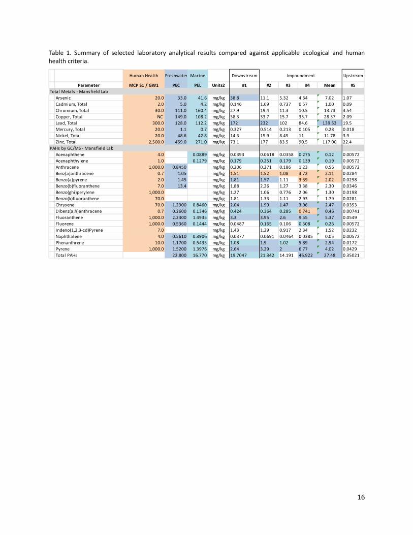
Complete laboratory results are included in the ppendix and a summary table is provided below (Table 1). Human health criteria were exceeded for only three parameters, all PAHs. One parameter (benz(a)anthracene) exceeded the human health criterium (0.7 mg/kg) in the three impoundment samples (#2, 3, 4) and the downstream sample (#1). As a result, mean concentration for benz(a)anthracene (2.11 mg/kg) in the impoundment samples exceeded the human health criteria by 3x. Two other related parameters (dibenz(a,h)anthracene = 0.741 mg/kg, benzo(a)pyrene = 3.39 mg/kg) exceeded human health criteria (0.7 mg/kg, 2.0 mg/kg) in one impoundment sample (#4). Mean concentrations of benzo(a)pyrene in the impoundment (2.02 mg/kg) were nearly equivalent to the human health criteria (2.0 mg/kg). Freshwater and marine criteria were also exceeded mainly by PAHs, which are described in more detail below. 5 MacDonald, D.D., and Ingersoll, C.G. 2002. A Guidance Manual to Support the Assessment of Contaminated Sediments in Freshwater Ecosystems, Volume III – Interpretation of the Results of Sediment Quality Investigations. 6 MacDonald, D.D, and R.S. Carr, F.D. Calder, E.R. and C.G. Ingersoll. 1996. Development and evaluation of sediment quality guidelines for Florida coastal waters. Ecotoxicology 5:253-278. 7 MacDonald, D.D., Ingersoll, C.G., and Berger, T.A. 2000. Development and Evaluation of Consensus-Based Sediment Quality Guidelines for Freshwater Ecosystems. Archives of Environmental Contamination and Toxicology. 39:20-31.

15
Metals: In the downstream sample (#1), Arsenic (38.8 mg/kg) slightly exceeded the freshwater PEC (33.0 mg/kg) and Lead (172 mg/kg) exceeded the freshwater PEC (128.0 mg/kg) and marine PEL (112.2 mg/kg). In one impoundment sample (#2), Lead (232 mg/kg) also exceeded the freshwater PEC and marine PEL. No metals exceeded the human health criteria. No exceedances were detected in the upstream sample (#5). PAHs: The downstream sample (#1) exceeds freshwater and/or marine criteria for eight (8) PAHs. Mean concentrations for impoundment samples exceed the freshwater or marine criteria for ten (10) PAHs. The exceedances are within an order of magnitude of the criteria, ranging from 1.75 to 5 times the criteria. As discussed above, three (3) PAHs exceeded the human health criteria. Both the downstream and impoundment samples (#1, #2, and #4) exceeded the marine criterium for Total PAHs (16.770 mg/kg); sample #4 exceeded the freshwater criterium as well. As a result, the mean concentration for Total PAHs in the impoundment (27.48 mg/kg) slightly exceeded the freshwater criterium (22.800 mg/kg). No exceedances were detected in the upstream sample (#5). PCBs: PCB congeners were either detected in low concentrations or were not detected at all. Six (6) congeners were detected in the downstream sample at low concentrations (0.0016 – 0.0044 mg/kg). Similarly, 13 congeners were detected in two impoundment samples (#2, 4) at low concentrations (0.0012 – 0.0049 mg/kg). The maximum concentration (sample #2, 0.0411 mg/kg), and thus the mean concentration, were below the Freshwater PEC (0.6760 mg/kg) and the Marine PEL (0.1890 mg/kg). PCBs were not detected in the upstream sample (#5). VOCs: Most VOCs (71 of 73) were not detected in any samples. Two VOCs, 2-butanone and acetone, were detected in the three impoundment samples. Human health criteria are established for six (6) VOCs; those contaminants were not detected in any samples. VOCs were not detected in the upstream sample (#5). EPHs: Most were either detected well below the Human health criteria or not detected at all. EPHs were not detected in the downstream (#1) or upstream (#5) sample. No exceedances were detected for any parameter in the upstream sample (#5). Physical Characteristics: Samples #1, #2, #3, #4 contained high moisture content (72-82%); and total organic content ranged from 4% to 8%. The upstream sample (#5) contained lower moisture content (32%) and lower total organic content (0.5%). Sample #1 contained the greatest proportion of coarse grains (gravel = 1.2%, coarse sand = 19%). Samples #2 and #3 contained the highest proportions of silt and clay (31%, 28%), and were the only samples that did not contain any gravel. Sample #4 is predominately medium sand (62%), with fine sand (30%). For impoundment samples (#2, 3, 4), mean silt and clay composition was 21%. Sample #5 is predominantly fine sand (59%), with medium sand (35%).
16
Table 1. Summary of selected laboratory analytical results compared against applicable ecological and human health criteria.
Human Health Downstream Upstream
Parameter MCP S1 / GW1 PEC PEL Units2 #1 #2 #3 #4 Mean #5Total Metals - Mansfield Lab
Arsenic 20.0 33.0 41.6 mg/kg 38.8 11.1 5.32 4.64 7.02 1.07Cadmium, Total 2.0 5.0 4.2 mg/kg 0.146 1.69 0.737 0.57 1.00 0.09Chromium, Total 30.0 111.0 160.4 mg/kg 27.9 19.4 11.3 10.5 13.73 3.54Copper, Total NC 149.0 108.2 mg/kg 38.3 33.7 15.7 35.7 28.37 2.09Lead, Total 300.0 128.0 112.2 mg/kg 172 232 102 84.6 139.53 19.5Mercury, Total 20.0 1.1 0.7 mg/kg 0.327 0.514 0.213 0.105 0.28 0.018Nickel, Total 20.0 48.6 42.8 mg/kg 14.3 15.9 8.45 11 11.78 3.9Zinc, Total 2,500.0 459.0 271.0 mg/kg 73.1 177 83.5 90.5 117.00 22.4
PAHs by GC/MS - Mansfield LabAcenaphthene 4.0 0.0889 mg/kg 0.0393 0.0618 0.0358 0.275 0.12 0.00572Acenaphthylene 1.0 0.1279 mg/kg 0.179 0.251 0.179 0.139 0.19 0.00572Anthracene 1,000.0 0.8450 mg/kg 0.206 0.271 0.186 1.23 0.56 0.00572Benz(a)anthracene 0.7 1.05 mg/kg 1.51 1.52 1.08 3.72 2.11 0.0284Benzo(a)pyrene 2.0 1.45 mg/kg 1.81 1.57 1.11 3.39 2.02 0.0298Benzo(b)fluoranthene 7.0 13.4 mg/kg 1.88 2.26 1.27 3.38 2.30 0.0346Benzo(ghi)perylene 1,000.0 mg/kg 1.27 1.06 0.776 2.06 1.30 0.0198Benzo(k)fluoranthene 70.0 mg/kg 1.81 1.33 1.11 2.93 1.79 0.0281Chrysene 70.0 1.2900 0.8460 mg/kg 2.04 1.99 1.47 3.96 2.47 0.0353Dibenz(a,h)anthracene 0.7 0.2600 0.1346 mg/kg 0.424 0.364 0.285 0.741 0.46 0.00741Fluoranthene 1,000.0 2.2300 1.4935 mg/kg 3.3 3.95 2.6 9.55 5.37 0.0549Fluorene 1,000.0 0.5360 0.1444 mg/kg 0.0487 0.165 0.106 0.508 0.26 0.00572Indeno(1,2,3-cd)Pyrene 7.0 mg/kg 1.43 1.29 0.917 2.34 1.52 0.0232Naphthalene 4.0 0.5610 0.3906 mg/kg 0.0377 0.0691 0.0464 0.0385 0.05 0.00572Phenanthrene 10.0 1.1700 0.5435 mg/kg 1.08 1.9 1.02 5.89 2.94 0.0172Pyrene 1,000.0 1.5200 1.3976 mg/kg 2.64 3.29 2 6.77 4.02 0.0429Total PAHs 22.800 16.770 mg/kg 19.7047 21.342 14.191 46.922 27.48 0.35021
Freshwater Marine Impoundment

17
Table 1. (Continued) Summary of selected laboratory analytical results compared against applicable ecological and human health criteria.
Sediment Results Interpretation
The distribution of sediment contaminants revealed by laboratory analysis follows predictable patterns. First, samples from the impoundment (#2, 3, 4) contained the greatest percentage of fine sediments (silts and clays) and, as a general result, higher contaminant concentrations were detected in these samples. However, for many contaminants, comparable concentrations were detected in the downstream and impoundment samples. The upstream sample had little to no detected contaminants, owing primarily to the coarser sediment composition, as well as the high mobility and short residence time. Similar concentrations of PAHs have been detected in impounded sediments during dam removals throughout the northeast. Based on this experience, these detected concentrations appear to represent regional, not just local, background levels. The PAHs that were detected above applicable criteria (benzo(b)fluoranthene, benzo(a)pyrene, benzo(k)fluoranthene) are a class of compounds, generally
Human Health Downstream Upstream
Parameter MCP S1 / GW1 PEC PEL Units2 #1 #2 #3 #4 Mean #5PCB Congeners by GC/MS - Mansfield Lab
Cl10-BZ#209 mg/kg 0.00152 0.002 0.0016 0.0014 0.0017 0.00057Cl2-BZ#8 mg/kg 0.00152 0.0011 0.0016 0.0014 0.0014 0.00057Cl3-BZ#18 mg/kg 0.00152 0.0011 0.0016 0.0014 0.0014 0.00057Cl3-BZ#28 mg/kg 0.00152 0.0011 0.0016 0.0014 0.0014 0.00057Cl4-BZ#44 mg/kg 0.00152 0.0011 0.0016 0.0014 0.0014 0.00057Cl4-BZ#49 mg/kg 0.00152 0.0011 0.0016 0.0014 0.0014 0.00057Cl4-BZ#52 mg/kg 0.00152 0.0021 0.0016 0.0014 0.0017 0.00057Cl4-BZ#66 mg/kg 0.00152 0.0012 0.0016 0.0014 0.0014 0.00057Cl5-BZ#101 mg/kg 0.00185 0.0032 0.0016 0.0017 0.0022 0.00057Cl5-BZ#105 mg/kg 0.00152 0.0012 0.0016 0.0014 0.0014 0.00057Cl5-BZ#118 mg/kg 0.00248 0.0027 0.0016 0.0014 0.0019 0.00057Cl5-BZ#87 mg/kg 0.00152 0.0016 0.0016 0.0014 0.0015 0.00057Cl6-BZ#128 mg/kg 0.00152 0.0011 0.0016 0.0014 0.0014 0.00057Cl6-BZ#138 mg/kg 0.00441 0.0049 0.0016 0.0017 0.0028 0.00057Cl6-BZ#153 mg/kg 0.00312 0.0036 0.0016 0.0014 0.0022 0.00057Cl7-BZ#170 mg/kg 0.00152 0.0016 0.0016 0.0014 0.0015 0.00057Cl7-BZ#180 mg/kg 0.00251 0.0036 0.0016 0.0014 0.0022 0.00057Cl7-BZ#183 mg/kg 0.00152 0.0011 0.0016 0.0014 0.0014 0.00057Cl7-BZ#184 mg/kg 0.00152 0.0011 0.0016 0.0014 0.0014 0.00057Cl7-BZ#187 mg/kg 0.00159 0.0018 0.0016 0.0014 0.0016 0.00057Cl8-BZ#195 mg/kg 0.00152 0.0011 0.0016 0.0014 0.0014 0.00057Cl9-BZ#206 mg/kg 0.00152 0.0016 0.0016 0.0014 0.0015 0.00057Total PCBs 0.6760 0.1890 0.0403 0.0411 0.0359 0.0307 0.0359 0.0126
Extractable Petroleum Hydrocarbons - Westborough LabC11-C22 Aromatics 1,000.0 mg/kg 26.8 38.2 31.8 82.8 50.9 9.54C19-C36 Aliphatics 3,000.0 mg/kg 26.8 38.2 35.9 30.9 35.0 9.54C9-C18 Aliphatics 1,000.0 mg/kg 26.8 38.2 28.6 22.8 29.9 9.54C11-C22 Aromatics, Adjusted mg/kg 26.8 38.2 31.8 54.2 41.4 9.54
General Chemistry - Mansfield LabMoisture % 75.5 82.8 77.3 72.4 77.5 32.7Solids, Total % 24.5 17.2 22.7 27.6 22.5 67.3
Total Organic Carbon - Mansfield LabTotal Organic Carbon (Rep1) % 7.19 7.99 3.96 5.19 5.71 0.517Total Organic Carbon (Rep2) % 6.11 8.2 4.88 4.04 5.71 0.535
Particle Size (%) - IALTotal Organic Carbon mg/kg 63500 80800 65900 13500 53400 376% Gravel (#4) % 1.2 0.00 0.00 0.45 0.15 0.69% Coarse Sand (#10) % 19.01 3.09 3.17 3.61 3.29 4.01% Medium Sand (#40) % 39.93 29.31 27.78 62.17 39.75 35.39% Fine Sand (#200) % 28.11 34.96 39.8 30.06 34.94 59.15% Silt & Clay % 11.17 31.9 28.38 2.3 20.86 0.63
Freshwater Marine Impoundment
18
occurring as complex mixtures and commonly occur in fine sediments (fine sand, silt, clay) in river systems. These compounds are the by-product of incomplete combustion (i.e., low temperature) particularly of coal and petroleum fuels. Sources include wildfires, industrial processes, energy production, motor vehicles, food preparation, and smoking. They enter freshwater bodies via atmospheric deposition or stormwater runoff and then bind preferentially to fine sediments, which settle out of suspension in backwater depositional areas such as man-made impoundments like Hunters Pond. Most contaminants analyzed (metals, PCBs, VOCs, EPHs) do not present a concern to human health, or freshwater and marine environments. Concentrations of some PAHs in the impoundment and the downstream reach may present a minor impact to the aquatic ecosystem under existing conditions. Dewatering of the impoundment and the conversion to naturalized floodplain may reduce the impact to the aquatic environment. Concentrations of three PAHs in the impoundment and the downstream reaches present a very minor human health risk due to the low risk of daily direct contact. These results provide reasonable assurance that no further investigation is necessary and that sediment quality is sufficient to support dam modification or full removal.
Sediment Management
In the proposed design, the majority of sediments shall be stabilized on-site while the mobile portion shall be allowed to reposition naturally as the remnant channels re-form. This approach follows the “in-stream management” alternative described in Dam Removal and Wetland Regulations (MassDEP, 2007) and is enabled by the existence of the relict channels, the relatively small mobile quantity, and the general lack of contamination. Where necessary, sediment on the channel margins will be repositioned to create stable bank slopes. Throughout the impoundment, banks will be seeded and erosion control fabric will be installed to facilitate bank stability immediately following dam removal. The above sediment management approach will be supported by appropriate construction practices that include water and erosion control practices. Initially, the impoundment will be partially dewatered utilizing the auxiliary weir, or if necessary, modification of the spillway. This controlled dewatering will allow sediments to remain in place and drain gradually. The presence of the aquatic vegetation rootmass, as well as rapidly emerging herbaceous vegetation, will further stabilize the impounded sediments in place. Demolition of the spillway will be conducted in a slow, controlled manner utilizing saw-cutting techniques and a hydraulic hammer attachment on an excavator, which allows for the removal of concrete in manageable portions. During demolition of the spillway, sediments in the immediate vicinity will be shifted laterally to areas that will become floodplain under proposed conditions. The Town and project partners are advised to seek informal regulatory input on this sediment management approach prior to filing permit applications; final sediment management approach is subject to change following regulatory input.
Preliminary Hydrologic and Hydraulic Analysis
Preliminary hydrologic and hydraulic analysis was completed as part of Hunters Pond Dam Removal Feasibility and Preliminary Design on Bound Brook in Scituate, MA. This analysis satisfies the current level of design and project decision-making, but will likely need to be updated during final design and permitting, and to complete a Letter of Map Revision (LOMR), if required. The purpose of the analysis is

19
to inform feasibility of the proposed design by assessing changes in flood elevations, fish passage conditions, as well as impacts to adjacent structures. Storm flow conditions were examined to identify changes to the upstream water surface elevation during high flows under post dam removal conditions, while low flows were utilized to investigate fish passage conditions through the site. Princeton Hydro acquired and installed a water level monitoring gage (Solinst 3001 LT Levelogger Junior Edge) at the spillway of Hunters Dam (upstream side) and a barometric pressure gage (Solinst 3001 LT Barologger Edge) above flood height at the intersection of South Main Street and Mordecai Lincoln Road in Cohasset, MA. The gages are activated and data has been retrieved by the Town via a computer with Levelogger Series Software 4. The stream gage is actively logging water depths to develop a long-term record for use during final design, regardless of the final alternative selected. Data from 4/2 to 6/10 has been acquired.
Hydrology
Given the range of flows necessary to inform project design and objectives, several data sources were utilized to establish hydrologic conditions for the project.
Methodology
For low flow data, the upstream historic USGS gage (USGS 01105660 BOUND BROOK NEAR COHASSET, MA) was utilized. Median Daily Mean Discharge (DMD) data for the short period of record (1970-1971, 1.2 years) was obtained via USGS website, and was analyzed to identify flow values for specific conditions. Because the historic gage was located much further upstream than the subject dam, USGS flow values were transposed to the project site utilizing a ratio of the drainage areas. Specifically, 5th and 95th exceedance values were determined for both the period of record and for the spring migratory period (i.e. April, May, June), and 50th percentile (median) of DMD values were examined to determine approximate baseflow values. According to NOAA analysis of regional flow data (Flood Frequency Estimates for New England River Restoration Projects: Considering Climate Change in Project Design), flood frequency and magnitude have shown increasing trends since 1970 at many New England reference stream gages. Due to this regional hydroclimatic trend, the agency recommends comparing pre-1970 and post-1970 flow data in project watersheds to discern and account for measurable increases. However, this additional analysis was not possible due to the 1.2 year dataset. Given the short period of record, and that the entire data set is prior to completion of the dam forming Aaron River Reservoir, additional hydrologic methodologies were utilized to lend more confidence in the data sets. USGS StreamStats analysis was also completed at the dam location, and provides a range of low flows (50th percentile and lower) relatively consistent with both USGS data, and field observations. Additionally, preliminary data from the pressure transducer installed by Princeton Hydro upstream of the spillway was analyzed to determine a stage-discharge rating curve for the existing outlet works. All three data sources are relatively consistent, and as such can be used with confidence in the preliminary design and feasibility analysis. Continued data collection at the pressure transducer will allow further refinement of the rating curve, and estimated discharges, and utilization in more detail in future phases of design.

20
For storm flows, the existing FEMA Flood Insurance Study (FIS), dated July 2012, was utilized to obtain flow values for various storm events including the 10-, 50-, 100-, and 500-year recurrence interval events. As the FIS flow values were given directly for Hunters Pond Dam, no transposition was necessary. No further analysis of storm flow data was completed as these flows were deemed sufficient for both design and regulatory purposes. This removal may require Letter of Map Revision (LOMR) from FEMA at a later phase of project work. Multiple USGS regression equations (unpublished) were utilized to determine the range of estimated bankfull discharge, as well as other bankfull geometry variables. These values were compared to both our upstream and downstream field observations, and cross-sectional geometry within the impoundment to inform anticipated channel conditions likely to form in the restored impoundment under various scenarios. As the reach downstream of Hunter’s Pond Dam is subject to tidal influence, analysis of available regional tide gage data was necessary. This tidal range could then be utilized in the hydraulic modeling as one of the analyzed downstream boundary conditions to inform both fish passage, and potential for tidal influx post-removal. For this site, the closest most applicable tide gage is NOAA Tide Station 8443970, located near Boston, MA. For both analysis and anticipated regulatory requirements, multiple tide elevations are of interest. Specifically, mean high water (MHW), highest astronomical tide (HAT), and the highest observed tide (HOT) were obtained directly from the NOAA Tide Station output. As portions of the anticipated regulatory process (USACE) use High Tide Line (HTL), it was necessary to obtain a value for that jurisdictional boundary, as well. Following review of regulatory definitions, it was determined that the HTL and HAT definitions are nearly identical, and as such, HTL was assumed equal to HAT for this project. Elevations associated with these jurisdictional boundaries are as follows: MHW = 4.33’ NAVD88, HTL (HAT) = 6.92’ NAVD88, and HOT = 9.09’ NAVD88. Refer to the appendices for the entire range of tidal data obtained for this project.
Results
Based on the above analyses, the following flows shown in Table 1 below were determined and utilized for the subsequent hydraulic analysis. Additional relevant hydrologic data are included in the appendices.

21
Table 2. Stream discharges under various scenarios.
Hydraulics
In order to perform the hydraulic analysis, various existing data were compiled to represent the geometry of Bound Brook, under both existing conditions and multiple alternatives for post dam removal conditions. The existing hydraulic model data available from FEMA for this reach, was obtained from STV, Inc., in digital format, February 2013. This HEC-RAS model was utilized previously for a CLOMR application to FEMA for the upstream bridge replacements at Country Way and the Railway, but was not of sufficient detail within the vicinity of the dam, and as such it was necessary to create entirely new geometry through this reach. Results from the above hydrologic analysis were utilized in the hydraulic analysis. (This hydraulic model was updated in March 2015 with additional survey data capturing previously inaccessible floodplain areas and additional cross-sections; results were unchanged from those described below, and as such final model output will be re-generated for final design.)
Methodology
Existing topographic survey information obtained by GM2 Associates, Inc. was utilized to define in-stream cross-sectional geometry for the subject stream reach, essentially from downstream of the Country Way Bridge crossing, through the dam, and downstream into the tidal zone. Aerial topographic data (LiDAR) obtained from the MassGIS was used to append the in-stream topography for areas outside of the edge of water. These data were combined and pre-
Hunter's Pond Dam Removal Feasibility Hydrology Summary
Statistic Discharge (cfs) Description
Storm Flows
FEMA 10-yr 370 10-yr peak discharge from FIS
FEMA 50-yr 635 50-yr peak discharge from FIS
FEMA 100-yr 950 100-yr peak discharge from FIS
FEMA 500-yr 1400 500-yr peak discharge from FIS
Low Flows
HFPDF 55 High Fish Passage Design Flow, 5th percentile exceedance DMD, period of record
LFPDF 0.5 Low Fish Passage Design Flow, composite 95th percentile exceedance DMD, multiple methods
Baseflow 12 Estimated Baseflow, 50th percentile (median) of the DMD
Geomorphic Flows
Bankfull 240 Estimated Bankfull Discharge, ~1.5- to 2-yr recurrence interval

22
processed using the USACE HEC-GeoRAS. This interface allows the preparation of geometric data within the ArcGIS platform for import into HEC-RAS. For this hydraulic model, 42 cross-sections from Station 1.91 (approximately 1500 ft upstream of the State Route 3A) to Station 0 (limit of detailed topography, approximately 200 ft downstream of Mordecai Lincoln Road) were utilized as representative of the geometry of the Bound Brook through this reach. Within this modeling reach, Station 0.043 is identified at the existing Hunter’s Pond Dam spillway, with the roadway embankment at Station 0.040. The Manning’s roughness coefficients, ‘n’, for the stream channel and overbanks were assigned to each cross section. These ‘n’ values were evaluated and assessed from Princeton Hydro’s site visits, with horizontal variation as necessary due to bank vegetation (0.05 – 0.095, varying with density/type of vegetation), and channel substrate (0.03 – 0.065, varying with substrate type/degree of vegetation influence), including anticipated adjustment with proposed conditions (0.045 0.05, accounting for anticipated herbaceous vegetation in the impoundment post-removal). Hunter’s Pond Dam spillway under existing conditions was defined using an in-line structure. Under post dam removal conditions, geometry at all sections in which sediment removal or transport is anticipated were adjusted to detail both the dam removal as well as proposed minor excavation or natural sediment transport. Given the relatively complex split flow over the auxiliary (eastern) overflow weir continuing under the historic adjacent building, and limitation with the one-dimensional model, discharge through that reach was determined using the split flow routine with a lateral weir, and was subtracted from the main stem flow and then subsequently added back into main stem flow, at appropriate flow change locations. The HEC-RAS model utilized in this study was a one-dimensional, steady peak flow, mixed flow analysis, using flows generated from the hydrologic analyses. Both existing conditions and post-dam removal conditions were analyzed with the geometry modifications as described above. Both upstream and downstream boundary conditions were set to normal depth using a slope value obtained from the profile topography, with both mean high water (MHW), and Highest Observed Tide (HAT) for the tidal influence scenarios. For all model runs, the energy, steady flow, standard step modeling procedure with mixed flow conditions was utilized to determine the water surface profile.
Results
Relevant results including stage discharge relationships, WSEL, depths, and velocities for appropriate model runs are included as appendices to this report, and summarized in the sections below in relation to capacity, WSEL, fish passage and tidal influence.
Capacity and Water Surface Elevations (WSEL)
During low and moderate flows, upstream WSELs are controlled by both the primary spillway, and the auxiliary weir, with the flow split governed by weir elevations/lengths. This holds true as flow increases up through the 100-yr event, with the capacity of the bridge maxing out at approximately 850 cfs, before Mordecai Lincoln Road begins overtopping in flows in excess of the 100-year. Once the road overtops (during flows in excess of the 100-year event), upstream WSEL is controlled by the entire weir of the roadway embankment. As such, removal of the primary spillway has little effect on upstream WSEL during the 100- and 500-year events, with
23
the maximum effects (decrease in WSEL) during the lowest flows. However, because the entire outlet works (both bridge opening and auxiliary outlet) function during the regulatory event (100-yr), capacity must be maintained with any proposed modifications, so as not to raise upstream WSEL, and potentially violate FEMA requirements. Assuming that the bridge capacity cannot be upgraded (historic, etc.) to increase flow through the main channel, this means flow must be maintained through the eastern auxiliary weir/pipe. Additionally, given the stability concerns with the current historic structure above the auxiliary outlet, it was further recommended that flow not be increased through the auxiliary outlet during storm events. It is noted that the existing (baseline) modeled WSEL during the FEMA FIS flows is lower than the reported values in the FIS. This is most likely attributed to updated geometry in the completed model more accurately accounting for flow through the entire existing outlet works (both spillway and overflow weir).
Fish Passage
Minimum depths of 1 FT and maximum velocities of less than 6 FPS during flows of the fish passage period are considered to be generally sufficient to accommodate the range of target migratory fish. Calculated maximum average velocities for the modeled fish passage flows within the proposed modified reach (existing impoundment) are all less than 5 fps, while calculated depths are greater than 1 ft for the HFPDF, and Baseflow. For the extreme low-flow LFPDF (0.5 cfs) fish passage is limited by depths through the riffle downstream of the road crossing, under existing conditions, and this limitation persists through all of the proposed conditions. During these extreme low-flows, bifurcation through two channels may present passage issues at low-tide. As compared to the fish passage requirements for the listed species of concern, these maximum velocities do not exceed the burst speeds of the species of concern in the adult life stage. In addition, the water depths are adequate for the species of concern in all life stages. These results suggest that the anticipated post-removal conditions will successfully pass species of concern through the bridge crossing over the range of modeled flows, aside from the existing limitation during extreme low-flows. It is noted that as currently configured (and once slip lined as proposed) the auxiliary culvert has a +1 FT to 2 FT hydraulic plunging flow drop at its downstream end that will likely create a full passage barrier for some of the target fish species under most flows. It is for this reason that the project proponents may wish to consider the “Auxiliary Overflow” option within Alt #3, to deter fish from being attracted to the eastern channel below the auxiliary outlet.
Tidal Influence
Under existing conditions, normal tidal influence extends essentially into the main stem bridge under Mordecai Lincoln Road, and into the eastern tributary channel under the historic mill, but not up into the 7’ CMP of the auxiliary outlet. Proposed conditions at this phase in Preliminary Design will not change normal tidal influence on the former impoundment, based on mean high water. Based on the Highest Observed Tide (HOT) resulting from storm related tidal surge, and the Highest Astronomical Tide (HAT), or the highest tide under normal lunar cycles, proposed conditions would open up the impoundment to infrequent tidal inundation. Given that the existing bridge opening will still function as a restriction in high flows, both fluvial in the downstream direction and tidal surge in the upstream direction, anticipated impacts would be associated only with water surface elevation, not velocities. For the HOT, tidal influence during a normal baseflow would extend approximately 1,300 feet upstream of Mordecai Lincoln Road,

24
whereas under the HAT, that influence would be limited to approximately 600 feet upstream of Mordecai Lincoln Road. However, it should be noted that modeled WSEL during these events under proposed conditions are all less than the existing normal pool elevation.
Design Alternatives
Public Participation Princeton Hydro was tasked with determining if dam removal was feasible and identifying potentially critical engineering and resource issues that could increase the potential cost for the dam removal option. However, in parallel with our effort, the Town of Scituate also hired GZA to further investigate the dam’s condition and make recommendations regarding the repair of the dam to ensure that the dam met current dam safety codes if it remains.
On 12 March 2013 at 6pm, Albert Bangert (Director of Public Works) and Patrick Gallivan (Scituate Conservation Agent) met with 5-6 residents who own property abutting Hunters Pond. The meeting was in response to their request to learn more about the project and discuss their concerns. The meeting was hosted by William Hale in a conference room at his place of business in North Scituate. Also participating in the meeting was Ann Merton, an environmental consultant hired by Mr. Hale. The concerns and issues primarily center on:
• Existing wildlife • Potential alternatives for the dam and
available funding (most notably the cost to repair the dam)
• View and aesthetics • Dam safety
• Flooding • Acceptable road loading and the
potential for bridge closure • Impoundment infilling and dredging • The potential for mudflats and
increased mosquito populations
In addition, helpful insights and data were contributed by the neighborhood stakeholders regarding the history of the site, the dam/sluice gate, the pond/river, the dam’s construction, and the sediment infilling, as well as the fact that there is no known record of the Mordecai Lincoln Road overtopping. At the public meeting the Town gave a clear description regarding the current condition of the dam and their concerns relating to the road, the dam and paving, as well as a description of the current economic limitations, including the dam owner’s inability to fund repairs and the Town’s lack of interest in taking over ownership and maintenance responsibility for the dam. Suggestions were made at the meeting regarding the development of a Pond Association, made up of concerned stakeholders, to purchase, repair and maintain the dam if the surrounding neighborhood wished the dam to remain.
Regardless of the final alternative selected for the Mordecai Lincoln Dam by the dam owners, approval of this project through the regulatory process will be contingent upon avoiding adverse impacts where feasible, then minimizing and mitigating unavoidable impacts to the Inland and Coastal Resources identified above as well as satisfying Commonwealth dam safety regulations.
The following summary of design alternatives have been developed and compared, as part of the MEPA (e.g., Environmental Notification Form) approval process. The project is being pursued to accomplish multiple public safety, legal, and environmental objectives. Specifically, these objectives include (i) addressing the dam’s poor condition and leakage, (ii) absolving the current dam owners of any future liability, and (iii) restoring fish passage for alewife, blueback herring, American eel, rainbow smelt and sea lamprey. The existing fishways are ineffective at passing migratory fish and therefore comprise an existing adverse impact. In addition the impoundment, Hunters Pond, has been filling with sediment over time and a large central sediment delta now exists within the impoundment.

25
Alternative #1: No Action
As dams are costly to maintain and insure, the owners must weigh actions and costs over the short, medium and long terms. Hunters Pond Dam is currently in degraded condition, rated “Poor” according to the 2013 visual assessment, and is actively leaking in multiple locations. In addition the entire bottom of the corrugated metal pipe (CMP) that acts as an auxiliary outlet has corroded and washed away, and the weir gate at its upstream end has a snapped coupling along the gate’s connecting shaft, leaving it inoperable. Deferring action at this time would allow the dam to continue to deteriorate and may require more costly repairs or a complete rebuild in the future, as well as increased risk of failure and damage to other property and infrastructure. While “No Action” does not create any new impacts to Inland or Coastal Resource Areas, the option fails to accomplish any of the three project objectives: dam safety, liability, and fish passage. The existing adverse impact to fish passage would remain and the impoundment would continue to fill with sediment. As the sediment accumulates and becomes exposed at the surface it will vegetate, transitioning the open water pond to a vegetated wetland with a perched stream still dependent on the dam to maintain the higher water table at this manmade elevation.
The Town of Scituate would like to pave Mordecai Lincoln Road due to drainage and erosion issues but will not do so with the auxiliary CMP outlet in such poor condition. If the dam repair order issued by the Office of Dam Safety goes unanswered, it is likely that the “No Action” alternative will result in costly fines being assessed to the dam owners.
Alternative #2: Repair (or Replace) Dam and New Fishway
This alternative would likely entail structural enhancements to halt seepage, repair concrete spalling on the spillway, removal of trees and brush along the dam’s embankment, repair of the auxiliary pipe outlet and the weir gate, resetting of the granite blocks, and the development of an operation and maintenance program as well as an Emergency Action Plan, as currently required by the Office of Dam Safety. In addition, the repair may also lead to a complete re-design and re-build of the entire outlet works (i.e. bridge, spillway and embankment) due to the fact that the capacity is limited by the bridge opening, as described above in the Hydrology and Hydraulics section. The dam would remain in place and therefore require continued monitoring and maintenance. Retrofitting the fishway will likely require the demolition of the current fishways and re-construction of a new fishway, due to the fishways’ existing vertical drops and plunging flow that are beyond the swimming abilities of the target species. The dam repair/replacement alternative will likely be substantially more costly than the other alternatives.
This alternative does not create any new long-term impacts to Inland or Coastal Resource Areas, other than the continued infilling of the impoundment, and it would address two of three primary project objectives: dam safety and improved fish passage. It will also address the desire of some of the abutter to keep the pond aesthetic; however, if not combined with costly pond dredging, the open water aesthetic will not be maintained in the future. While the dam safety concerns are met in the short term, the dam will require long term maintenance. And while fish passage will be improved with a new fishway, it is important to note that any fishway is considered partial fish passage because fishways are designed to pass only selected life stages of specific target species, within a bracketed flow window representing a percentage of the migratory period for the target species. Finally, the third objective is not met; the current dam owners will continue to retain the liability for the dam and the responsibility for continued maintenance. Since the dam owners and Town have no interest in maintaining the dam, a viable financially responsible alternative dam owner would need to be found. The new dam owner or owners would then be responsible for the dam repairs (or replacement) along with the long term maintenance and liability of dam ownership, as per the newly updated MA Office of Dam Safety

26
guidelines. Dam inspections will be required to be completed once every two years by the dam owner(s) due to the “Significant” dam hazard classification, as previously set by the Office of Dam Safety. The dam owner(s) will then be responsible for completing any recommended repairs promptly or risk fines assessed by Dam Safety.
Once the dam has been repaired or replaced the Town of Scituate would be able to proceed with their plans to pave Mordecai Lincoln Road.
Alternative #3: Remove Dam and Restore Channel / Floodplain
Full Removal of the dam and restoration of the channel and adjacent floodplain meets all the project objectives and is the preferred alternative for which the preliminary designs have been developed. This alternative entails demolition and removal of the spillway structure and fishways, and re-creation of a stream channel through the impoundment, as well as stabilization and planting of the currently impounded sediment. This alternative follows a predictable regulatory pathway within MassDEP and would permanently satisfy all three project objectives. Without the structure (and any of its associated maintenance and monitoring), dam safety and liability are no longer a concern. With a restored channel, fish passage would be restored to pre-dam conditions. Since this alternative involves fully dewatering the impoundment, it would involve temporary impacts to the existing Inland and Coastal Resource Areas. These impacts and the design details are discussed below in the full description of the proposed alternative.
Dam removal is the preferred alternative at this time primarily because no alternate dam owner has stepped forward to assume the responsibilities of dam ownership. This alternative thereby eliminates the need to find an alternate dam owner to take over ownership, monitoring, maintenance, and liability for the dam. However, it does remove the open-water aesthetic that Hunter Pond currently provides and transitions the open water habitat to free flowing riparian habitat.
As discussed in the hydraulic assessment in this design memorandum, the Mordecai Lincoln Road Bridge and the auxiliary outlet are the primary hydraulic controls at this site, not the dam’s spillway. Therefore even if the spillway is fully removed the WSEL’s and impoundment effects remain identical under existing and proposed conditions for the 100 year storm event, even if the dam’s spillway is fully removed. It was initially hoped that the auxiliary outlet could be completely closed off and filled to eliminate the long term maintenance requirements of a road culvert in this location, post spillway removal. However, due to the limited flow capacity through the bridge opening, closing off the auxiliary outlet completely would lead to a minor increase in the 100 year flood elevations upstream (~2 inches), which would likely not be acceptable to FEMA and the Town.

27
We therefore investigated three alternatives to address the auxiliary outlet, these included the:
A. Enhanced Flow Capacity Alternative – This alternative would include slip-lining auxiliary outlet pipe and fully removing its associated weir gate. However, we now believe that this option will likely prove infeasible since it would increase the flows under the Mill structure during periods of high flow and therefore, potentially, promote increased risk and maintenance to the mill structure.
B. Auxiliary Overflow Alternative – This alternative would include the slip-lining of the auxiliary outlet pipe and modification of its inlet, such that the lower portion of the pipe is blocked off with a fixed weir inlet attachment. This alternative would eliminate the freshwater base flows to the eastern channel downstream of the dam, thereby reducing the fish passage cues into the perched auxiliary culvert. The eastern channel would still be backwatered daily by tidal flow, but would act only as an auxiliary overflow channel for freshwater storm flows.
C. Baseflow Maintenance Alternative - This alternative would include the slip-lining of the auxiliary outlet pipe and modification of its inlet, such that the upper portion of the pipe is blocked off with a fixed office control structure inlet. This alternative would maintain freshwater base flows in the eastern downstream channel but would restrict higher flows during floods to match the existing conditions under the Mill structure. At this preliminary design stage we have assumed that this alternative will be preferred; however the final selection will be determined after further discussion with the Town, dam owners and project partners. One potential issue with this approach is that the base flows would attract fish to the eastern channel that might then be blocked by the perched culvert under the road. This alternative could be modified to completely replace the existing pipe with an open bottomed culvert instead of merely slip-lining the pipe; however, an open bottomed culvert alternative at this location would be very costly and require bracing and modification of the Mill foundation during the construction.
Under Alternate #3B - Auxiliary Overflow (slip lining of 7’ CMP, in-kind replacement of overflow weir), perennial flow would no longer discharge through the eastern outlet, with low to moderate flows diverted entirely through the main stem bridge. Discharge at the eastern outlet during larger storm events was maintained at existing conditions levels. As such, proposed WSEL for the 100-yr is maintained at the existing conditions WSEL, with WSEL during low to moderate events decreasing by 2-4 feet.
Under the Alternate #3C - Baseflow Maintenance (slip lining of 7’ CMP, removal of overflow weir), given the invert elevations of the main channel at the bridge and the 7’ CMP pipe at the eastern overflow vary approximately 0.2 feet, flow split under low flows is anticipated to be nearly 50/50. The pipe restriction has been preliminarily sized to prevent increased discharge through the auxiliary culvert during storm flows, but allow perennial flow through both outlets. Preliminarily, this sizing was completed to maintain the 100-yr flow, however during final design, this opening size could be iterated to maintain existing flows through the culvert during all storm events (e.g. 10-yr and up).
Preliminary Design: Dam Removal and River Restoration
Based on the (i) investigation of the impoundment, upstream and downstream reaches, (ii) characterization and analysis of impounded sediments, (iiI) identification of the regulated areas, and (iv)

28
hydrologic and hydraulic analysis, Princeton Hydro proposes the following preliminary design: full demolition and removal of the dam’s concrete spillway, concrete apron, and fishway (with the use of saw cutting to avoid impacting the masonry bridge abutments and piers); slip-lining of the culvert under the Mill building and reconfiguration of the upstream inlet to allow for uninterrupted base flow while minimizing high flows through the culvert that might damage the mill structure; re-creation of approximately 700 linear feet of bifurcated channel; and stabilization and conversion of the existing impoundment to approximately 2 acres of naturalized vegetated floodplain. A 6-inch cast iron water supply line currently crosses the impoundment just upstream of the dam. The Town has had plans to repair and relocate this water line beneath the Mordecai Lincoln Road; therefore the pipe will not be a hindrance to removal of the dam. Our site investigation and hydraulic modeling revealed no additional adverse impacts to upstream infrastructure, therefore no modifications or stabilization to infrastructure is proposed as part of this plan. The draft engineering design plans (30%) that accompany this memo provide description of the main features, a sequence of construction, and preliminary construction details.
The bifurcated channels within the former impoundment are proposed to follow the existing primary flow paths identified in the field and described above, which appear to convey the majority of flow through the impoundment. These channels are defined by “legacy thalwegs”, with greater water depths, compact, coarse-grained substrate, and little or no fine impounded sediments, thus minimizing the quantity of sediments that needs to be disturbed or relocated during construction. These channels follow a geomorphically compatible sinuosity and slope that is comparable to upstream and downstream reaches and is within typical ranges of stable channels in similar physiographic settings. This natural alignment avoids tight meanders, which supports stability in the short term following construction. In addition, existing bedrock outcrops will be allowed to influence channel dimension so as to create natural variability, avoid the uniformity of a constructed channel, enhance channel stability and diversify hydraulic conditions and bedforms. No cross channel bedrock formations were identified in the field, so at this time it is not anticipated that any small falls or bedrock cascades will be uncovered post dam removal that could potentially hinder fish passage.

29
Figure 8: Conceptual proposed dam removal design (see Preliminary Design Plans for more detail).
Channel widths are proposed to vary from 10 to 20 feet, based on the bifurcation of the measured dimensions of upstream and downstream reaches. Dewatered areas of the impoundment will be broadcast seeded with a native floodplain seed mix immediately upon dewatering. Banks within the former impoundment shall be stabilized initially with biodegradable erosion control fabric and planted with a variety of regionally native riparian tree and shrub species. Habitat features, pools and riffles, will be situated according to the proposed alignment and available substrate and allowed to develop naturally over time.
As mentioned above, tidal data from the nearest NOAA tide gage (8443970, Boston, MA), was accessed to assess the influence following full dam removal. The primary spillway of Hunters Pond Dam is situated just up-gradient of the head of tide (e.g., Mean High Water, 4.33’ NAVD88). As such, with only minimal and infrequent tidal influence, the impoundment will not revert to an inter-tidal wetland. However, full removal of the dam will allow for inland tidal incursions during less-frequent higher high tides and storm surges. Refer to the appendices for the entire range of tidal data obtained for the site.
The auxiliary outlet is proposed to be slip-lined and maintained for the conveyance of base flows, and will help to moderate high flows, as discussed in the “Base Flow Maintenance” Alternative described above. The final configuration of the auxiliary pipe inlet will control the magnitude of the flow that is directed through the culvert and under the mill. This level of design detail can be addressed in later phases of the project. This additional capacity of the secondary spillway will help maintain base flows to the eastern channel downstream and will reduce risk of flows over-topping Mordecai Lincoln Road.
According to the hydraulic model, water surface elevations will drop up to the Country Way Bridge with the restoration of free-flowing conditions. However, upstream of Country Way bridge, water surface elevations will not be changed by the dam removal because water surface elevations are controlled by the Country Way bridge and Old Colony Railway bridge. As such, no impacts to the bridge structures are anticipated.
30
Impacts to Regulated Resources
This preliminary design will trigger a well-known and predictable transition from impoundment to channel and floodplain setting. Dam removal, by necessity, involves the rapid reversion from an artificial pond, or lentic, system, with associated open-water and lacustrine wetlands, to a riverine, or lotic, freshwater system. In time, the riverine system should resemble (but not be equivalent to) pre-disturbance conditions. This drop in stage and dewatering of the impoundment causes a hydrologic alteration that triggers a transition through all trophic levels. The vegetation community, currently dominated by floating, rooted submerged, and emergent vegetation in the impoundment, will shift to a wetland/upland system dominated by both herbaceous and woody plants. Native riparian species will be given a headstart through implementation of the planting plan, which will add habitat value. The return of free-flow and sediment transport will restore sediment transport and sediment sorting and re-expose coarser stream substrate which will create new habitat for benthic macroinvertebrates such as insects, gastropods, bivalves, crustaceans, and oligocheates. Increased flow velocities, narrowing of the wetted width to a shaded stream corridor, reduced direct insolation, and the corresponding moderated water temperatures and increased dissolved oxygen concentrations will provide uplift to aquatic biota.
Based on the proposed preliminary design described above, Regulated Resources are anticipated to change as follows:
• Inland Resource Areas o Inland Bank: No net change in length; In the existing impoundment, IB will shift
laterally to the proposed edge of channel and may increase in length with the creation of the overflow channel. IB up to the Country Way bridge may shift slightly with drop in water surface elevation.
o Bordering Vegetated Wetlands (BVW): Along the margins of the current pond, will shift laterally down-gradient closer to the channel. Portions of the floodplain nearer the re-created stream channels will likely become BVW, particularly in response to the planting plan. BVW along the reach up to Country Way may shift slightly down-gradient with drop in water surface elevation.
o Land Under Water Bodies and Waterways (LUWW): Net reduction; will be reduced to area of proposed channels. LUWW along the upstream reaches may decrease slightly with drop in water surface elevation.
o Bordering Land Subject to Flooding (BLSF): No net change; storage for 100-year flood will increase, but area of inundation will remain approximately the same.
o Riverfront Area: Net increase; area adjacent to the proposed channel (where it did not apply in Hunters Pond) will be considered Riverfront Area. RA along the upstream reaches may shift slightly down-gradient with drop in water surface elevation.
• Coastal Resource Areas o Coastal Bank: No change likely. o Salt Marsh: No change.