Embed Size (px)
Citation preview
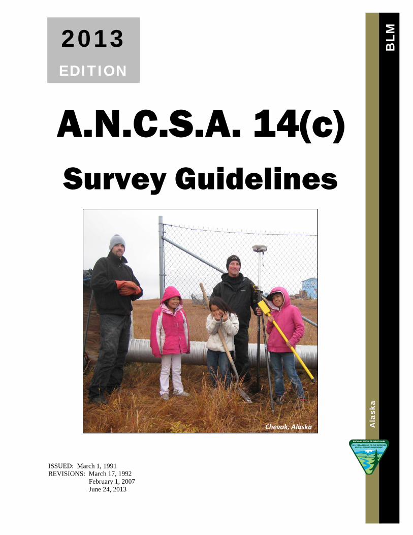
Chevak, Alaska
2013 EDITION
A.N.C.S.A. 14(c) Survey Guidelines
ISSUED: March 1, 1991 REVISIONS: March 17, 1992
February 1, 2007 June 24, 2013
BLM
A
lask
a

ii
A.N.C.S.A. 14(c) Survey Guidelines
U.S. Department of the Interior Bureau of Land Management
Alaska State Office 222 West 7th Avenue #13
Anchorage, Alaska 99513-7504
iii

iv
ANCSA 14(c) GUIDELINES
TABLE of CONTENTS
Chapter I. INTRODUCTION Page
A. General ----------------------------------------------------------------- 2 B. History ------------------------------------------------------------------- 3
Chapter II. MAP OF BOUNDARIES
A. Purpose --------------------------------------------------------------------- 8 B. Map of Boundaries Submittal Checklist ------------------------------- 8 C. Map of Boundaries Review Checklist --------------------------------- 9 D. Official Filing Date and Public Notice ------------------------------ 14 E. Changes or Amendments ---------------------------------------------- 16
Chapter III. SPECIAL INSTRUCTIONS FOR ANCSA 14(c) SURVEYS EXECUTED UNDER FEDERAL AUTHORITY
A. General-------------------------------------------------------------------- 18 B. Format and Content ----------------------------------------------------- 18
Chapter IV. FIELD SURVEY POLICY AND PROCEDURES
A. Purpose ------------------------------------------------------------------- 22 B. Pre-field Planning and Preparation ----------------------------------- 22 C. Preliminary Field Investigation --------------------------------------- 23 D. Limits and Closure ------------------------------------------------------ 23 E. Rectangular Aliquot Part Descriptions------------------------------- 24 F. Controlling Intermediate Monuments-------------------------------- 24
1. Witness Points ----------------------------------------------------------- 24 2. Witness Corners --------------------------------------------------------- 24
G. Meander Lines----------------------------------------------------------- 25 H. Corner Monuments, Accessories, and Reference Monuments --- 25
1. Monuments--------------------------------------------------------------- 25 2. Accessories---------------------------------------------------------------- 26
v
TABLE OF CONTENTS (continued)
Chapter IV. FIELD SURVEY POLICY AND PROCEDURES
3. Reference Monuments--------------------------------------------------- 29 I. Topography, Curves and Streets ---------------------------------------- 29
1. Topography --------------------------------------------------------------- 29 2. Curves---------------------------------------------------------------------- 29 3. Streets and Utilities ------------------------------------------------------ 29
J. Ties ------------------------------------------------------------------------- 30 1. Location Ties ------------------------------------------------------------- 30 2. Ties to Improvements --------------------------------------------------- 30
K. Control Stations ---------------------------------------------------------- 30 1. Full Field Recovery------------------------------------------------------ 30 2. Datum ---------------------------------------------------------------------- 30
L. Recovered Corners------------------------------------------------------- 31 1. Required Field Data------------------------------------------------------ 31 2. Remonumentation / Rehabilitation ------------------------------------ 31 3. Marks to be Added to Monuments ------------------------------------ 31
M. Resurveys / Retracement------------------------------------------------ 32 1. Retracement--------------------------------------------------------------- 32 2. Dependent Resurvey ---------------------------------------------------- 32 3. Accepting the Record---------------------------------------------------- 32 4. Record vs. Found Survey Lines---------------------------------------- 32
Chapter V. FIELD SURVEY RECORDS PREPARATION
A. Purpose --------------------------------------------------------------------- 35 B. General Guidelines-------------------------------------------------------- 35 C. Reporting on the Plat ----------------------------------------------------- 35
1. Bearings and Distances--------------------------------------------------- 35 2. Area ------------------------------------------------------------------------- 36 3. Rights-of-Way ------------------------------------------------------------- 36 4. Monumentation----------------------------------------------------------- 36 5. Accessories---------------------------------------------------------------- 36 6. Cultural Features --------------------------------------------------------- 36
D. Plat Memorandum ------------------------------------------------------- 37 Typical Checklist for Plat Memorandum ----------------------------- 38
E. Certificates ---------------------------------------------------------------- 38 F. Data to be Submitted to Review --------------------------------------- 39
Suggested Monument Symbols for ANCSA 14(c) Plat Legend -- 39 Typical Checklist for Survey Plat Preparation----------------------- 39
vi

vii
TABLE OF CONTENTS (continued)
Chapter VI. REVIEW AND EXAMINATION FOR IN-HOUSE AND CONTRACT (P.L. 93-638) SURVEYS
A. Administrative Functions ----------------------------------------------- 42 B. Critical Review --------------------------------------------------------- 42 C. Final Review -------------------------------------------------------------- 45 D. Survey Approval --------------------------------------------------------- 45
ANCSA 14(c) Survey Project Checklist for Reviewer ------------- 46
Chapter VII. RECORDING / FILING PROCEDURES FOR ANCSA 14(c) Page SURVEYS
Surveyed by BLM or under a P.L. 93-638 Contract ---------------- 49
viii
TABLE OF CONTENTS (continued)
APPENDICES
Appendix A. Documents and Forms:
(A-1) BLM: "Amended Policy Statement for Preparation ----------------- 52 and Processing of the Map of Boundaries Under ANCSA 14(c)"
(A-2) ANCSA: Section 14(c)(1), (2), (3), (4),-------------------------------- 60 Public Law 92-203 (85 Stat. 703), December 18, 1971
(A-3) 43 U.S.C. § 1612, ANCSA Section 13, "Surveys" ------------------- 61
(A-4) 43 C.F.R. § 2650.5-4, "Village Surveys"------------------------------- 62
(A-5) ANILCA: Sec. 902(a)(b), "Statute of Limitations" ------------------- 63
(A-6) Sample of Map of Boundaries Title Block------------------------------- 64
(A-7) Sample of Public Notice for the one-year-------------------------------- 65 Statute of Limitations, complete Map of Boundaries
(A-8) Sample of Public Notice for the one-year------------------------------- 66 Statute of Limitations, partial Map of Boundaries
ix

Chapter I
1
Chapter I
Chapter
1 Chapter I. INTRODUCTION
A. General
The purpose of these guidelines is to outline the procedures necessary to execute and record Alaska Native Claims Settlement Act (ANCSA) 14(c) Surveys. The guidelines will also create a comprehensive ANCSA 14(c) policy directive, based upon previous ANCSA 14(c) policies and memorandums, and incorporate decisions made during the course of preparing the ANCSA 14(c) guidelines.
The ANCSA 14(c) Survey Guidelines will provide a guide to be used by Bureau of Land Management (BLM) employees, as well as Alaska Registered Land Surveyors hired by a Village Corporation under a Public Law (P.L.) 93-638 commercial activity services contract. The guidelines will also recognize the survey requirements mandated by ANCSA and identify the specific procedures that set ANCSA 14(c) Surveys apart from other federal authority surveys or local subdivisional surveys.
A major portion of the ANCSA 14(c) Guidelines will incorporate existing BLM survey and platting polices, follow BLM technical procedures, and reiterate guidelines presented in previously issued ANCSA 14(c) Cadastral Survey guidelines. These reference materials will include the Manual of Instructions for the Survey of the Public Lands of the United States, 2009; (Manual); U.S. Department of the Interior, Bureau of Land Management.
Samples of ANCSA 14(c) publications and copies of ANCSA 14(c) documents will be provided as attachments in the Appendix of these guidelines.
These guidelines shall be maintained and updated as necessary. It is the user's responsibility to be alert to the need for clarifications and updates to these guidelines. Any suggestions, corrections or changes shall be brought to the attention of the ANCSA 14(c) Specialist.
2
Chapter I
B. History
To better understand BLM's obligation to survey lands selected under the requirements of ANCSA 14(c), 43 U.S.C. § 1613(c), it is first necessary to have a basic understanding of ANCSA, and the issues of responsibility between the Federal Government and the Native villages subject to the Act.
ANCSA became Public Law 92-203, (85 Stat. 688), by action of the 92nd Congress on December 18, 1971. The Act primarily describes procedures to finalize lands and water resource claims based upon aboriginal rights and titles. ANCSA Section 2(b), 85 Stat. 688, provides:
"the settlement should be accomplished rapidly, with certainty, in conformity with the real economic and social needs of Natives, without litigation, with maximum participation by Natives in decisions affecting their rights and property, without establishing any permanent racially defined institutions, rights, privileges, or obligations, without creating a reservation system or lengthy wardship or trusteeship, and without adding to the categories of property and institutions enjoying special tax privileges or to the legislation establishing special relationships between the United States Government and the State of Alaska."
ANCSA called for the division of the State into Regional Corporations representing geographical regions of Alaska. Existing Native villages were identified within the Regional jurisdictions and listed in Section 11 of ANCSA. These Native villages formed Village Corporations to receive land entitlements and resource benefits as proclaimed by the Act.
Regional Corporations do not have an ANCSA 14(c) obligation. Only Village Corporations which receive title to the surface estate from the United States Government pursuant to selections made under ANCSA Sections 12(a) & (b) have an ANCSA 14(c) conveyance obligation.
All of the ANCSA Village Corporations receive their land entitlements by a patent (or interim conveyances until the boundaries are surveyed and patented) from the United States Government subject to the following ANCSA 14(c) clause:
"Requirements of Section 14(c) of the Alaska Native Claims Settlement Act of December 18, 1971 [85 Stat. 688, 703; 43 U.S.C. § 1601, § 1613(c)], that the grantee hereunder convey those portions, if any, of the lands hereinabove granted, as are prescribed in said section."
3
Chapter I
Alaska National Interest Lands Conservation Act (ANILCA) became Public Law 96-487 (94 Stat. 2371), on December 2, 1980. ANILCA recognized an Interim Conveyance as having the same effect as a patent, subject to valid existing rights, titles and interests. SEE: ANILCA Sections 1410(j) (1) & 1437(d).
Under ANCSA Section 14(c), as amended by ANILCA, four specific types of land conveyances are recognized. 14(c) (1) and (2) pertain to certain individual claims and nonprofit groups who can substantiate use prior to December 18, 1971. 14(c) (3) allows for past or present existing community uses and/or future land needs for municipalities. 14(c) (4) covers the surface estate of lands occupied as of December 18, 1971 for airport activities. SEE: Appendix (A-2) page 63, for ANCSA Section 14(c) - 43 U.S.C. § 1613(c); and as amended in ANILCA - Sections 1404 & 1405.
There are no time limitations for completing the ANCSA 14(c) conveyances. Each Village Corporation must decide what is best for its own situation. However, the actual leverage to convey lands, prepare a plan and hasten final agreements will probably come from the municipal needs and/or individuals who wish to obtain title to their homes. Lack of title may be cause for potential forfeiture of funding for a local project improvement or hinder rightful claims to an inheritance.
For a more in-depth analysis of the ANCSA 14(c) selection process concerning the requirements of the Village Corporations and the options available to individuals and/or municipal recipients, reference the guidelines titled, "ANCSA 14(c) Village Land Reconveyance Planning", prepared by the Alaska Native Foundation (ANF) and the State of Alaska, Dept. of Community, Commerce and Economic Development (DCCED).
Municipal Lands Trustee Program Division of Community and Regional Affairs Department of Commerce, Community and Economic Development (DCCED) State of Alaska 550 West 7th Ave., Suite 1770 Anchorage, AK 99501-3510
4
Chapter I
Section 14(c) of ANCSA complements the repeal of some of the earlier Alaska Native and Alaska Trustee Townsite Laws and continues to make residential and business land titles available to village occupants and to allow for future expansion areas, rights of ways, and public use functions within a community.
Although each village corporation is charged under ANCSA with adjudicating 14(c) claims, Congress mandated the survey responsibility to the United States Government, under the direction of the Bureau of Land Management.
The authority to execute a federal authority survey, commonly referred to as an official survey on private lands, is pursuant to Section 13 of ANCSA. More specifically, Section 13 requires "survey within the areas selected" and reflects those purposes expounded upon in Section 14(c) such as a "primary place of residence", and a "primary place of business", and authorizes surveys "for other purposes". SEE: Appendix (A-3) page 64, for ANCSA Section 13(a) - 43 U.S.C. § 1612(a).
The Code of Federal Regulations (C.F.R.) further directs BLM to execute and approve ANCSA 14(c) surveys in regulations contained under "Village Surveys". SEE: Appendix (A-4) page 65, for 43 C.F.R. § 2650.5-4.
§ 2650.5-4(b) states: "Surveys will be made within the village corporation selections to delineate those tracts required by law to be conveyed by the village corporations pursuant to Section 14(c) of the Act."
The language of ANCSA allows BLM to execute ANCSA 14(c) Surveys within its standard procedures while providing the flexibility needed to accommodate the unique circumstances that arise in implementing ANCSA. Even though the village corporation lands have been transferred from public domain to private ownership, the initial ANCSA 14(c) reconveyance requirements were authorized by federal law and are therefore official surveys. However, all ANCSA 14(c) adjudication decisions are the responsibility of the village corporation. BLM does not have any oversight authority regarding ANCSA 14(c) transfer decisions. Any disputes over ANCSA 14(c) conveyances must be resolved between the Village Corporation and the claimants, subject to judicial review.
Village Corporations may exercise the option to hire an Alaska Registered Land Surveyor under a private contract to survey and record portions of their ANCSA 14(c) conveyances
5

Chapter I
prior to the submission of the Map of Boundaries as state approved surveys. In such cases, Village Corporations assume all responsibility for these surveys and legal descriptions. BLM will, after review, protect the integrity of these local surveys and survey only the remaining unsurveyed portions of the submitted claims and selections identified on the Map of Boundaries.
6

Chapter II
7
Chapter II
Chapter
2 Chapter II. MAP OF BOUNDARIES
A. Purpose
When all of the ANCSA 14(c) claims/selections are identified, the Village Corporation will plot their locations on a map called a "Map of Boundaries". The Map of Boundaries should be drafted on an aerial photo or U.S.G.S. quadrangle map enlargement and include any supporting information that shows the selected ANCSA 14(c) boundaries to be surveyed.
The Map of Boundaries must be submitted to BLM in a complete and final form. A partial Map of Boundaries will not be considered for an ANCSA 14(c) Survey from BLM. Information regarding specific approved claims will be filed under the appropriate ANCSA 14(c) village casefile until such time that a final Map of Boundaries is submitted. SEE: Appendix (A-1) pages 55-64, for BLM's "Amended Policy Statement for Preparation and Processing of the Map of Boundaries under ANCSA 14(c)" dated October 16, 1987 with minor revisions on April 18, 1990, May 8, 1998, and June 5, 2013.
The submittal of the Map of Boundaries will either be mailed or hand delivered from the Village Corporation to BLM Branch of Cadastral Survey, Cadastral Planning and Contracts Section (AK-942100), c/o the ANCSA 14(c) Specialist, BLM, Alaska State Office, 222 W. 7th Ave., #13, Anchorage, AK 99513-7504.
B. Map of Boundaries Submittal Checklist
1. Aerial photo enlargement of a community showing the boundaries for all the ANCSA 14(c) selections within a particular village.
8
Chapter II
2. Any remote ANCSA 14(c) claims located where aerial photography is unavailable, should be identified on an U.S.G.S. quadrangle or by a site diagram (sketch of improvements and how they relate to proposed boundary lines) with proposed metes and bounds descriptions (written narrative of bearings and distances on a map).
3. A proposed metes and bounds description should specify if there is a desired not to exceed acreage and which boundary lines are adjustment lines to accommodate acreage goals.
4. Any supporting maps, photos or sketches to further clarify the intent of the ANCSA 14(c) selections and/or more specifically describe locations.
5. Title Block on the Map of Boundaries, which includes a complete submittal statement and signatures from both the Corporation and City (State of Alaska, for unincorporated municipalities). Also, include a statement and signature space for BLM to sign the Map of Boundaries "accepted" by the ANCSA 14(c) Specialist and "approved" by the Chief of Cadastral Planning and Contracts Section. SEE: Appendix (A-6) page 67, sample of a Map of Boundaries title block.
6. Resolution Agreement signed by the appropriate officials.
7. Cover letter from the Village Corporation formally submitting the Map, requesting survey, identifying authorized representatives and addressing the staking of claims.
8. The cover letter should also identify which takes precedence for parcel survey: staking, metes and bounds descriptions or acreage goals.
9. Ensure that mailing addresses, contact phone numbers, and email addresses are included for those designated as authorized ANCSA 14(c) representatives for both the Village Corporation and City.
C. Map of Boundaries Review Checklist
The ANCSA 14(c) Specialist will review the Map of Boundaries for conformance with the submittal checklist to ensure that the maps and descriptions are complete enough to warrant an ANCSA 14(c) Survey.
9
Chapter II
The examination of the Map of Boundaries for survey consideration should be completed within 30 calendar days from the date of receipt and include the following:
1. Check that the Map of Boundaries meets the submittal requirements.
2. Check that all of the ANCSA 14(c) selections/claims are on the Village Corporation lands, whether the lands are still in an interim conveyance status or patented at the time of submittal.
a. Obtain a copy of the interim conveyance(s).
b. Obtain a copy of the patent(s).
3. Check that there are no conflicts with existing U.S. Surveys, recorded local surveys, pending Native Allotments, or any other potential federal land claims and valid existing rights. Reference the following:
a. Master Title Plats.
b. BLM protraction diagrams.
c. Official U.S. Surveys
d. Official or pending rectangular survey plats.
e. Recorded and unrecorded local surveys (Alaska Department of Natural Resources, Recorder’s Office).
f. State of Alaska Department of Transportation and Public Facilities (D.O.T. & P.F.), Airport Property Plans, Airport runway or site surveys.
g. Public Works (i.e., housing or water authorities), which may have "as built" site control plans to incorporate along with the ANCSA 14(c) Plan of Survey.
4. Check that the written metes and bounds descriptions accurately reflect the boundary lines represented on the Map of Boundaries.
a. Metes and bounds descriptions (distance, direction, and any meanders) may be shown on a sketch diagram.
10
Chapter II
b. List not-to-exceed acreages and note lines of adjustment, if applicable.
c. Ensure that the area is correct for a specific parcel description.
d. It should be clear whether a parcel along a water boundary will be meandered or set back. A parcel that is set back from a water boundary may be granted a limited water access easement in the transfer document from the Village Corporation (no survey would be necessary).
e. Check that some form of public or private access is available to all the ANCSA 14(c) parcels.
5. Check for any Village Corporation retained parcels which should be labeled and identified as exclusions. Due to their location, a corporation retained parcel may need to be surveyed.
a. Survey as a block within a tract.
b. Survey as a lot within a block.
6. Check that 14(c)(3) right-of-way widths identified, and beginning and ending points are shown (may need to be staked prior to survey). Right-of-ways may include one or more of the following within an ANCSA 14(c) Survey: proposed roads/trails, existing roads/trails/boardwalks, utility corridors for above ground installations or staked corridors for buried utilities, etc. BLM will survey each corridor as a lot with acreage, but omit any right-of-way designator to avoid a false implication of an attempt at dedication on the plat.
It is helpful to have the Village Corporation indicate whether the reconveyance of the designated rights-of-ways will be for "fee simple title" or less than fee simple, which may dictate how the rights-of-way will need to be surveyed and marked.
7. Check for supporting information to further clarify the intent of the ANCSA 14(c) parcel descriptions.
a. Additional drawings or photos to clarify the location, size, shape and/or improvements (which is especially helpful for locating remote 14(c) (1) subsistence campsites).
11
Chapter II
b. All of the ANCSA 14(c) claims should have an identifier on the parcel to be surveyed.
(1) The name of an individual for 14(c) (1)'s.
(2) The name of the nonprofit organization for 14(c) (2)'s.
(3) Specific uses for the 14(c) (3) City selections if appropriate (e.g., landfill, watershed, community storage site, etc.).
(4) Label any proposed Airport expansion as 14(c) (3) if part of the ANCSA 14(c)(3) Settlement Agreement.
(5) Label Airport uses existing prior to Dec. 18, 1971 as 14(c) (4).
8. 43 C.F.R § 2650.5 4(c)(1) requires that the surveys to be made for the ANCSA 14(c) claims within the Village Corporation selected lands shall be posted on the ground. "Posted on the ground" will be referred to in these guidelines as "staking". Check that the Map of Boundaries or cover letter addresses staking of the ANCSA 14(c) reconveyances.
a. Has staking of parcels taken place at the time of the submittal?
b. Describe materials used for the corner staking.
c. Any photo proof or mapped descriptions to help locate staked corners.
d. If actual staking will be required just prior to the field survey, the Village Corporation must agree to comply with this obligation.
9. Check that a Resolution Agreement has been submitted.
a. Written agreement must be made between the Village Corporation and the City if the 14(c) (3) selections will total less than 1280 acres, pursuant to the Alaska National Interest Lands Conservation Act (ANILCA), Section 1405 (43 U.S.C. Section 1613).
b. Designate those individuals authorized to sign and date the Map of Boundaries. Usually, this includes the President of the Village Corporation and the Mayor for the City, if the City is incorporated. If the City is unincorporated, the Director of the Alaska Municipal Trustee Program (DCCED, State of Alaska) will sign for the State In Trust.
12
Chapter II
10. Check for a cover letter to be presented with the Map of Boundaries from the Village Corporation, which formally acknowledges that the Map is submitted in total and request BLM to execute the survey necessary to complete their ANCSA 14(c) reconveyance obligation.
a. The cover letter should include a waiver statement if there is a possibility that the survey can take place prior to the expiration of the one year statute of limitations or resolution of a court action.
b. Item No. 13 of the "Amended Policy Statement for Preparation and Processing of the Map of Boundaries under ANCSA 14(c)" states:
"BLM will not normally approve a Map of Boundaries until after the one year statute of limitations expires. However, when funding is available, BLM will approve a Map of Boundaries earlier and proceed to survey if a Village Corporation is willing to sign a "waiver" stating that it will bear the responsibility for any additional survey required because of post approval changes or amendments. This would include the entire cost of the additional surveying and/or platting and would require the services of a local surveyor."
c. Include name, address, and phone number of the authorized ANCSA 14(c) representative(s) who will have the authority to answer any questions that may arise during the Plan of Survey preparations and/or be available when the survey crew is assigned to their village project.
d. Staking comments may be included in the cover letter.
e. Outline any additional clarifications, intents and/or information which would benefit the execution of the ANCSA 14(c) Survey.
BLM has no authority to adjudicate ANCSA 14(c) transfer decisions. All ANCSA 14(c) selections must be final, properly labeled, and clearly identified to eliminate any guesswork that could delay the Plan of Survey preparations.
A major conflict that is found at any phase during the review of the ANCSA 14(c) Map of Boundaries will be due cause to discontinue the acceptance process and return the Map of Boundaries to the Village Corporation with a request for additional clarification. The conflict will be identified in a written statement and may include, if appropriate, a suggestion of a possible resolution. Minor conflicts may call for clarification from the Village Corporation but should not delay the acceptance process.
After the ANCSA 14(c) Specialist determines the Map of Boundaries to be acceptable, the Specialist signs and dates the Map as accepted. The official date used on the notice references the submittal date of the Map. This is either the date the Map was date
13
Chapter II
stamped by the Post Office or the date the Map was hand delivered to BLM by a Corporate Representative.
When a Map of Boundaries is deemed acceptable the ANCSA 14(c) Specialist will notify the Cadastral Survey Planning Section Staff (AK-942100) with the ANCSA 14(c) village status. The notification will include an approximate number of lots and acreage that the requested ANCSA 14(c) Survey will encompass. This information will be inserted into the survey schedule. The ANCSA 14(c) Survey will either be scheduled with other survey work already planned for the particular village or prioritized by the number of ANCSA 14(c) Surveys allowed for a given field season.
D. Official Filing Date and Public Notice
In accordance with Item No. 9 of the "Amended Policy Statement for Preparation and Processing of the Map of Boundaries under ANCSA 14(c)", revised on May 8, 1998, after the Map has been "accepted" by the BLM, "the start of the one-year statute of limitations for challenging each corporation’s ANCSA 14(c) decisions, as identified in Section 902(b) of ANILCA, will date back to the ‘official filing date’ of the Map. The ‘official filing date’ as defined in 43 CFR Section 2650.0-5(m), is the date of postmark of the final accepted version of the Map. If the postmark cannot be ascertained or was hand delivered, the official filing date becomes the date of receipt by BLM. The same date will appear in a published Public Notice and commence the one-year statute of limitations for the proposed ANCSA 14(c) reconveyances submitted by the Village Corporation. This requirement is contained in ANILCA Section 902(b), which states:
"Decisions made by a Village Corporation to reconvey land under Section 14(c) of the Alaska Native Claims Settlement Act shall not be subject to judicial review unless such action is initiated before a court of competent jurisdiction within one year after the date of the filing of the map of boundaries as provided for in regulations promulgated by the Secretary."
Upon acceptance of the Map of Boundaries, the ANCSA 14(c) Specialist will begin the process for the Public Notice publication. Note the following procedures:
1. Complete an ANCSA 14(c) Public Notice advertisement; include the particular village name, Village Corporation name, and the official filing date. In the first paragraph, declare whether the Map of Boundaries is for "all" ANCSA 14(c) (1), (2), (3), (4) claims or for a portion of the parcels of land identified by the Corporation SEE: Appendices (A-7) & (A-8) pages 68 & 69, for samples of a Public Notice.
2. Determine the mailing or email address for each of the newspapers chosen to publish the ANCSA 14(c) Public Notice. Deliver the advertisement to 2 (two) or 3 (three) newspapers including:
14
Chapter II
a. Anchorage Daily News (for state-wide readership and business circulation).
b. To a local or regional newspaper that would most likely be read by those from the particular village mentioned in the Public Notice.
c. A Post Office notice (by certified mail).
3. In addition to the Public Notice publication, the ANCSA 14(c) Specialist will write a letter for his or her signature, to notify the Village Corporation that the Map of Boundaries was accepted, declare the "official filing date", include the newspaper names in which the Public Notice will be published, and estimate when BLM will be able to schedule the ANCSA 14(c) field survey. This letter and a signed accepted copy of the signature block will be sent to the Village Corporation and the following support organizations:
a. State of Alaska, Dept. of Commerce, Community, & Economic Development; Municipal Lands Trustee Program,
b. Postmaster in the local village for public posting.
c. Regional Dept. of Transportation & Public Facilities (Anchorage, Fairbanks or Juneau).
d. Regional Corporations (when applicable).
e. Law Offices (when applicable).
f. Other private parties who specifically request to receive notice.
BLM will retain the original Map of Boundaries until such time when both the one-year statute of limitations is expired and the field survey is completed. In the interim, BLM will supply copies to the Village Corporation or other agencies involved with the ANCSA 14(c) process upon request.
The statute of limitations referenced in the Public Notice is an important part of the overall ANCSA 14(c) process. The expiration of the one-year publication creates a degree of finality to the transfer of title and provides protection for the Village Corporation against any further claims upon their lands.
15
Chapter II
E. Changes or Amendments
BLM must be notified if there will be changes or amendments to the final Map of Boundaries prior to survey:
1. Item No. 14 of the "Amended Policy Statement for Preparation and Processing of the Map of Boundaries under ANCSA 14(c)" states:
"Changes or amendments which clarify or alter a description on the accepted Map of Boundaries will be incorporated into the Plan of Survey by the BLM prior to the approval date of the Map of Boundaries. These changes or amendments will be submitted as amended Maps of Boundaries and will not require any posting of Public Notice by the BLM or any changes in the one year statute of limitations, unless the affected parties do not agree with the changes.
If any parties whose rights are affected by the changes or alterations do not consent to them, then a new statute of limitations period will begin. This new limitations period runs for only those changes to which the affected parties did not consent. It begins with the "date of filing" of the amended Map of Boundaries. The Village Corporation shall be responsible for notifying the parties affected by any amendment to a Map of Boundaries. If any affected parties cannot be personally notified, the Village Corporation shall be responsible for posting and publishing notice of the proposed changes."
2. A court action that is filed during the running of the one-year statute of limitations against the Village Corporation for decisions made concerning the accepted Map of Boundaries may affect the ANCSA 14(c) survey schedule. BLM retains the option to reevaluate the survey schedule depending on the extent of the disagreement or location of the claim.
a. Preparations for the ANCSA 14(c) Survey may be put on hold until such time that a resolution is documented and BLM is notified of the necessary corrections to the submitted Map of Boundaries.
b. If the court action is for an isolated claim that would not affect the remaining boundaries as originally submitted, BLM may proceed with the survey of the "accepted" Map of Boundaries and address any additional survey work at a later date.
16

Chapter III
17
Chapter III
Chapter
3 Chapter III. SPECIAL INSTRUCTIONS FOR ANCSA 14(c) SURVEYS EXECUTED
UNDER FEDERAL AUTHORITY
A. General
Special Instructions is the name of the document in which detailed specifications for a Federal authority survey are set out. This document is an essential part of the permanent record, both as historical information, and because it shows that the survey was properly authorized and conducted. Coupled with the Manual of Surveying Instructions (2009) (Manual), the Special Instructions contain the technical direction and information necessary for executing the survey.
The execution of the ANCSA 14(c) Survey will be done in accordance with the Special Instructions and any supporting attachments made part of the Special Instructions.
The ANCSA 14(c) Special Instructions will detail policies and procedures for the execution of the particular ANCSA 14(c) Survey and direct the attention of the assigned surveyor to any specific situation necessary to comply with the intent of the reconveyances for the Village Corporation.
B. Format and Content
Special Instructions follow a standard format, which includes the following sections:
Title: The Special Instructions will include the name of the village as shown on the Map of Boundaries. The date will reflect the day the Special Instructions are started by the writer.
Preliminary Statement: Requisite structured language is found in the ANSCA 14(c) Glossary.
Authority: Requisite structured language is found in the ANSCA 14(c) Glossary.
Appropriation: Requisite structured language is found in the ANSCA 14(c) Glossary.
18
Chapter III
Limit and Character of Work: Requisite structured language is found in the ANSCA 14(c) Glossary.
History of Surveys: The survey information list should include contiguous and/or encompassing rectangular surveys, small tract surveys (only those surveys that will be contiguous to or used as a possible tie need be listed for the ANCSA 14(c) Survey). Approved and unapproved surveys will be listed, and those to be executed concurrently under separate Special Instructions. Local (State Authority surveys) in the particular village area should be listed to include the title, recorded plat number, State recording district, Registered Alaska Land Surveyor, and year of survey/recordation.
Method and Order of Procedure: This element specifically directs (in a narrative form) the scope of the ANCSA 14(c) Survey to be accomplished, and references the methodology to be used in conjunction with the Plan of Survey. Instructions are written assuming a basic knowledge of the techniques and procedures contained in the Manual. However, due to the unique nature of ANCSA 14(c) Surveys (i.e., executing an official survey on private lands), certain procedures have been modified and specific policies established that are not addressed explicitly in the Manual. Requisite structured language is found in the ANSCA 14(c) Glossary. The Special Instructions author should read and utilize the commentary lines provided in the ANCSA 14(c) Glossary.
Diagrams and Supplemental Data: Requisite structured language is found in the ANSCA 14(c) Glossary.
Field Notes, Plats, and Reports: Requisite structured language is found in the ANSCA 14(c) Glossary.
Modification of Special Instructions: Requisite structured language is found in the ANSCA 14(c) Glossary.
Reference the above sections from the Manual, Sections 9-1 through 9-4, for more guidance. Hard copies of approved sets of Special Instructions for ANCSA 14(c) Surveys can be found in the 14(c) files for completed surveys. The latest version of the 14(c) Glossary is also hosted on the BLM computer server.
Decisions on the level of detail of the survey are made on a case-by-case basis and spelled out in the Method and Order of Procedure. Other documents may be attached to, and made a part of, the Special Instructions. For example, a Plan of Survey drawing may be attached. A Plan of Survey serves as a mechanism to describe survey procedures in a graphic, rather than textual, format. The Map of Boundaries may be detailed to such an extent that a graphic description in the form of a Plan of Survey is unnecessary.
In addition to writing the Special Instructions, the author will assemble two complete packets of paperwork necessary for the surveyor to perform the survey. These packets
19
Chapter III
will include the Special Instructions and the Map of Boundaries, and also other documents necessary for the surveyor such as plats, field notes, legal descriptions, conveyance documents, master title plats, maps, correspondence, etc.
The original copy of the Special Instructions will reside in the permanent ANCSA 14(c) file for that village. The author will also place in that file other paperwork relevant to the survey discovered during the preparation of the Special Instructions.
After approval of the ANCSA 14(c) Special Instructions, a transmittal will be prepared to send the packets to the appropriate survey section within BLM – either the in-house survey section or the contract administration section.
Copies of the approved ANCSA 14(c) Special Instructions will be sent to the Village Corporation, and to the State of Alaska, Department of Commerce, Community and Economic Development, c/o the Municipal Lands Trustee Program for their files.
20

Chapter IV
21
Chapter IV
Chapter
4 Chapter IV. FIELD SURVEY POLICY AND PROCEDURES
A. Purpose
This chapter of the Guidelines deals with the field execution of surveys specified under ANCSA Section 14(c), (and referred in these guidelines as "ANCSA 14(c) Surveys"). This chapter was written to include both in-house surveys and surveys assigned to non-federal surveyors by BLM.
B. Pre-field Planning and Preparation
1. Plan of Survey:
Pre-field planning and preparation involves careful study of the proposed project plan as it is assigned, and should be completed in advance of the field season. Draft copies of the Plan of Survey should be obtained when final copies are unavailable.
2. Special Instructions:
The actual ground ANCSA 14(c) Survey, whether conducted by BLM surveyors or local surveyors under contract, will be in accordance with the assigned Special Instructions.
3. Responsibilities and Pre-Field Conference:
It is the responsibility of the field surveyor to meet with the office personnel in charge of writing the Special Instructions for the project in order to discuss the details of the survey project. After a thorough review of the Plan of Survey and Special Instructions, a "pre-field conference" should be scheduled with the ANCSA 14(c) Specialist. At this time any questions, problems, or anticipated difficulties should be addressed with recommended changes or solutions. Enough lead time should be allowed so that issues clarified by the meeting can be accommodated prior to beginning a project.
22
Chapter IV
4. Notification of Survey Schedule:
When a surveyor is assigned to a particular ANCSA 14(c) Survey, he or she will contact the ANCSA 14(c) Specialist with the estimated date of survey commencement.
C. Preliminary Field Investigation
1. If field investigations prior to the survey reveal unique or unexpected conditions, a report will be submitted promptly to the BLM Chief Cadastral Surveyor for Alaska through the ANCSA 14(c) Specialist, describing the situation in detail prior to proceeding with any field survey work.
2. Staking:
a. Prior to the arrival of the surveyor in the field, all necessary ANCSA 14(c) claim corners will be staked by the Village Corporation representatives and/or claimants. These stakes will guide the surveyor in the placement of the survey.
b. If the ANCSA 14(c) claim stakes cannot be located, authorized Village Corporation representatives should be consulted. Names of authorized representatives will be specified in the Special Instructions.
3. It is the responsibility of the field surveyor to contact the local utility companies and have a location of underground utilities performed prior to monumenting corner positions.
D. Limits and Closure
1. Closure:
a. The limit of closure for all ANCSA 14(c) surveys is 1:5000.
b. When a new survey abuts an existing survey the closure of the new survey must be analyzed. In most cases, additional retracements or resurveys should not be performed when acceptable closures can be obtained using the record of existing surveys. When an existing survey is subdivided, it is necessary to compute closure for all lots created.
c. SEE: "Resurveys/Retracement," Chapter IV., page 32, for limits and closure when a new bearing and distance is to be returned on a record line.
23
Chapter IV
E. Rectangular Aliquot Part Descriptions
In the event an ANCSA 14(c) parcel on Interim Conveyed land is referenced to a rectangular aliquot part description, rectangular corners shall be set in accordance with the Manual and current BLM policies and is recommended to be surveyed/platted as a BLM group survey. Exceptions to provide the rectangular survey record on an ANCSA 14(c) plat must be approved by the BLM Chief Cadastral Surveyor for Alaska.
In the event an ANCSA 14(c) parcel on patented land is referenced to a rectangular aliquot part description, rectangular corners shall be set in accordance with the Manual and current BLM policies. The survey record will be depicted on an ANCSA 14(c) survey plat.
F. Controlling Intermediate Monuments
1. Witness Points:
a. Section 10-36 of the Manual states the following: “Monuments on the boundary should not be more than 45 chains apart, or at lesser intervals providing practical location notice for the land management agency and the public. To this end, witness points are established on the tops of ridges, at streams, trails, roads, or other accessible and prominent places.” This same standard is applied to ANCSA 14(c) surveys.
b. When there is more than one witness point on a line, the witness points should be numbered in ascending order (e.g. WP 1, WP 2) in order to differentiate between them. The numbering should be reflected on the monument.
2. Witness Corners:
Section 4-16 of the Manual states the following: “Only one witness corner is established in a secure location, preferably within a 10-chain radius from the true corner point. Establishing a witness corner upon one of the lines leading to a corner is acceptable; however, a suitable location where a permanent monument can be constructed and occupied is of primary consideration. It is desirable to place a witness corner as close to the true corner point as practicable and excessive witness distances should be avoided.”
24
Chapter IV
G. Meander Lines
Meander lines are run for the purpose of ascertaining the amount of upland area to be charged to a claimant and not for the purpose of establishing a fixed and limiting boundary or of ascertaining every minute sinuosity of a stream or lake bank.
In the course of retracing a survey with meandered water frontage, where there is found to be substantial accretion or erosion, and the record meander corner position and original meanders do not meet Manual requirements for re-use, a new meander corner shall be established and new meanders acquired and shown in the survey record along with the depiction of the original meanders and meander corner. Guidance for the evaluation for situations with significant erosion and accretion should be obtained from BLM.
The surveyor should pay particular attention to riparian issues pertaining to water boundary issues and adjoining land status. If conditions require resolution of riparian issue(s), the surveyor should seek further guidance from the BLM through the BLM Chief Cadastral Surveyor for Alaska.
H. Corner Monuments, Accessories, and Reference Monuments
1. Monuments:
a. A monument is a physical structure which marks the location of a corner point.
b. The Manual describes acceptable monuments. Other types of monuments, such as “drive” monuments may be used if they are authorized by the Special Instructions.
c. All monument caps will be pre-marked with only "ANCSA 14C" on them. Additional marks will be added in the field to reflect the appropriate corner. If ANCSA 14C pre-marked caps are not available, "ANCSA14C" marks will be added along with the other appropriate corner marks.
d. When the parcel description calls to bound a tract intended for a street, road, trail, easement, or right-of-way re-conveyance, the lot will be monumented only on the tract lines.
25
Chapter IV
e. When the parcel description calls to bound the centerline of an existing street, or encumbrance for a trail, or other easement, the survey will be monumented only on the centerline of the intended easement and marked with a cross at the corner point, Tract/Block/Lot number/letter, Village Corporation initials, and the date. Local surveyors will add their surveyor registration number.
f. When a tract for a road re-conveyance extends beyond the "core" Lot and Block area (core village area), if centerline monuments are used, they will be marked with a cross at the center point, and add a sequential angle point number commencing from the perimeter of the "core" and preceded with the initials "AP". If a centerline curvilinear design is used, the tangent points will be marked numerically with the initials "PC" & "PT" (e.g., AP2, PC3 & PT3, PC4 & PT4, AP5, etc.) along with the Tract identifier.
g. When a tract for an intended right-of-way re-conveyance is surveyed as a tract, no "centerline" monumentation will be required.
h. For other special purpose cap markings, seek further clarification from BLM.
i. Memorials (i.e., plastic cased magnets) will be used at all regulation post monuments, black end facing down.
j. Additional marks will not be added to existing non-BLM survey monuments.
k. SEE: Sample plats in CD following the appendix for examples of corner markings for ANCSA 14(c) monuments.
2. Accessories: When taken, will be set in accordance with the Manual.
a. General:
(1) The purpose of an accessory is to reference the position of the corner and to assist in finding it. Brushing a line of sight to an accessory should be done with an absolute minimum of cutting with all due considerations to private property.
(2) Two accessories per regulation post monument will be taken where prudent. No accessories are taken on “drive” monuments.
26
Chapter IV
(3) Natural accessories are preferable to artificial ones. Where natural accessories cannot be employed, other means should be adopted that will best serve the purpose (improvise; build a mound of stone, drive a fence post, or cement a spike or magnet into a drill hole, etc.).
(4) When artificial accessories are taken, it is best to not use the same material as is used for the corner monument. For example, do not set an aluminum rod corner monument and then use an aluminum rod with triangle for an accessory.
(5) The field tablet, drop sheet, etc., should contain a complete detailed description of all corner setting details, including the type of monument, its diameter and length, how deep it is set in the ground and how the cap is marked.
b. Bearing Trees:
(1) All marks will be on the side of the tree facing the monument.
(2) Conifer trees are preferred and should first be blazed through the cambium layer and into the xylem, then scribed on the open flat blaze with a timber scribe. The blaze should be as narrow as possible and just long enough to take the scribing. Do not use a chain saw to create the blazes. If deciduous trees are used, they should be scribed through the bark and into the cambium and not blazed, if possible. An exception to this would be a cottonwood tree.
(3) A BLM bearing tree tag should be affixed to the tree at eye level. Ensure that the tag is not nailed snug to the tree. The tag does not need to be mentioned in the final record.
(4) A spike may be driven at the side center into the base of the tree, perpendicular to the monument at the chaining point. The spike should not be driven flush to the tree.
(5) Bearings are measured from the corner to the center of the tree at the root crown, the distances are to the side center.
(6) Typically, all bearing trees of an ANCSA 14(c) survey will be marked "X BT". If two trees are located inside the survey or in the same quadrant, they should be different species.
(7) All bearing trees selected should be healthy and approximately 90° apart. If possible, select one tree inside and one tree outside of the survey.
27
Chapter IV
c. Bearing Objects:
Bearing objects should be identified in the field by a description which includes type, length, width and height above or below ground, and marks. The height of the marks may be recorded for inclusion in the field notes. The bearing and distance are measured to a unique point, usually an "X". Bearing objects can be rocks, bedrock outcroppings, concrete slabs, steel bridge supports, guard rails, buried magnets, etc. The unique mark need not be an "X". A drill hole in a boulder with a galvanized spike cemented into it makes an excellent bearing object.
d. Plastic Cased Magnets (Regulation Post Monuments):
(1) Use plastic cased magnets where accessories are not available and at sites where the corner monuments may be tampered with or removed.
(2) The installation depth (recommended at 1 foot), color, bearing, and distance from the corner will be recorded. They should be inserted vertically with the black end facing down.
(3) The color coded magnets shall be set in the following quadrant scheme:
- NE quadrant = Metallic Silver
- SE quadrant = Florescent Pink
- SW quadrant = Florescent Blue
- NW quadrant = Florescent Orange
(4) Placement of plastic cased magnets should follow the same criteria used in selecting bearing trees, preferably, one inside and one outside of the survey parcel.
(5) At recovered monuments, the magnets do not have to be exhumed.
28
Chapter IV
3. Reference Monuments:
a. A reference monument is established where the true point for the corner cannot be monumented with a regulation monument and/or where the monument would be subject to potential destruction, or where bearing trees or bearing objects are not available.
b. Reference monuments are corner accessories and should not be established on a line of the survey.
c. Accessories are not taken for reference monuments.
d. Magnets set as memorials under reference monuments should be color coded according to the quadrant the reference monument is in relative to the true corner position.
I. Topography, Curves and Streets
1. Topography
Unless specifically called for in the Special Instructions, topography calls are not necessary for ANCSA 14(c) surveys.
2. Curves
If there are curved lines, the curve elements are shown on the plat. A minimum of three items of curve data is required: radius, arc distance, and long chord bearing and distance. The central angle may also be included.
3. Streets and Utilities
a. Roads, trails, easements, and future rights-of-way may be accommodated in a Block/Lot description and should be surveyed similar to tracts identified for street reconveyance. This will be specified in the Special Instructions.
b. The layout of the street tracts and utility corridors will generally have precedence over staked claim corners, similar to treating claim corners on the right-of-way as closing corners. The goal of the survey is to produce uniform parallel sided tracts for future rights-of-way.
29
Chapter IV
J. Ties
1. Location Ties:
a. ANCSA 14(c) Surveys will be tied to the Public Land Survey System (PLSS).
b. With the exception of remote parcels, all noncontiguous parcels will be tied to each other with a physical tie or with existing records of reliable surveys.
c. Remote parcels can be tied directly to the PLSS or, in the case where there is not a PLSS corner within a reasonable distance, an National Geodetic Survey (NGS) control station will suffice.
d. All ties must be independently verified.
e. An effort should be made to tie the nearest rectangular corner of the PLSS, even if the PLSS survey that established the corner is unapproved at the time of survey. If a PLSS rectangular corner falls within the survey, it must be tied.
2. Ties to Improvements:
Any ties to improvements necessary for purposes of the ANCSA 14(c) reconveyance will be specified in the Special Instructions.
K. Control Stations
1. Full Field Recovery:
a. Control stations require a full recovery description entered in the final record.
b. The description should include the name of the establishing agency, the name of the station, the type of monument, how set, and how marked. A description and the condition of any accessories or reference marks should be recorded if necessary to verify the location of the control station.
2. Datum:
All cadastral survey geographic positions will reference the 1983 North American Datum (NAD 83) most recent epoch, unless otherwise specified in the Special Instructions.
30
Chapter IV
L. Recovered Corners
1. Required Field Data:
When recovering corners of a previous survey, the field record should contain a complete description of all corner evidence found including a complete description of the corner monument and accessories. The description should include the type, size, and condition of the monument and accessories, what marks were found (clear digital photo or pencil rubbing), and how the monument and accessories relate to the record description.
2. Remonumentation / Rehabilitation:
a. Remonumentation is defined as the setting of a new monument at an existing corner position from the best available evidence. When corners are remonumented, only the new date, along with the other appropriate marking, should be stamped on the cap. The record must indicate the disposition of the found evidence. Original monuments are usually buried or deposited inverted alongside the new monument.
b. Rehabilitation is defined as the restoration of a corner monument or its accessories to original conditions but not the addition of new accessories.
c. Perpetuation is defined as the establishment of new accessories or other evidence which preserves the location of a corner.
d. Sectional rod monuments found projecting excessively above the ground will be rehabilitated or remonumented. If rehabilitated, no new date will be added to the existent cap.
When the bearing or distance from a corner to the original accessories is found to not agree with the record, this fact is noted in the new record. Judgment must be used in changing the record for relatively insignificant differences; the amount of change in distance or bearing, relative to the record, must be considered.
3. Marks to be Added to Monuments:
a. No marks (or date) will be added to existing non-PLSS monuments.
b. An ANCSA 14(c) corner that falls on an existing (non-rectangular) survey line will include markings to reflect the previous survey.
31
Chapter IV
c. If an ANCSA 14(c) Survey corner is common with a U.S. Survey, no ANCSA 14(c) cap markings will be added to the monument for the U.S. Survey.
d. If a monument of a non-federal survey is in need of remonumentation, the new monument will be marked to reflect the recorded survey, as well as the applicable ANCSA 14(c) marks.
M. Resurveys / Retracement
1. Retracement:
A retracement is a survey that is made to ascertain the direction and length of lines, and to identify the monuments and other marks of an established prior survey. The reestablishment of a corner from record accessories, the remonumentation of the corner, the addition of any new accessories, or rehabilitation of recovered corners also constitute a retracement. A retracement does not include the restoration of lost corners or the reblazing of lines. A retracement may include changing the record courses between found corners.
2. Dependent Resurvey:
a. A dependent resurvey involves the retracement and remarking of existing survey lines. Lines are retraced and lost or obliterated corners are reestablished based on the original record. This also includes the monumentation of corners not previously monumented but represented in the record (intervening corners).
b. The purpose of a dependent resurvey is to reestablish the lines of a previous official survey in their true original position according to the best available evidence. Only federal surveys can be ‘dependently resurveyed.’ Local surveys with valid existing rights that have vested will be accepted.
3. Accepting the Record:
The record will be utilized provided the new survey will close against it with a ratio of 1:5000 or greater precision.
4. Record vs. Found Survey Lines:
a. A new bearing and distance should be returned for a surveyed line that is retraced or resurveyed.
32

Chapter IV
b. When a new bearing and distance is returned for a surveyed line that is retraced or resurveyed, the difference between it and the original record is not shown on the plat; only the new values will be returned.
33

Chapter V
34
Chapter V
Chapter
5 Chapter V. FIELD SURVEY RECORDS PREPARATION
A. Purpose
This chapter of the guidelines deals solely with the field survey record preparation for surveys executed under ANCSA 14(c). Many terms, survey principles, cartographic standards, and procedures used by the Bureau of Land Management in Alaska are found in the Manual and other BLM publications. All of these publications should be consulted and studied thoroughly but always used in conjunction with consultation of appropriate BLM personnel (some publications may contain outdated information) when using this chapter of the ANCSA 14(c) Survey Guidelines.
B. General Guidelines
1. All records will be prepared using a notes on plat format which includes the usual field note information shown entirely on the plat. Multiple sheets may be used if necessary.
2. Any non-ANCSA 14(c) survey work or a dependent resurvey which is adjacent to lands with public interests will be prepared using conventional plat and field notes.
3. A geographic position in NAD ‘83 to the nearest thousandth of a second in latitude and longitude of a corner of the ANCSA 14(c) Survey will be shown. There may be numerous geographic positions in the final record when a number of isolated parcels are shown on the plat. The datum must be stated.
C. Reporting on the Plat
1. Bearings and Distances:
a. All bearings will refer to the true meridian and be reported as mean bearings.
b. All bearings and distances should be reported to the nearest second of bearing and to the nearest hundredth of a foot.
35
Chapter V
2. Area:
a. The area of each parcel on the plat will be reported in acres to the nearest hundredth of an acre.
b. Generally, the area for streets and utilities in lot and block descriptions will also be shown on the plat.
3. Rights-of-Way:
Streets, roads, trails, and utility corridors will be labeled on the plat with their appropriate name, width(s), and centerline dimensions. These corridors will be surveyed as tracts, not rights-of-way.
4. Monumentation:
a. Regulation post monuments on exterior boundaries and all recovered monuments and/or accessories will have a complete corner description for each corner. Cap markings will be expressed with the monuments and accessory descriptions either narratively in a paragraph format (similar to a U.S. Survey notes on plat format) or in a tabular format, as appropriate.
b. Lot and Block drive monuments and all other recovered monuments without cap markings or accessories will be described through the use of a legend and monument cap typical details. A legend will be used on each sheet where a monument is shown. Only the types of monuments shown on a particular sheet will be included in the legend for that sheet.
SEE: Samples of Legend symbols are shown on the example plats found in the CD following the appendix.
5. Accessories:
All accessories should be reported to the nearest 1/4 degree of bearing and distance in feet to the nearest tenth.
6. Cultural Features
a. Improvements tied as accessories will not be shown on the plat, unless the Special Instructions indicate otherwise.
36
Chapter V
b. Improvements tied that generally locate the survey will be shown on the plat. The reported bearings and distances will be shown to the nearest minute of bearing and tenth of a foot in distance.
c. Any additional improvements to be tied will be specified in the Special Instructions and will be shown on the plat.
D. Plat Memorandum - Sample of Plat Memorandum are shown on the example plats found in the CD following the appendix.
1. Each sheet of the survey will have the same title, preferably in the upper right corner of the subsequent sheets or secondarily centered near the top of each plat.
2. The Village Corporation stated in the title will be the full name of the Village Corporation required to reconvey the tracts/blocks/lots.
3. All official surveys and recorded and unrecorded local surveys will be listed in the history of surveys shown in the plat memorandum. Local surveys listed in the history will include the name of the subdivision, the surveyor and their L.S. number, the recorded plat number, and the name of the local recording district where the plat is filed. If the plat contains numerous surveys requiring history statements, it is allowable to move the history statements out of the main plat memorandum to other locations with reference in the main memorandum that additional history is shown elsewhere.
4. Show where the survey is situated by Section(s), Township(s), Ranges(s), and Meridian(s) on Sheet No. 1. The plat shall use a graphic representation of all lots/blocks/tracts in relation to their location or a table identifying Section, Township, Range, and Meridian for each parcel (or some combination of both).
a. For ANCSA 14(c) Surveys which are consolidated in one or two Townships; the Section, Township, Range, and Meridian will be included as part of the statement which identifies where the survey is situated.
b. For ANCSA 14(c) Surveys which are spread throughout numerous Townships; the Sections, Townships, Ranges, and Meridian(s) and the list would be too lengthy to list in the memorandum, then this information will be listed and itemized by the particular tract/block/lot location and shown under a note or table on Sheet No. 1. Sample of tables are shown on the example plats found in the CD following the appendix.
5. Means of access will not be included on the ANCSA 14(c) Survey record.
37
Chapter V
6. Typical Checklist for Plat Memorandum:
- Title: Village Corporation and Village name
- Subtitle
- History of surveys
- Executed by
- Field assistants
- Area
- Basis of bearing
- G.P. and "NAD 83"
- Magnetic declination determination
- Survey situated within Section(s), Township(s), Ranges(s) & Meridian(s) (table or plat memorandum)
- General land description
- Chief Cadastral Surveyor for Alaska certificate
E. Certificates - Sample ANCSA 14(c) Certificates are shown on the example plats found in the CD following the appendix.
1. All certificates will be signed with black indelible ink.
2. The certificate for the Chief Cadastral Surveyor for Alaska will be placed beneath the plat memorandum on Sheet No. 1, only.
3. The surveyor's certificate will be placed in the lower left corner (whenever possible) only on Sheet No. 1.
4. The Village Corporation official certificate will be placed in a convenient location on Sheet No. 1.
38
Chapter V
F. Data to be Submitted to Review 1.Legible corner “rubbings” or digital photographs
2.Indexed Field Books
3.True line & closure, including any adjustments or proportions (text file) with area calculations
4.Lats. & longs. for all points (digital)
5.Working digital drawing (“Dirty Sheet”) with cross referenced point numbers/names to lats. & longs.
6. Explanation, justification, and documentation for anything that is unconventional or deviates from the Special Instructions or the Manual
7. Brief cover letter describing point labeling nomenclature, basis of coordinates, datum, and generally how the survey was computed.
SUGGESTED MONUMENT SYMBOLS FOR ANCSA 14(c) PLAT LEGEND:
Monument symbols will need to be shown in a scale large enough to be easily distinguishable. It is important that the surveyor/cartographer who is producing the final ANCSA 14(c) plat bear in mind that future copies of the plat will be reproduced from scanned records, which do not have the clarity of the original plat. Refer to the Manual for appropriate monument symbols (page 303, Table 9-6).
TYPICAL CHECKLIST FOR SURVEY PLAT PREPARATION:
- Title
- Subtitle, if necessary
- Plat border: 16 x 21 inches
- Plat Memorandum and Acceptance: 5 inches (Sheet No. 1 only)
- North arrow with true north and magnetic declination
- Scale with unit of measurement
- Section, Township, Range & Meridian or U.S. Survey No. of adjoining surveys
39
Chapter V
- Historical Surveys labeled
- Latitude, Longitude & Datum (NAD83)
- Acreages compass rule adjusted
- All applicable corners and tracts numbered
- Curve data: radius, long chord bearing & distance, & arc length
- Monument symbols and legend information
- Distance between all corners and WP's on surveyed lines except WC's
- All witness corners shown with bearing & distance from true point
- MC, AMC, SMC, AP, and WP, as needed
- Ties: To U.S. Surveys To Rectangular corners Over 80 chains, bearings reported to seconds
- Labels: rivers, local names, etc.
- Improvements, when necessary
- Compare plats, previous and concurrent, having common lines
- Check section and tract closures
- Topography, as needed
40

Chapter VI
41
Chapter VI
Chapter
6 Chapter VI. REVIEW AND EXAMINATION FOR IN-HOUSE AND CONTRACT (P.L. 93-638) SURVEYS
A. Administrative Functions
The ANCSA 14(c) Survey plat is submitted directly from the Cadastral Field Surveys Section (942300) to the Cadastral Office Section (942200) for review. The transmittal will include a completed field survey data checklist which will be in the survey packet.
1. The Cadastral Office Section performs a cursory review of the project for:
a. Familiarization with the project
b. Identification of potential problem areas
c. The Office Section Chief assures target dates for review, platting, and acceptance are noted on the survey envelope or box.
2. The Office Section Chief assigns the project to a reviewer in accordance with established priorities.
3. The Survey Planning System (SPS) will be updated at each step of the review process until the plat is ready for transfer to the ANCSA 14(c) Specialist.
B. Critical Review
Each field surveyor will have complete responsibility for the correct preparation of their survey records.
42
Chapter VI
The survey plat and support data will be thoroughly reviewed following the major criteria items used to review official surveys. Checklists will be completed for every plat unit reviewed and will be maintained by the reviewer until official filing of the survey.
Completed checklists will be filed with the field survey information. SEE: "ANCSA 14(c) Survey Project Checklist", (Chapter VI) page 48.
1. Read and review the submitted survey data for the following required items:
a. Special Instructions including all Supplemental and/or Amendments.
b. Assignment Instructions
c. All other related correspondence and instructions to the field surveyor.
2. Historical records review. Review applicable history of previous official and local surveys.
3. Survey should be checked for relationship to other concurrent or adjacent surveys. Determine approval sequence if necessary.
4. The surveyor’s working plats will be used to index the field data documentation.
5. Formulate survey procedure opinion and verify with field surveyors’ procedure for agreement or disagreement. This step may involve confirmation of opinion through discussions with the field surveyor.
6. Legal and professional aspects of review and examination process.
a. Has the intent of the Map of Boundaries been clearly reflected by the Special Instructions and carried out by the surveyor?
b. Have bona fide rights been protected?
c. Have Junior/Senior relationships been established and properly interpreted?
d. Have controlling intermediate monuments been bypassed or properly selected?
e. Has all collateral evidence been correctly interpreted, evaluated and treated correctly, especially when conflicting?
f. Was the proper procedure used in the acceptance of local corners and have they been properly evaluated and documented in the survey file?
43
Chapter VI
g. Were proper methods and procedures utilized and correctly applied when reestablishing lost corners?
h. Have current policies and guidelines been followed and correctly implemented?
i. Have justified deviations from current policies or guidelines been fully documented?
j. Have legal principles as outlined in the Manual been correctly applied to the situations as encountered in the field survey (i.e., applicable IBLA decisions, precedent setting court decisions, Federal and State laws, adherence to regulations, policies and procedures)?
k. Have riparian determinations been properly interpreted and applied to the situation? Examples: accretion, reliction, avulsion, navigability, governing state laws, IBLA decisions, substantial accretion, medial line determinations, historic river movements researched adequately.
l. Has local testimony been employed? Is it relevant? Is it documented with an affidavit or by contact with the ANCSA 14(c) Specialist?
m. Have the lines of occupation (e.g., fences, roads, ditches, etc.) been sufficiently investigated and/or verified (discussed with Corporate representative) if in conflict with boundaries suggested by the Special Instructions? Has this been properly documented?
n. Has the status of the Village Corporation lands been correctly verified?
o. Have Special Instructions been followed and do Specials need Supplemental or Amendments to authorize the field surveyor to perform the necessary aspects of the survey limited to Federal survey authority.
p. Have protests been brought to the attention of the Village Corporation and conflicts investigated and resolved by the Corporation prior to final decisions?
q. Have Federal survey records been adequately protected and/or updated?
r. Have all of the state-authority survey monuments been properly evaluated for acceptance? If there are state-authority monuments that were not accepted and used, has the surveyor who set the monuments been contacted?
7. If field corrections are necessary a memo is routed to the Chief of Planning and Contracts Section and the ANCSA 14(c) Specialist to be filed in the casefile. Documentation of corrected work that has been completed will be verified and placed
44
Chapter VI
in the survey corrections file maintained by the Cadastral Planning and Contracts Section (942100).
8. Cadastral Office Section (942200) or the contract surveyor has responsibility for the preparation of the final survey records, except for the production of the final mylar copy.
C. Final Review
At this stage, all questionable procedures and legal aspects should be resolved. Problem situations that the field surveyor encountered should have been identified during the critical review process. Pertinent communications with the reviewer, Section Chief and Branch Chief will be noted and the final decision will be documented in the particular survey file.
1. A cursory check of the plat(s) will be made for the required corrections.
a. Plat(s) will be returned to the field surveyor for corrections at this time.
2. The Chief of the Cadastral Office Section has the responsibility to spot check surveys to ensure that all requirements have been met.
3. Final paper plat(s) will be transmitted for reproduction to produce the "original" final plat on mylar.
D. Survey Approval
1. The original mylar plat(s) will be transmitted to the field surveyor for signature in the certification space provided on Sheet No. 1.
2. The certified plat will be submitted to the ANCSA 14(c) Specialist in the Cadastral Planning and Contracts Section (942100).
a. At this point the (942200) review responsibilities and plat tracking processes have been completed.
b. The ANCSA 14(c) Specialist will be responsible for tracking the final plat certification process and official filing with the State Recording Office.
http://ssa-custhelp.ssa.gov/app/answers/detail/a_id/2402/~/incorrect-name-ordate-of-birth-on-my-social-security-account
45
Chapter VI
3. The ANCSA 14(c) Specialist will send the certified plat(s) to the appropriate Village Corporation, accompanied with a transmittal letter that explains the approval and filing procedures. The plat will be reviewed by the Village Corporation for compliance with the submitted Map of Boundaries and, if no discrepancies are identified, signed and returned to BLM c/o the ANCSA 14(c) Specialist.
4. The ANCSA 14(c) Specialist will prepare a compliance letter addressed to the appropriate district office of the State Recorder's Office. The compliance letter and the returned signed original plat(s) will be forwarded to the Chief Cadastral Surveyor for Alaska (942000) for review and signature. The approved plat(s) and signed compliance letter will be returned to the ANCSA 14(c) Specialist.
5. All signatures will be made with black indelible ink. Staedtler lumocolor permanent pens (#318 or equivalent) will be used for all signatures.
ANCSA 14(c) SURVEY PROJECT CHECKLIST FOR REVIEWER
Plat Memorandum The assigned Reviewer is responsible for the technical accuracy of the survey
ANCSA 14(c) Titles
Village Corporation Name
Village Name (survey vicinity)
Subtitle (as required)
History of Surveys
This survey executed by
Field Assistant(s)
__
_
__
_
__
Area (check summations)
Basis of Bearing
Geographic Position, "NAD83"
Magnetic Declination
Survey Situated Statement (M, T, R, S)
Land Characteristics
Chief Acceptance Certification
Plats
The following items are the responsibility of the assigned surveyor, and checked by the assigned reviewer for the final review:
ANCSA 14(c) title identification (each additional sheet)
Village Corporation name (each additional sheet)
46
Chapter VI
Village name (each additional sheet)
"Reference Sheet No. 1. . ." (each additional sheet)
Historical surveys labeled along common boundaries
Magnetic declination
North arrow with True North
Monumentation legend and/or notes for the particular survey
Scale bar and unit of measurement
Plat border, 16 x 21 inches
Lettering and line weights meet cartographic standards
Sheet No. 1:
Space available for Surveyor's certificate
Space available for Village Corporation's acceptance certificate
Space available for Chief Cadastral Surveyor, Alaska acceptance
Certificate
47

Chapter VII
48
Chapter VII
Chapter
7 Chapter VII. RECORDING / FILING PROCEDURES FOR ANCSA 14(c) SURVEYS
A. Surveyed by BLM or under a P.L. 93-638 Contract
The final ANCSA 14(c) plat will be recorded with the State of Alaska, and filed in the appropriate Recording District for the particular village where the ANCSA 14(c) Survey was performed. This act of recording in the appropriate recording district constitutes the official filing of the plat.
When BLM performs the ANCSA 14(c) Survey the following filing procedures will apply.
1. After the Chief Cadastral Surveyor for Alaska has signed the original mylar and compliance letter, the plat and letter will be routed to the ANCSA 14(c) Specialist.
2. The ANCSA 14(c) Specialist will complete the necessary recording procedures.
3. The ANCSA 14(c) plat and compliance letter will be hand delivered or mailed (certified – return receipt) to the appropriate State Recording District with a cover letter explaining that the survey is an ANCSA 14(c) Survey executed under federal authority and requesting that it be recorded in the Recording District.
4. The State Recorder will record and retain all of the ANCSA 14(c) plats along with the compliance letters. The Recorders Office should be aware that ANCSA 14(c) Surveys executed under federal authority are not subject to review by local or state platting authorities and do not require approval by the State Department of Environmental Conservation.
5. The ANCSA 14(c) Specialist will pay the recording fees and purchase two mylar copies of the approved and recorded plats.
49
Chapter VII
6. One mylar set of the recorded ANCSA 14(c) plats and compliance letter will be sent to the Village Corporation and include a cover letter signed by the ANCSA 14(c) Specialist which indicates that the enclosed recorded plat completes BLM's survey obligation for all of the ANCSA 14(c) (1), (2), (3) and (4) reconveyances as requested by the Village Corporation pursuant to the Alaska Native Claims Settlement Act and the approved Map of Boundaries.
In certain unique cases, with the approval of the ANCSA 14(c) Specialist, a partial Map of Boundaries may be surveyed by BLM Cadastral Survey (or as a P.L. 93-638 contract); the final letter to the Village Corporation will document what was completed and what remains to be submitted to BLM.
7. The second set of ANCSA 14(c) mylar plats will be forwarded to the Eastern States Office and kept for BLM's ANCSA 14(c) reference files.
8. The second set of mylar plats will be scanned into a digital file and placed in the BLM’s computer system to accommodate ease of access to the survey data.
50
A.N.C.S.A. 14(c) SURVEY GUIDELINES
APPENDIX
Appendix 51
United States Department of the Interior BUREAU OF LAND MANAGEMENT
Alaska State Office 222 West Seventh Avenue, #13 Anchorage, Alaska 99513-7504
http://www.blm.gov
October 16, 1987
Minor revisions: April 18, 1990 May 8, 1998 June 5, 2013
Amended Policy Statement
for Preparation and Processing of the Map of Boundaries under ANCSA 14(c)
The purpose of this policy statement is to provide guidelines for the preparation of a Map of Boundaries as required by 43 CFR 2650.5-4. The submission of a uniform Map of Boundaries will enable the Bureau of Land Management (BLM) Division of Lands and Cadastral Survey, Branch of Cadastral Survey, to execute an efficient survey program for the 14(c) lands which will meet the applicants’ requirements in a timely manner.
If at all possible, the Map of Boundaries should be submitted in total. In accordance with 43 CFR Section 2650.5-4(c)(2), "Lands shown by the records of the Bureau of Land Management as not having been conveyed to the village corporation will be executed by adjustments on the map."
1. The map is intended to include all 14(c) tracts which are to be surveyed. The map should be prepared on an enlargement of the best and/or latest aerial photography or satellite imagery available or on a reproducible media such as a mylar photo overlay at the same scale. A scale of 1 inch = 50 feet or 1 inch = 100 feet is best for 14(c)(1) and (2) lots in a crowded village situation. A scale of 1 inch = 200 feet or larger is usually adequate for 14(c)(3) grants or outlying subsistence tracts. In some cases, BLM may have the best photography available; in other cases, the photography may have to be acquired from another government agency or a private aerial photo firm. In either case, BLM is usually able to refer one to the best available source for aerial photographs. If the available photographs do not encompass all the tracts involved, a supplemental sheet of the same scale as the photo may be added to cover the immediate surrounding area. Delineated thereon will be the majority of:
a. 14(c)(1): Tracts occupied as a primary place of residence.
b. 14(c)(1): Tracts occupied as a primary place of business. Appendix 52
c. 14(c)(2): Tracts occupied by nonprofit organizations.
d. 14(c)(3): The boundaries of municipal lands for community expansion and/or city maintained lots or rights-of-ways.
e. 14(c)(4): Tracts utilized for airport sites, airways beacons, and other navigation aids.
2. The tracts which cannot feasibly be shown on the photo because of their remote locations from the village proper can be shown on U.S. Geological survey (USGS) quadrangle (1:63,360) mapping.
14(c) tracts shown on the USGS quadrangle map will generally include:
a. 14(c)(1) remote claims: Subsistence campsites and headquarters for reindeer husbandry.
b. 14(c)(3): That portion of the municipal lands not included in the village photo.
c. Any other tracts identified under ANCSA Section 14(c) not included in the village photo.
Any enlarged drawing and written description for each individual tract or group of tracts will be shown on a separate sheet. These supplemental drawings will include the scale, date, north arrow, topographic features (lakes, rivers, swamps, ridges, etc), any improvements to include, description of corner markings, bearings (or approximate directions such as northwesterly, southeasterly, etc.), and distances of boundary lines, applicant's name, and a reference (number or name) corresponding to the site location as shown on the USGS quadrangle mapping. Examples of the preceding requirements may be obtained from the BLM Planning and Contracts Section, Branch of Cadastral Survey (AK-942100).
3. In accordance with 43 CFR Section 2650.5-4(b), BLM will survey the exterior boundaries of all "... tracts required by law to be conveyed by the village corporations pursuant to section 14(c) of the Act." For the convenience of the Village Corporations and the surveyors, the Map of Boundaries may include vacant lots, lots occupied after December 18, 1971, and other non-14(c) lots. However, non-14(c) lots must be clearly identified as such and will not be surveyed by BLM.
4. Federal Regulation 43 CFR 2650-4(c)(1) states that the boundaries of all Section 14(c) reconveyances shall be identified (staked or marked) on the ground, as well as shown on the Map of Boundaries. The location of the individual corners should be marked on the ground by the Village Corporation with durable materials to eliminate the possibility of boundary conflicts with adjacent tracts and to assure the actual location of the tract. Each tract should also be identified as to location by one of the following means:
Appendix 53
a. A tie to an existing survey monument of record.
b. Natural features (river frontage, etc.).
c. Occupancy (ties to improvement thereon).
d. A tie to adjacent (located) 14(c) tracts.
e. Written metes-and-bounds description.
5. Roads, trails and/or reconveyance easements which are proposed but not constructed must be staked or marked on the ground and will be surveyed as tract(s) of the survey. Existing rights-of-ways (ROW) will be surveyed along the exterior ROW boundaries in congested areas and along a centerline in outlying or more remote areas. BLM will survey each corridor as a lot or tract with acreage, but omit any right-of-way designator to avoid a false implication of a ROW dedication on the plat.
6. It is essential that conflicts among potential claimants identified under the ANCSA 14(c) reconveyances or between transferees and the Village Corporation be resolved before submission of the Map of Boundaries. Alaska National Interest Lands Conservation Act (ANILCA), Section 902(b) provides a one (1) year "statute of limitations" for such actions that may require judicial review. (See Appendix)
7. Any Map of Boundaries will have a title block identifying the Municipality (or unincorporated village) and the Village Corporation. Also shown within the title block will be the following certification statement: "To the best of our knowledge, all conflicts concerning property lines shown on this Map of Boundaries have been resolved." In addition, the Map of Boundaries will contain the statement: "This Map of Boundaries represents the final discharge of all the Corporation's obligations under ANCSA 14(c)."
Separate signature lines shall be included in the title block which state: "The Map of Boundaries shown hereon has been received and reviewed by the Division of Lands and Cadastral Survey, Branch of Cadastral Survey, Bureau of Land Management, Alaska State Office, and is 'accepted' for filing according to Section 902(b) of ANILCA." This statement is to be signed and dated by the ANCSA 14(c) Specialist. Another line should state: "This Map of Boundaries is hereby 'approved' to be used as the Plan of Survey for the ANCSA 14(c) parcels shown hereon," to be signed and dated by the BLM Chief Cadastral Surveyor for Alaska.
The Map of Boundaries will be accompanied by a corporate resolution authorizing the Map of Boundaries and designating the corporate officer to sign and submit the Map. Written agreements must be included when 14(c)(3) selections total less than 1280 acres, per Section 1405 of ANILCA.
Appendix 54
8. The Bureau of Land Management will examine and review each submitted Map for conformance with laws, regulations and policies, ensuring that the map and descriptions are complete enough to warrant an ANCSA 14(c) survey. This review and examination should be completed within 30 calendar days and the Map of Boundaries will either be accepted by the BLM or returned to the Village Corporation for additional information.
9. If the Map of Boundaries is accepted, the start of the one-year statute of limitations for challenging each Corporation's ANCSA 14(c) decisions, as identified by Section 902(b) of ANILCA, will date back to the "official filing date" of the Map. The "official filing date," as defined in 43 CFR Section 2650.0-5(m), is the date of postmark of the final accepted version of the Map. If the postmark cannot be ascertained or was hand delivered, the official filing date becomes the date of receipt by BLM.
If the Map is returned one or more times for additional information or completely rejected by BLM, the "official filing date" which will commence the Section 902(b) statute of limitations will be the date of postmark of the submitted additional information which completes the Map. If the Map has been rejected in total, the "official filing date" will be the date of postmark of the final accepted version of the Map.
The BLM will notify village residents of the acceptance of the Map and the commencement of the period for challenging the corporation's decision by publishing a Public Notice in local and statewide newspapers and requesting that the local Postmaster post a Notice in the local Post Office. The BLM will also inform the Village Corporation of the acceptance in writing and circulate such notification through ANCSA 14(c) support agencies.
10. A Village Corporation which has no 14(c)(1), (2) and/or (4) obligations should submit a letter to the BLM certifying that fact. This letter will serve as a "Final Map of Boundaries," and should be signed by the appropriate designated corporate officer and accompanied by a corporate resolution authorizing the submission. The postmark date of this letter will be considered the "official filing date," which will formally start the one-year statute of limitations.
11. Some villages may elect to hire a private surveyor to survey all or a portion of their land for reconveyance purposes. In such cases, that Village Corporation must pay the entire cost of such contract survey with no present or future reimbursement by BLM's ANCSA 14(c) survey program. Any such survey is a state authority survey and must meet all the standards and requirements imposed by the appropriate state authorities.
12. All ANCSA 14(c) reconveyances are the responsibility of each Village Corporation. BLM does not have any authority to adjudicate transfer decisions. Any dispute over 14(c) reconveyances must be resolved between the Village Corporation, each City (or the Municipal Trustee on behalf of an unincorporated community), individuals, or any other claimant(s). The only certain method by which a Village Corporation can receive protection under ANILCA Section 902(b) is to file a Map of Boundaries.
Appendix 55
13. Survey of the 14(c) parcels will not be scheduled until the final Map of Boundaries has been received and approved by BLM and funding is appropriated for the survey. BLM will not normally approve a Map of Boundaries until after the one-year statute of limitations expires. However, when funding is available, BLM may approve a Map of Boundaries earlier and proceed to survey if a Village Corporation is willing to sign a "waiver" stating that it will bear the responsibility for any additional survey required because of post-approval changes or amendments. This would include the entire cost of the additional surveying and/or platting and would require the services of a private surveyor.
14. Any changes or amendments to the final Map of Boundaries, after it has been submitted to the BLM and accepted, but not surveyed, will be handled as follows:
Changes or amendments which clarify or alter a description on the accepted Map of Boundaries will be incorporated into the Plan of Survey by the BLM prior to the approval date of the Map of Boundaries. These changes or amendments will be submitted as amended Maps of Boundaries and will not require any posting of Public Notice by the BLM or any changes in the one-year statute of limitations, unless the affected parties do not agree with the changes.
If any parties whose rights are affected by the changes or alterations do not consent to them, then a new statute of limitations period will begin. This new limitations period runs for only those changes to which the affected parties did not consent. The new challenge period will begin with the "Date of Filing" of the amended Map of Boundaries. The village corporation shall be responsible for notifying the parties affected by any amendment to a Map of Boundaries. If any affected parties cannot be personally notified, the Village Corporation shall be responsible for posting and publishing notice of the proposed changes.
/s/
Michael H. Schoder Chief Cadastral Surveyor for Alaska
Appendix 56
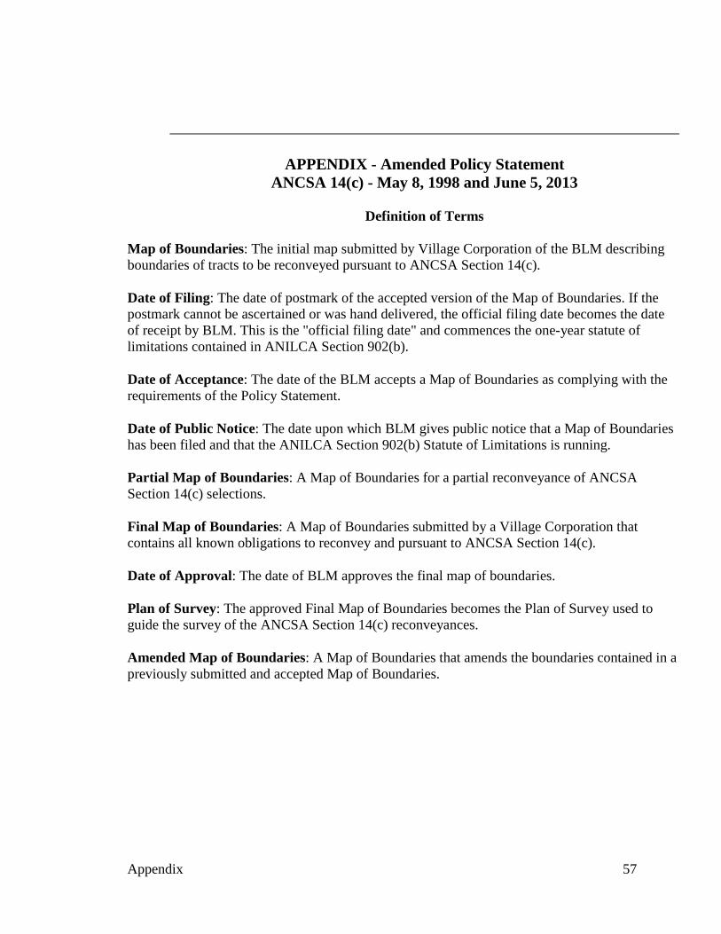
APPENDIX - Amended Policy Statement ANCSA 14(c) - May 8, 1998 and June 5, 2013
Definition of Terms
Map of Boundaries: The initial map submitted by Village Corporation of the BLM describing boundaries of tracts to be reconveyed pursuant to ANCSA Section 14(c).
Date of Filing: The date of postmark of the accepted version of the Map of Boundaries. If the postmark cannot be ascertained or was hand delivered, the official filing date becomes the date of receipt by BLM. This is the "official filing date" and commences the one-year statute of limitations contained in ANILCA Section 902(b).
Date of Acceptance: The date of the BLM accepts a Map of Boundaries as complying with the requirements of the Policy Statement.
Date of Public Notice: The date upon which BLM gives public notice that a Map of Boundaries has been filed and that the ANILCA Section 902(b) Statute of Limitations is running.
Partial Map of Boundaries: A Map of Boundaries for a partial reconveyance of ANCSA Section 14(c) selections.
Final Map of Boundaries: A Map of Boundaries submitted by a Village Corporation that contains all known obligations to reconvey and pursuant to ANCSA Section 14(c).
Date of Approval: The date of BLM approves the final map of boundaries.
Plan of Survey: The approved Final Map of Boundaries becomes the Plan of Survey used to guide the survey of the ANCSA Section 14(c) reconveyances.
Amended Map of Boundaries: A Map of Boundaries that amends the boundaries contained in a previously submitted and accepted Map of Boundaries.
Appendix 57
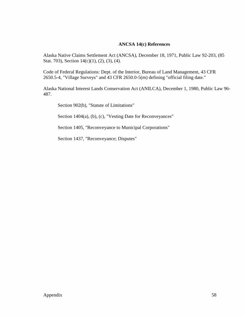
ANCSA 14(c) References
Alaska Native Claims Settlement Act (ANCSA), December 18, 1971, Public Law 92-203, (85 Stat. 703), Section 14(c)(1), (2), (3), (4).
Code of Federal Regulations: Dept. of the Interior, Bureau of Land Management, 43 CFR 2650.5-4, "Village Surveys" and 43 CFR 2650.0-5(m) defining "official filing date."
Alaska National Interest Lands Conservation Act (ANILCA), December 1, 1980, Public Law 96487.
Section 902(b), "Statute of Limitations"
Section 1404(a), (b), (c), "Vesting Date for Reconveyances"
Section 1405, "Reconveyance to Municipal Corporations"
Section 1437, "Reconveyance; Disputes"
Appendix 58
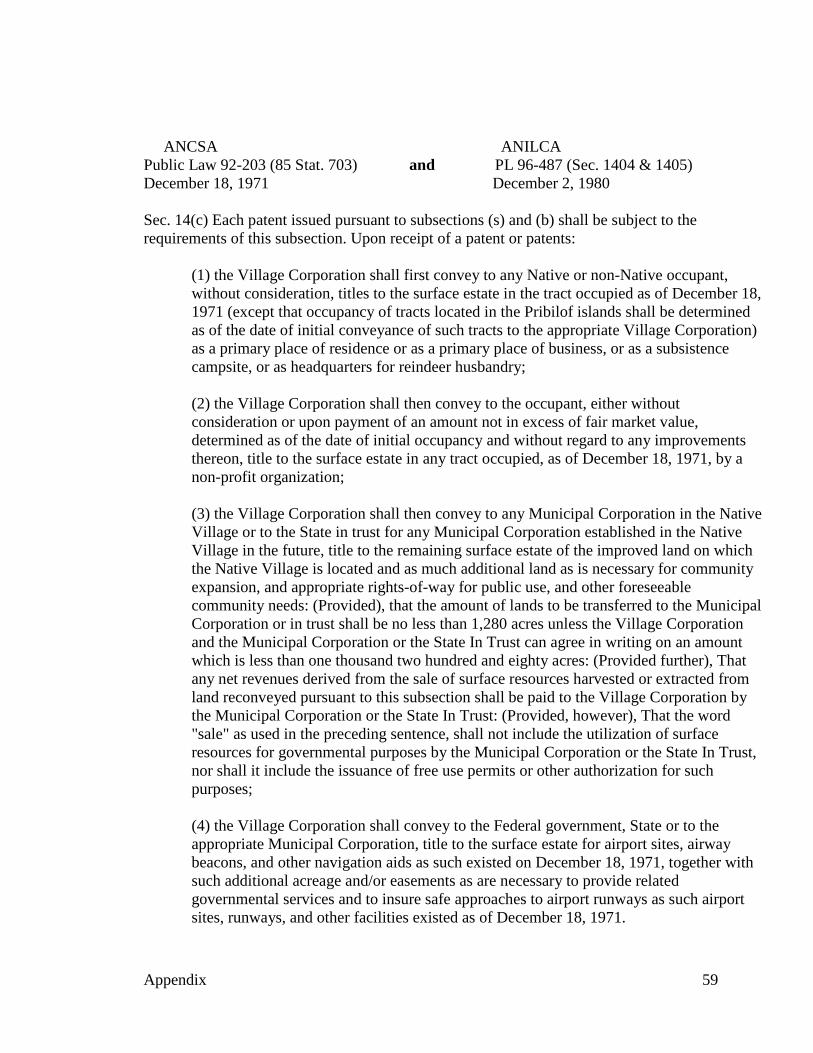
ANCSA ANILCA Public Law 92-203 (85 Stat. 703) and PL 96-487 (Sec. 1404 & 1405) December 18, 1971 December 2, 1980
Sec. 14(c) Each patent issued pursuant to subsections (s) and (b) shall be subject to the requirements of this subsection. Upon receipt of a patent or patents:
(1) the Village Corporation shall first convey to any Native or non-Native occupant, without consideration, titles to the surface estate in the tract occupied as of December 18, 1971 (except that occupancy of tracts located in the Pribilof islands shall be determined as of the date of initial conveyance of such tracts to the appropriate Village Corporation) as a primary place of residence or as a primary place of business, or as a subsistence campsite, or as headquarters for reindeer husbandry;
(2) the Village Corporation shall then convey to the occupant, either without consideration or upon payment of an amount not in excess of fair market value, determined as of the date of initial occupancy and without regard to any improvements thereon, title to the surface estate in any tract occupied, as of December 18, 1971, by a non-profit organization;
(3) the Village Corporation shall then convey to any Municipal Corporation in the Native Village or to the State in trust for any Municipal Corporation established in the Native Village in the future, title to the remaining surface estate of the improved land on which the Native Village is located and as much additional land as is necessary for community expansion, and appropriate rights-of-way for public use, and other foreseeable community needs: (Provided), that the amount of lands to be transferred to the Municipal Corporation or in trust shall be no less than 1,280 acres unless the Village Corporation and the Municipal Corporation or the State In Trust can agree in writing on an amount which is less than one thousand two hundred and eighty acres: (Provided further), That any net revenues derived from the sale of surface resources harvested or extracted from land reconveyed pursuant to this subsection shall be paid to the Village Corporation by the Municipal Corporation or the State In Trust: (Provided, however), That the word "sale" as used in the preceding sentence, shall not include the utilization of surface resources for governmental purposes by the Municipal Corporation or the State In Trust, nor shall it include the issuance of free use permits or other authorization for such purposes;
(4) the Village Corporation shall convey to the Federal government, State or to the appropriate Municipal Corporation, title to the surface estate for airport sites, airway beacons, and other navigation aids as such existed on December 18, 1971, together with such additional acreage and/or easements as are necessary to provide related governmental services and to insure safe approaches to airport runways as such airport sites, runways, and other facilities existed as of December 18, 1971.
Appendix 59
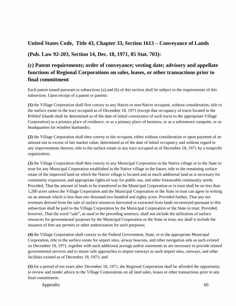
United States Code, Title 43, Chapter 33, Section 1613 – Conveyance of Lands
(Pub. Law 92-203, Section 14, Dec. 18, 1971, 85 Stat. 703):
(c) Patent requirements; order of conveyance; vesting date; advisory and appellate functions of Regional Corporations on sales, leases, or other transactions prior to final commitment
Each patent issued pursuant to subsections (a) and (b) of this section shall be subject to the requirements of this subsection. Upon receipt of a patent or patents:
(1) the Village Corporation shall first convey to any Native or non-Native occupant, without consideration, title to the surface estate in the tract occupied as of December 18, 1971 (except that occupancy of tracts located in the Pribilof Islands shall be determined as of the date of initial conveyance of such tracts to the appropriate Village Corporation) as a primary place of residence, or as a primary place of business, or as a subsistence campsite, or as headquarters for reindeer husbandry;
(2) the Village Corporation shall then convey to the occupant, either without consideration or upon payment of an amount not in excess of fair market value, determined as of the date of initial occupancy and without regard to any improvements thereon, title to the surface estate in any tract occupied as of December 18, 1971 by a nonprofit organization;
(3) the Village Corporation shall then convey to any Municipal Corporation in the Native village or to the State in trust for any Municipal Corporation established in the Native village in the future, title to the remaining surface estate of the improved land on which the Native village is located and as much additional land as is necessary for community expansion, and appropriate rights-of-way for public use, and other foreseeable community needs: Provided, That the amount of lands to be transferred to the Municipal Corporation or in trust shall be no less than 1,280 acres unless the Village Corporation and the Municipal Corporation or the State in trust can agree in writing on an amount which is less than one thousand two hundred and eighty acres: Provided further, That any net revenues derived from the sale of surface resources harvested or extracted from lands reconveyed pursuant to this subsection shall be paid to the Village Corporation by the Municipal Corporation or the State in trust: Provided, however, That the word “sale”, as used in the preceding sentence, shall not include the utilization of surface resources for governmental purposes by the Municipal Corporation or the State in trust, nor shall it include the issuance of free use permits or other authorization for such purposes;
(4) the Village Corporation shall convey to the Federal Government, State, or to the appropriate Municipal Corporation, title to the surface estate for airport sites, airway beacons, and other navigation aids as such existed on December 18, 1971, together with such additional acreage and/or easements as are necessary to provide related governmental services and to insure safe approaches to airport runways as such airport sites, runways, and other facilities existed as of December 18, 1971; and
(5) for a period of ten years after December 18, 1971, the Regional Corporation shall be afforded the opportunity to review and render advice to the Village Corporations on all land sales, leases or other transactions prior to any final commitment.
Appendix 60
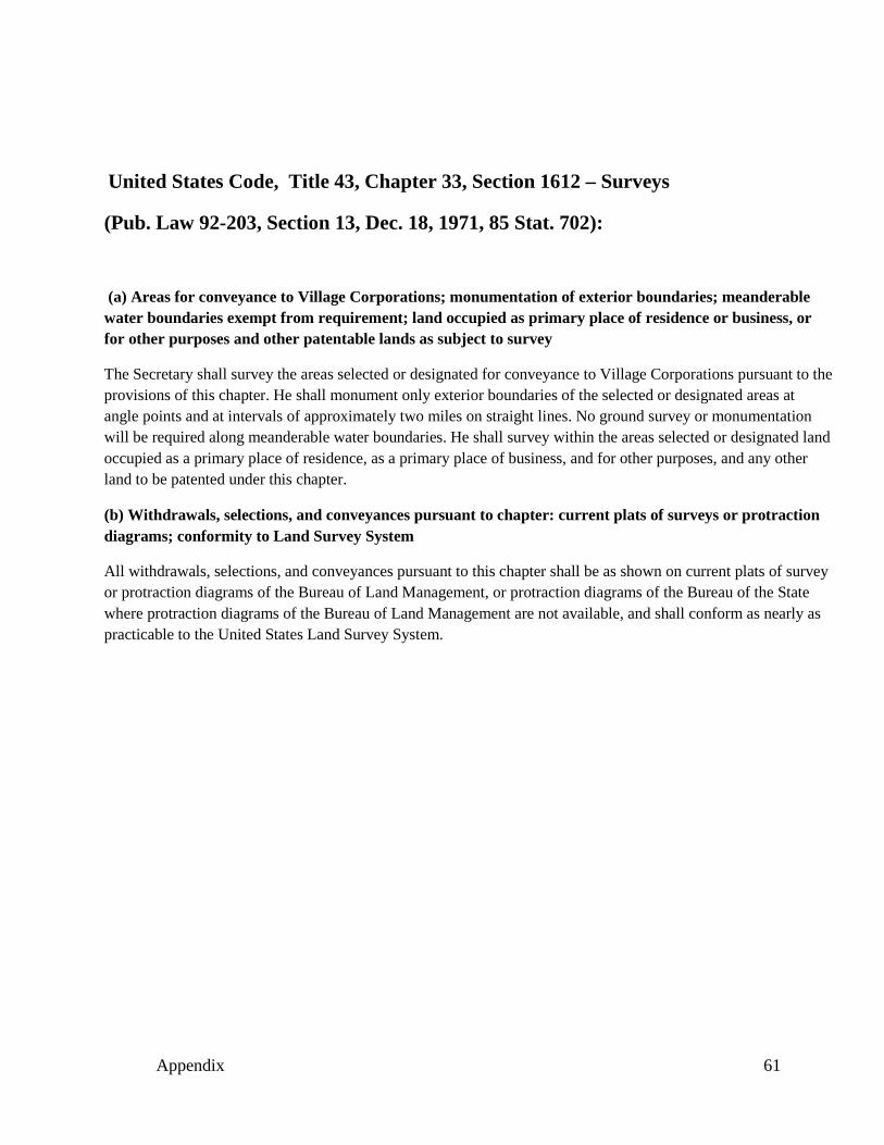
United States Code, Title 43, Chapter 33, Section 1612 – Surveys
(Pub. Law 92-203, Section 13, Dec. 18, 1971, 85 Stat. 702):
(a) Areas for conveyance to Village Corporations; monumentation of exterior boundaries; meanderable water boundaries exempt from requirement; land occupied as primary place of residence or business, or for other purposes and other patentable lands as subject to survey
The Secretary shall survey the areas selected or designated for conveyance to Village Corporations pursuant to the provisions of this chapter. He shall monument only exterior boundaries of the selected or designated areas at angle points and at intervals of approximately two miles on straight lines. No ground survey or monumentation will be required along meanderable water boundaries. He shall survey within the areas selected or designated land occupied as a primary place of residence, as a primary place of business, and for other purposes, and any other land to be patented under this chapter.
(b) Withdrawals, selections, and conveyances pursuant to chapter: current plats of surveys or protraction diagrams; conformity to Land Survey System
All withdrawals, selections, and conveyances pursuant to this chapter shall be as shown on current plats of survey or protraction diagrams of the Bureau of Land Management, or protraction diagrams of the Bureau of the State where protraction diagrams of the Bureau of Land Management are not available, and shall conform as nearly as practicable to the United States Land Survey System.
Appendix 61
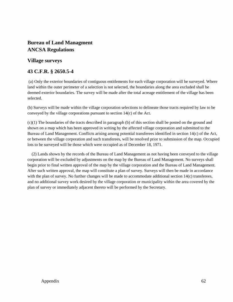
Bureau of Land Managment ANCSA Regulations
Village surveys
43 C.F.R. § 2650.5-4
(a) Only the exterior boundaries of contiguous entitlements for each village corporation will be surveyed. Where land within the outer perimeter of a selection is not selected, the boundaries along the area excluded shall be deemed exterior boundaries. The survey will be made after the total acreage entitlement of the village has been selected.
(b) Surveys will be made within the village corporation selections to delineate those tracts required by law to be conveyed by the village corporations pursuant to section 14(c) of the Act.
(c)(1) The boundaries of the tracts described in paragraph (b) of this section shall be posted on the ground and shown on a map which has been approved in writing by the affected village corporation and submitted to the Bureau of Land Management. Conflicts arising among potential transferees identified in section 14(c) of the Act, or between the village corporation and such transferees, will be resolved prior to submission of the map. Occupied lots to be surveyed will be those which were occupied as of December 18, 1971.
(2) Lands shown by the records of the Bureau of Land Management as not having been conveyed to the village corporation will be excluded by adjustments on the map by the Bureau of Land Management. No surveys shall begin prior to final written approval of the map by the village corporation and the Bureau of Land Management. After such written approval, the map will constitute a plan of survey. Surveys will then be made in accordance with the plan of survey. No further changes will be made to accommodate additional section 14(c) transferees, and no additional survey work desired by the village corporation or municipality within the area covered by the plan of survey or immediately adjacent thereto will be performed by the Secretary.
Appendix 62
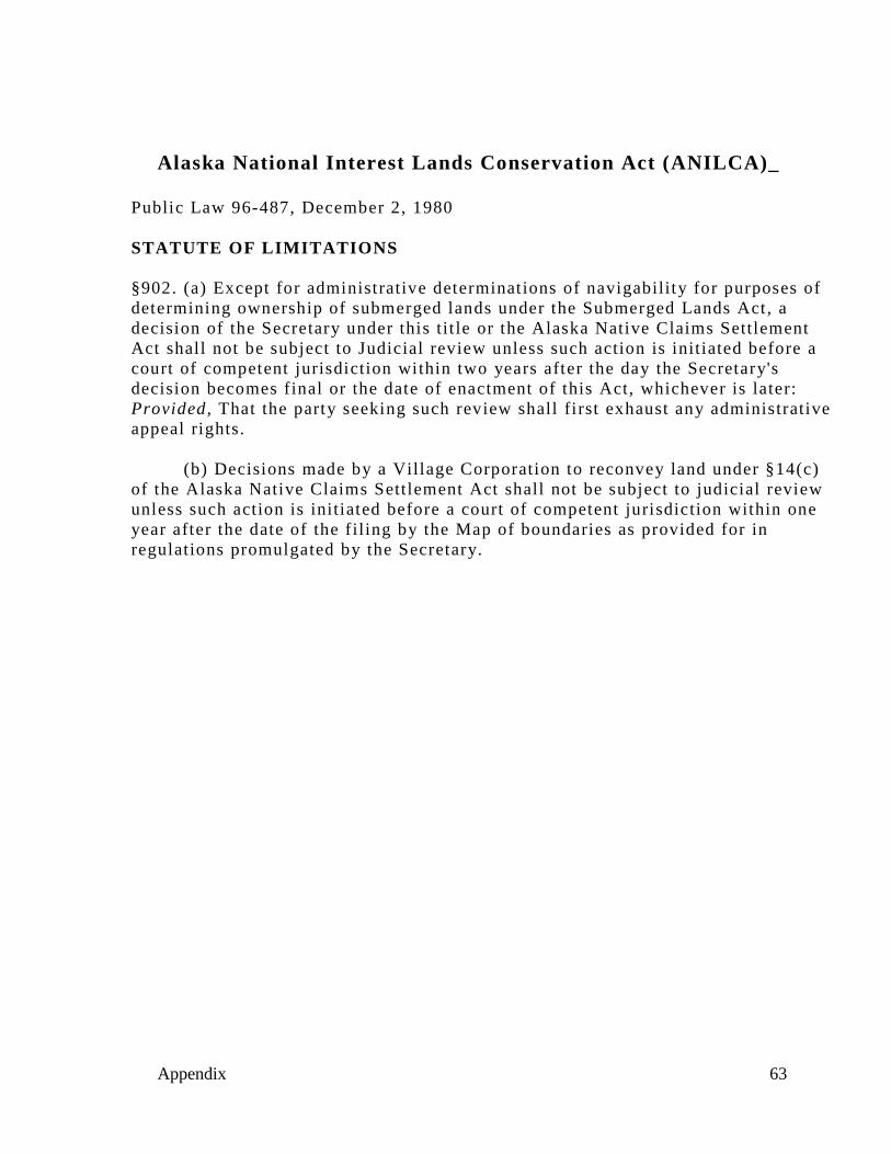
Alaska National Interest Lands Conservation Act (ANILCA)_
Public Law 96-487, December 2, 1980
STATUTE OF LIMITATIONS
§902. (a) Except for administrative determinations of navigability for purposes of determining ownership of submerged lands under the Submerged Lands Act, a decision of the Secretary under this tit le or the Alaska Native Claims Settlement Act shall not be subject to Judicial review unless such action is initiated before a court of competent jurisdiction within two years after the day the Secretary's decision becomes final or the date of enactment of this Act, whichever is later: Provided , That the party seeking such review shall first exhaust any administrative appeal rights.
(b) Decisions made by a Village Corporation to reconvey land under §14(c) of the Alaska Native Claims Settlement Act shall not be subject to judicial review unless such action is initiated before a court of competent jurisdiction within one year after the date of the filing by the Map of boundaries as provided for in regulations promulgated by the Secretary.
Appendix 63
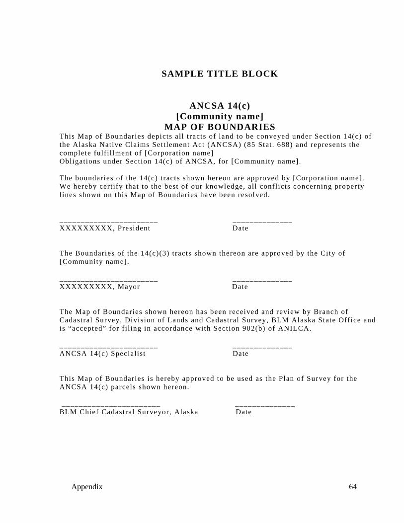
_______________________ ______________
_______________________ ______________
_______________________ ______________
_______________________ ______________
SAMPLE TITLE BLOCK
ANCSA 14(c) [Community name]
MAP OF BOUNDARIES This Map of Boundaries depicts al l tracts of land to be conveyed under Section 14(c) of the Alaska Native Claims Sett lement Act (ANCSA) (85 Stat . 688) and represents the complete fulfi l lment of [Corporation name] Obligations under Section 14(c) of ANCSA, for [Community name] .
The boundaries of the 14(c) tracts shown hereon are approved by [Corporation name]. We hereby cert ify that to the best of our knowledge, al l conflicts concerning property l ines shown on this Map of Boundaries have been resolved.
XXXXXXXXX, President Date
The Boundaries of the 14(c)(3) tracts shown thereon are approved by the City of [Community name].
XXXXXXXXX, Mayor Date
The Map of Boundaries shown hereon has been received and review by Branch of Cadastral Survey, Division of Lands and Cadastral Survey, BLM Alaska State Office and is “accepted” for f i l ing in accordance with Section 902(b) of ANILCA.
ANCSA 14(c) Specialist Date
This Map of Boundaries is hereby approved to be used as the Plan of Survey for the ANCSA 14(c) parcels shown hereon.
BLM Chief Cadastral Surveyor, Alaska Date
Appendix 64
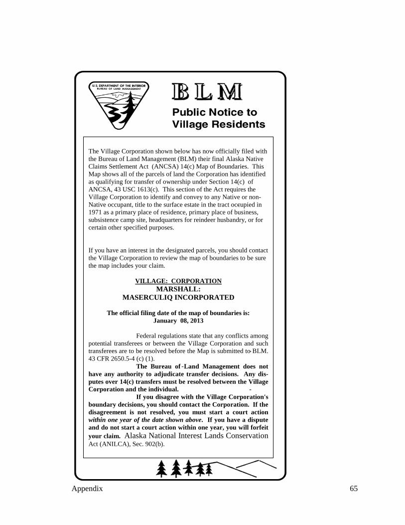
The Village Corporation shown below has now officially filed with the Bureau of Land Management (BLM) their final Alaska Native Claims Settlement Act (ANCSA) 14(c) Map of Boundaries. This Map shows all of the parcels of land the Corporation has identified as qualifying for transfer of ownership under Section 14(c) of ANCSA, 43 USC 1613(c). This section of the Act requires the Village Corporation to identify and convey to any Native or nonNative occupant, title to the surface estate in the tract occupied in 1971 as a primary place of residence, primary place of business, subsistence camp site, headquarters for reindeer husbandry, or for certain other specified purposes. If you have an interest in the designated parcels, you should contact the Village Corporation to review the map of boundaries to be sure the map includes your claim.
VILLAGE: CORPORATION MARSHALL:
MASERCULIQ INCORPORATED
The official filing date of the map of boundaries is: January 08, 2013
Federal regulations state that any conflicts among potential transferees or between the Village Corporation and such transferees are to be resolved before the Map is submitted to BLM. 43 CFR 2650.5 4 (c) (1). The Bureau of Land Management does not have any authority to adjudicate transfer decisions. Any disputes over 14(c) transfers must be resolved between the Village Corporation and the individual. If you disagree with the Village Corporation's boundary decisions, you should contact the Corporation. If the disagreement is not resolved, you must start a court action within one year of the date shown above. If you have a dispute and do not start a court action within one year, you will forfeit your claim. Alaska National Interest Lands Conservation Act
The Village Corporation shown below has now officially filed with the Bureau of Land Management (BLM) their final Alaska Native Claims Settlement Act (ANCSA) 14(c) Map of Boundaries. This Map shows all of the parcels of land the Corporation has identified as qualifying for transfer of ownership under Section 14(c) of ANCSA, 43 USC 1613(c). This section of the Act requires the Village Corporation to identify and convey to any Native or non
-Native occupant, title to the surface estate in the tract occupied in 1971 as a primary place of residence, primary place of business, subsistence camp site, headquarters for reindeer husbandry, or for certain other specified purposes.
If you have an interest in the designated parcels, you should contact the Village Corporation to review the map of boundaries to be sure the map includes your claim.
VILLAGE: CORPORATION MARSHALL:
MASERCULIQ INCORPORATED
The official filing date of the map of boundaries is: January 08, 2013
Federal regulations state that any conflicts among potential transferees or between the Village Corporation and such
-transferees are to be resolved before the Map is submitted to BLM. 43 CFR 2650.5-4 (c) (1).
-The Bureau of Land Management does not have any authority to adjudicate transfer decisions. Any disputes over 14(c) transfers must be resolved between the Village Corporation and the individual.
If you disagree with the Village Corporation's boundary decisions, you should contact the Corporation. If the disagreement is not resolved, you must start a court action within one year of the date shown above. If you have a dispute and do not start a court action within one year, you will forfeit your claim. Alaska National Interest Lands Conservation Act (ANILCA), Sec. 902(b).
Appendix 65
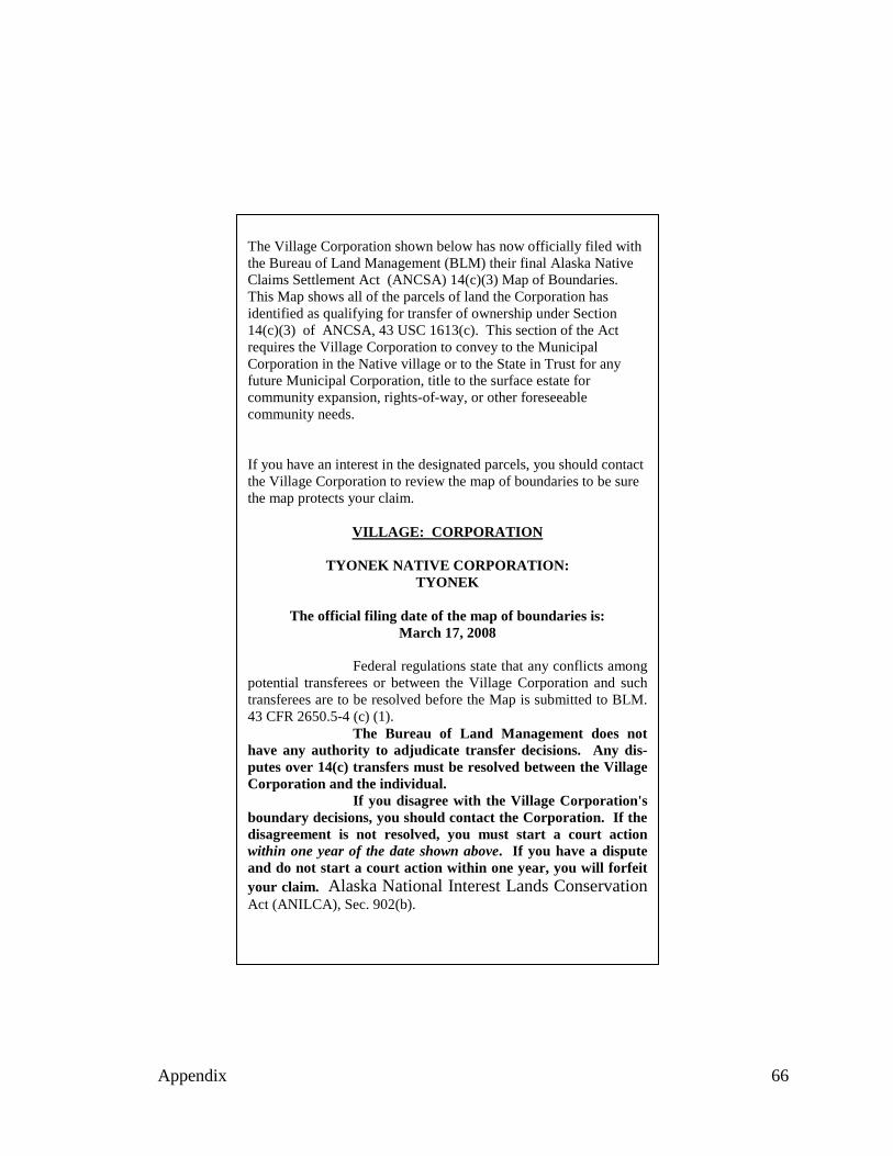
The Village Corporation shown below has now officially filed with the Bureau of Land Management (BLM) their final Alaska Native Claims Settlement Act (ANCSA) 14(c)(3) Map of Boundaries. This Map shows all of the parcels of land the Corporation has identified as qualifying for transfer of ownership under Section 14(c)(3) of ANCSA, 43 USC 1613(c). This section of the Act requires the Village Corporation to convey to the Municipal Corporation in the Native village or to the State in Trust for any future Municipal Corporation, title to the surface estate for community expansion, rights-of-way, or other foreseeable community needs.
If you have an interest in the designated parcels, you should contact the Village Corporation to review the map of boundaries to be sure the map protects your claim.
VILLAGE: CORPORATION
TYONEK NATIVE CORPORATION: TYONEK
The official filing date of the map of boundaries is: March 17, 2008
Federal regulations state that any conflicts among potential transferees or between the Village Corporation and such transferees are to be resolved before the Map is submitted to BLM. 43 CFR 2650.5-4 (c) (1).
The Bureau of Land Management does not have any authority to adjudicate transfer decisions. Any disputes over 14(c) transfers must be resolved between the Village Corporation and the individual.
If you disagree with the Village Corporation's boundary decisions, you should contact the Corporation. If the disagreement is not resolved, you must start a court action within one year of the date shown above. If you have a dispute and do not start a court action within one year, you will forfeit your claim. Alaska National Interest Lands Conservation Act (ANILCA), Sec. 902(b).
Appendix 66