Embed Size (px)
Citation preview

DOCUMENT RESUME
ED 384 553 SO 024 877
AUTHOR Blankenship, Glen; Tinkler, D. WilliamTITLE The Geography of Germany: Lessons for Teaching the
Five Themes of Geography.PUB DATE 93
NOTE 95p.; For related volume of social studies lessons,see SO 024 876.
PUB TYPE Guides Classroom Use Teaching Guides (ForTeacher) (052)
EDRS PRICE MF01/PC04 Plus Postage.DESCRIPTORS Area Studies; Elementary Secondary Education; Foreign
Countries; Fundamental Concepts; *GeographicConcepts; Geographic Location; *Geography; *GeographyInstruction; History; Human Geography; PhysicalGeography; Social Studies; Teaching Guides; TeachingMethods; Western Civilization
IDENTIFIERS *Germany
ABSTRACTThis activity guide contains five lessons. Lesson 1
deals with "Location of Germany on the Earth's Surface" with twoactivities: (1) "Germany's Location in the World"; and (2) "Germany'sLocation in Europe." Lesson 2 is on the "Physical and HumanCharacteristics of Germany" with four activities on: (1) "PhysicalFeatures of Germany"; (2) "Germany's Population Pyramid"; (3)
" Population Density in Germany"; and (4) "Population Distribution inGermany." Lesson 3 addresses "The Interaction of the German Peopleand Their Environment" with four activities: (1) "Land Use inGermany"; (2) "Industrial Areas in Germany"; (3) "Pollution inGermany"; and (4) "The Environment." Lessc- 4 highlights "Movementand Diversity in Germany" with two activities: (1) "Foreigners inGermany"; and (2) "Immigration to Germany." Lesson 5 develops thetheme of "German Unification and Regional Changes" with aixactivities: (1) "Regions in Germany"; (2) "German Unification"; (3)
"Opening the Berlin Wall"; (4) "East German Perspectives onUnification, Part A"; (5) "East German Perspectives on Unification,Part B"; and (6) "World Press Views on Unification." Completehandouts and instruc'tions accompany the lessons. The volume alsoincludes a series of overhead transparencies. (EH)
************************************************************************ Reproductions supplied by EDRS are the best that can be made *
* from the original document.***********************************************************************

Lessons for Teaching theFive Themes of Geography
Social Studies LessonsWritten and Developed by
Glen BlankenshipD. William Tinkler
BEST COPY AVAILABLE
U.S DEPARTMENT OF EDUCATIONOtbce of Educational Research and improvement
EDUCATIONAL RESOURCES INFORMATION
\f5yCENTER (ERIC)
This document has been reproduced asreceived from the Person or organizationoriginating .1
0 Mrnor changes bare been made to improvereproduClinn Quality
Points of mew or opimons staled in tfus document do not necessarily represent officialOE RI poSthon or policy
"PERMISSION TO REPRODUCE THISMATERIAL HAS BEEN GRANTED BY
TO THE EDUCATIONAL RESOURCESINFORMATION CENTER (ERIC).-

Glen Blankenship, co-author of the lessons, is Instruction Coordinator of Social Studiesfor the Gwinnett County Georgia, Public Schools. In addition to his work in the field ofcurriculum development and teacher education, Dr. Blankenship is a frequent presenterto civic and educational organizations across the nation. Dr. Blankenship earned hisB.A. and M.Ed. in Political Science from Georgia State University, and a Ph. D. fromEmory University.
D. William rink ler, co-author of the lessons, is a middle school assistant principal forthe Fulton County Georgia, School System. Dr. Tink ler is active in his state's socialstudies professional organization, LJrving as president in 1993. He has also assistedin the writing of course guide and instructional materials on special topics. Graduatingcum laude with a B.A. in Political Science from Duke University, Dr. Tink ler earned hisEd.D. from the University of Georgia.
Page 19Page 40Pages 70, 71, 72. -
Globus Kartendienst 8600Globus Kartendienst 4380Associated Press, Frankfurt/Main
Copyright 1993 byInter NationesKennedyallee 91-103D-53175 BonnFederal Republic of Germany
Table of Contents
Lesson Title Page
Lesson One: Location of Germany on the Earth's Surface 1
Activity 1 Germany's Location in the WorldActivity 2 Germany's Location in Europe
Lesson Two: Physical and Human Characteristics of Germany 9.-tivity 1 Physical Features of Germany
Activity 2Activity 3Activity 4
GermanyS Population PyramidPopulation Density in GermanyPopulation Distribution in Germany
Lesson Three: The Interaction of the German People and Their Environment 25Activity 1 Land Use in Germany
Lesson Four:
Lesson Five:
Activity 2Activity 3Activity 4
Industrial Areas in GermanyPollution in GermanyThe Environment
Movement and Diversity in GermanyActivity 1 Foreigners in GermanyActivity 2 Immigration to Germany
German Unification and Regional ChangesActivity 1 Regions in GermanyActivity 2 German UnificationActivity 3Activity 4Activity 5Activity 6
Opening the Berlin WallEast German Perspectives on Unification, Part AEast German Perspectives on Unification, Part BWorld Press Views on Unification
47
55
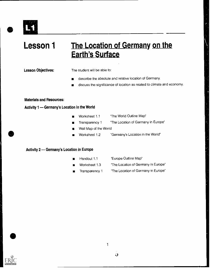
Lesson 1 The Location of Germany on theEarth's Surface
Lesson Objectives: The student will be able to:
describe the absolute and relative location of Germany.
discuss the significance of location as related to climate and economy.
Materials and Resources:
Activity 1 Germany's Location in the World
Worksheet 1.1 The World Outline Map"
Transparency 1 The Location of Germany in Europe"
Wall Map of the World
Worksheet 1.2 "Germany's Location in the World"
Activity 2 Germany's Location in Europe
Handout 1.1 "Europe Outline Map"
Worksheet 1.3 "The Location of Germany in Europe"
Transparency 1 "The Location of Germany in Europe"
1
ACTIVITIES
Activity 1 Germany's Location in the WorldGermany is a nation located in the geographical
.center of Europe with doors that open both eastand west. Germany shares a border with more na-tions (nine) than any other nation in Europe. Dis-tribute copies of the world map (Worksheet 1.1).Using Transparency 1 and a large, pull-downworld map, show students the location of Ger-many and ask them to mark it on their maps. Be-cause all wall maps found in schools may not yetshow one Germany, explain that from 1949 to1990 Germany was divided into two parts: West(Federal Republic of Germany) and East (GermanDemocratic Republic). Discuss the location of Ger-many relative to the United States and to yourstate. For example, examine latitudes which crossboth Germany and North America. Discuss stu-dent impressions of what types of climatic charac-teristics are associated with these latitudes.Students should note, for example, that althoughGermany is at a higher latitude than the UnitedStates the climate is moderate year-round due tothe Gulf Stream.
Distribute Worksheet 1.2 "Germany's Location inthe World° to reinforce class discussion. A wallmap will be needed to complete the activity alongwith crayons, color pencils, or markers.
Activity 2 Germany's Location in EuropePhysical location of a nation within a region can
have significant political, economic and social/cul-tural implications. To establish the relationship be-tween Germany and her neighbors, distributecopies of Handout 1.1 "Europe Outline Map" andhelp students locate and label Germany in thecenter of Europe by using Transparency 1. Assignstudents to work in groups of two or three to com-plete the map and Worksheet 1.3, "The Location ofGermany in Europe." When students have com-pleted the activity sheet, discuss responses andthe importance of geographic location for acountry with regard to trade and transportation.
2

133 Activity 1 Worksheet 1.1
The World Outline Map

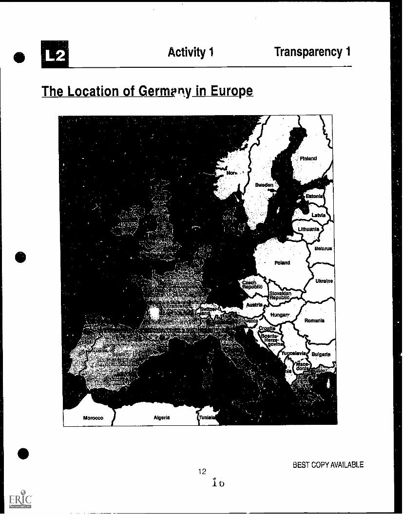
LI Activity 1 Transparency 1
The Location of Germany in Europe
t "al
00#4,
--
Morocco Algeria flanhul
4
Norway
Sweden
alibi,lc
Austria
Poland
SlovakianRepublic
Finland
Eaton
Latvia
Lithuania
Belarue
Ukraine
Hungaryla Romania
Hefa-
n
1ev
adon
a
Bulgaria
BEST COPY AVAILABLE
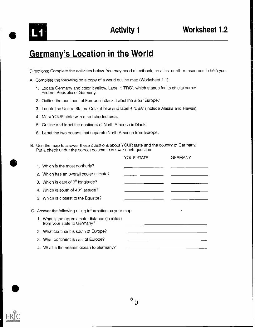
Ll Activity 1 Worksheet 12
Germany's Location in the World
Directions: Complete the activities below. You may need a textbook, an atlas, or other resources to help you.
A. Complete the following on a copy of a world outline map (Worksheet 1.1).
1. Locate Germany and color it yellow. Label it "FRG", which stands for its official name:Federal Republic of Germany.
2. Outline the continent of Europe in black. Label the area "Europe."
3. Locate the United States. Cobr it blue and label it "USA" (include Alaska and Hawaii).
4. Mark YOUR state with a red shaded area.
5. Outline and label the continent of North America in black.
6. Label the two oceans that separate North America from Europe.
B. Use the map to answer these questions about YOUR state and the country of Germany.Put a check under the correct column to answer each question.
YOUR STATE GERMANY
1. Which is the most northerly?
2. Which has an overall cooler climate?
3. Which is east of 0° longitude?
4. Which is south of 40° latitude?
5. Which is closest to the Equator?
C. Answer the following using information on your map.
1. What is the approximate distance (in miles)from your state to Germany?
2. What continent is south of Europe?
3. What continent is east of Europe?
4. What is the nearest ocean to Germany?
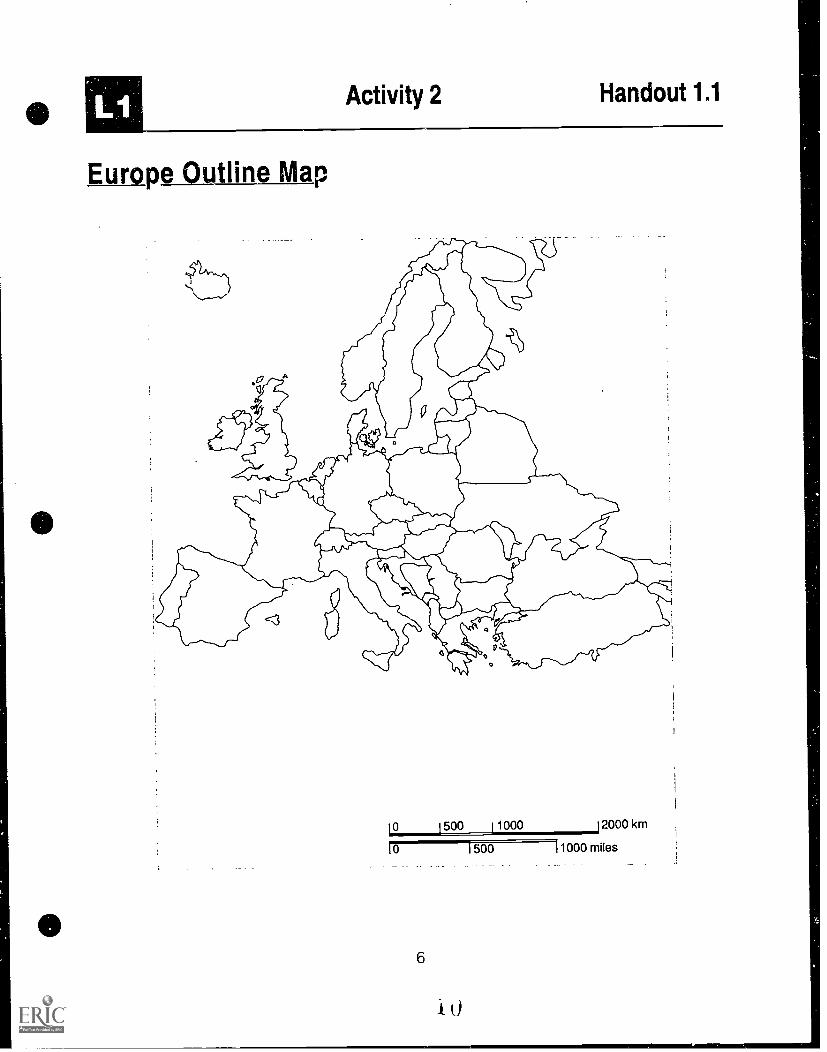
Activity 2 Handout 1.1
Etimpe_autline Map
10 1500 11000 12000 km
0 500 11000 miles
6

L1 Activity 2 Worksheet 1.3
The Location of Germany in Europe
Directions: Use otner maps as a reference in order to complete this worksheet and label the outline map ofEurope (Handout 1.1).1. Label Germany in Central Europe. Explain to students that Germany has a Ind area of about 357,000
square kilometers. (249,000 km2 for former West Germany and 108,000 km for former East Germany.)In comparison: Great Britain 244,000 km2
Italy 301.000 km2France 547.000 km2.
From east to west Germany is 632 km at its widest point. From north to south the greatest length is 876 km.
2. Shade all countries that are a part of the European Community (EC). Use Transparency 1 as a guide(member countries are shown in light green except for Germany which is shown in dark green). Euro-pean countries that are not members of the EC are shown in gray; North African countries are shown inyellow). This group of countries is an association that has agreed to create a single market for goods andservices in Western Europe in 1993. The free circulation of goods and people would be allowed betweenthese countries. The countries you should shade are: Belgium. Denmark. France. Germany. Greece. Ire-land. Italy. Luxembourg. Netherlands. Portugal. Spain. United Kingdom.
3 Label all the countries that border the Federal Republic of Germany. They are:Denmark Poland Czech Republic Austria SwitzerlandFrance Belgium Netherlands Luxembourg
The country sharing the longest border with Germany is Austria (784 km). Use the scale to identify thecountry showing the shortest boundary.Which nations share boundaries over 400 km?
4. Label the bodies of water that give a seacoast to the Federal Republic of Germany. They are the BalticSea and the North Sea.
5. Describe the location of Germany as related to other European countries and the EC countries
6 What advantages to trade and transportation would Germany's location have?
7 What disadvantages might Germanys location have?
7
11

Activity 2 Transparency 1
The Location of Germany in Europe
s'r
SPii1W, r
-',
Morocco Algeria IbnIsi
8
Sweden
'chCzeRepublic
,
Poland
SlovaloymRepuL..:
Austria
Hungary0:4...lhave la
nle-
- p jset.,
- Horse-..
r
Finland
Estonia
Latvia
Lithuania
Belarus
Ukraine
Romania
oslavia Bulgaria
ace -
la la r
Gr:",
BEST COP" AVAILABLE
L2
Lesson 2 Physical and HumanCharacteristics of Germany
Lesson Objectives: The student will be able to:
describe the major physical features of Germany.
interpret graphs and tables summarizing popuiation data on Germany.
analyze selected population data on Germany as it relates to other na-
tions.
Materials and Resources:
Activity 1 Physical Features of Germany
Transparency 1 The Location of Germany in Europe"
Transparency 2 "Landforms, Rivers and Canals"
Transparency 3 "Important Industrial Areas and Location of
Mineral Resources"
Transparency 4 "Types of Industries"
Worksheet 2.1 The Four Major Landforms of Germany"
Teacher Resource 2.1 The Four Major Landforms of Germany"
Teacher Resource 2.2 "Rivers and Canals in Germany"
Activity 2 Germany's Population Pyramid
Handout 2.1 The German Population Tree"
Teacher Resource 2.3 "Population Data on Germany"
Activity 3 Population Density in Germany
Transparency 5* "Population Density"
Activity 4 Population Distribution in Germany
Worksheet 2.2
Handout 2.2
Note: The population figure on Tansparency 5 for thethree states Alabama, Georgia and South Carolinashould be 14.1 million, rather than 114 million.
9
13
"Outline Map of Germany"
"Population Density in the German States"
ACTIVITIES
Activity 1 Physical Features of GermanyGermany's physical features and natural re-
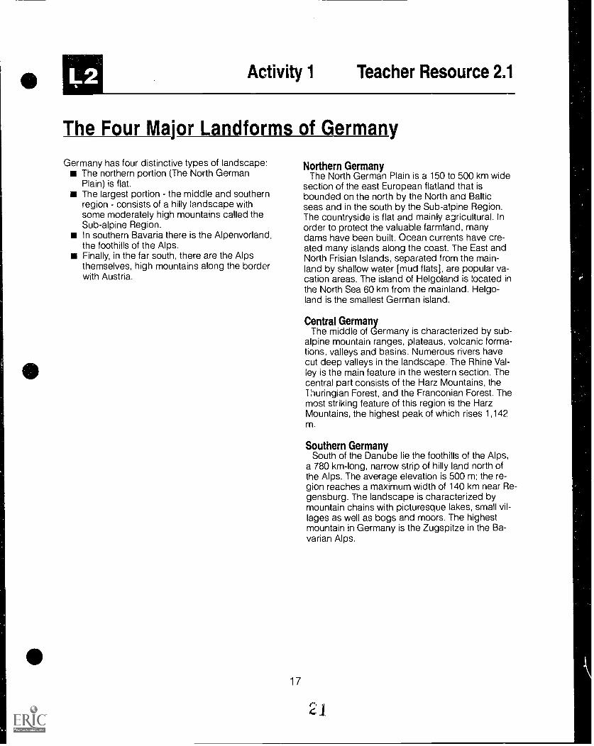
sources have contributed greatly to its industrialdevelopment and population increase. ShowTransparency 2 and discuss with students the fourmajor landforms of Germany. Then, divide theclass into groups of four students and have themcomplete Worksheet 2.1 "The Four Major Land-forms of Germany," writing framed paragraphsand answering the summary questions at the end.Randomly call on students to read the group'sparagraph on one of the landforms and explainthe significance of each as related to populationand industry. The teacher may use Teacher Re-source 2.1 as a key to this activity.
In the whole class discussion that summarizesthis activity the teacher can pose the followingquestions:
0-Besides landforms, what other information isimportant in determining the distribution ofpopulation throughout Germany?
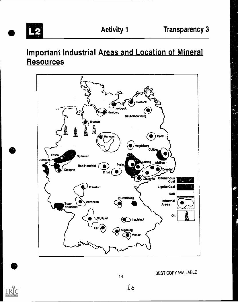
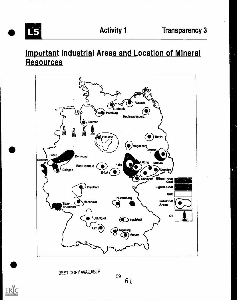
A-Factors m;ght include the location and flow ofrivers (see Transparency 2), mineral deposits(see Transparency 3), strategic global locationfor commercial airline flights (see Transparency1) and industrial centers (see Transparency 4).
0-How do some of these factors affect economicdevelopment and population distributions inGermany?
A-Al! the rivers which have been named on themap are navigable. The combined length of allthe regularly traveled waterways is 6,700 km(4,400 along rivers and 2,300 on the seas).Rivers and canals are very important for theGerman economy. Almost a fourth of all Ger-man goods are shipped by water. Eighty per-cent of all the goods in Germany that areshipped by water are transported on the Rhine.As expected, population density is highestalong the banks of this river. [See Teacher Re-source 2.2 "Rivers and Canals in Germany" forfurther information.]
Activity 2 Germany's Population PyramidPopulation growth and age distribution are im-
portant to a country's need for human capital andsupport of welfare programs (e.g., health and so-cial security). Ask students to speculate about theimpact on a community's population of each of thefollowing:
a. Many people marry at a young age and havefive or six children. This goes on for severalgenerations. (The population will grow dra-matically.)
b. Many people delay marriage and child rear-ing until they are in their 30's. As a result, theaverage size family includes less than twochildren per couple. (If sustained, the popula-tion would decline.)
c. The country goes to war, many are killed,especially young men called to serve in themilitary. (A decrease among certain agegroups and males occurs disrupting the nor-mal population distribution.)
Project a transparency of Handout 2.1 "The Ger-man Population Tree." The age distribution of thepopulation in the western section and the easternsection is not the same. In West Germany in 1988only 14.7% of the population was under 15 yearsold, and 15.3% over 65 years old. In East Ger-many 19.4% of the population was under 15 yearsold and 14.1% over 65 years old. East Germany'sbirthrate did not decline as much as West Germa-ny's, which is the lowest in the world. Cover theyears 1988 and 2040. Ask students to interpretwhat the 1910 population tree shows (a typicaldeveloping nation population pyramid with a highbirth rate and fairly low life expectancy).
Uncover the 1988 graph and ask students tocompare it to the 1910 graph. It shows the impactof two world wars and a decrease in the birth rate.Note the greater number of older females. Ask stu-dents to project ahead. If trends continue, whatwill the graph look like in the 21st century?
Uncover the 2040 graph. Are the students'speculations correct?

L2
What are the implications of these potentialchanges for each of the following:
overall size of the populationeducationsocial welfare for older citizenseconomic development
Additional data about population in Germanycan be found in Teacher Resource 2.3 "PopulationData on Germany"
Activity 3 Population Density in GermanyMark off an area on the classroom floor approxi-
mately 6 feet by 6 feet in size. Explain that this rep-resents the combined area of the states ofAlabama, Georgia and South Carolina. Ask threestudents to stand in this area and explain that thisrepresents the population of the three states (ap-proximately 14.1 million people). Now add fifteenmore students to the same area. Explain that thisrepresents the population of Germany (78.4 millionpeople) in the same amount of land.
For comparative purposes, refer students toTransparency 5 "Population Density" which com-pares Germany with the three-state region of Ala-bama, Georgia and South Carolina. (Note: Thisactivity may be repeated using the state of Mon-tana, a state geographically the same size as Ger-many but much smaller in population.)*
To verify which country or region is the mostcrowded, compute the population density of each.To do this, simply divide the population by thearea. This will provide the number of people persquare mile:
Population/Area = Population DensityThe teach- r can then ask the class to list at least
two advantages of living in a place with a highpopulation density. Then, as a follow up, theteacher should have students list at least two dis-advantages of living in a place with a high popula-tion density.
Note- The population figure on Transparency 5 for thethree states Alabama, Georgia and South Carolinashould be 14.1 million, rather than 114 million.
11
Activity 4 Population Distribution in GermanyIn former West Germany almost 40% of the
population live in the larger cities of over 100,000inhabitants. Only 6% live in communities of 2,000or less. In former East Germany 27% of the popu-lation live in the 15 largest cities (population100,000 or more) and 23.5% in communities of2,000 or less. To show the population distributionin Germany, give students Worksheet 2.2 "OutlineMap of Germany," as well as Handout 2.2 "Popula-tion Density in the German States" and ask themto shade the map reflecting patterns of populationdensity. When completed, ask students to explainthe patterns of population density in reference tothose factors discussed in Activity 1 above: loca-tion/flow of rivers (Transparency 2), mineral de-posits (Transparency 3), strategic location forairlines (Transparency 1) and industrial centers(Transparency 4).
1
L2 Activity 1 Transparency 1
The Location of Germeny in Europe
Morocco Algeria ThnlsI
12
to
N011,
Sweden
'ts
CzechRepublic
Poland
SlovakianRepublic
Finland
'Estonia
Latvia
Lithuania
Beisrus
Ukraine
Austria
Hungarrvs la Romania
a
Newawn
lavia Bulgaria- -0
CI`don
BEST COPY AVAILABLE

L2 Activity 1 Transparency 2
Landforms, Rivers and Canals
Oder-Spreenal
North GermanPlain
Sub-alpineRegion
Foothillsof the Alps
13
17BEST COPY AVAILABLE
Activity 1 Transparency 3
Important Industrial Areas and Location of MineralResources
Essen
Duisburg
CologneCologne
Bremen
Dortmund
LuebeckHamburg
Hanove
Bad Hersfeld k
Erfurt
Saar-bruecken
Frankfurt
Mannheim
41° StuttgartUlm
Halle0
Neubrandenburg
0Magdeburg
Nuremberg
Cb
Leipzig Mean
eiPChemnitz Bituminous
Coal
Lignite Coal
Salt
IndustrialAreas
onngoistadt
Augsburg
(c)I Munich
14
13
BEST COPY AVAILABLE

Activity 1 Transparency 4
Types of Industries
The Ruhr Region
1.46. Shipbuilding
Iron and Steel
6, Industry
Electrical Industry
00 Chemical Industry
Mining
Or Truck Manufacturing
Automobile4okip Manufacturing
15
JEST COPY AVAILABLE

12 Activity 1 Worksheet 2.1
The Four Major Landforms of Germany
The North German Plain is a section of the east European flatland that
The middle of Germany is characterized by
South of the Danube lie the foothills of the
In the extreme south of Germany lie the picturesque
Questions:
Based on physical features alone,in which area of Germany would one most likely find:
1. the highest density of population?
2. agriculture as a main economic activity?
3. skiing and other cold weather sports taking place year-round?
16
Activity 1 Teacher Resource 2.1
The Four Major Landforms of Germany
Germany has four distinctive types of landscape:The northern portion (The North GermanPlain) is flat.The largest portion the middle and southernregion consists of a hilly landscape withsome moderately high mountains called theSub-alpine Region.In southern Bavaria there is the Alpenvorland,the foothills of the Alps.Finally, in the far south, there are the Alpsthemselves, high mountains along the borderwith Austria.
17
Northern GermanyThe North German Plain is a 150 to 500 km wide
section of the east European flatland that isbounded on the north by the North and Balticseas and in the south by the Sub-alpine Region.The countryside is flat and mainly agricultural. Inorder to protect the valuable farmland, manydams have been built. Ocean currents have cre-ated many islands along the coast. The East andNorth Frisian Islands, separated from the main-land by shallow water [mud flats], are popular va-cation areas. The island of Helgoland is located inthe North Sea 60 km from the mainland. Helgo-land is the smallest German island.
Central GermanyThe middle of Germany is characterized by sub-
alpine mountain ranges, plateaus, volcanic forma-tions, valleys and basins. Numerous rivers havecut deep valleys in the landscape. The Rhine Val-ley is the main feature in the western section. Thecentral part consists of the Harz Mountains, theThuringian Forest, and the Franconian Forest. Themost striking feature of this region is the HarzMountains, the highest peak of which rises 1,142m.
Southern GermanySouth of the Danube lie the foothills of the Alps,
a 780 km-long, narrow strip of hilly land north ofthe Alps. The average elevation is 500 m; the re-gion reaches a maximum width of 140 km near Re-gensburg. The landscape is characterized bymountain chains with picturesque lakes, small vil-lages as well as bogs and moors. The highestmountain in Germany is the Zugspitze in the Ba-varian Alps.
21

L2 Activity 1 Teacher Resource 2.2
Rivers and Canals in Germany
The longest rivers of Germany are:
the Rhinethe Elbethe Danubethe Mainthe Weserthe Saalethe Spreethe Neckarthe Havelthe Moselle
865 km793 km647 km524 km440 km427 km382 km367 km343 km242 km
The important canals in Germany are:
Name Built Length
the Midland Canal 1938 321.3 kmthe Dortmund-Ems Canal 1899 269.0 kmthe Elbe Side Canal 1976 112.5 kmthe North-Sea-Baltic-Sea Canal 1895 98.7 kmthe Main-Danube Canal 1972 72.0 kmthe Oder-Spree Canal 1935 83.7 kmthe Oder-Havel Canal 1914 82.8 kmthe Elbe-Havel Canal 1936 56.4 kmthe Havel Canal 1952 34.9 km
The only canal that can handle ocean traffic is the North-Sea-Baltic-Sea Canal.

raActivity 2 Handout 2.1
The German Population Tree
Gerrnany"s Population Tree is SickAge structure in 5-year gradations
Age:German Reich
1910
90 and older85 - 9080 - 8575 - 80
:--.% 7570 -65 - 7060 - 65 r.95 -6050 - 5545 - 5040-45 Kt"Tv&4,- a..35 - 4030 - 35 gage25 - 30
ni 20 - 25 OP,15 - 20
'10 -15k5-100 - 5
Unified GermanyFederal Republic and former GDR
1988
*.a.'W4:21gf
2040timate
= 1 millioninhabitants
C Globus
64.9mil. .
inhabitants
19
2
62.3mil.
Inhabitants
2. Activity 2 Teacher Resource 2.3
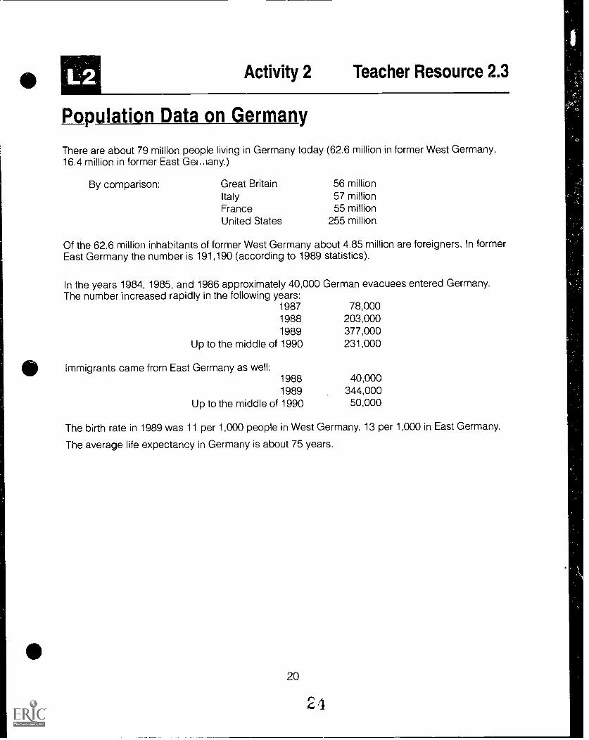
Population Data on Germany
There are about 79 million people living in Germany today (62.6 million in former West Germany,16.4 million in former East Get any.)
By comparison: Great Britain 56 millionItaly 57 millionFrance 55 millionUnited States 255 million
Of the 62.6 million inhabitants of former West Germany about 4.85 million are foreigners. In formerEast Germany the number is 191,190 (according to 1989 statistics).
In the years 1984, 1985, and 1986 approximately 40,000 German evacuees entered Germany.The number increased rapidly in the following years:
1987 78,0001988 203,0001989 377,000
Up to the middle of 1990 231,000
Immigrants came from East Germany as well:1988 40,0001989 344,000
Up to the middle of 1990 50,000
The birth rate in 1989 was 11 per 1,000 people in West Germany, 13 per 1,000 in East Germany.
The average life expectancy in Germany is about 75 years.
20
24

L2 Activity 3 Transparency 5
Population Density
Populationdstapproximately79 Million
Area:357,046 km2
Federal Republicof Germany
United Statesof America
AlabamaGeorgiaSouth Carolina
Populationapproximately255 Million
Area:9,372,619 km2
Populationapproximately14.1 Million
Total Area:367,073 km2
222
27
38
Inhabitantsper km2
Inhabitantsper km2
Inhabitantsper km2
21BEST COPY AVAILABLE

Mt_ Activity 4 Worksheet 2.2
Outline Map of Germany
C.
pp..000.CP
C=.it
o.
Bremen
North Rhine-Westphalia
Rhineland-Palatinate
Saarland
Schleswig-Holstein
Hambu
Lower Saxony
Hesse
Baden-Wuerttemberg
Saxony -Anhalt
Thuringia
Bavaria
Mecklenburg-Western Pomerani
Brandenburg
Saxony
22
2

Activity 4 Handout 2.2
Population Density in the German States
The population density varies from state to state in Germany:
State Inhabitants per km2
Hamburg 2,154Bremen 1,668North Rhine-Westphalia 502Saarland 414Baden-Wuerttemberg 239Hesse 268Rhineland-Palatinate 186Schleswig-Holstein 165Bavaria 159Lower Saxony 153Thuringia 165Saxony 267Saxony-Anhalt 145
Brandenburg 91
Mecklenburg-Western Pomerania 82Berlin 3,862
Germany is one of the most densely populatedcountries in Europe. The greatest density of popu-lation is in the Ruhr region. Here about 5,000people live per square kilometer. On the average,222 people live on one square kilometer. In 1989the population density in East German was152/km2 and in West Germany 252/km.
23
KEY
Population Density/km2 Map Color
< 100
100-199
200-299
300-399
400-499
500-599
> 600
red
green _yellow
white
blue
brown
orange

L3
Lesson 3 The Interaction of the GermanPeople with Their Environment
Lesson Objectives
Materials and Resources
The student will be able to:
analyze the various types of industry in Germany and compare themwith those in the United States.interpret map and statistical data to examine the environmental impactof industrialization in Germanyformulate possible solutions to the problem of acid rain as it impactsboth Germany and the United States.
Activity 1 Land Use in Germany
Transparency 6Worksheet 3.1Teacher Resource 3.1Transparency 7
Activity 2 Industrial Areas in Germany
Worksheet 3.2Teacher Resource 3.2Transparency 4Handout 3.1
Atlases
Activity 3 Pollution in Germany
Activity 4 The Environment
Handout 3.2Handout 3.3Worksheet 3.3Transparency 3
Transparency 4Handout 3.1
Handout 3.4Worksheet 3.4
25
"Land Use""Land Use Statistics""Land Use in Germany""International Commerce"
"Industrial Areas""International Trade""Types of Industries""Important Industrial Areasarid Mineral Resource Locations"
"Acid Rain in Germany""Product Map of Germany""Acid Rain Effects""Important Industrial Areasand Location of Mineral Resources""Types of Industries""Important Industrial Areas andMineral Resource Locations"
"Environment v. Employment Scenario""Decision Making Chart"

L3
ACTIVITIES
Activity 1 Land Use in (lermanyGermany has the largest population of any
country in Western Europe. Given its high popula-tion density, an important factor to consider is howthe limited natural resources are allocated for use.Have students analyze Transparency 6 and com-plete Worksheet 3.1 "Land Use Statistics." Basedon the data provided in the circle graph in Trans-parency 6 and Teacher Resource 3.1 "Land Use inGermany" have students complete the worksheetchart. Information will need to be computed usingpercentages from the graph. Then, have studentsconsult Transparency 7 and discuss Germany'smajor trading partners and the types of productsthat Germany distributes worldwide. Teacher Re-source 3.2 "International Trade" can be used tohelp students construct a data retrieval chart ofthe major trading partners, major imports andmajor exports of Germany.
Activity 2 Industrial Areas in GermanyThe type of industries that have been developed
in former East and West Germany provide impor-tant economic comparisons with other nations. Toexplore this topic, assign students to groups oftwo or three members and ask each group toidentify the location and type of German industryunder the first two columns of Worksheet 3.2 "In-dustrial Areas." Background and graphic informa-tion associated with Transparency 4 and Handout3.1 "Important Industrial Areas and Mineral Re-source Locations" should be consulted to com-plete this task. Then, using U.S. atlases or othermedia resources, ask the groups to record thenames of equivalent industrial sites found in theUnited States in the third column of the chart.
26
Activity 3 Pollution in GermanyThe growing strain on the environment is one of
the central problems to which government and pri-vate citizens alike must devote more and more en-ergy and money. Tell students they are scientistsstudying the effects of industrialization on the envi-ronment. Ask students to complete Worksheet 3.3"Acid Rain Effects" by consulting the diagram andbackground notes on Handout 3.2 "Acid Rain inGermany" Have each student team up with two orthree others to speculate about the problemsposed by this type of pollution for people living inthe United States. Once the worksheet has beencompleted and the class has discussed theanswers, tell them that they have an opportunity ofvisiting three sites in Germany where they believeacid rain might be most severe. Based on Hand-out 3.1 "Important Industrial Areas and Mineral Re-source Locations," Transparencies 3 and 4 andHandout 3.3 "Product Map of Germany" studentsmay identify the three regions most likely to havethis type of environmental pollution. Have themwrite a short paragraph that explains why theychose a particular geographic area to study, usingevidence from the consulted materials to supporttheir decision. Student answers will vary but mayinclude the following:
northern Germany near Hamburg because of ex-tensive livestock and grain production and oildrilling.the south-central region near Frankfurt becauseof major industrial areas, grain production andvineyards.eastern Germany near Leipzig because ofheavy mining and industrial centers and tfagricultural production of wheat and pota.tces.
Activity 4 The EnvironmentDecisions about environmental problems affect
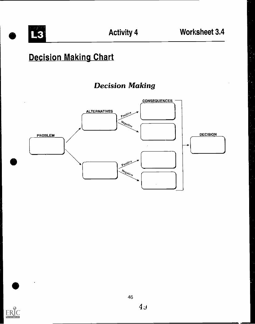
other areas of daily life and can involve difficultchoices. Distribute copies of Handout 3.4 "Environ-ment vs. Employment Scenario" and Worksheet3.4 "Decision Making Chart." After students haveread the scenario, divide the class into fourgroups: members of the state parliament (Saxony-Anhalt), factory workers, business merchants, andcitizens of the community. Have each group usethe decision making chart to organize several op-tions and the possible effects and consequencesof following these options from the perspective oftheir group.
Students in each group should prepare a one-page position statement in which they explaintheir decisions using the Decision Making Chart.Allow representatives from each group to read theposition statement of each of the other groups.Conduct a mock hearing before the environmentalcommittee of the parliament in which the factoryworkers, merchants and citizens express theiropinions and concerns. Compare the solutions ofeach group as they are presented and discusswith the class why each group might have arrivedat their particular solution. Each group shoulddefend its decision based on the informationrecorded on their Decision Making Charts.Themembers of parliament will then discuss thevarious proposals and decide on a course ofaction.
27

L3 Activity 1 Transparency 6
Land Use
0!=
ExcavatedMaterialConstructionWaste
HouseholdGarbage
Million MetricTons per Year ^ Industrial
Waste23 Sludge2.7 Misc.
Incinerator
28
Composting
BEST COPY AVAILABLE
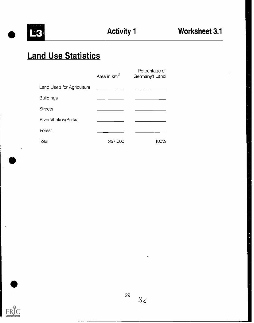
Activity 1 Worksheet 3.1
Land Use Statistics
Area in km2Percentage of
Germany's Land
Land Used for Agriculture
Buildings
Streets
Rivers/Lakes/Parks
Forest
Total 357,000 100%

L3 Activity 1 Teacher Resource 3.1
Land Use in Germany
Eighty-one percent of the land surface of Ger-'many consists of fields, forests, and pastures(79% in former West Germany, 87% in former EastGermany). The new federal states in the east aremore heavily agricultural than the old, with morethan 35% of the land area being used as farmland(in old West Germany only 30% was used for farm-ing). In the states of Saxony-Anhalt and Mecklen-burg-Western Pomerania as much as 50% of theland is devoted to agriculture.
Thirty percent of Germany (74,700 km2 in theWest, 29,800 in the East) is covered with forests.Most of the forest land is found in the uplands andmountains. In the north the forests are predomi-nately oak and birch, in the middle oak, birch, andmixed forests, and in the south forests with spruceand fir, as well as mixed woodlands. The states ofRhineland-Palatinate and Hesse have the greatestpercentage of their surface in forests, with 40.7%and 40.2% respectively.
Of the 357 000 km2 land area of Germany181,000 km2 is devoted to agriculture and forestry(119,000 km2 west, 62,000 east), which is about50.4% of the total.
In 1989 there were in West Germany 648,800farms (representing a reduction of 2.5% from theprevious year). The average size of a Germanfarm is 17.7 hectares (= 0.177 km2). In formerEast Germany there were about 4,519 farms. Theaverage size of a farm was about 1,285 hectares.Around 95% of these were organized into collec-tive farms, which could be as large as 5,000 hec-tares.
co30
In 1989 about 3.8% of West German workerswere employed in agriculture; in East Germany thecorresponding figure was 11%.
By comparison: FranceItalyGreeceSpain
(according to 1988 statistics)
70/0
10%27%15%
A large number of agricultural workers in formerWest Germany were only employed in a,,icultureas a side-line.
In former West Germany more sugar, wine, milkproducts, beef, veal, pork, and wheat were pro-duced than were consumed by the public.
Overproduction is a central agricultural problemin former East Germany. According to the stand-ards in present-day Germany there are too manyfarmers producing too many products to keepfarm prices high.
In the middle of 1990 the agricultural problemsof former East Germany became the concern ofthe European Economic Community.

L3 Activity 1 Transparency 7
International Commerce
Chief Exports: Chief imports:
Raw Materials
Chemical Products
Iron/Steel
Metal GoodsFoodstuffs
Most Important Trading Partners:
Italy
Great Britain
Switzerland
31
BEST COPY AVAILABLE
34

L3 Activity 2 Worksheet 3.2
Industrial Areas
German Industrial Areas
Example:Stuttgart
Products Manufactured Similar Industrial Areasin the United States
motor vehicles Detroit
32
35
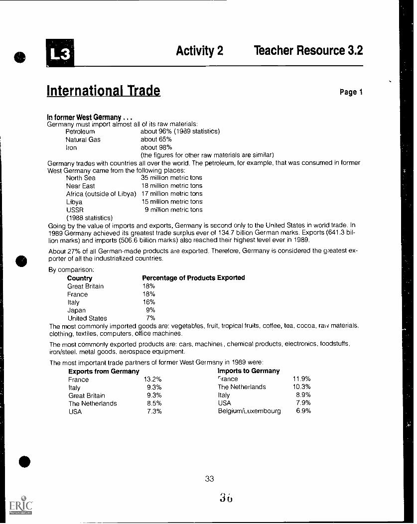
Activity 2 Teacher Resource 3.2
International Trade Page 1
In former West Germany ...Germany must import almost all of its raw materials:
Petroleum about 96% (1989 statistics)Natural Gas about 65%Iron about 98%
(the figures for other raw materials are similar)Germany trades with countries all over the world. The petroleum, for example, that was consumed in formerWest Germany came from the following places:
North Sea 35 million metric tonsNear East 18 million metric tonsAfrica (outside of Libya) 17 million metric tonsLibya 15 million metric tonsUSSR 9 million metric tons(1988 statistics)
Going by the value of imports and exports, Germany is second only to the United States in world trade. In1989 Germany achieved its greatest trade surplus ever of 134.7 billion German marks. Exports (641.3 bil-lion marks) and imports (506.6 billion marks) also reached their highest level ever in 1989.
About 27% of all German-made products are exported. Therefore, Germany is considered the greatest ex-porter of all the industrialized countries.
By comparison:Country Percentage of Products ExportedGreat Britain 18%France 18%Italy 16%Japan 9%United States 7%
The most commonly imported goods are: vegetables, fruit, tropical fruits, coffee, tea, cocoa, rav materials,clothing, textiles, computers, office machines.
The most commonly exported products are: cars, machines, chemical products, electronics, foodstuffs,iron/steel. metal goods, aerospace equipment.
The most important trade partners of former West Germany in 1989 were:Exports from Germany Imports to GermanyFrance 13.2% rrance 11.9%
Italy 9.3% The Netherlands 10.3%
Great Britain 9.3% Italy 8.9%The Netherlands 8.5% USA 7.9%
USA 7.3% Belgium/Luxembourg 6.9%
Activity 2 Teacher Resource 3.2
International Trade Page 2
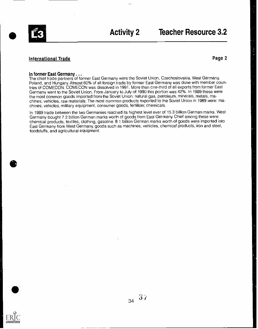
In former East Germany ...The chief trade partners of former East Germany were the Soviet Union, Czechoslovakia, West Germany,Poland, and Hungary. Almost 60% of all foreign trade by former East Germany was done with member coun-tries of COMECON. COMECON was dissolved in 1991. More than cne-third of all exports from former EastGermany went to the Soviet Union. From January to July of 1990 this portion was 42%. In 1989 these werethe most common goods imported from the Soviet Union: natural gas, petroleum, minerals, metals, ma-chines, vehicles, raw materials. The most common products exported to the Soviet Union in 1989 were: ma-chines, vehicles, military equipment, consumer goods, fertilizer, chemicals.
In 1989 trade between the two Germanies reached its highest level ever of 15.3 billion German marks. WestGermany bought 7.2 billion German marks worth of goods from East Germany. Chief among these were:chemical products, textiles. clothing, gasoline. 8.1 billion German marks worth of goods were imported intoEast Germany from West Germany, goods such as machines, vehicles, chemical products, iron and steel,foodstuffs, and agricultural equipment.
343/

L3 Activity 2 Transparency 4
Types of Industries
The Ruhr Region
Emden
-sib. Shipbuilding
Iron and Steel
6. Industry
9 Electrical Industry
40 Chemical Industry
41St Mining
op Truck Manufacturing
AutomobileManufacturing
35 BEST COPY AVAILABLE

111 Activity 2 Handout 3.1
Important Industrial Areasand Mineral Resource Locations
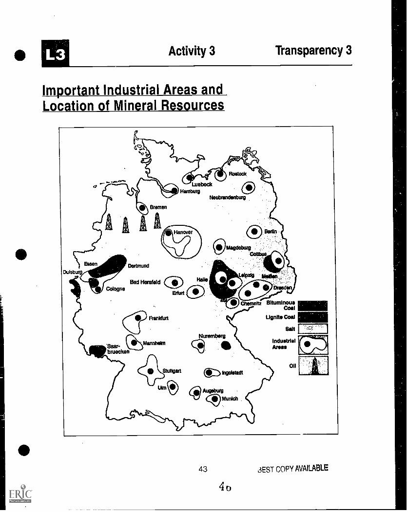
Industrial AreasGermany is an industrialized country. The impor-tant industrial areas are:
the Ruhr region, including the areas aroundDuesseldorf and Colognethe area around Frankfurtthe Mannheim/Ludwigshafen areaStuttgart and the Neckar Valleythe Hanover/Braunschweig regionthe Dresden/Chemnitz regionthe region around Leipzigthe Halle regionthe territory around Cottbus
In addition there are the following cities and theirsurrounding areas:
Former West GermanyMunichAugsburgUlmIngolstadtSaarbrueckenBremenNurembergHamburgLuebeck
Former East GermanyZwickauErfurtMei Ben -MagdeburgNeubrandenburgRostock
In former East Germany most of the industrializa-tion is concentrated in the south. The Halle-Bitter-feid-Merseburg triangle is particularly industriallydeveloped. Almost 40% of all chemical productsare made here.
The most heavily industrialized areas are alsothe most densely populated areas.
Several industries, such as coal, steel, and ship-building, are becoming less important than moremodern industries, such as mechanical engineer-ing [machine making] and electronics. For this rea-son traditional industrial regions, such as the Ruhrregion and cities with shipyards, are having to re-structure. This is especially true of all of the indus-trial centers in former East Germany!The quality of the infrastructure varies greatly
among the industrial regions. While in the areathat was formerly West Germany the infrastructureis very sound, the quality of the infrastructure in
36
Page 1
the new states of former East Germany is ratheralarming. This goes for the streets as well as thecommunication system.
The industrial structure in the new states is incritical condition. In order to improve the situationit is necessary to make many changes; in particu-lar, most of the outdated equipment needs to be re-placed. The outmoded plants that burn browncoal need to be replaced by more environmentallyfriendly installations. In the long term it is plannedto replace brown coal with other sources of energysuch as bituminous coal, natural gas, and petro-leum.
3

Activity 2 Handout 3.1
Important Industrial Areas and Mineral Resource Locations Page 2
Mineral ResourcesGermany is poor in mineral resources. There aresignificant deposits only of rock salt, potassiumsalt, brown coal and bituminous coal.
Coal: The largest deposits of brown coal are inthe area around Cottbus. Another significant de-posit is found in the area between Aachen and Co-logne. In 1989 East Germany produced 301million metric tons of brown coal. In West Ger-many 110 million metric tons were produced.
The greatest. deposits of bituminous coal are lo-cated in the Ruhr region. Further bituminous coal-producing regions are the Saar region and thearea around Aachen. In 1989 the total productionwas 72 million metric tons, of which 50.5 metrictons came from the Ruhr region.
By comparison:France 13 million metric tonsGreat Britain 101 million metric tonsU.S. 813 million metric tons(in 1988)
The amount of coal produced is not enough tocover the energy needs.
Petroleum: Petroleum is produced in the regionbetween the Weser and Ems rivers as well asnorth of Hanover and south of Leipzig. In WestGermany in 1989 the production of petroleumsank 4.3% to 3.7 million metric tons. In compari-son, 110 million metric tons were consumed. In for-mer East Germany 4.9 million metric tons ofpetroleum products were produced in 198P.
Natural gas: Natural gas is produced in the samepaces as petroleum. About 15 million cubicmeters are produced in Germany annually.
Salt The territory of former West Germany is oneof the most salt-rich regions in the world. Germanyproduces about 6 million metric tons of salt and 8million metric tons of potassium salt a year. This is10% of the world production The largest salt de-posits are in the area around Hanover-Hildesheimand near Bad Hersfeld.
Iron: The iron i. dustry is in decline. In West Ger-many in 1989, 33 million metric tons of iron were
37
processed, of which only about 1% came fromGerman mines. The most prominent iron-produc-ing region is the area around Salzgitter.
U
Activity 2 H "idout 3.1
Important Industrial Areas and Mineral Resource Locations
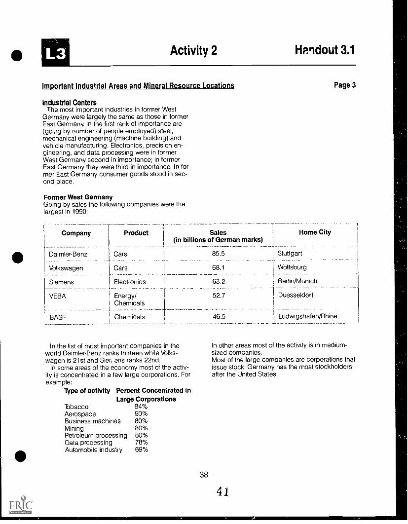
Industrial CentersThe most important industries in former West
Germany were largely the same as those in formerEast Germany. In the first rank of importance are(going by number of people employed) steel,mechanical engineering (machine building) andvehicle manufacturing. Electronics, precision en-gineering, and data processing were in formerWest Germany second in importance; in formerEast Germany they were third in importance. In for-mer East Germany consumer goods stood in sec-ond place.
Former West GermanyGoing by sales the following companies were thelargest in 1990:
Page 3
Company
Daimler-Benz. _ .
Product
Cars
Sales(in billions of German marks) ;
;--
85.5 Stuttgart
Volkswagen Cars 68.1 Wolfsburg
Siemens Electronics 63.2 Berlin/Munich
VEBA Energy/ 52.7 DuesseldorfChemicals+
BASF ' Chemicals 46.5 Ludwigshafen/Rhine1
In the list of most important companies in theworld Daimler-Benz ranks thirteen while Volks-wagen is 21st and Sier, ens ranks 22nd.
In some areas of the economy most of the activ-ity is concentrated in a few large corporations. Forexample:
Type of activity Percent Concentrated inLarge Corporations
Tobacco 94%Aerospace 90%Business machines 80%Mining 80%Petroleum processing 80%Data processing 78%Automobile industry 69%
In other areas most of the activity is in medium-sized companies.Most of the large companies are corporations thatissue stock. Germany has the most stockholdersafter the United States.
38
41

Activity 2 Handout 3.1
Important Industrial Areas and Mineral Resource Locations
Former East GermanyThe economy in former East Germany is in the
process of being changed from a communist-con-trolled demand economy to an open market eco-nomy.
In the mid 1970s East Germany began the pro-cess of combining companies that manufacturedsimilar products into large combines, of whichthere were 220 altogether.
At the end of the 80s about 95% of East Germancompanies were government owned, the so-called "Volkseigene Betriebe" (People's Busi-nesses") or VEB. There were only a relatively fewprivate businesses, and these businesses wereonly on a rather small scale.
The following were among the largest industrialcombines in East Germany in 1988:
Combine
VEB Kombinat Robotron
VEB Kombinat Fortschritt
VEB Kombinat Baumwolle
VEB Mansfeld-Kombinat"Wilhelm Pieck"
Type ofProduct
Data Processing andoffice machinery
Farming Equipment
Textiles
I
1 Metal Industry
Sales(in billions of East
German marks
A major task since the joining of the East andWest German economies is to privatize East Ger-many's industry and bring it up to speed with theworld-wide open market economy. This task hasbeen put in the hands of the "Treuhandanstalt"("Faithful-hand-institution"), which had taken in 1.5billion marks as of November 1990. As of January1991, 450 companies had come into privatehands.
In September 1990 26% of the business peoplein former West Germany had cooperated withtheir East German colleagues. Twelve percentmore had concrete plans to do so.
Legal uncertainties about property, surplus per-sonnel in companies, and antiquated equipment
39
11.4
Page 4
Home City
Dresden
8.7 Neustadt (Saxony)
8.6 Karl-Marx-Stadt(today Chemnitz)
7.7 Eisleben
are the most difficult problems facing the peoplewho are trying to unite industries in former EastGermany with that of the West.
The process so far has shown that many EastGerman companies cannot be made competitivein the Western economy.

Acid Rain in Germany
Acid rain How it is formed and how it damages the environment
..,:;-6:,. ,:::12 ... and combines with
,,,i
'',4ta. r,,oxygen and rainwater..,.,,,
ok ti tIlt
SP The acid %, ,1 attacks buildings tx is. X X X
a s a as ILxirt it ii. ' % x
0 Sulfur dioxideL is emitted ...
Combustion of coaland oil convertsthe sulfur contentinto sulfur dioxide
is11
1.tt 11
1111 11 11 I
1and pene-
trates the soil
0 FloraI species die
0,#)..4k7'3ffltijj 4( 4;WW:bytteriNtittAi
1411,1
kc,astt,4711 tr44t2'.4;;Ilkk-41j, .4,Zitg.Ip1/1, `-ty-ifoo#.,"figt:Oi
.,r.. 04. 4 es:4f4q c41%
_rmi ,,114*,-ita--
(1) Acidification destroys
. -,
"1-t-tv,,u,
141.44:11-71v.1-\117.[Iitta
t.haels leg.tv,..4,.,11q-2,
11°Jki eg,i4111A:74.4V4(4..0..01FIllitgf--ftlAV
II ,-;;;V,;11,::jjk-7ii4A,:e-fASS."?,13IrefAittANI,"
andcl's biological
In former West Germany 2.9 million metric tons ofnitrous oxide were released into the atmospherefrom traffic, industry, and private homes. Throughefforts at pollution reduction this number shouldbe down to 2 million metric tons by 1995.
The condition of the environment in former EastGermany is one of the most pressing problemsthe new Germany has to face. Air pollutionreached a dramatic extreme; the burning of browncoal (lignite or soft coal) released particularly
40
large amounts of pollutants. This resulted in anemission of 359 kg of sulphur dioxide and nitrousoxide per person per year. Particularly hard-hit arethe areas around Halle, Bitterfeld, Leipzig andCottbus.
The term "Waldsterben" (dying forests) has beencoined to refer to the widespread unhealthy condi-tion of the forests. In 1989, 3.9 million hectares(52.9% of the woodlands) had been affected.

L3 Activity 3 Handout 3.3
Product Map of Germany
Ifs
DairyProduc
PR,Hogs
lY am...Hogsttle
HamburgOil
$productsForest Be
,=, ....... Sugar
WIProducts
$Dairy Grain
$iii Bremen Wheat
WheatGrain
Gas Oil Grain
O.;
,_. ....A '', 0 IIBerlin
OilMining roIronOil tli 1I Wheat liltMining
7 77 c"; ,.... C) Wheat'1::43 products
Forest
1-1 1=1 ..L'i PotatoeZinc c'..7Coal Coal 1=4 ./.1:* .7"7
'd'7 DortmundMining Sugar I-1
CoalBeets ...../Mining1-1
.7i'1,..., 1-1V1 Leipzig
ugarGra ':n7 7:
Copper CopperMining
ets t .!. Forest Grain
ologne Mining Ironproducts
S17;Bonn Grain
productsIron
Coal '4,5 roni Cn--.Potatoes
1=1 ,so
Graint Frankfurt
1-1Coal
4111p1=1Coal Forest
products
1=1Coal
iiGrapes
o 1/43IPotatoes
Grapes
GrainWheat
Grapes
Forestproduts
\.\\.1=-1
Mining
airyForest
product
Potatoes
Grain
Stuttgartfan
Grain
Iron
Grain
Munich
Wheat
tArDairy Dairy
Products Products
41
4.1
Wheat
.0Forest
products
Grain
1-1Coal
1-1Coal
Potatoes
Dresden
BEST COPY AVAILABLE

Activity 3 Worksheet 3.3
Acid Rain Effects
1. In the process which produces acid rain, what is the first step?
2. Where is sulfur dioxide emitted? What other types of emissions pose similar hazards?
3. How is sulfur dioxide in the atmosphere brought back to the ground?
4. What are the three problems caused by acid rain (both in Germany and in the UnitedStates)?
5. Explain the relevance of the acid rain problems in Germany for people living in theUnited States.
Activity 3 Transparency 3
Important Industrial Areas andLocation of Mineral Resources
01.gib
=.
Duisburg
chertinitz BituminousCoal
Lignite Coal
Salt
IndustrialAnus
Oil
43 3EST COPY AVAILABLE

Activity 3 Transparency 4
Types of Industries
...11b. Shipbuilding
Iron and Steel
Q Industry
QElectrical Industry
40 Chemical Industry
BEST COPY AVAILABLE
44
4i
Activity 4 Handout 3.4
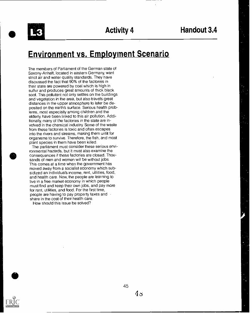
Environment vs. Employment Scenario
The members of Parliament of the German state ofSaxony-Anhalt, located in eastern Germany, wantstrict air and water quality standards. They havediscussed the fact that 90% of the factories intheir state are powered by coal which is high insulfur and produces great amounts of thick blacksoot. This pollutant not only settles on the buildingsand vegetation in the area, but also travels greatdistances in the upper atmosphere to later be de-posited on the earth's surface. Serious health prob-lems, most especially among children and theelderly, have been linked to this air pollution. Addi-tionally, many of the factories in the state are in-volved in the chemical industry. Some of the wastefrom these factories is toxic and often escapesinto the rivers and streams, making them unfit fororganisms to survive. Therefore, the fish, and mostplant species in them have been killed.
The parliament must consider these serious envi-ronmental hazards, but it must also examine theconsequences if these factories are closed. Thou-sands of men and women will be without jobs.This comes at a time when the government hasmoved away from a socialist economy which sub-sidized an individual's income, rent, utilities, food,and health care. Now, the people are learning tolive in a free market economy in which peoplemust find and keep their own jobs, and pay morefor rent, utilities, and food. For the first time,people are having to pay property taxes andshare in the cost of their health care.
How should this issue be solved?
Activity 4 Worksheet 3.4
Decision Making Chart
PROBLEM
Decision Making
ALTERNATIVES
1
1
CONSEQUENCESc
I.... ), j DECISION
Lesson 4 Movement and Diversity inGermany
Lesson Objectives The student will be able to:
discuss the importance of and challenges presented by changes in im-migration to Germany and the United States.
analyze Germany's position on immigration and the types of groups
wishing to establish citizenship there.
Materials and Resources
Activity 1 Foreigners in Germany
Worksheet 4.1
Worksheet 4.2
"Map of the Continental United States"
"Map of Europe"
Compass for drawing circles to scale
Transparency 8 "Foreigners in Germany"
Handout 4.1 "Foreigners in Germany'
Activity 2 Immigration to Germany
Handout 4.2 "Basic Law"
47 '00

ACTIVITIES
Activity 1 Foreigners in GermanyDistribute copies of Worksheets 4.1 "Map of the
Continental United States" and 4.2 "Map of Eu-rope" and a compass to groups of students. Directthe groups to extend the radius of the compass toequal 500 miles as indicated by the scale on eachmap. Placing the point of the compass on St.Louis (S) and Frankfurt, Germany (F), ask groupsto draw circles on both maps. Repeat the sameprocedure using 1,000 miles as the radius insteadof 500 miles. Ask student groups to compare ob-servations about the cultural diversity found withineach pair of circles, particularly what challengesare posed by traveling 500 miles east of Frankfurtas opposed to traveling 500 miles east of St. Louis.
Students should discover that there is far morecultural diversity within a 500 mile radius fromFrankfurt than there is within a 500 mile radiusfrom St. Louis. Because of the proximity of diversecultures around Germany, contrasted with the eth-nic homogeneity within European nation-states, im-migration and refugee asylum are different forGermany than for the United States. Have studentsanalyze Transparency 8 and Handout 4.1 "Foreign-ers in Germany" to verify how many differentcultural groups are immigrating to Germany.
Activity 2 Immigration to GermanyWhile there have been attacks on foreigners in
many European countries, in Germany these at-tacks often raise the specter of the Nazi past. Onthe other hand, postwar Germans have given ref-uge to numerous political activists who fledregimes of oppression.They encourage the inte-gration of foreign-born workers and their familiesinto Germany's society, and as champions inforeign travel, are not known to be xenophobic.Distribute copies of Handout 4.2 "Focus on For-eigners in Germany" for students to read aboutcontemporary attitudes and events on immigrationto Germany. Then, have students analyze Hand-out 4.3 "Basic Law" and within groups composerecommendations to Helmut Kohl as to whetherthe existing Basic Law relating to immigrantcitizens should be upheld or revised in some otherway.
One way to focus students research and analy-sis is to pose the question about what kinds of re-
strictions, if any, should be placed on immigrantgroups and refugees entering Germany. Whattype of pressures and concerns exist in Germanythat affect such a decision which may or may notexist in the United States? For example, factors toconsider include:
How would you, as a renter during housingshortage, feel about foreign newcomers?What attitude differences remain betweenformer East and West Germans?Since local authorities in Germany must pro-vide asylum seekers with housing, medicalservices and an allowance, how do more es-tablished citizens feel about the recent in-flux of refugees?
These recommendations can take the form ofwritten reports or oral presentations from thevarious student groups.
48 51
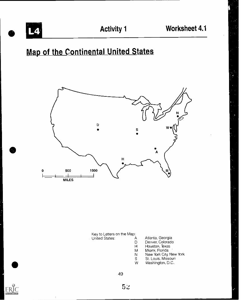
L4 Activity 1 Worksheet 4.1
Map of the Continental United States
0
MILES
Key to Letters on the Map:United States: A Atlanta, Georgia
D Denver, ColoradoH Houston, TexasM Miami, FloridaN New York City, New YorkS St. Louis, MissouriW Washington, D.C.
49
r 9

Activity 1 Worksheet 4.2
Map of Europe
0 1500 11000 12000 km
10 1500 11000 miles
Key to Letters on the Map:Europe: A Ankara, Turkey
B Berlin, GermanyL London, Great BritainM Madrid, SpainP Paris, FranceP Prague, Czech RepublicR Rome, ItalyW Warsaw, Poland
50
BEST COPY AVAILABLE
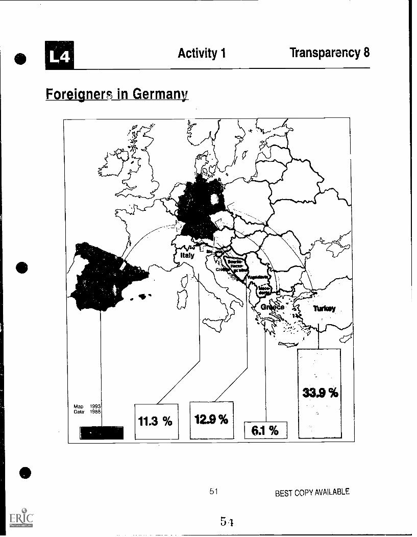
Activity 1 Transparency 8
Foreigners in Germany
51 BEST COPY AVAILABLE
5

Activity 1 Handout 4.1
Foreigners in Germany
In 1991, approximately 5 million foreigners lived inGermany (6.5% of the total population). Many for-eigners live with their families in Germany.
The foreigners come mainly from the followingcountries:
Country Number of People Percent ofForeignPopulation
TurkeyFormer YugoslaviaItalyGreeceAustriaSpainIranMoroccoLebanon(according to 1989many)
In 1989 in East Germany there were 191,190 for-eigners, of which:
106,095 were employed10,225 were students28,898 were apprentices45,972 miscellaneous
Foreigners have been particularly attracted to in-dustrialized areas. For the states in the westernsector the numbers may be broken down as fol-lows:
1,612,600 33.3%610,500 12.6%519,500 10.7%293,600 6.1%171,100 3.5%127,000 2.6%81,300 1.7%61,800 1.3%30,100 0.6%
statistics from West Ger-
Baden-Wuerttemberg 968,594Bavaria 796,651Berlin (West) 276,396Bremen 56,839Hamburg 166,172Hesse 552,411Lower Saxony 310,770North Rhine-Westphalia 1,453,716Rhineland-Palatinate 182,768Saarland 50,768Schleswig-Holstein 90,797
(There are no exact statistics available for formerEast Germany.)
52
In West Germany in 1990 there were 1.8 million for-eigners employed as "guest workers" [i.e., non-citizens with the equivalent of a "green card"], ofwhich 1.2 million wsre male. Most of the "guestworkers" are employed in manual labor. Most ofthe foreign workers come from the following coun-tries:
Turkey 594,586Former Yugoslavia 312,974Italy 175,148Greece 105,448
In 1989, 232,512 of the foreigners were unem-ployed. This is 13% of the foreigners comparedwith 7.9% of the total population.
Guest workers enjoy the same governmentalbenefits as do citizens, that is health insurance,job security, retirement benefits, aid to familiesand unemployment benefits. They often live inethnic communities and maintain their owncultural identity.
People who are being persecuted in their nativecountries for political, racial, or religious reasonsmay seek asylum in Germany. In 1990 the numberof people seeking asylum climbed to 193,063,which was 59% higher than in 1989. In 1991 thenumber of people seeking asylum climbed to256,112. Just under half of the refugees camefrom Eastern European countries. The countries oforigin for refugees in 1989:
Poland 26,092Turkey 20,020Former Yugoslavia 19,423Sri Lanka 7,758Lebanon 6,240Iran 5,768
Because of the flood of refugees coming intoGermany, new regulations are being passed tocontrol them. The new federal states are being re-quired to take in 20% of the refugees.

Activity 2 Handout 4.2
Basic Law
The Basic Law of the Federal Republic of Germany (May 23, 1949) is the constitution forGermany. The following Articles relate to immigration and German citizenship:
"Article 3(Equality before the !aw)
(1)All persons shall be equal before the law.(2)Men and women shall have equal rights.(3)No one may be prejudiced or favored because
of his sex, his parentage, his race, his lan-guage, his homeland and origin, his faith, or hisreligious or political opinions."
(Note: Recruited by the German government,the foreign (guest) workers who did not returnhome can apply for naturalized citizenship after10 years. Many who have stayed have notbeen naturalized. Children of these foreignersborn in Germany are not automatically grantedGerman citizenship.)
"Article 16(Deprivation of citizenship, Extradition, Right of asylum)
(1)No one may be deprived of his German citizen-ship. Loss of citizenship may arise only pur-suant to law, and against the will of the personaffected only if such person does not therebybecome stateless.
(2)No German may be extradited to a foreigncountry. Persons persecuted on politicalgrounds shall enjoy the right of asylum."
"Article 116(Definition of 'German', Regranting of citizenship)
(1)Unless otherwise provided by law, a Germanwithin the meaning of this Basic Law is a per-son who possesses German citizenship or whohas been admitted to the territory of the Ger-man Reich within the frontiers of 31 December1937 as a refugee or expellee of German stock(Volkszugehoerigkeit) or as the spouse or de-scendant of such person.
(2)Former German citizens who, between 30January 1933 and May 1945, were deprived oftheir citizenship on political, racial, or religiousgrounds, and their descendants, shall be re-granted German citizenship on application.They shall be considered if they have estab-
53
lished their domicile (Wohnsitz) in Germanyafter 8 May 1945 and have not expressed con-trary intention.
(Note: People from Eastern Europe who canclaim German ancestry, and who can get toGermany, will be granted all rights of citizen-ship. Many of them cannot speak the Germanlanguage.)
"Article 119(Refugees and expellees)In matters relating to refugees and expellees, inparticular as regards their distribution amongthe Laender, the Federal Government may, withthe consent of the Bundesrat, issue regulationshaving the force of law pending the settlementof the matter by federal legislation. The FederalGovernment may in this matter be authorized toissue individual instructions for particularcases. Except where there is danger in delay,such instructions shall be addressed to thehighest Land authorities."
(Note: Land and Laender refer to the stateswithin the country. The Bundesrat is the FederalCouncil or the assembly of the federal state rep-resentatives.)

L5
Lesson 5 German Unification andRegional Changes
Lesson Objectives The student will be able to:
describe the historical and contemporary significance of unification asan issue for Germans and people of other nations.identify various linguistic and historical influences on German culture invarious regions.
Materials and ResouresActivity 1 Regions in Germany
Transparency 2Transparency 3
Transparency 4III Transparency 10
Transparency 11Transparency 9Transparency 12Teacher Resource 5.1
Activity 2 German Unification
"Landforms, Rivers, and Canals""Important Industrial Areas and Location of MineralResources""Types of Industries""The German Language""Radio and Television""German Unity"The Federal States of Germany""The German Language"
Teacher Resource 5.2 "German Unific dtion Timeline"Transparency 9 "German Unity"Teacher Resource 5.3 The Federal States"Handout 5.1 "Three Photographs"Worksheet 5.1 "Analysis of Three Photographs"
Activity 3 Opening the Berlin Wall
Handout 5.2 "Reflections on the Opening of the Border
Activity 4 East German Perspectives on Unificaiton, Part A
Handout 5.3 "Reflections of East German Teachers on Unification,July 1991"
Activity 5 East German Perspectives on Unification, Part B
Handout 5.4 "A Letter From Anne. . . ."
Activity 6 World Press Views on Unification
Handout 5.5 "Differing Views on Unification"
55

LS
ACTIVITIES
Activity 1 Regions in GermanyThe basic unit of geographic analysis is the "re-
gion," an area that is unified and distinguished byspecific criteria. The most common type of re-gions are those displaying political power (e.g.,nations, provinces, countries, cities), but there arecountless other ways to define meaningful regionsdepending on the problem being considered.Some regions are defined by one characteristicsuch as a governmental unit, a language group,or a landform type, and others by the interactionof many complex features. While it represents anarea of political power, Germany also can beexamined in terms of the interplay of other factors.For example, from the end of World War II until1990, East and West Germany were developinginto distinct regions. This process is beingreversed today.
Divide students into groups of three and show allgroups the following transparencies in order:Transparency 2, Transparencies 3 and 4, andTransparencies 10 and 11. Ask each group to de-scribe the type of region(s) defined by each set oftransparencies.Then, have students discuss howthe interplay of characteristics defined above in-fluenced the creation of political regions as illus-trated by Transparencies 9 and 12.
The following is guide for what students shouldconclude about each Transparency:
Transparency 2--Physical features and environ-mental factorsTransparencies 3, 4--Natural resources and in-dustry locationTransparencies 10, 11--Linguistic and communi-cation patternsThe interplay of linguistic/communication pat-
terns (see Teacher Resource 5.1 for information re-garding, the historical development of regionallanguage differences in Germany), physical fea-tures, natural resources and location of industryserves to define political regions within Germanyas illustrated by Transparencies 9 and 12. Next,have student groups use atlas data to analyze fac-tors which define similar types of regions in theUnited States and prepare a set of maps of theUnited States showing information similar to thatprovided on Germany.
Activity 2 German UnificationUsing Teacher Resource 5.2 "German Unifica-
tion Timeline," discuss the major events leadingfrom the tearing down of the Berlin Wall to the unifi-cation of Germany. Show Transparency 9, whichindicates the outline of the two Germanies andBerlin prior to. October 3, 1990. The red lines divi-ding up former East Germany indicate the 14 ad-ministrative districts under Communist leadership.These 14 districts temporarily replaced the fiveGerman states which existed prior to World War IIand which were reinstated during unification. (SeeTeacher Resource 5.3 for additional informationabout the states.)
The teacher should introduce events that wereoccurring in the United States and elsewhere inthe world at approximately the same time. Forexample, Handout 5.1 (pages 1-3) shows a photo-graph of democratic demonstrations at TianamenSquare in China, the fall of the Berlin Wall, andYeltsin's opposition to thc. attempted coup in theSoviet Union. Assign students to groups of threeor four and provide each group with a set of thephotographs. Also, distribute one copy of Work-sheet 5.1 "Analysis of Three Photographs" andhave each group fill in thechart with the specificinformation requested in each column. Then, dis-cuss the relationship of the three events as relatedto the changing world order.
Activity 3 Opening the Berlin WallHandout 5.2 includes excerpts from reflections
written by a 13- year-old West German youth anda male teacher in his furties in December, 1989,shortly after the Berlin Wall, the symbol of divisionof East and West Germany, was both symbolicallyand physically torn asunder. Have students readthe excerpts or read desired sections to them. Askstudents:
How does each writer feel about the events hewitnessed?What positive things does each cite?What concerns does each raise?All things considered, does each have a favor-able view of what transpired and of the future?Are you surprised by any of their views? Why?

Activity 4 East German Perspectives on Unifi-cation, Part A
Handout 5.3 contains reflections and observa-tions recorded by American educators visitingLower Saxony, a state in what was formerly EastGermany. Distribute the handout to students,make a transparency, or read selected portions tostudents. Have them describe the feelings con-veyed, identify specific points raised by thevarious writers, and compare the observationswith those in Handout 5.2. Ask students:
What emotions and feelings are conveyed? Howdid the East Germans feel about unification?What indications do you find in these excerpts ofrestrictions placed on personal freedoms underthe old regime in the GDR?What changes in their daily lives are people inthe eastern section of Germany experiencing?Are these "good?" "bad?" On what basis do youmake your judgment?Have you ever had an experience similar to thatdescribed in excerpts #2 or #4? Explain.What do you think the headmaster meant by hisstatement (#8)?What is your reaction to excerpt #9? Comparethis statement with excerpt #7.How do these comments compare with those of-fered in the earlier handouts we read (Handouts4.2 and 4.3)?
Activity 5 East German Perspectives on Unifi-cation, Part B
Handout 5.4, "A Letter from Anne . .",
written in August 1991, provides one East Ger-man's perspective on the significance r' "TheWall," the regime under which she liven and theevents that led to the tearing down of the Wall andto unification. Distribute copies of the handout forstudents to read, or read selected portions of it tostudents. Ask students to consider the following:
Why didn't Anne leave East Germany? What doyou think of her decision?What clues can you find about Anne's feelingsabout the regime under which she lived andworked?How did the Wall affect her life?What was Anne's reaction to the fall of the Wall?What do you make of her reaction?How does Anne's reaction to the events of thefall of 1989 compare to those of Heinz and Hend-rick (Handout 5.2)?
57
Activity 6 World Press Views on UnificationHandout 5.5 contains selected views from The
World Press Review. The handout contains threequestions for students to consider as they readthe selections. Distribute the handout and havestudents read it and then discuss the questions.

L5 Activity 1 Transparency 2
Landforms, Rivers, and Canals
Oder-Spreenal
Foothillsof the Alps
58BEST COPY AVAILABLE
L5 Activity 1 Transparency 3
Important Industrial Areas and Location of MineralResources
Essen
Duisburg
4P)%r-
44 Bremen
A
Dortmund
Cologne
'Saar-bruecken
1.1
Bad Hersfeld
go.
LuebeckHamburg
0Frankfurt
Mannheim
Ulm
Erfurt
Halle0
C°Neubrandanburg
0 Berlin
C)MagdeburgCottbus
141P3ig Wigan
Nuremberg
Cub
Augsburg
Cci) Munich
chemnitz BituminousCoal
Lignite Coal
Salt
IndustrialAreas
oil
BEST COPY AVAILABLE59
61

L5 Activity .1 Transparency 4
Types of Industries
The Ruhr RegionA
Emden.41111.
Osnabruectterford
Muenster**, iike Blelefeki1111
Wolfsburg
11' ra0u4141.nwhwelg'
1"*Mead.6 eburg?
saran lie
*e Cotogne.Aachen w Bingen
Bonn
Koblenz.
11, sofKassel
Wetzlar 411rQ" Fulda
oikFrankfurt
Wlesbadenft IS HanauMainzw *Offenbach
Niarmstadt4111
Ke'seli" 4:44p.4.nhol.40
weiSaarbruacken
*Heidelberg
'CI", Heilbronn
Pforzheim mato .1.Sindellingen. PM 'W"g'"
Schweinfurt
Chemnitzee
AmbotgVal Nuremberg
140Duda.
Imisbui Shipbuilding
411 Iron and Steel
61 Industry
Electrical Industry
Chemical Industry
1410 Regensburg
dame1MgoIstadt
OGoeppIngen . . .
Tnebinclan. 0 Retalingen UlmAII.Aussburg ,'
442 Miningowe* m un iun
d'St
afen
of Truck Manufacturing
AutomobileManufacturing
BEST COPY AVAILABLE
60
6

L5 Activity 1 Transparency 10
The German Language
North P-Frisian
.1.-
KielRostock
top*",.. _ a
dt
..,_
S\an
.tesItc:::. ennians WS' ,,,,c10M-
VOCHamburg 1 `e
1
SOW GERM4Nis
,,
,110kart
°stel .t2,0
Muenater Hanover Berlin
Low ."------, .Bothurn `..`,__--0 ._ r
Franconian
ColOgne ''', -7 ft's.k.r.*.,:l.,t;1._
Brussels EsSen iqk .. 0., EAST MIDDLE
i§plaa. . r. : .,....
, ---- ;---,,Ii.. -',.
,.-,.. , . - ..;zr, .-4 Muerzburg &ft 0
Ci
Prague
Trial' ..z '46 Dannetactli 4K garriberg 9P
'...4_,!' cc\
CzechIP ' a`ts'c' .' N 0 Oa0 /
./"..`%-4/ - - ----- -/ %,......- .Regensburg
Stuttgart1
IrkFrench 4.S' CA4, um 1 'f°4 o
Freiburg fe? i Linz'T./ti Munich "74,
4 ei1116
i/ 0 Salzburg 41
lir44 1 Innsbruck
Bern **.
Italian
616 d.
BEST COPY AVAILABLE

Activity 1 Transparency 11
Radio and Television
PK
S
.1ATA
asat
hr
XV
31a
r
BEST C(WY AVAILABLE 626 4

Activity 1 Transparency 9
German Unity
Western/Eastern States
".....gab
r
Schweriti
Potsdam s,
Magdeburg,,
Berlin
Erfurt ri
Dresden
Berlin until 3 October, 1990
est
63
6J
BEST COPY AVAILABLE

Activity 1 Transparency 12
The Federal States of Germany
64
66
BEST COPY AVAILABLE

LS Activity 1 Teacher Resource 5.1
The German Language
German is a Germanic language and is closelyrelated to Dutch, Frisian, English, and the Scandi-navian languages.
Because of migrations of its original speakersthe Germanic root language developed into manydifferent languages. The terms usually used forthe broad division of the Germanic languages areEast Germanic, North Germanic, and West Ger-manic. German comes from West Germanic, or tobe more precise, High German, the standard formof the language, which is really somewhat artificialstandardization of several closely related dialects.
The history of the German language is roughlydivided into three main eras: Old High German(ca. 750-1050), Middle High German (1050-1350)and New High German, which is from approxi-mately the time of Luther to the present. The his-tory of the German language is a history ofgradual development, in which various sourcesand even single individuals played a part. De-veloping along with the standard language and itsvarious root languages are spoken regional "everyday" forms of the language, or "colloquial"language.
Contact with other languages has played a largerole in the development of German. Up until the12th century German was heavily influenced byLatin. This is shown by such words as Fenster(window) from Latin fenestra, or Mauer (wall) fromLatin murus, or Wein (wine) from Latin vinum.Greek influences were felt during the Humanisticperiod in Germany. About 1200 German ex-pressions come from French. In the 16th and 17thcenturies the French influence was particularlystrong. From this period come the words %Noel(furniture), Mode (fashion) and Adresse (address).At the end of the 19th century English became avery influential language. Parlament, Sport, andStreik (strike, as in job stoppage) are words bor-rowed at this time. In the 20th century AmericanEnglish has had a major impact on German. Theinfluence is seen not only in vocabulary, but also ingrammar. These words are typical of the wordsborrowed from American English: Teenage, Man-ager, Joint Venture, Musical.
German is the mother tongue in Germany, Aus-tria, and part of Switzerland, although it is "col-ored" mostly by a dialect and enriched by specialexpressions. It extends also into Luxembourg, Bel-
65
gium, Alsace-Lorraine and Northern Italy. Thereare "islands" of German speakers in Eastern Eu-rope, especially the Balkans, Poland and Russia,in Pennsylvania, western Kansas, and in Ontario,as well as Central and South America and inSouth Africa.
Today a standard form of the language is writtenand understood, but not necessarily spoken every-where. Many Germans speak a dialect, but almosteveryone is influenced by regional peculiarities.These peculiarities can be in vocabulary as wellas pronunciation. While people in the north callSaturday Sonnabend, people in the south saySamstag. The same thing goes for BrOtchen andSemmel, both of which mean "(bread) roll." Thereare differences, for the most part in vocabularyand pronunciation, between German spoken inGermany, Austria, and Switzerland. The people informer East Germany have a somewhat differentvocabulary than those in the west the differencesare partly due to certain ideological models of thepast.
Dialects are not just "incorrect standard Ger-man," but self-contained systems [that is, they didnot degenerate from standard German, but have ahistory of their own] with their own grammar, voca-bulary and pronunciation. Many dialects are con-siderably different from the standard language.The further two dialects are from each other geo-graphically, the more unlikely it is that thespeakers can understand one another. The bestknown dialects are Bavarian, Swabian, and Saxon.
The boundaries between the dialects that areshown on Transparency 10 are not boundaries inany real sense. They only help to show the regionin a very general way.
6/

123Activity 2 Teacher Resource 5.2
German Unification Timeline
Unification of the two German states could not have taken place without Germany's post-war reconciliation withthe West, which occurred under Konrad Adenauer and its reconciliation with the East, which occured under WillyBrandt. After 40 years of being separated, the two German states became united on October 3, 1990. Themovement of refugees, the peaceful mass demonstrations. the growing political power of the opposition, and theEast-West-détente were the driving factors that led to the end of the 40-year-old rule of the Communist Party(SED) in East Germany. The following chronology shows the important steps on the path to German Unity
Summer 1989 Floods of citizens of East Germany begin toflee the country. Many seek asylum in West German gov-ernmental agencies in East Germany and the West Ger-man Embassies in Budapest, Prague, and Warsaw, whichhave to be closed when they become too full
September 11,1989 Hungary opens its borders. Inside ofthree days more than 15,000 East Germans cross overHungary and Austria into West Germany. At the end ofOctober the number reaches 50,000
September 30-October 1,1989 The approximately 6,000refugees in the West German embassies in Warsaw andPrague are allowed to go to West Germany. They cross theGDR in locked railway cars.
October 6-7, 1989 At the official celebration of the 40thanniversary of the founding of East Germany, the Soviethead of state Mikhail Gorbachev urges the East Germangovernment to reform
October 16,1989 In Leipzig 100,000 people demonstratefor democratic reforms with the cry "We are the people!"[Wir rind das Volk] (Subsequently, the so-called "MondayDemonstrations° take place every Monday)
October 18, 1989 The Central Committee of tne Commu-nist Party relieves government and party boss Erich Ho-necker of all power and chooses Egon Krenz as hissuccessor.
November 4, 1989 A million people demonstrate for re-form in East Berlin. East and West Germans meet in ahighly emotional atmosphere at the Wall
November 7-8, 1989 The government of East Germanyresigns. The entire politburo [governing body] of the Com-munist Party resigns.
November 9, 1989 East Germany opens its borders toWest Berlin and West Germany
November 17, 1989 Thu new government of East Ger-many under Prime Minister Hans Modrow begins workI-he protest demonstrations of the citizens continue 1 hecry for the unification of both German states gets louder,"We are one people!"
November 28, 1989 Chancellor f klmut Kohl presents tothe West German Parliament a 10 point plan tor movingIi ward German Unification, and continues to push forwardthe unification process
66
December 22, 1989 The Brandenburg Gate in East Berlinis opened.
February 10, 1990 Chancellor Helmut Kohl and ForeignMinister Genscher meet in Moscow with General Secre-tary Gorbachev, who assures the Germans that they maylive together in one state. Regular meetings took placesubsequently with President Bush and France's PresidentMitterand concerning this issueMarch 18, 1990 The first free parliamentary electionsin 40 years take place in East Germany.April 12, 1990 The East German parliament chooses Lo-thar de Maiziere, chairman of the CDU, as Prime Minister.The government consists of a great coalition, with minis-ters from many different parties.
June 21, 1990 The East German Parliament passes atreaty that outlines how East Germany is to unite with WestGermany [the German-to-German State Treaty.]
July 1, 1990 The Economic, Monetary, and Social Unionspecified in the treaty takes effect. The German markbecomes the official currercy unit.
August 23, 1990 The East German Parliament approvesthe entry of East Germany into the Federal Republic [WestGermany].
August 31,1990 The Unification treaty is signed.
October 3, 1990 East Germany enters into the FederalRepublic according to Article 23 of the Basic Law [Germa-ny's constitution.] The newly unified country decides toabide by the Basic Law. The Allies grant unified Germanycomplete and unrestricted sovereignty. The groundworkfor that was laid in the Two-plus-Four Negotiations (the twoGerman governments plus the four allied powers fromWorld War I I,the Federal Republic of Germany was repre-sented at these negotiations by Foreign Minister HansDietrich Genscher)
October 14, 1990 State parliamentary elections takeplace in the five new German states [made from formerFast Germany]
December 2,1990 The first election for the Federal Parlia-ment takes place in unific-.1 Gerul;tny At the same time citymooed elections are held in Berlin for the first time Theref,iilts of till:. election ,Ife a confirmation of the policy 1[1.0led to German unity
63

Activity 2 Transparency 9
German Unity
Schweri
Berlin,
Potsdam
Magdeburg, -.\r
Erfurt rf
IN&
,-u- r""Dresden
?
Berlin until 3 October, 1990
67 BEST COPY AVAILABLE
63

Activity 2 Teacher Resource 5.3
The Federal States Page 1
Germany has a federal system of government. As of October 3, 1990 the country consists of 16 federalstates.The federal states of Germany are:
State
Baden-Wuerttemberg
Bavaria
Capital
Stuttgart
Munich
Area
35,751 km2. . .
70,554 km2
Population
9.6 million
11.2 million
Population ,
Density
269 km21
159 km2
Berlin 883 km21 3.4 million 3,862 km2_
Brandenburg Potsdam 29,059 km2 2.7 million 91 km2
Bremen 404 km2, . .. .
0.7 million 1,688 km2
Hamburg 755 km2 1.6 million.
2,154 km2
HesseL
Wiesbaden 21,114 km2 5.7 million 268 km2
Lower Saxony : Hanover 47,344 km2 7.2 million 153 km2
Mecklenburg-Western Pomerania Schwerin 23,838 km2 2.0 million 82 km2
North Rhine-Westphalia Duesseldorf 34,070 km2 17.1 million 502 km2
Rhineland-Palatinate Mainz 19,849 km2 3.7 million 186 km2
Saarland , Saarbruecken 2,570 km2 1.1 million 414 km2
Saxony Dresden 18,337 km2 ' 4.9 million 267 km2
Saxony-Anhalt Magdeburg 20,445 km2 3.0 million 145 km2
Schleswig-Holstein Kiel 15,729 km2 2.6 million 165 km2
Thuringia Erfurt 16,251 km2 2.7 million 165 km2
The borders between the states in former West Germany have not been changed since World War II. The"new" states of Thuringia, Saxony, Saxony-Anhelt, Brandenburg, and Mecklenburg-Western Pomerania hadbeen formed in East Germany after World War II by the Soviet military administration but were dissolved in1952 by the East German government and replaced by other administrative districts (see Transparency 9).In 1968 the states were blottc-d out of the East German constitution. The reinstatement of the five formerstates was a condition for the entry of East Germany into the Federal Republic. This was achieved on July23, 1990 by the passing of a law. According to the German constitution, it is possible to change the vv,iy thestates are divided. Considering the way things are at present, many suggestions have been offered on howthe states could be re-organized to improve the economic situation.The state parliaments are newly elected every four years (every five years in North Rhine-Westphalia, Rhine-land-Palatinate, and the Saarland.) On October 14, 1990 the first free state parliamentary elections tookplace in the new states.The size of the state parliaments varies according to the size of the state, from 23 representatives in theSaarland to 129 in Bavaria.
68
0BEST COPY AVAILABLE
L5 Activity 2 Teacher Resource 53
The Federal States
Parties represented in the parliament:The CDU the Christian Democratic Union(in Bavaria: the CSU the Christian SocialUnion)The SPD the German Social DemocraticPartyThe FDP the German Free DemocraticPartyThe GrOnen the Greens(now together with the former "East-Greens", known as "Alliance '90")The PDS the Democratic Socialist Party(which is the party that replaced the SEDSocialist Unity Party in the former East Ger-man states.)
The federal states also take part in the decision-making process at the federal level. The membersof the second chamber of the federal parliament(the Bundesrat) represent the federal states. Eachstate sends from three to six members. depend-ing on the size of the state.
Each of the federal states collects its own taxes,but part of the taxes collected go to the federalgovernment. Part of the federal portion of thetaxes at the present time is going to pay for devel-opment in the five new states.
The responsibility for cultural matters (includingeducation) lies entirely with the federal states.
In order that there not be too great a differencein quality of life among the different federal states,the more economically strong states give part oftheir tax revenues to the more economically lessdeveloped states, thus evening out the financialcondition of the states (system of compensation,Finanzausgleich). In May of 1990 the federal gov-ernment and the states united in creating a "Ger-man Unity" fund to which the states contributed11.9 billion marks. There continues to be dis-cussion on whether the old states should contrib-ute even more to the development of the newstates.
The borders between the states are not identicalwith the older tribal boundaries. The German dia-lects are also not restricted by state borders.
Page 2

Three Photographs
Photograph A
Activity 2 Handout 5.1
Jr
70
p
BEST COPY AVAILABLE
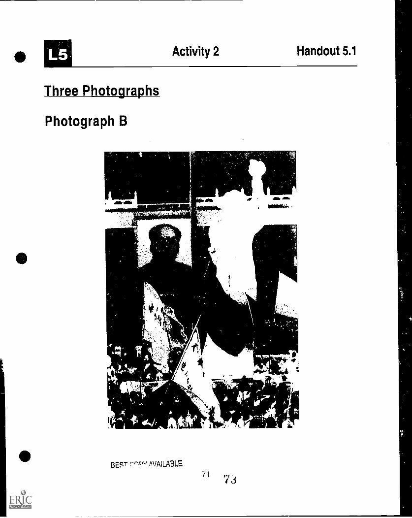
Activity 2 Handout 5.1
Three Photographs
Photograph B
41 , , -
4 i.' 4
Ar
s 7 c1, . . . ^ ;
4*,.
4
BEST -srscl" AVAILABLE
71

L5 Activity 2 Handout 5.1
Three Photographs
Photograph C
1; "e4T,,, ---- ------
72
i
owe. tenr 1^'""
BEST COPY AVAILABLE
I-5 Activity 2 Worksheet 5.1
Analysis of Three Photographs
PhotographA
PhotographB
PhotographC
i BID are theprincipal actors?
2. What ishappening?
3. Mere is this eventtaking place(what country)?
4. When did this eventhappen?

Activity 2 Worksheet 5.1
Analysis of Three Photographs Key
PhotographA
PhotographB
PhotographC
1. Who are the East and West Berliners Chinese Universitystudents
Boris Yeltsinprincipal actors?
2. What ishappening?
the Berlin Wall is beingtorn down and peopleare crossing through it
pro-democracydemonstration
Yeltsin is speaking outagainst coup
3. Where is this event Germany (Berlin) China (TianamenSquare)
Russia (Moscow)taking place(what country)?
4. When did this event 1989 1989 1991
happen?
74
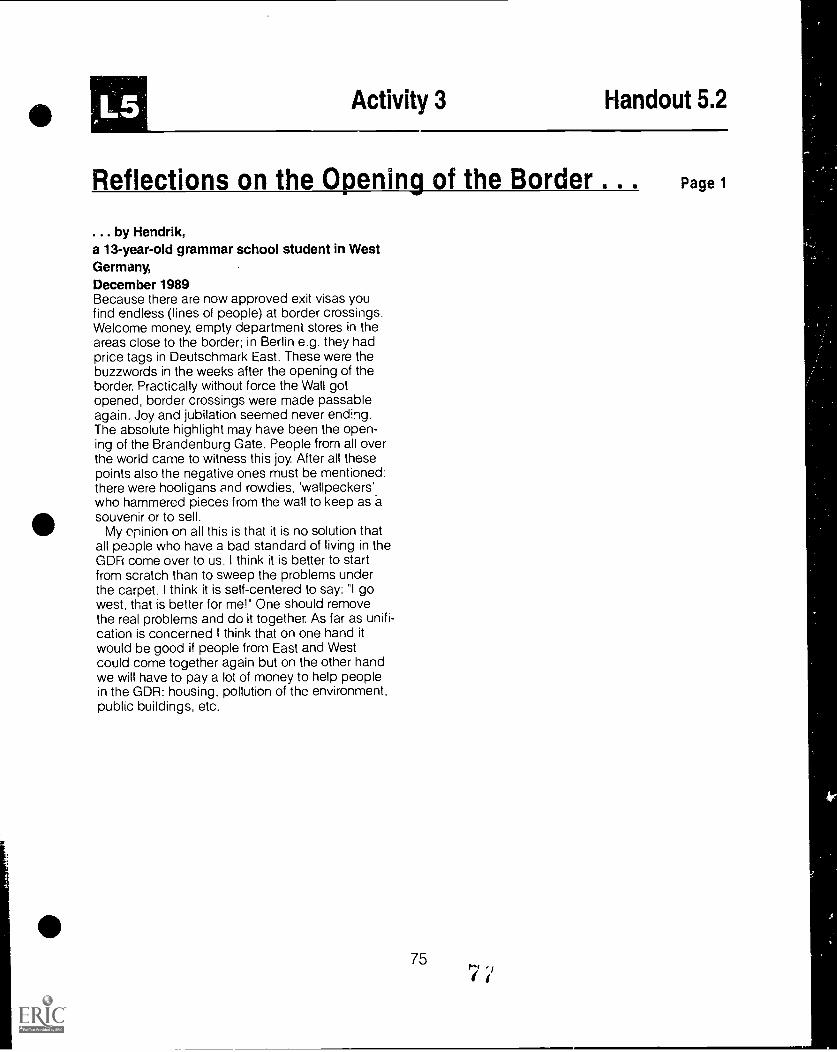
al Activity 3 Handout 5.2
Reflections on the Opening of the Border . . . Page 1
... by Hendrik,a 13-year-old grammar school student in WestGermany,December 1989Because there are now approved exit visas youfind endless (lines of people) at border crossings.Welcome money, empty department stores in theareas close to the border; in Berlin e.g. they hadprice tags in Deutschmark East. These were thebuzzwords in the weeks after the opening of theborder. Practically without force the Wall gotopened, border crossings were made passableagain. Joy and jubilation seemed never ending.The absolute highlight may have been the open-ing of the Brandenburg Gate. People from all overthe world came to witness this joy. After all thesepoints also the negative ones must be mentioned:there were hooligans and rowdies, 'wallpeckers'.who hammered pieces from the wall to keep as asouvenir or to sell.
My opinion on all this is that it is no solution thatall people who have a bad standard of living in theGDR come over to us. I think it is better to startfrom scratch than to sweep the problems underthe carpet. I think it is self-centered to say: "I gowest, that is better for me!" One should removethe real problems and do it together. As far as unifi-cation is concerned I think that on one hand itwould be good if people from East and Westcould come together again but on the other handwe will have to pay a lot of money to help peoplein the GDR: housing, pollution of the environment,public buildings, etc.
757

1113 Activity 3 Handout 5.2
Reflections on the Opening of the Border .
... by Heinz,a West German teacher in his forties,December 1989
Considering the dramatic changes in the GDR, Ihave been particularly struck by the pictures oftens of thousands of refugees from GDR, the cor-dial welcomes at border crossings and railway sta-tions, and by the moving scenes at the opening ofthe Berlin Wall and the Brandenburg Gate, all ofwhich displayed a feeling of belonging togetherwhich nobody had thought possible.
Forty years of division and separation have notbeen able to prevent or diminish the wish for unifi-cation. This feeling and this wish exist on bothsides of the border. That this feeling of together-ness is beginning to be replaced by scepticismon this side is due to the fact that many peopleare beginning to realize that emotions are not suffi-cient to integrate new citizens.
Two thousand new arrivals from the GDR arehaving an effect. The housing market is absolutelyempty. The situation with 2,000,000 structurally un-employed is very tense, social support for new ar-rivals is tearing holes in budgets of federal, state,and local governments. Now many people believethat it is not fair for the GDR refugees to get pref-erential treatment with jobs and housing. Somesort of "social envy" is beginning to have aneffect . .
Personally I am struck by the following:how the speed of events obviously also fa-vors undifferentiated, quick fixes.how at present a feeling of congratulatingoneself, of being with the winner, is being ar-ticulated.how much conceit and condescensionthere is in recommending to people in EastGermany what is hood for them. We nowsomewhat playing the part of the Americansafter 1945, the "rich uncle from the West";there seems to be an FRG "Marshall Plan"for a profitable takeover of still a relativelywhite spot on the map for investments ofWest German industry with an expectedhigh profit margin.how smugly the market system is againhailed as the only successful one as if the
Page 2
last thirty years have not shown with greatclarity how we are in the process of irre-versibly destroying the living conditions offuture generations through the "capitalist"ways of production, of consumption, of en-ergy wasting, of environmental destruction,of dulling people via media, of profitablesale of drugs, of violence, of technology, etc.how the timid attempts of talking about alter-natives are being discredited by pointing tothe normative power of all events: "As every-one can see there is no functioning social-ism." . . .
Internationally people are rediscovering the fearof a Germany wnich could play an all-powerfuleconomic and political role in Europe; on the otherhand they are expecting Germany to play agreater role in solving the world's problems.Vaclav Havel, the writer and current President ofthe. CSR, comments that "Whether Germany has60 or 80 million people, is not the point. If thisdemocratic and social state is based on the ruleof law, we need not be afraid of unified Germany".
[The current period isj characterized by new"openness." Open for quite new and unthoughtforms of integration and international under-standing, but also under threat from old politicalstructures, economic interests and a fundamental-ist consciousness that is closed to the necessityof new global thinking. Now that old images ofenemies which legitimized the arms race havebecome obsolete, mankind could now concen-trate on that which really is existential, i.e. se-curing our existence. The changes in Central andEastern Europe could be the start of a new phaseof securing global peace and global resources.
76
7'

L5 Activity 4 Handout 5.3
Reflections of East German Teacherson Unification, July 1991
The following excerpts are from travel diaries of a group of American educators who visited Germany inJune-July. 1991. They spent most of their time in Saxony- Anhalt, a former east German state that borderedWest Germany. They were hosted by German teachers of English (many of whom also taught Russian).
1. Halberstadt teacher and wife of an architect"I was not allowed to have contact [travel out-side the GDR] with my colleagues in otherplaces. I'll never forgive them for that for allthe years I lost... I received a magazine fromfriends in the USA. The Stasi [secret police]found out and came to my house and took it.They told me never to communicate with thesepeople again. I didn't until 'the change' fiveyears later. My friends thought I was dead."There was a sadness in her voice, but also joyas she recounted her story.
2. A male teacher from Magdeburg in his lateforties"I remember going to Berlin and walking up tothe Brandenburg Gate and looking over toWest Berlin.." His face filled with emotion, hiseyes became tearful and his voice trailed off.He then recalled his elation when he heard theWall had come down, and his first experiencein revisiting the Brandenburg Gate and walkingthrough it from East Berlin to West Berlin. "It ishard to describe in words the feelings one hasat a time like that," he said.
3. On a journey across the Harz Mountains, aformer East German woman recalls hergrandfather's longing for a united Germany"We are German and we must be united," sherecounted. With sadness in her voice she said,"He died before he could see the unification".
4. A woman from Halberstadt, married, nochildren"My husband and I drove to Goslar [a West Ger-man town across the border] after the fall of theWall in November and just prior to Christmas.We stood in the town center. There was a tallChristmas tree; the smell of roasting nuts in theair; snow was falling; and the shop windowswere filled with all kinds of marvelous goodsthings we had never seen before and never
77
dreamed we could buy. We thought we were infairyland."
5. A male local government official from Halber-stadt"With the push of button, everything in easternGermany must be like in West Germany, whereit has taken 40 years to develop.. . Democ-racy only lives at the local level."
6. A 59-year-old woman teacher, unmarried,nearing retirement"Many people [in East Germany] would ratherhave had two Germanies, but unification was anecessity"
7. Halberstadt teacher, married, in her fifties"From the cradle to the grave we were takencare of by the government. Now we don't knowhow to make decisions for ourselves."
8. A male school headmaster from Magdeburg"The psychological walls are higher than theWall."
A visiting American's summary observation'In one respect the East Germans traded se-curity for freedom. The change brought politicalfreedom, but the change is painful for manywho have lost economic and social security. Un-employment is high and will get higher. Someformer East Germans feel their system hadsome desirable features and they should havebeen able to retain those, but the West Ger-mans have required that things be done in theformer eastern states as they are in the rest ofthe FRG. Although not all acknowledge itopenly, some do express the view that they feellike second-class citizens."
73
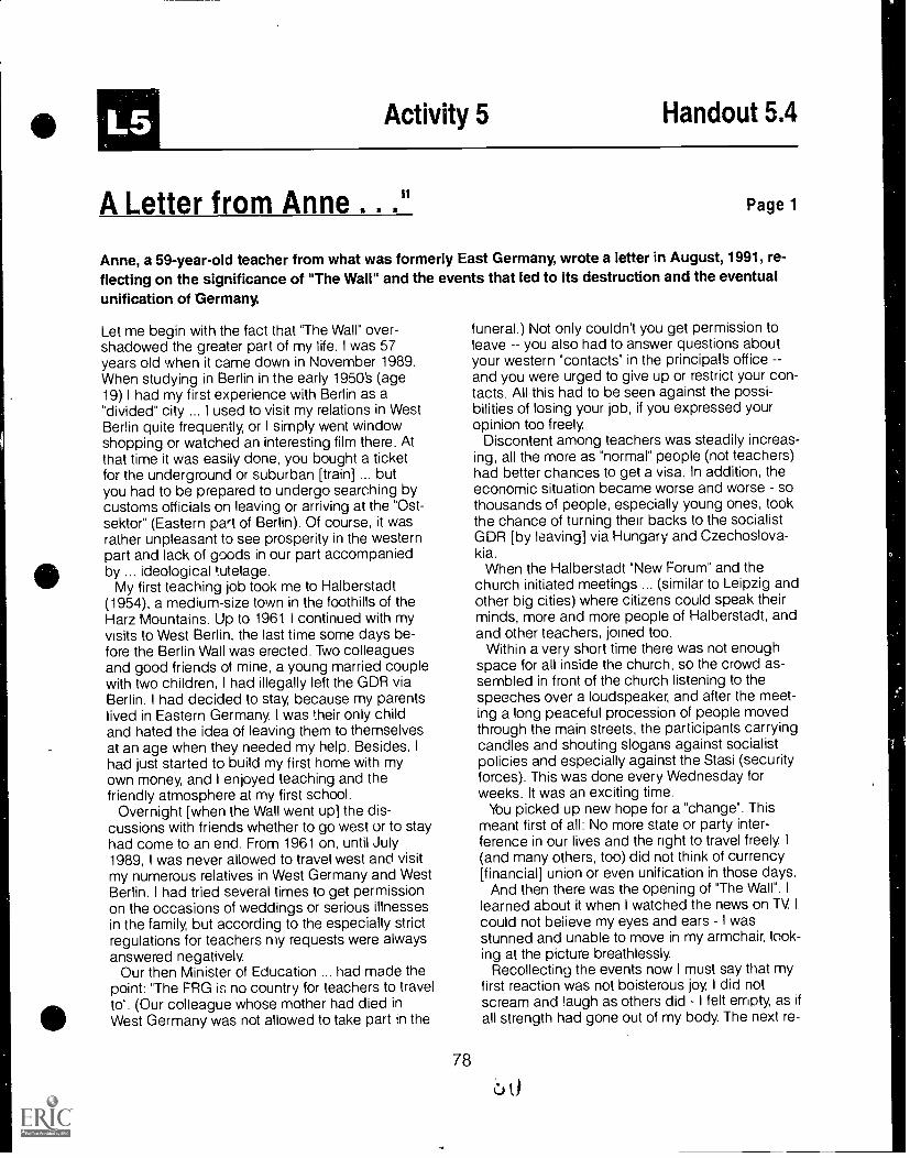
L5 Activity 5 Handout 5.4
A Letter from Anne . ." Page 1
Anne, a 59-year-old teacher from what was formerly East Germany, wrote a letter in August, 1991, re-flecting on the significance of "The Wall" and the events that led to its destruction and the eventualunification of Germany.
Let me begin with the fact that The Wall" over-shadowed the greater part of my life. I was 57years old when it came down in November 1989.When studying in Berlin in the early 1950's (age19) I had my first experience with Berlin as a"divided" city ... I used to visit my relations in WestBerlin quite frequently, or I simply went windowshopping or watched an interesting film there. Atthat time it was easily done, you bought a ticketfor the underground or suburban [train] ... butyou had to be prepared to undergo searching bycustoms officials on leaving or arriving at the "Ost-sektor" (Eastern part of Berlin). Of course, it wasrather unpleasant to see prosperity in the westernpart and lack of goods in our part accompaniedby ... ideological tutelage.
My first teaching job took me to Halberstadt(1954), a medium-size town in the foothills of theHarz Mountains. Up to 1961 I continued with myvisits to West Berlin, the last time some days be-fore the Berlin Wall was erected. Two colleaguesand good friends of mine, a young married couplewith two children, I had illegally left the GDR viaBerlin. I had decided to stay, because my parentslived in Eastern Germany. I was their only childand hated the idea of leaving them to themselvesat an age when they needed my help. Besides, Ihad just started to build my first home with myown money, and I enjoyed teaching and thefriendly atmosphere at my first school.
Overnight [when the Wall went up] the dis-cussions with friends whether to go west or to stayhad come to an end. From 1961 on, until July1989, I was never allowed to travel west and visitmy numerous relatives in West Germany and WestBerlin. I had tried several times to get permissionon the occasions of weddings or serious illnessesin the family, but according to the especially strictregulations for teachers my requests were alwaysanswered negatively.
Our then Minister of Education ... had made thepoint: "The FRG is no country for teachers to travelto". (Our colleague whose mother had died inWest Germany was not allowed to take part in the
78
funeral.) Not only couldn't you get permission toleave you also had to answer questions aboutyour western "contacts" in the principal's officeand you were urged to give up or restrict your con-tacts. All this had to be seen against the possi-bilities of losing your job, if you expressed youropinion too freely.
Discontent among teachers was steadily increas-ing, all the more as "normal" people (not teachers)had better chances to get a visa. In addition, theeconomic situation became worse and worse sothousands of people, especially young ones, tookthe chance of turning their backs to the socialistGDR [by leaving] via Hungary and Czechoslova-kia.
When the Halberstadt "New Forum" and thechurch initiated meetings ... (similar to Leipzig andother big cities) where citizens could speak theirminds, more and more people of Halberstadt, andand other teachers, joined too.
Within a very short time there was not enoughspace for all inside the church, so the crowd as-sembled in front of the church listening to thespeeches over a loudspeaker, and after the meet-ing a long peaceful procession of people movedthrough the main streets, the participants carryingcandles and shouting slogans against socialistpolicies and especially against the Stasi (securityforces). This was done every Wednesday forweeks. It was an exciting time.
You picked up new hope for a "change". Thismeant first of all: No more state or party inter-ference in our lives and the right to travel freely. I(and many others, too) did not think of currency[financial] union or even unification in those days.
And then there was the opening of "The Wall". Ilearned about it when I watched the news on TV. Icould not believe my eyes and ears I wasstunned and unable to move in my armchair, look-ing at the picture breathlessly.
Recollecting the events now I must say that myfirst reaction was not boisterous joy, I did notscream and laugh as others did I felt empty, as ifall strength had gone out of my body. The next re-
Activity 5 Handout 5.4
A Letter from Anne ..."
action resulted in a question to myself: How longwill it last?
Thousands of people rushed to their cars theywanted to cross the borderline (which is about 30km away from Halberstadt) and found themselvesin a long, long queue. My neighbors after waitingthree hours in the exhaust gases gave up. Theirchildren stayed on and were successful after fourhours and passed thiuugh crowds of [West Ger-mans] applauding and throwing bottles of cham-pagne into the "Trabis" [East Germans' auto]. Oneof my younger colleagues managed to get fromHalberstadt to the Dutch frontier and back overthis weekend ... I stayed at home watching the
Page 2
touching scenes between people of the two Ger-manies on TV. My first border crossing took placetwo weeks later. I visited a cousin in West Berlin. Ittook me about half an hour (as in the 1950S) toreach her apartment including passport controland the trip by suburban train. She had been aschool girl when I had met her the last time in herparents' home.
Now I can travel west any time I like (if I have themoney). In the remaining years of my life I will tryto fill at least some of the gaps in my knowledge ofGermany to get an impression of what my homecountry is like.
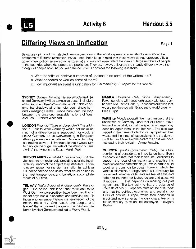
Activity 6 Handout 5.5
Differing Views on Unification Page 1
Below are opinions from 3lected newspapers around the world expressing a variety of views about theprospects of German unification. As you read these keep in mind that these views do not represent officialgovernment policy (an exception is Izvestia) and may not even reflect the views of large numbers of peoplein the countries where the papers are published. They do, however, illustrate the sharply different views thatthoughtful people hold. As you read the comments consider the following questions:
a. What benefits or positive outcomes of unification do some of the writers see?b. What concerns or worries some of them?c. How important an event is unification for Germany? for Europe? for the world?
SYDNEY Sydney Morning Herald (moderate): [Aunited Germany] will be a massive beast, invincibleat the summer Olympics and an unmatchable econ-omy that shadows all of its neighbors, single-han-dedly wedging Central Europe back onto the mapbetween the once-unchangeable notion s of Westand East. --Robert Whitehad
LONDON Financial Times (independent): The addi-tion of East to West Germany would not make asmuch of a difference as is supposed; nor would aunited Germany be as overwhelming in Europeanaffairs as some peocie believe. ...Modern Germanyis a trading power. It is improbable that it would turnits back on the huge markets of the West to pursuea will-o'-the- wisp in the East. --Martin Wolf
BUENOS AIRES La Prensa (conservative): The So-viet leaders are resignedly presiding over the inevi-table liquidation of the empire they inherited... Thereis every reason for the German nation to achievefull independence and union, what could be one ofthe most transcendent and beneficial accomplish-ments of our time.
TEL AVIV Yediot Achronot (independent): The slo-gan, One nation, one land," that more and moreWest German personalities have been reciting inrecent days has a discordant and terrifying ling. Tothose who remember history, it is reminiscent of thebestial battle cry, "One nation, one people, oneleader," that expressed the goals of expansion har-bored by Nazi Germany and led to World War II.
MANILA Philippine Daily Globe (independent):Fewer scholars will henceforth speak with total con-fidence of a Pacific Century. There is no question thatwe are not finished with Eurocentric world order.Bias F Opie
PARIS Le Monde (liberal): We must insure that theunification of Germany and that of Europe moveforward in parallel, so that the specter of hegemonydoes not again loom on the horizon... The cold war,waged in the name of ideological sympathies, hasweakened the thrust of nationalisms. It is the duty ofus all to make sure that the end of the cold war doesnot lead to their revival. Andre Fontaine
MOSCOW Izvestia (government daily): The allies'position is of considerable importance here. Bonnevidently realizes that their theoretical readiness tosupport the idea of unification...and practise thisdirection are two different things... We intend to buildtogether a common European home in which thevarious "domestic arrangements" will obviously bepreserved. Whether its tenants will feel at ease andsafe and the need for locked cellars and attics willdisappear . . . that depends on working out jointagreements. The key point is that the balance ofinterests of oth( Europeans must not be disturbed:and that the political, economic, and social struc-tures of postwar Europe, which took decades toerect and now serve as the only guarantee of itsfuture security, must not be destroyed. --YevgenyBovkun
808

Activity 6 Handout 5.5
Differing Views on Unification
ISTANBUL Milliyet (liberal-reformist): The mergingof the Germanies would create a new superpower inWestern Europe. All balances and areas of influencedesigned at Yalta would change. It is unclear howthis process of stupefying speed will end. These arethe possibilities that terrify the West.
TURIN La Stampa (liberal): History, that great joker,is laughing.at all of those who so boldly announcedits end. German reunification, a theme that seemedto have been mummified and buried, is resurfacing.Those in the West are least prepared for this, be-cause they have always talked about unification, butrarely thought about it. The Soviet leaders are betterprepared, having thought about it a lot without say-ing much. But all have been caught off-guard by theaccelerating events . . .
No, history has not ended. --Barbara Spinelli
Page 2
HAMBURG Die Zeit (liberal weekly): Even those whofind themselves unable to accept two Germaniesknow perfectly well that, even in the best of allpossible worlds, unity will come at the end of a long,long development that has only just begun; that itmust not be allowed to occur under conditions thatwould tear us from the chains that have anchored usin the Atlantic and European communities fromwhich, in past decades, we have found protectionand support. It is also clear that unification willprobably occur far more loosely than was the casewith the German Reich that existed from 1871 to1945 . . . And it is even clearer that the Germanquestion does not belong to Germans alone. --TheoSommer
views reported in World Press Review, 37, No. 1, (January 1990), pp. 20-21.
i

Landforms. Rivers and Canals Transparency 2
Moselle
r
0
Oder-Spreeal
North GermanPlain
Sub-alpineRegion
Foothillsof the Alps
Alps
00
BEST COPY AVAILABLE

Important Industrial Areas and Location of Mineral Resources Transparency 3
Lignite Coal
oil
BEST COPY AVAILABLE

Types of IndustriesTransparency 4
The Ruhr Region
Emden;
idol& .7.
'- ShipbuildingIron and Steel
Industry
c). Electncal Industry
Chemical Industry
4* Mining
AP Truck Manufacturing
Automobilemiak.ManufaGiuring
BEST COPY AVAILABLE
EQ.pulation Density Transparency 5
Population/=- approximately
79 Million
Area::40 357,046 km2
Federal Republicof Germany
United Statesof America
AlabamaGeorgiaSouth Carolina
Populationapproximately255 Million
Area:9,372,619 km2
Populationapproximately114 Million
Total Area:367,073 km2
b0BESTeePVATIMLE
222 Inhabitantsper km2
27 Inhabitantsper km2
38 Inhabitantsper km2
Land Use
Lasisght
-1,..."."1",")
:114;4.41ir el. r. 0"
Transparency 6
0 . # .. %:. :;::aII . 0 .. ... ...... It , 0.
4.. .. . .ft * 4. - vo . .O. . .. ,e .e .,.... ,..
" r , -. . "" . ; ,.e 00 * 40 e
. .0 ,., $ ..ir r ..,,11111r_
lit=
1411* -"di
it
Land Used Rivers, Lakesfor Agriculture Buildings Streets Parks
Forest
Excavated
constructionWombs
IndustrialWes%2.3 Sludge23 Mc.
BEST CCPY AVATENBEE

International Commerce Transparency 7

Foreigners in Germany Transparency 8

German Unity Transparency 9
t.
IIIHOP00/0.aim -..00111IL
011
Schweri
/nom t
Berlin
Potsdam
Magdeburg
Erfurt
VIM
12
Berlin until 3 October, 1990
BEST COPY AVAILABLE
The German Language Transparency 10
Rostock
t It0101Clilan-i NI* ?oilletatliall000
I1
DIN GERMANt,, Iso''''''/Ian ........
. sz0AHalt Nit
...% Berlin ei,
1-' ..b.,._.....,,_/
) .........,, ,.........../
16 --.....-"'". Leipzig
z...-N EAST MIDDLE GERMAN:-y Erfurt
)---. ThuringianA .
.J---Jo
Polish
*Prague
ItalianBEST COPY AVAILABLE

Radio and Television Transparency 11
Irow. dmolIP".
411". -...._
II
4--
SATtl
asot
Ir
ZIF
,1
..-.-al
r
gee'wry
rte4r
BEST COPY AVAILABLE

The Federal States of Germany Transparency 12
0
O
Mecidenburg-Schwerin Western
PomeraniaHamburg AL
Bremen
Lower Saxony
Hanover PoMagdeburg
North Rhine- Saxony-Westpl* Anhalt
Duessidod
Rhineland-Palatinate
Mainz
Saarlandken
Stuttgart
Wuerttem berg
7111"rMrCbt
SaxonyDresden


![Hp inc[553]](https://img.pdfslide.us/doc/110x75/58cef4ee1a28abab738b4c8b/hp-inc553.jpg)