Embed Size (px)
Citation preview
Assessment of the status of thedevelopment of standards for the Terrestrial
Essential Climate Variables
63
Essential Climate Variables
GTOS
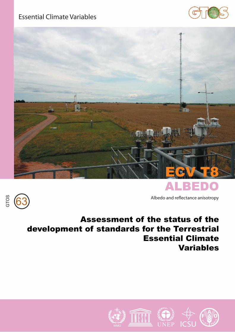
ALBEDO Albedo and reflectance anisotropy
ECV T8
GTOS Secretariatc/o Environment, Climate Change and Bioenergy Division (NRC) Food and Agricolture Organization of the United NationsViale delle Terme di Caracalla 00153 Rome, Italye-mail: [email protected] Tel: (+39) 06 57056804 Fax: (+39) 0657053369 www.fao.org/gtos

ECV T8: Albedo and reflectance anisotropy
Assessment of the status of the development of standards for the
Terrestrial Essential Climate Variables
Lead author: Crystal Barker Schaaf
Contributors: Josef Cihlar, Alan Belward, Ellsworth Dutton and Michel M. Verstraete
ECV reports coordinator: Reuben Sessa
Draft version 10
22 November 2008
63
Global Terrestrial Observing System, Rome, 2008
PLEASE NOTE THAT THE CURRENT DOCUMENT IS A DRAFT WHICH IS UNDER REVIEW. A FINAL DOCUMENT WILL BE SUBMITTED AT SBSTA 30

2
E C V T 8 : A s s e s s m e n t o f S t a n d a r d s f o r t h e A l b e d o C l i m a t e V a r i a b l e T8
GTOS Secretariat NRC, Food and Agriculture Organization of the United Nations (FAO) Viale delle Terme di Caracalla, 00153 Rome, Italy Tel.: (+39) 06 57055547 Fax: (+39) 06 57053369 E-mail: [email protected]
3
E C V T 8 : A s s e s s m e n t o f S t a n d a r d s f o r t h e A l b e d o C l i m a t e V a r i a b l e T8
Contents
Acronyms .................................................................................................................................. 4
Executive Summary.............................................................................................................. 5
1. Introduction ........................................................................................................................ 7
2. Definition and Units ......................................................................................................... 8
3. Existing Measurement Methods and Standards ................................................... 8
3.1 In situ Observations ................................................................................................. 8
3.2 Remotely Sensed Observations ........................................................................... 9
3.3 Summary of requirements and gaps ............................................................... 10
4. Contributing networks and agencies ...................................................................... 11
5. Available data .................................................................................................................. 11
5.1 In situ ........................................................................................................................... 11
5.2 Satellite observations............................................................................................. 12
6. Other issues ..................................................................................................................... 12
7. Conclusions ....................................................................................................................... 13
8. Recommendations ......................................................................................................... 13
References.............................................................................................................................. 14
4
E C V T 8 : A s s e s s m e n t o f S t a n d a r d s f o r t h e A l b e d o C l i m a t e V a r i a b l e T8
Acronyms BHR Bi-Hemispherical Reflectance BRDF Bidirectional Reflectance Distribution Function BSRN Baseline Surface Radiation Network CEOS Committee on Earth Observing Satellites DHR Directional Hemispherical Reflectance GCOS Global Climate Observing System TCO Terrestrial Carbon Observation WGCV Working Group on Calibration and Validation WMO World Meteorological Organization
5
E C V T 8 : A s s e s s m e n t o f S t a n d a r d s f o r t h e A l b e d o C l i m a t e V a r i a b l e T8
Executive Summary Land surface albedo, or the ratio of the radiant flux reflected from the Earth’s surface to the incident flux, is a key forcing parameter controlling the planetary radiative energy budget and partitioning of radiative energy between the atmospheric and surface. Albedo varies in space and time as a result of both natural processes (e.g. solar illumination, snowfall and vegetation growth) and human activities (e.g. clearing and planting forests, sowing and harvesting crops, burning rangeland) (GCOS 2004) and is a sensitive indicator of environmental vulnerability. Since albedo depends on both the unique anisotropy of the surface (related to the intrinsic composition and structure of the land cover) and the atmospheric condition at any given time, field tower measurements support local and regional determination of surface albedo while remote sensing offers the only viable method of measuring and monitoring the global heterogeneity of albedo and reflectance anisotropy (GCOS 2004). Broadband surface albedo is generally defined as the instantaneous ratio of surface-reflected radiation flux to incident radiation flux over the shortwave spectral domain (dimensionless). It can be defined for broad spectral regions or for spectral bands of finite width. Albedo measures include black-sky albedo (or directional hemispherical reflectance, DHR) defined in the absence of a diffuse irradiance component (no atmospheric scattering), wholly diffuse white-sky albedo (or bihemispherical albedo, BHR, under isotropic illumination), and actual or blue-sky albedo (BHR under ambient conditions). GCOS (2004) has specified black-sky albedo as the product required for climate change purposes. Since the DHR is a function of the solar zenith angle, it is usually computed for a specific time (e.g. local solar noon). Direct solar radiation (total or spectral) at the surface is measured by means of pyrheliometers, the receiving surfaces of which are arranged to be normal to the solar direction. Pyranometers are used to measure global radiation (direct plus diffuse) or diffuse only radiation in the spectral range from 0.3 to 3.0 micrometres (WMO 2006). The WMO guidelines are used by the Baseline Surface Radiation Network (BSRN), which has been established to provide continuous, long-term tower measurements of surface radiation fluxes adhering to the highest achievable standards of measurement procedures (McArthur, 2005). The BSRN data, archived at World Radiation Monitoring Center at the Alfred Wegener Institute, Bremerhaven, Germany, is now recognized as the GCOS baseline network for surface radiation (GCOS 2004). These BSRN sites provide the high-quality measurements of surface radiation required, but the network global coverage is insufficient for widespread validation of remotely sensed products and needs to be expanded and adequately supported (GCOS, 2004a). In addition to the BRSN, other terrestrial networks contain tower sites that could provide the necessary infrastructure (e.g. human maintenance, instrument availability, site accessibility, and power needs) to measure radiation variables for albedo calculations; the challenges in these cases are to encourage the use of best practice measurement, calibration and archive protocols, and provide timely access. Guidelines for data collection protocols and standardization across the flux networks are currently being developed under the auspices of the Terrestrial Carbon Observation (TCO) effort. However, many such flux and ecological
6
E C V T 8 : A s s e s s m e n t o f S t a n d a r d s f o r t h e A l b e d o C l i m a t e V a r i a b l e T8
networks are part of national research programmes without guaranteed adequate long-term funding. To estimate remotely sensed albedo, reflectance measurements must be interpreted with the help of radiation transfer models that can help retrieve the desired variables from the actual observations (GCOS 2006). Most satellite algorithms rely on multiple cloud-free directional satellite observations to first determine a bi-directional reflectance distribution function (BRDF) model of the surface. The model is then angularly integrated to determine the reflected shortwave flux. Because most sensors do not collect multiple observations of a target in a single pass, data from multiple orbits or acquisition times may be used, and the varying atmospheric and irradiance effects then need to be reconciled. GCOS (2006) suggested that albedo product requirements may be met through a combination of satellite sensors, both geostationary (with wide coverage and good temporal resolution) and polar orbiting (with uniform coverage of the globe, important especially for polar regions). Because of the differences in sensors and observation conditions (orbit geometry, season, geographic region, land cover characteristics), albedo product generation procedures tend to differ depending on the specific product, the data source, and the producing organization. For climate change purposes, long time series of products are especially important, and this inevitably imposes the necessity for consistency among products from satellite missions flown at different times. The validation of satellite-derived products for heterogeneous land surfaces poses special challenges because of the need to obtain estimates of “true” instantaneous albedo to be compared with satellite-derived values. Various upscaling methods have been utilized, ranging from the use of in situ measurements to the use of higher resolution satellite data and models. Such validation exercises and rigorous satellite product intercomparisons are facilitated by the various space agencies and the Land Product Validation Subgroup of the Committee on Earth Observing Satellites/Working Group on Calibration and Validation (CEOS/WGCV) to promote consensus procedures (GCOS 2004). Recommendations
Official recognition of the need for long-term, high-quality, in situ radiation measurements for spectral and broadband albedo determination is required so that field measurements can be expanded to cover a greater diversity of land covers and ecosystems, both in existing radiation networks (such as BSRN) and in other terrestrial networks with sufficient pre-existing infrastructure. Such measurements should conform to WMO and BSRN guidelines (WMO, 2006; McArthur, 2005). The further development, validation and intercomparison of satellite-derived albedo and reflectance anisotropy products should be vigorously pursued to establish the accuracy and consistency of these critical geophysical quantities and to guarantee the production of similarly high calibre data sets from future sensors. It must be recognized that periodic reprocessing of existing archives of remote sensing data will be necessary to generate the continuous and consistent long-term global climate records required.

7
E C V T 8 : A s s e s s m e n t o f S t a n d a r d s f o r t h e A l b e d o C l i m a t e V a r i a b l e T8
1. Introduction Land surface albedo, or the ratio of the radiant flux reflected from the Earth’s surface to the incident flux, is a key forcing parameter controlling the planetary radiative energy budget and the partitioning of radiative energy between the atmospheric and surface. The energy absorbed at the surface is used to drive vegetation processes such as evapotranspiration, photosynthesis and carbon assimilation, and govern temperature-related processes such as evaporation, and snow melt (Pinty, et al., 2008). Thus albedo varies in space and time as a result of both natural processes (e.g., changes in solar position, snowfall, inundation and vegetation growth) and human activities (e.g., clearing and planting forests, sowing and harvesting crops, burning rangeland) and is a sensitive indicator of environmental vulnerability (GCOS, 2004). Consequently, long-term surface albedos of the global landmass are required by climate, biogeochemical, hydrological, and weather forecast models at a range of spatial (from a few hundred meters to 30km) and temporal (from daily to monthly) scales. Albedo depends on both the unique anisotropy of the surface (related to the intrinsic composition and structure of the land cover) and the atmospheric condition at any given time. In situ tower measurements support local and regional determination of surface albedo while remote sensing offers the only viable method of measuring and monitoring the global heterogeneity of albedo and reflectance anisotropy (Schaaf et al., 2006). Long-term, high-quality, calibrated field measures of direct and diffuse land surface incident and reflected radiation are being collected from tower-mounted pyranometers at a limited number of sites by the Baseline Surface Radiation Network (BSRN). The BSRN, with its standardized measurement protocols, has already been designated by the World Climate Research Programme (WCRP) as the global baseline network for surface radiation for the Global Climate Observing System (GCOS). Additional reflected radiation measurements are frequently collected by International Long Term Ecological Research (ILTER) sites and regional flux tower networks (such as Ameriflux, Asiaflux, Fluxnet-Canada, CarboEurope, etc.). Guidelines for data collection protocols and standardization across the flux networks are being developed under the auspices of the Terrestrial Carbon Observation (TCO) effort. Directional satellite observations are currently being utilized from a number of instruments (e.g. MODIS (MODerate resolution Imaging Spectroradiometer), MISR (Multi-angle Imaging SpectroRadiometer), CERES (Clouds and the Earth’s Radiant Energy System), POLDER (Polarization and Directionality of the Earth’s Reflectances), MERIS (Medium Resolution Imaging Spectrometer), Meteosat, and MSG (Meteosat Second Generation) to provide routine regional and global operational albedo products at a variety of spatial and temporal resolutions. The challenge for the remote sensing community is to provide consistent high-quality, high resolution, global land albedo data sets over a sufficient period of time to constitute stable records for the modeling and climate diagnostics communities. Data quality assessments, field validation exercises, and product intercomparisons are routinely carried out by the respective science teams and these efforts are endorsed and facilitated by the Land Product Validation subgroup of the Committee on Earth Observing Satellites/Working Group on Calibration and Validation (CEOS/WGCV).
8
E C V T 8 : A s s e s s m e n t o f S t a n d a r d s f o r t h e A l b e d o C l i m a t e V a r i a b l e T8
2. Definition and Units Broadband surface albedo is generally defined as the instantaneous ratio of surface-reflected radiation flux to incident radiation flux over the shortwave spectral domain (dimensionless). It can be defined for broad spectral regions or for spectral bands of finite width. Since the scattering of light by land surfaces also depends on the direction of incoming radiation and the direction of observation, various albedo concepts have been introduced: white-sky (bi-hemispherical reflectance under isotropic illumination, BHRiso), black-sky (directional hemispherical reflectance, DHR under direct illumination), blue-sky (bi-hemispherical reflectance approximating ambient illumination and instantaneous atmospheric conditions, BHR), (Schaepman-Strub et al., 2006; Baret et al., 2005; Pinty et al.,2005 ). Among the above definitions, GCOS (2004a) specified back-sky albedo as the product required for climate change purposes. Black-sky albedo is defined as albedo in the absence of a diffuse irradiance component (no atmospheric scattering). Since the DHR is a function of the solar zenith angle, it is usually computed for a specific time (such as local solar noon). Albedo products should be specified with a relative accuracy of 5% (or 0.005, whichever is larger), a horizontal resolution of 1km, a daily observing cycle, and a stability of 1% (GCOS, 2006).
3. Existing Measurement Methods and Standards
3.1 In situ Observations Direct solar radiation (total or spectral) at the surface is measured by means of pyrheliometers, the receiving surfaces of which are arranged to be normal to the solar direction. Temporal requirements for irradiance and radiant exposure range from seconds and minutes (for some energy applications) to hourly and daily for forecast, modeling, and monitoring needs (WMO, 2006). Pyranometers are used to measure global radiation (direct plus diffuse) or diffuse only radiation in the spectral range from 0.3 to 3.0 micrometres (WMO, 2006). The WMO guidelines are used by the Baseline Surface Radiation Network (BSRN; Ohmura et al., 1998; McArthur, 2005) to provide continuous, long-term measurements of surface radiation fluxes adhering to the highest achievable standards of measurement procedures. The BSRN data, archived at World Radiation Monitoring Center at the Alfred Wegener Institute, Bremerhaven, Germany, is now recognized as the GCOS baseline network for surface radiation (GCOS, 2004). Among the more than 40 active stations, only 15 currently also measure reflected radiation (Rosch, 2005) and thus provide data at a high temporal resolution throughout the day for albedo calculations. While these spatially-limited BSRN tower sites provide the highest-quality measurements available of radiation at the surface, the network needs to be expanded and adequately supported to achieve a more representative global coverage (GCOS, 2004a).
9
E C V T 8 : A s s e s s m e n t o f S t a n d a r d s f o r t h e A l b e d o C l i m a t e V a r i a b l e T8
In addition to the BRSN, and national programmes that contribute to BSRN such as NOAA SURFRAD and DOE Atmospheric Radiation Measurement (ARM) efforts, other terrestrial research networks include appropriate tower sites with the necessary infrastructure (e.g. human maintenance, radiation instrument availability, site accessibility, and power needs) to measure radiation variables for albedo calculations. The challenges in these cases are to encourage the use of best practice measurement, calibration and archive protocols as epitomized by BSRN, and provide timely access (Baret et al., 2005). In addition to radiation measurements, vital atmospheric state measurements needed to correlate surface and satellite-based quantities are also collected at many of these sites as part of regional or global meteorological or atmospheric networks contributing to the WMO/GAW- Global Atmospheric Watch (such as the Aerosol Robotic NETwork - AERONET). However, many such atmospheric, flux, and ecological research networks are part of national research programs without the guaranteed and adequate funding necessary for long-term measurements. Thus, while these surface measurements are currently insufficient to systematically validate remote sensing products in a global sense, they do complement a range of scientific efforts aiming at comparing and benchmarking the various albedo products currently being generated. Pursuing these activities will be essential to ensure the quality and reliability of future products, as a step towards more accurate and consistent albedo information for the global landmass and the development of associated standards.
3.2 Remotely Sensed Observations
Albedo and reflectance anisotropy products with spatial resolutions of 250m to 20km and temporal frequencies of daily to monthly are now routinely derived from sensors on polar orbiting satellites such as MODIS (Gao et al., 2005; Schaaf et al., 2002; Lucht et al.,2000), MISR (Martonchik et al., 2002; Martonchik et al., 1998a;b), CERES (Rutan et al., 2006), POLDER (Leroy et al., 1997; Hautecoeur and Leroy, 1998; Bicheron and Leroy, 2000; Maignan et al., 2004; Bacour and Breon, 2005) and MERIS (J.-P. Muller, 2008) and from geostationary satellites such as Meteosat (Pinty et al., 2000a;b; Govaerts et al., 2004; 2006), and MSG (van Leeuwen and Roujean, 2002; Geiger et al., 2005) To estimate surface albedo on the basis of remotely sensed data, reflectance measurements must be interpreted with the help of radiation transfer models that can help retrieve the desired variables from the actual observations (GCOS, 2006). Most satellite algorithms rely on multiple cloud-free atmospherically-corrected directional satellite observations to first determine an appropriate bi-directional reflectance distribution function (BRDF) model of the surface. The model is then angularly integrated to determine the reflected shortwave flux. Because most sensors do not collect multiple observations of a target in a single pass, data from multiple orbits or acquisition times may be used, and varying atmospheric and irradiance effects must be reconciled. Estimates of instantaneous blue-sky albedo can then be reconstructed from the gridded measurements of the directional hemispherical reflectance factor, the bi-hemispherical reflectance factor and a determination of the fractions of incoming direct and diffuse radiation.
10
E C V T 8 : A s s e s s m e n t o f S t a n d a r d s f o r t h e A l b e d o C l i m a t e V a r i a b l e T8
GCOS (2006) suggested that albedo product requirements may be met through a combination of satellite sensors, both geostationary (with wide coverage and good temporal resolution) and polar orbiting (with uniform coverage of the globe, important especially for polar regions). Because of the differences in sensors and observation conditions (orbit geometry, season, geographic region, land cover characteristics), albedo product generation procedures tend to differ depending on the specific product, the data source, and the producing organization. For climate change purposes, long time series of products are especially important, and this inevitably imposes the necessity for consistency among products from satellite missions flown at different times (Baret et al., 2005; GCOS, 2004a;b; Schaaf et al., 2008; Govaerts et al., 2008). While the product generation methods and algorithms are well documented in most cases, determination of their characteristics (accuracy; consistency over time; compatibility with the same or similar products from different sensors and time periods; etc.) is an area of active research, with plans formulated and some initiatives being undertaken (Baret et al., 2005; GCOS, 2004a;b; Pinty et al., 2004; Schaaf et al., 2008). The validation of satellite-derived products for heterogeneous land surfaces poses special challenges because of the need to obtain estimates of ‘true’ instantaneous albedo to be compared with satellite-derived values. Various upscaling methods have been utilized, ranging from the use of in situ measurements to the use of higher resolution satellite data and models (Barnsley et al., 2002; Liang et al., 2002; Baret et al., 2005; Trishchenko et al., 2005). Such validation exercises and satellite product intercomparisons are being facilitated by the various space agencies and the Land Product Validation subgroup of the Committee on Earth Observing Satellites/Working Group on Calibration and Validation (CEOS/WGCV) to promote consensus procedures and standards.
3.3 Summary of requirements and gaps
The WMO Guide to Meteorological Instruments and Methods of Observation (2006) and the BSRN operations manual (McArthur, 2005) serve as the de facto standards for terrestrial tower based measurements. The frequent observations measured throughout the day provide shortwave albedos under a range of illumination geometries. However, the modelling community is increasingly interested in spectral albedo measurements (including UV and PAR quantities) rather than merely total shortwave values. Thus, in addition to a global increase in the number of high quality tower sites collecting and archiving albedo information, an increased use of spectral radiometers at some of these sites would be of great benefit for regional characterization and satellite product validation. With regards to satellite-based products, virtually all modern albedo datasets now include extensive quality information, access to the underlying spectral anisotropic reflectance model retrievals (the so-called BRDF models), and a program of periodic archive reprocessing to ensure the highest quality remotely sensed products. However it is important to the development of long term climate records from multiple satellite systems to maintain this heritage of high calibre products as new satellite sensors are launched. Thus it is essential that critical measurements continue to be produced with a quality and accuracy at least equal to what can be currently achieved and that the long archives of existing remote sensing data be periodically reprocessed to generate continuous and stable global records over extended periods.

11
E C V T 8 : A s s e s s m e n t o f S t a n d a r d s f o r t h e A l b e d o C l i m a t e V a r i a b l e T8
4. Contributing networks and agencies
Baseline Surface Radiation Network (BSRN) www.bsrn.awi.de/en/home/ www.gewex.org/bsrn.html
National Oceanic and Atmospheric Administration (NOAA) Surface Radiation Network (SURFRAD) www.srrb.noaa.gov/surfrad/
Department of Energy (DOE) Atmospheric Radiation Measurement (ARM) Program www.arm.gov/
International Regional Flux Networks www.fluxnet.ornl.gov/fluxnet/overview.cfm
International Long Term Ecological Research (ILTER) www.ilternet.edu/
National Aeronautics and Space Administration (NASA) Aerosol Robotic Network (AERONET) http://aeronet.gsfc.nasa.gov/
WMO Global Atmosphere Watch (GAW) www.wmo.int/pages/prog/arep/gaw/gaw_home_en.html
NASA Aqua http://aqua.nasa.gov/index.php
NASA Terra http://terra.nasa.gov/
European Space Agency (ESA) Envisat http://envisat.esa.int/
ESA Meteosat Second Generation www.esa.int/msg/pag0.html
European Organisation for the Exploitation of Meteorological Satellites (EUMETSAT) Meteosat www.eumetsat.int/Home/index.htm
French Space Agency CNES (Centre National d’Etudes Spatiales) POLarization and Directionality of the Earth's Reflectances (POLDER) - Polarization & Anisotropy of Reflectances for Atmospheric Sciences coupled with Observations from a Lidar( PARASOL) http://polder.cnes.fr/
Committee on Earth Observation Satellites/Working Group on Calibration and Validation/ Land Product Validation Subgroup (CEOS/WGCV/LPV) http://lpvs.gsfc.nasa.gov/
5. Available data
5.1 In situ
BSRN www.bsrn.awi.de/en/home/
12
E C V T 8 : A s s e s s m e n t o f S t a n d a r d s f o r t h e A l b e d o C l i m a t e V a r i a b l e T8
NOAA SURFRAD www.srrb.noaa.gov/surfrad/
DOE ARM www.archive.arm.gov/armlogin/login.jsp
CERES/ARM Validation Experiment (CAVE) www-cave.larc.nasa.gov/cave/pages/sam.html
International Regional Flux Networks www.fluxnet.ornl.gov/fluxnet/overview.cfm
ILTER www.ilternet.edu/
NASA AERONET http://aeronet.gsfc.nasa.gov/
European Union Joint Research Center (JRC) World Data Centre for Aerosols http://wdca.jrc.it/
5.2 Satellite observations
NASA Moderate resolution Imaging Spectroradiometer (MODIS) Albedo/BRDF http://modis-land.gsfc.nasa.gov/brdf.htm
NASA Multi-angle Imaging SpectroRadiometer (MISR) Level 2 Aerosol/Surface Product: www-misr.jpl.nasa.gov/mission/data/data.html
NASA CERES SARB www-cave.larc.nasa.gov/cave/fsw-sfcalb/
CNES POLDER Albedo, BRDF http://postel.mediasfrance.org/sommaire.php3?langue=English
ESA Medium Resolution Imaging Spectrometer (MERIS) Albedo http://envisat.esa.int/level3/
EUMETSAT Meteosat www.eumetsat.int/HOME/Main/Access_to_Data/Meteosat_Meteorological_Products/Product_List/SP_1125489019643
ESA/EUMETSAT MSG/Spinning Enhanced Visible and Infrared Imager (SEVIRI) Albedo http://landsaf.meteo.pt/algorithms.jsp?seltab=3
6. Other issues
While the importance of long-term, climate-quality in situ data collection efforts is recognized by the scientific community, national and international funding mechanisms are not always sufficient to guarantee the necessary maintenance of continuous, long-term data records from all sites and all networks.

13
E C V T 8 : A s s e s s m e n t o f S t a n d a r d s f o r t h e A l b e d o C l i m a t e V a r i a b l e T8
7. Conclusions
The BSRN measurement protocols are recognized as the international standard for in situ albedo data (WMO, 2006, McArthur, 2007) but their use needs to become more widespread. Additional sites, many already established with the appropriate infrastructure and located in diverse ecosystems worldwide, need to be both supported and encouraged to measure and archive these high quality spectral and broadband albedo quantities. The importance of long term archives of terrestrial in situ radiation data for regional energy budget monitoring and for satellite product validation and comparison can not be underestimated. The retrieval of satellite albedo and anisotropic reflectance products continues to evolve within the various satellite sensor programs. Validation, consistency assessments, quality evaluations, and the intercomparison of products must be pursued and supported so that standardization in the form of long term climate data records can be achieved.
8. Recommendations 1. Official recognition of the need for long-term, high-quality in situ radiation measurements for spectral and broadband albedo determination is required so that field measurements can be expanded to cover a greater diversity of land covers and ecosystems, both in existing radiation networks (such as BSRN) and in other terrestrial networks with sufficient pre-existing infrastructure. Such measurements should conform to WMO guidelines and BSRN measurement protocols (WMO, 2006; McArthur, 2005). 2. The further development, validation, and intercomparison of satellite-derived albedo and reflectance anisotropy products should be vigorously pursued to maintain and improve the accuracy and quality of these critical geophysical quantities from current and future sensors and develop associated standards for the generation of climate quality records of the global landmass. 3. It is crucial that these standards then be applied to the existing archives of remote sensing data through periodic reprocessing efforts to generate continuous and consistent climate records over extended periods.
14
E C V T 8 : A s s e s s m e n t o f S t a n d a r d s f o r t h e A l b e d o C l i m a t e V a r i a b l e T8
References Baret, F., Schaaf, C., Morisette, J., and Privette, J. 2005. Report on the Second International Workshop on Albedo Product Validation. The Earth Observer 17 (3): 13-17. Barnsley, M., Lewis, P., Disney, M., Thackrah, G., Quaife1, T., Shaw, J., Rebelo, L., Roberts, G., Hobson, P., and Muller, J-P. 2002. MOD43 Validation: UK Activities. CEOS/WGCV Land Product Validation Workshop on Albedo, Boston University, October 2002. Available at www-modis.bu.edu/brdf/barnsley.pdf (accessed 2007-02-14). Bacour, C. and F.M. Bréon, 2005 :Variability of land Surface BRDFs. Remote Sensing Environment. 98, 80-95 Bicheron, P., and M. Leroy, 2000, Bidirectional reflectance distribution function signatures of major biomes observed from space, J. Geophys. Res., 105, 26,669–26,681. Gao, F., C. Schaaf, A. Strahler, A. Roesch, W. Lucht, and R. Dickinson, 2005,The MODIS BRDF/Albedo Climate Modeling Grid Products and the Variability of Albedo for Major Global Vegetation Types, J. Geophys. Res., 110, D01104, doi:10.1029/2004JD00519. GCOS. 2004a. Implementation plan for the Global Observing System for Climate in support of the UNFCCC. Report GCOS – 92 (WMO/TD No. 1219). 136p. GCOS, 2004b. Summary Report of the Eight Session of the GCOS/GTOS/Terrestrial Observation Panel for Climate, Report GCOS-93/GTOS-35, (WMO/TD No. 1238). 23p. GCOS. 2006. Satellite- based products for climate. Supplemental details to the satellite- based component of the “Implementation Plan for the Global Observing System for Climate in Support of the UNFCCC”, GCOS-107 (WMO/TD No. 1338). 90p. Geiger, B., L. Franchistéguy, D. Carrer, andJ.-L. Roujean, 2005, Land Surface Analysis Satellite Application Facility (LSA-SAF) Product User Manual (PUM) on Albedo. Eumetsat, pp. 41. Govaerts, Y., A. Lattanzio, B. Pinty and J. Schmertz, 2004. Consistent surface albedo retrieved from two adjacent geostationary satellite. Geophys. Res. Lett., 31, L15201 10.1029/2004GL020418 03. Govaerts, Y. Pinty, M. Taberner, and A. Lattanzio, 2006. Spectral conversion of surface albedo derived from Meteosat first generation observations. IEEE Geosci. Remote Sens. Lett.,3, 23-27, doi: 10.1109/LGRS.2005.854202. Govaerts, Y., A. Lattanzio, M. Taberner and B. Pinty 2008, Generating global surface albedo products from multiple geostationary satellites, Remote Sens. Env. 112, doi:10.1016/j.rse.2008.01.012 Hautecoeur, O., and Leroy, M. M. (1998). Surface bi-directional reflectance distribution function observed at global scale by POLDER/ADEOS. Geophys. Res. Lett., 22, 4197– 4200.
15
E C V T 8 : A s s e s s m e n t o f S t a n d a r d s f o r t h e A l b e d o C l i m a t e V a r i a b l e T8
Leroy, M., J. L. Deuze, F. M. Breon, O. Hautecoeur, M. Herman, J. C. Buriez, D. Tanre, S. Bouffies, P. Chazette, and J.-L. Roujean, “Retrieval of atmospheric properties and surface bidirectional reflectances over land from POLDER/ADEOS,” J. Geophys. Res., vol. 102, pp. 17 023–17 037, 1997. Lucht, W., C.B. Schaaf, and A.H. Strahler, An Algorithm for the retrieval of albedo from space using semiempirical BRDF models, IEEE Trans. Geosci. Remote Sens., 38, 977-998, 2000. Maignan, F., F.M. Bréon and R. Lacaze, 2004, Bidirectional reflectance of Earth targets : evaluation of analytical models using a large set of spaceborne measurements with emphasis with the hot spot, Remote Sens. Environ., vol. 90, 210-220. Martonchik, J.V., D.J. Diner, R.A. Kahn, T.P. Ackerman, M.M. Verstraete, B. Pinty, and H.R.Gordon. 1998a. Techniques for the retrieval of aerosol properties over land and ocean using multiangleimaging. IEEE Trans. Geosci. Remote Sensing, vol. 36, pp.1212-1227. Martonchik, J.V., D.J. Diner, B. Pinty, M.M. Verstraete, R.B. Myneni, Y. Knyazikhin, and H.R.Gordon, Determination of land and ocean reflective, radiative, and biophysical properties using multiangle imaging, IEEE Trans. Geosci. Remote Sensing, vol. 36, pp.1266-1281, 1998b. Martonchik, J. V., B. Pinty, and M. M. Verstraete, 2002. Note on an improved model of surface BRDF-atmospheric coupled radiation. IEEE. Trans. Geosci. Remote Sens., 40, 1637-1639. McArthur, L.J.B., BSRN Operations Manual V2.1, WCRP 121, WMO/TD-No. 1274, April 2005, www.wmo.ch/pages/prog/wcrp/PG_Reports_WCRPSeries.html , www.bsrn.awi.de/fileadmin/user_upload/Home/Publications/McArthur.pdf Muller, J.-P., 2008, ATBD: BRDF Correction and Albedo Retrieval (www.brockmann-consult.de/albedomap/documentation.html). Ohmura A., Dutton, E., Forgan, B., Frohlich, C., Gilgen, H., Hegne, H., Heimo, A., Konig-Langlo, G., McArthur, B., Muller, G., Philipona, R., Whitlock, C., Dehne, K., and Wild, M. 1998. Baseline Surface Radiation Network (BSRN/ WCRP): New precision radiometry for climate change research. Bulletin of the American Meteorological Society 79: 2115-2136. Pinty, B., F. Roveda, M. M. Verstraete, N. Gobron, Y. Govaerts, J. Martonchik, D. Diner, and R. Kahn, 2000a. Surface albedo retrieval from METEOSAT – Part 1: Theory. J. Geophys. Res., 105, 18099-18112. Pinty, B., F. Roveda, M. M. Verstraete, N. Gobron, Y. Govaerts, J. Martonchik, D. Diner, and R. Kahn, 2000b. Surface albedo retrieval from METEOSAT – Part2: Application. J. Geophys. Res., 105, 18113-18134. Pinty, B., M. Taberner, A. Lattanzio, J. V. Martonchik, M. M. Verstraete, N. Gobron, J.-L. Widlowski, R. E. Dickinson, Y. Govaerts, S. Liang, C. Schaaf, 2004, `Intercomparison of surface albedo products from various spaceborne sensors' CEOS-IVOS Workshop on Inter-Comparison of Large Scale Optical and Infrared Sensors, ESA ESTEC, Noordwijk, The Netherlands, 12-14 October 2004. http://earth.esa.int/workshops/ivos05/pres/21_pinty.pdf
16
E C V T 8 : A s s e s s m e n t o f S t a n d a r d s f o r t h e A l b e d o C l i m a t e V a r i a b l e T8
Pinty, B., A. Lattanzio, J.V. Martonchik, M. M. Verstraete, N. Gobron, M. Tabener, J.-L. Widlowski, R. E. Dickinson, and Y. Govaerts, 2005. Coupling Diffuse Sky Radiation and Surface Albedo, J. Atmos. Sci., 62, 2580-2591. Pinty, B., T. Lavergne, T. Kaminski, O. Aussedat, R. Giering, N. Gobron, M. Taberner, M. M. Verstraete, M. Voßbeck and J.-L. Widlowski, 2008. `Partitioning the solar radiant fluxes in forest canopies in the presence of snow', Journal of Geophysical Research, Vol.113, doi:10.129/2007JD009096. Rosch, A. 2005. Status of BSRN: database and FTP file archive. CEOS/ WGCV/Land Product Validation Workshop on Albedo Products, Vienna, April 27. Available at http://lpvs.gsfc.nasa.gov/LPV_Albedo_meeting05.html (accessed 2007-02-15).
Rutan, D.., T. Charlock, F. Rose, S. Kato, S. Zentz, and L. Coleman, 2006: Global Surface Albedo from CERES/TERRA Surface and Atmospheric Radiation Budget (SARB) Data Product. Proceedings of 12th Conference on Atmospheric Radiation (AMS), 10-14 July 2006, Madison, Wisconsin. Schaaf, C., F. Gao, A. H. Strahler, W. Lucht, X. Li, T. Tsang, N. C. Strugnell, X. Zhang, Y. Jin, J.-P. Muller, P. Lewis, M. Barnsley, P. Hobson, M. Disney, G. Roberts, M. Dunderdale, C. Doll, R. d'Entremont, B. Hu, S. Liang, J. L. Privette and D. Roy, 2002. First Operational BRDF, Albedo and Nadir Reflectance Products from MODIS, Remote Sens. Environ., 83, 135-148. Schaaf, C., Strahler, A., Martonchik, J., Charlock, T., Rutan, D., Zeng, X., Liang, S., Chopping, M., Lyapustin, A., and Rossow, W. 2006. Land White Paper: Global land surface albedo and anisotropy:. Available at ftp://ftp.iluci.org/Land_ESDR/Albedo_Schaaf_whitepaper3.pdf (accessed 2007-02-14). Schaaf, C. L., J. Martonchik, B. Pinty, Y. Govaerts, F. Gao, A. Lattanzio, J. Liu, A. H. Strahler, and M. Taberner, 2008. Retrieval of Surface Albedo from Satellite Sensors,in Advances in Land Remote Sensing: System, Modeling, Inversion and Application, S. Liang, Ed., Springer, ISBN 978-1-4020-6449-4, page 219-243. Schaepman-Strub, G., M.E. Schaepman, T.H. Painter, S. Dangel, and J.V. Martonchik Reflectance quantities in optical remote sensing - definitions and case studies. Remote Sens. of Environ., 103, 27–42, doi:10.1016/j.rse.2006.03.002, 2006. Trishchenko, A. P., Luo, Y., Khlopenkov, K., Latifovic, R., Park, W.B., Wang, S., Li, Z., and Cribb, M. 2005. Surface albedo for ARM over Southern Great Plains. 2nd CEOS/WGCV/LPV Workshop on Albedo Products, April 27-28, 2005, Vienna, Austria. Available at http://lpvs.gsfc.nasa.gov/LPV_Albedo_meeting05.html (accessed 2007-02-15). Van Leeuwan, W. and J.-L. Roujean, Land surface albedo from the synergistic use of polar (EPS) and geo-stationary (MSG) observing systems an assessment of physical uncertainties, Remote Sens. Environ., 81, no2-3, 273-289, 2002. WMO. 2006. World Meteorological Organization Commission for Instruments and Methods of Observation (WMO/CIMO) Guide to Meteorological Instruments and Methods of Observation. Preliminary seventh edition. Report WMO-No. 8, Geneva, Switzerland. www.wmo.int/pages/prog/www/IMOP/publications/CIMO-Guide/Draft-7-edition.html www.wmo.ch/pages/prog/www/IMOP/publications/WMO-8-Guide-contents.html


GTOS Secretariatc/o Environment, Climate Change and Bioenergy Division (NRC) Food and Agricolture Organization of the United NationsViale delle Terme di Caracalla 00153 Rome, Italye-mail: [email protected] Tel: (+39) 06 57056804 Fax: (+39) 0657053369 www.fao.org/gtos


![Ecv brochure[1]](https://img.pdfslide.us/doc/110x75/587dc75f1a28ab1b498b7669/ecv-brochure1.jpg)